


Languages
Pages
Legal

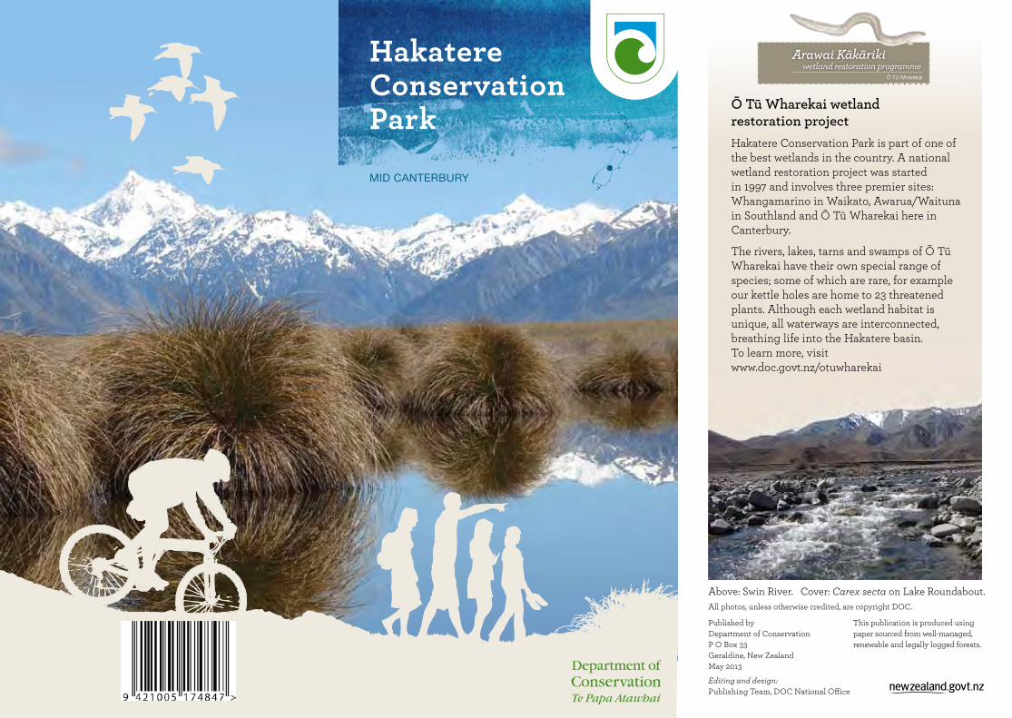
Hakatere Conservation Park
MID CANTERBURY
Published by Department of ConservationP O Box 33Geraldine, New ZealandMay 2013
Editing and design: Publishing Team, DOC National Office
Ō Tū Wharekai wetland restoration projectHakatere Conservation Park is part of one of the best wetlands in the country. A national wetland restoration project was started in 1997 and involves three premier sites: Whangamarino in Waikato, Awarua/Waituna in Southland and Ō Tū Wharekai here in Canterbury.
The rivers, lakes, tarns and swamps of Ō Tū Wharekai have their own special range of species; some of which are rare, for example our kettle holes are home to 23 threatened plants. Although each wetland habitat is unique, all waterways are interconnected, breathing life into the Hakatere basin. To learn more, visit www.doc.govt.nz/otuwharekai
Above: Swin River. Cover: Carex secta on Lake Roundabout.All photos, unless otherwise credited, are copyright DOC.
This publication is produced using paper sourced from well-managed, renewable and legally logged forests.

0 5
kilometres
North
Methven
Rakaia River
Rangitata River
South Branch Ashburton/Hakatere River
Lake Heron
Mt Sunday
77
Lake Clearwater
Lake Emma
72
Mt Somers
Staveley
North B
ranch Ashburton/Hakatere River
Mt Hutt2185
Mt Winterslow1700
Mt Harper/Mahaanui1829
Mt Potts2184
Mt Arrowsmith2781
Mt Taylor2333
Mt Somers/Te Kiekie1687
Lake Coleridge
Mt Barrosa1364Hakatere
Rakaia Gorge
Stou
r Rive
r
Cameron River
TurtonsSaddle
Double Hill682
P A L M E R R A N G E
ASHBURTON GORGE ROAD
HAKATERE POTTS ROAD
HAKATERE H
ERON
RO
AD
DOUBLE HILL RUN ROAD
Lake Roundabout
Lake Camp
Lake Emily
BLAC
KFOR
D R
OAD
Terri
ble
Gul
ly
Potts Rive
rENSORS RD
Cameron Hut
AR
RO
WS
MI T
H
R
AN
GE
Rakaia River
77
Public conservation land
Interpretation centre
Car park
Toilets
Camping
Food
Wildlife refuge
Row boats
No dogs
No power boats
Key to map symbols
All map backgrounds by Geographx Ltd
Map informationNZTopo50
• BW 17 Harihari
• BW 18 Whitcombe Pass
• BW 19 Taylors Camp
• BW 20 Lake Coleridge
• BX 17 Mount Sibbald
• BX 18 Lake Clearwater
• BX 19 Hakatere
• BX 20 Methven
See page 24
See page 18
See page 14
See page 13

32
Hakatere Conservation Park
Shaped by the past, conserved for the future.
Takata whenua—the first people of the land Te Kopi o Hakatere/Ashburton Gorge was the main pounamu/greenstone trail for the Arowhenua hapū—Kāti Huirapa. The trail connects the upper reaches of the Rakaia to Noti Raureka/Browning Pass and then heads down to Te Tai Poutini/the West Coast. Travellers gathered food as they made their way from one coast to the other. The name Ō Tū Wharekai, given to the Ashburton lakes and upper Rangitata River area, is not a literal translation, that is, ‘the place of a food storehouse’, but is a poetic description of the area as a well-stocked natural food basket on the journey to the Arahura, the pounamu capital of the Māori world.
European historyIn this area pastoral farming, particularly merino sheep farming, was the dominant activity in early days of European settlement. Within the park, there is evidence of this in the historic hut at Lake Emma, the Hakatere Station buildings, musterers’ huts and pack tracks.
Native vegetation, regarded as an obstruction to travel and grazing, was often cleared by burning. L Kennaway, an early run holder, described setting fire to the hill country to get
his stock through: “. . . a hot, roaring belt of fire blazed up the hill-side, hissing and crackling and . . . absolutely screaming human screams, as the thick untouched jungle of scores of years withered and twisted in the flames.”
The arrival of the railway to Mount Somers in 1889 made the region more accessible, sheep transportation much easier and the mining of minerals more economically viable. It led to the development of service-centre townships at Methven and Mount Somers.
Hakatere cornerThe buildings at Hakatere corner are a good place to start your exploration of this dramatic area. They include one of mid-Canterbury’s oldest dwellings, the ‘Stone Cottage’, which was constructed in 1862 to accommodate the manager of Hakatere Station. While you are there, call in to the interpretation room, which is housed in the shearers’ quarters, and discover more about the history of the area and the buildings themselves.
Photo: Chaffey family collection Photo: Gilbert Donaldson
Hakatere corner farm buildings

54
Fescue tussock and snow tussock grasslands are common, with remnants of largely mountain beech/tawhairauriki forest along the eastern foothills. Second-growth forest is also present in pockets along the foothills. Species include broadleaf/kāpuka, Hall’s tōtara, tree fuchsia/kōtukutuku, marble leaf/putaputāweta, kōhūhū and pōkākā, with the understorey dominated by crown fern and bush lawyer. Southern rātā, a botanical rarity in this part of Canterbury, is also found in places.
Threatened plants in the area include a tiny forget-me-not (Myosotis brevis), a sedge (Carex tenuiculmis) and one of the largest known populations of a native lily, Iphigenia novae-zelandiae, in New Zealand.
Wetlands in the park include some of the best examples of red tussock (Chionochloa rubra) and Carex secta/pūkio in Canterbury.
An extensive network of kettle hole wetlands, with associated turf vegetation, occurs among moraines and is a rare habitat type nationally. Many threatened turf-
forming plants are found here, including pygmy clubrush (Isolepis basilaris), dwarf woodrush (Luzula celata) and a water brome or semi-aquatic grass (Amphibromus fluitans).
. . . and native animals The rivers, lakes and wetlands provide nationally important habitats for many bird species including the endangered wrybill/ngutu pare, black-fronted tern/tarapirohe, Australasian crested grebe/kāmana, Australasian bittern/matuku and marsh crake/koitareke.
Lizards/ngārara are also found, including the scree skink/mokomoko, one of New Zealand’s largest lizards. There is a spectacular and distinct wētā, Mount Somers giant wētā, a Deinacrida species, as well as native fish and a diverse range of aquatic and terrestrial invertebrates.
Native plants you might see
Bulbinella hookeri
Bladderwort
Gentians in a kettle hole
Scree skink
The lakes and boatingBecause of high wildlife values, boating on most of the lakes is restricted to paddle-propelled craft only. However, on Lake Camp (Ōtautari), motor, wind and paddle-propelled boats are permitted, while on Lake Clearwater (Te Puna a Taka), motor boats are not permitted.
For all boating regulations, refer to: ecan.govt.nz and search for Bylaws
Australasian crested grebe/kāmana Photo: © Peter Langlands
76
Track gradesChoose the type of track that matches your skills, fitness and the experience you want—be realistic.
Walking trackGentle walking from a few minutes to a day.Track is mostly well formed. Some sections may be steep, rough or muddy.Suitable for people with low to moderate fitness and abilities.Clearly signposted. Stream and river crossings are bridged.Walking shoes or light tramping/hiking boots are required.Tramping track Challenging day or multi-day tramping/hiking.Track is mostly unformed with steep, rough or muddy sections.Suitable for people with good fitness. Moderate to high level of back country skills and experience, including navigation and survival skills, required.Track has markers, poles or rock cairns.Expect unbridged stream and river crossings.Tramping/hiking boots required.
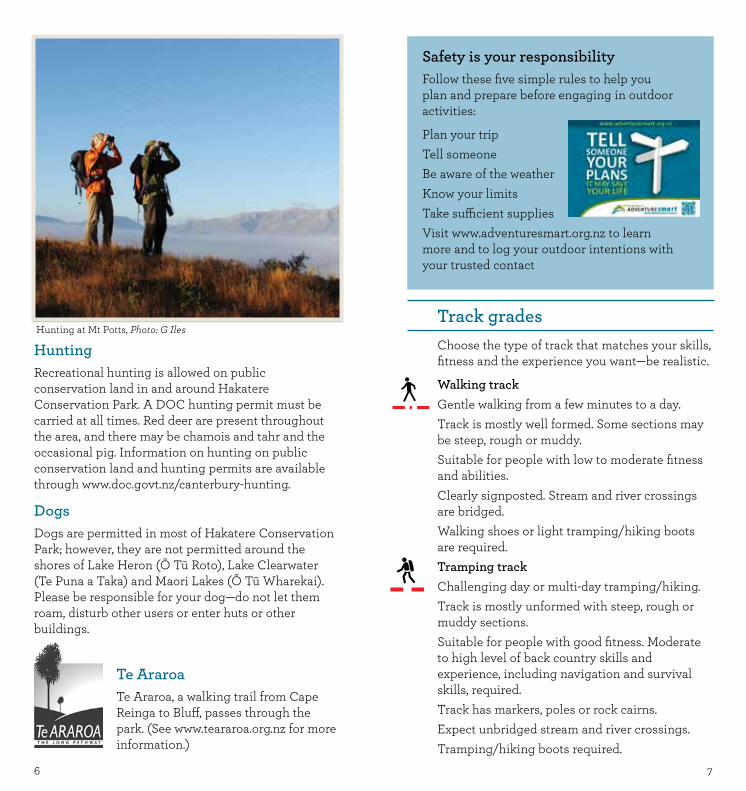
HuntingRecreational hunting is allowed on public conservation land in and around Hakatere Conservation Park. A DOC hunting permit must be carried at all times. Red deer are present throughout the area, and there may be chamois and tahr and the occasional pig. Information on hunting on public conservation land and hunting permits are available through www.doc.govt.nz/canterbury-hunting.
DogsDogs are permitted in most of Hakatere Conservation Park; however, they are not permitted around the shores of Lake Heron (Ō Tū Roto), Lake Clearwater (Te Puna a Taka) and Maori Lakes (Ō Tū Wharekai). Please be responsible for your dog—do not let them roam, disturb other users or enter huts or other buildings.
Te AraroaTe Araroa, a walking trail from Cape Reinga to Bluff, passes through the park. (See www.teararoa.org.nz for more information.)
Safety is your responsibilityFollow these five simple rules to help you plan and prepare before engaging in outdoor activities:
Plan your tripTell someoneBe aware of the weatherKnow your limitsTake sufficient suppliesVisit www.adventuresmart.org.nz to learn more and to log your outdoor intentions with your trusted contact
Hunting at Mt Potts, Photo: G Iles

98
Route Challenging day or multi-day tramping/hiking.Track unformed and natural, rough, muddy or very steep.Suitable for people with above-average fitness. High-level backcountry skills and experience, including navigation and survival skills, required.Complete self-sufficiency is required.Track has markers, poles or rock cairns. Expect unbridged stream and river crossings.Sturdy tramping/hiking boots required.
Mountain bike tracksGrade 2: mostly flat with some gentle climbs on smooth track, with easily avoidable obstacles such as rocks and potholes.
EasementsAn easement is a public right of way across private land. Please stay on the marked route.
Please rememberPlease remember that mountain biking tracks are being shared with walkers and trampers, and other bikers who may be moving in either direction. It should be ridden in accordance with the ‘Mountain Bikers Code’:
4WD care code Please follow the code of conduct to protect the environment and for the long-term sustainability of off-road driving. • Avoid sensitive areas. Alpine landscapes,
swamps, waterways, sand dunes and riverbeds are easily damaged by vehicles.
• Abide by the laws and regulations covering all vehicles and drivers.
• Stay on roads. Avoid widening them. • Keep the environment clean. Take all your
rubbish with you. • Respect wildlife; look but don't disturb and keep
your distance. • Find out if a permit is required for access. If your
trip crosses private land obtain permission. • Leave gates as you find them. • Always thoroughly clean your vehicle before
and after trips to minimise spreading weeds and diseases.
• Respect the right of others for quiet enjoyment. Avoid noisy driving. Give way to walkers, cyclists, horse riders and others.
• Be prepared for the unexpected. Drive at a speed that will allow you to stop if a hazard arises.
• If winching is necessary, wherever possible, use another vehicle. If you must use a tree, use webbing or padding to prevent damaging the tree.
• Cross waterways with care. Use designated crossings wherever possible.

1110
Horse riding care code Ride with care for the environment and others. Sharing tracks and trails When using tracks that are shared with mountain bikers, walkers and 4WD drivers, approach blind corners no faster than a walk, as other users may be just around the corner. Pass others at a walk and keep your horse under control at all times.
Weeds and disease • Before entering conservation areas, please make
sure all your horse riding gear is cleaned and free of seeds and soil, which may spread weeds and disease. Also thoroughly clean your horse’s hooves and your float or truck.
• Only allow your horse to eat weed-free feed at least 48 hours before entering a conservation area. Weed-free feed includes clean chaff, pellets and cracked, rolled or steamed grains. Never take meadow hay as it often contains seed. If you can't
do this, then carry bags, pick up your horse’s poo and take it home with you.
• When carrying hard feed, take a nosebag for your horse. It minimises spillage, which adds to the food supply for pests such as mice and rats.
• Consider undertaking some basic education in weed and seed identification, and assisting DOC in identifying and eliminating new outbreaks of problem species.
Protecting the environment • Please do not take horses into fragile natural
areas that have a high conservation value, such as swamp land, sand dunes or fragile alpine areas. Horses can damage natural ecosystems by trampling and grazing. Be observant and avoid unduly disturbing unstable or erosion-prone soils.
• When crossing waterways, select firm, stony crossings, and cross at a 90˚ angle to the banks. Use bridges or well-used crossings wherever possible to limit erosion of the banks.
• Carry and use canvas or collapsible buckets and/or pump and hose where possible to water and wash horses.
Using campsites and huts
• When staying more than one night in the same place, relocate portable yards each night to help minimise trampling and vegetation damage.
• Use tree protectors when putting up nightlines to prevent trees from being damaged. Incorporate stops in the nightlines to prevent horses moving and becoming entangled in trees.
• Where possible, make nightlines at least 15 m long to reduce concentrated impact.
• Always camp horses well clear of watercourses (at least 50 m away). Wash and water horses downstream from where other campers get their water.
• Remove horse manure from hut and campsite areas. Take it home with you or scatter it so that it degrades faster. Take all your rubbish and recycling with you—don’t bury or burn it.
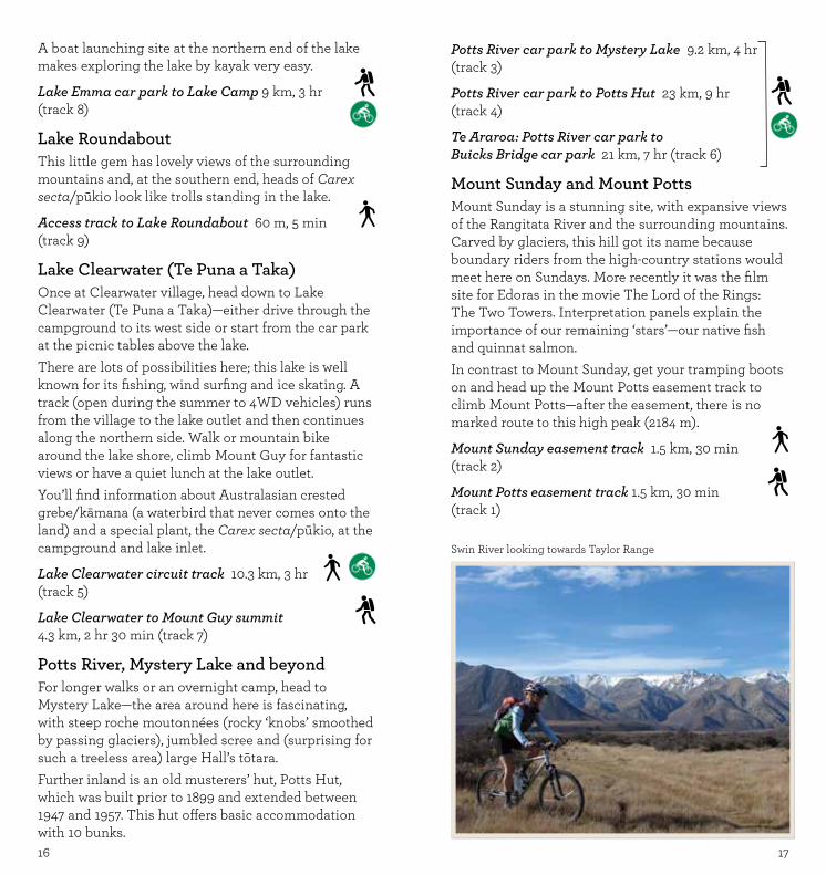
Swin River looking towards Taylor Range

Manuka Hut6 bunks
Historic farm buildings
Mt Barrosa1364
Hakatere HA
KAT
ER
E H
ER
ON
RO
AD
Manuka Lake
Lake Emily
0 2
kilometres
N
MT
SO
MER
S R
ANG
E
Maori Lakes
Stou
r Ri
ver
TE ARAROA
Stour Bridge
ASHBURTON GORGE ROAD
13
12Blowing
Point Bridge
1312
AccessThere are a number of different access points into Hakatere Conservation Park:
Ashburton Gorge RoadVisit Stour River and Mount Barrosa.
Hakatere Potts RoadExplore Lake Emma (Kirihonuhonu), Lake Clearwater (Te Puna a Taka), Mount Sunday or Mount Potts.
Hakatere Heron Road Discover Buicks Bridge, Maori Lakes (Ō Tū Wharekai), Lake Emily, Lake Heron (Ō Tū Roto) and Cameron River.
Blackford Road / Double Hill Run Road Enjoy Mount Hutt Range, Redcliffe Scenic Reserve, Turtons Saddle, Double Hill and the Palmer Range
Ashburton Gorge RoadAccess along this road has not always been easy; originally it was rutted and poorly made. To get the coal, clay, silica sand and limestone down to the township, a horse-drawn tramway was built in 1901 and was converted to steam in 1907. This branch line ran until 1940, by which time the Ashburton Gorge Road had been improved to a high enough standard for trucks to use. Today, as you travel this same route, it is difficult to visualise the difficulties the early travellers had.
Stour RiverThere is easy access to Lake Emily and Manuka Hut from the car park at Stour Bridge. The track follows the Stour River, which is carving its way through rhyolite bedrock, formed during volcanic eruptions. When this molten rock flowed past, it would have been between 700°C and 1200°C. As the lava cooled, it split, making the columns that can be seen along the valley sides. The rhyolite makes a rich soil, which supports a wide range of plants. You will see bright green patches of broadleaf/kāpuka, while the dull green, deciduous trees are mountain ribbonwood/houhi. Mountain
beech/tawhairauriki is also here; it can grow on mountain sides up to 1260 m! If you go off track, watch out for live ammunition.This land was once used for army training, and there may still be live ammunition lying around. If you see any suspicious items, do not handle them. If possible, note the location and inform the police as soon as possible.
Stour Bridge car park to Lake Emily 15 km, 5 hr (track 13)
Mount BarrosaThis easily obtainable peak gives good views out across the Conservation Park and even to Aoraki/Mount Cook.A small car park on Ashburton Gorge Road, about 500 m east of Blowing Point Bridge, gives access to public conservation land after a walk of 780 m.
Mount Barrosa summit track 3.5 km, 2 hr 30 min (track 12)

Rangitata River
Mt Potts2184
Boundary Creek Hut8 bunks
Potts Hut10 bunks
Historic farm buildings
Boundary Creek
Potts River
Potts R
iver
South Branch Ashburton River / Hakatere
Paddle Hill Creek
The Pyramid1748
Powerhouse Stream
Lake Clearwater
Lake Camp Lake Roundabout
Spider Lakes
Maori Lakes
Mt Sunday611
Lake DonneLake Clearwater
Lake Heron
Mt Guy1319
D OG
S R A NG
E
PO
T T S R A N G E
Lake Emma
H A R P E R R A N G E
HAKATERE POTTS ROAD
HAKATERE H
ERON
ROAD
Hakatere
Mystery Lake
Buicks Bridge
TE ARAROA
0 2
kilometres
N
8
9
5
7
3
4
6
6
2
1
4 10
11
11
Lake Emma Hut (historic)
Mt Potts Station
1514
Hakatere Potts RoadThis area offers a variety of lakes (for boating, ice skating and fishing), walks from 5 minutes to all day, a ‘Lord of the Rings’ site, two old musterers’ huts, mountain biking, hunting and an area popular for horse trekking. See the Hakatere Heron Road section for alternative access into the Clearwater area from Buicks Bridge.
Lake Emma (Kirihonuhonu)Walk or mountain bike to the historic Lake Emma Hut (overnight stays are not allowed) and then on to Lake Camp (Ōtautari). The two-room hut at Lake Emma, with its tack shed and verandah, was built between the late 1860s and 1890. It sits by the lake shore and is a lovely spot for a breather or lunch.During the summer, there is weather-dependent 4WD access to Lake Emma Hut; this makes it easier for picnicking, fishing or those who are less mobile.
1716
A boat launching site at the northern end of the lake makes exploring the lake by kayak very easy.
Lake Emma car park to Lake Camp 9 km, 3 hr (track 8)
Lake Roundabout This little gem has lovely views of the surrounding mountains and, at the southern end, heads of Carex secta/pūkio look like trolls standing in the lake.
Access track to Lake Roundabout 60 m, 5 min (track 9)
Lake Clearwater (Te Puna a Taka)Once at Clearwater village, head down to Lake Clearwater (Te Puna a Taka)—either drive through the campground to its west side or start from the car park at the picnic tables above the lake.There are lots of possibilities here; this lake is well known for its fishing, wind surfing and ice skating. A track (open during the summer to 4WD vehicles) runs from the village to the lake outlet and then continues along the northern side. Walk or mountain bike around the lake shore, climb Mount Guy for fantastic views or have a quiet lunch at the lake outlet.You’ll find information about Australasian crested grebe/kāmana (a waterbird that never comes onto the land) and a special plant, the Carex secta/pūkio, at the campground and lake inlet.
Lake Clearwater circuit track 10.3 km, 3 hr (track 5)
Lake Clearwater to Mount Guy summit 4.3 km, 2 hr 30 min (track 7)
Potts River, Mystery Lake and beyondFor longer walks or an overnight camp, head to Mystery Lake—the area around here is fascinating, with steep roche moutonnées (rocky ‘knobs’ smoothed by passing glaciers), jumbled scree and (surprising for such a treeless area) large Hall’s tōtara. Further inland is an old musterers’ hut, Potts Hut, which was built prior to 1899 and extended between 1947 and 1957. This hut offers basic accommodation with 10 bunks.
Potts River car park to Mystery Lake 9.2 km, 4 hr (track 3)
Potts River car park to Potts Hut 23 km, 9 hr (track 4)
Te Araroa: Potts River car park to Buicks Bridge car park 21 km, 7 hr (track 6)
Mount Sunday and Mount PottsMount Sunday is a stunning site, with expansive views of the Rangitata River and the surrounding mountains. Carved by glaciers, this hill got its name because boundary riders from the high-country stations would meet here on Sundays. More recently it was the film site for Edoras in the movie The Lord of the Rings: The Two Towers. Interpretation panels explain the importance of our remaining ‘stars’—our native fish and quinnat salmon.In contrast to Mount Sunday, get your tramping boots on and head up the Mount Potts easement track to climb Mount Potts—after the easement, there is no marked route to this high peak (2184 m).
Mount Sunday easement track 1.5 km, 30 min (track 2)
Mount Potts easement track 1.5 km, 30 min (track 1)
Swin River looking towards Taylor Range
Mt Winterslow1700
Mt Taylor2333
Comyns Hut8 bunks
A-frame Hut3 bunks
Double Hut6 bunks
Manuka Hut6 bunks
Historic farm buildings
Mt Barrosa1364Hakatere
Lake Heron
HA
KATER
E HERO
N RO
AD
Seagull Lake
Manuka Lake
Lake Emily
TAYLOR
RAN
GE
BLA
CK
HILL R
ANG
E
0 2
kilometres
N
MT
SO
MER
S R
ANG
E
Maori Lakes
Stou
r Ri
ver
TE ARARO
A
TE ARAROA
Stour Bridge
Lake Hill
Harrisons Bight
Kettle holes
Buicks Bridge
Cameron River
Clent Hills Saddle
14
18
13
15
16
17
Mt Arrowsmith Station
12
Castleridge Station
1918
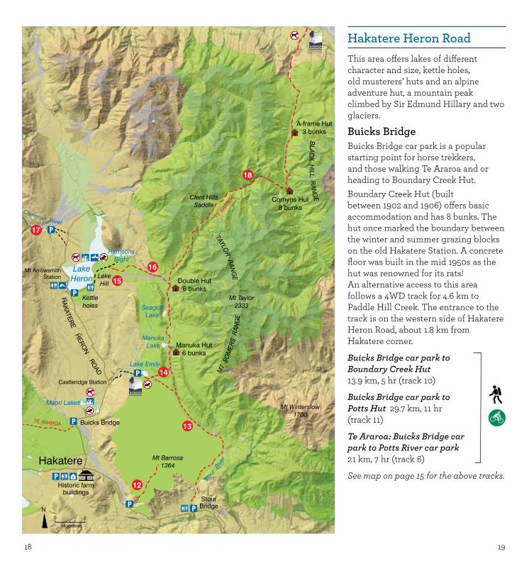
Hakatere Heron RoadThis area offers lakes of different character and size, kettle holes, old musterers’ huts and an alpine adventure hut, a mountain peak climbed by Sir Edmund Hillary and two glaciers.
Buicks BridgeBuicks Bridge car park is a popular starting point for horse trekkers, and those walking Te Araroa and or heading to Boundary Creek Hut. Boundary Creek Hut (built between 1902 and 1906) offers basic accommodation and has 8 bunks. The hut once marked the boundary between the winter and summer grazing blocks on the old Hakatere Station. A concrete floor was built in the mid 1950s as the hut was renowned for its rats!An alternative access to this area follows a 4WD track for 4.6 km to Paddle Hill Creek. The entrance to the track is on the western side of Hakatere Heron Road, about 1.8 km from Hakatere corner.
Buicks Bridge car park to Boundary Creek Hut 13.9 km, 5 hr (track 10)
Buicks Bridge car park to Potts Hut 29.7 km, 11 hr (track 11)
Te Araroa: Buicks Bridge car park to Potts River car park 21 km, 7 hr (track 6)
See map on page 15 for the above tracks.
2120
Lake Emily also gives access on old farm tracks to Stour Bridge car park. From the lake, the route is mostly down hill, making it an easy walk and an even easier mountain bike ride!
Lake Emily to Stour Bridge car park 15 km, 5 hr(track 13)
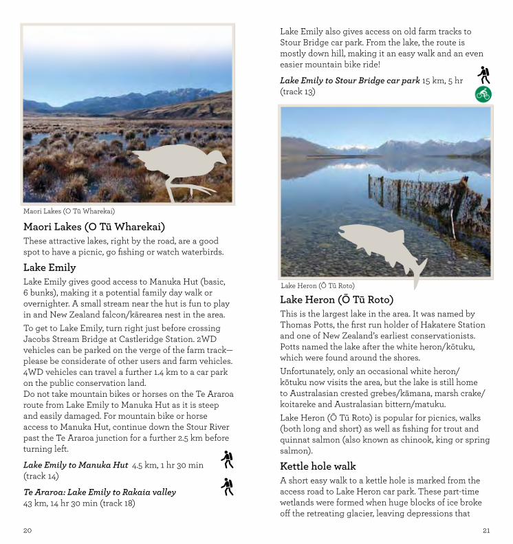
Lake Heron (Ō Tū Roto) This is the largest lake in the area. It was named by Thomas Potts, the first run holder of Hakatere Station and one of New Zealand’s earliest conservationists. Potts named the lake after the white heron/kōtuku, which were found around the shores. Unfortunately, only an occasional white heron/kōtuku now visits the area, but the lake is still home to Australasian crested grebes/kāmana, marsh crake/koitareke and Australasian bittern/matuku.Lake Heron (Ō Tū Roto) is popular for picnics, walks (both long and short) as well as fishing for trout and quinnat salmon (also known as chinook, king or spring salmon).
Kettle hole walkA short easy walk to a kettle hole is marked from the access road to Lake Heron car park. These part-time wetlands were formed when huge blocks of ice broke off the retreating glacier, leaving depressions that
Maori Lakes (O Tū Wharekai)These attractive lakes, right by the road, are a good spot to have a picnic, go fishing or watch waterbirds.
Lake EmilyLake Emily gives good access to Manuka Hut (basic, 6 bunks), making it a potential family day walk or overnighter. A small stream near the hut is fun to play in and New Zealand falcon/kārearea nest in the area. To get to Lake Emily, turn right just before crossing Jacobs Stream Bridge at Castleridge Station. 2WD vehicles can be parked on the verge of the farm track—please be considerate of other users and farm vehicles. 4WD vehicles can travel a further 1.4 km to a car park on the public conservation land.Do not take mountain bikes or horses on the Te Araroa route from Lake Emily to Manuka Hut as it is steep and easily damaged. For mountain bike or horse access to Manuka Hut, continue down the Stour River past the Te Araroa junction for a further 2.5 km before turning left.
Lake Emily to Manuka Hut 4.5 km, 1 hr 30 min (track 14)
Te Araroa: Lake Emily to Rakaia valley 43 km, 14 hr 30 min (track 18)
Maori Lakes (O Tū Wharekai)
Lake Heron (Ō Tū Roto)

2322
each with about six dogs, and a ‘packie’ who cooked for the gang.Sir Edmund Hillary visited the hut and climbed Mount Taylor. Though it is only about one-quarter of the height of Mount Everest, the view from the top over Lake Heron (Ō Tū Roto) and to Aoraki/Mount Cook is breathtaking.
Lake Heron car park to Double Hut 10 km, 3 hr (track 16)
Te AraroaTe Araroa crosses Clent Hills Saddle, connecting the Rakaia and Rangitata rivers. This long-distance pathway passes close to Double Hut.
Cameron valleyTo reach Cameron valley, drive past Mt Arrowsmith Station towards the head of Lake Heron (Ō Tū Roto) for about 1.6 km. Just past a gravel pit follow an unmarked 4WD track for about 1.4 km to the start of a route up the true right of the Cameron valley. Cameron Hut (basic, 9 bunks), which is owned by the Canterbury Mountaineering Club, sits amongst piles of moraine from the Cameron Glacier. The hut has stunning views of the Arrowsmith Range, and tahr have been seen from the hut bunks.Please be aware that Cameron Hut is subject to a low level of avalanche risk.
Cameron Hut route (unmarked) 15.6 km, 6 hr (track 17)
sometimes fill with water. The flowering plants that live in kettle holes are mostly very small, rare and have special ways of using the changing water levels to their advantage. The interpretation panel gives more information.
Harrisons Bight and Lake HillLake Heron car park is 1.7 km along the shore from Hakatere Heron Road. From here, there is summer 4WD access to Harrisons Bight. For access details contact DOC’s Geraldine office.From the car park, there is an easy walk up Lake Hill. The Hill is a great place to appreciate the lake and surrounding mountains and the effects of past glaciers. An interpretation panel explains how water shaped the landscape and is shaping it still.
Lake Heron car park to Lake Hill 1.5 km, 45 min (track 15)
Double HutAn old musterers’ hut, Double Hut (basic, 6 bunks), makes a good base for exploring the area, climbing Mount Taylor or for hunting.The size of a musterers’ hut reflects the number of musterers needed to get the sheep off the hill. In the early 1990s, a mustering gang comprised four men,
Double Hut
Near Lake Heron (Ō Tū Roto) Photo: G Iles

0 5 10
kilometres
North
Map background by Geographx
Rakaia River
Lake Heron
Mt Hutt2185
Mt Taylor2333
Lake Coleridge
Rakaia Gorge
TurtonsSaddle
Double Hill682
PALMER RANGE
HAKATER
E HER
ON
RO
AD
DOUBLE HILL RUN ROAD
Lake Emily
BLAC
KFOR
D R
OAD
Terrible G
ully
ENSORS RDRakaia River
Comyns Hut8 bunks
A-frame Hut3 bunks
Double Hut6 bunks
Manuka Hut6 bunks
Seagull Lake
Manuka Lake
BL
AC
K H
ILL
RA
NG
E
T
E ARAROA
MT
HU
TT
RA
NG
E
Tribulation Hut
6 bunks
Clent Hills Saddle
Homestead Hill easement
Tarn easement
Stream easement
Redcliffe Scenic
Reserve
19
18
77
2524
Terrible Gully A public easement from Double Hill Run Road to Terrible Gully gives entry onto public conservation land on Mount Hutt Range.
Redcliffe Scenic ReserveA tramping track is marked from a small car park on Double Hill Run Road up the true right of Redcliffe Stream to Tribulation Hut, which has 6 bunks. In September, the kōwhai flowers make a splash of yellow in the scenic reserve by Redcliffe Stream.
Blackford Road/Double Hill Run RoadThe approach to the eastern side of Hakatere Conservation Park is from State Highway 77. Follow Blackford Road, which then becomes Double Hill Run Road up the southern side of the Rakaia. This side of the park is less visited, but has a dramatic quality all of its own with wide tussock valleys and scree-covered peaks. There is no public access from the end of the road to Lake Heron (Ō Tū Roto).

2726
Tour 1Start at Hakatere corner—not only is this the gateway to the area, but there are some good map and interpretative panels to help make your visit more enjoyable!
From here, drive to Maori Lakes (Ō Tū Wharekai), on the Hakatere Heron Road. You can park near the shore, relax and enjoy the sound of the wind in the bulrushes/raupō and the calls of the waterbirds over a ‘cuppa’. Continue to Lake Heron (Ō Tū Roto) and walk to the kettle hole—whether it’s full of water or dry, this glacial depression is worth a visit.
Returning to your car, drive to Lake Heron car park and have lunch by the shore of Lake Heron (Ō Tū Roto). Then walk up Lake Hill (1.5 km 45 min) and enjoy the panoramic views before making a leisurely return to your car.
There are public toilets at Hakatere corner, Lake Heron car park and Mt Arrowsmith Station campground.
A taste of the high countryA car-based, one-day tour, sight seeing and exploring in Hakatere Conservation Park
Rakaia valley to Tribulation Hut 10 km, 3 hr 30 min (track 19)
Te Araroa (Glenariffe easement)Turtons Saddle, with great panoramic views back over one of New Zealand’s iconic braided rivers, is the gateway to the Rakaia River/Rangitata River section of Te Araroa. A wide tussock valley leads to A-Frame Hut (basic, 4 bunks), which was built by the Water Catchment Board in 1970, when they trialled an experimental plot of pine trees. A further 2-hour walk takes you on to Comyns Hut (basic, 8 bunks), which was built in 1957. The framing, timber and corrugated iron were flown in by aeroplane; the window glass and frame arriving later by packhorse. Te Araroa continues over Clent Hills Saddle and drops down past Double Hut (basic, 6 bunks), Manuka Hut (basic, 6 bunks) and Lake Emily before continuing past Lake Clearwater (Te Puna a Taka) to the Rangitata River.
Rakaia valley to A-Frame Hut 9.5 km, 3 hr
A-Frame Hut to Comyns Hut 6.5 km, 2 hr
Comyns Hut to Double Hut 17 km, 7 hr
Te Araroa: Rakaia valley to Lake Emily 43 km, 14 hr 30 min (track 18)
Stream easementA 1-kilometre easement to the public conservation land at Glenariffe Stream is marked from Double Hill Run Road. Be prepared to get wet feet crossing Double Hill Stream.
Tarn easement at Double HillOpposite ‘Stream easement’, a marked 4WD track goes around the base of Double Hill to the Rakaia River. From this track, tarn easement gives access onto Double Hill and views out across the Rakaia River.
Homestead Hill easementEnsors Road branches off Double Hill Run Road opposite Double Hill. A small car park on Ensors Road marks the start of a steep easement onto the Palmer Range.
Lake Heron (Ō Tū Roto)
2928
Mt Sunday
Tour 2Start at Hakatere corner—call in, wander round the old buildings and imagine what life would be like, living with a young family in the old Stone Cottage with a winter gale roaring outside. Then follow Hakatere Potts Road to Lake Clearwater (Te Puna a Taka). In summer, make a 4WD trip out to the lake outlet and stretch your legs, play on the bridge and enjoy the views. Or head through the campground to the lake shore; whilst relaxing, see if you can spot the endangered Australasian crested grebe/kāmana.
After leaving Lake Clearwater (Te Puna a Taka), continue west along Hakatere Potts Road. Just before the road dips steeply down to the Potts River, there is a brilliant viewpoint that offers wide vistas out over the Rangitata River to the backbone of South Island, the Southern Alps/Kā Tiritiri o Te Moana.
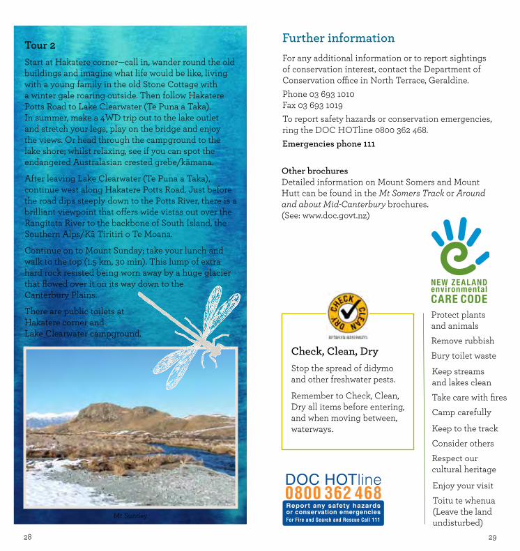
Continue on to Mount Sunday; take your lunch and walk to the top (1.5 km, 30 min). This lump of extra hard rock resisted being worn away by a huge glacier that flowed over it on its way down to the Canterbury Plains.
There are public toilets at Hakatere corner and Lake Clearwater campground.
Check, Clean, DryStop the spread of didymo and other freshwater pests.
Remember to Check, Clean, Dry all items before entering, and when moving between, waterways.
Further informationFor any additional information or to report sightings of conservation interest, contact the Department of Conservation office in North Terrace, Geraldine.Phone 03 693 1010Fax 03 693 1019To report safety hazards or conservation emergencies, ring the DOC HOTline 0800 362 468.Emergencies phone 111
Protect plants and animals
Remove rubbish
Bury toilet waste
Keep streams and lakes clean
Take care with fires
Camp carefully
Keep to the track
Consider others
Respect our cultural heritage
Enjoy your visit
Toitu te whenua(Leave the land undisturbed)
Other brochuresDetailed information on Mount Somers and Mount Hutt can be found in the Mt Somers Track or Around and about Mid-Canterbury brochures. (See: www.doc.govt.nz)
Top Related