


Languages
Pages
Legal


-Learning E. Gilson – R. DeBattista – A. Quintano 2008
GEOGRAPHY OPTION SYLLABUS GEOGRAPHY OPTION SYLLABUS GEOGRAPHY OPTION SYLLABUS GEOGRAPHY OPTION SYLLABUS
FORM 5FORM 5FORM 5FORM 5
Curriculum Management Department - Geography Option 16

GEOGRAPHY OPTION SYLLABUS – FORM 5 5.1 Map Reading and Interpretation
5.2 Weather and Climate
5.3 Landforms and Processes
5.4 Socio-Economic Human Systems
5.5 Environmental Concerns
5.6 Location and Places
5.1.1 Basic cartographic skills: section drawing; intervisibility and gradients. 5.1.2 Recognition of landforms resulting from glaciation. 5.1.3 Interpretation of communication patterns and location of economic activity.
Tropical Rainforest 5.2.1 Equatorial climate. 5.2.2 Appearance (vegetation levels) and adaptation of the vegetation. 5.2.3 Rainforest water and nutrient cycle. Tropical Savanna Grasslands 5.2.4 Tropical Continental Climate. Appearance of Tropical Savanna Grasslands and adaptation of the vegetation.
The Earth as a Planet 5.3.1 Effects of the Earth’s revolution – (a) the seasons; (b) the varying lengths of day and night. Ice Landscapes 5.3.2 The Ice Age. 5.3.3 Processes of ice erosion – abrasion, plucking and freeze-thaw weathering (frost shattering).
Industrial Activity 5.4.1 Classification of economic activities – Primary, Secondary, Tertiary and Quaternary. 5.4.2 Comparing employment structures – triangular graphs. 5.4.3 Industry as a system: inputs, processes and outputs. 5.4.4 Factors affecting industrial location. Footloose Industries.
Ecosystems 5.5.1 How an ecosystem works. 5.5.2 Basic processes of an ecosystem: flow of energy and the recycling of nutrients. 5.5.3 Distribution of major world natural vegetation zones (biomes). 5.5.4 Case Study: Causes and effects of deforestation in the Amazon Rainforest. 5.5.5 Sustainable Forestry.
5.6.1 Location of deserts: Californian, Arizona, Atacama, Sahara, Namib, Kalahari, Arabian, Thar, Gobi, Australian. 5.6.2 Distribution of major world biomes: Tundra, Taiga (coniferous forests), Temperate deciduous forests, Temperate Grasslands, Mediterranean, Hot Desert, Tropical Rainforests, Savanna Grasslands.
Curriculum Management Department - Geography Option - Form 5 1

Mediterranean Climate 5.2.5 Mediterranean type of Climate. Natural Vegetation: Woodland and scrub (maquis and garigue). Adaptation of the vegetation to the summer drought. Tropical Desert Climate 5.2.6 Climate characteristics of tropical deserts. How plants and wildlife survive in tropical deserts. Monsoon Climate 5.2.7 Monsoon climate characteristics with special reference to the Indian sub-continent.
5.3.4 Processes that lead to the formation of glacial features – hanging valleys, corries (cirques/cwms), pyramidal peaks (horns), truncated spurs, arêtes, U shaped glacial troughs, ribbon lakes. 5.3.5 Types of moraine – ground, lateral, medial and terminal. Features of glacial deposition – erratics and drumlins. 5.3.6 Landuse in glacial areas (farming, forestry, water supply, HEP and tourism). Hot Desrts 5.3.7 Desert environment: rainfall and temperature characteristics.
5.4.5 Industrial change – deindustrialisation (decline in primary and in manufacturing industries) – South Wales or the Rhine –Ruhr industrial region as an example. 5.4.6 High technology industry – the M4 corridor in the UK. 5.4.7 Multinational or transnational corporations (TNCs). Positive and negative impacts of TNCs. 5.4.8 Global Industry. 5.4.9 Emergence of newly industrialised countries (NICs) – The Pacific Rim.
5.5.6 Case Study: Desertification in the Sahel 5.5.7 Destruction of the natural vegetation by deforestation, grazing animals and fire.
5.6.3 The location of these major ports: Vancouver, Seattle, San Francisco, Los Angeles, New York, Caracas, Rio de Janeiro, São Paulo, Buenos Aires, Rotterdam, Antwerp, Barcellona, Marseilles, Trieste, Genoa, Valletta, Istanbul, Port Said, Cape Town, Mumbai, Madras, Singapore, Hong Kong, Shangai, Tokyo, Osaka-Kobe, Sydney, Melbourne. 5.6.4 Location of the following ice covered areas: Antarctica, Greenland, Iceland, Spitzbergen, Bearing Sea, Baltic Sea, White Sea.
Curriculum Management Department - Geography Option - Form 5 2

5.3.8 Weathering in Hot Deserts: the effects of exfoliation. 5.3.9 Water as an agent in the formation of desert scenery (wadis, playas, isolated hills – inselbergs, mesas and buttes). 5.3.10 Landforms produced by wind: deflation hollows, rock pedestals, yardangs and zeugens, and sand dunes (barchans).
5.4.10 Case Study: Industry in Osaka-Kobe conurbation. 5.4.11 Case Study: Industry in São Paolo. World Development 5.4.12 The development gap; the North-South divide. 5.4.13 Measuring development – indicators of development – economic and social indicators e.g. GNP, mortality rate, life expectancy, literacy rate, housing, diet etc.). 5.4.14 The Human Development Index (HDI). 5.4.15 Causes and consequences of inequalities in world development.
Curriculum Management Department - Geography Option - Form 5 3

5.4.16 Trading blocs – tariffs and quotas – (EU, NAFTA, LAFTA, OPEC, ASEAN). 5.4.17 Types of aid: bilateral, multilateral, voluntary and emergency aid. 5.4.18 The benefits and problems of aid. 5.4.19 Case Study: Countries with different levels of development. Japan and Kenya. 5.4.20 Difference within countries: Italy.
Curriculum Management Department - Geography Option - Form 5 4
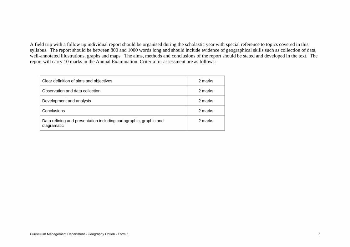
A field trip with a follow up individual report should be organised during the scholastic year with special reference to topics covered in this syllabus. The report should be between 800 and 1000 words long and should include evidence of geographical skills such as collection of data, well-annotated illustrations, graphs and maps. The aims, methods and conclusions of the report should be stated and developed in the text. The report will carry 10 marks in the Annual Examination. Criteria for assessment are as follows:
Clear definition of aims and objectives 2 marks
Observation and data collection 2 marks
Development and analysis 2 marks
Conclusions 2 marks
Data refining and presentation including cartographic, graphic and diagramatic
2 marks
Curriculum Management Department - Geography Option - Form 5 5

Geography Option
Form 5
Learning Outcomes
Curriculum Management Department - Geography Option - Form 5 6

5.1.1 Basic cartographic skills:
section drawing; intervisibility and gradients.
• Carry out simple calculations to find out the gradient of slopes between two places on a topographic map.
• Draw an accurate cross-section between two given points on a topographic map.
• Noting and labeling given features on the cross-section.
• Determining intervisibility between two points on the cross-section.
• Identify the following slope patterns by means of contours: concave slope, convex slope, even slope, compound slope and cliff.
5.1.2 Recognition of landforms resulting from glaciation.
• Identify the following erosional glacial features on topographical maps: hanging valleys, corries (cirques/cwms), arêtes, pyramidal peaks (horns), U-shaped glacial troughs, ribbon lakes.
Map
Rea
ding
and
inte
rpre
tatio
n
5.1.3 Interpretation of communication patterns and location of economic activity.
• Differentiate between classifications of transport networks including types of railways and roads, electricity transmission lines, bridges, stations, tunnels, heliports, ferries, quays, jetties, docks and lighthouses.
• Identifying evidence of primary industry including mining and quarrying, that is mines, waste heaps, quarries, freight lines.
• Understand the rural landscapes in topographic maps by noting high or low density of farms and fields, noting and distinguishing between coniferous and deciduous woodland and other features relating to farming activities such as reservoirs, wind-pumps, water tanks, drainage ditches, glasshouses and windmills.
Curriculum Management Department - Geography Option - Form 5 7
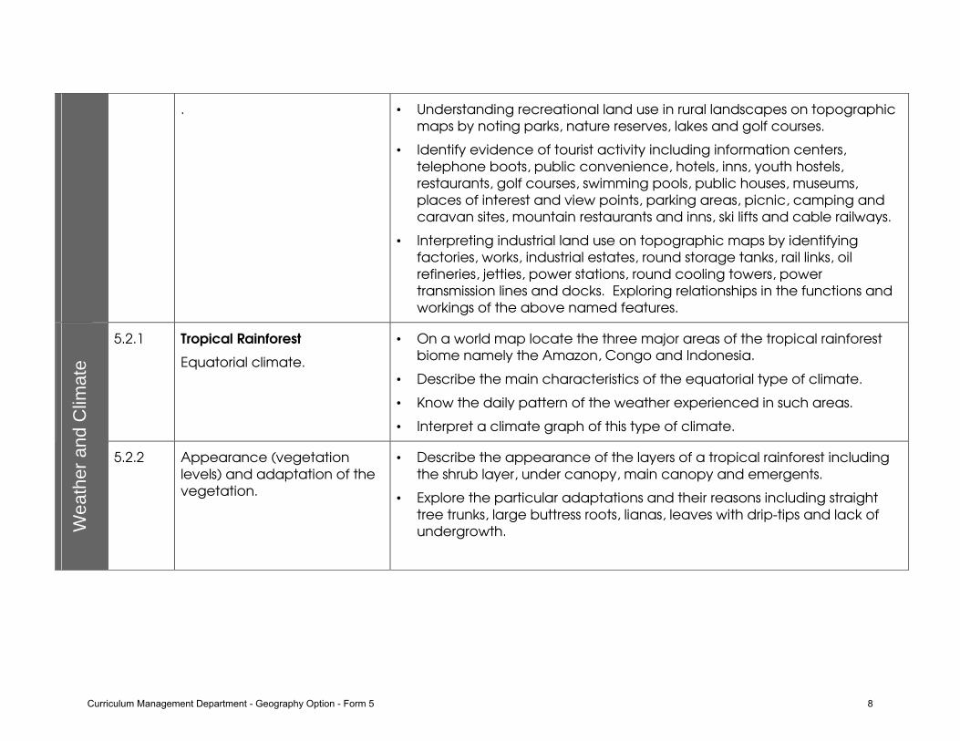
. • Understanding recreational land use in rural landscapes on topographic maps by noting parks, nature reserves, lakes and golf courses.
• Identify evidence of tourist activity including information centers, telephone boots, public convenience, hotels, inns, youth hostels, restaurants, golf courses, swimming pools, public houses, museums, places of interest and view points, parking areas, picnic, camping and caravan sites, mountain restaurants and inns, ski lifts and cable railways.
• Interpreting industrial land use on topographic maps by identifying factories, works, industrial estates, round storage tanks, rail links, oil refineries, jetties, power stations, round cooling towers, power transmission lines and docks. Exploring relationships in the functions and workings of the above named features.
5.2.1 Tropical Rainforest
Equatorial climate.
• On a world map locate the three major areas of the tropical rainforest biome namely the Amazon, Congo and Indonesia.
• Describe the main characteristics of the equatorial type of climate.
• Know the daily pattern of the weather experienced in such areas.
• Interpret a climate graph of this type of climate.
Wea
ther
and
Clim
ate
5.2.2 Appearance (vegetation levels) and adaptation of the vegetation.
• Describe the appearance of the layers of a tropical rainforest including the shrub layer, under canopy, main canopy and emergents.
• Explore the particular adaptations and their reasons including straight tree trunks, large buttress roots, lianas, leaves with drip-tips and lack of undergrowth.
Curriculum Management Department - Geography Option - Form 5 8

5.2.3 Rainforest water and nutrient cycle.
• Apply the nutrient cycle to the tropical rainforest.
• Aware of the consequences of tree clearance to the nutrient cycle of the tropical rainforest.
5.2.4 Tropical Savanna Grasslands
Tropical Continental Climate. Appearance of Tropical Savanna Grasslands and adaptation of the vegetation.
• On a world map locate the five major areas of the tropical continental climate (savanna) namely the Mexico, Venezuela, Brazil (Mato Grosso), Sahel region and east Africa, and parts of northern Australia.
• Describe the main characteristics of the tropical continental type of climate (savanna).
• Know the seasonal pattern of the weather experienced in such areas.
• Interpret a climate graph of this type of climate.
• Understand how the natural vegetation of the savanna has adapted to the hot temperatures and drought during the dry season.
Wea
ther
and
Clim
ate
5.2.5 Mediterranean Climate
Mediterranean type of Climate.
Natural Vegetation: Woodland and scrub (maquis and garigue).
Adaptation of the vegetation to the summer drought.
• On a world map locate the six areas of the Mediterranean type of climate namely the Mediterranean region, California, Central Chile, South Africa, South-west Australia and South Australia.
• Identifying the general position of such areas that is between 30º and 40º latitude on the western margins of continents.
• Describe the main characteristics of the Mediterranean type of climate.
• Know the seasonal pattern of the weather experienced in such areas.
• Interpret a climate graph of this type of climate.
Curriculum Management Department - Geography Option - Form 5 9

• Describe the two main types of Mediterranean natural vegetation namely woodland and scrub (maquis and garigue).
• Name examples of trees typical of Mediterranean woodland including evergreen oaks and conifers.
• Name examples of plants typical of the garigue such as rosemary, lavender and thyme.
• Recognise the difference between maquis and garigue environments using illustrations.
• Explain how these plants adapt to the summer drought including small waxy glossy leaves, thorns, protective barks, long tap roots, short life cycle during winters and lying dormant during the summer drought.
• Aware of man’s intervention in this ecosystem by means of massive deforestation, grazing of animals and fire.
Wea
ther
and
Clim
ate
5.2.6 Tropical Desert Climate
Climate characteristics of tropical deserts.
How plants and wildlife survive in tropical deserts.
• On a world map locate the seven areas of the hot desert climate namely the Sahara, Arabian, Kalahari/Namib, Californian, Arizona, Atacama, and Australian.
• Identifying the general position of such areas that is between 10º and 30º latitude north or south of the equator and in regions of high pressure.
• Describe the main characteristics of the desert type of climate namely that summers are very hot; winters are cool; very little rain (less than 250mm per year); and daily range of temperatures.
• Interpret a climate graph of this type of climate.
Curriculum Management Department - Geography Option - Form 5 10

• Name examples of plants and wildlife surviving in the desert areas such as the prickly pear cactus, saguaro cactus, camels, antelope, lizards, kangaroos, rattlesnakes, rats, scorpions and other insects.
• Explain how plants adapt to the summer drought including thin, spiky or glossy leaves, long tap roots, store moisture in bulbs, seeds can lie dormant for several years, and thorns instead of leaves to stop animals from eating them.
• Explain how wildlife have adapted to the desert climate by nocturnal activity, burrowing into the sand to avoid the high day temperatures, storing water eg. camel, obtaining water from plants. Some creatures are cold blooded.
Wea
ther
and
Clim
ate
5.2.7 Monsoon Climate
Monsoon climate characteristics with special reference to the Indian sub-continent.
• On a world map locate areas of Monsoon Climate including the Indian Sub-continent and South East Asia.
• Know the seasonal pattern of the weather experienced in such areas.
• Explain the causes of the dry and wet monsoon.
• Interpret a climate graph of this type of climate.
Curriculum Management Department - Geography Option - Form 5 11

5.3.1 The Earth as a Planet
Effects of the Earth’s revolution (a) the seasons;
(b) the varying lengths of day and night.
• Explain how the earth’s tilt and revolution round the sun cause the sun’s rays to heat in differing amounts throughout the year.
• Interpret a diagram of the earth’s journey round the sun showing its position on 21st March, 21st June, 21st September and 21st December.
• Know the meaning of the terms Northern Solstice, Southern Solstice, and Equinoxes.
• Understand how the earth’s orbit around the sun affects the varying lengths of day and night according to latitude and time of year.
• Know the concept of Midnight Sun and 24 hours darkness at the poles.
• Know that places on the equator always receive 12 hours daylight and 12 hours darkness throughout the year.
5.3.2 Ice Landscapes
The Ice Age.
• Understand the terms glacial and inter-glacial periods.
• Explain how glaciers form and expand or retreat in the glacial system.
Land
form
s an
d P
roce
sses
5.3.3 Processes of ice erosion – abrasion, plucking and freeze-thaw weathering (frost shattering).
• Aware that the glacier as an agent of erosion causes abrasion and plucking to widen and deepen its own valley.
• Consolidate the process of freeze-thaw weathering.
Curriculum Management Department - Geography Option - Form 5 12

5.3.4 Processes that lead to the formation of glacial features – hanging valleys, corries (cirques/cwms), pyramidal peaks (horns), truncated spurs, arêtes, U shaped glacial troughs, ribbon lakes.
• Identify the following glaciated features on diagrams namely hanging valleys, corries (cirques/cwms), pyramidal peaks (horns), truncated spurs, arêtes, U shaped glacial troughs, ribbon lakes.
• Describe how the above mentioned features are formed.
5.3.5 Types of moraine – ground, lateral, medial and terminal.
Features of glacial deposition – erratics and drumlins.
• Identify the following depositional features on diagrams namely ground, lateral, medial and terminal.
• Explain how erratics, drumlins as well as the above mentioned features are formed.
5.3.6 Landuse in glacial areas (farming, forestry, water supply, HEP and tourism).
• Aware of how glaciated areas are being utilised by man namely for farming, forestry, water supply, HEP and tourism.
5.3.7 Hot Deserts
Desert environment: rainfall and temperature characteristics.
• Consolidate the climatic characteristics of how desert type of climate.
Land
form
s an
d P
roce
sses
5.3.8 Weathering in Hot Deserts: the effects of exfoliation.
• Explain the process of onion skin weathering (exfoliation) in shaping the desert landscape.
Curriculum Management Department - Geography Option - Form 5 13
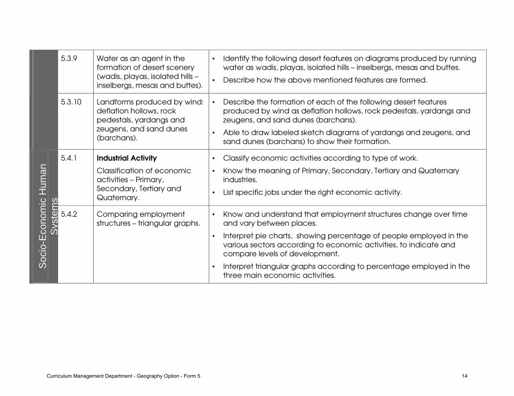
5.3.9 Water as an agent in the formation of desert scenery (wadis, playas, isolated hills – inselbergs, mesas and buttes).
• Identify the following desert features on diagrams produced by running water as wadis, playas, isolated hills – inselbergs, mesas and buttes.
• Describe how the above mentioned features are formed.
5.3.10 Landforms produced by wind: deflation hollows, rock pedestals, yardangs and zeugens, and sand dunes (barchans).
• Describe the formation of each of the following desert features produced by wind as deflation hollows, rock pedestals, yardangs and zeugens, and sand dunes (barchans).
• Able to draw labeled sketch diagrams of yardangs and zeugens, and sand dunes (barchans) to show their formation.
5.4.1 Industrial Activity
Classification of economic activities – Primary, Secondary, Tertiary and Quaternary.
• Classify economic activities according to type of work.
• Know the meaning of Primary, Secondary, Tertiary and Quaternary industries.
• List specific jobs under the right economic activity.
Soc
io-E
cono
mic
Hum
an
Sys
tem
s
5.4.2 Comparing employment structures – triangular graphs.
• Know and understand that employment structures change over time and vary between places.
• Interpret pie charts, showing percentage of people employed in the various sectors according to economic activities, to indicate and compare levels of development.
• Interpret triangular graphs according to percentage employed in the three main economic activities.
Curriculum Management Department - Geography Option - Form 5 14

5.4.3 Industry as a system: inputs, processes and outputs.
• Know and understand that industry or a factory can be regarded as a system with inputs, processes and outputs.
• Complete flow diagrams of a particular factory with examples of inputs, processes and outputs.
Soc
io-E
cono
mic
H
uman
5.4.4 Factors affecting industrial location. Footloose Industries.
• Appreciate that industrial location is determined by physical, human and economic factors.
• Realise that these locational factors can change over a period of time. Physical factors were more important in the past. Nowadays human and economic factors are more important.
• Know the meaning of the term footloose industries that have come about due to the development in the transport network.
Curriculum Management Department - Geography Option - Form 5 15

5.4.5 Industrial change – deindustrialisation (decline in primary and in manufacturing industries) – South Wales or the Rhine –Ruhr industrial region as an example.
• Know the meaning of the term deindustrialisation.
• Understand the reasons for the decline in primary and secondary industries including mechanisation and automation, lack of money for upgrading factories, competition from newly industialised countries producing similar products that are cheaper.
• Locate South Wales or the Rhine-Ruhr industrial region on a map of Europe.
• Locate the more important places connected with the industry on a map of the region of South Wales or the Rhine-Ruhr area.
• Account for the physical factors that contributed to the original development of industry in South Wales or the Rhine-Ruhr area.
• Understand the reasons for the decline in the chosen area.
• Know the contributing factors that led to the regeneration of industry within the chosen area.
5.4.6 High technology industry – the M4 corridor in the UK.
• Know the meaning of the terms high-tech industry, science and business parks.
• Know the factors encouraging the location of high-tech industry in the M4 corridor namely accessibility (transport), universities, cultural and social attractions, labour supply and attractive countryside.
Soc
io-E
cono
mic
Hum
an
Sys
tem
s
5.4.7 Multinational or transnational corporations (TNCs). Positive and negative impacts of TNCs.
• Define the terms multinational or transnational corporations (TNCs).
• Aware of the functions and scope of multinational or transnational corporations (TNCs).
• Identify some world renowned multinational corporations.
• Understand the advantages and disadvantages of TNCs.
Curriculum Management Department - Geography Option - Form 5 16

5.4.8 Global Industry. • Understand the meaning of the term globalisation.
5.4.9 Emergence of newly industrialised countries (NICs) – The Pacific Rim.
• Define the term NIC as Newly Industrialised Countries.
• Locate the newly industrialised countries of China, Indonesia, Malaysia, Philippines, Singapore, South Korea, Taiwan and Thailand on a map of Asia.
• Explain the reasons for the rapid economic growth of NICs of the Pacific Rim.
5.4.10 Case Study:
Industry in Osaka-Kobe conurbation.
• Locate Osaka-Kobe conurbation on a map of Japan.
• Identify the reasons for the industrial growth within this conurbation.
• Aware of the different sized companies which compose Japan’s industrial pyramid.
• Describe a particular important industry in the Osaka-Kobe area.
• Recognise the problems of the chosen industry and the attempted solutions.
Soc
io-E
cono
mic
Hum
an S
yste
ms
5.4.11 Case Study: Industry in São Paulo.
• Locate São Paulo on a map of South America.
• Account for the main features of São Paolo’s rapid economic growth including early industry and the nature of more recent industrial development.
• Distinguish between the formal and informal industrial sectors.
• Recognise the problems caused by this rapid industrial growth in São Paulo and the attempted solutions.
Curriculum Management Department - Geography Option - Form 5 17

5.4.12 World Development
The development gap; the North-South divide.
• Interpret a world map showing the North-South Divide.
• Know the meaning of LEDCs and MEDCs.
5.4.13 Measuring development – indicators of development – economic and social indicators e.g. GNP, mortality rate, life expectancy, literacy rate, housing, diet etc.).
• Define the meaning of the term Gross National Product and GNP per capita as the most common measure of economic wealth within a country.
• Aware of inequalities in GNP per capita in different areas of the same country.
• Define and understand the terms mortality rate, infant mortality, life expectancy and literacy rate.
• Explain how the following indicators as employment, housing, diet, health, education, population, energy and trade determine the actual standard of living.
Soc
io-E
cono
mic
Hum
an S
yste
ms
5.4.14 The Human Development Index (HDI).
• Understand the meaning of the Human Development Index (HDI) as a statistical measure of the quality of life adopted by the United Nations.
• Know the three components of HDI that is life expectancy (health), adult literacy (education), and real GNP per capita (standard of living).
• Analyse and evaluate HDI values for particular countries to compare quality of life.
Curriculum Management Department - Geography Option - Form 5 18

5.4.15 Causes and consequences of inequalities in world development.
• Identify the economic, social, political and environmental factors that lead to inequalities in development.
• Recognise the resultant factors caused by such inequalities including high birth and infant mortality rate, shorter life expectancy, poor education facilities, more jobs in informal sectors, small volume of trade and less purchasing power.
5.4.16 Trading blocs – tariffs and quotas – (EU, NAFTA, LAFTA, OPEC, ASEAN).
• Know the general aims and scope of trading blocs, tariffs and quotas.
• Aware that some countries have grouped together to form Trading Blocs.
• Know what the abbreviations of the Trading Blocs EU, NAFTA, LAFTA, OPEC, ASEAN stand for.
• Identify the world regions represented by the Trading Blocs above.
5.4.17 Types of aid: bilateral, multilateral, voluntary and emergency aid.
• Explain what is aid and why countries may need aid.
• Differentiate between three major kinds of aid money, goods and people.
• Classify types of aid including government bilateral or multilateral aid as well as non-governmental organisations (NGOs) which provide voluntary and emergency aid.
Soc
io-E
cono
mic
Hum
an S
yste
ms
5.4.18 The benefits and problems of aid.
• Recognise the advantages and disadvantages of each of the above mentioned types of aid.
Curriculum Management Department - Geography Option - Form 5 19
5.4.19 Case Study:
Countries with different levels of development.
Japan and Kenya.
• Analyse the differences in devolpment between Japan and Kenya.
• Differentiate between the main types of imports, exports, trading partners, trade balance and value of Japan and Kenya.
5.4.20 Difference within
countries: Italy
• Analyse in regards to development the advantages of Northern Italy and the disadvantages of the South known as the Mezzogiorno.
• Describe the nature of the economic improvements in the South of Italy.
5.5.1 Ecosystems
How an ecosystem works.
• Define the term ecosystem.
• Distinguish between micro, meso and global ecosystems giving most common examples.
• Identify the roles of flora, fauna, rocks and soils as components of an ecosystem.
• Aware of the interaction between the living and non living aspects of an ecosystem.
Env
ironm
enta
l Con
cern
s
5.5.2 Basic processes of an ecosystem: flow of energy and the recycling of nutrients.
• Understand the terms and functions of the food chain including producers, consumers (herbivores), consumers (carnivores), decomposers.
• Recognise the energy flow in a simple ecosystem through the process of photosynthesis and the food chain.
• Able to draw a simple labelled flow diagram to show the nutrient cycle within an ecosystem.
Curriculum Management Department - Geography Option - Form 5 20
5.5.3 Distribution of major world natural vegetation zones (biomes).
• Identify and locate on a world map the distribution of the following major natural vegetation zones (biomes): tropical rainforest, savanna, desert, Mediterranean, temperate deciduous, temperate grasslands, northern coniferous, and tundra.
5.5.4 Case Study:
Causes and effects of deforestation in the Amazon Rainforest.
• Locate the Amazon Rainforest on a map of South America.
• Define the term deforestation.
• List the main reasons for deforestation within the Amazon Rainforest including shifting agriculture (slash and burn), subsistence farming, cattle ranching, hydro electric power schemes, mining, logging, new roads, and settlements.
• Recognise the following effects of forest clearance in Brazil namely loss of species and forest ecosystem, reduction of Amerindians and loss of their traditional culture, less rainfall in the region , soil erosion, soil infertility and Global Warming.
Env
ironm
enta
l Con
cern
s
5.5.5 Sustainable Forestry. • Understand the term sustainable forestry.
• Aware of how the forest can be managed to ensure sustainability by protection of forest, creation of national parks, controlled and selective logging, heli-logging, replanting of forested areas that have been felled and restriction of logging licences.
Curriculum Management Department - Geography Option - Form 5 21

5.5.6 Case Study: Desertification in the Sahel
• Define the term desertification.
• Locate the countries within the Sahel Region on a map of Africa including Ethiopia, Sudan, Chad, Niger and Somalia.
• Classify the natural and human causes leading to desertifiaction including decrease in rainfall, effects of global warming, overgrazing, overcultivation and population growth.
• Analyse how the growth of population in the Sahel results in overgrazing, overcultivation and deforestation which lead to desertification.
• Aware of the possible solutions to stop the desert from advancing.
5.5.7 Destruction of the natural vegetation by deforestation, grazing animals and fire.
• Consolidate how deforestation is a major cause of desertification.
Loca
tion
and
5.6.1 Location of deserts: Californian, Arizona, Atacama, Sahara, Namib, Kalahari, Arabian, Thar, Gobi, Australian.
• Know the position of and locate on a world map the following deserts, Californian, Arizona, Atacama, Sahara, Namib, Kalahari, Arabian, Thar, Gobi, Australian
Curriculum Management Department - Geography Option - Form 5 22

5.6.2 Distribution of major world biomes:
Tundra, Taiga (coniferous forests), Temperate
deciduous forests, Temperate Grasslands, Mediterranean, Hot Desert, Tropical
Rainforests, Savanna Grasslands.
• Identify the following major biomes on a map of the world: Tundra, Taiga (coniferous forests), Temperate deciduous forests, Temperate Grasslands, Mediterranean, Hot Desert, Tropical Rainforests, Savanna Grasslands.
Loca
tion
and
Pla
ces
5.6.3 The location of these major ports:
Vancouver, Seattle, San Francisco, Los Angeles,
New York, Caracas, Rio de Janeiro, São Paulo, Buenos Aires, Rotterdam, Antwerp, Barcellona, Marseilles, Trieste, Genoa, Valletta, Istanbul, Port Said, Cape Town, Mumbai, Madras, Singapore, Hong Kong, Shangai, Tokyo, Osaka-Kobe, Sydney, Melbourne.
Know the position of and locate the following major ports on a world map: Vancouver, Seattle, San Francisco, Los Angeles, New York, Caracas, Rio de Janeiro, São Paulo, Buenos Aires, Rotterdam, Antwerp, Barcellona, Marseilles, Trieste, Genoa, Valletta, Istanbul, Port Said, Cape Town, Mumbai, Madras, Singapore, Hong Kong, Shangai, Tokyo, Osaka-Kobe, Sydney, Melbourne.
Curriculum Management Department - Geography Option - Form 5 23
5.6.4 Location of the following ice covered areas:
Antarctica, Greenland, Iceland, Spitzbergen, Bearing Sea, Baltic Sea, White Sea.
• Identify the following ice covered areas on a world map namely Antarctica, Greenland, Iceland, Spitzbergen, Bearing Sea, Baltic Sea, White Sea.
Curriculum Management Department - Geography Option - Form 5 24

Annexe 1 The Annual Examination Papers The examination will consist of one paper of 1 hour 45 minutes duration. Papers will be set in English and candidates are expected to answer in good English. The use of non-programmable calculators, geometrical instruments, pencil colours, piece of string and blank sheet of paper for calculating curved distances on Topographic Maps is permitted during the examination. Exam papers of each Form will reflect the topics covered as indicated by the present document. However, in regards to Map Reading and Interpretation the exam papers for Forms 4 and 5 will also refer to the topics covered during the previous years. The exam papers for Forms 3 ,4 and 5 are prepared by the Education Assessment Unit at the Directorate for Quality and Standards in Education and will carry a maximum of 90 marks consisting of nine structured questions as indicated in the table below. The remaining 10 marks will be awarded for the fieldwork according to the set criteria in the syllabus.
Strands No. of questions
Marks
Map Reading and Interpretation 1 12
Location and Places 1 8
Weather and Climate 1 12
Landforms and Processes 2 20
Socio-Economic Human Systems 2 20
Environmental Concerns 2 18
Total: 90
Teachers are encouraged to follow this format in the setting of their school based half yearly examinations.
Curriculum Management Department - Geography Option - Form 5 25

Annexe 2 Priorities for Forms 5 The following are the areas of study which should be given priority for the Annual Examination for Forms 5 which is held during the month of February.
5.1 Map reading and Interpretation 5.1.1, 5.1.2, 5.1.3
5.2 Weather and Climate 5.2.1, 5.2.2, 5.2.3, 5.2.4, 5.2.5, 5.2.7
5.3 Landforms and Processes 5.3.1, 5.3.2, 5.3.3, 5.3.4, 5.3.5, 5.3.6
5.4 Socio-Economic Human Systems 5.4.1, 5.4.2, 5.4.3, 5.4.4, 5.4.5, 5.4.6, 5.4.7, 5.4.8, 5.4.9,
5.4.10, 5.4.11
5.5 Environmental Concerns 5.5.1, 5.5.2, 5.5.3, 5.5.4, 5.5.5
5.6 Location and Places 5.6.2 5.6.3, 5.6.4
The rest of the syllabus then needs to be covered for SEC examination purposes.
Curriculum Management Department - Geography Option - Form 5 26

Annexe 3
Sample Annual Exam Paper
Curriculum Management Department - Geography Option - Form 5 27

Geography Option – Secondary Form 5 – Sample Paper Page 1 of 10
DIRECTORATE FOR QUALITY AND STANDARDS IN EDUCATION
Department for Curriculum Management
Educational Assessment Unit
Annual Examinations for Secondary Schools Sample Paper
FORM 5 GEOGRAPHY (Option) TIME: 1h 45min
Name: _____________________________________ Class: _______________
Instructions to Candidates
Answer all questions in the space provided. Write your answers neatly and in good English. Credit
will be given for relevant illustrations. The marks for individual questions are shown in round
brackets: e.g. (4). There are 7 questions in all. The total mark for this paper is 90. The use of blank
paper, pieces of string and calculators is allowed.
Examiner’s use only
Question No.
1 2 3 4 5 6 7 Written Exam
Fieldwork
Report
Total
Max. Mark 12 8 12 10 10 20 18 90 10 100
Score
1. Study carefully figure 1 (on page 2) – Malta East extract and then choose the right word from
the brackets. The scale of the map is 1:25000 or 4cm:1km.
a. Balzan church in 505730 is to the (North-west, North-east, South, West) of Attard school
in grid reference 497723. (1)
b. S. Anton Palace and Gardens are in grid square (5072, 5071, 4971, 5172). (1)
c. What is the 6-figure grid reference of Tal-Ħlas chapel?
________________________________ (1)
d. The straight line distance from Żebbuġ church in 497700 to Ta’ Srina roundabout at
494708 is (875, 1075, 675, 475) metres. (1)
e. What is the distance in kilometres along the road between Ta’ Srina roundabout at 494708
and Attard school at 496722?
________________________________ (2)

Geography Option – Secondary Form 5 – Sample Paper Page 2 of 10
49 50 51 52

Geography Option – Secondary Form 5 – Sample Paper Page 3 of 10
f. Judging by the shape of the contour lines, does the watercourse at Wied is-Sewda in grid
squares 4971, 5071 and 5171 flow towards west, east or South?
________________________________ (1)
g. What would you say is the major industry or occupation in the following grid squares?
4971 ________________________________
5071 ________________________________ (2)
h. One can notice many types of street and building patterns in the towns of this map. What
types can be seen in the following areas? Choose from:
winding and narrow streets, villas, grid pattern
west part of grid square 5173 ___________________________________ (1)
east part of grid square 5173 ___________________________________ (1)
west part of grid square 4972 ___________________________________ (1)
2. Look at figure 2 on page 3 showing the world map and then name the following:
a. major winter ice-caps - Choose from:
Baltic Sea, White Sea, Antarctica, Iceland
A B
C D
b. major ports
1 2
3 4
(8)

Geography Option – Secondary Form 5 – Sample Paper Page 4 of 10
Geography Option – Secondary Form 5 – Sample Paper Page 5 of 10
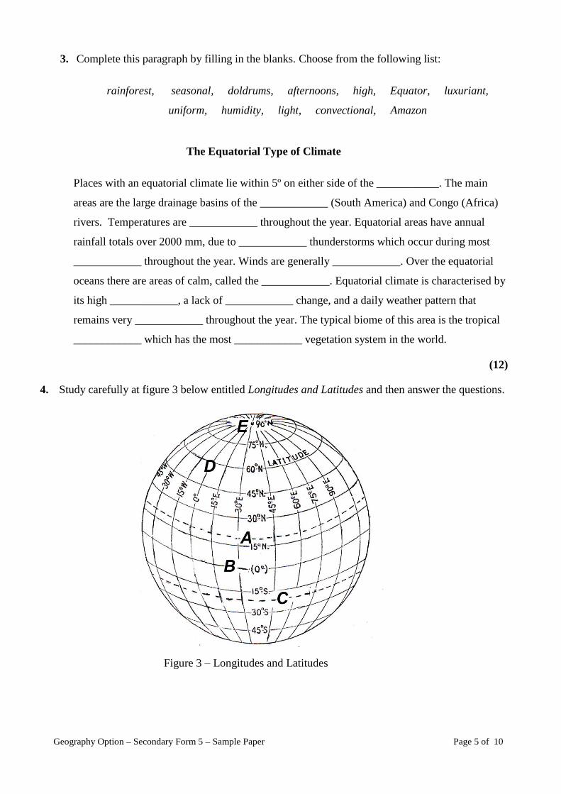
3. Complete this paragraph by filling in the blanks. Choose from the following list:
rainforest, seasonal, doldrums, afternoons, high, Equator, luxuriant,
uniform, humidity, light, convectional, Amazon
The Equatorial Type of Climate
Places with an equatorial climate lie within 5º on either side of the ___________. The main
areas are the large drainage basins of the ____________ (South America) and Congo (Africa)
rivers. Temperatures are ____________ throughout the year. Equatorial areas have annual
rainfall totals over 2000 mm, due to ____________ thunderstorms which occur during most
____________ throughout the year. Winds are generally ____________. Over the equatorial
oceans there are areas of calm, called the ____________. Equatorial climate is characterised by
its high ____________, a lack of ____________ change, and a daily weather pattern that
remains very ____________ throughout the year. The typical biome of this area is the tropical
____________ which has the most ____________ vegetation system in the world.
(12)
4. Study carefully at figure 3 below entitled Longitudes and Latitudes and then answer the questions.
Figure 3 – Longitudes and Latitudes

Geography Option – Secondary Form 5 – Sample Paper Page 6 of 10
a. Name the lines of latitude marked:
A ___________________________
B ___________________________
C ___________________________
b. Name the line of longitude D. ___________________________
c. Name the place E. ___________________________
d. What are the lines such as 90º E called? ___________________________
e. What is another name for 180º longitude approximately? ___________________________
f. Which is the longest line of latitude? ___________________________
g. Apart from showing the position of a place what are lines of longitude used for?
____________________________________________________________________________
____________________________________________________________________________
h. Which line of latitude has equal days and nights throughout the year?
____________________________________________________________________________
(10)
5. a. Complete the diagram in figure 4, below, by filling in the blanks to show a glacier system.
Choose from the following list.
ice, accumulation, ablation, evaporation, snow, meltwater (6)
Figure 4 – A Glacier System
Geography Option – Secondary Form 5 – Sample Paper Page 7 of 10
b. The two main processes of glacial erosion are abrasion and plucking.
Describe these two processes:
i. Abrasion
__________________________________________________________________________
__________________________________________________________________________
_________________________________________________________________________ (2)
ii. Plucking
__________________________________________________________________________
__________________________________________________________________________
_________________________________________________________________________ (2)
6. Answer the following questions.
a. Define the term transnational corporation.
__________________________________________________________________________
__________________________________________________________________________
_________________________________________________________________________ (2)
b. Give another name for transnational corporation.
_________________________________________________________________________ (2)
c. Give one type of industry or economic activity that has many transnational corporations.
_________________________________________________________________________ (2)
d. Give the name of one such transnational corporation or company.
_________________________________________________________________________ (2)

Geography Option – Secondary Form 5 – Sample Paper Page 8 of 10
e. Give two advantages of having transnational corporations in one’s own country.
__________________________________________________________________________
__________________________________________________________________________
_________________________________________________________________________ (4)
f. Give two disadvantages of having transnational corporations in one’s own country.
__________________________________________________________________________
__________________________________________________________________________
_________________________________________________________________________ (4)
g. Give one reason why a car manufacturer may choose to become a transnational corporation and
operate in many countries. .
__________________________________________________________________________
_________________________________________________________________________ (2)
h. What is meant by Newly Industrialising Countries?
__________________________________________________________________________
_________________________________________________________________________ (2)
7. Study the diagram of a Food Web in figure 5 on page 9.
a. Complete the following paragraph using the words provided.
photosynthesis organisms food sunlight
chemicals food chain
Ecosystems obtain their energy from _______________. Green plants trap solar energy and use
it to convert simple _______________ into _______________. This process is called
_______________. The energy then flows along the _______________ by passing through the
_______________ which live within the ecosystem.
(6)

Geography Option – Secondary Form 5 – Sample Paper Page 9 of 10
Figure 5 – A Food Web
b. Underline the correct answer in the brackets.
i. What is a herbivore? An animal or insect that eats (other animals, plants, fish, algae).
ii. Underline two herbivores. (lion, cat, insects, antelope, snake)
iii. What is a carnivore? An animal that eats (other animals, plants, pasta, seaweed).
iv. Underline two carnivores. (cat, antelope, horse, eagle, cow) (6)
c. Answer the following questions.
i. In any food chain, top consumers are often referred to as predators. Explain what this
means.
_________________________________________________________________________
_________________________________________________________________________
_________________________________________________________________________
_________________________________________________________________________
(2)

Geography Option – Secondary Form 5 – Sample Paper Page 10 of 10
ii. Give one example of a decomposer.
___________________________ (1)
iii. Describe the part played by decomposers in a food chain.
_________________________________________________________________________
_________________________________________________________________________
_________________________________________________________________________
_________________________________________________________________________
(3)
Top Related