


Languages
Pages
Legal

_____________________________________________________________________________
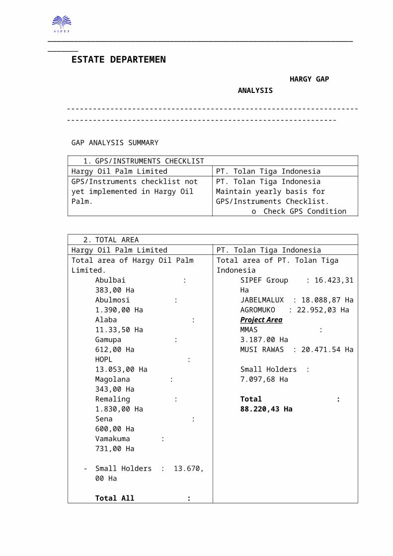
ESTATE DEPARTEMEN
HARGY GAP ANALYSIS
---------------------------------------------------------------------------------------------------------------------------------
GAP ANALYSIS SUMMARY
1. GPS/INSTRUMENTS CHECKLISTHargy Oil Palm Limited PT. Tolan Tiga IndonesiaGPS/Instruments checklist not yet implemented in Hargy Oil Palm.
PT. Tolan Tiga Indonesia Maintain yearly basis for GPS/Instruments Checklist.
o Check GPS Condition
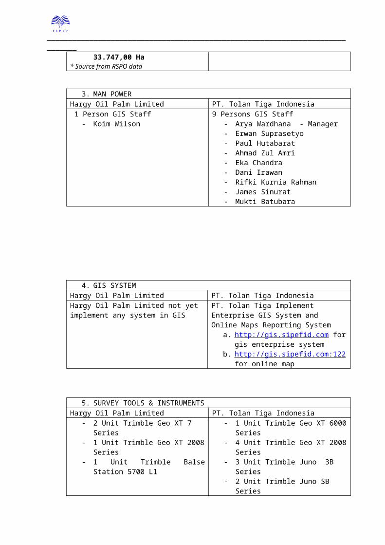
2. TOTAL AREAHargy Oil Palm Limited PT. Tolan Tiga IndonesiaTotal area of Hargy Oil Palm Limited.
Abulbai : 383,00 HaAbulmosi : 1.390,00 HaAlaba : 11.33,50 HaGamupa : 612,00 HaHOPL : 13.053,00 HaMagolana : 343,00 HaRemaling : 1.830,00 HaSena : 600,00 HaVamakuma : 731,00 Ha
- Small Holders : 13.670, 00 Ha
Total All : 33.747,00 Ha* Source from RSPO data
Total area of PT. Tolan Tiga IndonesiaSIPEF Group : 16.423,31 HaJABELMALUX : 18.088,87 HaAGROMUKO : 22.952,03 HaProject AreaMMAS : 3.187.00 HaMUSI RAWAS : 20.471.54 Ha
Small Holders : 7.097,68 Ha
Total : 88.220,43 Ha
3. MAN POWERHargy Oil Palm Limited PT. Tolan Tiga Indonesia 1 Person GIS Staff
- Koim Wilson9 Persons GIS Staff
- Arya Wardhana - Manager- Erwan Suprasetyo- Paul Hutabarat- Ahmad Zul Amri- Eka Chandra- Dani Irawan- Rifki Kurnia Rahman- James Sinurat- Mukti Batubara
_____________________________________________________________________________
4. GIS SYSTEMHargy Oil Palm Limited PT. Tolan Tiga IndonesiaHargy Oil Palm Limited not yet implement any system in GIS
PT. Tolan Tiga Implement Enterprise GIS System and Online Maps Reporting System
a. http://gis.sipefid.com for gis enterprise system
b. http://gis.sipefid.com:122 for online map
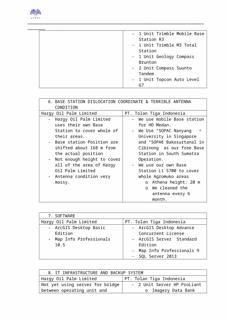
5. SURVEY TOOLS & INSTRUMENTSHargy Oil Palm Limited PT. Tolan Tiga Indonesia
- 2 Unit Trimble Geo XT 7 Series- 1 Unit Trimble Geo XT 2008 Series- 1 Unit Trimble Balse Station 5700 L1
- 1 Unit Trimble Geo XT 6000 Series- 4 Unit Trimble Geo XT 2008 Series- 3 Unit Trimble Juno 3B Series- 2 Unit Trimble Juno SB Series- 1 Unit Trimble Mobile Base Station R3- 1 Unit Trimble M3 Total Station- 1 Unit Geology Compass Brunton- 2 Unit Compass Suunto Tandem- 1 Unit Topcon Auto Level G7
6. BASE STATION DISLOCATION COORDINATE & TERRIBLE ANTENNA CONDITIONHargy Oil Palm Limited PT. Tolan Tiga Indonesia
- Hargy Oil Palm Limited uses their own Base Station to cover whole of their areas.
- Base station Position are shifted about 168 m from the actual position
- Not enough height to cover all of the area of Hargy Oil Palm Limited
- Antenna condition very mossy.
- We use mobile Base station for HO Medan.
- We Use “SOPAC Nanyang University in Singapore” and “SOPAC Bakosurtanal in Cibinong” as our free Base Station in South Sumatra Operation.
- We use our own Base Station L1 5700 to cover whole Agromuko areas
o Athena height: 20 mo We cleaned the antenna every
6 month.
7. SOFTWAREHargy Oil Palm Limited PT. Tolan Tiga Indonesia
- ArcGIS Desktop Basic Edition- Map Info Professionals 10.5
- ArcGIS Desktop Advance Concurrent License
- ArcGIS Server Standard Edition- Map Info Professionals 9- SQL Server 2013
_____________________________________________________________________________
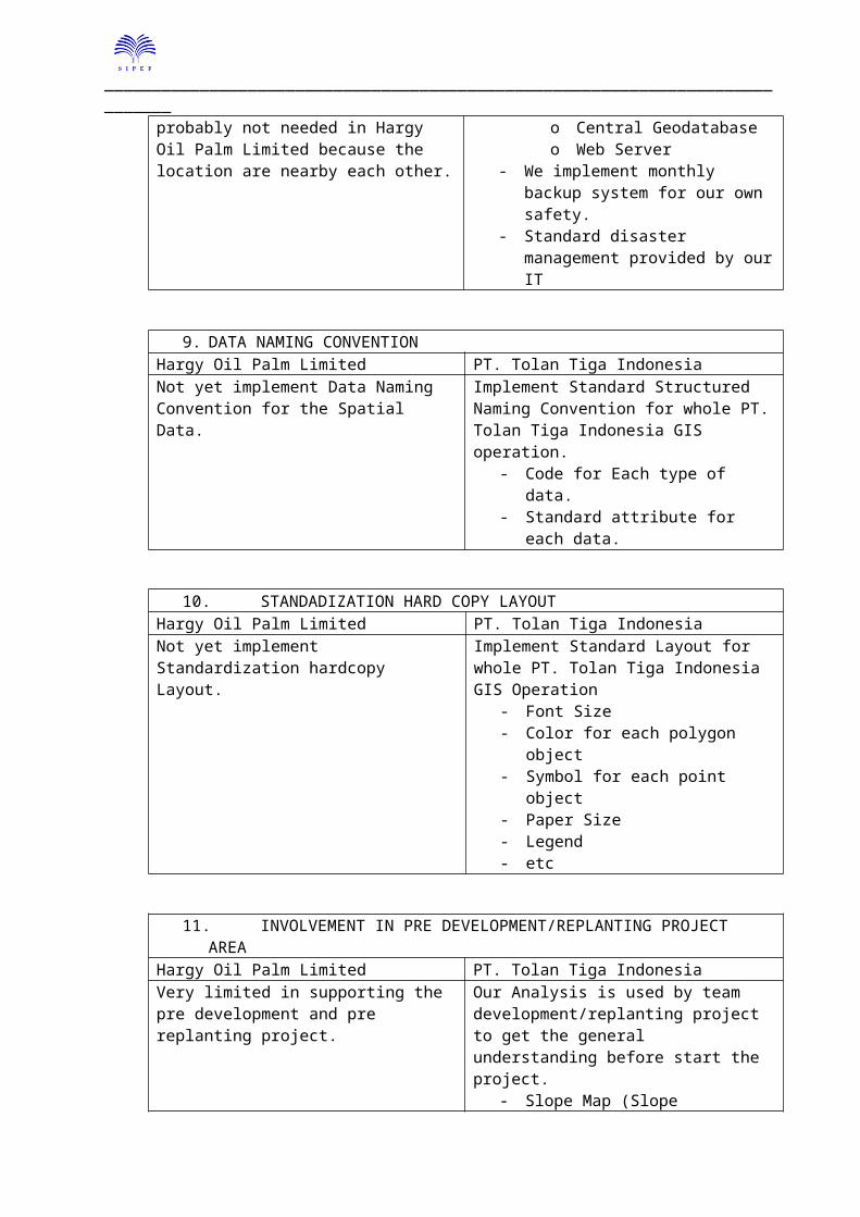
8. IT INFRASTRUCTURE AND BACKUP SYSTEMHargy Oil Palm Limited PT. Tolan Tiga IndonesiaNot yet using server for bridge between operating unit and probably not needed in Hargy Oil Palm Limited because the location are nearby each other.
- 2 Unit Server HP ProLianto Imagery Data Banko Central Geodatabaseo Web Server
- We implement monthly backup system for our own safety.
- Standard disaster management provided by our IT
9. DATA NAMING CONVENTIONHargy Oil Palm Limited PT. Tolan Tiga IndonesiaNot yet implement Data Naming Convention for the Spatial Data.
Implement Standard Structured Naming Convention for whole PT. Tolan Tiga Indonesia GIS operation.
- Code for Each type of data.- Standard attribute for each data.
10. STANDADIZATION HARD COPY LAYOUTHargy Oil Palm Limited PT. Tolan Tiga IndonesiaNot yet implement Standardization hardcopy Layout.
Implement Standard Layout for whole PT. Tolan Tiga Indonesia GIS Operation
- Font Size- Color for each polygon object- Symbol for each point object- Paper Size- Legend- etc
11. INVOLVEMENT IN PRE DEVELOPMENT/REPLANTING PROJECT AREAHargy Oil Palm Limited PT. Tolan Tiga IndonesiaVery limited in supporting the pre development and pre replanting project.
Our Analysis is used by team development/replanting project to get the general understanding before start the project.
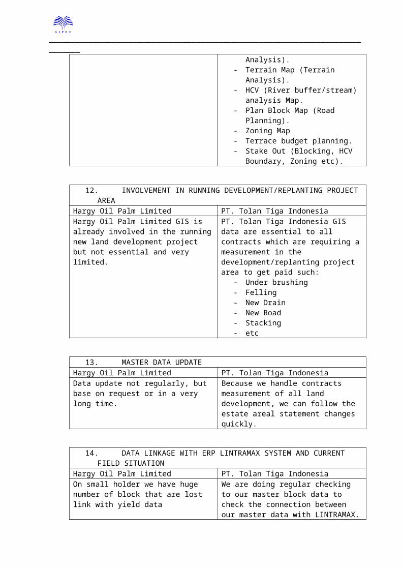
- Slope Map (Slope Analysis).- Terrain Map (Terrain Analysis).- HCV (River buffer/stream) analysis
Map.- Plan Block Map (Road Planning).- Zoning Map- Terrace budget planning.- Stake Out (Blocking, HCV Boundary,
Zoning etc).
12. INVOLVEMENT IN RUNNING DEVELOPMENT/REPLANTING PROJECT AREA
_____________________________________________________________________________
Hargy Oil Palm Limited PT. Tolan Tiga IndonesiaHargy Oil Palm Limited GIS is already involved in the running new land development project but not essential and very limited.
PT. Tolan Tiga Indonesia GIS data are essential to all contracts which are requiring a measurement in the development/replanting project area to get paid such:
- Under brushing- Felling- New Drain- New Road- Stacking- etc
13. MASTER DATA UPDATEHargy Oil Palm Limited PT. Tolan Tiga IndonesiaData update not regularly, but base on request or in a very long time.
Because we handle contracts measurement of all land development, we can follow the estate areal statement changes quickly.
14. DATA LINKAGE WITH ERP LINTRAMAX SYSTEM AND CURRENT FIELD SITUATIONHargy Oil Palm Limited PT. Tolan Tiga IndonesiaOn small holder we have huge number of block that are lost link with yield data
In the Plantations some of block still not yet link to LINTRAMAX.
We are doing regular checking to our master block data to check the connection between our master data with LINTRAMAX.
Some of Plantation block data also lost link with LINTRAMAX.
_____________________________________________________________________________
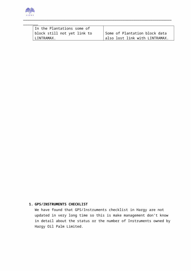
1. GPS/INSTRUMENTS CHECKLISTWe have found that GPS/Instruments checklist in Hargy are not updated in very long time so this is make management don’t know in detail about the status or the number of Instruments owned by Hargy Oil Palm Limited.
GPS/Instruments checklist very important to the management especially someone who responsible in GIS to manage their tools and detects GPS Conditions, (if possible with photograph).
This is the status of Hargy Oil Palm Limited Surveying Instruments
No Type Name Unit User Status Location1 GPS Trimble GeoXT 7 Series 2 Koim Wilson Good Condition Hargy2 GPS Trimble GeoXT 2008 Series 1 Koim Wilson Broken Condition Hargy3 Base Trimble L1 5700 Base Station 1 Koim Wilson Software Error Hargy
In PT. Tolan Tiga Indonesia normally every region, submits their GPS/Instrument status in yearly period.And every broken GPS should attach the “News Event Letter” so we can know the cause.
_____________________________________________________________________________
Picture 01
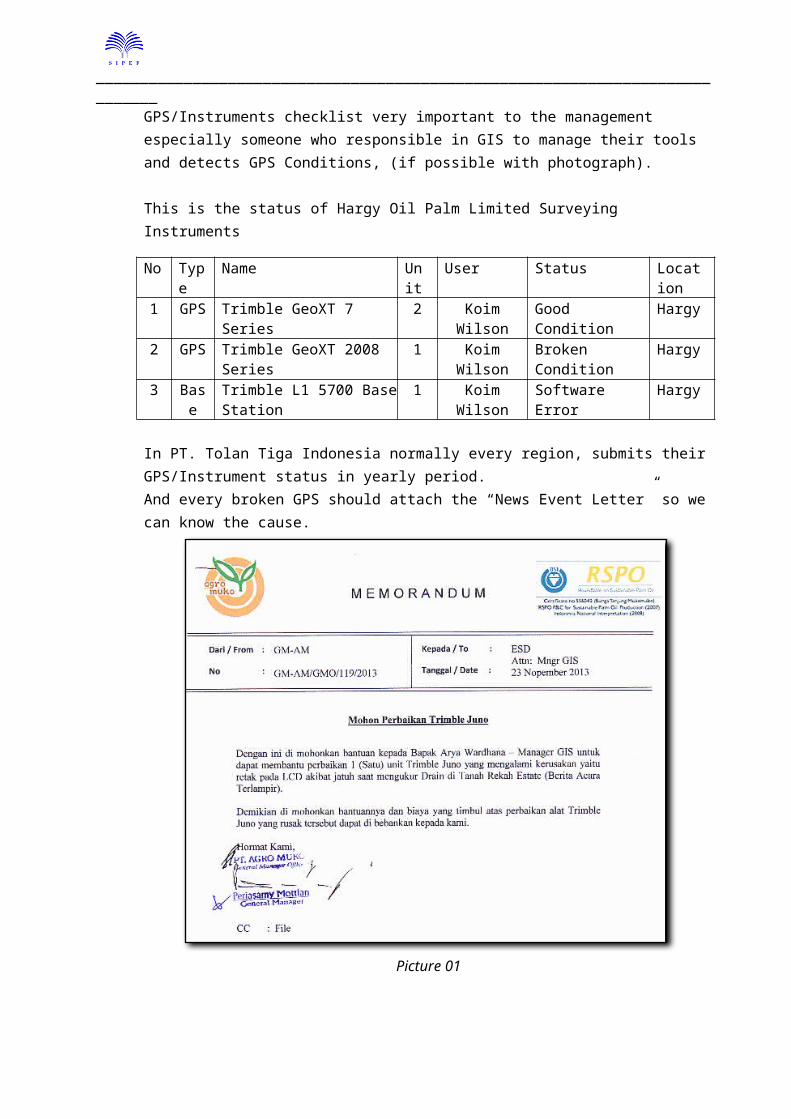
2. TOTAL AREA Total Covered Area in Hargy Oil Palm Limited now has become bigger with new development in Pandi Estate nearly 5.000 Hectare.
We have doing a simple calculation comparing between the GPS data and the Statement Area and we have quite big difference, this is the detail:
_____________________________________________________________________________
Picture 02
From the data, we found that there are some location showing a quite big difference between data GPS and the Statement Area such:
1. Hargy Oil Palm = 31.83 Ha2. Magolana Estate = 37.64 Ha3. Remaling Project = 946.97 Ha
We suggest doing some verification to the location which is having big variance to find the actual figures.
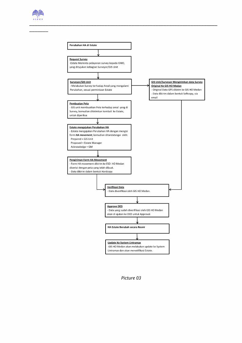
In PT. Tolan Tiga Indonesia, we lock the LINTRAMAX hectare, only GIS can change the hectare, this is to avoid inconsistency hectare figures between GIS and the LINTRAMAX System. So every changes should included the GPS data, then only with that we can process the changes.
Chart of how to change the LINTRAMAX Hectare: (in Bahasa)
_____________________________________________________________________________
Picture 03
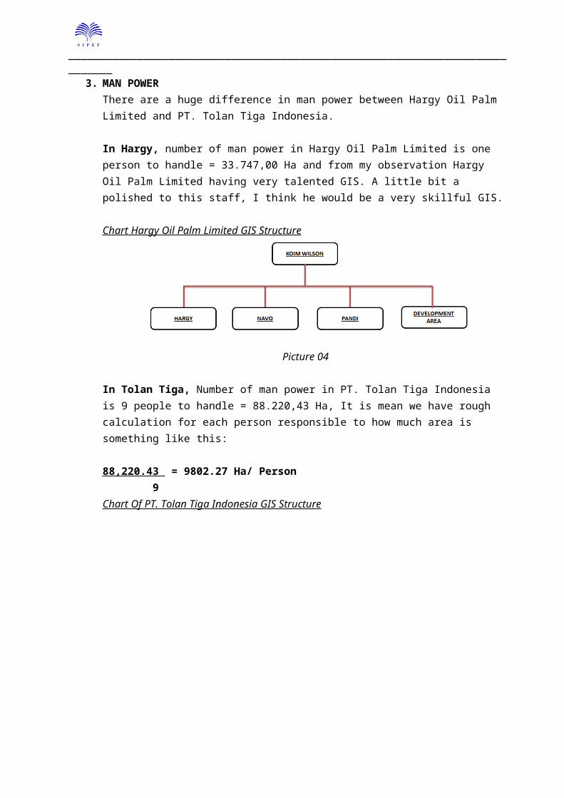
3. MAN POWER
_____________________________________________________________________________
There are a huge difference in man power between Hargy Oil Palm Limited and PT. Tolan Tiga Indonesia.
In Hargy, number of man power in Hargy Oil Palm Limited is one person to handle = 33.747,00 Ha and from my observation Hargy Oil Palm Limited having very talented GIS. A little bit a polished to this staff, I think he would be a very skillful GIS.
Chart Hargy Oil Palm Limited GIS Structure
Picture 04
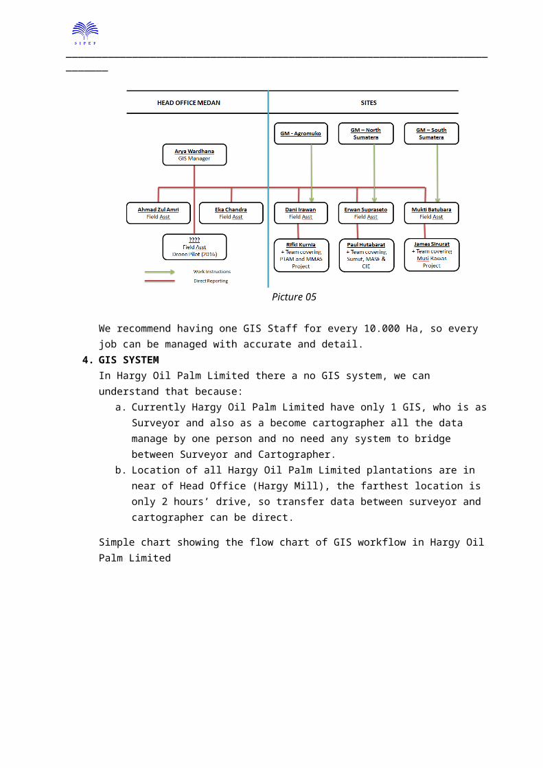
In Tolan Tiga, Number of man power in PT. Tolan Tiga Indonesia is 9 people to handle = 88.220,43 Ha, It is mean we have rough calculation for each person responsible to how much area is something like this:
88,220.43 = 9802.27 Ha/ Person 9Chart Of PT. Tolan Tiga Indonesia GIS Structure
Picture 05
We recommend having one GIS Staff for every 10.000 Ha, so every job can be managed with accurate and detail.
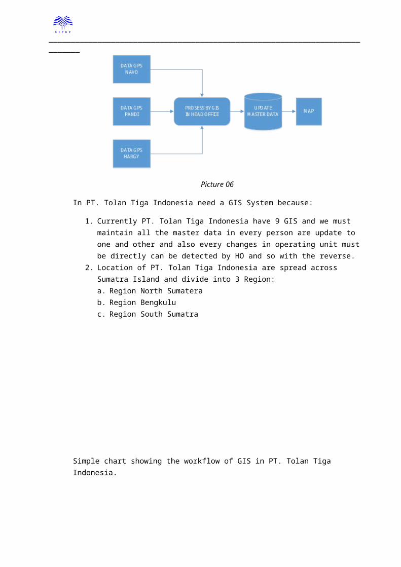
4. GIS SYSTEM
_____________________________________________________________________________
In Hargy Oil Palm Limited there a no GIS system, we can understand that because: a. Currently Hargy Oil Palm Limited have only 1 GIS, who is as Surveyor and also as a
become cartographer all the data manage by one person and no need any system to bridge between Surveyor and Cartographer.
b. Location of all Hargy Oil Palm Limited plantations are in near of Head Office (Hargy Mill), the farthest location is only 2 hours’ drive, so transfer data between surveyor and cartographer can be direct.
Simple chart showing the flow chart of GIS workflow in Hargy Oil Palm Limited
Picture 06
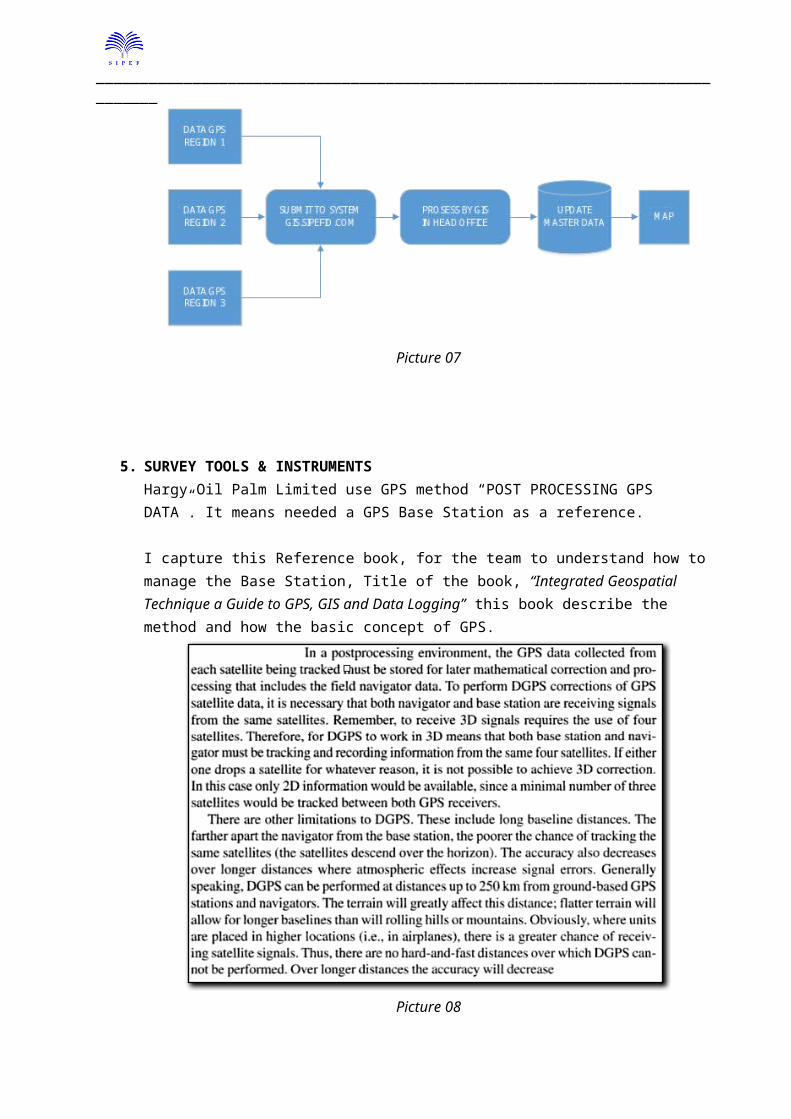
In PT. Tolan Tiga Indonesia need a GIS System because:
1. Currently PT. Tolan Tiga Indonesia have 9 GIS and we must maintain all the master data in every person are update to one and other and also every changes in operating unit must be directly can be detected by HO and so with the reverse.
2. Location of PT. Tolan Tiga Indonesia are spread across Sumatra Island and divide into 3 Region:a. Region North Sumatera b. Region Bengkulu c. Region South Sumatra
_____________________________________________________________________________
Simple chart showing the workflow of GIS in PT. Tolan Tiga Indonesia.
Picture 07
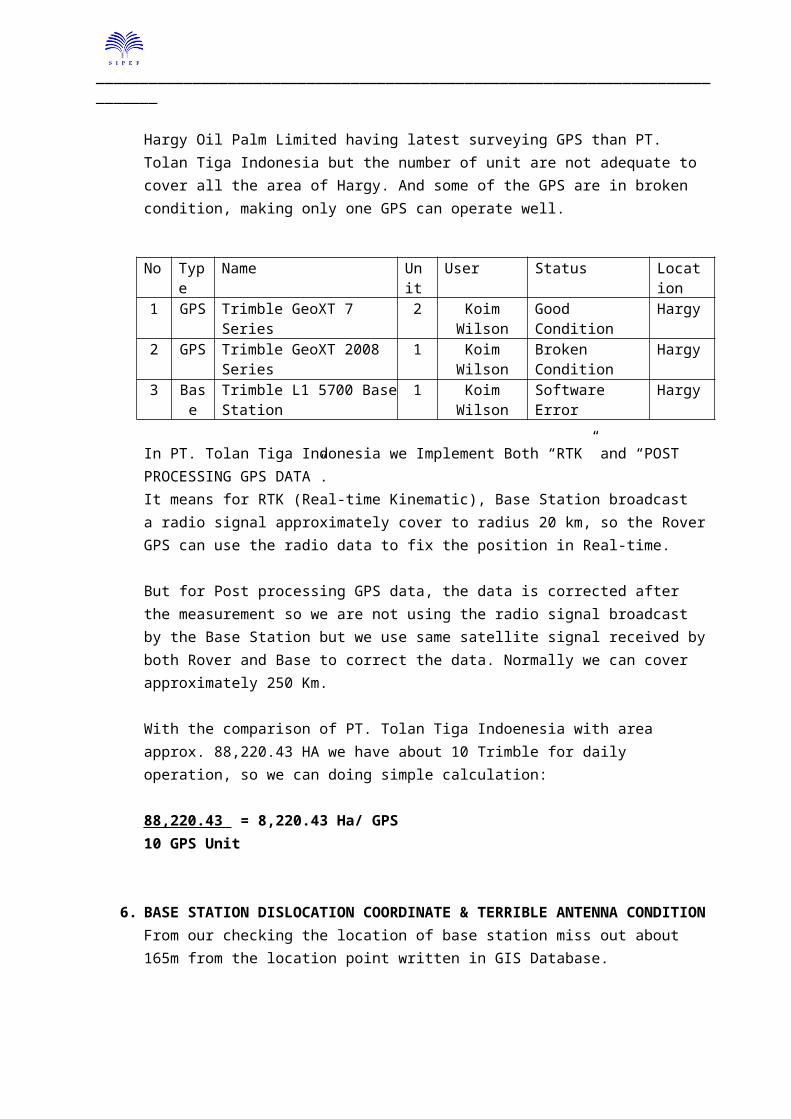
5. SURVEY TOOLS & INSTRUMENTSHargy Oil Palm Limited use GPS method “POST PROCESSING GPS DATA”. It means needed a GPS Base Station as a reference.
I capture this Reference book, for the team to understand how to manage the Base Station, Title of the book, “Integrated Geospatial Technique a Guide to GPS, GIS and Data Logging” this book describe the method and how the basic concept of GPS.
Picture 08
_____________________________________________________________________________
Hargy Oil Palm Limited having latest surveying GPS than PT. Tolan Tiga Indonesia but the number of unit are not adequate to cover all the area of Hargy. And some of the GPS are in broken condition, making only one GPS can operate well.
No Type Name Unit User Status Location1 GPS Trimble GeoXT 7 Series 2 Koim Wilson Good Condition Hargy2 GPS Trimble GeoXT 2008 Series 1 Koim Wilson Broken Condition Hargy3 Base Trimble L1 5700 Base Station 1 Koim Wilson Software Error Hargy
In PT. Tolan Tiga Indonesia we Implement Both “RTK” and “POST PROCESSING GPS DATA”.It means for RTK (Real-time Kinematic), Base Station broadcast a radio signal approximately cover to radius 20 km, so the Rover GPS can use the radio data to fix the position in Real-time. But for Post processing GPS data, the data is corrected after the measurement so we are not using the radio signal broadcast by the Base Station but we use same satellite signal received by both Rover and Base to correct the data. Normally we can cover approximately 250 Km.
With the comparison of PT. Tolan Tiga Indoenesia with area approx. 88,220.43 HA we have about 10 Trimble for daily operation, so we can doing simple calculation:
88,220.43 = 8,220.43 Ha/ GPS10 GPS Unit
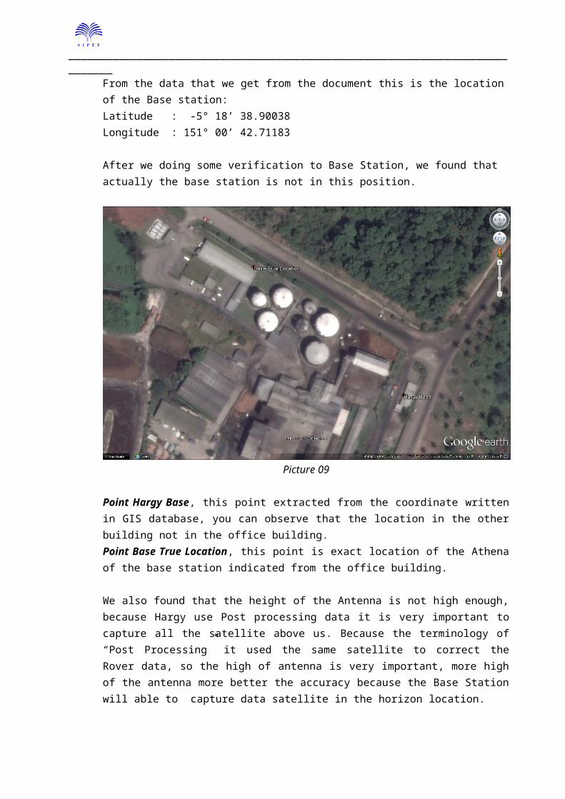
6. BASE STATION DISLOCATION COORDINATE & TERRIBLE ANTENNA CONDITIONFrom our checking the location of base station miss out about 165m from the location point written in GIS Database.
From the data that we get from the document this is the location of the Base station:Latitude : -5° 18’ 38.90038Longitude : 151° 00’ 42.71183
After we doing some verification to Base Station, we found that actually the base station is not in this position.
_____________________________________________________________________________
Picture 09
Point Hargy Base, this point extracted from the coordinate written in GIS database, you can observe that the location in the other building not in the office building.Point Base True Location, this point is exact location of the Athena of the base station indicated from the office building.
We also found that the height of the Antenna is not high enough, because Hargy use Post processing data it is very important to capture all the satellite above us. Because the terminology of “Post Processing” it used the same satellite to correct the Rover data, so the high of antenna is very important, more high of the antenna more better the accuracy because the Base Station will able to capture data satellite in the horizon location. The Hargy Base Station antenna looks very dirty and very mossy.
In PT. Tolan Tiga Indonesia in Agromuko we use 16m High from the Land and about 35m above the sea level, since there is no big mountain around us, and we do cleaning for the GPS antenna every 6 month.For the other location of PT. Tolan Tiga Indonesia we use free Base Station Data
1. SOPAC Nanyang University in SInagpore.2. SPOCA Bakosurtanal in Cibinong Indoensia.
_____________________________________________________________________________
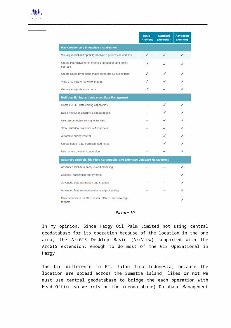
7. SOFTWAREArcGIS DesktopSince Hargy Oil Palm Limited also moved to ArcGIS Desktop, so we don’t talk about other software except ArcGIS Desktop, we try to explore the differences between ArcGIS license in Hargy Oil Palm Limited and PT. Tolan Tiga Indonesia
Hargy Oil Palm Limited Use ArcGIS desktop Basic Edition (ArcView) and PT. Tolan Tiga Indonesia Use ArcGIS Desktop Advance Edition (ArcInfo).
The difference between license are shown on the table below.
Picture 10
In my opinion, Since Hargy Oil Palm Limited not using central geodatabase for its operation because of the location in the one area, the ArcGIS Desktop Basic (ArcView) supported with the ArcGIS extension, enough to do most of the GIS Operational in Hargy.
_____________________________________________________________________________
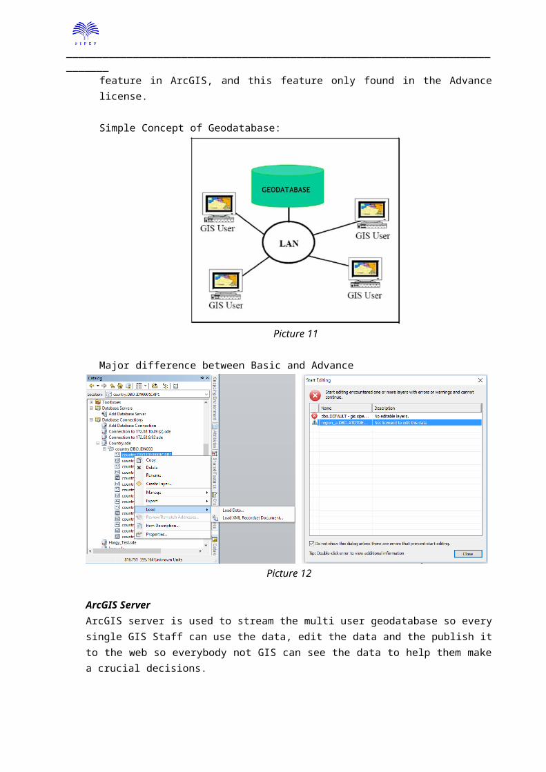
The big difference in PT. Tolan Tiga Indonesia, because the location are spread across the Sumatra island, likes or not we must use central geodatabase to bridge the each operation with Head Office so we rely on the (geodatabase) Database Management feature in ArcGIS, and this feature only found in the Advance license.
Simple Concept of Geodatabase:
Picture 11
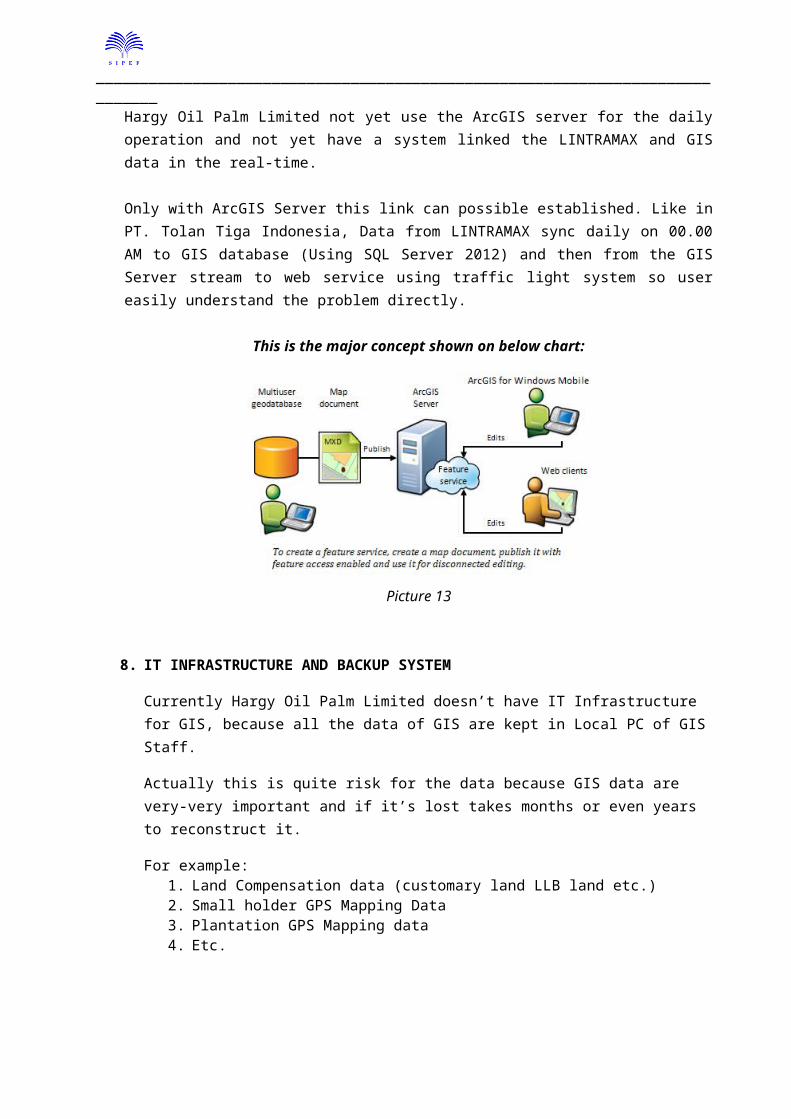
Major difference between Basic and Advance
Picture 12
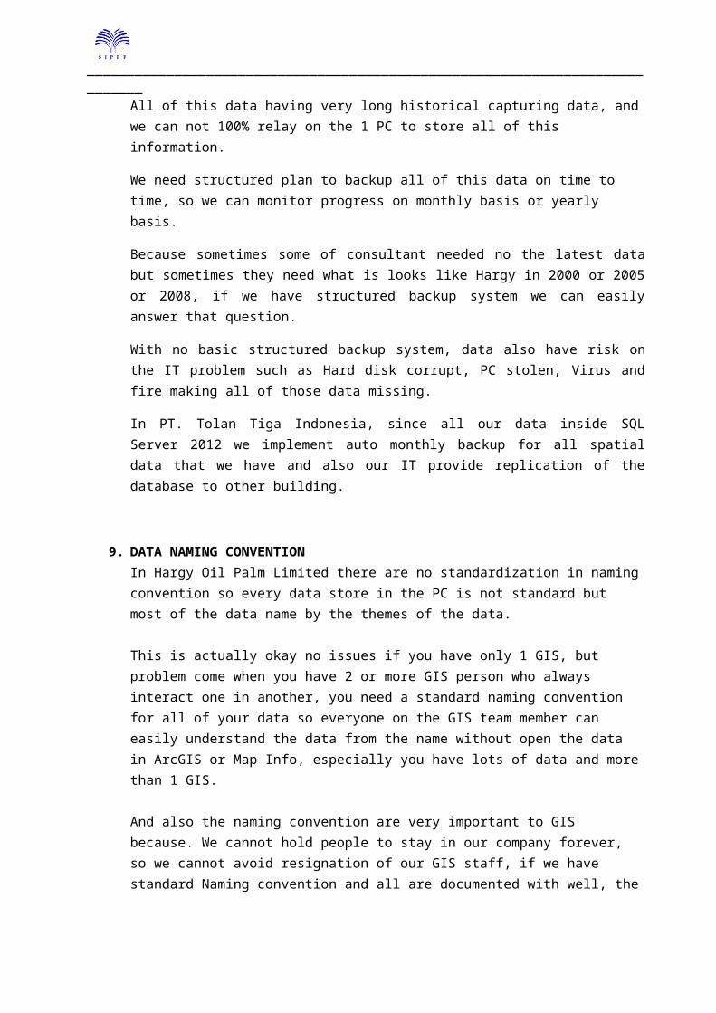
ArcGIS ServerArcGIS server is used to stream the multi user geodatabase so every single GIS Staff can use the data, edit the data and the publish it to the web so everybody not GIS can see the data to help them make a crucial decisions.
_____________________________________________________________________________
Hargy Oil Palm Limited not yet use the ArcGIS server for the daily operation and not yet have a system linked the LINTRAMAX and GIS data in the real-time.
Only with ArcGIS Server this link can possible established. Like in PT. Tolan Tiga Indonesia, Data from LINTRAMAX sync daily on 00.00 AM to GIS database (Using SQL Server 2012) and then from the GIS Server stream to web service using traffic light system so user easily understand the problem directly.
This is the major concept shown on below chart:
Picture 13
8. IT INFRASTRUCTURE AND BACKUP SYSTEM
Currently Hargy Oil Palm Limited doesn’t have IT Infrastructure for GIS, because all the data of GIS are kept in Local PC of GIS Staff.
Actually this is quite risk for the data because GIS data are very-very important and if it’s lost takes months or even years to reconstruct it.
For example:1. Land Compensation data (customary land LLB land etc.)2. Small holder GPS Mapping Data3. Plantation GPS Mapping data4. Etc.
All of this data having very long historical capturing data, and we can not 100% relay on the 1 PC to store all of this information.
We need structured plan to backup all of this data on time to time, so we can monitor progress on monthly basis or yearly basis.
Because sometimes some of consultant needed no the latest data but sometimes they need what is looks like Hargy in 2000 or 2005 or 2008, if we have structured backup system we can easily answer that question.
_____________________________________________________________________________
With no basic structured backup system, data also have risk on the IT problem such as Hard disk corrupt, PC stolen, Virus and fire making all of those data missing.
In PT. Tolan Tiga Indonesia, since all our data inside SQL Server 2012 we implement auto monthly backup for all spatial data that we have and also our IT provide replication of the database to other building.
9. DATA NAMING CONVENTIONIn Hargy Oil Palm Limited there are no standardization in naming convention so every data store in the PC is not standard but most of the data name by the themes of the data.
This is actually okay no issues if you have only 1 GIS, but problem come when you have 2 or more GIS person who always interact one in another, you need a standard naming convention for all of your data so everyone on the GIS team member can easily understand the data from the name without open the data in ArcGIS or Map Info, especially you have lots of data and more than 1 GIS.
And also the naming convention are very important to GIS because. We cannot hold people to stay in our company forever, so we cannot avoid resignation of our GIS staff, if we have standard Naming convention and all are documented with well, the handover jobs between new person and the resigned person would be very-very easy.
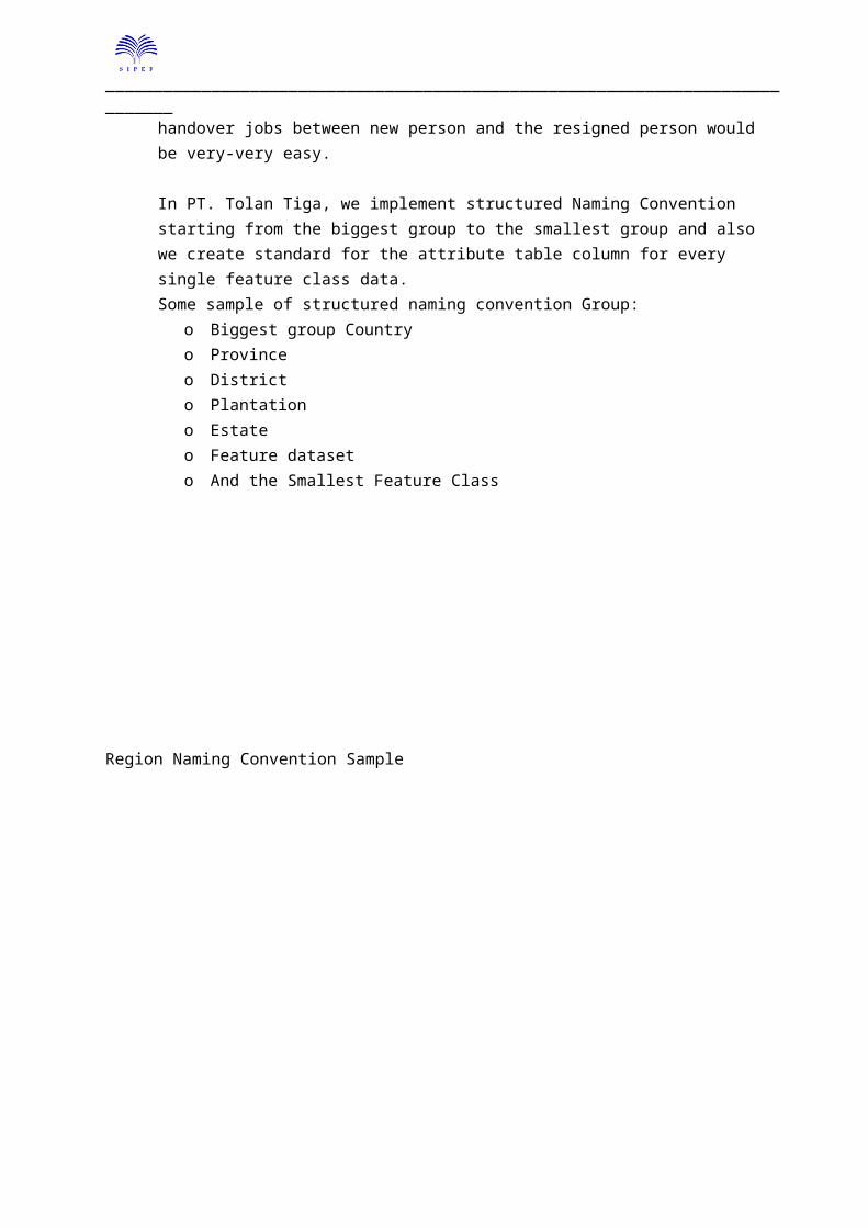
In PT. Tolan Tiga, we implement structured Naming Convention starting from the biggest group to the smallest group and also we create standard for the attribute table column for every single feature class data.Some sample of structured naming convention Group:
o Biggest group Countryo Provinceo Districto Plantationo Estateo Feature dataseto And the Smallest Feature Class
_____________________________________________________________________________
Region Naming Convention Sample
Picture 14
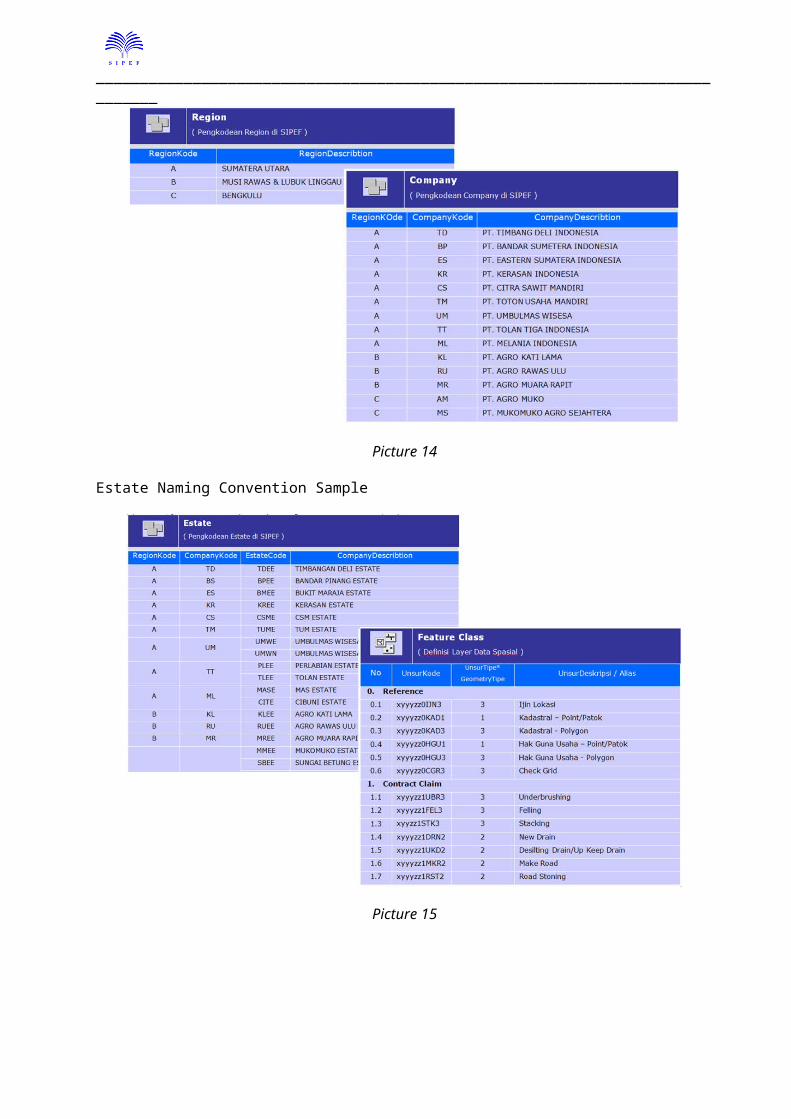
Estate Naming Convention Sample
Picture 15
_____________________________________________________________________________
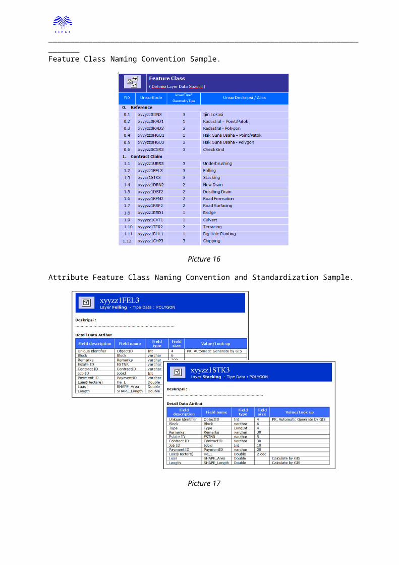
Feature Class Naming Convention Sample.
Picture 16
Attribute Feature Class Naming Convention and Standardization Sample.
Picture 17
_____________________________________________________________________________
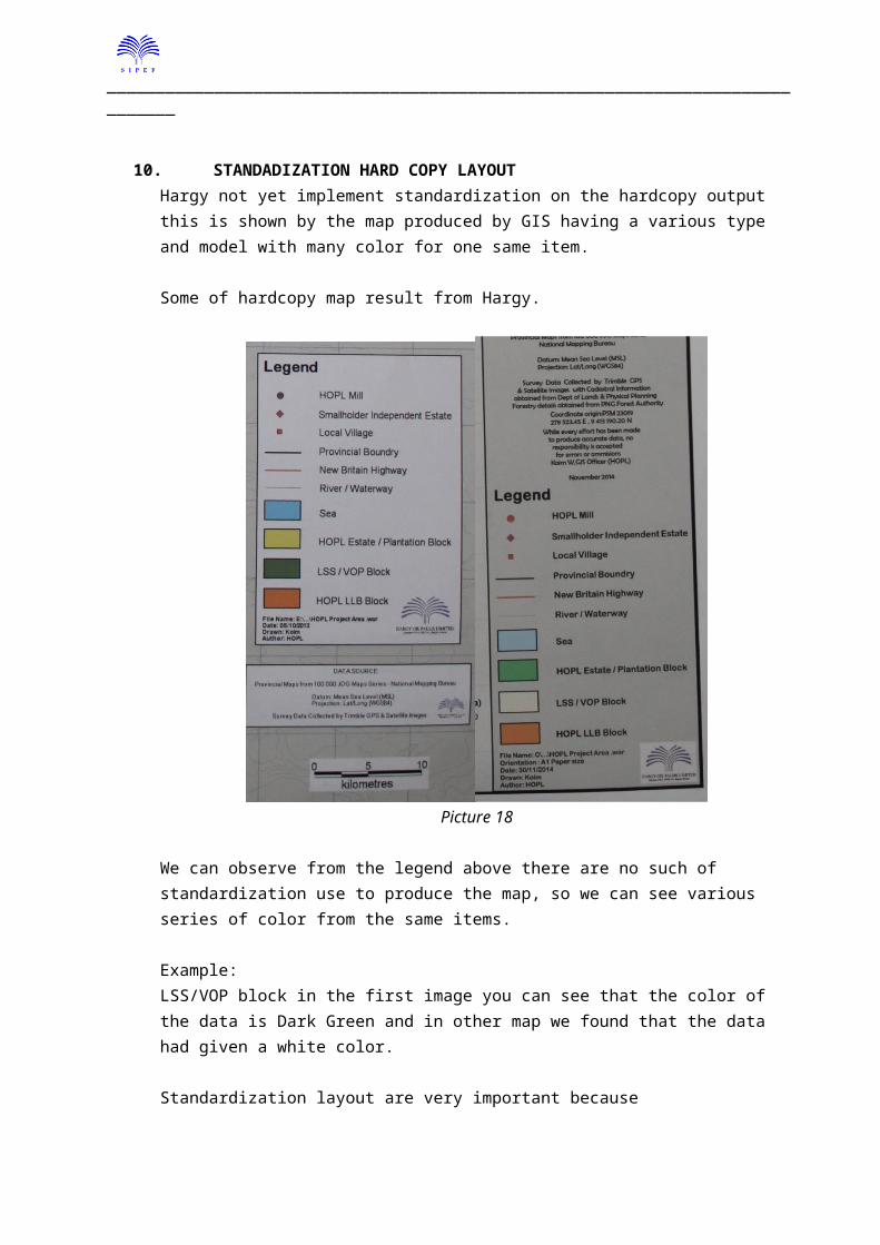
10. STANDADIZATION HARD COPY LAYOUTHargy not yet implement standardization on the hardcopy output this is shown by the map produced by GIS having a various type and model with many color for one same item.
Some of hardcopy map result from Hargy.
Picture 18
We can observe from the legend above there are no such of standardization use to produce the map, so we can see various series of color from the same items.
Example: LSS/VOP block in the first image you can see that the color of the data is Dark Green and in other map we found that the data had given a white color.
Standardization layout are very important because1. The standard layout can indicate from who the maps are come from.2. User would not be confused reading our maps, if the color symbol or other on the legend is
different every time we create map then user must carefully read our legend every map.So this is become very difficult for the user.
3. We need to follow the cartographic items standardization to fit the some consultant need.o Coordinateo Inseto Source of Data
_____________________________________________________________________________
o Date Produced o Create By/Authoro Legend
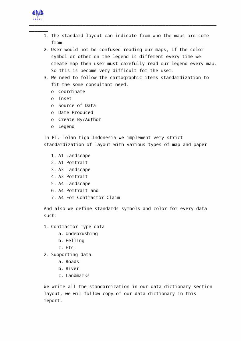
In PT. Tolan tiga Indonesia we implement very strict standardization of layout with various types of map and paper
1. A1 Landscape2. A1 Portrait3. A3 Landscape4. A3 Portrait5. A4 Landscape 6. A4 Portrait and7. A4 For Contractor Claim
And also we define standards symbols and color for every data such:
1. Contractor Type dataa. Undebrushingb. Fellingc. Etc.
2. Supporting dataa. Roadsb. Riverc. Landmarks
We write all the standardization in our data dictionary section layout, we wil follow copy of our data dictionary in this report.
Standard Layout in ArcGIS Desktop:
Picture 19
_____________________________________________________________________________
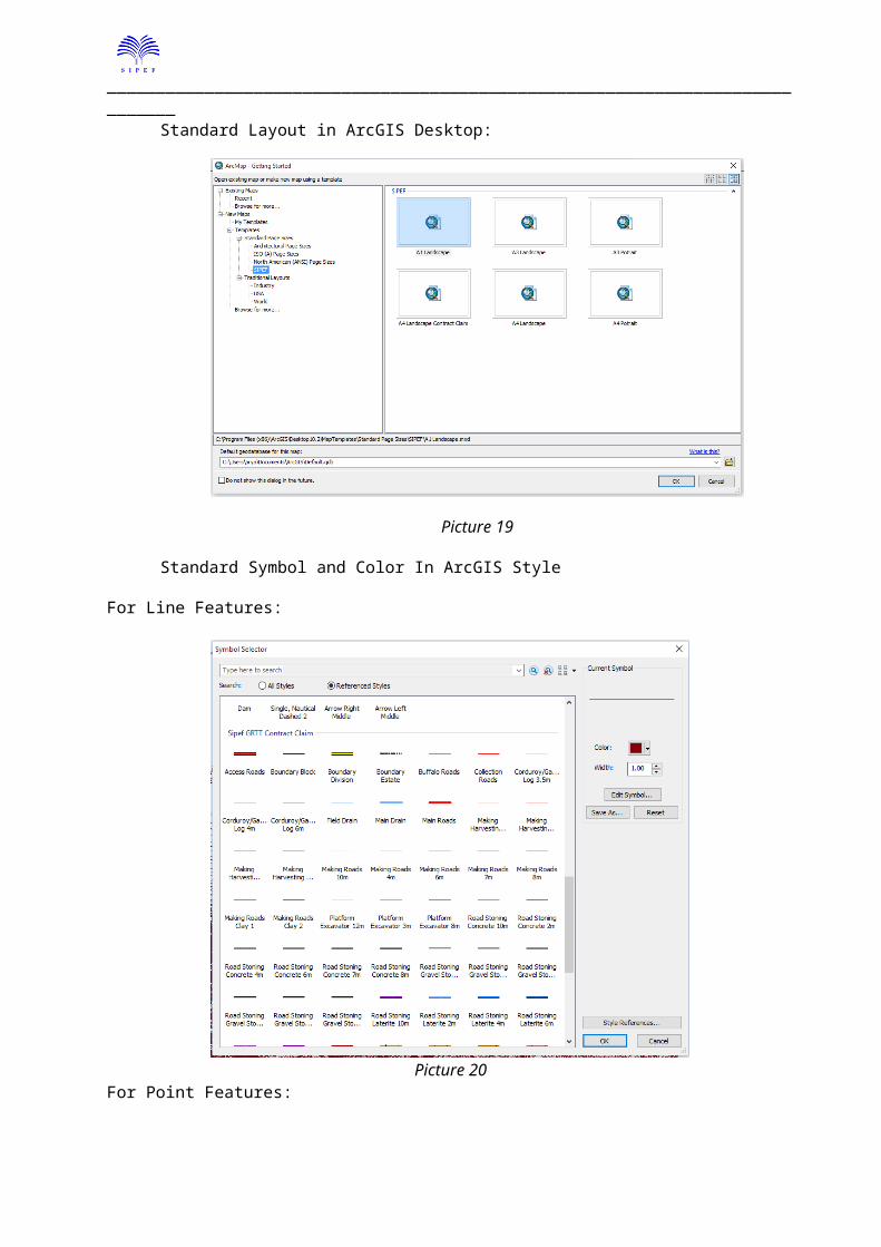
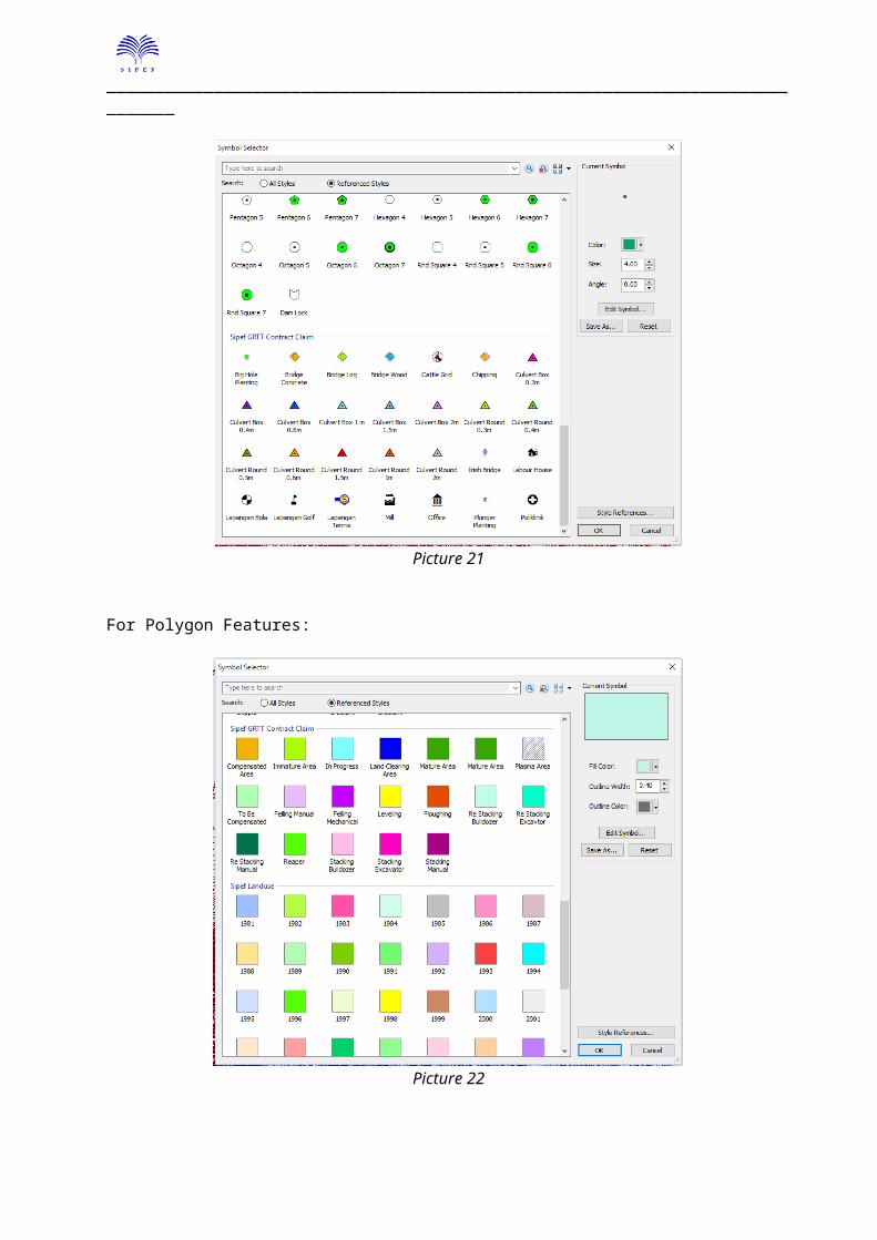
Standard Symbol and Color In ArcGIS Style
For Line Features:
Picture 20For Point Features:
Picture 21
_____________________________________________________________________________
For Polygon Features:
Picture 22
11. INVOLVEMENT IN PRE DEVELOPMENT/REPLANTING PROJECT AREA
Currently Hargy having very small Involvement in the pre development project there is a very small support of GIS to provide some the Land Clearing team valuable information about the location of the project.
Normally before a land is cultivated, we should know the rough picture of the location so the ground /Land Clearing team can doing some estimation about.
1. Whether terrace needed or not.2. How long the road will be3. How long the drain needed4. What is the block look likes. 5. What is the look like of the topography and how many percent area that categories as
steep area, flat area and adulating area.6. Where is the location of gullies, river or conservation area etc.
In PT. Tolan Tiga this information are must we doing a replanting project or planning to open the new area.
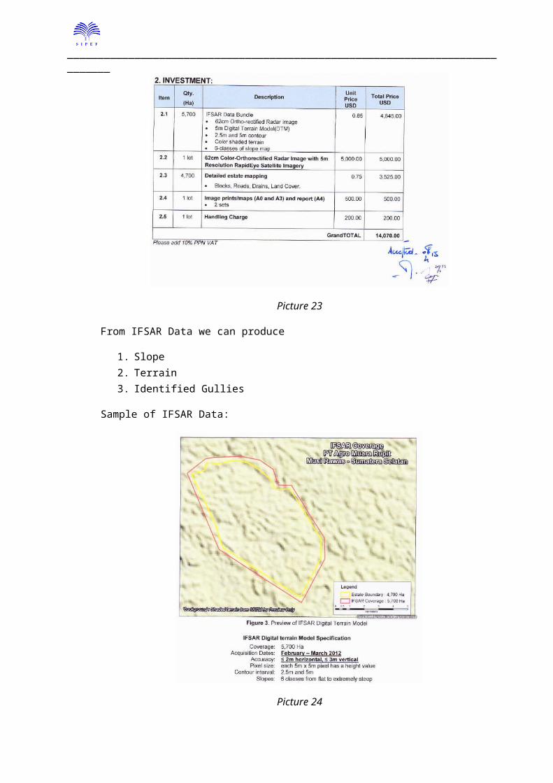
Tolan Tiga Invest quite a lot of money to buy the topographic data and medium resolution imagery of project area with resolution about 5m to support the Land Clearing team so they can doing some rough plan to manage the development land.
_____________________________________________________________________________
This is the screen shot of our quotation purchasing the data:
Picture 23
From IFSAR Data we can produce
1. Slope2. Terrain3. Identified Gullies
Sample of IFSAR Data:
Picture 24
_____________________________________________________________________________
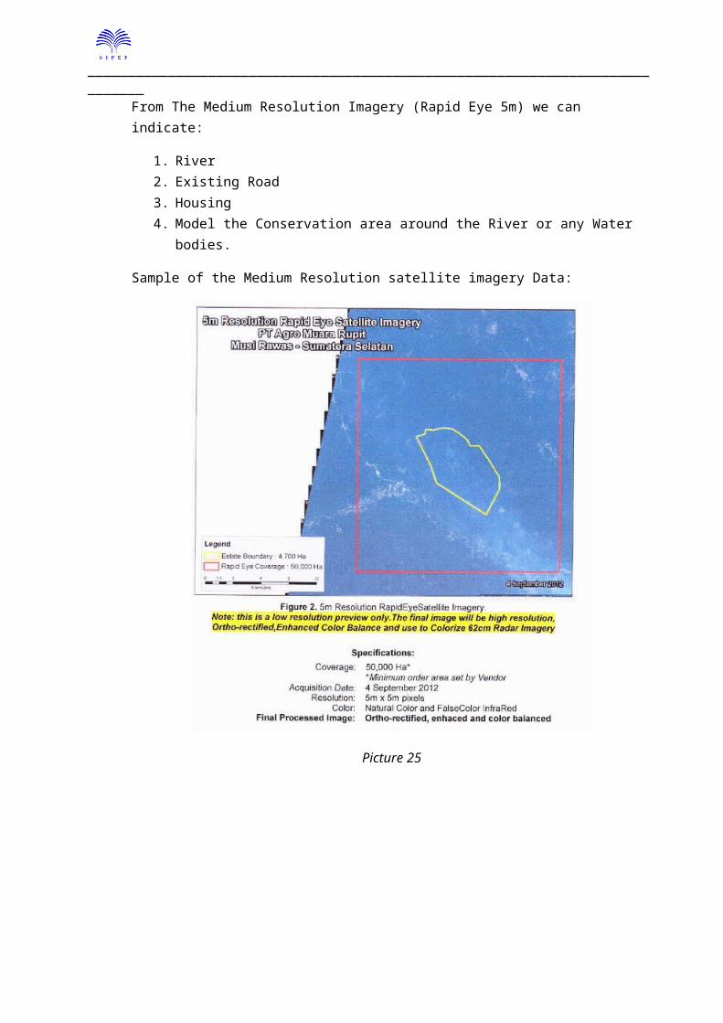
From The Medium Resolution Imagery (Rapid Eye 5m) we can indicate:
1. River2. Existing Road3. Housing4. Model the Conservation area around the River or any Water bodies.
Sample of the Medium Resolution satellite imagery Data:
Picture 25
_____________________________________________________________________________
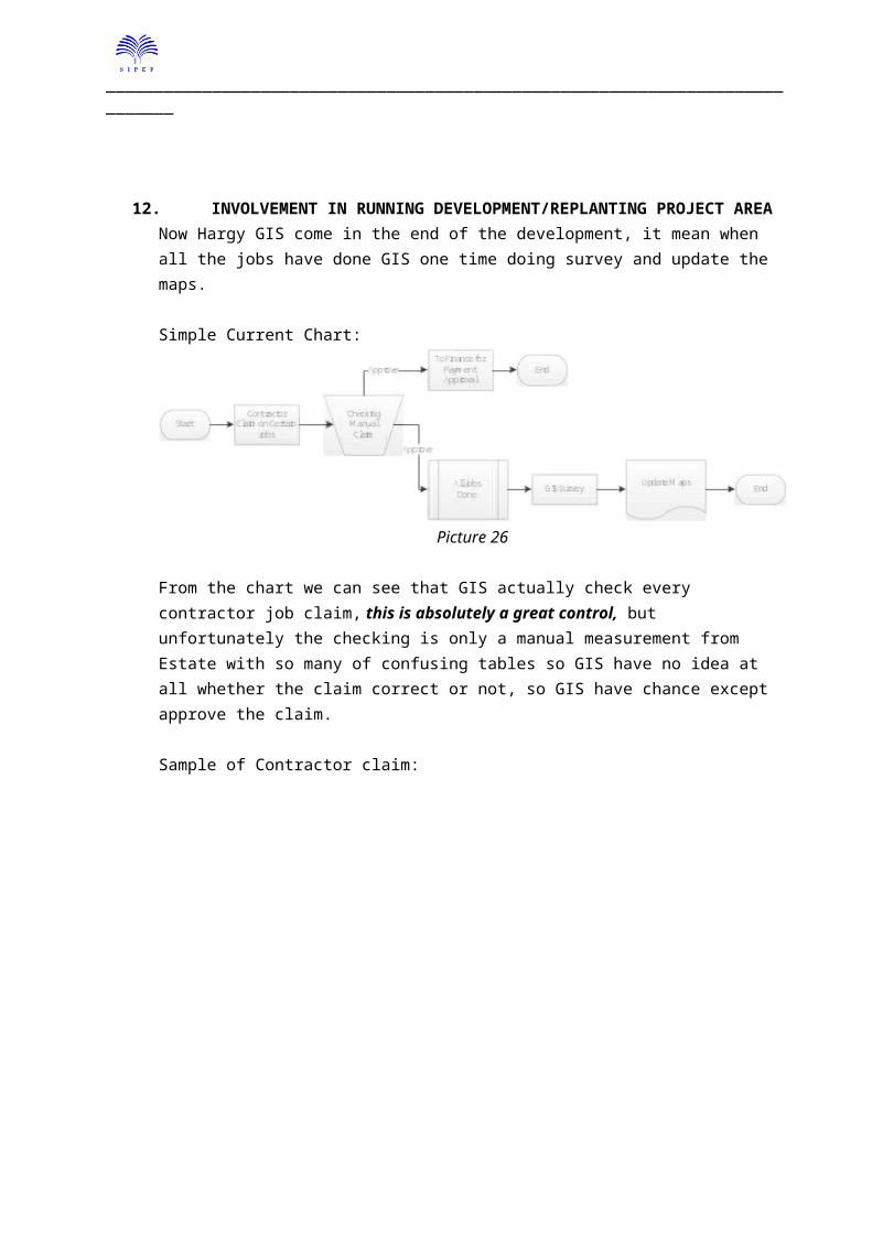
12. INVOLVEMENT IN RUNNING DEVELOPMENT/REPLANTING PROJECT AREANow Hargy GIS come in the end of the development, it mean when all the jobs have done GIS one time doing survey and update the maps.
Simple Current Chart:
Picture 26
From the chart we can see that GIS actually check every contractor job claim, this is absolutely a great control, but unfortunately the checking is only a manual measurement from Estate with so many of confusing tables so GIS have no idea at all whether the claim correct or not, so GIS have chance except approve the claim.
Sample of Contractor claim:
Picture 27
Looking from the document no way GIS can check whether this is corrects or not.
GIS should be able to become a last defense of the company to reduce the losing to unnecessary cost in development project, so GIS must able to detect:
_____________________________________________________________________________
1. Which one part of jobs has been paid?2. Real measurement of the work done.3. Where is the location of the jobs?
With this information we can control our development area better and we can trace the progress month by month with very easily.
In PT. Tolan Tiga the entire contractor claim should have GIS measurement data and only GIS authorize to produce the maps.
Simple Current Chart:
Picture 28
we can see that the measurement of Contractor Claim jobs are from the GIS of course in this survey there is a man from the contractor following as a witness so the contractor also sure that GIS measurement on the correct location and accurate.
_____________________________________________________________________________
Sample of the contractor Claim Maps.
Picture 29
Benefit to track all of the contract data for GIS are:1. GIS can able to track the land clearing progress and can deliver the monthly report to the
management.2. Add in benefit for the company is the companies have more control in the land clearing
activity of the development area.
_____________________________________________________________________________
13. MASTER DATA UPDATESince Hargy not monitor the Land Clearing in development project by GPS the update of the GIS master data are doing in the end of the development project or in very long time.
Picture 30
The maps actually update every 6 month.
In Tolan Tiga Indonesia, since we monitor the Contractor Claim we able to track every single movement of Hectare and statement changes.
14. DATA LINKAGE WITH ERP LINTRAMAX SYSTEM AND CURRENT FIELD SITUATIONBecause there is no regular checking to verify the linkage of Block data between LINTRAMAX and the GIS data we have found some broken linkage in the Block data.
Type of the error link is the Block data exist in GIS but we cannot found the block in LINTRAMAX yield production report.
Problem occurs in some of the estate:1. Navo Estate
a. Karla i. 12J31
ii. 12I25iii. 12I24iv. 12I22v. 12H21
_____________________________________________________________________________
vi. 98G11b. Ebana
i. 06Q082. Barema
a. 09B14b. 07D07c. 07C01
3. Hargya. 13P03b. 12P01c. 01L04d. 12P02
In the small holder data, block not yet similar with the current situation in the field, this problem cause not link between the production data and the block.
Map show the block information of Production of Small Holder data:
Picture 31
_____________________________________________________________________________
From the picture above indicated some meaning
1. Blank block = Mean not yet been fill by the block data.
Picture 32
2. Blank color with the block name inside = Mean block data not match with the existing production data.
Picture 33
3. Colored block = block already linked between the production data and the GIS data.
In PT. Tolan Tiga Indonesia because we have online map system we do regular checking for the block with doing thematic maps to the existing data, the thematic maps that usually we do.
_____________________________________________________________________________
1. Yield Per Ha2. Yield to date3. SPH4. Planting Year
For the block that lost link we use PDF map to verify the data on the ground, after that GIS will update the GIS master data with the current survey data.
Thanks
Arya WardhanaM-GIS TTI