


Languages
Pages
Legal


REV. 08/16/2012
------- FIELD LEVEL/NAME ---------- --PICTURE-- FLD START END LENGTH
LIST-DATA-20-21-22 1 700 700
3 RECORD-KEY GROUP 1 1 35 35
5 COUNTY-DISTRICT 9(4) 2 1 4 4
5 PROPERTY-ID GROUP 3 5 33 29
7 BLOCK X(9) 4 5 13 9
7 LOT X(9) 5 14 22 9
7 QUALIFIER X(11) 6 23 33 11
5 RECORD-ID 99 7 34 35 2
3 LIST-DATA GROUP 8 36 700 665
5 FILLER XX 9 36 37 2
5 TRANSACTION-DATE-MMDDYY 9(6) 10 38 43 6
5 TRANSACTION-UPDATE-NO 9(4) 11 44 47 4
5 TAX-ACCOUNT-NUMBER X(8) 12 48 55 8
5 PROPERTY-CLASS XXX 13 56 58 3
5 PROPERTY-LOCATION X(25) 14 59 83 25
5 BUILDING-DESCRIPTION X(15) 15 84 98 15
5 LAND-DESCRIPTION X(20) 16 99 118 20
5 CALCULATED-ACREAGE 9(5)V9(4) 17 119 127 9
5 ADDITION-LOTS1 X(20) 18 128 147 20
5 ADDITION-LOTS2 X(20) 19 148 167 20
5 ZONING X(4) 20 168 171 4
5 TAX-MAP-PAGE-NUMBER X(4) 21 172 175 4
5 OWNER-NAME X(35) 22 176 210 35
5 STREET-ADDRESS X(25) 23 211 235 25
5 CITY-STATE X(25) 24 236 260 25
5 ZIP-CODE X(9) 25 261 269 9
5 NUMBER-OF-OWNERS 9(4) 26 270 273 4
5 DEDUCTION-AMOUNT 9(6) 27 274 279 6
5 FILLER X 28 280 280 1
5 BANK-CODE X(5) 29 281 285 5
5 MORTGAGE-ACCOUNT-NUMBER X(10) 30 286 295 10
5 DEED-BOOK X(5) 31 296 300 5
5 DEED-PAGE X(5) 32 301 305 5
5 SALES-PRICE-CODE X 33 306 306 1
5 CURRENT-SALES-DATA GROUP 34 307 332 26
7 DEED-DATE-MMDDYY 9(6) 35 307 312 6
7 SALE-PRICE 9(9) 36 313 321 9
7 SALE-ASSESSMENT 9(9) 37 322 330 9
7 SALE-SR1A-UN-CODE XX 38 331 332 2
5 REBATE-DATA GROUP 39 333 359 27
7 SOCIAL-SECURITY-NO X(9) 40 333 341 9
7 SCHOOL-TAX-OVERAGE S9(7)V99 41 342 350 9
7 NO-OF-DWELLINGS XX 42 351 352 2
7 NO-OF-COMMERCIAL-DW XX 43 353 354 2
7 MULTIPLE-OCCUPANCY X 44 355 355 1
7 PERCENT-OWNED-CODE X 45 356 356 1
7 REBATE-CODE XX 46 357 358 2
7 DELINQUENT-CODE X 47 359 359 1

REV. 08/16/2012
------- FIELD LEVEL/NAME ---------- --PICTURE-- FLD START END LENGTH
5 EXEMPT-DATA GROUP 48 360 410 51
7 EXEMPT-PROPERTY-LIST-CODE GROUP 49 360 366 7
9 EPL-OWN XX 50 360 361 2
9 EPL-USE XX 51 362 363 2
9 EPL-DESC XXX 52 364 366 3
7 INITIAL-DATE-MMDDYY 9(6) 53 367 372 6
7 FURTHER-DATE-MMDDYY 9(6) 54 373 378 6
7 STATUTE-NUMBER X(12) 55 379 390 12
7 FACILITY-NAME X(20) 56 391 410 20
5 BUILDING-CLASS-CODE X(5) 57 411 415 5
5 YEAR-CONSTRUCTED X(4) 58 416 419 4
5 ASSESSMENT-CODE X 59 420 420 1
5 LAND-VALUE 9(9) 60 421 429 9
5 IMPROVEMENT-VALUE 9(9) 61 430 438 9
5 NET-VALUE 9(9) 62 439 447 9
5 SPECIAL-TAX-CODES GROUP 63 448 459 12
7 SPECIAL-TAX-CODE(1) OCCURS 4 TIMES
XXX 64 448 450 3
7 SPECIAL-TAX-CODE(2) XXX 64 451 453 3
7 SPECIAL-TAX-CODE(3) XXX 64 454 456 3
7 SPECIAL-TAX-CODE(4) XXX 64 457 459 3
5 EXEMPTIONS GROUP 65 460 495 36
7 EXEMPTION-ENTRY(1) OCCURS 4 TIMES
GROUP 66 460 468 9
9 EXEMPTION-CODE(1) X 67 460 460 1
9 EXEMPTION-AMT(1) 9(8) 68 461 468 8
7 EXEMPTION-ENTRY(2) GROUP 66 469 477 9
9 EXEMPTION-CODE(2) X 67 469 469 1
9 EXEMPTION-AMT(2) 9(8) 68 470 477 8
7 EXEMPTION-ENTRY(3) GROUP 66 478 486 9
9 EXEMPTION-CODE(3) X 67 478 478 1
9 EXEMPTION-AMT(3) 9(8) 68 479 486 8
7 EXEMPTION-ENTRY(4) GROUP 66 487 495 9
9 EXEMPTION-CODE(4) X 67 487 487 1
9 EXEMPTION-AMT(4) 9(8) 68 488 495 8
5 DEDUCTIONS GROUP 69 496 513 18
7 SENIOR-CITIZENS-CNT 9(4) 70 496 499 4
7 VETERANS-CNT 9(4) 71 500 503 4
7 WIDOWS-CNT 9(4) 72 504 507 4
7 SURV-SPOUSE-CNT 999 73 508 510 3
7 DISABLED-CNT 999 74 511 513 3
5 USER-FIELD1 X(4) 75 514 517 4
5 USER-FIELD2 X(4) 76 518 521 4
5 OLD-PROPERTY-ID X(29) 77 522 550 29
5 CENSUS-TRACT X(5) 78 551 555 5
5 CENSUS-BLOCK X(4) 79 556 559 4
5 PROPERTY-USE-CODE XXX 80 560 562 3
5 PROPERTY-FLAGS X(10) 81 563 572 10
5 TENANT-REBATE GROUP 82 573 595 23
7 REBATE-RESPONSE-FLG X 83 573 573 1
7 REBATE-BASE-YEAR X(4) 84 574 577 4
7 REBATE-BASE-YR-TAX S9(7)V99 85 578 586 9
7 REBATE-BASE-YR-NET-VAL 9(9) 86 587 595 9
5 FILLER X(5) 87 596 600 5

REV. 08/16/2012
------- FIELD LEVEL/NAME ---------- --PICTURE-- FLD START END LENGTH
5 TAXES GROUP 88 601 682 82
7 LAST-YEAR-TAX S9(7)V99 89 601 609 9
7 CURRENT-YEAR-TAX S9(7)V99 90 610 618 9
7 NON-MUNICIPAL-HALF1 S9(7)V99 91 619 627 9
7 NON-MUNICIPAL-HALF2 S9(7)V99 92 628 636 9
7 MUNICIPAL-HALF1 S9(7)V99 93 637 645 9
7 MUNICIPAL-HALF2 S9(7)V99 94 646 654 9
7 NON-MUNICIPAL-HALF3 S9(7)V99 95 655 663 9
7 MUNICIPAL-HALF3 S9(7)V99 96 664 672 9
7 BILL-STATUS-FLAG X 97 673 673 1
7 ESTIMATED-QTR3-TAX S9(7)V99 98 674 682 9
5 PRIOR-YR-NET-VALUE 9(9) 99 683 691 9
5 STATEMENT-OF-STATE-AID-AMT 9(7)V99 100 692 700 9

REV. 08/16/2012
EXPLANATIONS OF DATA FIELDS FOR THE
NEW JERSEY PROPERTY TAX SYSTEM
MOD IV
KEY:
M = Mandatory Field
O = Optional Field
* = Rarely Used Field
# = Not Maintainable (unable to update)
1. COUNTY NUMBER: (M) A two (2) digit numeric code representing the county.
2. DISTRICT NUMBER: (M) A two (2) digit numeric code representing the district within the county.
3. BLOCK: (M) A numerical identification representing a tax map block number as it appears on the tax list. The block is
nine characters, up to a five character block number and a four character block suffix.
LOT: (M)
A numerical identification representing a tax map lot number as it appears on the tax list. The lot is nine
characters, up to a five character lot number and a four character lot suffix.
QUALIFICATION CODE: (M) The sub-field for Qualification Codes may be used to make the property identification unique among
others with the same block and lot designation. The qualification code sub-field has eleven spaces.
The only codes that may be used are listed below:
W - Ward - followed by a two-digit number from 01 to 99 indicating the ward in which the property
is located.
S - Sector - followed by a two-digit number from 01 to 99 indicating the sector in which the property
is located.
T - Cell Tower - followed by a two-digit number from 01 to 99 indicating the cell tower number
within the municipality.
B - Billboard - followed by a two-digit number from 01 - 99 indicating the billboard number within
the municipality.
QFARM - Designates qualified farmland.
LOT - Indicates the land, separately assessed from the building.
BLDG - Indicates the building, separately assessed from the land.
CXXXX - Indicates a condominium unit. (Substitute the unit number for the X's).
Note: A unit number may be numeric, alpha or alpha/numeric. Leading zeros in the unit number will
remain intact on the Master File.
If unit numbers are repeated in more than one building on the same lot, the number may be
constructed as follows: CAO67 C = the condominium indicator, A = the building indicator and
067 = the unit number. In order to insure proper sequencing always use C plus all four positions.
REV. 08/16/2012
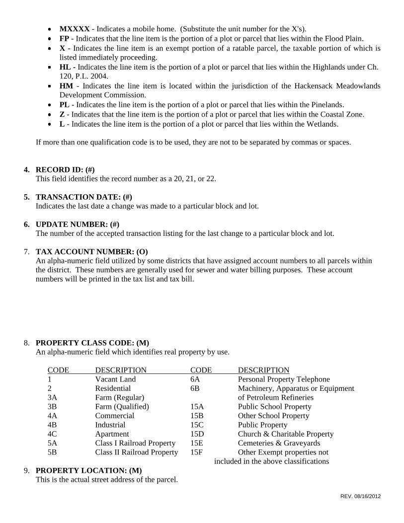
MXXXX - Indicates a mobile home. (Substitute the unit number for the X's).
FP - Indicates that the line item is the portion of a plot or parcel that lies within the Flood Plain.
X - Indicates the line item is an exempt portion of a ratable parcel, the taxable portion of which is
listed immediately proceeding.
HL - Indicates the line item is the portion of a plot or parcel that lies within the Highlands under Ch.
120, P.L. 2004.
HM - Indicates the line item is located within the jurisdiction of the Hackensack Meadowlands
Development Commission.
PL - Indicates the line item is the portion of a plot or parcel that lies within the Pinelands.
Z - Indicates that the line item is the portion of a plot or parcel that lies within the Coastal Zone.
L - Indicates the line item is the portion of a plot or parcel that lies within the Wetlands.
If more than one qualification code is to be used, they are not to be separated by commas or spaces.
4. RECORD ID: (#)
This field identifies the record number as a 20, 21, or 22.
5. TRANSACTION DATE: (#)
Indicates the last date a change was made to a particular block and lot.
6. UPDATE NUMBER: (#)
The number of the accepted transaction listing for the last change to a particular block and lot.
7. TAX ACCOUNT NUMBER: (O) An alpha-numeric field utilized by some districts that have assigned account numbers to all parcels within
the district. These numbers are generally used for sewer and water billing purposes. These account
numbers will be printed in the tax list and tax bill.
8. PROPERTY CLASS CODE: (M) An alpha-numeric field which identifies real property by use.
CODE DESCRIPTION CODE DESCRIPTION
1 Vacant Land 6A Personal Property Telephone
2 Residential 6B Machinery, Apparatus or Equipment
3A Farm (Regular) of Petroleum Refineries
3B Farm (Qualified) 15A Public School Property
4A Commercial 15B Other School Property
4B Industrial 15C Public Property
4C Apartment 15D Church & Charitable Property
5A Class I Railroad Property 15E Cemeteries & Graveyards
5B Class II Railroad Property 15F Other Exempt properties not
included in the above classifications
9. PROPERTY LOCATION: (M) This is the actual street address of the parcel.
REV. 08/16/2012
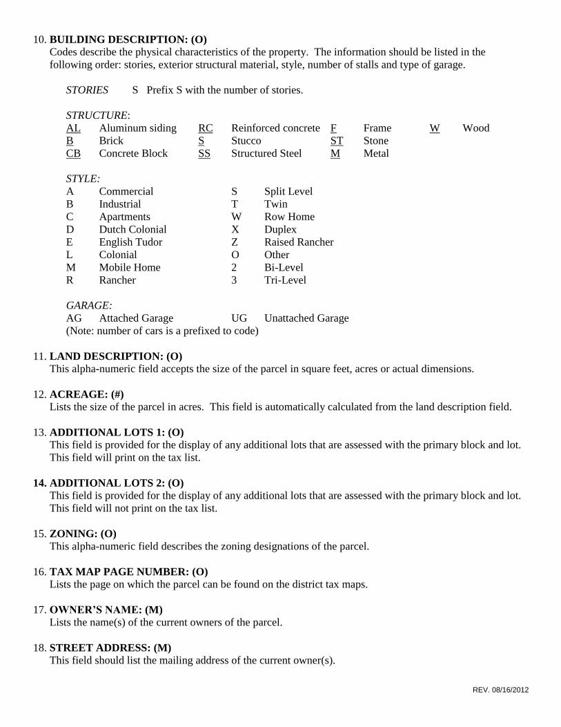
10. BUILDING DESCRIPTION: (O) Codes describe the physical characteristics of the property. The information should be listed in the
following order: stories, exterior structural material, style, number of stalls and type of garage.
STORIES S Prefix S with the number of stories.
STRUCTURE:
AL Aluminum siding RC Reinforced concrete F Frame W Wood
B Brick S Stucco ST Stone
CB Concrete Block SS Structured Steel M Metal
STYLE:
A Commercial S Split Level
B Industrial T Twin
C Apartments W Row Home
D Dutch Colonial X Duplex
E English Tudor Z Raised Rancher
L Colonial O Other
M Mobile Home 2 Bi-Level
R Rancher 3 Tri-Level
GARAGE:
AG Attached Garage UG Unattached Garage
(Note: number of cars is a prefixed to code)
11. LAND DESCRIPTION: (O) This alpha-numeric field accepts the size of the parcel in square feet, acres or actual dimensions.
12. ACREAGE: (#)
Lists the size of the parcel in acres. This field is automatically calculated from the land description field.
13. ADDITIONAL LOTS 1: (O)
This field is provided for the display of any additional lots that are assessed with the primary block and lot.
This field will print on the tax list.
14. ADDITIONAL LOTS 2: (O)
This field is provided for the display of any additional lots that are assessed with the primary block and lot.
This field will not print on the tax list.
15. ZONING: (O) This alpha-numeric field describes the zoning designations of the parcel.
16. TAX MAP PAGE NUMBER: (O)
Lists the page on which the parcel can be found on the district tax maps.
17. OWNER’S NAME: (M) Lists the name(s) of the current owners of the parcel.
18. STREET ADDRESS: (M)
This field should list the mailing address of the current owner(s).

REV. 08/16/2012
19. CITY & STATE: (M) This field should list the city and state of the current owner(s).
20. ZIP CODE: (M) This field should list the Zip Code of the current owner(s).
21. NUMBER OF OWNERS: (O)
This field represents the number of owners of a property where a property tax deduction exists.
22. DEDUCTION AMOUNT: (O) Lists the total dollar amount of deductions on the parcel.
23. BANK CODE: (O) A numeric code indicating the name of the lending institution holding a mortgage on the parcel.
24. MORTGAGE ACCOUNT: (O) A numeric code indicating the mortgage account number associated with the parcel.
25. DEED BOOK NUMBER: (O) Indicates the book number where the current deed is filed.
26. DEED PAGE NUMBER: (O) Indicates the page number where the current deed is filed.
27. SALES PRICE CODE: (O)
This indicates how a sale was investigated for sales ratio purposes.
A=Actual, F=Field, Q=Questionaire
28. DEED DATE: (O)
This is the date of deed for the sale of a property.
29. SALES PRICE: (O) This field shows the sales price indicated on the deed. The number one (1) indicates a nominal consideration
sale.
30. SALE ASSESSMENT: (O)
This field is for the assessment of the property at the time of the sale.
31. SOCIAL SECURITY NUMBER: (O)
This field is no longer used.
32. CO-CLAIMANT SOCIAL SECURITY NUMBER: (O)
This field is no longer used.
33. NUMBER OF DWELLINGS: (O, *)
This field indicates the number of residential dwelling units within the property.
34. NUMBER OF COMMERCIAL UNITS: (O, *)
This field indicates the number of commercial units within the property.
35. MULTIPLE OCCUPANCY CODE: (#)

REV. 08/16/2012
This field is not maintained.
36. PERCENT OWNED: (*)
1=10%, 2=20%, 3=30%, blank=100%.
37. REBATE CODE: (#) Field not maintained.
38. DELINQUENCY CODE: (#)
Field not maintained.
39. EXEMPT PROPERTY LIST CODE: (M) A numeric code identifying owner, purpose and specific use. This field is only mandatory for exempt
property.
40. INITIAL FILING DATE (MMDDYY): (O) The date of the initial filing of the application for exemption from local property taxation is filed with the
district assessor.
41. FURTHER FILING DATE (MMDDYY): (O) The date in which the application for continuance of exemption from local property taxation is completed
and returned to the district assessor.
42. EXEMPT STATUTE NUMBER: (O) The statute number under which the subject property claims exemption from local property taxes.
43. EXEMPT FACILITY NAME: (O) Description of facility type.
44. BUILDING CLASS CODE: (O)
The building class from the appraisal manual for New Jersey assessors describing the quality of a property.
45. CONSTRUCTION YEAR: (O)
This field indicates the year the building was constructed.
46. ASSESSMENT CODE: (O) A letter “P” would be entered in this field to indicate that the improvement was not complete prior to
October 1st of the pre-tax year. The assessment entered represents only a partial value of the total value of
the improvement when completed.
47. LAND VALUE: (M) The assessed value of the site.
48. IMPROVEMENT VALUE: (M) The assessed value of the all improvements to the site.
49. NET TAXABLE VALUE: (M) The value of the land plus the improvement value minus limited exemptions.
50. SPECIAL TAX CODES: (O) A single line item may have up to four (4) special taxing district codes.

REV. 08/16/2012
SPECIAL TAX CODE #1 F-Fire
SPECIAL TAX CODE #2 G-Garbage
SPECIAL TAX CODE #3 L-Light
SPECIAL TAX CODE #4 S-Special Improvement District
W-Water
51. LIMITED EXEMPTION/ABATEMENTS CODES & AMOUNTS: (O)
A single line item may contain up to four (4) limited exemptions/abatements.
EXEMPTION CODE #1
EXEMPTION AMOUNT #1
EXEMPTION CODE #2
EXEMPTION AMOUNT #2
EXEMPTION CODE #3
EXEMPTION AMOUNT #3
EXEMPTION CODE #4
EXEMPTION AMOUNT #4
ANY COMBINATION OF THESE CODES MAY APPEAR IN THE ABOVE FIELDS:
CODE DESCRIPTION
E Fire Suppression
F Fallout Shelter
P Pollution Control
W Water Supple Control
B Commercial/Industrial
H Household Improvement
M Multifamily Dwelling Improvement
I Dwell Exemption
J Dwell Abatement
K New Dwell Conv. Exemption
L New Dwell Conv. Abatement
G Commercial/Industrial Exemption
N Mult. Dwell Exemption
O Mult. Dwell Abatement
U UEZ Abatement (Urban Enterprise Zone)
52. DEDUCTIONS: (O)
CODE AMOUNT
SENIOR CITIZENS S $250
VETERANS V $250
WIDOWS W $250
SURVIVING SPOUSE R $250
DISABLED PERSONS D $250
53. USER FIELD 1: (*)
REV. 08/16/2012
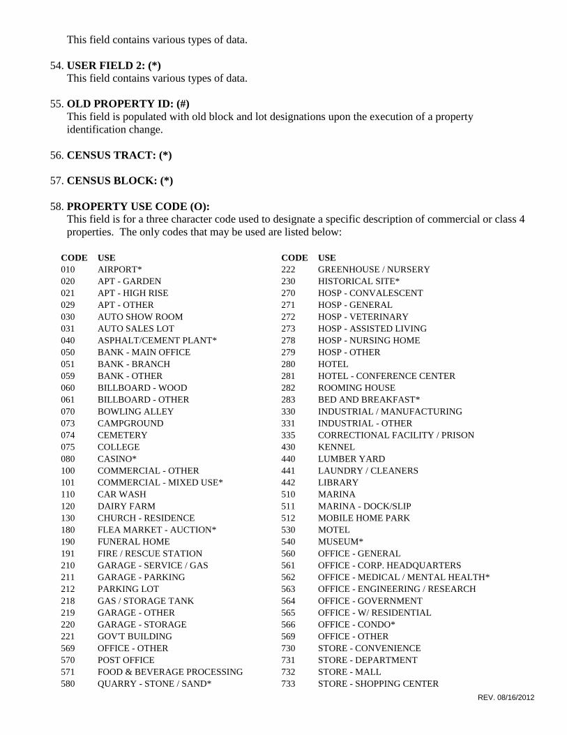
This field contains various types of data.
54. USER FIELD 2: (*)
This field contains various types of data.
55. OLD PROPERTY ID: (#)
This field is populated with old block and lot designations upon the execution of a property
identification change.
56. CENSUS TRACT: (*)
57. CENSUS BLOCK: (*)
58. PROPERTY USE CODE (O):
This field is for a three character code used to designate a specific description of commercial or class 4
properties. The only codes that may be used are listed below:
CODE USE CODE USE
010 AIRPORT* 222 GREENHOUSE / NURSERY
020 APT - GARDEN 230 HISTORICAL SITE*
021 APT - HIGH RISE 270 HOSP - CONVALESCENT
029 APT - OTHER 271 HOSP - GENERAL
030 AUTO SHOW ROOM 272 HOSP - VETERINARY
031 AUTO SALES LOT 273 HOSP - ASSISTED LIVING
040 ASPHALT/CEMENT PLANT* 278 HOSP - NURSING HOME
050 BANK - MAIN OFFICE 279 HOSP - OTHER
051 BANK - BRANCH 280 HOTEL
059 BANK - OTHER 281 HOTEL - CONFERENCE CENTER
060 BILLBOARD - WOOD 282 ROOMING HOUSE
061 BILLBOARD - OTHER 283 BED AND BREAKFAST*
070 BOWLING ALLEY 330 INDUSTRIAL / MANUFACTURING
073 CAMPGROUND 331 INDUSTRIAL - OTHER
074 CEMETERY 335 CORRECTIONAL FACILITY / PRISON
075 COLLEGE 430 KENNEL
080 CASINO* 440 LUMBER YARD
100 COMMERCIAL - OTHER 441 LAUNDRY / CLEANERS
101 COMMERCIAL - MIXED USE* 442 LIBRARY
110 CAR WASH 510 MARINA
120 DAIRY FARM 511 MARINA - DOCK/SLIP
130 CHURCH - RESIDENCE 512 MOBILE HOME PARK
180 FLEA MARKET - AUCTION* 530 MOTEL
190 FUNERAL HOME 540 MUSEUM*
191 FIRE / RESCUE STATION 560 OFFICE - GENERAL
210 GARAGE - SERVICE / GAS 561 OFFICE - CORP. HEADQUARTERS
211 GARAGE - PARKING 562 OFFICE - MEDICAL / MENTAL HEALTH*
212 PARKING LOT 563 OFFICE - ENGINEERING / RESEARCH
218 GAS / STORAGE TANK 564 OFFICE - GOVERNMENT
219 GARAGE - OTHER 565 OFFICE - W/ RESIDENTIAL
220 GARAGE - STORAGE 566 OFFICE - CONDO*
221 GOV'T BUILDING 569 OFFICE - OTHER
569 OFFICE - OTHER 730 STORE - CONVENIENCE
570 POST OFFICE 731 STORE - DEPARTMENT
571 FOOD & BEVERAGE PROCESSING 732 STORE - MALL
580 QUARRY - STONE / SAND* 733 STORE - SHOPPING CENTER
REV. 08/16/2012
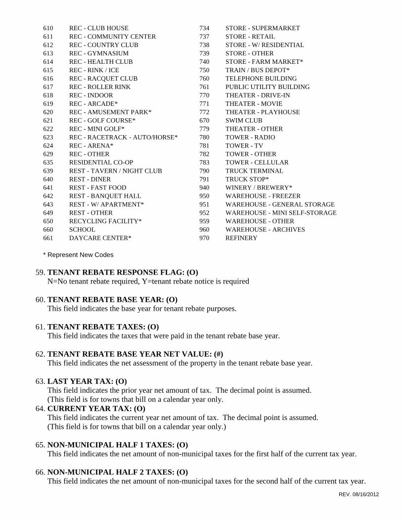
610 REC - CLUB HOUSE 734 STORE - SUPERMARKET
611 REC - COMMUNITY CENTER 737 STORE - RETAIL
612 REC - COUNTRY CLUB 738 STORE - W/ RESIDENTIAL
613 REC - GYMNASIUM 739 STORE - OTHER
614 REC - HEALTH CLUB 740 STORE - FARM MARKET*
615 REC - RINK / ICE 750 TRAIN / BUS DEPOT*
616 REC - RACQUET CLUB 760 TELEPHONE BUILDING
617 REC - ROLLER RINK 761 PUBLIC UTILITY BUILDING
618 REC - INDOOR 770 THEATER - DRIVE-IN
619 REC - ARCADE* 771 THEATER - MOVIE
620 REC - AMUSEMENT PARK* 772 THEATER - PLAYHOUSE
621 REC - GOLF COURSE* 670 SWIM CLUB
622 REC - MINI GOLF* 779 THEATER - OTHER
623 REC - RACETRACK - AUTO/HORSE* 780 TOWER - RADIO
624 REC - ARENA* 781 TOWER - TV
629 REC - OTHER 782 TOWER - OTHER
635 RESIDENTIAL CO-OP 783 TOWER - CELLULAR
639 REST - TAVERN / NIGHT CLUB 790 TRUCK TERMINAL
640 REST - DINER 791 TRUCK STOP*
641 REST - FAST FOOD 940 WINERY / BREWERY*
642 REST - BANQUET HALL 950 WAREHOUSE - FREEZER
643 REST - W/ APARTMENT* 951 WAREHOUSE - GENERAL STORAGE
649 REST - OTHER 952 WAREHOUSE - MINI SELF-STORAGE
650 RECYCLING FACILITY* 959 WAREHOUSE - OTHER
660 SCHOOL 960 WAREHOUSE - ARCHIVES
661 DAYCARE CENTER* 970 REFINERY
* Represent New Codes
59. TENANT REBATE RESPONSE FLAG: (O)
N=No tenant rebate required, Y=tenant rebate notice is required
60. TENANT REBATE BASE YEAR: (O)
This field indicates the base year for tenant rebate purposes.
61. TENANT REBATE TAXES: (O)
This field indicates the taxes that were paid in the tenant rebate base year.
62. TENANT REBATE BASE YEAR NET VALUE: (#)
This field indicates the net assessment of the property in the tenant rebate base year.
63. LAST YEAR TAX: (O)
This field indicates the prior year net amount of tax. The decimal point is assumed.
(This field is for towns that bill on a calendar year only.
64. CURRENT YEAR TAX: (O)
This field indicates the current year net amount of tax. The decimal point is assumed.
(This field is for towns that bill on a calendar year only.)
65. NON-MUNICIPAL HALF 1 TAXES: (O)
This field indicates the net amount of non-municipal taxes for the first half of the current tax year.
66. NON-MUNICIPAL HALF 2 TAXES: (O)
This field indicates the net amount of non-municipal taxes for the second half of the current tax year.

REV. 08/16/2012
67. MUNICIPAL HALF 1 TAXES: (O)
This field indicates the net amount of municipal taxes for the first half of the current tax year.
68. MUNICIPAL HALF 2 TAXES: (O)
This field indicates the net amount of municipal taxes for the second half of the current tax year.
69. NON-MUNICIPAL HALF 3 TAXES: (*)
This field is rarely used.
70. BILLLING STATUS FLAG: (*)
This field is rarely used.
71. ESTIMATED QUARTER 3 TAXES: (O)
This field indicates the third quarter bill is based on a percentage of last year’s taxes before the tax rates
have been determined.

REV. 08/16/2012
MUNICIPALITY COUNTY
0101 ABSECON CITY Atlantic County
0102 ATLANTIC CITY CITY Atlantic County
0103 BRIGANTINE CITY Atlantic County
0104 BUENA BORO Atlantic County
0105 BUENA VISTA TWP Atlantic County
0106 CORBIN CITY CITY Atlantic County
0107 EGG HARBOR CITY Atlantic County
0108 EGG HARBOR TWP Atlantic County
0109 ESTELL MANOR CITY Atlantic County
0110 FOLSOM BORO Atlantic County
0111 GALLOWAY TWP Atlantic County
0112 HAMILTON TWP Atlantic County
0113 HAMMONTON TOWN Atlantic County
0114 LINWOOD CITY Atlantic County
0115 LONGPORT BORO Atlantic County
0116 MARGATE CITY CITY Atlantic County
0117 MULLICA TWP Atlantic County
0118 NORTHFIELD CITY Atlantic County
0119 PLEASANTVILLE CITY Atlantic County
0120 PORT REPUBLIC CITY Atlantic County
0121 SOMERS POINT CITY Atlantic County
0122 VENTNOR CITY Atlantic County
0123 WEYMOUTH TWP Atlantic County
0201 ALLENDALE BORO Bergen County
0202 ALPINE BORO Bergen County
0203 BERGENFIELD BORO Bergen County
0204 BOGOTA BORO Bergen County
0205 CARLSTADT BORO Bergen County
0206 CLIFFSIDE PARK BORO Bergen County
0207 CLOSTER BORO Bergen County
0208 CRESSKILL BORO Bergen County
0209 DEMAREST BORO Bergen County
0210 DUMONT BORO Bergen County
0211 ELMWOOD PARK BORO Bergen County
0212 E RUTHERFORD BORO Bergen County
0213 EDGEWATER BORO Bergen County
0214 EMERSON BORO Bergen County
0215 ENGLEWOOD CITY Bergen County
0216 ENGLEWOOD CLIFFS BORO Bergen County
0217 FAIRLAWN BORO Bergen County
0218 FAIRVIEW BORO Bergen County
0219 FORT LEE BORO Bergen County
0220 FRANKLIN LAKES BORO Bergen County
0221 GARFIELD CITY Bergen County
0222 GLEN ROCK BORO Bergen County
0223 HACKENSACK CITY Bergen County
0224 HARRINGTON PARK BORO Bergen County
0225 HASBROUCK HGHTS BORO Bergen County
0226 HAWORTH BORO Bergen County
REV. 08/16/2012
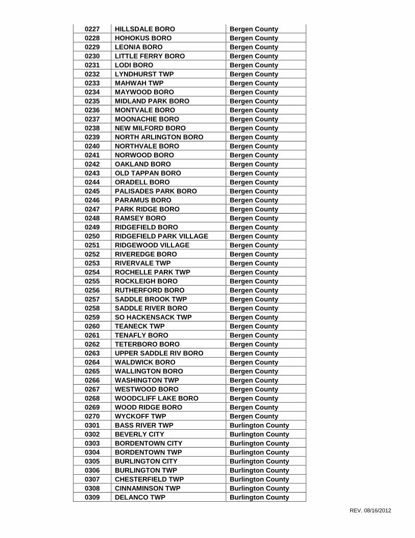
0227 HILLSDALE BORO Bergen County
0228 HOHOKUS BORO Bergen County
0229 LEONIA BORO Bergen County
0230 LITTLE FERRY BORO Bergen County
0231 LODI BORO Bergen County
0232 LYNDHURST TWP Bergen County
0233 MAHWAH TWP Bergen County
0234 MAYWOOD BORO Bergen County
0235 MIDLAND PARK BORO Bergen County
0236 MONTVALE BORO Bergen County
0237 MOONACHIE BORO Bergen County
0238 NEW MILFORD BORO Bergen County
0239 NORTH ARLINGTON BORO Bergen County
0240 NORTHVALE BORO Bergen County
0241 NORWOOD BORO Bergen County
0242 OAKLAND BORO Bergen County
0243 OLD TAPPAN BORO Bergen County
0244 ORADELL BORO Bergen County
0245 PALISADES PARK BORO Bergen County
0246 PARAMUS BORO Bergen County
0247 PARK RIDGE BORO Bergen County
0248 RAMSEY BORO Bergen County
0249 RIDGEFIELD BORO Bergen County
0250 RIDGEFIELD PARK VILLAGE Bergen County
0251 RIDGEWOOD VILLAGE Bergen County
0252 RIVEREDGE BORO Bergen County
0253 RIVERVALE TWP Bergen County
0254 ROCHELLE PARK TWP Bergen County
0255 ROCKLEIGH BORO Bergen County
0256 RUTHERFORD BORO Bergen County
0257 SADDLE BROOK TWP Bergen County
0258 SADDLE RIVER BORO Bergen County
0259 SO HACKENSACK TWP Bergen County
0260 TEANECK TWP Bergen County
0261 TENAFLY BORO Bergen County
0262 TETERBORO BORO Bergen County
0263 UPPER SADDLE RIV BORO Bergen County
0264 WALDWICK BORO Bergen County
0265 WALLINGTON BORO Bergen County
0266 WASHINGTON TWP Bergen County
0267 WESTWOOD BORO Bergen County
0268 WOODCLIFF LAKE BORO Bergen County
0269 WOOD RIDGE BORO Bergen County
0270 WYCKOFF TWP Bergen County
0301 BASS RIVER TWP Burlington County
0302 BEVERLY CITY Burlington County
0303 BORDENTOWN CITY Burlington County
0304 BORDENTOWN TWP Burlington County
0305 BURLINGTON CITY Burlington County
0306 BURLINGTON TWP Burlington County
0307 CHESTERFIELD TWP Burlington County
0308 CINNAMINSON TWP Burlington County
0309 DELANCO TWP Burlington County

REV. 08/16/2012
0310 DELRAN TWP Burlington County
0311 EASTAMPTON TWP Burlington County
0312 EDGEWATER PARK TWP Burlington County
0313 EVESHAM TWP Burlington County
0314 FIELDSBORO BORO Burlington County
0315 FLORENCE TWP Burlington County
0316 HAINESPORT TWP Burlington County
0317 LUMBERTON TWP Burlington County
0318 MANSFIELD TWP Burlington County
0319 MAPLE SHADE TWP Burlington County
0320 MEDFORD TWP Burlington County
0321 MEDFORD LAKES BORO Burlington County
0322 MOORESTOWN TWP Burlington County
0323 MT HOLLY TWP Burlington County
0324 MT LAUREL TWP Burlington County
0325 NEW HANOVER TWP Burlington County
0326 NO HANOVER TWP Burlington County
0327 PALMYRA BORO Burlington County
0328 PEMBERTON BORO Burlington County
0329 PEMBERTON TWP Burlington County
0330 RIVERSIDE TWP Burlington County
0331 RIVERTON BORO Burlington County
0332 SHAMONG TWP Burlington County
0333 SOUTHAMPTON TWP Burlington County
0334 SPRINGFIELD TWP Burlington County
0335 TABERNACLE TWP Burlington County
0336 WASHINGTON TWP Burlington County
0337 WESTAMPTON TWP Burlington County
0338 WILLINGBORO TWP Burlington County
0339 WOODLAND TWP Burlington County
0340 WRIGHTSTOWN BORO Burlington County
0401 AUDUBON BORO Camden County
0402 AUDUBON PARK BORO Camden County
0403 BARRINGTON BORO Camden County
0404 BELLMAWR BORO Camden County
0405 BERLIN BORO Camden County
0406 BERLIN TWP Camden County
0407 BROOKLAWN BORO Camden County
0408 CAMDEN CITY Camden County
0409 CHERRY HILL TWNSHP Camden County
0410 CHESILHURST BORO Camden County
0411 CLEMENTON BORO Camden County
0412 COLLINGSWOOD BORO Camden County
0413 GIBBSBORO BORO Camden County
0414 GLOUCESTER CITY Camden County
0415 GLOUCESTER TWP Camden County
0416 HADDON TWP Camden County
0417 HADDONFIELD BORO Camden County
0418 HADDON HEIGHTS BORO Camden County
0419 HI NELLA BORO Camden County
0420 LAUREL SPRINGS BORO Camden County
0421 LAWNSIDE BORO Camden County
0422 LINDENWOLD BORO Camden County

REV. 08/16/2012
0423 MAGNOLIA BORO Camden County
0424 MERCHANTVILLE BORO Camden County
0425 MOUNT EPHRAIM BORO Camden County
0426 OAKLYN BORO Camden County
0427 PENNSAUKEN TWP Camden County
0428 PINE HILL BORO Camden County
0429 PINE VALLEY BORO Camden County
0430 RUNNEMEDE BORO Camden County
0431 SOMERDALE BORO Camden County
0432 STRATFORD BORO Camden County
0433 TAVISTOCK BORO Camden County
0434 VOORHEES TWP Camden County
0435 WATERFORD TWP Camden County
0436 WINSLOW TWP Camden County
0437 WOODLYNNE BORO Camden County
0501 AVALON BORO Cape May County
0502 CAPE MAY CITY Cape May County
0503 CAPE MAY POINT BORO Cape May County
0504 DENNIS TWP Cape May County
0505 LOWER TWP Cape May County
0506 MIDDLE TWP Cape May County
0507 NORTH WILDWOOD CITY Cape May County
0508 OCEAN CITY CITY Cape May County
0509 SEA ISLE CITY CITY Cape May County
0510 STONE HARBOR BORO Cape May County
0511 UPPER TWP Cape May County
0512 WEST CAPE MAY BORO Cape May County
0513 WEST WILDWOOD BORO Cape May County
0514 WILDWOOD CITY Cape May County
0515 WILDWOOD CREST BORO Cape May County
0516 WOODBINE BORO Cape May County
0601 BRIDGETON CITY Cumberland County
0602 COMMERCIAL TWP Cumberland County
0603 DEERFIELD TWP Cumberland County
0604 DOWNE TWP Cumberland County
0605 FAIRFIELD TWP Cumberland County
0606 GREENWICH TWP Cumberland County
0607 HOPEWELL TWP Cumberland County
0608 LAWRENCE TWP Cumberland County
0609 MAURICE RIVER TWP Cumberland County
0610 MILLVILLE CITY Cumberland County
0611 SHILOH BORO Cumberland County
0612 STOW CREEK TWP Cumberland County
0613 UPPER DEERFIELD TWP Cumberland County
0614 VINELAND CITY Cumberland County
0701 BELLEVILLE TWP Essex County
0702 BLOOMFIELD TWP Essex County
0703 CALDWELL BORO TWP Essex County
0704 CEDAR GROVE TWP Essex County
0705 EAST ORANGE CITY Essex County
0706 ESSEX FELLS TWP Essex County
0707 FAIRFIELD TWP Essex County
0708 GLEN RIDGE BORO Essex County

REV. 08/16/2012
0709 IRVINGTON TWP Essex County
0710 LIVINGSTON TWP Essex County
0711 MAPLEWOOD TWP Essex County
0712 MILLBURN TWP Essex County
0713 MONTCLAIR TWP Essex County
0714 NEWARK CITY Essex County
0715 NORTH CALDWELL TWP Essex County
0716 NUTLEY TWP Essex County
0717 ORANGE CITY TWP Essex County
0718 ROSELAND BORO Essex County
0719 SOUTH ORANGE VILLAGE TW Essex County
0720 VERONA TWP Essex County
0721 WEST CALDWELL TWP Essex County
0722 WEST ORANGE TWP Essex County
0801 CLAYTON BORO Gloucester County
0802 DEPTFORD TWP Gloucester County
0803 EAST GREENWICH TWP Gloucester County
0804 ELK TWP Gloucester County
0805 FRANKLIN TWP Gloucester County
0806 GLASSBORO BORO Gloucester County
0807 GREENWICH TWP Gloucester County
0808 HARRISON TWP Gloucester County
0809 LOGAN TWP Gloucester County
0810 MANTUA TWP Gloucester County
0811 MONROE TWP Gloucester County
0812 NATIONAL PARK BORO Gloucester County
0813 NEWFIELD BORO Gloucester County
0814 PAULSBORO BORO Gloucester County
0815 PITMAN BORO Gloucester County
0816 SO HARRISON TWP Gloucester County
0817 SWEDESBORO BORO Gloucester County
0818 WASHINGTON TWP Gloucester County
0819 WENONAH BORO Gloucester County
0820 WEST DEPTFORD TWP Gloucester County
0821 WESTVILLE BORO Gloucester County
0822 WOODBURY CITY Gloucester County
0823 WOODBURY HEIGHTS BORO Gloucester County
0824 WOOLWICH TWP Gloucester County
0901 BAYONNE CITY Hudson County
0902 EAST NEWARK BORO Hudson County
0903 GUTTENBERG TOWN Hudson County
0904 HARRISON TOWN Hudson County
0905 HOBOKEN CITY Hudson County
0906 JERSEY CITY CITY Hudson County
0907 KEARNY TOWN Hudson County
0908 NORTH BERGEN TWP Hudson County
0909 SECAUCUS TOWN Hudson County
0910 UNION CITY CITY Hudson County
0911 WEEHAWKEN TWP Hudson County
0912 WEST NEW YORK TOWN Hudson County
1001 ALEXANDRIA TWP Hunterdon County
1002 BETHLEHEM TWP Hunterdon County
1003 BLOOMSBURY BORO Hunterdon County

REV. 08/16/2012
1004 CALIFON BORO Hunterdon County
1005 CLINTON TOWN Hunterdon County
1006 CLINTON TWP Hunterdon County
1007 DELAWARE TWP Hunterdon County
1008 EAST AMWELL TWP Hunterdon County
1009 FLEMINGTON BORO Hunterdon County
1010 FRANKLIN TWP Hunterdon County
1011 FRENCHTOWN BORO Hunterdon County
1012 GLEN GARDNER BORO Hunterdon County
1013 HAMPTON BORO Hunterdon County
1014 HIGH BRIDGE BORO Hunterdon County
1015 HOLLAND TWP Hunterdon County
1016 KINGWOOD TWP Hunterdon County
1017 LAMBERTVILLE CITY Hunterdon County
1018 LEBANON BORO Hunterdon County
1019 LEBANON TWP Hunterdon County
1020 MILFORD BORO Hunterdon County
1021 RARITAN TWP Hunterdon County
1022 READINGTON TWP Hunterdon County
1023 STOCKTON BORO Hunterdon County
1024 TEWKSBURY TWP Hunterdon County
1025 UNION TWP Hunterdon County
1026 WEST AMWELL TWP Hunterdon County
1101 EAST WINDSOR TWP Mercer County
1102 EWING TWP Mercer County
1103 HAMILTON TWP Mercer County
1104 HIGHTSTOWN BORO Mercer County
1105 HOPEWELL BORO Mercer County
1106 HOPEWELL TWP Mercer County
1107 LAWRENCE TWP Mercer County
1108 PENNINGTON BORO Mercer County
1111 TRENTON CITY Mercer County
1112 ROBBINSVILLE TWP Mercer County
1113 WEST WINDSOR TWP Mercer County
1114 PRINCETON** Mercer County
**Princeton Boro (1109) and Princeton Twp (1110) merged into one municipality Princeton (1114) effective January 1, 2013.
1201 CARTERET BORO Middlesex County
1202 CRANBURY TWP Middlesex County
1203 DUNELLEN BORO Middlesex County
1204 EAST BRUNSWICK TWP Middlesex County
1205 EDISON TWP Middlesex County
1206 HELMETTA BORO Middlesex County
1207 HIGHLAND PARK BORO Middlesex County
1208 JAMESBURG BORO Middlesex County
1209 METUCHEN BORO Middlesex County
1210 MIDDLESEX BORO Middlesex County
1211 MILLTOWN BORO Middlesex County
1212 MONROE TWP Middlesex County
1213 NEW BRUNSWICK CITY Middlesex County
1214 NORTH BRUNSWICK TWP Middlesex County
1215 OLD BRIDGE TWP Middlesex County
1216 PERTH AMBOY CITY Middlesex County

REV. 08/16/2012
1217 PISCATAWAY TWP Middlesex County
1218 PLAINSBORO TWP Middlesex County
1219 SAYREVILLE BORO Middlesex County
1220 SOUTH AMBOY CITY Middlesex County
1221 SOUTH BRUNSWICK TWP Middlesex County
1222 SOUTH PLAINFIELD BORO Middlesex County
1223 SOUTH RIVER BORO Middlesex County
1224 SPOTSWOOD BORO Middlesex County
1225 WOODBRIDGE TWP Middlesex County
1301 ABERDEEN TWP Monmouth County
1302 ALLENHURST BORO Monmouth County
1303 ALLENTOWN BORO Monmouth County
1304 ASBURY PARK CITY Monmouth County
1305 ATLANTIC HIGHLANDS BORO Monmouth County
1306 AVON BY THE SEA BORO Monmouth County
1307 BELMAR BORO Monmouth County
1308 BRADLEY BEACH BORO Monmouth County
1309 BRIELLE BORO Monmouth County
1310 COLTS NECK TOWNSHIP Monmouth County
1311 DEAL BORO Monmouth County
1312 EATONTOWN BORO Monmouth County
1313 ENGLISHTOWN BORO Monmouth County
1314 FAIR HAVEN BORO Monmouth County
1315 FARMINGDALE BORO Monmouth County
1316 FREEHOLD BORO Monmouth County
1317 FREEHOLD TWP Monmouth County
1318 HAZLET TWP Monmouth County
1319 HIGHLANDS BORO Monmouth County
1320 HOLMDEL TWP Monmouth County
1321 HOWELL TWP Monmouth County
1322 INTERLAKEN BORO Monmouth County
1323 KEANSBURG BORO Monmouth County
1324 KEYPORT BORO Monmouth County
1325 LITTLE SILVER BORO Monmouth County
1326 LOCH ARBOUR VILLAGE Monmouth County
1327 LONG BRANCH CITY Monmouth County
1328 MANALAPAN TWP Monmouth County
1329 MANASQUAN BORO Monmouth County
1330 MARLBORO TWP Monmouth County
1331 MATAWAN BORO Monmouth County
1332 MIDDLETOWN TWP Monmouth County
1333 MILLSTONE TWP Monmouth County
1334 MONMOUTH BEACH BORO Monmouth County
1335 NEPTUNE TWP Monmouth County
1336 NEPTUNE CITY BORO Monmouth County
1337 OCEAN TWP Monmouth County
1338 OCEANPORT BORO Monmouth County
1339 RED BANK BORO Monmouth County
1340 ROOSEVELT BORO Monmouth County
1341 RUMSON BORO Monmouth County
1342 SEA BRIGHT BORO Monmouth County
1343 SEA GIRT BORO Monmouth County
1344 SHREWSBURY BORO Monmouth County

REV. 08/16/2012
1345 SHREWSBURY TWP Monmouth County
1346 LAKE COMO BORO Monmouth County
1347 SPRING LAKE BORO Monmouth County
1348 SPRING LAKE HEIGHTS BOR Monmouth County
1349 TINTON FALLS BORO Monmouth County
1350 UNION BEACH BORO Monmouth County
1351 UPPER FREEHOLD TWP Monmouth County
1352 WALL TWP Monmouth County
1353 WEST LONG BRANCH BORO Monmouth County
1401 BOONTON TOWN Morris County
1402 BOONTON TWP Morris County
1403 BUTLER BORO Morris County
1404 CHATHAM BORO Morris County
1405 CHATHAM TWP Morris County
1406 CHESTER BORO Morris County
1407 CHESTER TWP Morris County
1408 DENVILLE TWP Morris County
1409 DOVER TOWN Morris County
1410 EAST HANOVER TWP Morris County
1411 FLORHAM PARK BORO Morris County
1412 HANOVER TWP Morris County
1413 HARDING TWP Morris County
1414 JEFFERSON TWP Morris County
1415 KINNELON BORO Morris County
1416 LINCOLN PARK BORO Morris County
1417 MADISON BORO Morris County
1418 MENDHAM BORO Morris County
1419 MENDHAM TWP Morris County
1420 MINE HILL TWP Morris County
1421 MONTVILLE TWP Morris County
1422 MORRIS TWP Morris County
1423 MORRIS PLAINS BORO Morris County
1424 MORRISTOWN TOWN Morris County
1425 MOUNTAIN LAKES BORO Morris County
1426 MOUNT ARLINGTON BORO Morris County
1427 MOUNT OLIVE TWP Morris County
1428 NETCONG BORO Morris County
1429 PARSIPPANY TR HLS TWP Morris County
1430 LONG HILL TWP Morris County
1431 PEQUANNOCK TWP Morris County
1432 RANDOLPH TWP Morris County
1433 RIVERDALE BORO Morris County
1434 ROCKAWAY BORO Morris County
1435 ROCKAWAY TWP Morris County
1436 ROXBURY TWP Morris County
1437 VICTORY GARDENS BORO Morris County
1438 WASHINGTON TWP Morris County
1439 WHARTON BORO Morris County
1501 BARNEGAT TWP Ocean County
1502 BARNEGAT LIGHT BORO Ocean County
1503 BAY HEAD BORO Ocean County
1504 BEACH HAVEN BORO Ocean County
1505 BEACHWOOD BORO Ocean County

REV. 08/16/2012
1506 BERKELEY TWP Ocean County
1507 BRICK TWP Ocean County
1508 TOMS RIVER TWP Ocean County
1509 EAGLESWOOD TWP Ocean County
1510 HARVEY CEDARS BORO Ocean County
1511 ISLAND HEIGHTS BORO Ocean County
1512 JACKSON TWP Ocean County
1513 LACEY TWP Ocean County
1514 LAKEHURST BORO Ocean County
1515 LAKEWOOD TWP Ocean County
1516 LAVALLETTE BORO Ocean County
1517 LITTLE EGG HARBOR TWP Ocean County
1518 LONG BEACH TWP Ocean County
1519 MANCHESTER TWP Ocean County
1520 MANTOLOKING BORO Ocean County
1521 OCEAN TWP Ocean County
1522 OCEAN GATE BORO Ocean County
1523 PINE BEACH BORO Ocean County
1524 PLUMSTED TWP Ocean County
1525 POINT PLEASANT BORO Ocean County
1526 PT PLEASANT BEACH BORO Ocean County
1527 SEASIDE HEIGHTS BORO Ocean County
1528 SEASIDE PARK BORO Ocean County
1529 SHIP BOTTOM BORO Ocean County
1530 SOUTH TOMS RIVER BORO Ocean County
1531 STAFFORD TWP Ocean County
1532 SURF CITY BORO Ocean County
1533 TUCKERTON BORO Ocean County
1601 BLOOMINGDALE BORO Passaic County
1602 CLIFTON CITY Passaic County
1603 HALEDON BORO Passaic County
1604 HAWTHORNE BORO Passaic County
1605 LITTLE FALLS TWP Passaic County
1606 NORTH HALEDON BORO Passaic County
1607 PASSAIC CITY Passaic County
1608 PATERSON CITY Passaic County
1609 POMPTON LAKES BORO Passaic County
1610 PROSPECT PARK BORO Passaic County
1611 RINGWOOD BORO Passaic County
1612 TOTOWA BORO Passaic County
1613 WANAQUE BORO Passaic County
1614 WAYNE TWP Passaic County
1615 WEST MILFORD TWP Passaic County
1616 WOODLAND PARK BORO Passaic County
1701 ALLOWAY TOWNSHIP Salem County
1702 CARNEYS POINT TOWNSHIP Salem County
1703 ELMER BORO Salem County
1704 ELSINBORO TWP Salem County
1705 LOWER ALLOWAY CREEK TWP Salem County
1706 MANNINGTON TWP Salem County
1707 OLDMANS TWP Salem County
1708 PENNS GROVE BORO Salem County
1709 PENNSVILLE TWP Salem County
REV. 08/16/2012
1710 PILESGROVE TWP Salem County
1711 PITTSGROVE TWP Salem County
1712 QUINTON TWP Salem County
1713 SALEM CITY Salem County
1714 UPPER PITTSGROVE TWP Salem County
1715 WOODSTOWN BORO Salem County
1801 BEDMINSTER TWP Somerset County
1802 BERNARDS TWP Somerset County
1803 BERNARDSVILLE BORO Somerset County
1804 BOUND BROOK BORO Somerset County
1805 BRANCHBURG TWP Somerset County
1806 BRIDGEWATER TWP Somerset County
1807 FAR HILLS BORO Somerset County
1808 FRANKLIN TWP Somerset County
1809 GREEN BROOK TWP Somerset County
1810 HILLSBOROUGH TWP Somerset County
1811 MANVILLE BORO Somerset County
1812 MILLSTONE BORO Somerset County
1813 MONTGOMERY TWP Somerset County
1814 NORTH PLAINFIELD BORO Somerset County
1815 PEAPACK GLADSTONE BORO Somerset County
1816 RARITAN BORO Somerset County
1817 ROCKY HILL BORO Somerset County
1818 SOMERVILLE BORO Somerset County
1819 SO BOUND BROOK BORO Somerset County
1820 WARREN TWP Somerset County
1821 WATCHUNG BORO Somerset County
1901 ANDOVER BORO Sussex County
1902 ANDOVER TWP Sussex County
1903 BRANCHVILLE BORO Sussex County
1904 BYRAM TWP Sussex County
1905 FRANKFORD TWP Sussex County
1906 FRANKLIN BORO Sussex County
1907 FREDON TWP Sussex County
1908 GREEN TWP Sussex County
1909 HAMBURG BORO Sussex County
1910 HAMPTON TWP Sussex County
1911 HARDYSTON TWP Sussex County
1912 HOPATCONG BORO Sussex County
1913 LAFAYETTE TWP Sussex County
1914 MONTAGUE TWP Sussex County
1915 NEWTON TOWN Sussex County
1916 OGDENSBURG BORO Sussex County
1917 SANDYSTON TWP Sussex County
1918 SPARTA TWP Sussex County
1919 STANHOPE BORO Sussex County
1920 STILLWATER TWP Sussex County
1921 SUSSEX BORO Sussex County
1922 VERNON TWP Sussex County
1923 WALPACK TWP Sussex County
1924 WANTAGE TWP Sussex County
2001 BERKELEY HEIGHTS TWP Union County
2002 CLARK TWP Union County
REV. 08/16/2012
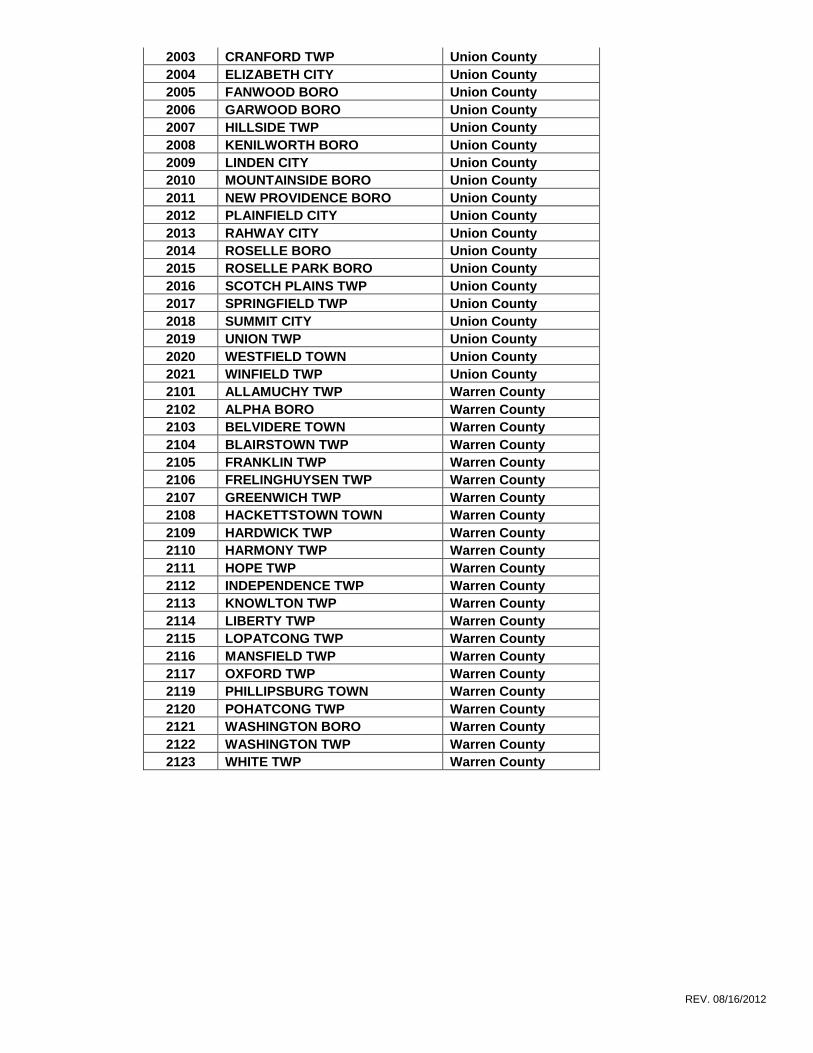
2003 CRANFORD TWP Union County
2004 ELIZABETH CITY Union County
2005 FANWOOD BORO Union County
2006 GARWOOD BORO Union County
2007 HILLSIDE TWP Union County
2008 KENILWORTH BORO Union County
2009 LINDEN CITY Union County
2010 MOUNTAINSIDE BORO Union County
2011 NEW PROVIDENCE BORO Union County
2012 PLAINFIELD CITY Union County
2013 RAHWAY CITY Union County
2014 ROSELLE BORO Union County
2015 ROSELLE PARK BORO Union County
2016 SCOTCH PLAINS TWP Union County
2017 SPRINGFIELD TWP Union County
2018 SUMMIT CITY Union County
2019 UNION TWP Union County
2020 WESTFIELD TOWN Union County
2021 WINFIELD TWP Union County
2101 ALLAMUCHY TWP Warren County
2102 ALPHA BORO Warren County
2103 BELVIDERE TOWN Warren County
2104 BLAIRSTOWN TWP Warren County
2105 FRANKLIN TWP Warren County
2106 FRELINGHUYSEN TWP Warren County
2107 GREENWICH TWP Warren County
2108 HACKETTSTOWN TOWN Warren County
2109 HARDWICK TWP Warren County
2110 HARMONY TWP Warren County
2111 HOPE TWP Warren County
2112 INDEPENDENCE TWP Warren County
2113 KNOWLTON TWP Warren County
2114 LIBERTY TWP Warren County
2115 LOPATCONG TWP Warren County
2116 MANSFIELD TWP Warren County
2117 OXFORD TWP Warren County
2119 PHILLIPSBURG TOWN Warren County
2120 POHATCONG TWP Warren County
2121 WASHINGTON BORO Warren County
2122 WASHINGTON TWP Warren County
2123 WHITE TWP Warren County
Top Related