


Languages
Pages
Legal


A Model-Based Approach to the Automatic
Extraction of Linear Features from Airborne
Images.
A. Katartzis, H. Sahli, V. Pizurica, J. Cornelis
Abstract
We describe a model-based method for the automatic extraction of linear features, like roads and paths, from aerial images. The paper
combines and extends two earlier approaches for road detection in SAR satellite images, and presents the modi�cations needed for the
application domain of airborne image analysis, together with representative results.
Keywords
Mathematical morphology, Markov random �elds, linear features, airborne images.
I. Introduction
THE identi�cation of linear features by means of digital image analysis is a generic task in remote sensing. Several
approaches have been proposed in the literature, most of them dealing with the problem of road extraction from
either synthetic aperture radar (SAR) images or optic (visible range) images. Usually they are based on two criteria: a
local criterion involving the use of local operators and a global criterion incorporating additional knowledge about the
structure of the objects to be detected. Local operators evaluate properties of the image by using either edge or line
detection [1] [2] [3] [4] or morphological operations [5]. The performance of these methods can be greatly increased by
using techniques that introduce some global constraints in the image analysis process. These techniques minimize a cost
function by using dynamic programming [3] [6], tracking [7] or the Bayesian framework [4] [8] [9].
In this paper we propose a method that combines both local and global criteria for the identi�cation of the medial axis
of roads and paths in aerial images [10]. Our work is part of the European pilot project 'Airborne Mine�eld Detection
in Mozambique', and its main objective is the identi�cation of mine�eld indicators that correspond to linear structures,
which designate safe passage areas [11]. The proposed method is model-based and follows certain assumptions concerning
the geometry and radiometry of the linear structures of interest. It is based on the combination of the concepts of two
previously published methods for road detection using SAR images (Chanussot and Lambert [5], Tupin et al. [4]).

Chanussot and Lambert proposed a simple and fast unsupervised method for road network extraction, based on a series
of morphological processing steps that do not require any threshold. The only parameters that have to be set correspond
to the model dimensions of the feature which has to be extracted. Unfortunately, the lack of contextual knowledge in [5]
results in partial detection of the road network, together with several spurious detections. On the other hand, the work
of Tupin et al. [4] uses both local and global techniques for linear feature extraction. The �rst part of their algorithm
performs a local detection of linear structures based on the fusion of the results from two line detectors, both taking into
account the statistical properties of speckle in SAR images. The masks of the line detectors have widths ranging from 1
to a maximal number of 5 pixels [4]. The produced candidate road segments, together with an additional set of segments
that correspond to all possible connections between them, are then organized as a graph and the road identi�cation is
solved by the extraction of the best graph labeling based on a MRF model for road like structures and a maximum a
posteriori (MAP) criterion.
Our approach consists of two steps. During a local analysis step, the detection of elongated structures is performed
using a set of morphological operators, similar to the ones proposed in [5], and a dedicated algorithm for line segment
extraction [12]. We introduce some modi�cations that enhance the performance of the morphological �ltering in the
case of heavily noisy environments and partially disconnected roads. The local analysis scheme can be extended for a
wide range of images and its computational complexity is relatively small, even in cases where the widths of the roads
vary from a few pixels, up to more than 20 pixels. A segment linking process is then performed in the global analysis
step of our method. This is based on the Bayesian framework of Tupin et al [4]. We present some modi�cations that
improve the road model, and make the process more robust and exible. These changes include the incorporation of
a new observation measure that re ects more eÆciently the likelihood value of each segment as belonging or not to a
road, a di�erent formulation of the potential functions that describe the probability distributions of our model, and the
reduction of the number of potential parameters.
The paper is organized as follows. Section II describes the morphological approach of [5] for road detection and our
local analysis scheme. In section III we present the MRF model-based formulation for road identi�cation and describe
the di�erences between our line grouping scheme and the approach of [4]. The validation of our method, which includes
the parameter setting and some representative results, is presented in section IV. Finally a discussion and directions for
future research are given in section V.

II. LOCAL ANALYSIS
A. The morphological approach of Chanussot and Lambert
The approach of Chanussot and Lambert for road detection in SAR images [5] is based on a geometrical and radio-
metrical road model. The model is based on three assumptions: 1) the roads appear on the image as thin, elongated
structures with a maximum width wmax, 2) they are locally rectilinear, with each road pixel belonging to a line segment
that is longer than a minimum length `0, and 3) each road segment is considered as a dark structure with respect to
its surroundings. All this information is integrated and extracted using mathematical morphology. A series of morpho-
logical operators is used in order to retain elongated structures with a speci�c width. The sequence of morphological
�ltering consists of: (a) an opening by reconstruction (removal of non at peaks), (b) a directional closing in 40 successive
directions (removal of non-linear valleys), (c) an opening (removal of remaining peaks), and (d) a closing Top-hat oper-
ator (removal of wide valleys). At every step, at structuring elements (SE) have been used, and their size is speci�ed
according to the a priori information about the road's maximum width and curvature. At a last stage, the roads are
extracted by a simple thresholding applied to the response of the morphological operators. Unfortunately, this approach
yields incomplete detection of the road network and several spurious detections.
B. The proposed scheme for local analysis
B.1 Morphological �ltering
We retain the advantages of the operators of [5], and at the same time introduce some modi�cations that �rst enhance
their performance under noise, and secondly, produce additional outputs that are used in the next steps of our method.
We suppose that the roads satisfy the �rst two assumptions of the road model of section II-A. As far as the third
assumption is concerned, because of the nature of our images we consider the roads as being bright structures with
respect to their background. This simply implies that each morphological operation must be replaced by its dual
counterpart (closing is replaced by opening and vice-versa).
In our case, the structuring elements used in the morphological �ltering steps (a), (c) and (d) are squares with
sizes wmax=4, wmax=4 and wmax, respectively. One of the proposed modi�cations refers to the directional operator
of step (b). According to [5], the elimination of non-linear structures can be obtained by using a directional opening
in a speci�ed number of successive directions. The resulting value at each pixel should be the supremum of all these
directional openings. Unfortunately, the minimum and maximum operations of the standard morphological opening are
very sensitive to noise and small variations in the shape of the objects (these changes can be small gaps in the road

segments). In order to overcome this problem, we use a soft morphological �lter based on weighted order statistics [13].
This operator is a soft opening with an order index equal to 5 and a linear, non- at SE of size `0, successively oriented in
32 di�erent directions. The SE consists of a hard center with a value equal to `0=2+1 and a soft boundary with linearly
decreasing values (from `0=2+1 to 1), starting from the center, towards both ends. These parameters have been chosen
empirically, based on several experiments, using a large set of test images. The result of the soft directional opening is
an image where bright structures that do not belong to any line segment with minimum length `0 have been eliminated,
and small gaps between linear objects are bridged. During this processing step, an orientation image is also produced
by assigning to each pixel the direction where the soft directional opening gave the maximum value.
As an additional last step, we use a closing with a square SE of size wmax=4, in order to homogenize the regions inside
the roads. The �nal result is considered as the response (R) of our morphological road detector. Figures 1 and 2 show
the grey value version of an airborne optical image with a size of 800 x 800 pixels and the morphological road detector's
response (negative image), respectively. In this particular example we have chosen wmax = 30 and `0 = 35.
B.2 Line segment extraction
One pixel width line segments are produced by extracting from the response image (R) the pseudo-medial axis of the
roads, over which we apply a line-following algorithm [12]. The pseudo-medial axis is found by performing the watershed
transformation on the response image. The objective of the line-following process is the creation of a list of line segments
with a minimum prede�ned length `min. Each medial-axis pixel is considered as the starting point of a line segment.
Pixels are added into a line segment by using a dedicated tracking algorithm, that follows a direction � indicated by
the orientation image. The line-following stops when an angle deviation greater than d� is reached. Figure 3 shows the
�nal result of this process (detected line segments) superimposed on the orientation image. The parameters `min and
d� are set to `min = `0=2 and d� = 30o, respectively.
III. GLOBAL ANALYSIS
The second part of our work concerns the reconstruction of the roads from the previously detected line segments.
Several methods have been developed for grouping lines using contextual constraints about the linear features of interest.
Markov random �eld theory provides an eÆcient framework to model these constraints [8] [14]. Our line grouping
approach is based on [4].

A. The line grouping approach of Tupin et al.
The method of Tupin et al. for line grouping [4] falls within the scope of the Bayesian framework. It is applied on
a set S of line segments, consisting of the set of detected line segments (Sdet) that are the result of a dedicated line
detection algorithm for SAR images, and all the possible connections between them (Scon). These additional segments
are produced by using certain connectivity criteria. The elements of S are then organized as a graph G = (S;A). To
each node i 2 S is associated a normalized segment length (`i 2 [0; 1]), an observation value di, which corresponds to
the mean line detection response value along the segment, and a label li = 1 if i belongs to a road, li = 0 otherwise. An
arc, Aij 2 A, between two nodes i and j, corresponds to a shared extremity. To each arc Aij is associated the angle
�ijmod� between the two segments. A neighborhood system is de�ned on G, with its cliques being all the subsets of
segments sharing an extremity. The neighborhood Ni of each node i is given by:
Ni =�j 2 S=9(k; p) 2 f1; 2g2;Mk
j=M
p
i; j 6= i
(1)
where Mkj, for k 2 f1; 2g, denote the endpoints of a segment j.
The identi�cation of the roads is carried out with an appropriate labeling of the graph, in accordance with the
observation process d = (d1; d2; :::; dm) (where m is the cardinality of S). A Markov random �eld is de�ned on the graph
and the optimum con�guration (labeling) l = (l1; l2; :::; lm) of the segments of S, given the observation process d, can be
estimated based on the Bayes rule and a MAP criterion that maximizes the posterior probability P (ljd). The conditional
probability distribution p(djl) depends on the observation measurements, whereas the prior probability of labelings P (l)
is based on a Markovian model of road-like objects. From the equivalence between MRF and Gibbs �elds, both of
them can be described with a set of potentials that associate an energy function to the di�erent con�gurations. The
minimization of this energy function gives the optimal solution to the problem.
Under the assumption that each observation di is only conditioned by the corresponding label li, the conditional
probability distribution p(djl) is expressed by:
p(djl) =
mYi=1
p(dijli) / exp
�
mXi=1
(V (dijli) + logZ0)
!(2)
where V (dijli) denotes the conditional potential of segment i and Z0 a normalization factor that ensures the condition
R1
0p(d = xjl)dx = 1. The potentials V (dijli) were chosen experimentally after a manual segmentation of roads and

depend on two parameters t1 and t2:
V (dij0) =
8>>>>>><>>>>>>:
0 if di < t1
di�t1
t2�t1if t1 < di < t2
1 otherwise
and V (dij1) = 0; 8 di (3)
The prior probability of labelings and the corresponding clique potentials re ect three main assumptions about the
road structure: (i) roads are long structures, (ii) they have low curvature, and (iii) intersections between roads are rare.
For every clique c, the de�ned clique potentials depend on the current con�guration:
� Null situation : 8i 2 c; li = 0; Vc(l) = 0 (4)
� Assumption (i) : 9!i 2 c=li = 1; Vc(l) = Ke �Kl`i(5)
� Assumption (ii) : 9!(i; j) 2 c2=li = lj = 1; Vc(l) = �Kl(`i + `j) +Kcsin(�ij) (6)
� Assumption (iii) : in all other cases; Vc(l) = KP
i=i2cli
(7)
Positive values for the parameters Ke and Kl ful�ll assumption (i) and favor long roads, whereas positive values for Kc
and K ful�ll the assumptions (ii) and (iii) of the road model, respectively.
B. The proposed scheme for line grouping
We propose a line grouping scheme that is an enhanced version of the method described in the previous section. The
main modi�cations include the incorporation of a new observation measure, the reduction of the number of potential
parameters and the improvement of the clique potential functions.
B.1 Graph creation
The graph structure G, associated to the augmented set of segments S, together with the attributes attached to it
are the same as in the scheme of [4], described in the previous section. We introduce a new observation �eld d that
depends both on the morphological road detection response and orientation information, and re ects more eÆciently
the likelihood value of each segment as belonging to a road. The observation di of each segment i is a function of a
saliency measure ri de�ned as:
ri = Ri=(j�i � �ij+ 1) (8)
where Ri and �i are the mean values, along the line segment, of the morphological road detection and orientation
responses (as described in section II-B.1) respectively, and �i is the line segment orientation. A high value ri for a

segment i, together with the presence of other segments with a high saliency in the neighborhood of i, are considered as
cumulated evidence that this segment is part of a road. The observation values di are de�ned as:
di = maxj2Ni
f(ri + rj)=2g (9)
The observation values d1; d2; :::; dm, associated to S, are then normalized between 0 and 1.
B.2 Conditional probability distribution
By assuming that the observation di is only conditioned by the corresponding label li, and that the dependencies
between the di�erent observations are exclusively determined by the dependencies between the labels li (as described
by the MRF model), the conditional probability distribution p(djl) can be derived from equation 2. Using the proposed
observations di (equation 9), manual segmentation of road images showed that road segments may have almost any
observation value d, while nonroad segments have observations with values smaller than a threshold t. As opposed
to the conditional potentials proposed in [4], the chosen potential functions that describe the conditional probability
distributions p(dijli) depend only on one parameter:
V (dj0) =
8>><>>:
d
tif d < t
1 otherwise
and V (dj1) = 0; 8 d (10)
Based on these functions, the normalization factor Z0 in equation 2 is found to be equal to Z0 = (1� t)(1=e)� t(1=e�1)
with e = exp(1).
B.3 Prior probability of labelings
A priori knowledge is introduced with the creation of a geometrical model of road-like structures. In our case, this
model is based on the three assumptions of [4] described in section III-A. We have modi�ed the form of the clique
potentials proposed in [4] by using a reduced number of potential parameters and by making a clear distinction between
the elements of Sdet and Scon, which provides additional a priori information about the nature of each segment. The
optimal con�gurations have long and collinear detected line segments with short connections between them. Every
clique contains one segment belonging to Sdet (with length `det), along with segments of Scon (with length `
con) that
share the same extremity. For every clique c, the chosen clique potentials have the following form:
� Null situation : 8i 2 c; li = 0; Vc(l) = 0 (11)
� Assumption (i) : 9!i 2 c ^ i 2 Sdet=li = 1; Vc(l) = K1 + 1� `det
i+ logZ0
(12)

� Assumption (ii) : 9!(i; j) 2 c2 ^ i 2 Sdet; j 2 Scon=li = lj = 1;
Vc(l) = sin(�ij) + 1� `det
i+ `
con
j+ 2logZ0
(13)
� Assumption (iii) : in all other cases, Vc(l) = K2
Pi=i2c
li(14)
By choosing K1 > 0 in equation 12 we penalize short roads (assumption (i) in section III-A), i.e. the clique potential is
high for a clique with only one isolated segment, except when this isolated segment has a high normalized length `det
i
(close to 1). High values of K1 favor more connected con�gurations. Equation 13 satis�es assumption (ii) of section
III-A and at the same time penalizes con�gurations with short detected and long connecting segments. Finally, K2 > 0,
in equation 14, has the same properties as the parameter K in equation 7. The additional parameters logZ0 and 2logZ0,
in equations 12 and 13 respectively, are factors that facilitate the comparison between the clique potential values and
the conditional potentials of the null con�gurations (where all the segments of the current clique are labeled as 0). In
the case of a clique with one segment labeled as 1, the factor K1+1� `det
iin equation 12 is directly compared with the
conditional potential component V (dij0) of the current segment i. In the case of a clique with two segments i, j labeled
as li = lj = 1, the factor sin(�ij) + 1� `det
i+ `
con
jof equation 13 is compared with the sum of the conditional potential
components V (dij0), V (dj j0).
B.4 Posterior probability - Energy minimization
The posterior probability P (ljd) can be also expressed in terms of a global energy function U(ljd) (P (ljd) =/
exp(�U(ljd))), which can be deduced from the potentials functions:
U(ljd) =
mXi=1
V (dijli) +Xc2C
Vc(l) (15)
The MAP con�guration of the line segments is estimated by minimizing the energy function U(ljd). As minimization
scheme, a simulated annealing specially adapted to our problem is used [12]. We chose an eÆcient label generation
mechanism in order to speed up the evolution of the system towards the optimal solution (global minimum). Instead of
sequentially updating the label of each node, we consider three adjacent segments and apply the Metropolis acceptance
criterion [15] to each of their eight possible con�gurations. Based on the conjecture that it is not possible to have a
connecting segment with label li = 1 if one of the adjacent detected segments has label lj = 0, we reject beforehand
con�gurations of this type. For the annealing process, we used the polynomial-time cooling schedule proposed in [15].

IV. VALIDATION
A. Parameter setting
In this section, we investigate the parameters that in uence the probability distributions and their corresponding
potential functions. Our scheme for parameter setting is inspired from the one presented in [4]. As a reference, we will
use a set of three connected segments s1, s2, s3 (s1; s3 2 Sdet and s2 2 Scon). By comparing the energy components of
two possible con�gurations of these segments, we can derive the accepted range of the parameter K1.
� "Connected" con�guration: l1 = l2 = l3 = 1.
Ucon = 2K1 + sin�12 + sin�23 + 4� 2`1 � 2`3 + 2`2 + 6logZ0 (16)
� "Unconnected" con�guration: l1 = l3 = 1 and l2 = 0.
Uuncon = V (d2j0) + 4K1 + 4� 2`1 � 2`3 + 4logZ0 (17)
The energetic variation �U = Ucon �Uuncon should be positive in the case of a long connecting segment s2 (`2 ! 1)
with a poor observation value (V (d2j0)! logZ0), even if the three segments are perfectly aligned. This condition limits
the connecting power of the a priori model in poor observation areas. Based on the restriction �U > 0, the following
condition should be ful�lled:
K1 <2 + logZ0
2(18)
The parameter K2 has been empirically set to a value equal to 0.1. Finally, the optimal value of the parameter t (in
equation 10), for the type of airborne images used in our application, is found to be around 0.15 (logZ0 � �0:89).
B. Results
This section demonstrates the performance of our method in two diÆcult cases of airborne images. The �rst image
contains roads with a big variety of widths, while the second one has small paths in a heavily textured environment. In
both examples, the road detection results have been produced using the following values for the potential parameters:
t = 0:15, K1 = 0:5 and K2 = 0:1.
Figure 4 shows the result of our method related to the airborne image of �gure 1. Most of the false-alarm detections
of �gure 3 have been suppressed, whereas the linear features corresponding to roads and paths have been successfully
reconstructed, independently of their size. Figure 5 illustrates the in uence of the angular information in the de�nition
of the saliency measure r (equation 8). The choice of a saliency measure depending only on the mean response value
along each segment (ri = Ri) produces several spurious detections due to imperfections in the response image.

A second example is presented in �gure 6. The image has a size of 800x800 pixels and represents a heavily textured
scene, with several small paths that are partially disconnected, mainly because of image degradation. The parameters
used in the local analysis step are the following: wmax = 5, `0 = 20, `min = `0=2 and d� = 30o. The �nal result,
presented in �gure 7, contains most of the linear features of interest together with a small number of wrongly classi�ed
line segments. Finally, we demonstrate the importance of the introduced soft morphological operators during the local
analysis phase. Figure 8 represents the detected linear structures from �gure 6, using merely the morphological operators
of Chanussot and Lambert [5], without the proposed modi�cations. The paths in the image have been partially detected,
mainly due to the fact that the result of the morphological �ltering contains several disconnected linear regions, which
are gradually vanished during the ooding process of the watershed transformation (extraction of the pseudo-medial
axis of the roads).
The computational time of our method is rather demanding, mainly because of the optimization step (simulated
annealing) of section III-B.4. Nevertheless, the proposed optimization scheme is stable and converges, in most cases
that were investigated, to a global minimum solution, independently of the initial realization of labelings. For a 800 x
800 image on a Pentium III at 500MHz, the local analysis phase lasts around 5 min. Due to the eÆciency of our line
detector, for our test set of images, the total number of road segment candidates is not more than 1500. For this number
of segments the labeling stage lasts approximately 10 min.
V. DISCUSSION - CONCLUSIONS
We describe a model-based technique for linear feature extraction, in digitized airborne images, which combines both
local and global criteria, and illustrate its application on the problem of road and path detection. Its main advantage is
the good detection performance in heavily textured environments along with its ability of identifying elongated structures
independently of their size. It can be considered as the combination and extension of two earlier approaches [5] [4].
As far as the local analysis step is concerned, the improvement of the morphological �ltering scheme of [5], mainly due
to the use of a soft operator, together with the proposed line-following algorithm, result in a better detection of roads
with a large variety of sizes, and in the reduction of spurious line segments, even in the presence of heavy noise. Due to
the good performance of our line detector, the produced candidate road segments are long and not too numerous. This
decreases signi�cantly the complexity of the labeling process. The proposed global analysis stage, although it has many
similarities with the one in [4], contains some important modi�cations that make it more exible and robust. These
modi�cations include the incorporation of a new observation measure that re ects more eÆciently the likelihood value
of each segment, the reduction of the number of potential parameters, and �nally the use of di�erent potential functions

that represent better the properties of the geometrical road model.
One of the most important limitations of our method is that it is not entirely unsupervised, due to the setting of
three parameters (t, K1, K2), all of them concerning the connection step. Nevertheless, the proposed ranges of these
parameters, give very good results for the class of environments illustrated in �gures 1 and 6, independently of the size
of the linear features to be extracted. Further analysis should be carried out towards the problem of identifying road
segments with high curvature, especially when the curvature is high compared to the maximum road width found in
the image, and towards the choice of a more eÆcient skeletonization process for the extraction of the road medial axis.
Another interesting aspect for investigation is the incorporation of color information as an extra attribute, in order to
further decrease the number of false-alarm detections.
Acknowledgments
The research is part of the European Pilot Project: "Airborne Mine�eld Detection in Mozambique" (REG/661-
97/2,DG VIII). (Partners: ITC(N), RMA(B), Geograph(P), EOS(UK), Eurosense(B), Aerodata(B), CAE Aviation(L),
VUB(B)). It was funded by the European Commission (DG8) and the involved member states. The authors would like
also to thank Prof. E. Nyssen (VUB) for his comments.
References
[1] J. Canny, \A computational approach to edge detection," IEEE Trans. Pattern Anal. Machine Intell., vol. 8, pp. 679{698, Nov. 1986.
[2] Y. T. Zhou, V. Venkateswar, and R. Chellapa, \Edge detection and linear feature extraction using a 2-d random �eld model," IEEE
Trans. Pattern Anal. Machine Intell., vol. 11, pp. 84{95, Jan. 1989.
[3] M. A. Fischler, J. M. Tenenbaum, and H. C. Wolf, \Detection of roads and linear structures in low resolution aerial imagery using a
multisource knowledge integration technique," Comput. Graph. Image Processing, vol. 15, pp. 201{223, no 3 1981.
[4] F. Tupin, H. Maitre, J. F. Mangin, J. M. Nicolas, and E. Pechersky, \Detection of linear features in SAR images: Application to road
network extraction," IEEE Trans. on Geoscience and Remote Sensing, vol. 36, pp. 434{453, Mar. 1998.
[5] J. Chanussot and P. Lambert, \An application of mathematical morphology to road network extraction on SAR images," Proc.
International Symposium on Mathematical Morphology, Amsterdam, pp. 399{406, 1998.
[6] N. Merlet and J. Zerubia, \New prospects in line detection by dynamic programming," IEEE Trans. Pattern Anal. Machine Intell.,
vol. 18, pp. 426{431, Apr. 1996.
[7] D. Geman and B. Jedynak, \An active testing model for tracking roads in satellite images," IEEE Trans. Pattern Anal. Machine Intell.,
vol. 18, pp. 1{14, Jan. 1996.
[8] J. L. Marroquin, \A Markovian random �eld of piecewise straight lines," Biological Cybern., vol. 61, pp. 457{465, 1989.
[9] M. Barzohar and D. B. Cooper, \Automatic �nding of main roads in aerial images using geometric-stohastic models and estimation,"
IEEE Trans. Pattern Anal. Machine Intell., vol. 18, pp. 707{721, Jul. 1996.
[10] A. Katartzis, V. Pizurica, and H. Sahli, \Application of mathematical morphology and Markov random �eld theory to the automatic
extraction of linear features in airborne images," Proc. International Symposium on: Mathematical Morphology and its Applications to
Image and Signal Processing V, California, USA, pp. 405{414, 2000.
[11] L. van Kempen, A. Katartzis, V. Pizurica, J. Cornelis, and H. Sahli, \Digital signal/image processing for mine detection part1: Airborne
approach," Proc. MINE '99, Euroconference on: Sensor systems and signal processing techniques applied to the detection of mines and
unexploded ordinance, Firenze, Italy, pp. 48{53, 1999.
[12] A. Katartzis and H. Sahli, \A model-based approach to the automatic extraction of linear features from airborne images, using
mathematical morphology and MRF theory," Technical report,VUB: IRIS-TR-0062, 2000.
[13] P. Kuosmanen and J. Astola, \Soft morphological �ltering," Journal of Mathematical Imaging and Vision, vol. 5, pp. 231{262, 1995.
[14] S. Krishnamachari and R. Chellapa, \Delineating buildings by grouping lines with MRFs," IEEE Trans. on Image Processing, vol. 5,
pp. 164{168, Jan. 1996.
[15] E. H. L. Aarts, Simulated annealing and Boltzmann machines, John Wiley & Sons Ltd., 1989.
Figures - Captions
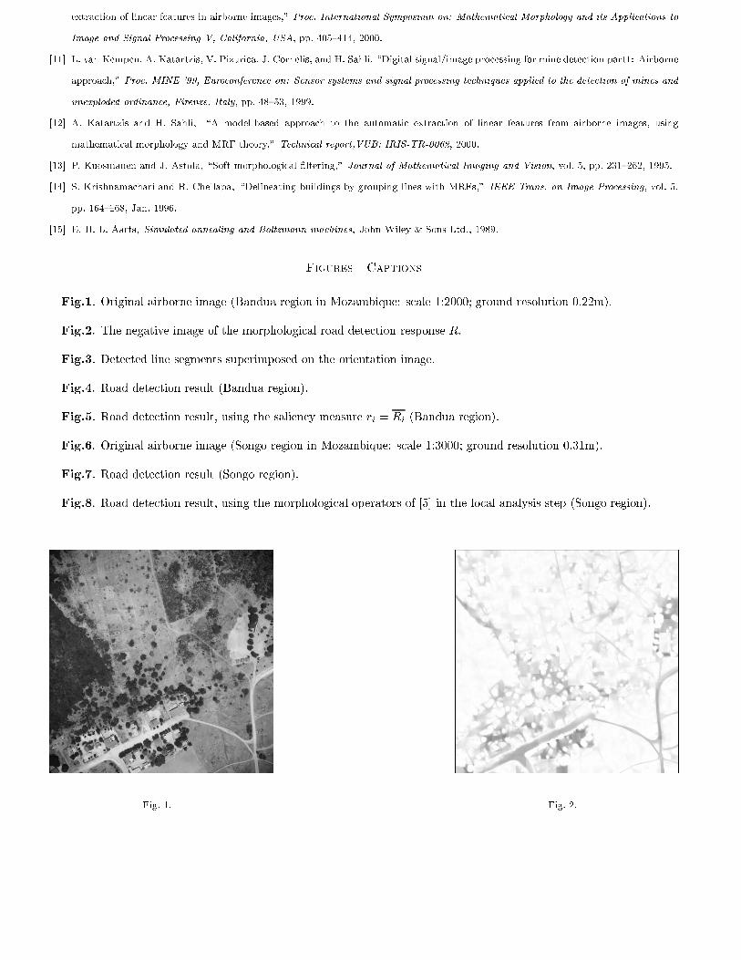
Fig.1. Original airborne image (Bandua region in Mozambique: scale 1:2000; ground resolution 0.22m).
Fig.2. The negative image of the morphological road detection response R.
Fig.3. Detected line segments superimposed on the orientation image.
Fig.4. Road detection result (Bandua region).
Fig.5. Road detection result, using the saliency measure ri = Ri (Bandua region).
Fig.6. Original airborne image (Songo region in Mozambique: scale 1:3000; ground resolution 0.31m).
Fig.7. Road detection result (Songo region).
Fig.8. Road detection result, using the morphological operators of [5] in the local analysis step (Songo region).
Fig. 1. Fig. 2.
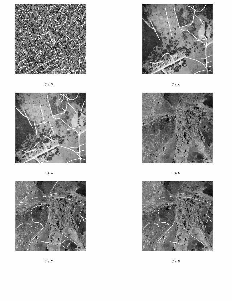
Fig. 3. Fig. 4.
Fig. 5. Fig. 6.
Fig. 7. Fig. 8.
Top Related