


Languages
Pages
Legal

Explosive Site Plan
CHARLIE AREA SUPPLEMENTAL MEC SAMPLING
Fort McClellan, AL
DECEMBER 2009
Prepared by
U.S. Army and Engineering Center, Huntsville

i
TABLE OF CONTENTS Section Page 1.0 SITE ..................................................................................................................... 1
2.0 ANTICIPATED DATES ........................................................................................ 1
3.0 PURPOSE ............................................................................................................ 1
4.0 SITE BACKGROUND AND CURRENT CONDITIONS........................................ 1
5.0 EXECUTING AGENCIES ..................................................................................... 2
6.0 SCOPE OF INVESTIGATIVE/CHARACTERIZATION ACTION .......................... 2
7.0 SAFETY CRITERIA ............................................................................................. 3
8.0 METHODS OF DISPOSAL .................................................................................. 4
APPENDIX A – MAPS ..................................................................................................A1
APPENDIX B – CALCULATION SHEETS ..................................................................B1

1
1. Site: a. Name: Fort McClellan, Charlie Area b. State: Alabama c. This Supplemental Munitions and Explosives of Concern (MEC) Sampling is being performed under the Comprehensive Environmental Response, Compensation, and Liability Act of 1980 (CERCLA), as amended by the Superfund Amendments and Reauthorization Act of 1986 (SARA), and is part of the overall Remedial Action Process. Subsequent removal responses may be dictated in the future during the remainder of the remedial response process, as determined by action memoranda or other decision documents. Based on the results of this characterization and subsequent decision document, an Explosives Safety Submission (ESS) will be submitted in accordance with DoD 6055.09-STD.
2. Anticipated Dates: a. Start: 03/25/10 b. Complete: 05/03/10
3. Purpose:
a. Supplemental sampling for MEC and subsequent document revision in order to finalize the existing Draft Final Charlie Area Engineering Evaluation/Cost Analysis (EE/CA) and all necessary activities required to accomplish this objective.
b. Achieve regulatory and stakeholder concurrence so that Fort McClellan redevelopment can continue.
c. Clarifies that qualified EOD Technology, Inc. (EODT) personnel will perform all explosive ordnance disposal (EOD) activities at the site.
4. Site Background and Current Conditions:
a. Fort McClellan has been used for artillery training of troops and the National Guard as early as 1898 to early WW II. In 1941, McClellan became the site of the Chemical Corps Training Command. In 1962, the U.S. Army Combat Developments Command Chemical Biological-Radiological Agency moved to Fort McClellan. In 1973, the Chemical Corps School along with the U.S. Army Combat Developments Command Chemical Biological-Radiological Agency was moved to Edgewood Arsenal. In 1979, the U.S. Army Chemical Corps School re-established along with a Training Brigade for Basic Training. Fort McClellan was closed in September 1999 under the BRAC program.
b. The US Army Corps of Engineers (USACE) contracted to complete site characterization activities and EE/CA document production for the site in 2002.

2
The US Fish and Wildlife Service (USFWS) review of the Draft Final EE/CA (December 2004) resulted in postponement of the final EE/CA. USFWS concerns have been resolved; however the Final EE/CA is postponed pending completion of supplemental MEC sampling requirements requested by the Alabama Department of Environmental Management (ADEM).
5. Executing Agencies:
a. Fort McClellan Transition Force, Fort McClellan, AL b. US Army Corps of Engineers, Huntsville Center c. EODT
6. Scope of Investigative/Characterization Action: a. USACE examined the existing EE/CA information in order to determine potential
data gaps. Six (6) areas located in the Charlie Area at Fort McClellan are proposed for supplemental MEC sampling in order to complete the Charlie Area EE/CA. Areas 1-4 in the Risk Sector FWS-1L-FM, Area 5 in Risk Sector FWS-2L-FM, and Area 6 located southwest of the originally investigated EE/CA Sector FWS-3M-FM. The sampling will consist of digging anomalies along transects and within grids. The USACE analysis resulted in the following sampling:
Reacquisition and investigation of anomalies in six (6) grids (C102, C116, C118, C131, C140 and A044) that were not previously investigated, in Areas 1 and 3.
Investigation of anomalies in an additional two (2) new grids in Areas 1 and 2.
Investigation of new transects in Areas 1, 2, 3, 4, 5, and 6
b. Table 7-1 displays the Areas, and the munitions with the greatest fragmentation distance (MGFD) that are included in this Explosives Site Plan (ESP). This ESP only addresses those areas shown in orange, and delineated as “Sampling Boundaries” on Figure 6-1.
c. The purpose of this ESP is to ensure that all areas included in this investigative action are covered by this ESP.
d. The investigative action will identify possible future remedial action areas for this
site.
e. The selected investigative technique for conducting the investigation for contaminants is a surface sweep and intrusive investigation of potential MEC,

3
debris, and other contaminants to depth of detection. If heavy equipment is used, excavation will stop 1 foot from the anomaly, and then be manually dug by hand.
f. All areas will be investigated either using geophysical mapping (grids), or analog
method (transects). 7. Safety Criteria:
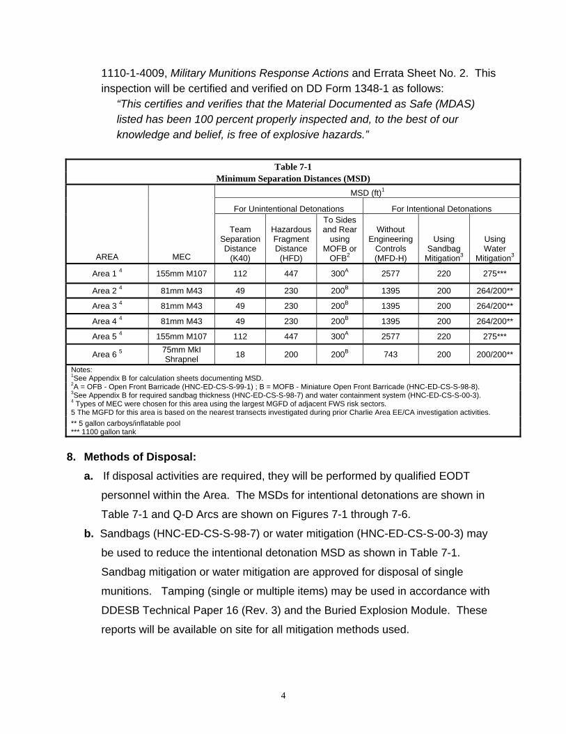
a. The munitions with the greatest fragmentation distance (MGFD) in Areas 1-5 are based on the nearest FWS risk sectors that are currently included in the ESS for the MEC Removal Action at the Choccolocco Area, U.S. Fish and Wildlife Transfer, and its amendments. The MEC possibly associated with Area 6 is not available. Therefore, the MGFD is based on the nearest transects investigated during prior Charlie Area EE/CA investigation activities. The MGFDs are identified in Table 7-1. During the course of this investigation, if a MEC item with a greater fragmentation distance is encountered, the minimum separation distance (MSD) will be adjusted in accordance with DDESB Technical Paper 16 (Revision 3), operations will continue, and an amendment to this ESP submitted expeditiously for approval. The Quantity-Distance (Q-D) Arcs for all areas are shown in Appendix A, Figures 7-1 through 7-6.
b. See Appendix B for Fragmentation Data Sheets. c. See Table 7-1 for Minimum Separation Distances. d. Any occupied buildings or public roadways in the MSD areas during MEC
operations will be evacuated and/or roadways blocked to prevent non-essential personnel from entering during the conduct of MEC operations. Alternatively, engineering controls may be used as follows: Miniature Open Front Barricade (MOFB) or Open Front Barricade (OFB) for intrusive operations, the Buried Explosion Module (BEM) (see DDESB Technical Paper 16), Sandbag Mitigation or Water Mitigation for disposal operations (see notes in Table 7-1 for appropriate reports governing the use of these engineering controls). The appropriate reports will be available on site for all engineering controls used.
e. All Material Potentially Presenting an Explosive Hazard (MPPEH) and munitions
debris (MD) will be inspected, certified, verified and disposed of in accordance with DOD Instruction 4140.62, Management and Disposition of MPPEH and EM
4
1110-1-4009, Military Munitions Response Actions and Errata Sheet No. 2. This inspection will be certified and verified on DD Form 1348-1 as follows:
“This certifies and verifies that the Material Documented as Safe (MDAS) listed has been 100 percent properly inspected and, to the best of our knowledge and belief, is free of explosive hazards.”
Table 7-1 Minimum Separation Distances (MSD)
MSD (ft)1
For Unintentional Detonations For Intentional Detonations
AREA MEC
Team Separation Distance
(K40)
Hazardous Fragment Distance
(HFD)
To Sides and Rear
using MOFB or
OFB2
Without Engineering
Controls (MFD-H)
Using Sandbag
Mitigation3
Using Water
Mitigation3
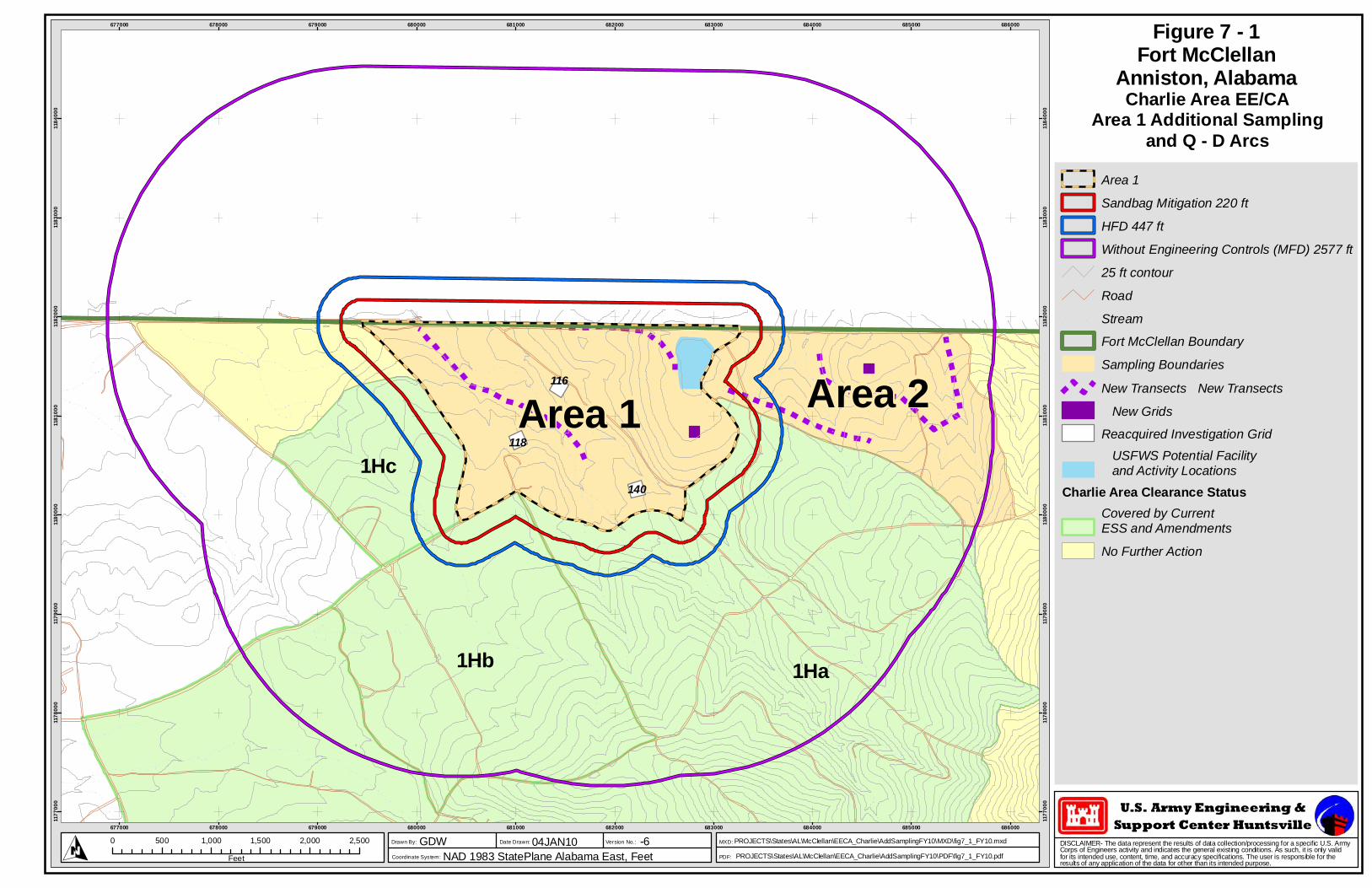
Area 1 4 155mm M107 112 447 300A 2577 220 275***
Area 2 4 81mm M43 49 230 200B 1395 200 264/200**
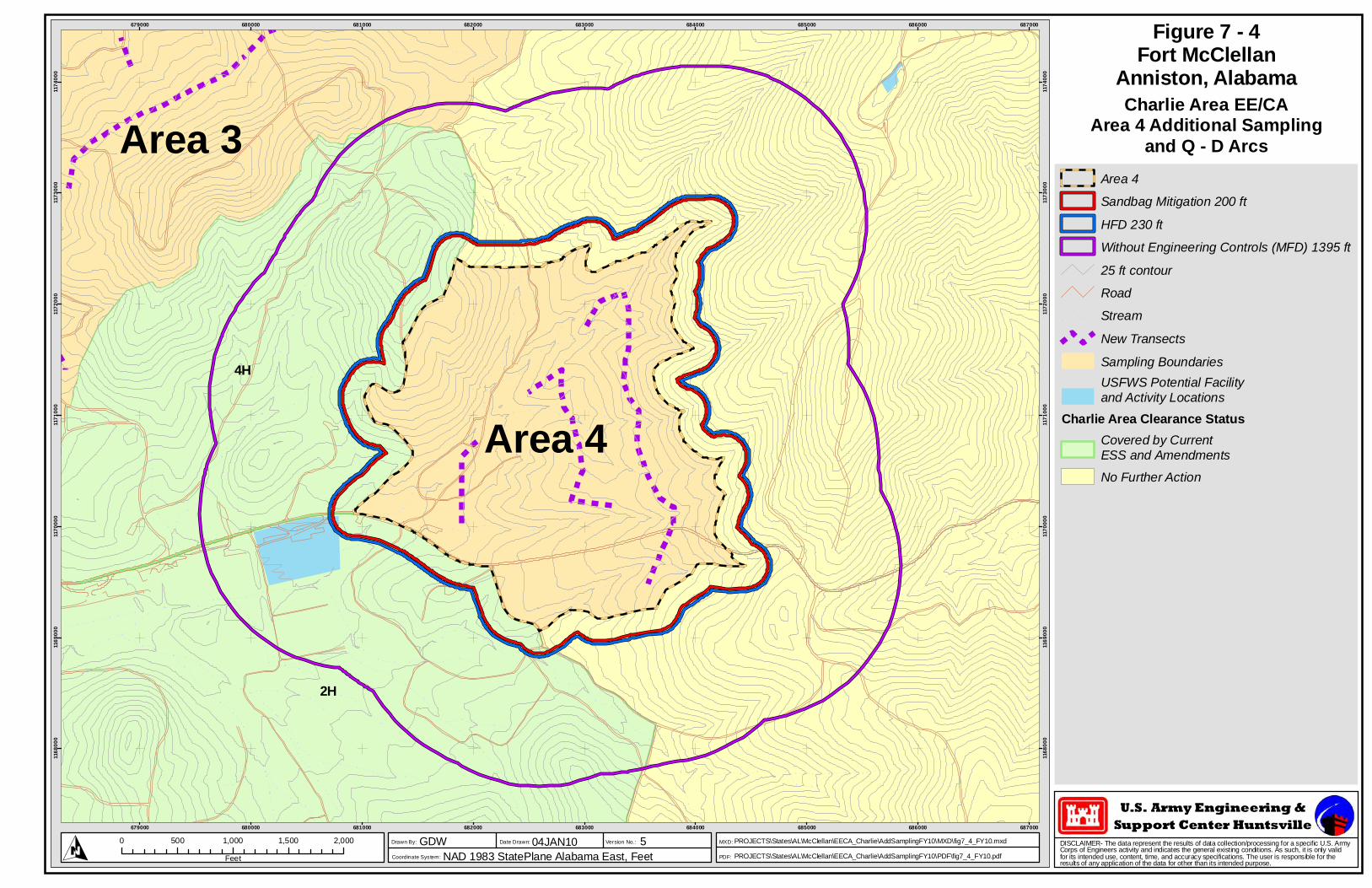
Area 3 4 81mm M43 49 230 200B 1395 200 264/200**
Area 4 4 81mm M43 49 230 200B 1395 200 264/200**
Area 5 4 155mm M107 112 447 300A 2577 220 275***
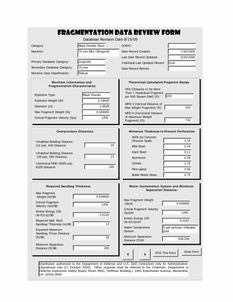
Area 6 5 75mm MkI Shrapnel
18 200 200B 743 200 200/200**
Notes: 1See Appendix B for calculation sheets documenting MSD. 2A = OFB - Open Front Barricade (HNC-ED-CS-S-99-1) ; B = MOFB - Miniature Open Front Barricade (HNC-ED-CS-S-98-8). 3See Appendix B for required sandbag thickness (HNC-ED-CS-S-98-7) and water containment system (HNC-ED-CS-S-00-3). 4 Types of MEC were chosen for this area using the largest MGFD of adjacent FWS risk sectors. 5 The MGFD for this area is based on the nearest transects investigated during prior Charlie Area EE/CA investigation activities.
** 5 gallon carboys/inflatable pool *** 1100 gallon tank
8. Methods of Disposal:
a. If disposal activities are required, they will be performed by qualified EODT
personnel within the Area. The MSDs for intentional detonations are shown in
Table 7-1 and Q-D Arcs are shown on Figures 7-1 through 7-6.
b. Sandbags (HNC-ED-CS-S-98-7) or water mitigation (HNC-ED-CS-S-00-3) may
be used to reduce the intentional detonation MSD as shown in Table 7-1.
Sandbag mitigation or water mitigation are approved for disposal of single
munitions. Tamping (single or multiple items) may be used in accordance with
DDESB Technical Paper 16 (Rev. 3) and the Buried Explosion Module. These
reports will be available on site for all mitigation methods used.
5
c. Two ATF Type II magazines have been sited for the existing approved ESS,
Amendment 4, “Choccolocco Area U.S. Fish and Wildlife Transfer of Fort
McClellan, Alabama “ dated June 2009. These magazines will be utilized during
the efforts being performed under this ESP, and all criteria approved in the
existing ESS shall apply. A copy of the referenced ESS (in addition to this ESP)
shall be available on-site during project activities.
d. Consolidating multiple MEC may be used. If MEC is deemed acceptable to
move by qualified personnel as specified in the approved Work Plan, it may be
moved to a collection point within the area and items may be disposed of using a
consolidated shot in accordance with US Army Engineering and Support Center,
Huntsville (USAESCH) publication, Procedures for Demolition of Multiple Rounds
(Consolidated Shots) on Ordnance and Explosives (OE) Sites, dated March
2000 (a copy of this report will be available on site). Items at a collection point
will be positioned in accordance with this report and the maximum total net
explosive weight (NEW) at a collection point will not exceed the total NEW for
which the K40 overpressure distance is less than or equal to the unintentional
detonation MSD for the area as shown in Table 7-1. The maximum total NEW
for a consolidated shot will not exceed the total NEW for which the K328
overpressure distance is less than or equal to the Horizontal Distance of
Maximum Weight Fragment (MFD-H) for the area as shown in Table 7-1.

A1
APPENDIX A MAPS

U.S. Army Engineering &Support Center Huntsville
DISCLAIMER- The data represent the results of data collection/processing for a specific U.S. ArmyCorps of Engineers activity and indicates the general existing conditions. As such, it is only validfor its intended use, content, time, and accuracy specifications. The user is responsible for theresults of any application of the data for other than its intended purpose.
PDF:
MXD:
Coordinate System:
Drawn By: Date Drawn: Version No.:
!
!
!
!
!
!! ! ! !
!
!
!
!
!
!!
!! !
!
!
!!
!!
!
!
!
!
!
!!
!
!!
!
!
!!
!
!
!
!
!
!
!
!
!
!
!
!
!
!!
!
!
!
!
!
!
!
!
!
!
!
!
!
!
!
!
!
!
!
!
!
!!
!
!
!
!
!
!
!
!
!
!
!
!
!
!!
! !!
!
!
!
!! !
!
!
!
!
!
!
!
!!
!
!!
!
!
!
!
!
!
!
!
!
!
!
!
!
!
!
!
!
!
!
!
!
!
!
!!
!
!
!
!
!
!
!
!
!
!
!
!
!
!
!
!
!
!
!
!
!
!
!
! ! !
!
!
!
!
!
!
! !
!
!! !
!
!
!
!
!
!
!
!
!
!
!
!
!
!!
!
!
!
!!
!!
!
!!
!
!!
!
!
!
!
!
!
!
!
!
!
!
!
!
!
!
!
!!
!
!
!
!
!
!
!
!
!
!! !
!
!
!
!!
!
!
!
!
!
!
!
!
!
!
!
!
!
!
!
!
!
!
!!
!
!!
!
!
!
! !
!
!
!! !!
!
!
!
!
!
!!
!
!
!
!
!
!
! !
!
!
! !
!
! !
!!
!
!
!
!
!
!
!
!
!
!
!!
!
! !
!
!
!
!!
!
!
!
!
!
!
!
!
!
!
!
!
! !
!
!
!!
!
!
!
!
!!
!!
!
!
!
!
!
!
!
!
!
!!
!
! !
!
!
!!!
!
!
!
!
!!
!
!
!
!
!
!
!!
!!
!
!!
!
!
!!
!
!
!
!
!
!
!
!
!!
! !
!!
!
!! !
!
!
!
!
!
! !
!
!
!
!
!
!
!
!
!
!
!
!
!
!
!
!
!
!
!
!!
!
!
!
!
!! !
!
!
!
!
!
!
!!
!
!!
!
!!
!
!
!
!
!
!!
!
!
!
!
!
!
!
! !
!
!
!
!
!!
!
!
!
!! ! !!! !
!
!!!!
!
!!
!
!!! !
!!!
!!!!
!
!
!
!
!
!
!
!
!
!
!
!
!
!
!
!!
!
!
!
!
!
!
!
!
!
!
!!
!
!!!
!
!
!
!
!
!
!
!
!
!
!
!
!
!
!
!
!
!
!
!!
!
!
!
!
!
!
!
!
!
!
!
!
!
!
!
!
!
!
!
!
!
!! !!
!
!
! !
!
!
!
!
!
!
!
!
!
!
!
! !
!
!
! !
!!
! !!
!
!
!
!
! !
!
!
! !
! !
!!
!!
!
!
!
! !!
!
!
!
!!
!!!
!
!!
!
!
!
!! !
!
!
!
! !
!
!
!
!
!!
!
!
!
!
!
!
!
!
!!
!
!
!!
!
!!!
!!!
!
!!
!!
!
!
!
!
!
!
!
!
!
!
!!
!
!
!
!
!
!
!
!
!
!
!
!
!
!
!
!
!
!
!
!!
!
! !!!
!
!
!
!
!
!
!
!
!
!
!
!
!
!
!
!
!
!
!
!!
!
!
!
!
!
!
!
!
!
!
!
!
!
!
!
!! !
!
!
!
!
!
!
!
!
!
!
!
!
!
!! !
! !!
!
!
!
!
!
!
!
!
!
! !!
!
!
!
!
!!
!
!
!!
!
!
!
!! !
!
!
!
!!
!
!
!
!
!
!
!
!!
!
! !
!
!!
!
!
!
!
!
!
!
! !
!
!
!
!
!
!
!
!
!
! !!
!
!
!
!!
!
!
!
!!
!
!
! !
!
!
!
!
!
!
!
!
!!! !! !
!
!!
!
!!
!
!
!
!
!!
!!
! !
!
!
!
!
!!
!
!
! !!
!
!
!
!
!
!!
!!!
!
!
!
!
!
!
!
!
!
! !
!!
!
!
!
!
! !
!
!
!!
!
!
!
!
! !
!
!
!
!
!
!
!
!
!
!
!
!!
!
!
!
!
!
! !
!
!
!
!
!
!
!!
!
!
! !
!
!
!
!
!
!
!
!
!
!
!
!
!
!
!!
!! !
!
!
!
!
!
! !!
!
!
!
! !
!
! !!!
!
!
!
!
!
!
!
!
!!!
!
!
!!! !
!
!
!
!
!
!
!
!
!!
!
!
!
!
!
!
!
!
!
!
!
!
!
!
!
!
!!!
!
!!
!
!
!
!
!
!
!
!
!
!
!
!
!
!
!!
!
! !
!
!
!
!
!
!
!
!
!
!
!
!
!
!
!
!
!
!
!
!
!
!
!
!
!
!
! !!!
!
!
!
!
!
!
!
!
!
!!
!
!
!
!
!
!
!
!
!
! !!!
!
!
!
!
!!
!
!
!
!
!
!
!
!
!
!
!
!
!
!
!! !!
!
!
!
!
!
!
!!
! !!
!
!
!!
!
!
!
!
!
!
!
!!
!
!
!
!
! !
!
!
!
!
!
!
!!
!
!
!!
!
!
! !
!
!
!
!
!
!
!!
!
!
!
!
!
!
!!
!
!
!!!!
!
!
!
!
!
!
!
!
!! !
!
!
!
!
!!
!!
!
!
!
!
!
!
!!
!!! !
!
!
!
!
!
!
!
!!
!
! !
!
!
!! !
!!
!
!
!
!
!
!!
!
!
!
!
!
!
!! !
!!
!
!
!
!
!
!
!!
!
!
!!
!
!!
!
!
!
!
!!!!
! !
!
!
!
!
!
!
!
!
! !!
!!
!
!
! !
!
!
!
!
!
!
!
!
!
!
!
!
!
!
!
!
! !!
!
!!
!
!
!
!
!
!
!
!
!
!
! !
!
!
!
!!
!
!
!
!
!
!
!
!
!
!
!
!
!
!
!
!!
!
!
!
!
!
!
!
!
!
!
!
!
!
!
!
!
!
!
!
!
!
!
!
!
!
!
!
!
!
!
!
!
!
!
!
!
!
!
!
!
!
!
!
!
!
!
!
!
! ! !
!
!
!
!
!!
!
!
!
!
!
!
!
!
!
!!
!
!
!
!
!
!
!!
!
!
!
!
!!
!
!
!!
!
!
!
! !!!
!!
! !
!
!
!
!
!
!
!
!
!
!!
!
!
!!
!
!
!
!
!
!
!
!
!
!! ! !
!
!
!
!
!
!
!
!
!
!
!
!
!
!
!
!
!
!
!
! !!
! !
!
!
!
!
!
!!
!
!
!
!
!
!!
!
!
!
!
!
! !
!
!!
!
!
!
!
!
!
!!
!
!
!
!
!!
!
!
!
!
!!
!
!
!
!
!
!
!
! !
!
!
!
!
!
!
!
!
!
!
!
!
!
!!
!
! !
!
!
!
!!
!!
! !!
!
!
!
!
!!
!
!
!
!
!
!
!
!
!
!
!
!
!
!
!!
!
!
!!
!
!
!
!
!
!
!
!
!
!
!
!
!
!
!
!!!
!
!
! !
!
!
!
!
!
!
!
!
!
!
!
!
!
!!
!
!
!
!
!
!
! !
!
!
!
!
!
! !!!
!!!
!
! !
!
!
!
!
!
!
!
!
!!
!
!
!!
!
!
!
!
!
!
!
!!
!
!
!
!
!
!!
!!
!
!
!
!
!
!
!
!!
!! ! !
!
!
!
!
!
!
!
!
!!
!
!
!
!
!!!
! !
!!
!
!
!
!!
!
!
!
!
!
!
!
!
!
!
!
!
!
!
!
!
!
!
!
!
!
!
!
!
!
!
!
!
!
!
!
!
!
!
!
!
!
!!!
!
!
! !
!
!
!
!!
!
!
!
!
!!
!
! !!
!!
!!
!
!
!
!
!!!
!
!
!
!
!
!
!
!
!
!!
!
!! !
!
!
!
!
!
!
!
!
!
!
!!
!
!
!
!
!
!
!
!
!
!
!
!
!!
!!
!
!!
!!
!
!
! ! !
!
!
!
!!
!
!
!
!
!
!
!
!
!!
! !
!
!
!
!
!
!
!
!
!
!
!
!
!
!
!
!
!
!
!!!
!
!
!!
!
!!
!
!!
!!
!
!
!
!
!
!
!
!
! !
!
!
!
!
!
!
!
!
! !
!
!
!
!
!
!
!
!
!
!
!
!
!
!
!!!
!
!!!! !
!
!
!
!
!
!
!
!
!
!
!
!
!
!
!
!
!
!
!
!
!
!
!
!
!
!
!
!!
!
!
!
!
!
!
!
!
!
!
!
!
!
!
!
!
!!
!
!
!
!!
!
!!!
!
!
!
!
!
!
!
!
!
!
!
!
!
!
!!
!
!
!
!
!
!
!
!
! !
!
!
!!
!
!
!
!
!
!
!
!
!
!
!
!
!
!
!
!
!
!
!
!!!
!
!
!
!!
!
!
!
!
!
!
!
!
!
!
!
!
!
!
!
!
!
!! !
!
!
!
!
!!!!
!
!
!
!
!
!
!
!
!
!
!
!
!
!
!
!
!
!
!
!
!
!
!
!
!
!
!
!
!
!
!
!
!
!
!
!
!
!!
!
!
!
!
!
!
!
!
!
!
!
!
!
!
!
!
!
!
!!
!
! !
!
!
!!
!
!
!
!
!!
!
!
!
!
!
!!!
!
!!!
!
!
!
!
!
!
!
!
!
! !
!
!
!
!
!
!
!
!
!
!
!
!
!
!!
!
!
!
!
!
!
!!
!
!
!
!
!
!
!
!
!!
!
!
!
!
!
!
!
!!
!
!
!
!
!
!
!
!
!
!
!
!
!
!
!
!
!
!!
!
!
!
!
!
!
!
!
!
!
!
!
!
!
!
!
!
!
!
!
!
!
!
!
!
!
!
! !
!
!
! !!
!
!
!
!
!
!
!
!
!
!
!
!
!
!
!
! !
!
!
!
!
!
!
!
!
!
!
!
!
!
!
!
!
!
!
!
!
!
!
!
!
!
!
!
!
!
!
!!
!
!
!!
!
!
!
!
!
!
!
!
! !
!
!
!
!
!
!!
!
!
!
!
!
!
!
!
!
!
!
!
!
!
!
!
!
!
! !
!
!!
!!
!
!
!!
!
!!
!
!
!
!
!
!
!
!
!!
!
!!
!
!
!!
!
!
!!
!
!
!!
!
!
!
!
!
!
!
!
!
!
!
!
!!!
!
!
!
!
!
!
!
!
!
!
!
!
!
!
!
!
!
!
!
!
!
!
!
!
!
!!
!
! !
!!
!
!
!
!
!
!
!
!
!
!
!
!
!
!
!
!
!
!
!
!
!
!
!
!
!!
!
!
!
!
!
!
!
!
!
!
!
!
!
!
!
!
!
!
!
!
!
!
!
!
!!
!
! !
!
!
!
!
!
!
!
!
!
!
!
! !
!
!!
!
! !!
!!
!
!
!!
!
!
!
!!
!
!
!
!
!
!
!
!
!
!
!
!
!!
!!
!
!
!
!
!
!!!
!
!
!
!!
!
!
!
!
!
!
!
!
!
!
!
!
!
!
!
!
!
!
!
!
!
!
!
!
!
!
!
!
!
!
!!
!
!
! ! !!
!
!
!
!
!
!!
!
!
!
!
!!
!
!!
!
! !
!
!
!
!
!!
!
!
!
!
!
!
!
!
!
!
!
!
!
!
!
!
!
!
!
!
!
!
!
Area 3
Area 4
Area 5
Area 1 Area 2
Area 6
2H
3H
5H
1Ha
4H
1Hb
1Hc
660000
660000
665000
665000
670000
670000
675000
675000
680000
680000
685000
685000
690000
690000
695000
695000
1155
000
1155
000
1160
000
1160
000
1165
000
1165
000
1170
000
1170
000
1175
000
1175
000
1180
000
1180
000
O0 5,000 10,000
Feet
GDWNAD 1983 StatePlane Alabama East, Feet
04JAN10 PROJECTS\States\AL\McClellan\EECA_Charlie\AddSamplingFY10\MXD\fig6_1_FY10.mxd
PROJECTS\States\AL\McClellan\EECA_Charlie\AddSamplingFY10\PDF\fig6_1_FY10.pdf
-5
Road!
!
! StreamFort McClellan BoundarySubarea BoundariesSampling Boundaries
Charlie Area Clearance StatusCovered by CurrentESS and AmendmentsNo Further Action
Figure 6 - 1Fort McClellan
Anniston, AlabamaAdditional Sampling for
Charlie Area EE/CALocation Map
U.S. Army Engineering &Support Center Huntsville
DISCLAIMER- The data represent the results of data collection/processing for a specific U.S. ArmyCorps of Engineers activity and indicates the general existing conditions. As such, it is only validfor its intended use, content, time, and accuracy specifications. The user is responsible for theresults of any application of the data for other than its intended purpose.
PDF:
MXD:
Coordinate System:
Drawn By: Date Drawn: Version No.:
!
! ! !
!
!!
!
!
!!
!
!
!
!!
!
!
!!!
!
!
!
!
!
!
!
!!
!
!
!
!
!
!
!
!
!
!
!
!
!
!
!
!
!
!
!
!
!
!
!
!
!
!
!
!
!
!
!
!
!
!
!!
!
!
!
!
!
!
!
!
!
!
!
!
!
!
!
!
!
!
!
!
!
!
!!
!
!
!!
!
!
!!
!
!
!
!
!
!
!
!
!
!
!
!
!
!
!
!
!
!
!!
!
!!
!
!
!
!
!
!
!
!
!
!
!
!
!
!
!
!
!
!
!
!
!
!
!
!
!
!
!
!
!
!
!
!
!
!
!
!
!
!
!
!
!!
!
!!
!!
!
!
!
!
!
!
!
!
!
!
!
!
!
!
!
!
!!
!
!
!
!
!
!
!
!
!
!
!
!
!
!
!!
!
!
!
!
!
!!
!
!!
!
!
!
!
!
!
!
!
!
!
!!
!
!
!
!
!
!
!
!
!
!
!
!
!
!
!
!
!
!
!
!
!
!
!
!
!
!
!
!
!
!
!
!!
!
!
!
!
! !
!!
!
!
!
!
!
!
!
!
!!
!
!!!
!
!
!
!
!
!
!
!
!
!
!
!
!
!
!
!
!
!
!
!
!
!
!
!
!
!
!
!
!
!
!
!
!
!
!
!
!
!
!
!!
!
!
!
!
!
!
!
!
!
!
!
!
!
!
!
!
!
!
!!
!
!
!
!
!
!
!
!
!
!
!
!
!
!
!
!
!
!
!
!
!
!
!
!
!
!
!
!
!
!
!
!
!
!
!
!
!
!
!
!
!!
!!
!
!
!
!!
!
!
!!
1Ha1Hb
1HcArea 1 Area 2
118
116
140
677000
677000
678000
678000
679000
679000
680000
680000
681000
681000
682000
682000
683000
683000
684000
684000
685000
685000
686000
686000
1177
000
1177
000
1178
000
1178
000
1179
000
1179
000
1180
000
1180
000
1181
000
1181
000
1182
000
1182
000
1183
000
1183
000
1184
000
1184
000
O0 500 1,000 1,500 2,000 2,500
Feet
GDWNAD 1983 StatePlane Alabama East, Feet
04JAN10 PROJECTS\States\AL\McClellan\EECA_Charlie\AddSamplingFY10\MXD\fig7_1_FY10.mxd-6
Figure 7 - 1Fort McClellan
Anniston, AlabamaCharlie Area EE/CA
Area 1 Additional Samplingand Q - D Arcs
Area 1Sandbag Mitigation 220 ftHFD 447 ftWithout Engineering Controls (MFD) 2577 ft25 ft contourRoad
!
!
! StreamFort McClellan BoundarySampling BoundariesNew Transects New Transects New GridsReacquired Investigation Grid
USFWS Potential Facilityand Activity Locations
Charlie Area Clearance StatusCovered by CurrentESS and AmendmentsNo Further Action
PROJECTS\States\AL\McClellan\EECA_Charlie\AddSamplingFY10\PDF\fig7_1_FY10.pdf

U.S. Army Engineering &Support Center Huntsville
DISCLAIMER- The data represent the results of data collection/processing for a specific U.S. ArmyCorps of Engineers activity and indicates the general existing conditions. As such, it is only validfor its intended use, content, time, and accuracy specifications. The user is responsible for theresults of any application of the data for other than its intended purpose.
PDF:
MXD:
Coordinate System:
Drawn By: Date Drawn: Version No.:
!
! !
!
!
!!
!
! !
!
!
!
!
!
!
!
!
!
!
!
!
!
!
!
!!
!
!
!
!
!
!
!
!
!
!
!
!
!
!
!
!
!
!
!
!
!
!
!
!
! !
!
!
!
!
!
!
!
!
!
!
!
!
!
!
!
!
!
!
!
!
!
!
!
!
!
!!
!
!
!!
!
!
!
!
!
!
!
!
!
!
!
!
!
!
!
!!
!
!
!
!
!
!
!
!
!
!
!
!!
!
!!
!
!
!
!
!
!
!!
!!
!
!
!
!
!
!
!
!
!
!
!
!
!
!!
!
!!
!
!
!
!
!
!
!
!
!
!
!
!
!
!
!
!
!
!
!
!
!
!
!
!
!
!
!
!
!
!
!!
!!
!!
!
!
!
!
!
!
!
!
!
!
!!
!
!
!
!
!
!
!
!
!
!
!
!
!
!
!
!
!
!
!
!
!
!
!
!
!
!
!
!
!
!
!
!
!
!!
!!
!
!
!
!
!!
!
!
!
!
!
!
!
!
!
!
!
!
!!
!
!
!
!
!
!
!
!
!
!!
!
!
!!
!
!
!
!
!!
!
!
!
!
!
!
!
!
!
!
!!
!
!
!
!
!
!
!
!
!
!
!
!
!
!
!
!
!
!
!
!
!
!
!!
!
!
!
!
!
!
!
!
!
!
!
!
!!
!
!!
!
!!
!
!
!
!
!
!
!
1Ha
1Hb
Area 1Area 2
118
116
140
681000
681000
682000
682000
683000
683000
684000
684000
685000
685000
686000
686000
687000
687000
1179
000
1179
000
1180
000
1180
000
1181
000
1181
000
1182
000
1182
000
1183
000
1183
000
O0 500 1,000 1,500
Feet
GDWNAD 1983 StatePlane Alabama East, Feet
04JAN10 PROJECTS\States\AL\McClellan\EECA_Charlie\AddSamplingFY10\MXD\fig7_2_FY10.mxd-6
Figure 7 - 2Fort McClellan
Anniston, Alabama
Area 2Sandbag Mitigation 200 ftHFD 230 ftWithout Engineering Controls (MFD) 1395 ft25 ft contourRoad
!
!
! StreamFort McClellan BoundaryNew TransectsSampling BoundariesNew GridsReacquired Investigation GridUSFWS Potential Facilityand Activity Locations
Charlie Area Clearance StatusCovered by CurrentESS and AmendmentsNo Further Action
Charlie Area EE/CAArea 2 Additional Sampling
and Q - D Arcs
PROJECTS\States\AL\McClellan\EECA_Charlie\AddSamplingFY10\PDF\fig7_2_FY10.pdf

U.S. Army Engineering &Support Center Huntsville
DISCLAIMER- The data represent the results of data collection/processing for a specific U.S. ArmyCorps of Engineers activity and indicates the general existing conditions. As such, it is only validfor its intended use, content, time, and accuracy specifications. The user is responsible for theresults of any application of the data for other than its intended purpose.
PDF:
MXD:
Coordinate System:
Drawn By: Date Drawn: Version No.:
!!
!
!!
!
!
!
!
!
!
!
!
!
!
!
!
!
!!
!
!
!
!
!
!
!
!
!
!
!
!!
!
!
!
!
!
!
!
!!
!
!
!
!
!
!
!
!
!!
!
!
!
!
!
!
!
!
!
!
!
!
!
!
!
!!
!
!
!
!
!
!
!
!
!
!
!
!
!! !
!
!
!
!
!
!
!
!
!
!
!
!
!
!!
!!!
!
!
!
!
!
!
!
!
!
!
!!
!!
!
!
!
!
!
!
!
!
!!
!
!
!
!
!
!
!!
!
!
!
!
!
!
!
!
!
!
!
!!
!
!!!
!
!
!
!
!
!
!
!
!
!
!
!
!
!
!
!
!
! !
!
!
!
!
!
!
!
!
!
!
!
!
!
!
!
!
!
!
!
!
!
!
!
!
!
!
! !
!
!
!
!
!
!
!
!!
!
!
!
!
!
!
!
!!!
!
!
!
!
!
!
!
!
!
!
!
!
!
! !
!!
!
!
!
!
!
!
!
!
!
!!
!
!
!
!
!
!
!
!
!
!
!
!
!
!
!
!
!
!
!
!
!
!
!
!! !
!
!
!
!
!
!
!
!
!
!
!
!
!
!
!
!
!
!
!
!
!
!
!
!
!
!
!
!
!
!
!
!!
!
!
!
!
!
!
!
!
!
!
!
!
!
!
!
!
!
!
!
!
!
!
!
!
!
!
!
!
!
!
!
!
!!
!
!
!
!
!
!
!
!!
!
!
!
!
!
!
!
!
!
!
!
!
!
!
!
!
!
!!
!
!
!
!
!
!
!
!
!
!
!
!
!
!
!
!
!
!
!
!!
!!
!
!
!
!!
!
!
!
!
!
!
!
!
!
!
!
!
!
!
!
!
!
!
!
!
!
!
!!
!
!
!
!
!
!
!!
!
!
!
! !
!
!
!
!
!!
!
!
!
! !
!!
!
!
!
! !
!
!
!
!
!
!
!
!!
!
!
!
!
!
!
!
!
!
!
!
!
!
!!
!!!!!
!
!!
!!!
!
!
!
!!
!!
!
!
!
!
!
!
!
!
!
!
!!
!
!
!
!
!
!
!
!
!
!
!
!
!
!
!
!
!
!
!
!
!
!
!
!
!
!
!
!
!
!
!
!
!
!
!
!
!
!
!
!
!
!
!
!
!
!
!
!
!
!
!
!
!
!
!
!
! !!
!
!
!
!
!
!
!!
!
!!
!!
!
!
!!
!
!
!
!
!
!
!
!!
!
!
!!
!
!
!
!
!
!
!
!
!
!!
!
!
!
!
!
!
!
!
!
!
!
!
!
!
!
!
!
!
!
!
!
!
!
!
!!
!
!
!
!
!!!
!
!
!
!
!
!
!
!
!
!!
!
!
!
!
!
!
!!
!
!
!!
!
! !
!
!
!
!
!
!
!
!
!
!
!
!
!
!
!
!
!
!
!
!
!
!
!
!
!
!
!
!
!
!
!
!!
!
!
!
!
!
!
!
!!
!
!!!
!
!
!
!
!
!
!
!
!
!
!
!
!
!
!
!
!
!
!
!
!
!
!
!
!
!
!
!
!
!
!
!
!
!!
!
!
! !
!! ! !
!
!
!
!
!
!
!
!
!
!
!
!
!
!
!
!
!
!!
!!
!
!
!
!
!
!
!
!
!
!
!
!
!
!
!
!
! !
!
!
!
!!
!
!
!
!
!
!
!
!
!
!
!
!
!
!
!
!
!
!
!!
! !
!
!
!
!
!
!
!
!
!
!
!
!
!
!
!
!
!
!
!
!
!
!
!
!
!
!
!
!
!
!
!
!
!
!
!
!
!
!
!
!
!
!
!
!
!!
!!
!
!
!
!
!
!
!
!!!
!
!
!
!
!
!
!
!
!!
!
!
!!!
!
!
!
!
!!
!!!
!
!
!
!
!
!
!
!
!
!!
!
!
!
!
!
!
!
!
!
!
!
!
!
!
!
!
!!
!!
!
!
!
!!
!!!
!
!
!
!!
!
!
!
!
!
!
!!!
!
!
!
!
!
!
!
!!
!
!!!
!
!
!
!!
!
!
!!
!
!
!
!
!
!
!
!
!
!
!
!!
!
!
!
!
1Ha
4H
2H
1Hb
Area 3
Area 4
044
131
102
674000
674000
675000
675000
676000
676000
677000
677000
678000
678000
679000
679000
680000
680000
681000
681000
682000
682000
683000
683000
684000
684000
685000
685000
1170
000
1170
000
1171
000
1171
000
1172
000
1172
000
1173
000
1173
000
1174
000
1174
000
1175
000
1175
000
1176
000
1176
000
1177
000
1177
000
1178
000
1178
000
O0 500 1,000 1,500 2,000 2,500 3,000
Feet
GDWNAD 1983 StatePlane Alabama East, Feet
04JAN10 PROJECTS\States\AL\McClellan\EECA_Charlie\AddSamplingFY10\MXD\fig7_3_FY10.mxd
PROJECTS\States\AL\McClellan\EECA_Charlie\AddSamplingFY10\PDF\fig7_3_FY10.pdf
-5
Figure 7 - 3Fort McClellan
Anniston, AlabamaCharlie Area EE/CA
Area 3 Additional Samplingand Q - D Arcs
Area 3Sandbag Mitigation 200 ftHFD 230 ftWithout Engineering Controls (MFD) 1395 ft25 ft contourRoad
!
!
! StreamNew Transects New TransectsSampling BoundariesReacquired Investigation Grid
Charlie Area Clearance StatusCovered by CurrentESS and AmendmentsNo Further Action
U.S. Army Engineering &Support Center Huntsville
DISCLAIMER- The data represent the results of data collection/processing for a specific U.S. ArmyCorps of Engineers activity and indicates the general existing conditions. As such, it is only validfor its intended use, content, time, and accuracy specifications. The user is responsible for theresults of any application of the data for other than its intended purpose.
PDF:
MXD:
Coordinate System:
Drawn By: Date Drawn: Version No.:
!
!
!
!
!
!
!
!
!
!!
!
!
!
!
!
!
!
!
!
!
!
!
!
!
!
!
!
!
!
!
!
!
!
!
!
!
!
!
!
!
!
!
!
!
!
!
!!
!
!
!
!
!
!
!
!
!!!
!
!
!
!
!
!
!
!
!
!
!
!
!
!
!
!
!
!
!
!
!
!
!
!
!
!
!
!
!
!
!!
!
!
!
!
!
!
!
!
!
!
!
!!
!
!
!
!
!
!
!
!
!
!
!
!
!
!
!
!
!
!
!
!
!
!
!
!
!
!
!
!!
!
!
!
!
!
!
!
!
!
!
!
!
!
!
!
!
!
!
!
!
!
!
!
!
!
!
!
!
!
!!
!
!
!
!
!
!
!
!
!
!
!
!
!!
!
!
!
!
!
!
!
!
!
!
!
!
!
!
!
!
!
!
!
!
!
!
!
!
!
!
!!
!!
!
!
!!
!
!
!!
!
!
!
!
!
!
!
!! !
!
!
!
!
!
!
!
!
!
!
!
!
!
!
!
!
!
!
!
!
!
!
!!
!
!!!
!!!
!
!
!
!
!
!
!
!
!
!!
!!
!
!
!!!
!
!
!
!
!
!
!
!
!
!
!
!
!
!
!
!
!
!
!
!
!
!
!
!
!
!
!
!
!
!
!
!
!
!
!
!
!
!
!
!
!
!
!
!
!
!
!
!
!
!
!
!
!
!!
!
!
!
!
!
!
!
!
!
!
!
!
!
!
!
!
!
!
!
!!
!
!
!
!
!
!
!
!
!
!!
!
!
!!
!
!
!!
!
!
!
!
!
!!
!
!
!
!
!!
!
!!
!
!
!
!
!
!
!
!!
!
!
!
!!
!
!!
!
!
!
!
!
!!
!
!
!
!
!
!
!!
!!
!
!
!
!
!
!
!
!
!
!
!
!
!
!
!!
!
!
!
!
!
!
!
!!
!!
!
!
!
!
!
!
!
!
!!
!
!
!
!
!
!
!
!
!
!!
!!
!
!
! !!
!
!
!
!
!
!
!
!
!
!
!
!
!
!
!
!
!!
!!
!!
!
!
!
!!
!
!
!
!
!
!
!
!
!
!
!!
!! !
!!
!
!
!
!
!
!
!
!
!
!
!
!
!
!
!
!
!
!
!
!
!
!
!
!
!
!
!
!
!
!
!
!
!
!
!!
!
!
!
!
!
!
!
!
!
!
!
!
!
!
!
!
!
!
!
!
!
!
!
!
!
!
!
!
!
!
!
!
!
!
!!
!
!!
! !
!
!
!
!
!
!
!!
!
!
!
!
!
!
!
!
!
!
!
!
!!
!
!
!
!
!
!
!
!
!
!
!
!
!
!
!
!
!!
!
!
!
!
!
!!
!
!
!
!
!
!
!
!
!
!
!
!
!
!
!
!
!
!
!
!
!
!
!
!
!
!
!!
!
!
!
!
!
!
!
!
!
!
!
!
!
!
!
!
! !
!!
!
!
!
!
!!
!!
!!
!
!
!
!
!!
!!
!!
!
!
!
!
!
!
! !
!
!
!
!
!
!
!
!
!
!
!
!
!
!
!
!
!
!
!!
!
!
!
!
!
!
!
!
!
!!
!
!
!!
!
!!
!
!
!
!
!
!
!!
!
!
!
!
!!
!!
!
!
!
!
!
!
!
!
!
!
!
!
!
!
!
!
!
!
!
!
!
!
!
!!
!
!!
!
!
!
!
!
!
!
!
!
!
!
!!
!
!
!
!!
!!!!
!
!
!
!!
!
!
!!
!
!!!
!!!!!!
!
!
!
!
!
!
!!
!
!
!
!!!
!
!
!
!
!
!
!
!!
!!
!
!!
!!
!
!
!
!!
!
!
!
!
!
!
!
!
!
!
!
!
!
!
!
2H
4H
Area 4
Area 3
679000
679000
680000
680000
681000
681000
682000
682000
683000
683000
684000
684000
685000
685000
686000
686000
687000
687000
1168
000
1168
000
1169
000
1169
000
1170
000
1170
000
1171
000
1171
000
1172
000
1172
000
1173
000
1173
000
1174
000
1174
000
O0 500 1,000 1,500 2,000
Feet
GDWNAD 1983 StatePlane Alabama East, Feet
04JAN10 PROJECTS\States\AL\McClellan\EECA_Charlie\AddSamplingFY10\MXD\fig7_4_FY10.mxd
PROJECTS\States\AL\McClellan\EECA_Charlie\AddSamplingFY10\PDF\fig7_4_FY10.pdf
5
Figure 7 - 4Fort McClellan
Anniston, Alabama
Area 4Sandbag Mitigation 200 ftHFD 230 ftWithout Engineering Controls (MFD) 1395 ft 25 ft contourRoad
!
!
! StreamNew TransectsSampling BoundariesUSFWS Potential Facilityand Activity Locations
Charlie Area Clearance StatusCovered by CurrentESS and AmendmentsNo Further Action
Charlie Area EE/CAArea 4 Additional Sampling
and Q - D Arcs

U.S. Army Engineering &Support Center Huntsville
DISCLAIMER- The data represent the results of data collection/processing for a specific U.S. ArmyCorps of Engineers activity and indicates the general existing conditions. As such, it is only validfor its intended use, content, time, and accuracy specifications. The user is responsible for theresults of any application of the data for other than its intended purpose.
PDF:
MXD:
Coordinate System:
Drawn By: Date Drawn: Version No.:
!!
!
!
!
!
!
!
!
!!
!
!
!!
!
!
!
!
!
!
!
!!
!
!
!
!
!
!
!
!
!!
!
!
!
!
!
!
!!
!
!
!!
!
!
!!
!
!
!
!
!
!
!
!
!
!
!
!
!
!
!
!
!
!
!
!
!
!
!
!
!
!
!
!
!
!
!
!
!
!
!
!
!
!
!
!
!
!
!
!
!
!
!
!
!
!
!
!
!
!
!
!
!
!
!
!
!
!
!
!
!
!
!
!
!
!
!
!
!
!
!
!
!
!
!
!
!
!
!
!
!
!
!
!
!
!
!
!
!
!
!
!
!!
!
!
!
!
!
!
!
!
!
!
!
!
!
!
!
!
!
!
!
!
!
!
!
!
!!
!
!
!
!
!
!
!
!
!
!
!
!
!!
!!
!
!
!
!
!!
!
!
!
!
!
!
!
!
!
!
!!
!
!
!
!
!
!
!
!
!
!
!
!
!
!
!
!
!
!
!
!
!
!
!
!
!
!
!
!
!
!
!
!
!
!
! !!
!
!
!
!
!
!
!
!!
!
!!!
!
!
!
!
!
!
!
!
!
!
!
!!
!
!
!
!
!
!
!
!
!
!
!
!
!!
!
!!
!
!
!
!
!
!
!
!
! !
!
!
!
!
!
!
!
!
!
!
!
!
!
!
!
!
!
!
!
!
!
!
!
!
!
!
!
!
!
!
!!
!
!
!
!
!
!
!
!!
!
!
!
!
!
!
!
!
!!
!!
!
!
!
!!
!!!
!
!
!
!
!!
!
!
!
!
!!
!!
!
!
!!
!!
!
!
!
!
!
!
!
!
!
!
!
!
!
!
!
! !
!
!
!
!
!
!
!
!
!
!
!
!
!
!
!
!!
!!
!
!
!
!
!
!
!
!
!
!
!
!
!
!!
!
!
!
!
!
!
!!
!
!
!!
!!
!
!
!
!
!
!
!
!
!
!!
!!
!
!
!
!
!
!
!
!!
!!
!
!
!
!
!
!
!
!
!!
!
!
!
!
!
!
!
!
!
!
!
!
!
!
!
!
!
!
!
!
!
!
!
!!
!
!
!
!
!
!
!
!
!!!
!
!
!!!!
!
!
!
!
!
!
!
!!
!
!
!
!
!
!
!
!
!
!
!
!!
!
!
!
!
!
!
!
!
!
!
!
!
!
!
!
!
!
!
!
!
!
!!
!
!
!
!
!!!
!
!
!
!
!!
!
!
!
!
! !
!
!
!
!
!
!
!
!!
!
!
!
!
!
!
!
!
!
!
!
!
!
!
!
!
!
!
!
!
!
!
!
!
!
!
!
!
!
!
!
!
!!
!
!
!
!
!
!
!
!
!
!
!
!
!
!
!
!
!
!
!
!
!
!
!
!!
!
!
!
!
!
!
!
!
!
!!
!
!
!
!
!
!
!
!
!
!
!
!!
!
!
!
!
!
!
!!
!
!
!
!
!
!
!
!
!
!
!
!
!!
!
!
!
!
!
!
!
!
!
! !
! !
!
! !
!
!
!
!
!
!
!
!
!
!
!
!
!
!
!
!
!
!
!
!
!
!
!
!
!
!
!
!!
!
!
!
!
!
!
!!
!
!
!
!
!
!!
!
!
!
!
!
!
!
!
!
!
!
!
!
!
!
!
!
!
!
!
!
!!
!
!
!
!!
!
!
!
!
!
!
!
!!
!
!
!
!
!
!
!
!
!
!
!
!
!
!
!!
!
!
!
!
!
!
!
!
!
!
!
!
!
!
!
!
!!!
!
!
!!
!
!
!
!!
!
!
!
!
!!
!
!
!
!
!
!
!
!
!
!
!
!
!
!
!
!
!
!
!
!
!!
!
!
!
!
!
!!
!!
! !
!
!
!
!
!!
!
!
!
!!
!
!
!
!
!
!
!
!
3H
2H
5H
Area 5
676000
676000
677000
677000
678000
678000
679000
679000
680000
680000
681000
681000
682000
682000
683000
683000
684000
684000
685000
685000
686000
686000
1157
000
1157
000
1158
000
1158
000
1159
000
1159
000
1160
000
1160
000
1161
000
1161
000
1162
000
1162
000
1163
000
1163
000
1164
000
1164
000
1165
000
1165
000
O0 500 1,000 1,500 2,000 2,500 3,000
Feet
GDWNAD 1983 StatePlane Alabama East, Feet
04JAN10 PROJECTS\States\AL\McClellan\EECA_Charlie\AddSamplingFY10\MXD\fig7_5_FY10.mxd
PROJECTS\States\AL\McClellan\EECA_Charlie\AddSamplingFY10\PDF\fig7_5_FY10.pdf
-5
Figure 7 - 5Fort McClellan
Anniston, Alabama
Area 5Sandbag Mitigation 220 ftHFD 447 ftWithout Engineering Controls (MFD) 2577 ft25 ft contourRoad
!
!
! StreamNew TransectsSampling BoundariesUSFWS Potential Facilityand Activity Locations
Charlie Area Clearance StatusCovered by CurrentESS and AmendmentsNo Further Action
Charlie Area EE/CAArea 5 Additional Sampling
and Q - D Arcs

U.S. Army Engineering &Support Center Huntsville
DISCLAIMER- The data represent the results of data collection/processing for a specific U.S. ArmyCorps of Engineers activity and indicates the general existing conditions. As such, it is only validfor its intended use, content, time, and accuracy specifications. The user is responsible for theresults of any application of the data for other than its intended purpose.
PDF:
MXD:
Coordinate System:
Drawn By: Date Drawn: Version No.:
C olor Driv
e
FWS-3M - FM
1475 14
50
1375
1325
1425
1400
1300
1525
1350
1500
1550
1275
1575
1250
1325
1475
1375
1425
1425
1500
12501450
1350
1525
1575
1400
1475
1450
1325
1300
1525
15001450
1325
1500
1375
1375
1425
1400
1300
1350
13001325
1400
1350
1375
1350
1275
Area 6
671500
671500
672000
672000
672500
672500
673000
673000
673500
673500
674000
674000
1151
500
1151
500
1152
000
1152
000
1152
500
1152
500
1153
000
1153
000
1153
500
1153
500
O0 500
Feet
GDWNAD 1983 StatePlane Alabama East, Feet
04JAN10
Figure 7 - 6Fort McClellan
Anniston, Alabama
Area 6HFD & Sandbag Mitigation 200 ftWithout Engineering Controls (MFD) 743 ft25 ft contourRoadSampling Boundaries
Charlie Area Clearance StatusNo Further Action
Charlie Area EE/CAArea 6 Additional Sampling
and Q - D Arcs
152515
00
1525
PROJECTS\States\AL\McClellan\EECA_Charlie\AddSamplingFY10\MXD\fig7_6_FY10.mxd
PROJECTS\States\AL\McClellan\EECA_Charlie\AddSamplingFY10\PDF\fig7_6_FY10.pdf
-6
0 25 50 75 100 Feet
InsetNew Area 6 Transects

B1
APPENDIX B CALCULATION SHEETS
Munition Information and Fragmentation Characteristics
Theoretical Calculated Fragment Range
Minimum Thickness to Prevent PerforationOverpressure Distances
Required Sandbag Thickness Water Containment System and Minimum Separation Distance:
Fragmentation Data Review Form
Close Form
Category: Black Powder Roun
Munition: 75 mm Mk1 (Shrapnel)
Primary Database Category: projectile
Secondary Database Category: 75 mm
Munition Case Classification: Robust
DODIC:
Individual Last Updated Record: Crull
Explosive Type: Black Powder
Explosive Weight (lb): 0.19000
Diameter (in): 2.9528
Max Fragment Weight (lb): 0.026600
Critical Fragment Velocity (fps): 1200
HFD [Distance to No More Than 1 Hazardous Fragmentper 600 Square Feet] (ft): 200
MFD-V [Vertical Distance of Max Weight Fragment] (ft): 523
MFD-H [Horizontal Distanceof Maximum Weight Fragment] (ft): 743
Inhabited Building Distance (12 psi), K40 Distance: 18
Inhabited Building Distance (09 psi), K50 Distance: 23
Intentional MSD (0065 psi), K328 Distance: 148
4000 psi Concrete (Prevent Spall): 2.14
Mild Steel: 0.14
Hard Steel: 0.11
Aluminum: 0.28
LEXAN: 1.76
Plexi-glass: 0.96
Bullet Resist Glass: 0.76
Max Fragment Weight (lb)SB: 0.026600
Critical Fragment Velocity (fps)SB: 1200
Kinetic Energy 106 (lb-ft2/s2)SB: 0.0192
Required Wall Roof Sandbag Thickness (in)SB: 12
Expected Maximum Sandbag Throw Distance(ft)SB: 25
Minimum Separation Distance (ft)SB: 200
Max Fragment Weight(lb)W: 0.026600
Critical Fragment Velocity (fps)W: 1200
Kinetic Energy 106 (lb-ft2/s2)W: 0.0192
Water Containment System:
5 gal carboys/ inflatable pool
Minimum Separation Distance (ft)W: 200/200
Date Record Created: 7/30/2004
Last Date Record Updated: 3/26/2008
Date Record Retired:
Print This Form
Database Revision Date 8/15/09
Distribution authorized to the Department of Defense and U.S. DoD contractors only for Administrative-Operational Use (17 October 2002). Other requests shall be referred to the Chairman, Department ofDefense Explosives Safety Board, Room 856C, Hoffman Building I, 2461 Eisenhower Avenue, Alexandria,VA 22331-0600.

Munition Information and Fragmentation Characteristics
Theoretical Calculated Fragment Range
Minimum Thickness to Prevent PerforationOverpressure Distances
Required Sandbag Thickness Water Containment System and Minimum Separation Distance:
Fragmentation Data Review Form
Close Form
Category: HE Rounds
Munition: 81 mm M43
Primary Database Category: mortar
Secondary Database Category: 81 mm
Munition Case Classification: Robust
DODIC: C225
Individual Last Updated Record: Crull
Explosive Type: Comp B
Explosive Weight (lb): 1.29000
Diameter (in): 3.1890
Max Fragment Weight (lb): 0.057300
Critical Fragment Velocity (fps): 4933
HFD [Distance to No More Than 1 Hazardous Fragmentper 600 Square Feet] (ft): 230
MFD-V [Vertical Distance of Max Weight Fragment] (ft): 1097
MFD-H [Horizontal Distanceof Maximum Weight Fragment] (ft): 1395
Inhabited Building Distance (12 psi), K40 Distance: 49
Inhabited Building Distance (09 psi), K50 Distance: 61
Intentional MSD (0065 psi), K328 Distance: 403
4000 psi Concrete (Prevent Spall): 3.62
Mild Steel: 0.68
Hard Steel: 0.56
Aluminum: 1.43
LEXAN: 4.51
Plexi-glass: 3.00
Bullet Resist Glass: 2.40
Max Fragment Weight (lb)SB: 0.057300
Critical Fragment Velocity (fps)SB: 4933
Kinetic Energy 106 (lb-ft2/s2)SB: 0.6972
Required Wall Roof Sandbag Thickness (in)SB: 24
Expected Maximum Sandbag Throw Distance(ft)SB: 125
Minimum Separation Distance (ft)SB: 200
Max Fragment Weight(lb)W: 0.057300
Critical Fragment Velocity (fps)W: 4933
Kinetic Energy 106 (lb-ft2/s2)W: 0.6972
Water Containment System:
5 gallon carboys/ inflatable pool
Minimum Separation Distance (ft)W: 264/200
Date Record Created: 7/30/2004
Last Date Record Updated: 3/26/2008
Date Record Retired:
Print This Form
Database Revision Date 8/15/09
Distribution authorized to the Department of Defense and U.S. DoD contractors only for Administrative-Operational Use (17 October 2002). Other requests shall be referred to the Chairman, Department ofDefense Explosives Safety Board, Room 856C, Hoffman Building I, 2461 Eisenhower Avenue, Alexandria,VA 22331-0600.

Munition Information and Fragmentation Characteristics
Theoretical Calculated Fragment Range
Minimum Thickness to Prevent PerforationOverpressure Distances
Required Sandbag Thickness Water Containment System and Minimum Separation Distance:
Fragmentation Data Review Form
Close Form
Category: HE Rounds
Munition: 155 mm M107
Primary Database Category: projectile
Secondary Database Category: 155 mm
Munition Case Classification: Robust
DODIC: D571
Individual Last Updated Record: Crull
Explosive Type: Comp B
Explosive Weight (lb): 15.44800
Diameter (in): 6.1024
Max Fragment Weight (lb): 0.648213
Critical Fragment Velocity (fps): 3426
HFD [Distance to No More Than 1 Hazardous Fragmentper 600 Square Feet] (ft): 447
MFD-V [Vertical Distance of Max Weight Fragment] (ft): 1983
MFD-H [Horizontal Distanceof Maximum Weight Fragment] (ft): 2577
Inhabited Building Distance (12 psi), K40 Distance: 112
Inhabited Building Distance (09 psi), K50 Distance: 141
Intentional MSD (0065 psi), K328 Distance: 922
4000 psi Concrete (Prevent Spall): 6.82
Mild Steel: 1.27
Hard Steel: 0.64
Aluminum: 2.59
LEXAN: 6.76
Plexi-glass: 5.13
Bullet Resist Glass: 4.43
Max Fragment Weight (lb)SB: 0.648213
Critical Fragment Velocity (fps)SB: 3426
Kinetic Energy 106 (lb-ft2/s2)SB: 3.8042
Required Wall Roof Sandbag Thickness (in)SB: 36
Expected Maximum Sandbag Throw Distance(ft)SB: 220
Minimum Separation Distance (ft)SB: 220
Max Fragment Weight(lb)W: 0.648213
Critical Fragment Velocity (fps)W: 3426
Kinetic Energy 106 (lb-ft2/s2)W: 3.8042
Water Containment System:
1100 gal tank
Minimum Separation Distance (ft)W: 275
Date Record Created: 7/30/2004
Last Date Record Updated: 7/30/2004
Date Record Retired:
Print This Form
Database Revision Date 8/15/09
Distribution authorized to the Department of Defense and U.S. DoD contractors only for Administrative-Operational Use (17 October 2002). Other requests shall be referred to the Chairman, Department ofDefense Explosives Safety Board, Room 856C, Hoffman Building I, 2461 Eisenhower Avenue, Alexandria,VA 22331-0600.
Top Related