


Languages
Pages
Legal


ESRI Survey SummitESRI Survey SummitAugust 2006August 2006
Clint BrownClint BrownDirector of ESRI Software ProductsDirector of ESRI Software Products

Cadastral FabricCadastral Fabric

How does Cadastral fit with Survey?How does Cadastral fit with Survey?
•• Surveyors process raw field observationsSurveyors process raw field observations
•• Survey measurements define highSurvey measurements define high--order coordinate order coordinate controlcontrol
•• Cadastral leastCadastral least2 2 adjustment works with parcels, adjustment works with parcels, rather than surveying measurementsrather than surveying measurements
•• Survey Control points can be imported into Fabrics Survey Control points can be imported into Fabrics used in cadastral leastused in cadastral least22 adjustmentadjustment

Cadastral EditorCadastral Editor
•• Data model for a Cadastral Information SystemData model for a Cadastral Information System
•• Specialized editor and workflow for parcel editingSpecialized editor and workflow for parcel editing–– The parcel is the "unit of workThe parcel is the "unit of work““–– Maintains and works with record data from subdivision plansMaintains and works with record data from subdivision plans
•• Uses least squares to get highUses least squares to get high--accuracy parcel accuracy parcel coordinates, using:coordinates, using:–– Control points (from GPS and field surveys)Control points (from GPS and field surveys)–– Parcel Line record valuesParcel Line record values
•• Integrated with GISIntegrated with GIS–– Geodatabase extension and editor environmentGeodatabase extension and editor environment

What is a cadastral fabric dataset?What is a cadastral fabric dataset?
•• LinesLines–– Store and preserve original, recorded boundary dimensions Store and preserve original, recorded boundary dimensions
•• PointsPoints–– Store coordinates derived from a Least Squares Adjustment Store coordinates derived from a Least Squares Adjustment
•• PolygonsPolygons–– Comprised of parcel lines Comprised of parcel lines
•• Line pointsLine points–– Parcel corner points that lie on parcel boundary lines Parcel corner points that lie on parcel boundary lines
•• Control pointsControl points–– Accurate, published coordinates for a physical location Accurate, published coordinates for a physical location
•• Plans (table)Plans (table)–– Store information about the original survey document Store information about the original survey document
•• Fabric jobs (table)Fabric jobs (table)–– Track edits to the cadastral fabric Track edits to the cadastral fabric

Cadastral EditorCadastral Editor
•• Fabrics are used as base layers for editing (snapping, Fabrics are used as base layers for editing (snapping, etc)etc)
•• Updates GIS feature layers that coincide with the fabric. Updates GIS feature layers that coincide with the fabric. –– Improvements to the fabric (via LSA) can be applied to related Improvements to the fabric (via LSA) can be applied to related
feature layers.feature layers.

Outline of talkOutline of talk
•• GIS TrendsGIS Trends
•• Spatial Data Concepts and the GeodatabaseSpatial Data Concepts and the Geodatabase
•• The Role of Surveying in GISThe Role of Surveying in GIS
–– How GIS and Surveying How GIS and Surveying will evolve togetherwill evolve together
•• GIS UtopiaGIS Utopia
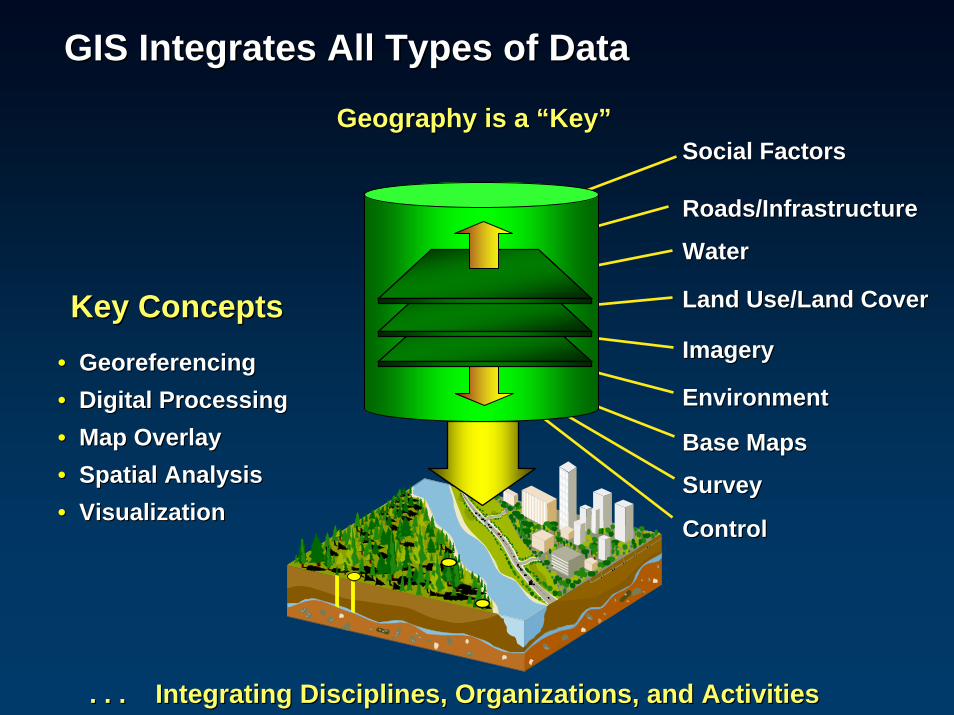
Social FactorsSocial Factors
Roads/InfrastructureRoads/Infrastructure
WaterWater
Land Use/Land CoverLand Use/Land Cover
EnvironmentEnvironment
ImageryImagery•• GeoreferencingGeoreferencing•• Digital ProcessingDigital Processing•• Map OverlayMap Overlay•• Spatial AnalysisSpatial Analysis•• VisualizationVisualization
Key ConceptsKey Concepts
GIS Integrates All Types of DataGIS Integrates All Types of Data
. . . Integrating Disciplines, Organizations, and Activities. . . Integrating Disciplines, Organizations, and Activities
Base MapsBase Maps
Geography is a Geography is a ““KeyKey””
SurveySurvey
ControlControl

GIS is an Information TechnologyGIS is an Information TechnologyThree partsThree parts
Geospatial Geospatial DataData
Geoprocessing Geoprocessing and Analytical and Analytical
ToolsTools
Applications Applications ((““ViewsViews””))
Based on geography Based on geography –– the science of our worldthe science of our world

A city of 1,000,000 spendsA city of 1,000,000 spends$50 to $100M per year$50 to $100M per year
Community investment in maintaining, applying, Community investment in maintaining, applying, and managing Geographic Informationand managing Geographic Information
A key assetA key asset
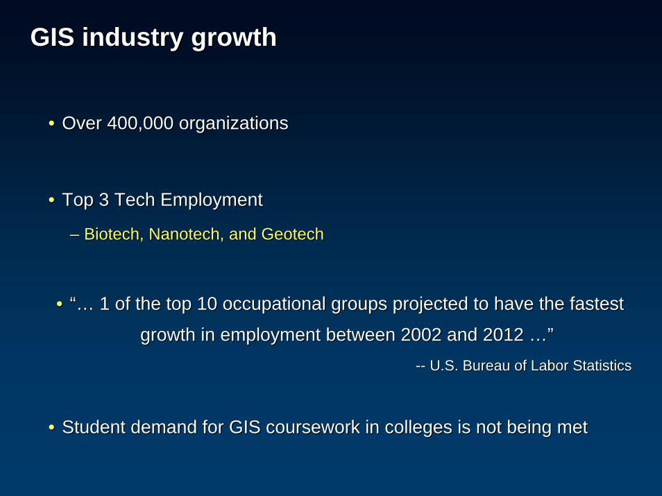
GIS industry growthGIS industry growth
•• Over 400,000 organizations Over 400,000 organizations
•• Top 3 Tech EmploymentTop 3 Tech Employment
–– Biotech, Nanotech, and GeotechBiotech, Nanotech, and Geotech
•• “…“… 1 of the top 10 occupational groups projected to have the faste1 of the top 10 occupational groups projected to have the fastest st
growth in employment between 2002 and 2012 growth in employment between 2002 and 2012 …”…”---- U.S. Bureau of Labor StatisticsU.S. Bureau of Labor Statistics
•• Student demand for GIS coursework in colleges is not being met Student demand for GIS coursework in colleges is not being met

GIS is becoming a Kind of Sensor NetworkGIS is becoming a Kind of Sensor NetworkPervasivePervasive Mobile and Wireless TechnologyMobile and Wireless Technology
•• TrafficTraffic•• WeatherWeather•• MonitorsMonitors•• SatellitesSatellites•• AircraftAircraft•• MobileMobile•• CensusCensus•• DemographicDemographic•• BusinessBusiness•• InfrastructureInfrastructure•• SurveyingSurveying•• DesignDesign
““A Digital Nervous SystemA Digital Nervous System”” ---- Jack DangermondJack Dangermond
Integrated with ServicesIntegrated with Services
GISGISServerServer
•• StreamsStreams•• SeismicSeismic•• TsunamiTsunami•• CrimeCrime•• Disease SurveillanceDisease Surveillance•• RFIDRFID•• Etc.Etc.

Mobile GISMobile GIS
•• Full MapsFull Maps
–– Tablet PCTablet PC
•• Professional GPSProfessional GPS
–– Windows CE / Pocket PCWindows CE / Pocket PC
•• Smart PhonesSmart Phones
•• Smart ClientsSmart Clients
•• Survey Total StationsSurvey Total Stations

Scalable Hardware is becoming Networked . . .Scalable Hardware is becoming Networked . . .. . . And Information is being Synchronized. . . And Information is being Synchronized
. . . and Services . . . and Services OrientedOriented
WebServices
Cell PhoneCell PhonePDAPDA
TabletTabletPCPC
LaptopLaptop
DesktopDesktop
ServerServer
Server Server ClusterCluster
BladeBladeServerServer
•• Orchestrated computingOrchestrated computing
•• Network of serversNetwork of servers
•• Connected on the webConnected on the web

GIS ServerGIS Server
DesktopDesktop
Data, Maps, Data, Maps, Images, Globes, Images, Globes,
Models, Models, Automations, Automations,
Interpretations, Interpretations, MetadataMetadata
Geographic KnowledgeGeographic Knowledge
MobileMobile
WebWeb
ExplorerExplorer
DesktopDesktopAuthorAuthor
ServeServe
UseUse
Custom Custom (Engine)(Engine)
ProfessionalsProfessionals
General usersGeneral users

PresentationPresentation(Multiple viewers)(Multiple viewers)
Globe Globe ServicesServices
Map &Map &ChartChart
ServicesServices
ImageImage--ProcessingProcessing
ServicesServices
Open Open Web Web
ServicesServices
TrackingTracking& RSS & RSS
ServicesServices
Serving/Serving/PublishingPublishing
AuthoringAuthoring
22--D D ViewersViewers
33--DDViewersViewers
Catalog Catalog ServicesServices
GeoGeo--ProcessingProcessing
ServicesServices
Enterprise Service Bus
COPCOP
Services Oriented ArchitectureServices Oriented Architecture——Enabling the GeoWebEnabling the GeoWeb

““GIS Data CentersGIS Data Centers”” . . . . . .
… Collaborative data building
. . . Providing . . . Providing Integration, Collaboration, Integration, Collaboration, and Data Compilationand Data Compilation
NationalNational
StatesStates StatesStates StatesStates
LocalsLocals LocalsLocals LocalsLocals LocalsLocals

GIS Trends GIS Trends –– Locational accuracy is increasingLocational accuracy is increasingMoving to more accurate GIS contentMoving to more accurate GIS content
•• Resolution and accuracy is increasingResolution and accuracy is increasing
•• New sensors are getting betterNew sensors are getting better
•• High resolution imagery, LIDAR, Geoprocessing, SurveyingHigh resolution imagery, LIDAR, Geoprocessing, Surveying
•• GPS accuracy is increasing and becoming ubiquitousGPS accuracy is increasing and becoming ubiquitous
•• Richer, moreRicher, more--detailed contentdetailed content
•• Increasing collection frequencyIncreasing collection frequency

ArcGIS 9.2 provides a ArcGIS 9.2 provides a highhigh--precision frameworkprecision framework for data for data integration and managementintegration and management
•• High precision geodatabaseHigh precision geodatabase
•• Cadastral workflowsCadastral workflows
•• Raster georeferencingRaster georeferencing
•• Geoprocessing supportGeoprocessing support
•• Terrain datasetsTerrain datasets
Ability to manage largeAbility to manage large--volume, transactional databasesvolume, transactional databases

ArcGIS 9.2 Enhancements for High PrecisionArcGIS 9.2 Enhancements for High Precision
•• High coordinate precision in geodatabasesHigh coordinate precision in geodatabases
•• Accurate map projections and coordinate management for raster anAccurate map projections and coordinate management for raster and CADd CAD–– Local coordinates to global reference systemLocal coordinates to global reference system
•• New Cadastral Editor in Survey AnalystNew Cadastral Editor in Survey Analyst–– A new workflow system and methodologyA new workflow system and methodology
•• Ability to manage massive sets of measurementsAbility to manage massive sets of measurements–– LIDAR and 3D Surveys to create highLIDAR and 3D Surveys to create high--resolution Terrain Datasetsresolution Terrain Datasets
–– Image serverImage server
–– File geodatabaseFile geodatabase
•• Geoprocessing on Servers Geoprocessing on Servers –– To automate and capture business rules for geographic dataTo automate and capture business rules for geographic data–– Using rich geodatabase datasets and logicUsing rich geodatabase datasets and logic
–– Repeatable workflowsRepeatable workflows
–– Centrally managedCentrally managed

GISGIS Surveying TrendsSurveying Trends
•• GIS needs are evolving to include surveyGIS needs are evolving to include survey--aware informationaware information–– Demand for spatial accuracy is increasingDemand for spatial accuracy is increasing–– More detailed data is being collectedMore detailed data is being collected
•• GIS data is being collected at a faster rate (increasing frequenGIS data is being collected at a faster rate (increasing frequency)cy)
•• Surveying is moving to GPSSurveying is moving to GPS–– Increased feature measurementIncreased feature measurement
•• Surveying will move to a GIS frameworkSurveying will move to a GIS framework–– Survey information will be integrated into comprehensive databasSurvey information will be integrated into comprehensive databases es –– For communities, states, and nationsFor communities, states, and nations
Surveying will require a comprehensive GISSurveying will require a comprehensive GIS

Spatial data conceptsSpatial data concepts
The role of survey informationThe role of survey information

LayersLayersGIS information is a bunch of data themesGIS information is a bunch of data themes
GeoGeo--referencing means that can be integratedreferencing means that can be integrated
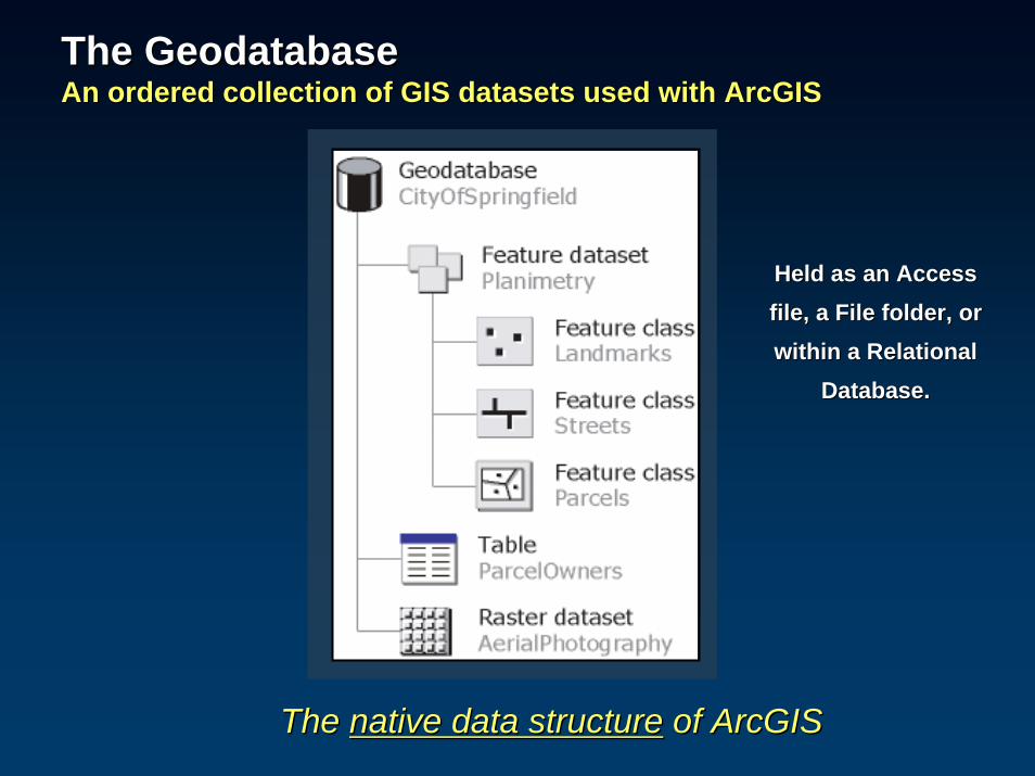
The GeodatabaseThe GeodatabaseAn ordered collection of GIS datasets used with ArcGISAn ordered collection of GIS datasets used with ArcGIS
The The native data structurenative data structure of ArcGISof ArcGIS
Held as an Access Held as an Access file, a File folder, or file, a File folder, or within a Relational within a Relational
Database.Database.

1.1. Personal Personal GeodatabaseGeodatabase
Stored in Access. 2 GB Limit, but effective size is 250 to 500 Stored in Access. 2 GB Limit, but effective size is 250 to 500 MB. Windows only. Single editor and a few readers. No MB. Windows only. Single editor and a few readers. No versioning.versioning.
2.2. File File GeodatabaseGeodatabase
Stored in file folder. Up to 1 TB per dataset. Any platform. Stored in file folder. Up to 1 TB per dataset. Any platform. Single editor and a few readers. No versioning.Single editor and a few readers. No versioning.
3.3. ArcSDEArcSDEGeodatabaseGeodatabase
Stored in RDBMS (Oracle, SQL Server, DB2, Informix). Uses Stored in RDBMS (Oracle, SQL Server, DB2, Informix). Uses ArcSDE. Versioning and MultiArcSDE. Versioning and Multi--user Support. Highly Scalable.user Support. Highly Scalable.
4.4. Geodatabase Geodatabase XMLXML
Open representation of full geodatabase schema and data as Open representation of full geodatabase schema and data as XML. Used for open data interchange with external systems.XML. Used for open data interchange with external systems.
Geodatabase StorageGeodatabase StorageOpen support for full information modelOpen support for full information model
New at 9.2New at 9.2
New at 9.2: Personal and Workgroup ArcSDENew at 9.2: Personal and Workgroup ArcSDE

Common GIS Dataset TypesCommon GIS Dataset Types
RastersRastersFeature ClassesFeature Classes
TablesTables
Simple geometry storage plus rich operatorsSimple geometry storage plus rich operators

GIS provides a framework for managing all geographic GIS provides a framework for managing all geographic informationinformationAll Spatial Data TypesAll Spatial Data Types
GeodatabaseGeodatabase
FeaturesFeaturesTopologyTopology
NetworksNetworks
TerrainTerrainAddressAddressLocatorsLocators
27 Main St.27 Main St.
AttributeAttributeTablesTables
AnnotationAnnotation
ABCABC
SurveysSurveys
107107’’
3D Objects3D Objects
RastersRasters
CadastralCadastralDatasetsDatasets
Domains, SubtypesDomains, SubtypesRelationshipsRelationships

TopologyTopologyManage spatial relationships and coincident geometriesManage spatial relationships and coincident geometries

NetworksNetworksFor managing navigation and connectivityFor managing navigation and connectivity

MultiMulti--resolution terrain dataset (TIN structure)resolution terrain dataset (TIN structure)
TerrainsTerrainsTo model surfaces using triangulated networks and manage LIDARTo model surfaces using triangulated networks and manage LIDAR
PointsPoints BreaklinesBreaklines

The Geodatabase provides a framework for The Geodatabase provides a framework for managing geospatial informationmanaging geospatial information
A high precision geodata management A high precision geodata management framework for all spatial data typesframework for all spatial data types

Vision: Survey and GPS will provide the framework for Vision: Survey and GPS will provide the framework for high precision information managementhigh precision information management

Most GIS layers register to Parcels, Transportation, and Most GIS layers register to Parcels, Transportation, and the Orthophoto Basethe Orthophoto Base

Cadastre, Roads, OrthophotoCadastre, Roads, OrthophotoAdditional data layers register onto these themesAdditional data layers register onto these themes
GIS provides the tools and workflows for integrating other GIS provides the tools and workflows for integrating other GIS layersGIS layers
OrthophotoOrthophoto
ParcelsParcels RoadsRoads
Water Water
LandcoverLandcover
TerrainTerrain
PhotogrammetryPhotogrammetry

Cadastre, Roads, OrthophotoCadastre, Roads, OrthophotoThree primary GIS base layersThree primary GIS base layers
A framework onto which other GIS layers are integratedA framework onto which other GIS layers are integrated
OrthophotoOrthophoto TransportationTransportation
Subdiv 1Subdiv 1 Subdiv 2Subdiv 2
Survey 1Survey 1 Survey 2Survey 2
ParcelsParcels
Prj 1Prj 1 Prj 2Prj 2
Survey ASurvey A Survey BSurvey BEtc. Etc.Etc. Etc.

Survey is the primary element in the high Survey is the primary element in the high precision framework for geographic dataprecision framework for geographic data
Survey information and control will become an integral part Survey information and control will become an integral part of the geodatabaseof the geodatabase
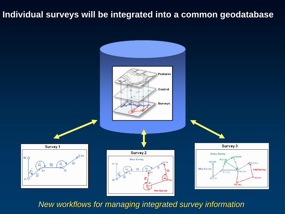
Individual surveys will be integrated into a common geodatabaseIndividual surveys will be integrated into a common geodatabase
New workflows for managing integrated survey informationNew workflows for managing integrated survey information

GIS Trends GIS Trends –– Enterprise spatial data managementEnterprise spatial data managementOpen integration of external information into intelligent geodatOpen integration of external information into intelligent geodatabaseabase
Geoprocessing Geoprocessing
Processing Processing ChainChain
Data Data InteroperabilityInteroperability
External External SourcesSources GeodatabaseGeodatabase
External data sourcesExternal data sources
Editing
Data managementData management
ETLETLIntegration and Integration and
AggregationAggregation
Data aggregation Data aggregation ---- Automated Automated scripts to apply geodatabase scripts to apply geodatabase business rules and logicbusiness rules and logic
Geoprocessing Geoprocessing
Geodatabase business Geodatabase business rules and logicrules and logic
Open Spatial Data Open Spatial Data Management Management
ServerServer

GIS Trends GIS Trends –– Enterprise spatial data managementEnterprise spatial data managementArcGISArcGIS server provides information management and publishingserver provides information management and publishing
Geoprocessing Geoprocessing
Processing Processing ChainChain
Data Data InteroperabilityInteroperability
External External SourcesSources ArcSDEArcSDE
GeodatabaseGeodatabase
External data sourcesExternal data sources
Synchronization Synchronization
DepartmentsDepartments
EnterpriseEnterprise
RegionsRegions
Editing
Data Data managementmanagement
Distributed replicasDistributed replicas
ArcGIS ServerArcGIS Server
PublishingPublishingMapsMaps GlobesGlobes ModelsModels DataData
ETLETLIntegration and Integration and
AggregationAggregation

GIS UtopiaGIS Utopia
WhatWhat’’s possible five years from now?s possible five years from now?

GIS UtopiaGIS Utopia
•• ““ItIt’’s all GISs all GIS””–– ImageryImagery
–– SurveyingSurveying
–– WeatherWeather
–– Design & constructionDesign & construction
–– GPSGPS
–– RFIDRFID
–– Google Earth, Microsoft, Open Source, CommercialGoogle Earth, Microsoft, Open Source, Commercial

GIS UtopiaGIS Utopia
•• A network of GISA network of GIS’’s becomes the Digital Nervous System s becomes the Digital Nervous System
for the Planetfor the Planet
–– Integrates the sensor networks (weather, disease, surveillance,Integrates the sensor networks (weather, disease, surveillance, traffic, traffic,
utilities, GPS, RFID, survey, gauges, observations)utilities, GPS, RFID, survey, gauges, observations)
–– Data flows to where itData flows to where it’’s needed and is automatically transformed into the s needed and is automatically transformed into the
required formatsrequired formats
–– Survey control provides the Survey control provides the farmeworkfarmework

GIS UtopiaGIS Utopia
•• National Geodetic Survey and the National Cadastre are National Geodetic Survey and the National Cadastre are
openly available as web servicesopenly available as web services
–– Getting there (NGS and BLM NILS)Getting there (NGS and BLM NILS)
•• State and Local Systems are part of this networkState and Local Systems are part of this network–– Integrates local and contract surveyorsIntegrates local and contract surveyors
–– Local survey projects are integrated in a series of common geoLocal survey projects are integrated in a series of common geo--databasesdatabases

•• GIS software will be bug free and just workGIS software will be bug free and just work
GIS UtopiaGIS Utopia
•• Construction Life Cycle / Infrastructure will be based on GIS Construction Life Cycle / Infrastructure will be based on GIS
–– PlanningPlanning
–– SurveyingSurveying
–– DesignDesign
–– PermittingPermitting
–– ConstructionConstruction
–– InspectionInspection
–– Management and maintenanceManagement and maintenance
GIS UtopiaGIS Utopia
•• The Public will be able to access high quality public data The Public will be able to access high quality public data
with high levels of accuracy, detail, and precisionwith high levels of accuracy, detail, and precision
–– High qualityHigh quality
–– UpUp--toto--the minutethe minute
–– High accuracyHigh accuracy
–– Very large scale (>1:500)Very large scale (>1:500)
–– Multiple Levels of DetailMultiple Levels of Detail
GIS UtopiaGIS Utopia
Government stewardship will be requiredGovernment stewardship will be required

Thank youThank you
Top Related