


Languages
Pages
Legal


DRAFT PLAN OF MANAGEMENT FOR CROWN RESERVES PARK AND NATURAL AREAS
October 2021
PREPARED FOR
HUNTER’S HILL COUNCIL
BY
CGM PLANNING & ENVIRONMENTAL PARTNERSHIP NSW WITH ECONPLAN

Issue Date Description By
1 22/01/21 Preliminary Draft CGM
2 2/03/21 Final Draft for Council and Crown Land review
CGM
3 28/10/21 Final Draft for public exhibition HHC

ACKNOWLEDGEMENT OF COUNTRY
Hunter's Hill Council acknowledges and honours
the Wallamedegal people of the Eora Nation as
the traditional custodians of this land.
Hunter’s Hill Council pays respect to the Elders
past, present and emerging, and honours
Australian Aboriginal and Torres Strait Islander
peoples’ unique cultural and spiritual
relationships to place and society.
2
CONTENTS
ACKNOWLEDGEMENT OF COUNTRY 3
PART 1 5
INTRODUCTION AND GENERAL INFORMATION 5
1.1 What is the plan of management 6
1.2 Scope of the plan of management 7
1.3 Hunter’s Hill 7
2.1 Corporate objectives 9
2.2 Land to which this plan applies 13
2.2.1 What land is covered by this plan of management? 13
2.2.2 Land use zoning 13
2.2.3 Owner of the land 14
2.2.4 About this plan of management 14
2.2.5 Categorises for community land 15
3 RELEVANT LEGISLATION, POLICIES AND PROCEDURES 17
3.1 Legislative framework 17
3.1.1 Crown Land Management Act 2016 17
3.1.2 Local Government Act 1993 19
3.1.3 Native Title Act 1993 20
3.2 Other state and federal legislation 20
3.2.1 NSW state legislation 20
3.2.2 Commonwealth legislation 23
3.2.3 State Environmental Planning Policies 23
3.2.4 Strategic regional plans and actions 24
3.2.5 Other relevant legislation, policies and plans 27
3.3 Council plans and policies relating to this plan of management 28
3.4 Purpose of the plan of management 28
3.5 Review of plan of management 28
3.6 Community Consultation 28
3.6.1 Public Exhibition 30
4 HERITAGE AND CULTURAL SIGNIFICANCE 31
4.1 Aboriginal Cultural Heritage 31
4.2 Post 1788 Cultural Heritage 31
5 POM ADMINISTRATION AND MANAGEMENT 32
5.1 Reporting, evaluation and review 32
PART 2 33
DETAILED MANAGEMENT REQUIREMENTS FOR COMMUNITY LAND CATEGORIES 33

3
6 PARK 34
6.1 Introduction 34
6.1.1 Reserves with a Park category 35
6.2 Key management issues 45
6.3 Management framework for areas categorised as Park 51
6.4 Permitted development and use 59
6.5 Express authorisation of leases and licenses and other estates 60
6.6 Leases and licenses authorised by this plan of management 60
6.7 Short-term licences 60
7 NATURAL AREAS 63
7.1 Introduction 63
7.1.1 Core objectives 63
7.1.2 Physical environment of reserves with Natural Area category 64
7.1.3 Development and use 70
7.1.4 Express authorisation of leases, licences and other estates 70
NATURAL AREA BUSHLAND 72
7.2 Introduction 72
7.3 Key management issues 73
7.4 Management framework for areas categorised as Natural Area - Bushland 76
7.5 Permitted development and use 84
NATURAL AREA FORESHORE 85
7.6 Introduction 85
7.7 Key management issues 86
7.8 Management framework for areas categorised as Natural Area - Foreshore 88
7.9 Permitted development and use 92
APPENDICES 94

5
PART 1 INTRODUCTION AND GENERAL INFORMATION

6
1. KEY INFORMATION
1.1 What is the plan of management
The Local Government Act 1993 (NSW) (LG Act) requires a plan of management to be
prepared for all public land that is classified as ‘community’ land under the LG Act.
A plan of management (PoM) outlines community land and it features, and clarifies how
Council shall manage, use or develop this land into the future. It identifies Council’s goals and
objectives for the land and establishes the overall direction for planning, resource
management and maintenance.
A PoM is an important management tool written by Council in consultation with the community,
providing a transparent and coordinated approach to public land management.
Under section 36(3) of the LG Act a PoM must:
• categorise the land in accordance with the legislation;
• contain objectives and performance targets for the management of the land;
• specify the means by which Council proposes to achieve the plan’s objectives and
performance targets; and
• identify how Council intends to assess its performance of the objectives and
performance targets.
Under section 36(3A) of the LG Act a PoM must also:
• describe the condition of the land, any buildings or other improvements on the land as
at the adoption of the plan;
• describe the use of the land and other building and improvements as at that date;
• state the purposes for which the land, and any such buildings or improvements will be
permitted to be used;
• specify why any further development of the land will be allowed, whether under license
or lease or other; and
• describe the scale and intensity of any such permitted use or development.
If there are any additional development proposals of the community land other than that
authorised by this PoM, including a proposed change in a categorisation of an area,
amendment and re-exhibition of the PoM is required.
A PoM can be prepared for more than one parcel of land (generic or geographic) or for a
single property (significant or specific). This is a generic plan for community land which
covers multiple reserves.

7
1.2 Scope of the plan of management
This PoM has been prepared for Hunter’s Hill Council for 10 Crown reserves within the Local
Government Area (LGA). These are listed below by reserve number and name:
• 37233 Mornington Reserve
• 47916 Murray Prior Reserve
• 500284 Collingwood St Reserve
• 500286 Woolwich Baths and Boatshed
• 500262 St Johns Park (Part Boronia Park)
• 1000442 Wharf Reserve (Next to Kelly’s Bush)
• 87323 Villa Maria Reserve
• 1000434 Valentia Street Reserve (2 Parts)
• 92875 Valencia Street Reserve (Part: Wharf) adjoins R1000434
• 1000435 Gale Street Reserve (Verge)
It was referred to the Minister administering the Crown Land Management Act 2016, as
representative of the landowner (the State of NSW), on 18 March 2021 to enable public
exhibition. Following public exhibition and consideration of submissions the PoM will be
referred to the Minister prior to being adopted by Council. [Include date of adoption once
finalised]
1.3 Hunter’s Hill
Hunter’s Hill is located 7 kilometres from the Sydney GPO and covers approximately 550
hectares with 19 kms of river frontage. It is the smallest local government area in Sydney
covering an area of 6 sq km. The Hunter’s Hill peninsula is within Sydney Harbour and is
bounded by the Lane Cove and Parramatta Rivers, extending west to Pittwater Road,
Gladesville.
Hunter’s Hill Council includes the suburbs of Gladesville (part), Henley, Hunter’s Hill, Huntley’s
Cove, Huntley’s Point and Woolwich. The municipality is predominantly residential, including
numerous parks and reserves with very little commercial land use. Hunter’s Hill is recognized
as Australia’s oldest garden suburb.
The original inhabitants of the Hunter’s Hill area are the Wallumedegal. European settlement
dates from 1795 when land was first farmed. The area has a certain French feel, with many of
the early houses designed by the French brothers, Didier and Jules Joubert. The Joubert
brothers used local Italian stonemasons and sandstone creating the most distinguishing
feature of Hunter’s Hill - its buildings, structures and gardens. These unique characteristics
led a majority of the Municipality to be recognised as a Conservation Area.
Today, Hunter’s Hill is mainly comprised of low scale residential land uses that reflect key
housing development periods in Sydney’s expansion. It is comprised of recreational and open
spaces land that forms leafy garden, bushland and foreshore setting of the inner suburban
LGA. There are some limited commercial, foreshore and industrial land uses in the area.

8
Hunter’s Hill’s current Estimate Resident Population is 14,980 (2019)1. The most recent
Census, 2016 has Hunter’s Hill population at 13,999 where of all households, 73.7% were
families: families with children (1,838, 53.2%), couples without children (1,201, 34.8%) and
lone person households (1,110, 24.2%)2. An increase in single households is predicted as the
population ages, a characteristic of the Australian population. The LGA is well known for its
schools, accessible location, open spaces and community spirit.
1 Australian Bureau of Statistics: Hunter’s Hill (A) : Region Data Summary (abs.gov.au) 2 Australian Bureau of Statistics: 2016 Census QuickStats: Hunter’s Hill (A) (abs.gov.au)

9
2 INTRODUCTION
2.1 Corporate objectives
Community Strategic Plan – Your Vision for our Future 2018 – 2028
The Hunter’s Hill Community Strategic Plan (CSP) is a 10 year plan that identifies the
community’s priorities and aspirations for the future, as well as the challenges in working
towards long term sustainability.
Delivery of the CSP is underpinned by its vision: To protect and enhance the integrity,
character and visual amenity of the Hunter’s Hill Local Government Area through leadership,
community involvement and the pursuit of excellence.
The CSP provides a snapshot of the Hunter’s Hill community, including population projections
and community feedback. Five key directions were identified by the Plan - the following being
the most applicable for the reserves in this PoM.
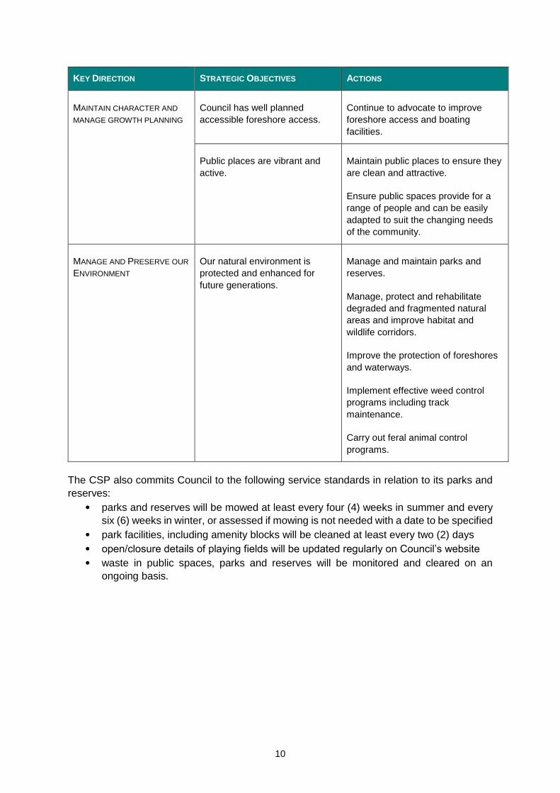
Table 2.1 Key directions identified in the CSP most applicable to this PoM
KEY DIRECTION STRATEGIC OBJECTIVES ACTIONS
FOCUS ON THE COMMUNITY Plans of management reflect
community need.
New plans of management are
prepared.
Council encourages a sense of
belonging and connection to the
local community.
Support and facilitate initiatives and
projects to promote local community
groups.
Council provides accessible
services and facilities to
residents of all abilities.
Implement the Disability Inclusion
Action Plan (DIAP).
Review the use of open spaces,
parks, reserves, playgrounds in line
with DIAP, PoMs and Council’s Asset
Management Plans.
Universal Design Principles are
incorporate into plans and
documents.
Maximise access to and usage of
Council’s community and sporting
facilities.
Services and facilities that are
child, youth, family and age
friendly are supported.
Improve and maximise access to and
use of parks, community, sporting
and cultural facilities.
10
KEY DIRECTION STRATEGIC OBJECTIVES ACTIONS
MAINTAIN CHARACTER AND
MANAGE GROWTH PLANNING
Council has well planned
accessible foreshore access.
Continue to advocate to improve
foreshore access and boating
facilities.
Public places are vibrant and
active.
Maintain public places to ensure they
are clean and attractive.
Ensure public spaces provide for a
range of people and can be easily
adapted to suit the changing needs
of the community.
MANAGE AND PRESERVE OUR
ENVIRONMENT
Our natural environment is
protected and enhanced for
future generations.
Manage and maintain parks and
reserves.
Manage, protect and rehabilitate
degraded and fragmented natural
areas and improve habitat and
wildlife corridors.
Improve the protection of foreshores
and waterways.
Implement effective weed control
programs including track
maintenance.
Carry out feral animal control
programs.
The CSP also commits Council to the following service standards in relation to its parks and
reserves:
• parks and reserves will be mowed at least every four (4) weeks in summer and every
six (6) weeks in winter, or assessed if mowing is not needed with a date to be specified
• park facilities, including amenity blocks will be cleaned at least every two (2) days
• open/closure details of playing fields will be updated regularly on Council’s website
• waste in public spaces, parks and reserves will be monitored and cleared on an
ongoing basis.

11
Hunter’s Hill Local Strategic Planning Statement
The Hunter’s Hill Local Strategic Planning Statement (LSPS) was adopted by Council in April
2020 and outlines a 20-year vision for land use in the LGA. It sets the framework for how the
Greater Sydney Regional Plan and the North District Plan’s directions are to be implemented
locally and is a requirement under the Environmental Planning & Assessment Act 1979 (EP&A
Act)
The LSPS considers economic, social and environmental matters along with housing, place
making and land supply needs for new and renewal lands. It includes planning priorities and
actions, an implementation program, and a structure plan, which visually shows key directions
and principles for the LGA over the next 20 years.
The LSPS covers public and private lands and operates alongside the Community Strategic
Plan. This PoM may contribute to the attainment of the following LSPS sustainability action to:
8. Maintain and enhance the natural and built heritage character of Hunter’s Hill:
8.5. Investigate opportunities for improved stormwater management and work with the
Parramatta River Catchment Group to improve the health and sustainability of the river
catchment.
8.6. Develop and implement strategies to improve the public domain in line with sustainable
practices and community expectations e.g: LED street light program for energy
efficiency, e-car technology, biodiversity.
8.7. Expand the urban tree canopy in the public domain to support the Greater Sydney
Green Grid. Explore and expand the provision of trees on private lands at the
development stage to support the Greater Sydney Green Grid.
Draft Property Strategy (previously Community Infrastructure Plan 2020)
The Council’s draft Property Strategy was exhibited from 18 September to 9 November 2020.
The draft Strategy outlined a direction towards a sustainable future for the provision of
community facilities to address community need now and into the future.
It outlined the following community and social outcomes:
• Innovative services and assets that meet current and future community needs
• Property being used as a means of getting services to users (rather than solely for
ownership purposes)
• A sustainable built environment that accommodates a growing population
• Places, spaces and support for the wellbeing of the community
• Well-used community and civic facilities.
These outcomes were supported by the following goals:
• Improved Community Service delivery
• A place-based approach to deliver facilities, services, programs and initiatives
• Quality cultural facilities/spaces including a new library, art spaces and live
performance
• Quality recreational spaces both internal and external
• Quality open space
• Appropriate facilities for organisational requirements integrating to other community
facilities.

12
As with many NSW councils the challenge for Council is to raise sufficient funding to deliver
improved facilities to serve the community. This PoM acknowledges the constraints when
servicing parks and reserves to provide quality open space, including public places that are
accessible and support community wellbeing. Council does this by seeking funding
opportunities, responding to volunteerism and community groups, as well as setting priorities.
Crown Land 2031 - State Strategic Plan for Crown Land
The State Strategic Plan for Crown Land takes into account environmental, social, cultural
heritage and economic considerations for the management of Crown land.
The vision embodied in this plan is for: Crown land supports resilient, sustainable and
prosperous communities across NSW.
The priorities identified for Crown land over the next 10 years are to:
• strengthen community connections with Crown lands
• accelerate economic progress in regional and rural NSW
• accelerate the realisation of Aboriginal land rights and native title in partnership with
Aboriginal people
• protect cultural heritage on Crown land
• protect environmental assets, improve and expand green space and build climate
change resilience.
.
These priorities are supported by a set of outcomes to be achieved over the early, middle and
full decade of the plan..

13
2.2 Land to which this plan applies
2.2.1 What land is covered by this plan of management?
The land covered by this plan of management is identified in the schedule in Appendix A.
There are 10 Crown reserves managed as community land by Council as Crown land manager
under this PoM. The land is defined by real property identifiers (lots and deposited plans), as
well as shown by maps in Appendix B.
The land on these reserves has been categorised as one or more of the following:
• Park
• Natural Area – Bushland
• Natural Area – Foreshore.
Each of these categories have specific core objectives under the Local Government Act 1993
which dictates what can happen on the land. These are detailed under the relevant
section/chapter of this document.
2.2.2 Land use zoning
The reserves within this PoM are zoned under the Hunters Hill LEP 2012 (LEP) as either E2
Environment Conservation or RE1 Public Recreation as shown in Table 2.2.
Table 2.2 Reserve Purposes and Land Use Zone
RESERVE
NO.
RESERVE NAME RP IDENTIFIER
(LOTS/DP)
CROWN LAND
PURPOSE
CATEGORY HUNTER’S
HILL LEP
2012
37233 Mornington
Reserve
Lot 7341
DP 1155948
Access; Public
Recreation
Park
Natural Area
Bushland
Natural Area
Foreshore
E2
47916 Murray Prior
Reserve
Lot 7343
DP 1155920
Public Baths;
Recreation
Park
Natural Area
Bushland
Natural Area
Foreshore
E2
500284 Collingwood St
Reserve
Lot 7339
DP 1162761
Baths;
Boatshed
Park
Natural Area
Foreshore
RE1
500286 Woolwich Baths
and Boatshed
Lot 7340
DP 1162761
Boatshed;
Public Baths
Park
RE1
500262
(PART)
St Johns Park
(Part Boronia
Park)
Lot 829
DP 752035
Part Lot 7352
DP 1156319
Public
Recreation
Natural Area
Bushland
E2
1000442 Wharf Reserve
[Next to Kelly’s
Bush]
Lot 1
DP 1154490
Public Wharf Natural Area
Bushland
E2

14
RESERVE
NO.
RESERVE NAME RP IDENTIFIER
(LOTS/DP)
CROWN LAND
PURPOSE
CATEGORY HUNTER’S
HILL LEP
2012
87323 Villa Maria
Reserve
Lot 1
DP 909044
Public
Recreation
Park RE1
1000434 Valentia Street
Reserve [2
Parts]
Lot 1
DP 725593
Wharfage Park RE1
92875 Valencia Street
Reserve (Part:
Wharf)
Adjoins
R1000434
Lot 2
DP 909048
Wharf Site Park RE1
1000435 Gale Street
Reserve [Verge]
Lot 1
DP 1153661
Public Wharf Park RE1
The objectives of these zones and the permissible uses can be found within the LEP and
should be referenced to ensure that development is consistent not only with this PoM but also
the LEP.
2.2.3 Owner of the land
The subject land is owned by the State of NSW (Crown land).
Refer to 3.1.1 Crown land management compliance for any conditions applying to the land.
2.2.4 About this plan of management
The LG Act requires community land to be managed and used in accordance with an adopted
PoM.
This PoM is a generic document covering the community land and open space within the
Hunter’s Hill LGA categorised as Park and Natural area. Natural area community land is
further categorised into bushland and foreshore.
This draft PoM applies to Crown reserves where Hunter’s Hill Council was appointed Crown
land manager in 2018 on the commencement of the CLM Act. See 3.1.1 for primary legislation
that affects how community land is managed, and further explanation of the Crown Land
Management Act 2016.
A single cohesive plan enables consistent management of the open space network and
enhanced appreciation by the wider community of its benefits, variety and distribution.

15
2.2.5 Categorises for community land
Section 36(4) of the LG Act defines five categories of community land:
• Natural area: for all areas that play an important role in the area’s ecology. This
category is further subdivided into bushland, escarpment, foreshore, watercourse and
wetland categories.
• Sportsground: for areas where the primary use is for active recreation involving
organised sports or the playing of outdoor games.
• Park: for areas primarily used for passive recreation.
• Cultural significance: for areas with Aboriginal, aesthetic, archaeological, historical,
technical, research or social significance.
• General community use: for all areas where the primary purpose relates to public
recreation and the physical, cultural, social, and intellectual welfare or development of
members of the public. This includes venues such as community halls, scout and guide
halls, and libraries.
All community land must be assigned to one or more LG Act community land ‘categories’
wh i c h define how Council will manage each parcel of land. Each category has set
guidelines for assigning categories and core objectives providing guidance to the
management of community land. The core objectives for each category give a broad
strategic direction for management of this land, which is the same for all community land of
the same category across NSW.
The CLM Act requires that assignment of community land categorisations to Crown reserves
have close regard for the Crown reserve’s purpose. The reserve purposes for the 10 reserves
within this PoM are listed in Table 2.2.
Table 2.3 Community land categorisation summary
RESERVE NUMBER
LAND PARCEL
INITIAL ASSIGNED AND DIRECTED
CATEGORY
PROPOSED CATEGORY UNDER
THIS DRAFT POM
Mornington Reserve
No 37233
Lot 7341 DP 1155948
Natural Area (directed broad
category but not specific)
Park,
Natural Area – Bushland
Natural Area - Foreshore Murray Prior Reserve
No 47916
Lot 7343 DP 1155920
Park Park,
Natural Area – Bushland,
Natural Area – Foreshore Collingwood Street Reserve
No 500284
Lot 7339 DP 1162761
Park and General Community
Use
Park,
Natural Area - Foreshore
Woolwich Baths and
Boatsheds Reserve
No 500286
Lot 7340 DP 1162761
Park (directed) Park
St Johns Park (part Boronia
Park) Reserve No 500262
(Part)
Lot 829 DP 752035
Part Lot 7352 DP 1156319
Park Natural Area - Bushland

16
RESERVE NUMBER
LAND PARCEL
INITIAL ASSIGNED AND DIRECTED
CATEGORY
PROPOSED CATEGORY UNDER
THIS DRAFT POM
Wharf Reserve (Next to Kelly’s
Bush)
No 1000442
Lot 1 DP 1154490
Natural Area Bushland
(directed)
Natural Area - Bushland
Villa Maria Reserve
No 87323
Lot 1 DP 909044
Park Park
Valentia Street Reserve
No 1000434
Lot 1 DP 725593
Park (directed) Park
Valencia Street Reserve (Part
Wharf) Reserve
No 92875
Lot 2 DP 909048
General Community Use Park
Gale Street Reserve
No 1000435
Lot 1 DP 1153661
General Community Use Park
17
3 RELEVANT LEGISLATION, POLICIES AND
PROCEDURES
3.1 Legislative framework
The primary legislation that affects how community land is managed or used is briefly
described below. You can find more information about these Acts at
www.legislation.nsw.gov.au
3.1.1 Crown Land Management Act 2016
Crown land is governed by the CLM Act, which provides a framework for the state government,
local councils, and members of the community to work together to provide care, control and
management of Crown reserves.
Crown reserves are Crown land set aside on behalf of the community for a wide range of
purposes, including environmental and heritage protection, recreation and sport, open space,
community halls, special events and government services.
Many Crown reserves in NSW were previously managed by councils on behalf of the NSW
Government under a trust structure. The CLM Act 2016 abolished these reserve trusts and
reserve trust managers and provided for the appointment of local Councils (and others) as
‘Crown land managers’ with regard to the land previously held by reserve trusts. Irrespective
of these changes, land must still be managed in accordance with the purpose of the land and
cannot be used for an activity incompatible with its purpose, e.g: Crown land assigned the
purpose of ‘environmental protection’ cannot be used in a way that compromises its
environmental integrity.
Additionally, Councils must manage Crown land in accordance with the principles of Crown
land management outlined in the CLM Act. The principles are the key values that guide Crown
land management to benefit the community, and to ensure that Crown land is managed for
sustainable, multiple uses.
Principles of Crown land management
• Environmental protection principles are to be observed in the management and
administration of Crown land.
• The natural resources of Crown land (including water, soil, flora, fauna and scenic
quality) will be conserved wherever possible.
• Public use and enjoyment of appropriate Crown land are to be encouraged.
• Where appropriate, multiple uses of Crown land should be encouraged.
• Where appropriate, Crown land should be used and managed in such a way that both
the land and its resources are sustained.
• Crown land is to be occupied, used, sold, leased, licensed or otherwise dealt with in
the best interests of the state of NSW, consistent with the above principles.

18
Crown land management compliance
Management of Crown reserves shall be in alignment with the reserve purposes, and generally
there are additional elements that may influence how Council shall manage Crown reserve.
Examples of this include conditional attachments to appointment instruments, or compliance
requirements with specific or general rules published in NSW Government Gazette. Councils
must also comply with any Crown land regulations that are made.
There are no conditions attached to any Crown land manager appointment notice for Council,
and only one Crown land management rule applies to Hunter’s Hill LGA.
This gazetted rule has been made under s.3.15 of the CLM Act and can be viewed in full at:
Granting leases and licences for communication infrastructure-related purposes on Crown
land
The rule.
Crown land managers cannot, under any act (including the Local Government Act
1993), grant any lease or licence authorising:
the installation or construction of communication infrastructure on Crown
land
the placement of communication infrastructure on Crown land
the use of communication infrastructure that is located on Crown land
access to communication infrastructure that is located on Crown land.
However, the rule does not prevent the holder of a holding granted by the Minister
administering the Crown Land Management Act 2016 subletting of communication
infrastructure located on Crown land in accordance with the conditions of a holding
granted by the minister.
Reserve Purpose
Crown lands are to be used for the original gazetted purpose for which they were dedicated
or reserved. Multiple uses of reserves are encouraged, where those uses are consistent with
the original purpose of the reserve and the use does not impact on native title rights and
interests under the Native Title Act 1993. See Appendix A for a list of the reserves and their
purpose covered by this generic PoM.
Leasing and Licencing on Crown Reserves
Leasing and licensing of Crown land ensures there is legal and suitable occupation of Crown
land. Under the CLM Act, a lease or licence is a type of tenure that gives permission to occupy
and use Crown land for a specified purpose and term. The CLM Act enables Council Crown
land managers to enter leases and licences in accordance with the LG Act. This may occur
once a compliant plan of management is in place or the land is classified as operational,
whichever occurs first.
Council cannot enter into agreements for use, as lessor or licensor, on devolved reserves,
which are not community or public land under the LG Act. These reserves are managed by
Council under the LG Act as section 48 ‘public reserves’ and a PoM is not required for these
reserves.

19
The Council Crown land manager is required to ensure all income received from the use of
community land is directed to maintaining and sustaining long-term use and enjoyment of the
reserve(s). The income generated from leasing and licencing is a primary form of funding for
a Crown land manager. It allows a Crown land manager to cover long-term running costs (at
a minimum) and invest over the long term for future generations to use and enjoy the Crown
land in their community.
All Crown land managers should have lease and licence agreements in place with users of
the reserves that they manage. Refer to each category section of this document for leases
and licenses authorised by this PoM.
3.1.2 Local Government Act 1993
Section 35 of the LG Act provides that community land can only be used and managed in
accordance with:
• the plan of management applying to that area of community land;
• any law permitting the use of the land for a specified purpose or otherwise regulating
the use of the land; and
• the provisions of Division 2, Part 2 (public land) of Chapter 6 of the Act.
Section 36(3) of the LG Act provides that a plan of management for community land must
identify the following:
a) the category of the land;
b) the objectives and performance targets of the plan with respect to the land;
c) the means by which the council proposes to achieve the plan’s objectives and
performance targets; and
d) the manner in which the council proposes to assess its performance with respect to
the plan’s objectives and performance targets,
and may require the prior approval of the council to the carrying out of any specified
activity on the land.
Section 36(4) states that land is to be categorised as one or more of the following:
a) a natural area;
b) a sportsground;
c) a park;
d) an area of cultural significance or
e) general community use.
Section 36(5) outlines that land categorised as a natural area is to be further categorised as
one or more of the following: bushland, wetland, escarpment, watercourse, foreshore or a
category prescribed by the regulations.

20
3.1.3 Native Title Act 1993
The Commonwealth Native Title Act 1993 (NT Act) recognises and protects native title rights
and interests. The objects in Section 3 of the NT Act are:
• to provide for the recognition and protection of native title; and
• to establish ways in which future dealings affecting native title may proceed and to set
standards for those dealings; and
• to establish a mechanism for determining claims to native title; and
• provide for, or permit, the validation of past acts invalidated because of the existence
of native title.
The NT Act may affect use of Crown land, particularly development of the land and granting
of tenure. Specifically, the CLM Act makes it mandatory for council to engage or employ a
native title manager. This role provides advice to Council as to how the Council’s dealings and
activities on Crown land may be valid or not valid under the NT Act.
Generally, the Council must obtain the written advice from an accredited native title manager
as to whether council complies with any applicable provisions of the native title legislation
when:
a) granting leases, licences, permits, forestry rights, easements or rights of way over
the land
b) mortgaging the land or allowing it to be mortgaged
c) imposing, requiring or agreeing to covenants, conditions or other restrictions on use
(or removing or releasing, or agreeing to remove or release, covenants, conditions or
other restrictions on use) in connection with dealings involving the land
d) approving (or submitting for approval) a plan of management for the land that
authorises or permits any of the kinds of dealings referred to in (a), (b) or (c).
Council’s Native Title Manager has been and will continue to be consulted in all relevant
aspects of native title pertaining to the land that is covered by this PoM.
3.2 Other state and federal legislation
3.2.1 NSW state legislation
Environmental Planning and Assessment Act 1979
The Environmental Planning and Assessment Act 1979 (EP&A Act) provides the framework
for planning and development across NSW and guides environmental planning instruments
that provide a basis for development control.
The EP&A Act ensures that effects on the natural environment, along with social and economic
factors, are considered by the council when granting approval for or undertaking work,
development, or activities.
This Act is also the enabling legislation for planning policies that may have a direct influence
on open space management. On a state-wide level there are State Environmental Planning
Policies (SEPPs). On a regional level there are Regional Environmental Plans (REPs). On a
local level there are Local Environmental Plans (LEPs), as well as Development Control Plans
(DCPs).

21
Aboriginal Land Rights Act 1983
The Aboriginal Land Rights Act 1983 (ALR Act) is important legislation that recognises the
rights of Aboriginal people in NSW. It recognises the need of Aboriginal people for land and
acknowledges that land for Aboriginal people in the past was progressively reduced without
compensation. Crown land that meets certain criteria may be granted to an Aboriginal Land
Council. This Act may affect dealings with Crown land that is potentially claimable.
Biosecurity Act 2015
The NSW Biosecurity Act 2015 (NSWB Act) enables landholders, community, industry and
Government to effectively manage and respond to biosecurity incursions and risks. A
fundamental principle of the NSWB Act is that biosecurity is everyone’s responsibility, and all
land managers have the same responsibilities - a duty to prevent, eliminate or minimise risk
as far as reasonably practicable.
Council has obligations under this Act to manage Priority Weeds on Council land or Council
managed land. Under the Act, weeds are divided into State, Regional and Local Priority
Weeds (formerly referred to as Noxious Weeds). State and Regional priority weeds are
identified in the Greater Sydney Regional Weed Management Plan (September 2019) and
outcomes for these weeds needs to demonstrate compliance with the Biosecurity Duty for the
species listed in Appendix 1 of the Weed Management Plan.
Since 1 July 2018, the management of pest animals has been administered under the
Biosecurity Act 2015. Foxes/rabbits are included in the Greater Sydney Regional Strategic
Pest Animal Plan 2018-2023 and a threat abatement plan to rid them has been prepared under
the Biodiversity Conservation Act.
Coastal Management Act 2016
Coastal Management Act 2016 addresses the ecologically sustainable management, use and
development of the coastal environment and defined “coastal zone” areas.
The Act defines the coastal zone as comprising four coastal management areas. Each coastal
management area has differentiated objectives under the Act, which respond to their social
and environmental values and key threats.
Heritage Act 1977
This Act contains provisions for the conservation of items of heritage and may relate to
community land categorised as cultural significance, natural area or park.
Local heritage items and heritage conservation areas are included in the Hunter’s Hill LEP
2012 and comprise sites and areas within this PoM. State heritage items are found in the State
Heritage Register.

22
National Parks and Wildlife Act 1974
Statutory responsibilities on the council arising from this Act specifically relate to the protection
of sites of pre- and post-European contact archaeological significance and the protection of
native flora and fauna. This Act may affect community land categorised as cultural
significance, natural area, or park.
Aboriginal cultural heritage in NSW is protected by the National Parks and Wildlife Act 1974.
Under the Act it is an offence to harm (destroy, deface, or damage) or desecrate an Aboriginal
object or Aboriginal place, or move an object from the land on which is has been situated.
Biodiversity Conservation Act 2016
This Act covers conservation of threatened species, populations, and ecological communities,
and relates to community land categorised as natural area. It applies only to the terrestrial
environment.
It sets out a process for listing threatened plants and animals and establishes the “Saving our
Species” biodiversity conservation program for threatened species and threatened ecological
communities.
No endangered or threatened species have been recorded for the parks and reserves in this
PoM.
The Biodiversity Conservation Act 2016 applies to the following reserves:
• Sydney Turpentine-Ironbark Forest in St Johns Park - listed as a Critically Endangered
Ecological Community under the Act.
• A colony of Grey Headed Flying Fox (Pteropus poliocephalus), listed as vulnerable
under the Act, exists in Riverglade Reserve along Tarban Creek. These bats use the
reserves within Hunter’s Hill LGA as foraging habitat.
• Although not sighted in any reserves to date, there is potential for other endangered
or migratory species listed under the Act to be present.
Fisheries Management Act 1994
The Fisheries Management Act 1994 (FM Act) includes provisions for the management of state
fisheries, including the conservation of fish habitats, threatened species, populations and
ecological communities of fish and marine vegetation and management of the riparian zone,
waterways and threatened marine/freshwater aquatic species. This relates to community land
categorised as natural area (foreshore, watercourse, or wetland).
Rural Fires Act 1997
This Act contains provisions for bushfire risk management and the establishment of a Bushfire
Management Committee. It also includes direction on development in bushfire prone lands.
23
3.2.2 Commonwealth legislation
Environmental Protection and Biodiversity Conservation Act 1999
This Act enables the Australian Government to join with the states and territories in providing
a national scheme of environment and heritage protection and biodiversity conservation. It
incorporates threatened species on a national level and with relevance to Matters of National
Environmental Significance.
Telecommunications Act 1997
This Act provides for telecommunication facilities being permitted on community land without
authorisation in a PoM.
3.2.3 State Environmental Planning Policies
State Environmental Planning Policy No 19 – Bushland in urban areas
This planning policy deals with bushland in urban areas, so is applicable to PoMs for community
land categorised as Natural Area—Bushland.
State Environmental Planning Policy (Coastal Management) 2018
The aim of this planning policy is to promote an integrated and co-ordinated approach to land
use planning in the coastal zone in a manner consistent with the objectives of the Coastal
Management Act 2016.
State Environmental Planning Policy (Infrastructure) 2007
This planning policy lists development allowed with consent or without consent on community
land.
State Environmental Planning Policy (Vegetation in Non-Rural Areas) 2017
This policy deals with clearing of native vegetation in urban areas and land zoned for
environmental protection.
Sydney Regional Environmental Plan (Sydney Harbour Catchment) 2005 (Deemed
SEPP)
This policy provides an improved and clear planning framework and better environmental
outcomes for Sydney Harbour and its tributaries. Hunter’s Hill is covered by this policy which
is under review.
SEPP Exempt and Complying Development Codes 2008
This Policy aims to provide streamlined assessment processes for development that complies
with specified development standards by identifying, in the exempt development codes, types
of development that are of minimal environmental impact that may be carried out without the
need for development consent.
SEPP Exempt and Complying Development Codes 2008 covers tents, marquees, etc.

24
3.2.4 Strategic regional plans and actions
North District Plan 2018
The North District Plan published by the Greater Sydney Commission covers Hornsby,
Hunter’s Hill, Ku-ring-gai, Lane Cove, Mosman, North Sydney, Northern Beaches, Ryde and
Willoughby local government areas.
The North District Plan is a 20-year plan aimed at managing growth in order to achieve the
40-year vision for Greater Sydney, as set out in the Greater Sydney Region Plan: A Metropolis
of Three Cities. This plan is a bold vision for three, integrated and connected cities that will
rebalance Greater Sydney: the Western Parkland City, the Central River City and the Eastern
Harbour City. A Metropolis of Three Cities aspires to a 30-mintue city, where housing, jobs,
infrastructure and services are easily available to all residents.
In the North District this will be achieved by:
• creating and renewing great places while protecting heritage and local character and
improving places for people
• improving walking and safe cycling ways
• enhancing foreshore access to Sydney Harbour and the District’s waterways
• enhancing the quality and improving access to open space, and increasing urban tree
canopy
• protecting and enhancing the District’s unique natural assets including waterways,
coastlines and bushland.
The North District Plan focuses on identifying the Planning Priorities to achieve a liveable,
productive and sustainable future for the District, and was used in formulating Council’s Local
Strategic Planning Statement.
NSW Greener Places Policy and Draft Greener Places Design Guide 2020
Greener Places, the urban green infrastructure policy for NSW, is intended to guide the design,
planning and delivery of green infrastructure across the state.
The aim is to create healthier and more liveable cities and towns by improving community
access to recreation and exercise, supporting walking and cycling connections, and improving
the environmental quality and resilience of our urban areas.
The key components of the green infrastructure framework that are outlined in detail in the
Draft Greener Places Design Guide are:
• parks and open space – to deliver green infrastructure for people
• the urban tree canopy – to deliver green infrastructure for climate change adaptation
and resilience
• bushland and waterways – to deliver green infrastructure for habitat and ecological
health.
The State Government’s Metropolitan Plan, Premiers Priorities, Greener Places Design
Framework, Draft Greener Places Design Guide, and the Green Grid in the Northern District
Plan encourage green connected corridors through the urban landscape, and an increase in

25
tree canopy to protect and enhance biodiversity, water quality and liveability, thereby reducing
urban heat from a changing climate.
Everyone Can Play – A Guideline to Create Inclusive Playspaces 2019
This guideline provides the process steps to planning, designing and delivering inclusive play
spaces for people of all ages, abilities and cultures to come together. In modernising the play
spaces within the parks and reserves within the Hunter’s Hill Municipality and in this PoM,
Everyone Can Play, offers a best practice toolkit, with clear implementable strategies.
Greater Sydney Regional Strategic Weed Management Plan 2019
The NSW Biosecurity Strategy 2013-2021 and NSW Biosecurity Act 2015 provides a
streamlined, clear framework to manage a range of pests, diseases and weeds.
The Greater Sydney Regional Strategic Weed Management Plan is a direct response to this
strategic and legislative reform. Appendix 1 of this includes priority weeds for the region and
the state, as well as other weeds of regional concern. These weeds will need to be targeted
in bushland management within the reserves across the LGA.
A full list of priority weeds for Hunter’s Hill are available on the NSW Department of Primary
Industries website.
Greater Sydney Regional Strategic Pest Animal Management Plan 2018-2023
The Greater Sydney Regional Strategic Pest Animal Management Plan supports regional
implementation of the NSW Biosecurity Act 2015 and NSW Biosecurity Strategy and provides
guidance to Council to implement their duty under the Act in controlling priority pest species
including the red fox, wild rabbit, cats and Indian Myna.
Lane Cove River Coastal Zone Management Plan 2013
Relevant for reserves along the Lane Cove River Estuary including Mornington Reserve,
Woolwich Baths and Collingwood Reserve.
The Lane Cove River Coastal Zone Management Plan (CZMP) was prepared by BMT WBM,
on behalf of the Lane Cove River Estuary Management Plan Implementation Committee. The
Committee represents Hunter’s Hill Council, Lane Cove Council, City of Ryde and Willoughby
Council and the NSW Office of Environment and Heritage (OEH), now Department of
Planning, Industry and Environment (DPIE).
The Plan covers the entire Lane Cove River Estuary and builds on the Lane Cove River
Estuary Management Plan 2004. The primary purpose of the Lane Cove CZMP is to provide
strategic direction and guidance on future actions within the estuary and its catchment, which
helps to achieve long term balanced environmental sustainability.
The Lane Cove CZMP addresses issues including water quality, climate change, aquatic and
riparian habitat, foreshore protection, estuary health monitoring and evaluation, recreation and
public health, natural and cultural heritage and community education. This PoM addresses the
management aims of the CZMP.

26
Parramatta River Master Plan 2018
The Parramatta River Master Plan 2018 (the Masterplan) was prepared by the Parramatta
River Catchment Group (PRCG) an alliance of councils (including Hunter’s Hill Council),
government agencies and community groups, all working to transform the Parramatta River
and its tributaries into living waterways. The Masterplan is relevant for reserves along the
Parramatta River and Tarban Creek including Wharf Reserve and Murray Prior Reserve.
The Masterplan sets out agreed actions to make the Parramatta River a world-class,
swimmable river, based on scientific studies and community consultation. It provides plans for
the required works, with ongoing monitoring to give the public confidence about water quality.
Relevant actions for this PoM include the following.
a) Ensure the capture and use of stormwater on all new developments and
redevelopment
b) Ensure bioretention (or equivalent stormwater management) systems are installed
on local and major roads, and ensure an ongoing funding source for monitoring and
maintenance
c) Undertake an audit of existing stormwater infrastructure and water sensitive urban
design infrastructure across the catchment, and routinely report on how well they are
operating
d) Optimise the functioning of assets not currently operating to their design intent and/or
justify the installation of new infrastructure to replace it that results in equal or better
water quality outcomes for the river
e) Undertake joint community education and compliance activities focused on reducing
stormwater and source pollution where it is linked to community behaviour and
actions e.g: sediment laden runoff, dog droppings, illegal sewer connections,
stormwater and chemical pollution from industrial sites, and environment incidents
from Rivercats and other vessels
f) Maintain, improve and create new habitats for the Parramatta River catchment’s five
iconic species mascots as indicators of water quality and catchment health through
a region-wide citizen science program, supported by scientific monitoring. This
includes creation and enhancement of estuarine habitat, offline wetlands, hollow
bearing trees and dense, fully structured vegetation. The five mascots are the:
Powerful Owl
Striped Marsh Frog
Bar-tailed Godwit
Southern Myotis and
Eastern Long-necked Turtle.
g) Map and reference key habitat areas and priority corridors within regional strategic
plans and Council LEPs in alignment with the NSW Government Architect’s Bushland
and Waterways Guide
h) Introduce signage at key locations with information on the five mascots and how to
get involved in related Citizen Science activities

27
Parramatta River Estuary Coastal Zone Management Plan 2013
The Parramatta River Estuary Coastal Zone Management Plan (Parramatta CZMP) is a
legislated plan to protect and rehabilitate the Parramatta River estuary, including the
waterway, bays, foreshores and adjacent lands of the Parramatta River and its tidal tributaries.
It was prepared by Cardno for the Parramatta River Estuary Management Committee.
The CZMP was formally certified in accordance with Section 55G of the Coastal Protection
Act 2016 by the Minister for Planning in 2016 and was supported by Hunter’s Hill Council along
with other local and state government agencies.
The CZMP includes management aims and objectives, priority issues, options and an
implementation strategy that includes generic and council specific actions to be executed
within 10 years of adoption of the plan.
Main issues identified in the CZMP, and of relevance to this PoM, relate to:
• land use and management
• stormwater pollution, sedimentation and bank condition – water and sediment quality
in the estuary is generally poor
• estuarine vegetation impacts
• recreation impacts
• cultural heritage
• climate change impacts.
3.2.5 Other relevant legislation, policies and plans
Companion Animals Act 1998
Disability Discrimination Act 1992 (Cwlth)
Disability Inclusion Act 2014
Local Land Services Act 2013
Pesticides Act 1999
Protection of the Environment Operations Act 1997
Retail Leases Act 1994
Soil Conservation Act 1938
NSW Invasive Species Plan 2008–2015
Australian Natural Heritage Charter 1997

28
3.3 Council plans and policies relating to this plan of management
Hunter’s Hill Council has developed plans and policies that are concerned to some extent with
the management of community land. These documents have been taken into account when
preparing this PoM.
The following is a list of documents that have a direct association with this PoM:
• Community Strategic Plan 2018-2028
• Local Strategic Planning Statement
• Draft Property Strategy (previously Community Infrastructure Plan 2020)
• Draft Hunter’s Hill Biodiversity Conservation Strategy (in preparation)
• Hunters Hill LEP 2012
• Hunter’s Hill DCP 2013.
3.4 Purpose of the plan of management
The purpose of this PoM is to:
• contribute to Hunter’s Hill Council’s broader strategic goals and vision as set out in the
Community Strategic Plan 2018
• ensure compliance with the LG Act and the CLM Act
• provide clarity in the future development, use and management of the community land
• authorise leases, licences and other estates on the land
• ensure consistent management that supports a unified approach to meeting the varied
needs of the community.
3.5 Review of plan of management
Implementation of this PoM and its ongoing relevance will be reviewed annually as part of
Council’s internal and external reporting processes.
Refer to section 5.0 for further detail on the review process and protocols.
3.6 Community Consultation
Past Consultation
Development of this draft PoM has drawn on Council’s online consultation using Social
Pinpoint with survey and questionnaire.
This online survey was accessible via Council’s website for 5 weeks from Monday 24 August
to Monday 28 September 2020. It ran concurrently with a number of stakeholder meetings and
community pop-ups.
The online survey had 2 parts – the online questionnaire and an interactive community
mapping tool. No demographic data was collected from the online survey. There was a total
of 566 individual responses. Of these, 311 people filled in the online survey. Many respondents
took the opportunity to do both the online survey and interact with the map.
The main objective of the survey was to obtain feedback from the community about a range
of issues, some of which are relevant to this PoM including:

29
how they use, what they like, and what could be improved about a select number of
Crown reserves that were the subject of new draft PoM/s being prepared
Council owned community facilities that were included in the draft Property Strategy to
better understand what community facilities are being used.
The top 6 activities identified for the reserves were organised sport (at Gladesville Reserve,
out of the scope of this PoM), walking, enjoyment of nature, walking the dog, fitness exercise
and informal family recreation/games. These reserves were visited at least weekly with the
qualities most liked being:
green spaces/open space
place for nature, access to water
place for outdoor activities including organised sport and playground
beauty, peace, quiet
setting for community activities.
The maintenance of parks, equipment and facilities was an identified area for future
improvement along with improved signage, way finding, lighting, seating and other park
infrastructure. In terms of specific comments relating to some of the reserves in this PoM,
improving access to Woolwich Baths and concerns about flying foxes at Murray Prior Reserve
were identified.

30
3.6.1 Public Exhibition
The Plan will be placed on public exhibition for 28 days plus a 14-day ongoing response period
(42 days total) in accordance with the LG Act. The exhibition period allows for interested
parties to comment on the draft PoM. [Council to consider comments, and if needed amend
the final document where appropriate]
Key comments were reviewed and are tabulated below.
COMMENT RESPONSE FOR POM FINALISATION

31
4 HERITAGE AND CULTURAL SIGNIFICANCE
4.1 Aboriginal Cultural Heritage
The original inhabitants and Traditional Custodians of this land are the Wallumedegal people,
who form part of the wider Eora Nation. Many Aboriginal occupation sites have been lost to
development pressures and vandalism across Sydney and those that remain are mainly
located within bushland reserves, particularly sites on steep terrain of foreshore reserves.3
Numerous sites have been recorded on the NSW Government’s Aboriginal Heritage
Information Management System include middens and rock shelters. These sites have not
been identified or promoted to visitors (or their location described in this Plan) in an attempt to
assist in their protection.
The Hunter’s Hill Aboriginal Site Management Report prepared by the Aboriginal Heritage
Office in 2004, contains site management recommendations that have been considered in this
PoM.
The relevant Aboriginal Land Council for the Hunter’s Hill area is the Metropolitan Local
Aboriginal Land Council, and their input is sought on any issues relating to Aboriginal culture
and heritage.
4.2 Post 1788 Cultural Heritage
Hunter’s Hill derives its name from Captain John Hunter, who sighted the area when charting
Sydney Harbour in early 1788. It was a wooded peninsula developed in 1840s to 1880s as a
residential retreat from the city. 4 The Municipality of Hunter’s Hill was established in 1861 and
remains essentially unchanged today.
In 1981 the Register of the National Estate classified Hunter’s Hill as a Conservation Area for
its importance as a low density garden estate with fine buildings.
Schedule 5 Environmental Heritage of the Hunter’s Hill LEP 2012 lists several of the reserves
and parks in this plan of management.
Mornington Reserve: identified as a park in Schedule 5 of the LEP - local heritage item I429 and is within the Hunter’s Hill Conservation Area No 2 - The Peninsula.
The Great North Walk, created in 1988, linking Sydney with Newcastle (some 250kms) passes through Mornington Reserve, one of several harbourside reserves in the LGA. The reserve offers a parkland setting with scenic harbour views, remnant bushland and sandstone outcrops.
The Wharf Reserve (part of Kelly’s Bush) is within the Hunter’s Hill Conservation Area No 2 - The Peninsula and a Landscape Conservation area known as Sunnyside Estate Subdivision.
St John’s Park is part of Boronia Park which is listed as a local heritage item No I86 under the LEP and is within the Hunter’s Hill Conservation Area No 2 - The Peninsula.
3 (Total Earth Care 2010). 4 A Brief History of Hunter’s Hill, Hunter’s Hill Historical Society 2019.
32
Collingwood Reserve, Woolwich Baths and Boatshed, Valencia Street Reserve (part Wharf), Valentia Street Reserve and Gale Street Reserve are within the Hunter’s Hill Conservation Area No 2 - The Peninsula. In addition, the stone wall along Gale Street abutting the reserve is a heritage item No I287.
5 POM ADMINISTRATION AND MANAGEMENT
5.1 Reporting, evaluation and review
This PoM will require regular review in order to align with community values and changing
community needs, and to reflect changes in Council priorities. Typically, PoMs are reviewed
every five years, with consideration of update or rewrite after ten years.
Council's four year operational plans, and delivery plans may impact on the priorities of PoM
actions being implemented, however this PoM will be a major support to the capital and
operation funds expenditure, as well as regular operational maintenance expenditure.
The performance of this PoM will be reviewed on a regular basis to ensure that community
land is well maintained and provides a safe environment for public enjoyment. Council should
regularly monitor and evaluate the progress of implementation and review of performance
targets, means of achievement and method of assessment annually.
Any change to an adopted PoM will require the preparation of a new draft PoM, which may
include a simple alteration to existing schedules and text, or a change of category from park
to general community use or sportsgrounds.
Each new draft PoM must be referred to any landowner and placed on public exhibition where
the community will have an opportunity to comment prior to Council adoption.

33
PART 2
DETAILED MANAGEMENT REQUIREMENTS FOR
COMMUNITY LAND CATEGORIES

34
6 PARK
6.1 Introduction
The following table outlines the core objectives of the Park category (in the LG Act) and the
Guidelines for categorisation from the Local Government (General) Regulation 2021 (LG
Regulation). These are to be used in categorising the land.
REGULATION GUIDELINES FOR
CATEGORISATION
CORE OBJECTIVES FOR MANAGEMENT
PARK
Land should be categorised as a park under
section 36 (4) of the Act if the land is, or is
proposed to be, improved by landscaping,
gardens or the provision of non-sporting
equipment and facilities, for use mainly for
passive or active recreational, social,
educational and cultural pursuits that do not
unduly intrude on the peaceful enjoyment of the
land by others.
The core objectives for management of community
land categorised as a park are:
(a) to encourage, promote and facilitate
recreational, cultural, social and educational
pastimes and activities, and
(b) to provide for passive recreational activities or
pastimes and for the casual playing of games,
and
(c) to improve the land in such a way as to promote
and facilitate its use to achieve the other core
objectives for its management.

35
6.1.1 Reserves with a Park category
There are eight reserves with a Park category over part or whole of the land as set out in
Table 6.1.
Table 6.1 Reserves with a Park category
RESERVE
NUMBER
RESERVE NAME CROWN LAND
PURPOSE
RP IDENTIFIER
(LOTS/DP)
SUBURB
37233 Mornington Reserve Access; Public
Recreation
Lot 7341 DP 1155948 Hunter’s Hill
47916 Murray Prior Reserve Public Baths;
Recreation
Lot 7343 DP 1155920 Hunter’s Hill
1000434 Valentia Street Reserve Wharfage Lot 1 DP 725593 Woolwich
92875 Valencia Street Reserve
(part: wharf)
Wharf Site Lot 2 DP 909048 Woolwich
500286 Woolwich Baths and
Boatshed
Boatshed;
Public Baths
Lot 7340 DP 1162761 Woolwich
500284 Collingwood St Reserve Baths; Boatshed Lot 7339 DP 1162761 Woolwich
87323 Villa Maria Reserve Public Recreation Lot 1 DP 909044 Hunter’s Hill
1000435 Gale Street Reserve Public Wharf Lot 1 DP 1153661 Woolwich
Five of these reserves are categorised as solely Park:
• Valentia Street Reserve and Valencia Street Reserve
• Villa Maria Reserve
• Woolwich Baths and Boatshed Reserve
• Gale Street Reserve.
Three reserves have Park category and a Natural Area category, these are:
Mornington Reserve
Murray Prior Reserve
Collingwood Street Reserve, forming part of Woolwich Baths Park.
The following diagrams provide a location map, aerial and description for each of the
reserves with a Park category. These images have been taken from the NSW Crown land
managers reserve portal.

36
VALENTIA/VALENCIA STREET RESERVES (TWO RESERVES)
RESERVE LOCATION AERIAL
Valentia Street reserves provide a park amenity to the Woolwich wharf. The park includes
open grassland/turf with mature trees that provide amenity and shade. The western portion
contains seating, playground and water station. The eastern side is the focus of public
transport with seating, bicycle rack and a covered waiting room – now bus station. The parks
sit either side of a circular road and commuter car park with the prime visual focus being the
formal wharf and ferry service infrastructure.
GALE STREET RESERVE
RESERVE LOCATION AERIAL
Gale Street Reserve is a relatively simple and small park comprising a two-part remnant of a
larger reserve, now fragmented by an excision of land for the Sydney Water pump station.
Gale Street Reserve is effectively a road-side grass area with a remnant of concrete wall at
water’s edge. The most significant aspect of this reserve is that Council-owned community
land is across the road and provides an attractive and usable park with mature fig tree and
boat rack with simple water entry.

37
VILLA MARIA RESERVE
RESERVE LOCATION AERIAL
Villa Maria Reserve is a relatively simple and small park. It is a remnant residential land block
of which approximately half is owned by Council as community land, and the balance being
land as Crown reserve that extends to the water’s edge. The park is grassed with mature trees
and bounded at the street with coppers log fencing. The water’s edge of the park is rock wall
without any created access.
WOOLWICH BATHS & BOATSHED RESERVE
RESERVE LOCATION AERIAL
Woolwich Baths and Boatshed Reserve
Woolwich Baths and Boatshed Reserve has a sole category of Park, has no boatsheds and is
a small triangular parcel of land to the west of the Baths. The site slopes to the foreshore with
a stone retaining wall on the edge of an intertidal beach. Access areas are paved, and native
vegetation is largely planted. The canopy includes mature Eucalyptus, Fig, Banksia and
Casuarina species that provide shade and habitat.

38
Collingwood Street Reserve
Reserve Location Aerial
Collingwood Reserve
Collingwood Reserve (eastern side) includes wooden boatsheds and provides access to a
wood boardwalk, approximately 50m long and 2.5m wide, that has wood fencing and leads to
a small, connected pontoon and steps into the baths. The opposite corner of the netted baths
also has another similar sized floating pontoon connected to a netting pylon. Consequently,
the reserve has a Natural Area – Foreshore and Park category and is mapped in Appendix
C.
Collingwood Reserve has been extensively cleared of weeds and revegetated by the
Collingwood Street Bushcare Group with assistance from Council staff.
There are three boat sheds and skids on Collingwood Street reserve water's edge totalling
118m2 of floorspace. All the boat sheds are Maritime Property under tenure from State
Government. Council has entered into a lease with NSW Roads and Maritime to provide for
community use of the larger boatshed to assist Ecopaddle with equipment storage. The group
is a community-based club that paddles the Lane Cove River removing rubbish, conserving
natural oyster beds and replanting local mangrove and seagrass beds.

39
Woolwich Baths Park – Woolwich Baths and Boatshed Reserve and Collingwood
Street Reserve
Woolwich Baths Park comprises the two Crown reserves (Woolwich Baths and Boatshed Reserve and Collingwood Street Reserve) under Council Crown land management (shaded brown) and two other Crown reserves managed by Council as devolved reserves under Section 48 of the Local Government Act 1993.
This PoM currently covers the two Crown reserves managed by Council as Crown land manager coloured brown in Figure 1 below.
These reserves provide the access, parkland and foreshore areas (see Natural Area – Foreshore Section 7.6) that serve the netted and tidal harbour baths.
Figure 1 Woolwich Baths Park – Woolwich Baths and Boatshed Reserve and Collingwood Street
Reserve (both coloured brown)
WOOLWICH BATHS PARK
Source: NSW Crown land managers reserve portal
The reserves are accessed in two main ways. Pedestrian only access down a long set of stairs from Woolwich Road, or by restricted vehicular access along Collingwood Street. The Collingwood Street entrance provides limited car-parking and a very tight turning circle space.
Both reserves have a northerly aspect to the Lane Cove River. Mangroves are colonising the intertidal area to the west of the baths and the reserve drains into the swimming area where sea grass meadows occur.
Most of the Baths facilities for change rooms, toilets, picnic tables and roof-top viewing platform are sited on an unmade portion of Collingwood Road, but are treated as Crown reserve for management planning purposes. In recent years, timber handrails, damaged and loose deck planks, and main baths piling have been repaired.

40
At either ends of the two reserves that comprise Woolwich Baths Park are two parcels of Crown reserve under the devolved management of Council as shown in blue in Figure 2. Devolved management under Section 48 of the LG Act, a devolved managed Crown reserve does not require a community land PoM. Council may continue to manage these reserves as a local public authority, consistent with the reserve purposes, the Hunter’s Hill LEP and any other planning or pertinent legislation.
The two devolved-managed reserves are both reserved for the purpose of Public Recreation:
• R88853 - adjacent Collingwood Street Reserve
• R96177 - adjacent Woolwich Baths Reserve.
Figure 2 Devolved Crown Reserves at Woolwich Baths (shown in blue)
(Left blue parcel) R96177: adjacent Woolwich Baths Reserve, and (Right blue parcel): R88853 adjacent
Collingwood Street Reserve.
Woolwich Baths users can expect to access and use both the devolved reserves (R96177 and
R88853) as the land is public Crown land reserved for public recreation shown as blue
coloured land parcels in Figure 2. It would be beneficial for Council and State Government to
address the devolved management land status and management, as well as private
encroachments onto the public land, and have the land all part of the reserves that comprise
Woolwich Baths Park under Council Crown land management. The pathway and stairs to
Woolwich Baths off Woolwich Road is an unclosed road (Northumberland Street, Woolwich).
Mornington Reserve
Mornington Reserve shown in Figure 3 is a long Crown reserve situated between residential
land north of Vernon Street and Sydney harbour. It is approximately 200 metres long and
varies between 25 – 35 metres in width. The reserve is predominantly a Natural Area –
Bushland category (see Section 7.2) with a narrow strip of mown grasses, semi-mature and
mature trees and rock platforms between residences and bushland, which ranges between 8
-15 metres in width.

41
Source: NSW Crown land managers reserve portal
Figure 3 Mornington Reserve
In line with its current use, the Park category area is a harbour side segment of the 250 km
long walking trail, The Great North Walk that travels between Sydney and Newcastle. The
passage through Mornington Reserve is one of the few notable harbour viewing points along
the walk through Hunter’s Hill Municipality.

42
The relationship between the public recreation and access reserve purposes, and the interface
with Natural Area - Bushland is an important combination in developing management
treatments for the Park category area. The park amenity provides an open aspect with access
and sightlines to the harbour, as well as simple and safe, yet varied walking surfaces. There
is a significant opportunity to provide equitable access with the installation of a boardwalk and
viewing platform, and a turn-around from the Brooks Street car parking area across the
reserve to suit the terrain.
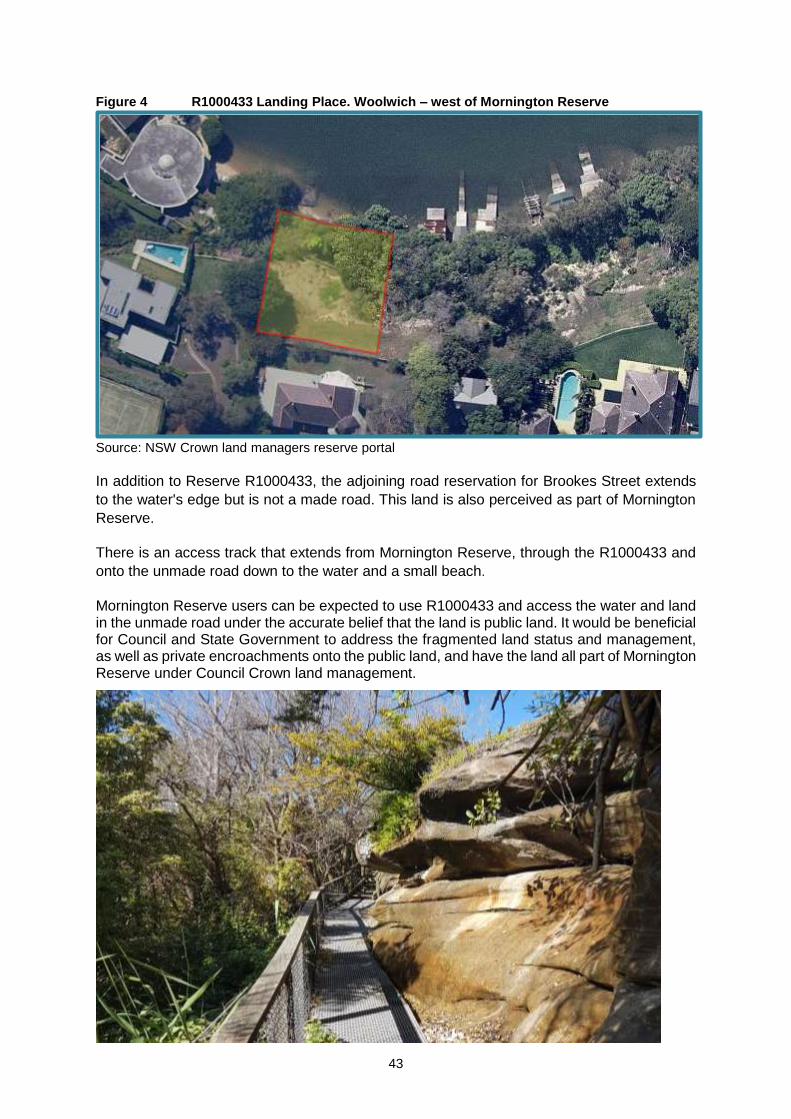
Retaining the grasses as regularly mown will allow the park area to act not only as a walkway and unstructured parkland, but also to act as a buffer between the residences and bushland. Future vegetation plantings and management should maintain the open park amenity. Incorporating natural and endemic grasses and ground-cover plants at the edges of natural area and park interface will achieve this. However, the park area should retain its focus on thoroughfare, sightlines and passive leisure such as picnicking, as well as open landscape space between residences and bushland. There is a small area of Council-owned community land on the foreshore at the eastern end of the reserve (Lot 4 DP 607282). The pathway at this end of Mornington Reserve connects with Vernon Street and forms part of the Great North Walk. There is another Crown reserve immediate to the western edge of Mornington Reserve, shown as a green square with red-border in Figure 4. This reserve is perceptively part of Mornington Reserve but is a reserve (R1000433) for the purpose of 'Landing Place’ and under the direct management of the Minister administering the CLM Act.
43
Figure 4 R1000433 Landing Place. Woolwich – west of Mornington Reserve
Source: NSW Crown land managers reserve portal
In addition to Reserve R1000433, the adjoining road reservation for Brookes Street extends
to the water's edge but is not a made road. This land is also perceived as part of Mornington
Reserve.
There is an access track that extends from Mornington Reserve, through the R1000433 and
onto the unmade road down to the water and a small beach.
Mornington Reserve users can be expected to use R1000433 and access the water and land in the unmade road under the accurate belief that the land is public land. It would be beneficial for Council and State Government to address the fragmented land status and management, as well as private encroachments onto the public land, and have the land all part of Mornington Reserve under Council Crown land management.

44
Murray Prior Reserve
Murray Prior Reserve is a small reserve situated on the north side of the junction of Tarban
Creek's entry into the harbour and Tarban Bay. See Figure 5. The reserve is predominantly
Natural Area – Bushland category (see Section 7.2) with a Natural Area – Foreshore (see
Section 7.6) edge to Tarban Bay.
Figure 5 Murray Prior Reserve
Source: NSW Crown land managers reserve portal

45
The Park category area is a small section, approximately 500 m2 of the reserve's total 6,200
m2, along George Street, effectively a street frontage and entrance to the larger reserve. This
area is mown grass with wood fencing along George Street and a manicured hedge that
borders the park from the natural areas. There is a park name sign and some heritage
interpretive signage near the relatively unmarked and discreet entrance leading down into the
larger reserve.
A small portion of George Street appears to encroach on Murray Prior Reserve in the north
east corner. See Figure 5. Council intends to formalise the status of that portion of the reserve
as a public road by acquisition.
6.2 Key management issues
The following pressures and opportunities influence management of the areas categorised as
Park and will be addressed in the ongoing management and assessment of the land.
Landscape Character - design, grounds and vegetation management
The character of a park landscape and the associated available amenities are important
features in the community appreciation of the reserves. The landscape setting, including the
appropriate supply and availability of a range of facilities such as seating and table, shade,
play equipment, paths, signage and amenities buildings such as toilets, provide support and
opportunity to further enhance and make safe the park landscape.
• Landscape amenity and aesthetics
Park landscape needs to be varied, usable and accessible to a range of community
members and groups. View lines and scenic design can vary from long range and open
views to the close and carefully designed and managed smaller areas that create a
sense of safety as well as variation.
• Park furniture and other structures
The supply of park furniture and structures assists in the safe enjoyment of parks and
enables a range of activities and opportunities for recreation. Seating, tables, BBQs,
shade structures, pathways and bridges, rubbish containers and signage are typically
afforded to provide the basis for a range of human age group activity, social family and
group interaction.
• Playgrounds, fitness equipment and skate parks
Parks provide an excellent location for many types of play and fitness infrastructure
associated with casual and informal recreation, health and fitness, and the
development of motor skills for all ages and stages of human development.
• Trees, vegetation and landscape protection
Tress, shrub and flower planting as well as grass or turf space in parks provides a
respite from the built environment. Opportunities increase for community members to
relax in natural surroundings, whilst experiencing open-air recreation and leisure.
Open space, natural area and park vegetation provides a range of environmental benefits
such as wind reduction, water conservation and increased habitat and biodiversity advancing
community health such as shade and aesthetic landscaping benefits.

46
Trees provide shade, landscape variation as well as a range of aesthetic benefits in the
changing seasons. Planting of shrubs and flower beds can define space or add colour and
texture to the landscape, reducing landscape monotony and providing seasonal variation.
Those reserves where a Park category is assigned adjacent to a Natural Area category and
landscaping, (such as at Mornington and Murray Prior reserves) will need to be recognised as
Natural-Style Parklands, providing for access and use as parks but also operating, particularly
at Mornington Reserve, as a buffer to reduce human impacts and invasive species into the
natural area bushland from adjacent residential and walkway uses.
Culture and heritage
Hunter’s Hill has a significant cultural and environmental heritage associated with its peninsula
and riverine environments.
Evidence of millennia of indigenous occupation and culture over the high points, harbour and
riverine interfaces can be found, predominantly in Natural Area category land. It is important
to recognise this pre-European ownership and settlement as well as protect any identified
locations, sites and artefacts of Aboriginal culture and occupation.
The European settlement of Hunter’s Hill has a strong maritime theme with many sites of
Crown reserves used as wharfs, landing places and waterway travel. The areas around
Clarke's Point are a prime example of the maritime history and retention of heritage and culture
in the public spaces and landscape.
The high quality and presence of bushland and aquatic interface plant species require
conservation and restoration. Hunter’s Hill community and Council have demonstrated
commitment to bushland conservation as evidenced by the preservation of Kelly's Bush 50
years ago, and other areas of indigenous landscapes and vegetation.
Items of State and Local heritage significance need to be recognised in park and public space
use, planning and management. It is important to not only conserve and protect items and
areas of cultural and environmental heritage but to also provide opportunities to interpret and
experience these heritage values.
Connectivity with other open space reserves and parks
Improved integration of the network of parks with sports grounds and nearby land uses of
residential, schools, or other local open space will aid community use and assist in service
delivery. It is important for those areas where there are natural area values to have
increased linkages to other similar reserves and open spaces for biodiversity and habitat
linkage development.
Public access and multiple use
All the land categorised as Park are Crown reserves with a mix of purposes. A number of the
purposes are historical and no longer relevant such as wharf site, public wharf, and wharfage.
These reserves have either not realised their original purpose or are now parks adjacent to
existing wharves. Murray Prior Reserve also fits this category as the purpose of public baths
at that reserve reflects the former netted baths area that no longer exist.

47
Apart from the reserves with the broad and general purpose of public recreation, the other
purposes reflect the nature of the current facilities and opportunities, e.g: boatshed or public
baths, and access.
This primary purpose of the reserves coupled with the multi-use and equitable access
objectives of the CLM Act sets the framework for open and accessible use of the land and
facilities. Equity of access is fundamental to parks use for all age groups and levels of ability,
particularly to promote independence and social and economic inclusion of people with
disabilities.
Aged, less mobile and people with disability, parents with young children or prams, people
using wheelchairs or needing ambulatory support, all have a right to access and enjoy parks.
Accessible car parking, paving and level changes, suitable facilities, sightlines, equal access
furniture and equipment help to make a park an equally accessible environment for individuals
who may feel constrained in the use of a park when these accessible and designed facilities
are not available.
Barriers to access such as lack of car parking or high steps, guttering, soft or unsteady
surfaces should be limited, and park design and improvements/developments should
incorporate equitable access as a priority.
Development and uses
Developments in parks and public spaces should be in accordance with reserve purposes,
category objectives and subject to Council planning assessment as may be required under
the Hunter’s Hill LEP.
Any proposed development that would have a significant impact on the landscape, amenity or
commerciality of the park or public space should be publicly exhibited through a site
Masterplan.
Dogs in parks and public spaces
Walking and playing with dogs is a popular recreational activity with physical and mental health
benefits. The use of Council footpaths, parks and reserves for casual dog walking and play is
generally accepted by the community.
The Companion Animals Act 1998 provides the framework for management of dogs in NSW.
The aim of this Act is to provide for effective and responsible care and management of
companion animals, and responsible and co-operative management of dogs in public spaces.
Under the Companion Animals Act, and subject to any Council signage, dogs may be walked
anywhere on a lead, except within 10 metres of:
• a children’s playground or
• a food preparation area.
Council provides five (5) Dog Off-Leash areas in its Municipality.
Dogs in public places must be kept under effective control at all times. This includes in public
recreation areas. A person in charge of a dog must remove and dispose of any faeces
produced by their dog whilst in a public space. Additionally, a dog must not inflict physical
harm to other people, animals or property.

48
Signage and clear notices about any restrictions Council must, or chooses to, introduce will
assist the community to understand and comply with safe and responsible dog and park use.
Personal Trainers, and small event bookings
Personal trainers, fitness groups and small event bookings can be accommodated in parks
under licence or hiring arrangements. These events should be subject to time and area limited
with use conditions to enable use to help reduce conflicts of use with the general public.
Play Equipment and Recreation Equipment
Play equipment may be installed or removed subject to Council exhibited masterplans at
suitable sites. Equipment shall be regularly maintained and kept in a safe condition in
accordance with the relevant Australian Standard and Council’s Playspace Strategy.
Amenity Provision
Buildings and amenities may be provided where consistent with the need to facilitate the
recreational use of the land. Buildings and amenities should be regularly cleaned and
maintained in a tidy condition in accordance with any adopted Council procedures manual.
Public toilets are only provided at sites where there is a significant number of users.
Safe maintenance and upgrade of buildings, structures and facilities Systemic, formally planned and implemented upgrade and maintenance of parks and
associated infrastructure including buildings, amenities, viewing areas and access is important
to ensure reserve facilities and opportunities continue to meet necessary user standards for
current use patterns and to meet future use needs.
Passive recreation infrastructure maintenance can facilitate increased use of associated and
connected public spaces by the local community and visitors to the area, including shared use
path linkages, open space furniture, landscape, public art and signage.
Any areas held under lease, licence or regular occupancy shall be maintained by the regular
occupant. Existing assets on the land should be identified and measures taken so they are
maintained in a satisfactory manner. Council may make arrangements for community groups
to undertake maintenance for specific facilities on the Council’s behalf.
Safety and Risk Management
Council is responsible for the safety of users and for general public park use. Booking, hire or
user agreement conditions transfer a certain level of the safety and risk management
responsibilities to those users.
Council preparation of a risk management and harm minimisation strategy for its parks,
supplemented by an annual audit of parks and facilities for development of a repairs and
maintenance schedule will assist in the management and reduction of risk along with benefits
for public and user safety.
Event Management
The largest reserve in the Park category collection, Valentia Street Reserve, is the only park
with the size and capacity to provide opportunities for a range of events and community
activities that enrich the community and provide for celebration and festivities. Council is

49
responsible to ensure that events and organised activities are safe for the public and
providers/organisers, as well as avoiding damage to the reserve and its facilities by users.
Environmental Management – energy, water use and run-off management, including
pesticides
Operational costs for energy and water use may be reduced through a range of environmental
means that warrant Council investigation. Environmental sustainability options and
infrastructure, including alternate energy sources, energy and water use efficiency practices
and systems, including timing systems or regulated watering practices can be implemented to
reduce costs and wastage.
Surface water run-off loss reduction and collection practices not only optimise water
application and reduce stormwater loss but can also provide for alternate sources of town or
reticulated water supplies during periods of limited availability.
Council, and user organisations with occupancy and use agreements such as lessees, should
have agreed and sustainable fertiliser and pesticide application and management plans and
practices to limit dispersal into watercourse and water bodies, including the limitation of human
contact from aerial or surface exposure.
Feral animals, pest animals and priority weeds Feral animals, pest animals and priority weeds require management in parks, especially if the
land interfaces with natural areas or is adjacent to residential or commercial land uses. The
impact of feral animals, pest animals and priority weeds can be significant on local habitat and
biodiversity, as well as human well-being and health.
Control of pest animals and priority weeds should be undertaken on a regular and
programmed basis in compliance with legislation and council policies.
Signage and Advertising
Site-based signage provides clear regulatory, as well as user conditions of use, including
alcohol free zones, permissible and non-permissible activities, dog leash or leash-free zones,
times of specific uses, and internal site or facility directions.
It is important to create a reserve environment that is enjoyable for all users. Excessively noisy,
dangerous or anti-social activities can be regulated and minimised through use of signage and
ranger or ordinance officer monitoring.
Interpretive and explanatory signage, such as: simple tree genus or species name plates, and
heritage or environmental information and education can enhance park use experiences as
well as help to provide education or awareness for the community.
Advertising signage at Crown reserves should be ancillary or supportive of the reserve
purposes and activities.
Fences
Fences may be constructed and shall be in accordance with any standards or guidelines
adopted by the Council. Normally, as provided for in the Dividing Fences Act, boundary fences
are the responsibilities of adjoining owners to construct and maintain, and Council does not
contribute to fencing boundaries to private land where adjoining public parks and reserves
occur.

50
Lighting
Where appropriate, adequate lighting shall be provided on the land to ensure public safety
and security for buildings and amenities as far as possible. Night lighting should provide for
safe passage through parks without being intrusive on surrounding residential areas.
Traffic and vehicle access and car parking management
The majority of Park category reserves have either limited or no on-site parking, with the
availability of car parking on street. Woolwich Baths Reserves has limited street parking
adjacent to the reserves, as does the western end of Mornington Reserve. It is important that
Council manage the needs of reserve users and visitors with regard to parking opportunities,
especially for individuals with disabilities and other special interest groups, while balancing the
street parking needs of residential property owners.
Fees and charges/conditions of hire Council publishes an annual schedule of fees and charges for a range of goods and services
provided by Council and its organisation sections. Ensuring the inclusion of fees and charges
in Council's annually published schedule for parks will provide the general community and
user groups with clarity and budgetary assurance for short-term or casual hiring.
Clear and published conditions of hire and use, including permissible uses, times and user or
hirer responsibilities, provides clarity for users and the community of access and use, user
responsibilities and availability of areas within the Parks.
Encroachment on Public Land
Encroachments on public land, once identified, should be resolved as quickly as possible to
minimise the impact of unlawful use or unauthorised developments on the reserves. This is a
notable occurrence along the foreshore reserves in this PoM.

51
6.3 Management framework for areas categorised as Park
Table 6.3 below outlines the management objectives or desired outcomes for Park areas, means and strategies for their realisation, and means
of assessment and review by Council.
Table 6.3 Action plan for Reserves categorised as Park
MANAGEMENT
ISSUES
S.36(3)(B)
OBJECTIVES & PERFORMANCE TARGETS
S.36(3)(C)
MEANS OF ACHIEVEMENT OF OBJECTIVES
S.36(3)(D)
MANNER OF ASSESSMENT OF
PERFORMANCE
LANDSCAPE DESIGN,
GROUNDS AND
VEGETATION
MANAGEMENT
– Provide landscape amenity and
environmental benefits at parks and
community facilities.
– Trees and shrubs health maintained,
and public risk managed.
– Grass and turf maintained to user
requirements and standards.
– Shade, either natural or constructed,
provided at all parks that include
playgrounds.
– Outdoor fixtures – seats, tables,
bins, provided at all sites where
outdoors space is associated with
significant visitor use.
– Play equipment provided at sites
where children are substantial
number of visitors or users.
– Retain and maintain existing trees and
vegetation in parks for environmental and
community benefit.
– Prepare landscape masterplans for high
use or significant parks.
– Implement vegetation management plans
where parks abut natural area category
land for environmental benefits such as
wind reduction, water conservation and
increased habitat and biodiversity.
– Review of outdoor spaces associated with
facilities and building to evaluate shade
needs and provision and outdoor fixture
provision.
– Review of facilities and sites with
substantial numbers of children and
teenagers to ensure adequate provision of
play equipment and suitable health and
leisure fixtures.
– Council preparation of landscape
masterplans for high use or
significant parks and community
facilities.
– Council preparation of vegetation
management plans at any
identified parks for retention and
improvement of existing
vegetation.
– Installation of shade structures or
increased use of shade trees to
meet shade and sun protection
needs at parks with playgrounds.
– Installation of park and outdoor
fixtures, including play, leisure and
health equipment.
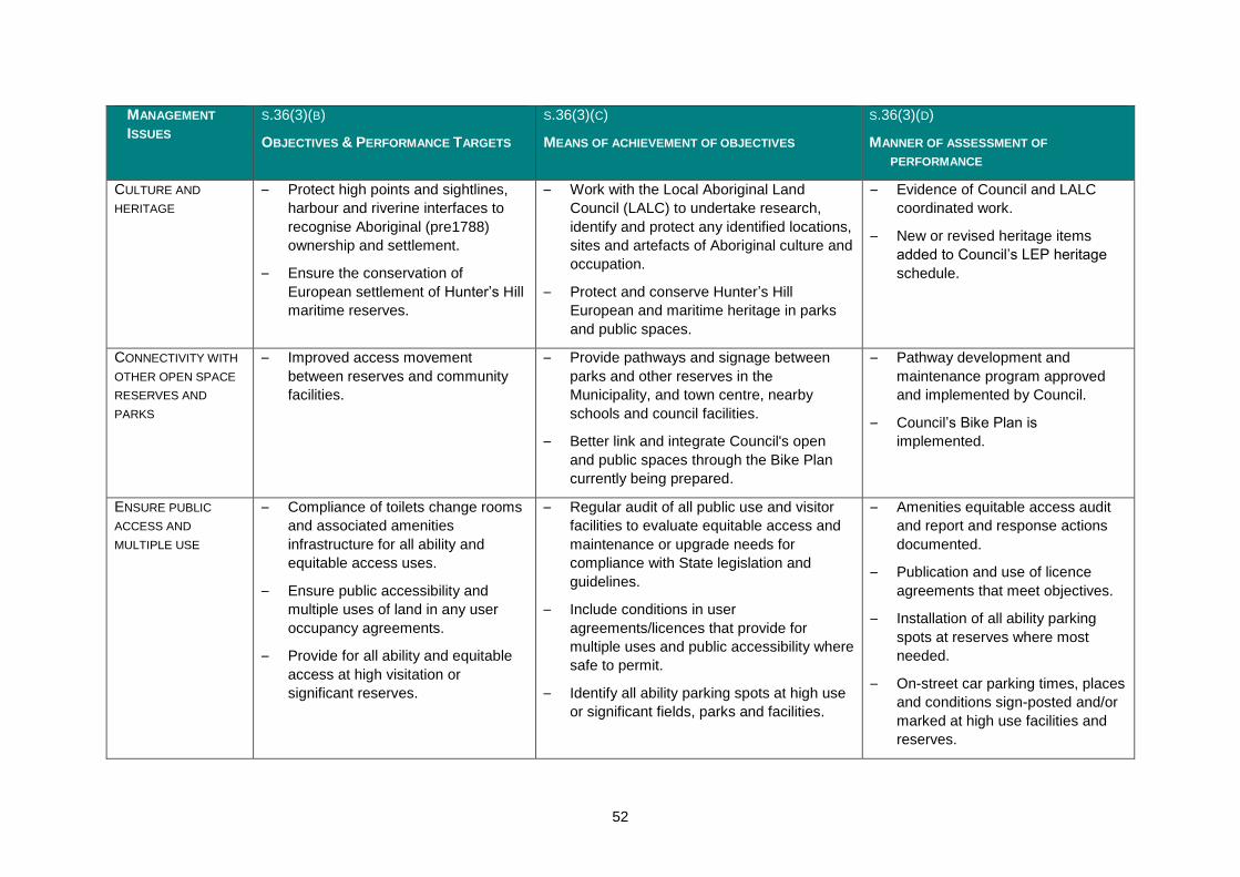
52
MANAGEMENT
ISSUES
S.36(3)(B)
OBJECTIVES & PERFORMANCE TARGETS
S.36(3)(C)
MEANS OF ACHIEVEMENT OF OBJECTIVES
S.36(3)(D)
MANNER OF ASSESSMENT OF
PERFORMANCE
CULTURE AND
HERITAGE
– Protect high points and sightlines,
harbour and riverine interfaces to
recognise Aboriginal (pre1788)
ownership and settlement.
– Ensure the conservation of
European settlement of Hunter’s Hill
maritime reserves.
– Work with the Local Aboriginal Land
Council (LALC) to undertake research,
identify and protect any identified locations,
sites and artefacts of Aboriginal culture and
occupation.
– Protect and conserve Hunter’s Hill
European and maritime heritage in parks
and public spaces.
– Evidence of Council and LALC
coordinated work.
– New or revised heritage items
added to Council’s LEP heritage
schedule.
CONNECTIVITY WITH
OTHER OPEN SPACE
RESERVES AND
PARKS
– Improved access movement
between reserves and community
facilities.
– Provide pathways and signage between
parks and other reserves in the
Municipality, and town centre, nearby
schools and council facilities.
– Better link and integrate Council's open
and public spaces through the Bike Plan
currently being prepared.
– Pathway development and
maintenance program approved
and implemented by Council.
– Council’s Bike Plan is
implemented.
ENSURE PUBLIC
ACCESS AND
MULTIPLE USE
– Compliance of toilets change rooms
and associated amenities
infrastructure for all ability and
equitable access uses.
– Ensure public accessibility and
multiple uses of land in any user
occupancy agreements.
– Provide for all ability and equitable
access at high visitation or
significant reserves.
– Regular audit of all public use and visitor
facilities to evaluate equitable access and
maintenance or upgrade needs for
compliance with State legislation and
guidelines.
– Include conditions in user
agreements/licences that provide for
multiple uses and public accessibility where
safe to permit.
– Identify all ability parking spots at high use
or significant fields, parks and facilities.
– Amenities equitable access audit
and report and response actions
documented.
– Publication and use of licence
agreements that meet objectives.
– Installation of all ability parking
spots at reserves where most
needed.
– On-street car parking times, places
and conditions sign-posted and/or
marked at high use facilities and
reserves.

53
MANAGEMENT
ISSUES
S.36(3)(B)
OBJECTIVES & PERFORMANCE TARGETS
S.36(3)(C)
MEANS OF ACHIEVEMENT OF OBJECTIVES
S.36(3)(D)
MANNER OF ASSESSMENT OF
PERFORMANCE
– Delineate on-street parking for more
efficient use of the street, enable
parking close to the facilities.
– Identify high use grounds and facilities to
clearly mark on-street parking limits and
times.
DOGS ON
RESERVES/PARKS
AND COMMUNITY
FACILITY OPEN
SPACE
– Ensure dog use ability in parks and
reserves, while meeting compliance
with State legislation.
– Manage dog walking and play on
and around playgrounds, food
preparation areas, footpaths, parks
and reserves.
– Install signage including restricted areas,
particularly on playing fields, but with an
emphasis on no dogs within 10 metres of:
o a children's playground or
o a food preparation area.
– Provide at least one leash-free dog area in
the Municipality.
– Publish animal and dog handling guidelines
on Council website.
– Signage installed.
– leash-free dog areas in
Municipality managed.
– Council website publication of
companion animal and dog
handling rules and regulations.
PERSONAL
TRAINERS, AND
SMALL EVENT
BOOKINGS
– Personal trainers, fitness groups
and small event bookings are safely
conducted with minimal impacts on
other reserve users and adjacent
residences.
– Personal trainers, fitness groups and small
event bookings are accommodated in
parks under licence or hiring
arrangements, subject to time and area
limited with use conditions to enable use to
limit conflicts of use with the general public.
– Licence system and documents
prepared and used for personal
trainers, fitness groups and small
event bookings.
AMENITY PROVISION – Amenity blocks are available at sites
of high or frequent use.
– Amenities provided are kept clean
and accessible to users and visitors
during daylight hours and at high or
frequent visitation sites during
facility or site opening hours.
– Identify high user and visitor facilities and
sites to evaluate amenities provision and
supply to meet needs of community and
visitor experience.
– Regular inspection and maintenance
regime that is clearly published and
provides contact details for community and
visitor maintenance requests.
– Analysis of user and visitor
satisfaction surveys.
– Relevant Council Director
approves maintenance program
and is accountable for
documenting outcomes and
monitoring of contact queries and
complaints.

54
MANAGEMENT
ISSUES
S.36(3)(B)
OBJECTIVES & PERFORMANCE TARGETS
S.36(3)(C)
MEANS OF ACHIEVEMENT OF OBJECTIVES
S.36(3)(D)
MANNER OF ASSESSMENT OF
PERFORMANCE
– Amenities are maintained for safety,
usability and modern standard.
SAFE MAINTENANCE
AND UPGRADE OF
BUILDINGS,
STRUCTURES AND
FACILITIES
– Maintain buildings, parks and
community facilities to required
standards for users and public
safety.
– Regular repairs, painting and
maintenance.
– Safe electrical systems.
– Sustainable water supply.
– Fire systems compliance with NSW
Standards.
– Implement asset maintenance plans for all
park and community facilities buildings
structures and landscape assets.
– System to receive reports/requests for
maintenance needs is clearly published
and acted upon.
– Annual electrical, gas and water supply
systems check and review for maintenance
and upgrade needs.
– Fire safety systems check for maintenance
or upgrade to meet standards and codes
by local Fire brigade or registered
authority.
– Asset management plans in place
and implemented.
– Annual electrical, gas and water
supply systems check and review
for maintenance and upgrading
needs.
– Annual fire safety systems check
and response actions documented.
SAFETY AND RISK
MANAGEMENT
– Minimise public safety and user risk
at parks and adjacent Council open
or public spaces.
– Risk management and harm minimisation
strategy prepared for parks, any
community facilities and adjacent public
spaces.
– Improved lighting for security along
pedestrian walkway/lanes.
– Identification of community or individual
use of the reserve that may risk others e.g
electricity cords from residential properties
into the reserve, discharge of waste water,
uncontrolled weed application, fencing or
encroachment.
– Preparation of risk minimisation
strategy.
– Installation of additional lighting,
subject to resources and funding,
to increase safety along main
pedestrian pathways and
thoroughfares.
– Council maintenance team
reporting system implemented.

55
MANAGEMENT
ISSUES
S.36(3)(B)
OBJECTIVES & PERFORMANCE TARGETS
S.36(3)(C)
MEANS OF ACHIEVEMENT OF OBJECTIVES
S.36(3)(D)
MANNER OF ASSESSMENT OF
PERFORMANCE
EVENT
MANAGEMENT
– Ensure any events have event
management licenses or permits
through bookings or hiring.
– Include event management plans,
traffic management plans, waste
and public safety plans in licence
conditions.
– Maintain clear and published
booking and hire system for events.
– Prepare and use event licences or permits
with inclusion of event management plans,
traffic management plans, waste and public
safety plans.
– Publish booking and hire system
arrangements on Council website with
clear dates, times and contact details for
users and community groups.
– Event licences and permits to
include conditions for event and
traffic, user and organisation
vehicle management plans
prepared in liaison with Local Area
police.
– Publication and use of licences
with conditions that address
objectives.
– Council website publication of
booking and hire systems including
seasonal dates and conditions of
application.
– All hire or booking agreements
have Council officer contact details
to facilitate user benefits.
ENVIRONMENTAL
MANAGEMENT AND
SUSTAINABILITY
– Reduction in operational costs for
energy and water use through a
range of environmental and
sustainable means to reduce costs
and wastage.
– Surface water run-off loss reduction
and collection practices to optimise
water use and reduce stormwater
loss.
– Limit dispersal of sustainable
fertiliser and pesticide into less
robust environmental systems such
– Investigate implementation of alternate
energy sources such as solar electricity
and heating systems at facilities on sites
– Energy and water use efficiency practices
and systems, including:
o timing systems or regulated
watering practices:
o Council investigation of
investment into water
efficiency actions
– Council investigate and consider
options for cost-efficiency and
sustainability of:
o sources such as solar
electricity and heating
systems at facilities on
sites
o energy and water use
efficiency practices
and systems, including
timing systems or
regulated watering
practices

56
MANAGEMENT
ISSUES
S.36(3)(B)
OBJECTIVES & PERFORMANCE TARGETS
S.36(3)(C)
MEANS OF ACHIEVEMENT OF OBJECTIVES
S.36(3)(D)
MANNER OF ASSESSMENT OF
PERFORMANCE
as watercourse and water bodies,
and limit human contact from aerial
or surface exposure.
– Development and maintenance is
undertaken with environmentally
sustainable practices and within
Australian or NSW standards.
– All hazardous materials and
chemicals are handled, stored and
used in line with NSW legislation
o Safe re-use of effluent and
grey waters
– All chemical storage, use and handling to
be certified by current NSW authority, e.g:
WorkSafe NSW and initiatives to replace or
reduce use investigated.
o investment into water
efficiency actions
o safe re-use of effluent
and grey waters
– Council implements sustainable
fertiliser and pesticide application
and practices.
– Chemical storage, use and
handling certification and response
actions reported to Council.
FERAL ANIMALS,
PESTS AND NOXIOUS
WEEDS
FERAL ANIMALS,
PESTS AND NOXIOUS
WEEDS
– Removal of pests and priority weeds
is undertaken and feral animals
captured, removed or reduced in
compliance with legislation and
council policies.
– User/occupants to provide annual report on
pests, priority weeds and feral animal
management.
– Annual reports provided to relevant
Council Director.
PLAY EQUIPMENT
AND RECREATION
EQUIPMENT
– Provide play, recreation and fitness
equipment at appropriate locations.
– Provision of equipment that will result in a
substantial increase in visitation (e.g
Regional playground) will be subject to
Council exhibited masterplans.
– Equipment shall be regularly maintained
and kept in a safe condition in accordance
with the relevant Australian Standard and
Council’s playground and equipment
upgrade plans or policies.
– Council adopted master plans for
any substantial installation of play,
recreation and fitness equipment.
– Regular maintenance and upgrade
program.
SIGNAGE AND
ADVERTISING
INCLUDING SITE
BASED DIRECTIONAL
– Provide clear guidance to park and
community facility users on reserves
conditions of use, including alcohol
free zones, permissible and non-
– Site-based facility, structure, field and open
space regulatory signage to address
activity, including:
– Installation of regulatory signage at
high use or visitation parks and
community facilities.

57
MANAGEMENT
ISSUES
S.36(3)(B)
OBJECTIVES & PERFORMANCE TARGETS
S.36(3)(C)
MEANS OF ACHIEVEMENT OF OBJECTIVES
S.36(3)(D)
MANNER OF ASSESSMENT OF
PERFORMANCE
permissible activities, dog leash or
leash-free zones, times of specific
uses, and internal site or facility
directions.
– Advertising signage at Crown
reserves should be ancillary or
supportive of the reserve purposes
and activities and is not generally
acceptable for solely external
advertising purposes.
o alcohol free zones,
o permissible and non-
permissible activities,
o dog leash or leash-free zones,
o times of specific uses
– Evaluate any signage proposals for Crown
reserves to ensure advertising is ancillary
to reserve use and management.
FENCES – Maintain safe and adequate fencing
and park land definition.
– Resolve ambiguity between private and
public lands at the interface of reserves to
ensure public access to public land and
minimise risk.
– Fences may be constructed and shall be in
accordance with the Dividing Fences Act.
– Ambiguity identified and resolved
between private and public land
ownership.
LIGHTING – Lighting is provided for visitor and
user safety in parks, any buildings
and structures, and car parks where
night/dark use is present.
– Lighting impact on neighbours and
other users not requiring lighting is
minimised.
– Review of facilities and structures to
evaluate lighting needs and gaps for safety
and to meet users and visitor needs.
– Ensure lighting spill and brightness
complies with current and acceptable
industry standards.
– Lighting for evening and night grounds
uses conform to Australian and
industry/sports standards.
– Lighting needs review and
implementation program prepared
and provision priorities reported..
– Night/dark safe lighting needs
review conducted, incorporating
CPTED principles and provision
priorities reported.
– Relevant Council Director to
manage review and ensure
appropriate response/actions.

58
MANAGEMENT
ISSUES
S.36(3)(B)
OBJECTIVES & PERFORMANCE TARGETS
S.36(3)(C)
MEANS OF ACHIEVEMENT OF OBJECTIVES
S.36(3)(D)
MANNER OF ASSESSMENT OF
PERFORMANCE
FEES AND CHARGES /
CONDITIONS OF HIRE
– Ensuring the inclusion of fees and
charges in Council's annually
published schedule for parks will
provide the general community and
user groups with clarity and
budgetary assurance for short-term
or causal hiring.
– Clear standard user and hire
agreements will provide clarity for
users and the community of access
and use, user responsibilities and
availability of areas within parks.
– Annual publication of fees and charges for
uses and hire of parks and public spaces.
– Clear and published conditions of hire and
use, including permissible uses, times and
user or hirer responsibilities.
– Fees and charges annual
publication.
– Standard hire and use agreements
with conditions and responsibilities
included.
ENCROACHMENT ON
PUBLIC LAND
– Encroachments on public land, once
identified are resolved as quickly as
possible to minimise the impact of
unlawful use or unauthorised
developments on the reserves.
– Council audit and subsequent rectification
of any identified encroachments or illegal
developments on Council-owned and
managed open and public spaces.
– Council audit undertaken.
– Sites for rectification identified and
suitable action taken.

59
6.4 Permitted development and use
The table below outlines the management requirements, permitted development and uses of the
reserves categorised as Park.
Table 6.4 Permissible use and development of community land categorised as Park, subject to
Council approval and any required development consent.
PURPOSE/USE DEVELOPMENT TO FACILITATE USES
– Organised and unstructured
recreation activities
– Community events and
gatherings
– Active and passive recreation
including children’s play and
cycling
– Group recreational use, such
as picnics and private
celebrations
– Eating and drinking in a
relaxed setting
– Publicly accessible ancillary
areas, such as toilets
– Festivals, parades, markets,
fairs and similar
– Exhibitions
– Events and gatherings
– Filming and photographic
projects
– Busking
– Public address (speeches)
– Development for the purposes of improving access, amenity and
the visual character of the reserve and its uses, for example
paths, public art, pergolas
– Development for the purposes of active recreation such as play
equipment, exercise equipment, bike racks
– Amenities to facilitate the safe use and enjoyment of the reserve,
for example picnic tables, BBQs, sheltered seating areas
– Landscaping and finishes, improving access, amenity and the
visual character of the reserve
– Café or refreshment areas (kiosks) including external seating
– Lighting, seating, toilet facilities, paved areas
– Hard and soft landscaped areas
– Storage sheds
– Car parking and loading areas
– Commercial development that is sympathetic to and supports use
in the area, for example hire of recreation equipment
– Toilet/shower facilities
– Shade structures
– Storage ancillary to recreational uses, community events or
gatherings, and public meetings
– Locational, directional and regulatory signage
– Heritage and cultural interpretation, e.g: signs
– Equipment sales/hire areas ancillary to the reserve purposes and
the approved uses
– Advertising structures and signage (such as A-frames and
banners) that:
o relate to approved uses/activities
o are discreet and temporary
o are approved by the council
– Water-saving initiatives such as stormwater harvesting, rain
gardens and swales
– Energy-saving initiatives such as solar lights and solar panels
– Bio-banking and carbon sequestration initiatives
60
6.5 Express authorisation of leases and licenses and other estates
Under section 46(1)(b) of the LG Act, leases, licences and other estates formalise the use of community land. A lease, licence or other estate may be granted to organisations and persons, community groups, sports clubs and associations, non-government organisations, charities, community welfare services, non-profit organisations and government authorities.
The lease or licence must be for uses consistent with the reserve purposes, the assigned categorisation and zoning of the land, be in the best interests of the community as a whole, and enable, wherever possible, shared use of community land.
Any lease or licence proposal will be individually assessed and considered, including community benefit, compatibility with this PoM, and capacity of the community land and the local area to support the activity.
A lease is normally issued where exclusive control of all or part of an area by a user is proposed. In all other instances a licence or short-term licence or hire agreement will be issued.
Any proposed lease or licence for more than 5 years must be by tender unless it is to a non-profit organisation.
The authorisation of leases, licences and other estates for community land categorised as Park are set out in Table 6.5 in this plan of management.
6.6 Leases and licenses authorised by this plan of management
This PoM expressly authorises the issue of leases, licences and other estates over the land covered by the PoM, provided that:
the purpose is consistent with the purpose for which it was dedicated or reserved
the purpose is consistent with the core objectives for the category of the land
the lease, licence or other estate is for a permitted purpose listed in the LG Act or the LG
Regulation
the issue of the lease, licence or other estate and the provisions of the lease, licence or other
estate can be validated by the provisions of the NT Act
where the land is subject to a claim under the Aboriginal Land Rights Act 1983 (ALR Act) the
issue of any lease, licence or other estate will not prevent the land from being transferred in
the event the claim is granted
the lease, licence or other estate is granted and notified in accordance with the provisions of
the LG Act or the LG Regulation; and
the issue of the lease, licence or other estate will not materially harm the use of the land for
any of the purposes for which it was dedicated or reserved.
6.7 Short-term licences
Short-term licensing is enabled under Section 46 (1)(b)(iii) of the LG Act, and Clause 116 of the LG Regulation.
Short-term licences and bookings may be used to allow Council to program different uses of community land at different times, allowing best overall use. The LG Regulation limits the grant of short-term, casual purpose to use, or occupation that does not involve the erection of any building or structure of a permanent nature.

61
Short-term licences are authorised for the purpose of:
the playing of a musical instrument, or singing, for fee or reward
engaging in a trade or business
the playing of a lawful game or sport
the delivery of a public address
commercial photographic sessions
picnics and private celebrations such as weddings and family gatherings
filming sessions; or
the agistment of stock.
Fees for short-term casual bookings will be charged in accordance with Council’s adopted fees and charges, and current licensing policies, at the time of application.
Table 6.5 Leases, licences and other estates and purposes for which they may be granted for
community land categorised as Park.
TYPE OF TENURE
ARRANGEMENT
PURPOSE FOR WHICH TENURE MAY BE GRANTED
LEASE
LONG TERM USE
UP TO 30 YEARS
– Food and beverage outlets, such as café/kiosk areas, including seating and
tables
– Management of park areas and facilities
– Hire or sale of recreational equipment
– Cultural purposes, including concerts, dramatic productions and galleries
– Recreational purposes, including fitness classes, dance classes and games
LICENCE
LONG TERM USE
UP TO 30 YEARS
– Outdoor café/kiosk seating and tables
– Management of court or similar facilities
– Hire or sale of recreational equipment
– Recreational purposes, including fitness classes, dance classes
SHORT-TERM
LICENCE
UP TO 12
MONTHS
General and short-term or casual licences: as issued with Council formal application process, permissions and/or approvals (LG Act, S.46, LG (General) Regulation, Cl.117
– Access through a reserve
– Advertising
– Broadcasting or filming of sporting fixtures
– Catering
– Community events and festivals
– Commercial photographic sessions and filming (as defined in the LGAct 1993)
– Delivery of a public address
– Emergency occupation
– Entertainment
– Exhibitions
– Fairs, markets, auctions and similar activities
– Hiring of equipment
– Markets
– Picnics and private celebrations such as weddings and family gatherings
– Playing a musical instrument or singing for fee or reward
– Playing of a lawful game or sport
– Public performances
– Sales
– Shows
– Site investigations

62
TYPE OF TENURE
ARRANGEMENT
PURPOSE FOR WHICH TENURE MAY BE GRANTED
OTHER ESTATES This PoM allows the council to grant ‘an estate’ over community land for the provision
of public utilities and works associated with or ancillary to public utilities in accordance
with the LG Act.
Estates may also be granted across community land for the provision of pipes,
conduits, or other connections under the surface of the ground for the connection of
premises adjoining the community land to a facility of the council or other public utility
provider that is situated on community land.

63
7 NATURAL AREAS
7.1 Introduction
Natural areas are defined in clause 102 of the LG Regulation as:
• Land possessing a significant geological or geomorphological feature, landform,
representative system or other natural feature or attribute that would be sufficient to further
categorise the land as bushland, wetland, escarpment, watercourse or foreshore.
7.1.1 Core objectives
Council may then apply more specific management objectives to community land, though these
must be compatible with the core objectives for the land. Core objectives for natural areas, as
outlined in Section 36E of the LG Act, are:
• to conserve biodiversity and maintain ecosystem function in respect of the land, or the
feature or habitat in respect of which the land is categorised as a natural area; and
• to maintain the land, or that feature or habitat, in its natural state and setting; and
• to provide for the restoration and regeneration of the land; and
• to provide for community use of and access to the land in such a manner as will minimise
and mitigate any disturbance caused by human intrusion; and
• to assist in and facilitate the implementation of any provisions restricting the use and
management of the land that are set out in the Threatened Species Conservations Act
1995 (Repealed)5 or the Fisheries Management Act 1994.
5 The Biodiversity Conservation Act 2016 has replaced the repealed Threatened Species
Conservations Act 1995 however, as of January 2020, S36E of the LG Act has not been updated to
reflect this amendment. The Biodiversity Conservation Act 2016 began 25 August 2017.

64
7.1.2 Physical environment of reserves with Natural Area category
The following five reserves have been given a category of Natural Area – Foreshore or Natural
Area – Bushland (in part or whole).
Table 7.1 Reserves with a Natural Area category
RESERVE
NO.
RESERVE NAME RP IDENTIFIER
(LOTS/DP)
CROWN LAND
PURPOSE
CATEGORY HUNTER’S
HILL LEP
2012
37233
Mornington
Reserve
Lot 7341
DP 1155948
Access; Public
Recreation
Park
Natural Area - Bushland
Natural Area – Foreshore
E2
47916
Murray Prior
Reserve
Lot 7343
DP 1155920
Public Baths;
Recreation
Park
Natural Area - Bushland
Natural Area – Foreshore
E2
500284
Collingwood St
Reserve
Lot 7339
DP 1162761
Baths; Boatshed
Park
Natural Area – Foreshore
RE1
500262
(PART)
St Johns Park
(Part Boronia
Park)
Lot 829
DP 752035
Part Lot 7352
DP 1156319
Public
Recreation
Natural Area - Bushland
E2
1000442 Wharf Reserve
[Next to Kelly’s
Bush]
Lot 1
DP 1154490
Public Wharf Natural Area - Bushland
E2
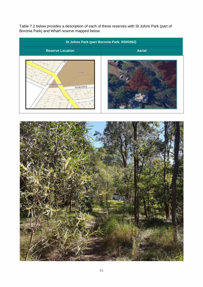
65
Table 7.2 below provides a description of each of these reserves with St Johns Park (part of
Boronia Park) and Wharf reserve mapped below.
St Johns Park (part Boronia Park: R500262)
Reserve Location Aerial

66
Wharf Reserve (Adjacent to Kellys Bush)
Reserve Location Aerial

67
Table 7.2 Description of reserves with a Natural Area category
RESERVE NAME PHYSICAL DESCRIPTION
MORNINGTON RESERVE
SEE MAPS 6.1.1 RESERVES
WITH A PARK CATEGORY
– Accessed off Brookes Street with a pedestrian laneway off Vernon Street,
Hunter’s Hill.
– Long narrow reserve on the Lane Cove River with a northerly aspect, sloping
steeply to the water, with rocky sandstone outcrops and water views.
– Boat sheds located along the intertidal zone and houses adjoin the reserve
along the southern boundary.
– Vegetation is defined as Coastal Sandstone Foreshore Forest comprising
Smooth-barked Apple, Coast Banksia and Cheese Tree. Originally,
vegetation was dry sclerophyll open forest however a thick mix of weeds and
natives, mostly mesic species has changed the vegetation structure and
function to be more closed and moist, making areas of the reserve difficult to
access, views difficult to see - changing the habitat significantly.
– No rare or threatened species have been identified on site. A formal track
from the top of the reserve to the foreshore exists in the western portion and
an informal track accessing two boat sheds exists to the east.
– An undefined track that forms part of the Great North Walk extends along
the grassy southern portion of the reserve that is mown and maintained by
Council.
– The divide between public and private properties is generally delineated by
property fences which allow views into and out of the land.
– Heritage features include Aboriginal sites (midden).
– While the whole of the reserve has been listed as a heritage item it contains
old tracks, stairs, boat sheds and landscaping features that add to the
overall heritage value and character.
MURRAY PRIOR RESERVE
SEE MAPS PG. 42
– Accessed off George Street, Hunter’s Hill. A formalised track includes stone
and wooden stairs that circulates from George Street to the foreshore and
then to the elevated western portion of the reserve with interpretative
signage.
– The site has a southerly aspect and drains to Tarban Creek and the
Parramatta River.
– The reserve includes rocky sandstone outcrops throughout and a steep drop
to Tarban Creek to the West.
– The vegetation is defined as Coastal Sandstone Foreshore Forest
comprising Smooth-barked Apple, Coast Banksia and Cheese Tree.
– The vegetation was originally dry sclerophyll open forest however a thick mix
of weeds and natives, mostly mesic species has changed the vegetation
structure and function to more closed and moist, making areas of the
reserve difficult to access, views difficult to see and changing the habitat
significantly.
– No rare or threatened species have been identified on the site
– Forty species of flora were recorded in 2020 and all were considered
common species to the area.
– The western elevated area of the reserve adjoins residential development.
– No fencing occurs in this area and it is difficult to distinguish private from
public land. This area is mown with intermittent native plantings.
– The area that gently slopes to the Creek includes interpretation signage,
dinghy storage racks and seating where visitors can enjoy extensive water
views.

68
RESERVE NAME PHYSICAL DESCRIPTION
– Stormwater and sewer overflow that drain from the surrounding area into the
reserve and the former baths has changed the vegetation to a nutrient rich
and moist environment that has encouraged thick growth of vines, bushes
and herbaceous weeds.
– Adjoining vegetation includes a thicket of mangroves that are colonising the
former baths used at the turn of last century which has gradually silted up.
– Other heritage features include Aboriginal sites (engraving grooves, cave
and midden) and an old sandstone quarry site used to construct local
buildings.
COLLINGWOOD ST
RESERVE
SEE MAPS ON PG 36
– Accessed off Collingwood Street, Woolwich and a boardwalk from Woolwich
Baths to the Baths pier.
– The site has a northerly aspect and slopes to the foreshore of the Lane Cove
River.
– The reserve includes car access to the foreshore where boat sheds have
been erected in the intertidal area.
– The vegetation includes thick herbaceous weeds and native plants. No
vegetation community has been defined on the site.
– An active bushcare group is rehabilitating the site and adjoining public land.
– No rare or threatened species have been identified.
ST JOHNS PARK
(PART BORONIA PARK)
SEE MAPS PG. 61
– The Park forms a small triangle block bounded by Ryde Rd, Augustine St
Hunter’s Hill and residential property.
– The Park gently slopes downhill towards Ryde Road and has higher nutrient
shale / sandstone soils with no exposed rock formations.
– A significant park in the Municipality for the presence of Sydney Turpentine
Ironbark Forest (STIF) listed in Part 1 of Sch 2 of the Biodiversity
Conservation Act 2016 and under the Commonwealth EPBC Act 1999 as a
Critically Endangered Ecological Community.
– The STIF is in reasonable condition and structure for an open woodland,
given its small size. It is mapped under Hunter’s Hill LEP 2012 as of High
Biodiversity Significance and as a Conservation Area – General.
– The Park contains the locally significant species Angophora floribunda
(Rough-barked Apple). There are no individual rare or threatened species
identified on the site.
– The Park is managed by bushland contractors from the National Trust.
– One informal track traverses from the car park on Ryde Road to Augustine
St.
– The park includes 2 exclusive use car parks for Sydney Water to access and
maintain the sewer infrastructure below ground, some signage, barrier
fencing and old park furniture.

69
RESERVE NAME PHYSICAL DESCRIPTION
WHARF RESERVE
[NEXT TO KELLY’S BUSH]
SEE MAPS PG. 62
– Small rectangle block has no direct street access or foreshore access.
– The reserve has a southern aspect and is adjoined by Kelly’s Bush to the
east, residential development to the north and west and Parramatta River to
the south. A mesh fence has been constructed along the western boundary
clearly delineating property boundaries and restricting access.
– Access is possible via Kelly’s Bush, but no formal tracks allow access to the
reserve.
– The site slopes steeply to the River via a sandstone cliff. The slope includes
sandstone outcrops.
– The remaining vegetation adjoining Kelly’s Bush is defined as Coastal
Sandstone Foreshore Forest that typically comprises Smooth-barked Apple,
Coast Banksia and Cheese Tree. The vegetation was originally dry
sclerophyll open forest however a thick mix of weeds and mesic native
species changed the vegetation structure and function to more closed and
moister environment.
– The site has recently been extensively cleared of vegetation without
authorisation.
– No rare or threatened species have been identified on the site.
– The site has some weedy vegetation and indicates some resilience as
natives are germinating following the site clearing.

70
7.1.3 Development and use
The use and development of community land should be compatible with the legislated purpose of
the land and the wider community context.
Hunter’s Hill Council encourages a wide range of uses of community land and intends to facilitate
uses which increase the activation of its land.
The use of community land is often supported by appropriate ancillary development such as amenity
blocks or food kiosks.
The general types of uses which may occur on community land categorised Natural Area – Bushland
and Natural Area – Foreshore, and the forms of development generally associated with those uses,
are set out in Table 7.5 & 7.9 in Sections 7.5 and 7.9, respectively. These facilities on community
land may change over time, reflecting the needs of the community.
7.1.4 Express authorisation of leases, licences and other estates
The LG Act requires that any lease, licence or other estates over community land must be
expressly authorised by a PoM.
Under section 46(1)(b) of the LG Act, leases, licences and other estates formalise the use of
community land. A lease, licence or other estate may be granted to organisations and persons,
community groups, sports clubs and associations, non-government organisations, charities,
community welfare services, non-profit organisations and government authorities.
The lease or licence must be for uses consistent with the reserve purposes, the assigned
categorisation and zoning of the land, be in the best interests of the community as a whole, and
enable, wherever possible, shared use of community land.
Any lease or licence proposal will be individually assessed and considered, including community
benefit, compatibility with this PoM, and capacity of the community land and the local area to
support the activity.
A lease is normally issued where exclusive control of all or part of an area by a user is proposed.
In all other instances a licence or short-term licence or hire agreement will be issued.
Any proposed lease or licence for more than 5 years must be by tender unless it is to a non-profit
organisation.
This PoM expressly authorises the issue of leases, licences and other estates over the land
covered by the PoM, provided that:
the purpose is consistent with the purpose for which it was dedicated or reserved
the purpose is consistent with the core objectives for the category of the land
the lease, licence or other estate is for a permitted purpose listed in the LG Act or the LG
Regulation
the issue of the lease, licence or other estate and the provisions of the lease, licence or
other estate can be validated by the provisions of the NT Act
where the land is subject to a claim under the Aboriginal Land Rights Act 1983 (ALR Act)
the issue of any lease, licence or other estate will not prevent the land from being
transferred in the event the claim is granted

71
the lease, licence or other estate is granted and notified in accordance with the provisions
of the LG Act or the LG Regulation; and
the issue of the lease, licence or other estate will not materially harm the use of the land for
any of the purposes for which it was dedicated or reserved.
Short-term licensing is enabled under Section 46 (1)(b)(iii) of the LG Act, and Clause 116 of the LG
Regulation. Short-term licences and bookings may be used to allow Council to program different
uses of community land at different times, allowing best overall use. The LG Regulation limits the
grant of short-term, casual purpose to use, or occupation that does not involve the erection of any
building or structure of a permanent nature
Table 7.1.4 outlines purposes for which tenure may be granted on community land categorised as
Natural Area - Foreshore and Natural Area - Bushland.
Table 7.1.4 Leases, licences and other estates and purposes for which they may be granted for
community land categorised as Natural Area – Bushland and Natural Area –
Foreshore.
TYPE OF
TENURE
ARRANGEMENT
PURPOSE FOR WHICH TENURE MAY BE GRANTED
LG ACT S.47B LEASE OR LICENCE IN RESPECT OF NATURAL AREA
LEASE
LONG TERM USE
UP TO 30 YEARS
– Walkways, pathways, bridges, causeways
– Observation platforms, signs
– Information kiosk
– Kiosk selling light refreshments (but not restaurants)
– Bicycle/boat hire or similar
– Work sheds or storage sheds required in connection with the maintenance of the land
– Toilets or rest rooms
– Temporary erection or use of any building or structure necessary to enable a filming
project to be carried out (with limitations as set out in s47b(7)(b))
LICENCE
LONG TERM USE
UP TO 30 YEARS
– Walkways, pathways, bridges, causeways
– Observation platforms, signs
– Information kiosk
– Kiosk selling light refreshments (but not restaurants)
– Bicycle/boat hire or similar
– Work sheds or storage sheds required in connection with the maintenance of the land
– Toilets or rest rooms
– Temporary erection or use of any building or structure necessary to enable a filming
project to be carried out (with limitations as set out in s47b(7)(b))
SHORT-TERM
LICENCE UP TO
12 MONTHS
– Scientific studies and surveys or similar
– Bicycle/boat hire or similar
– Temporary erection or use of any building or structure necessary to enable a filming
project to be carried out
OTHER
ESTATES
This PoM allows the council to grant ‘an estate’ over community land for the provision of
public utilities and works associated with or ancillary to public utilities in accordance with
the LG Act.
Estates may also be granted across community land for the provision of pipes, conduits,
or other connections under the surface of the ground for the connection of premises
adjoining the community land to a facility of the council or other public utility provider that
is situated on community land.

72
Natural Area Bushland
7.2 Introduction
This section applies to bushland areas of Murray Prior Reserve and Mornington Reserve and all
the land in St John’s Park and Wharf Reserve. See Appendix B for the mapped reserves and
Appendix C for mapped categories (where more than one applies).
The table following outlines the core objectives of the Natural Area - Bushland category (from the
LG Act) and the Guidelines for categorisation (as listed in the LG Regulation). These must be used
in preparing a PoM.
GUIDELINES FOR CATEGORISATION CORE OBJECTIVES FOR MANAGEMENT
NATURAL AREA - BUSHLAND
The land (whether in an undisturbed state or not)
possesses a significant geological feature,
geomorphological feature, landform, representative
system or other natural feature or attribute that would be
sufficient to further categorise the land as bushland,
wetland, escarpment, watercourse or foreshore.
(1) Land that is categorised as a natural area should be
further categorised as bushland under section 36 (5)
of the Act if the land contains primarily native
vegetation and that vegetation:
(a) is the natural vegetation or a remainder of the
natural vegetation of the land, or
(b) although not the natural vegetation of the land, is still
representative of the structure or floristics, or
structure and floristics, of the natural vegetation in
the locality.
(2) Such land includes:
(a) bushland that is mostly undisturbed with a good mix
of tree ages, and natural regeneration, where the
understorey is comprised of native grasses and
herbs or native shrubs, and that contains a range of
habitats for native fauna (such as logs, shrubs, tree
hollows and leaf litter), or
(b) moderately disturbed bushland with some
regeneration of trees and shrubs, where there may
be a regrowth area with trees of even age, where
native shrubs and grasses are present in the
understorey even though there may be some weed
invasion, or
(c) highly disturbed bushland where the native
understorey has been removed, where there may be
significant weed invasion and where dead and dying
trees are present, where there is no natural
regeneration of trees or shrubs, but where the land is
still capable of being rehabilitated.
The core objectives for management of community
land categorised as bushland are:
(a) to ensure the ongoing ecological viability of the
land by protecting the ecological biodiversity
and habitat values of the land, the flora and
fauna (including invertebrates, fungi and micro-
organisms) of the land and other ecological
values of the land, and
(b) to protect the aesthetic, heritage, recreational,
educational and scientific values of the land,
and
(c) to promote the management of the land in a
manner that protects and enhances the values
and quality of the land and facilitates public
enjoyment of the land, and to implement
measures directed to minimising or mitigating
any disturbance caused by human intrusion,
and
(d) to restore degraded bushland, and
(e) to protect existing landforms such as natural
drainage lines, watercourses and foreshores,
and
(f) to retain bushland in parcels of a size and
configuration that will enable the existing plant
and animal communities to survive in the long
term, and
(g) to protect bushland as a natural stabiliser of the
soil surface.
73
7.3 Key management issues
The following pressures and opportunities influence management of the areas categorised as
Natural Area - Bushland and must be addressed in ongoing management and assessment.
Environment and sustainability
• The diversity of flora and fauna has declined over the last 200 years due to land clearing and
progressive degradation and fragmentation of bushland remnants due to loss of hollow
bearing trees, changes to the fire regime, urbanisation, stormwater, the introduction of pests,
disease and weeds, and changes to vegetation structure and function.
• St John’s Park - contains the Critically Endangered Ecological Community Sydney
Turpentine Ironbark Forest. This is a management priority for Council however funding is
limited.
• Considerable weed, native mesic species and vine infestation require ongoing management
to retain and enhance biodiversity which requires adequate resourcing.
• The bushland is only capable of limited recovery due to considerable disturbance over the
last 150 years.
• Grey Headed Flying Foxes are a protected species and are known to forage in Murray Prior
Reserve with a camp located in Tarban Creek.
• Bird surveys in Hunter’s Hill have indicated the bushland has only limited numbers of small
birds which appear to be in population decline across the urban landscape. Small birds favour
dense weed dominated vegetation and require corridors that are unfragmented to move
around. Weedy habitat requires careful management to avoid impacts to fauna including
small birds.
• At times, foxes (Vulpes vulpes), domestic cats (Felis cattus) and off-leash dogs (Canis lupus
familiaris) are observed in the reserves. These animals predate, scare and disturb wildlife,
pollute with their faeces and spread weed seed. Predation by exotic animals has been a
major cause for the widespread loss of fauna in the area. Council is a member of the Sydney
North Vertebrate Pest Committee that takes a regional approach to the management of
foxes.
• Weed species listed as weeds of State, Regional or Local Priority require targeted
management under the NSW Biosecurity Act 2015.
• Pathogens and disease including Phytophthora cinnamomi can significantly impact
vegetation health and distribution.
• Fire adapted vegetation requires some fire events to maintain natural ecological functioning.
Fire is unlikely to occur in the bushland unless part of a planned ecological burn such as a
pile burn.
Culture and heritage
• Some Aboriginal heritage sites are subject to trampling by visitors due to the creation of
unauthorised trails and general informal public access causing disturbance and erosion of
the sites.
• Weed removal, inappropriate planting and standard operations can damage Aboriginal sites
due to soil disturbance.
• Currently Aboriginal heritage is not well interpreted in the reserves. Some sites may have the
opportunity to reflect and celebrate Aboriginal heritage in consultation with key stakeholders.
• Whilst there are recorded sites in the reserves, there is significant potential for more sites to
be found.

74
• More detailed investigation is required to better understand heritage values and mitigate
potential impacts in line with the NSW National Parks and Wildlife Act 1973 including due
diligence processes.
• Currently the Aboriginal community is not involved in cultural burning practices in the
reserves. Given the documented success of indigenous cultural cool burns (reducing fuel
loads and promoting less fire loving plants), Council may consider including cultural burning
in appropriate areas. Cultural burns are also an activity with a deep cultural meaning that
enhances connection to Country and promotes environmental health.
• Heritage sites can occasionally be subject to graffiti and vandalism, such as in Murray Prior
Reserve.
Access and accessibility
• Unauthorised tracks and trails fragment the bushland causing erosion, trampling of vegetation and disturbance of native fauna.
• Sections of existing tracks can be precarious, eroded and require ongoing maintenance.
Community Use
• Visitors to the bushland area would benefit from more wayfinding signage and interpretation of values.
• Homeless people camp in the bushland from time to time.
• Population growth and COVID 19 have increased demand on reserves as a place for respite and recreation which can put pressure on bushland, causing vegetation damage and erosion, particularly along the track network, causing disturbance to the habitat.
• Some park users damage reserves with graffiti, illegal campfires and leaf litter.
• Rubbish dumping occurs in bushland areas from time to time.
Buildings and facilities
• Park furniture can be vandalised or degrade over time, becoming unusable and/ or unsafe.
• Fencing and signage can be vandalised or degrade over time, and signage can become unreadable or outdated.
• Increased use requires more or different park furniture to suit needs of community.
Relationship to adjoining uses
• Stormwater flows into reserves and causes erosion, nutrifies the soil and exacerbates weed invasion.
• Unauthorised neighbour encroachment occurs along some property boundaries where fences are absent e.g: Murray Prior Reserve where private gardens extend into the reserve and garden furniture, swings and lawns are introduced which makes it difficult for visitors to distinguish public from private land.
• Unauthorised clearing and mowing within bushland areas occurs along some property boundaries e.g: Murray Prior Reserve and Wharf Reserve by neighbours clearing vegetation in the reserve without a prepared plan of work formally authorised by Council.
• Occasionally, trees and shrubs in bushland areas are pruned or poisoned to improve views from private properties.
• Mornington Reserve – Unauthorised water hoses and electrical extension cords extend from some neighbouring houses along the southern boundary, into the bushland and down to boat sheds along the foreshore causing safety and visual amenity issues.
• Garden escapes from adjoining properties spread into bushland and threaten biodiversity values.

75
Maintenance
• Bushland regeneration relies on Bushcare volunteers and contractors. Council’s budget for
contractors is small and projects must be targeted. Currently, bush regeneration contractors
work once every 2 months in most of the Crown reserve bushland areas. Additional funding
from NSW and Commonwealth Government grants assists in expanding the areas actively
managed.
• Inappropriate mowing regimes can occur along the bushland interface. Mowing into the
bushland on the edge damages the bushland vegetation and facilitates encroachment of
exotic grass.
• All of the bushland areas that apply to this PoM are not identified as bush fire prone on
Council’s Bush Fire Prone Land map and no bushfire management therefore currently
occurs.
• From time to time neighbours request reserves be ‘cleaned up’ as they are uninformed of the
importance of debris as habitat and part of the ecology.
• Falling limbs from dead, unstable or dying trees can pose a risk to visitors and reserve values.
• Sydney Water and other key infrastructure providers require access to maintain their
infrastructure within reserves which can cause environmental damage e.g: the need to clear
vegetation resulting in soil erosion.

76
7.4 Management framework for areas categorised as Natural Area -
Bushland
Table 7.4 below outlines the management objectives or desired outcomes for Natural Area -
Bushland areas, means and strategies for their realisation, and means of assessment and review
by Council.
Table 7.4 Action plan for Natural Area – Bushland
NO S.36(3)(B)
MANAGEMENT FACTOR
AND OBJECTIVES
S.36(3)(C)
MEANS / STRATEGIES FOR IMPLEMENTATION
S.36(3)(D)
MEANS OF ASSESSMENT
1 HABITAT MANAGEMENT
1.1 Biodiversity restoration
works improve native
vegetation, floristic
diversity and habitat
linkages.
Apply ‘best practice’ restoration
techniques to protect and enhance
bushland.
Monitor and target mesic species
threatening ecological stability.
Collaborate in programs targeted at
habitat corridor restoration.
Bush regeneration results
regularly evaluated to inform
management priorities.
Periodic flora and fauna
survey and vegetation
condition surveys
undertaken.
In accordance with Council’s Biodiversity
Conservation Strategy, prepare Bushland
Rehabilitation Actions Plans.
Bushland Rehabilitation
Action Plans prepared and
implemented.
Seek grants for restoration works. Grants applied for and
number successful.
1.2 Identify and protect
threatened or
endangered, rare or
locally rare species of
flora and fauna and
endangered ecological
communities
Periodically monitor for the presence of
threatened or endangered, rare or locally
rare species of flora and fauna and
endangered ecological communities.
Periodic flora and fauna
survey and vegetation
condition surveys
undertaken.
If identified, comply with relevant
strategies under the NSW Government
Saving our Species (SOS) program or
other biodiversity conservation programs
Relevant SOS, recovery
actions and best practice
guidelines implemented.
The Grey Headed Flying Fox (GHFF) is
listed as a Vulnerable species and
forages in Murray Prior Reserve.
Monitor the presence of
GHFF in Murray Prior and
extend the education and
awareness program being
implemented for Tarban
Creek camp to assist
understanding at Murray
Prior.
Implement the Best Practice Guidelines
for Sydney Turpentine-Ironbark Forest
(STIF) NSW DECC 2008 for St John’s
Park.
STIF resilience increased.
Interpretation signage to inform visitors of
values.
Installation of signage.

77
NO S.36(3)(B)
MANAGEMENT FACTOR
AND OBJECTIVES
S.36(3)(C)
MEANS / STRATEGIES FOR IMPLEMENTATION
S.36(3)(D)
MEANS OF ASSESSMENT
Seek grants or sponsorship for
conservation works.
Grants / sponsorship applied
for and resources raised.
1.3 Collaborate with land
management
authorities and comply
with the Biosecurity Act
2015 in the
management of pests
and weeds and
restoration of habitat
corridors
Continue collaboration with the Sydney
North Vertebrate Pest Committee and the
Central Sydney Weeds Network to
coordinate action and resources.
Monitor and manage pest animals
targeted in the Greater Sydney Regional
Strategic Pest Animal Management Plan
(2018-2023) and future updates.
Monitor and target weeds identified in the
Greater Sydney Regional Strategic Weed
Management Plan and in accordance with
the Biosecurity Act 2015.
Level of coordinated
collaboration implemented.
Compliance with Greater
Sydney Regional Strategic
Pest Animal Management
Plan, Greater Sydney
Regional Strategic Weed
Management Plan and
Biosecurity Act 2015.
1.4 Collaborate with
neighbours and the
community to manage
the bushland
Engage, educate, encourage and
collaborate with community Bushcare
groups and potential volunteers.
Foster community stewardship, nature
interaction and appreciation through
education programs that target
community groups, business and
corporate groups, schools, university
students, retirement homes.
Facilitate major community engagement
environment events such as Plant a Tree
Day or Bushcare’s Big Day Out.
For reserves within the Parramatta River
Catchment (Murray Prior Reserve, Wharf
Reserve), target relevant iconic species
mascots as per the Parramatta River
Masterplan.
Users and neighbours of the reserves are
encouraged to practice responsible pet
ownership through education programs
and signage.
Implement a targeted education program
for the neighbours of St John’s Park to
ensure they understand the reasoning
behind the management and
maintenance regime for the Critically
Endangered Ecological Community
Sydney Turpentine-Ironbark Forest.
Number of volunteering
projects and number of
participants.
Implementation of targeted
education program and
number of participants.
Education signage erected
where most required.
1.5 No new tracks to be
constructed in any
reserve and manage
unauthorised tracks to
Inform and direct visitors away from
sensitive areas using signage and
appropriate barriers.
Close informal tracks to prevent damage
to habitat, minimise
Installation of signage and
appropriate barriers.

78
NO S.36(3)(B)
MANAGEMENT FACTOR
AND OBJECTIVES
S.36(3)(C)
MEANS / STRATEGIES FOR IMPLEMENTATION
S.36(3)(D)
MEANS OF ASSESSMENT
reduce impacts on
bushland and habitat
erosion/sedimentation, impede feral
animal movement through bushland and
reduce weed spread.
1.6 Stabilise erosion Monitor for erosion and devise suitable
stabilisation strategies.
Monitor effectiveness of
stabilisation management
measures.
1.7 Disturbance to native
fauna and their habitat
are minimised and
habitat is enhanced
Promote responsible pet ownership and
dogs on leash to reduce disturbance to
fauna through signage, Council’s website
and compliance.
Signage erected in
appropriate locations,
information on Council’s
website, number of
compliance notices.
Undertake weed management in a way
that is sensitive to small bird habitat and
their breeding season.
Best practice ‘weedy habitat’
management implemented.
Where suitable, install fauna nesting
boxes and create hollows in suitable
dead trees to augment nesting habitat.
Monitor and take appropriate
maintenance action where needed.
Monitor fauna occupation of
created habitat hollows,
condition of nesting boxes
and impacts on the host
tree.
Investigate undertaking a baseline fauna
survey that targets all taxa to better
understand values and issues.
Fauna surveys undertaken.
1.8 Manage pest species,
pathogens and
diseases
Follow best practice guidelines, hygiene
protocols e.g: for Phytophthora
cinnamomi and collaborate with experts.
Monitor for presence or
spread.
Implementation of best
practice guidelines.
1.9 The impacts of climate
change on bushland
are understood,
minimised and
managed
Assess the likely impacts on bushland
values and implement strategies to
minimise or manage impacts by regularly
liaising with experts and relevant
government agencies.
Feasible strategies to
address climate change
impacts on bushland
developed and
implemented.
1.10 Support opportunities
for research and
monitoring of native
flora and fauna in
partnership with
educational institutions
Liaise with education Institutions as time
allows.
Research and monitoring
program/s undertaken with
educational institutions.
1.11 Investigate the
feasibility of introducing
fire to sustain
ecological functioning
Devise an appropriate fire regime for the
Sydney Turpentine-Ironbark Forest
Critically Endangered Ecological
community in line with the Best Practice
Guidelines.
Continue to maintain cooperative
arrangements with the regional Bushfire
Management Committee, NSW Fire and
Rescue, Rural Fire Service and
Where feasible, pile burns
successfully completed,
composition of plants in
regeneration process.

79
NO S.36(3)(B)
MANAGEMENT FACTOR
AND OBJECTIVES
S.36(3)(C)
MEANS / STRATEGIES FOR IMPLEMENTATION
S.36(3)(D)
MEANS OF ASSESSMENT
surrounding landowners about fuel
management and fire suppression.
Where feasible, design fire strategies to
not adversely impact threatened flora or
fauna or regionally or locally rare species
such as small birds.
1.12 Stormwater is managed
to minimise erosion,
soil contamination,
eutrophication and
weed invasion
Implement stormwater management
actions consistent with the Parramatta
River Estuary Coastal Zone Management
Plan and Lane Cove River Coastal Zone
Management Plan and review the
maintenance regimes for stormwater
infrastructure to:
ensure existing infrastructure is
maintained regularly and adequately
Identify sites for stormwater
infrastructure improvements /
upgrades, additional Gross Pollution
Traps and/or other stormwater
quality controls e.g: bioretention and
other water sensitive urban design
(WSUD) features
Ensure an ongoing funding source
for installation, monitoring and
maintenance
Ensure the capture and use of
stormwater on all new developments
and redevelopments in the Reserve
Ensure that new stormwater
infrastructure is designed to
appropriately mitigate the impacts of
scour on estuarine habitats.
Liaise with reserve neighbours
regarding broken stormwater pipes
that allow stormwater to flow into the
reserves.
Effectiveness of
rehabilitation and mitigation
works.
Infrastructure maintenance
audit undertaken.
2 ACCESS AND ACCESSIBILITY
2.1 Protect sensitive
vegetation
Consider bollards, fencing or introducing
other suitable obstructions as well as
signage to direct visitors and dogs away
from sensitive vegetation.
Erection of barriers and site
monitoring.
Monitor and report unauthorised activities
such as orienteering, rock climbing,
geocaching, mountain biking and address
the impacts. This may include community
education programs, penalty notice or
camera observation.
Number of incidences
reported / penalty notices
issued.

80
NO S.36(3)(B)
MANAGEMENT FACTOR
AND OBJECTIVES
S.36(3)(C)
MEANS / STRATEGIES FOR IMPLEMENTATION
S.36(3)(D)
MEANS OF ASSESSMENT
2.2 Homeless people are
treated with
compassion
When homeless people are found to be
living in reserves, manage impacts and
liaise with Council’s People and Places
team.
Number of cases and
referrals.
2.3 Visitors benefit from
clear wayfinding
signage and
interpretation of values
Replace old or damaged signage where
needed.
Assess wayfinding and interpretation
needs in consultation with stakeholders /
visitors and implement findings.
Visitor satisfaction or social
pinpoint survey.
3 CULTURE AND HERITAGE
3.1 HERITAGE CONSERVATION
3.1.1 To protect and manage
Aboriginal sites
Aboriginal heritage is identified, protected
and conserved following statutory
requirements, best practice and due
diligence processes and consultation with
stakeholders.
Archaeological survey and
cultural assessment are
undertaken prior to all works
with potential to impact on
known Aboriginal sites or
values and undertake a due
diligence assessment for all
other areas as a minimum.
Reduced incidence of
impacts (approved,
unapproved, inadvertent or
deliberate).
Implement where relevant, the Hunter’s
Hill Aboriginal Site Management Report
prepared by the Aboriginal Heritage Office
in 2004.
Items are appropriately
managed following
conservation planning and
implementation.
Monitor known sites for disturbance and
restrict access where possible to avoid
trampling and erosion.
Site monitoring, reporting of
damage and rectification
where appropriate in
consultation with AHO /
experts.
Unauthorised tracks are
closed and rubbish
removed.
Prepare targeted action plans for
Aboriginal sites in Murray Prior and
Mornington Reserves.
Action plans prepared.
Amend the Hunter’s Hill Bushcare
Manual to include Aboriginal cultural
awareness, site identification and
maintenance of bushland near Aboriginal
sites.
Hunter’s Hill Bushcare
Manual amended to include
cultural awareness, site
identification and
maintenance of bushland
near Aboriginal Sites.

81
NO S.36(3)(B)
MANAGEMENT FACTOR
AND OBJECTIVES
S.36(3)(C)
MEANS / STRATEGIES FOR IMPLEMENTATION
S.36(3)(D)
MEANS OF ASSESSMENT
3.1.2 Undertake further
research into Aboriginal
heritage values
Aboriginal heritage sites found within
reserves are investigated and recorded
on the Aboriginal Heritage Information
Management System (AHIMS) database.
Research is undertaken and
new findings are recorded
on AHIMS.
Work with Parramatta River Catchment
Group on potential funding for projects on
Aboriginal heritage including post 1788
and continuing connections of Aboriginal
people.
Incorporation of findings in
Parramatta River Catchment
Group's Aboriginal Heritage
and Interpretation Strategy.
3.1.3 Increase Council staff
knowledge in Aboriginal
heritage site
management
Council’s Bushland Management and
Operations officers should consider the
location of Aboriginal sites and the type
of site when works are proposed and
ensure appropriate protections are in
place.
Reduced incidence of
impacts.
3.2. CONNECTION TO COUNTRY AND HERITAGE INTERPRETATION
3.2.1 Engage and involve
Aboriginal people in
park management
planning, operations,
interpretation and
education programs to
improve connection to
Country
Interpret heritage where appropriate to
enrich visitor experience.
Investigate applying Aboriginal cultural
burning practices to promote the health of
natural values in consultation with
stakeholders.
Aboriginal heritage sites
identified and appropriately
interpreted.
Aboriginal cultural burning
practices considered.
3.3 POST 1788 HERITAGE
3.3.1 Identify, protect, and
interpret Post 1788
heritage sites
Monitor heritage sites for graffiti,
vandalism, weathering and wear and tear.
Interpret heritage where appropriate to
enrich visitor experience.
Number of incidences /
occurrences and action
taken.
Visitor satisfaction.
4 MAINTENANCE
4.1 Hazards and risk and
reduced function and
visual amenity from
redundant
infrastructure, debris
and waste is managed
and mitigated
Develop and maintain an operational and
maintenance program that identifies and
manages hazards and risk and redundant
infrastructure.
St Johns Park - remove old picnic
benches and redundant signage.
Regularly inspect trees for public safety
risk and disease.
Number of hazards and
risks identified, managed or
removed.
Redundant infrastructure
removed.
New infrastructure put in
place as budget allows.
Participate in Clean Up Australia Day and
other community steward ship programs
that help clean up the environment.
Participation levels in Clean
Up Australia Day or similar
community events.

82
NO S.36(3)(B)
MANAGEMENT FACTOR
AND OBJECTIVES
S.36(3)(C)
MEANS / STRATEGIES FOR IMPLEMENTATION
S.36(3)(D)
MEANS OF ASSESSMENT
Investigate the feasibility of refurbishing
tracks. In the process, investigate
heritage value.
Feasibility assessment
undertaken, public risk and
safety improved, heritage
values assessed.
Reduce the incidence of garden refuse
dumping within the reserves through
signage, ranger patrols, community
liaison and surveillance devices.
Incidence of dumping
reporting is reduced.
4.2 Regular maintenance
operations are sensitive
to natural and cultural
values
Maintenance contractors and Council staff
are briefed on site values and measures
to avoid impacts.
Briefing note prepared for
distribution and included in
contracts.
4.3 Mowing regimes along
the bushland interface
do not encroach on
bushland values
Where appropriate plan to install
vegetation barrier systems along lawn/
bush edge interface to stop seeds and
grasses spreading into bushland or
regenerating bushland being mown.
Observe for weed
encroachment.
4.4 Maintain access to and
minimise risk of
damage to service
infrastructure
Before regenerating bushland, ensure key
infrastructure service providers can
access infrastructure for maintenance e.g:
Sydney Water and ensure that unsuitable
vegetation such as fig trees do not grow
within easements.
Suitable vegetation and
management regime agreed
for reserves where key
service infrastructure exist.
4.5 Ensure ease of access
to key service
infrastructure is
managed and
maintained.
Consult with key infrastructure providers
to ensure environmental impacts are
minimised when they access the reserves
to maintain their infrastructure.
Access points and routes
agreed with infrastructure
providers to minimise
damage to vegetation.
5 MANAGEMENT
5.1 To facilitate decision
making not
foreshadowed in this
document
Any management decisions or issues
outside of the scope of this PoM should
be assessed and resolved in the context
of the Core Objectives for the Natural
Area - Bushland category as per the LG
Act, the Crown Reserve Purpose, The
Land Zoning, and Council Policy.
Compliance with core
objectives.
5.2 Reserve values are
protected
Monitor and report illegal or unauthorised
activity including tree vandalism,
encroachments, clearing of bushland,
campfires, dumping, graffiti, damage,
sewerage pipe leaks, orienteering, rock
climbing, geo cashing, mountain biking,
camping and unauthorised storage of
dinghies / kayaks and take swift and
appropriate action.
Report all illegal drug and alcohol use
locations and associated damage to
Number of incidences and
reporting and action time.
Rectification of
encroachment.
Appropriate action occurred
following legal advice.

83
NO S.36(3)(B)
MANAGEMENT FACTOR
AND OBJECTIVES
S.36(3)(C)
MEANS / STRATEGIES FOR IMPLEMENTATION
S.36(3)(D)
MEANS OF ASSESSMENT
Council’s Rangers. Collaborate with the
Local Area Command (Police) to
implement management strategies.
Murray Prior Reserve - Investigate
encroachment that is occurring in the
west of the reserve, undertake boundary
surveys, liaise with relevant neighbours
and develop an appropriate response.
Wharf Reserve – Investigate
unauthorised clearing that has occurred
and take appropriate action following
legal advice.
5.3 To provide effective
management of natural
area
Generally, manage the bushland in
accordance with existing bushland
management frameworks and strategies.
Compliance with actions in
management frameworks
and strategies.
5.4 Mornington Reserve -
To ensure boat sheds
are managed
appropriately and safely
Liaise with boat shed lessee /licensee
about safe and appropriate ways to
access potable water and electricity to the
sheds.
Lessees / licensees have
been contacted and
informed about Council’s
approach.
5.5 Manage bushland
adjoining urban
development
Manage bushland adjoining urban
development according to Council’s
Bushfire Risk Management Plan.
Council’s Bushfire Risk
Management Plan
implemented.

84
7.5 Permitted development and use
The general types of uses which may occur on community land categorised Natural Area -
Bushland, and the forms of development generally associated with those uses, are set out in the
Table 7.5.
The anticipated uses and associated development identified in the table are intended to provide a
general guide.
Table 7.5 Permissible use and development of community land categorised as Natural Area –
Bushland, subject to Council approval and required development consent
PURPOSE/USE DEVELOPMENT TO FACILITATE USES
• Preservation of council’s natural and
cultural heritage
• Preservation and enhancement of
biological diversity and habitat
• Providing a location for relaxation, passive
informal recreation and
filming/photographic projects
• Amenities to support the use of the land
• Walking/hiking
• Guided bushwalks
• Environmental and scientific study
• Community engagement in understanding
and enhancing natural and cultural values
• Bush regeneration works
• Carbon sequestration
• Bio-banking
• Approved bush care projects requiring
ecological restoration activities associated
with protection of flora and fauna.
• Bush fire hazard reduction
• WSUD, soil erosion and stormwater
management.
• Development for the purposes of improving access,
amenity and the visual character of the natural
areas
• Any development or activity that promotes the
restoration and regeneration of the land including
WSUD, erosion controls, stormwater management
and habitat enhancement
• Visitor facilities: picnic tables, seating areas,
lighting, toilets
• Low-impact walking trails
• Observation platforms, boardwalks, barriers, fences
• Temporary erection or use of any building or
structure necessary to enable a filming project to be
carried out or for specific one-off events
• Temporary or permanent erection of art that
complements the natural or cultural heritage
• Locational, directional, interpretative and regulatory
signage
• Garbage bins
• Kayak/dinghy storage racks
• Work sheds or storage sheds required in
connection with the maintenance of the land
• Energy-saving initiatives such as solar lights and
solar panels

85
Natural Area Foreshore
7.6 Introduction
This section applies to foreshore areas of Murray Prior Reserve, Mornington Reserve and
Collingwood Reserve.
The table below outlines the core objectives of the Natural Area – Foreshore category (from the LG
Act) and the Guidelines for categorisation in the LG Regulation.
GUIDELINES FOR CATEGORISATION CORE OBJECTIVES FOR MANAGEMENT
Natural Area Foreshore
Natural areas are defined in LG Regulation cl
102 as:
Land possessing a significant geological or
geomorphological feature, landform,
representative system or other natural
feature or attribute that would be sufficient to
further categorise the land as bushland,
wetland, escarpment, watercourse or
foreshore.
Foreshores are defined in LG Regulation cl
111 as:
Land situated on the water’s edge forming a
transition zone between the aquatic and
terrestrial environment.
The core objectives for foreshores, as outlined in Section
36N of the LG Act, are:
a) to maintain the foreshore as a transition area between
the aquatic and the terrestrial environment and to
protect and enhance all functions associated with the
foreshore’s role as a transition area; and
b) facilitate the ecologically sustainable use of the
foreshore, and to mitigate impact on the foreshore by
community use.

86
7.7 Key management issues
The following pressures and opportunities influence management of the areas categorised as
Natural Area – Foreshore and must be addressed in ongoing management.
Environment and sustainability
• Considerable weed infestation occurs along the foreshore.
• Dogs off leash can disturb native fauna. Visitor exercising with their dogs, and the subsequent
dog faeces left on the foreshore encourages weeds.
• Sea level rising will inundate estuarine vegetation over time unless these vegetation
communities migrate landwards. Climate change has been listed as a key threatening
process under the Biodiversity Conservation Act 2016 and the Environment Protection and
Biodiversity Conservation Act 1999. Impacts could include changes in the extent of estuarine
plant communities, population size, distribution of species and modification of species
composition as well as increased salinity. Scale of impact will be influenced by other
pressures such as barriers to migration, slow growth rates or small population size.
• Need to define access routes along the foreshore to protect estuarine vegetation and manage
erosion.
Culture and heritage
• Middens along the shoreline are vulnerable to short-duration erosion events caused by
severe storms, vessel wash, flooding, and high tides. Sea-level rise from climate change will
exacerbate foreshore erosion from regular inundation and lead to eventual loss of middens.
• Informal public access / unauthorised tracks and trails can disturb, erode and compact sites
such as in Mornington Reserve.
• Weed removal, planting and standard operations can damage Aboriginal sites due to soil
disturbance.
• Currently Aboriginal heritage is not well interpreted in the reserves. Some sites may have the
opportunity to reflect and celebrate Aboriginal heritage in consultation with key stakeholders.
• Whilst there are known and recorded sites in the reserve, there is significant potential for
more indigenous sites to be found.
• More detailed investigation is required to better understand the heritage values and mitigate
potential impacts in line with the NSW National Parks and Wildlife Act 1973 and due diligence
processes.
• Heritage sites can be subject to graffiti and vandalism from time to time such as in Murray
Prior Reserve.
Access and accessibility
• Sensitive areas along the foreshore can be trampled and damaged by walkers and dogs, especially when tracks are undefined.
Community Use
• Murray Prior Reserve – The small accessible area of the foreshore is used for launching dinghies which can damage estuarine vegetation, disturb habitat and middens and cause erosion.
• Mornington Reserve – The boatsheds within and adjoining the reserve have no potable water or electricity supply. Some boat shed owners use long hoses and electricity chords from the houses along the southern boundary which can cause hazard and safety issues.
• Mornington Reserve and Collingwood Reserve – Boat sheds are partly built within the reserves and partly within land owned and administered by the Roads and Maritime

87
Services. Leases, licences, and Crown Reserve Boundaries need to be investigated to ensure public liability, ownership and management responsibilities are clearly defined.
Relationship to adjoining uses
• Parramatta River and Lane Cove River are polluted especially after heavy rain, and embankments and sediments are contaminated with a range of heavy metals and chemicals from past industrial pollution, resulting in a commercial fishing ban.
• Sewer overflows and stormwater from the catchment increase nutrient levels, contaminate the foreshore areas with rubbish and pollutants and encourage weed growth.
• Debris and rubbish from the waterway wash up to the shoreline.
• Murray Prior Reserve – The landward migration of mangroves and gradual siltation of the former ‘baths’ has changed the habitat and ecology of this area which adjoins the reserve.
• Dumping of cut vegetation from adjoining residential properties and encroachment onto the reserves (such as private fences, steps, gates, landscaping) needs to be managed.
Maintenance
• Bushland regeneration relies on Bushcare volunteers and contractors. Council’s budget for
contractors is small, therefore projects must be targeted. The bulk of work undertaken is done
by volunteers.

88
7.8 Management framework for areas categorised as Natural Area -
Foreshore
Table 7.8 outlines the management objectives or desired outcomes for Natural Area - Foreshore
areas, means and strategies for their realisation, and means of assessment and review by Council.
Table 7.8 Action plan for Natural Area - Foreshore
NO S.36(3)(B)
OBJECTIVES &
PERFORMANCE TARGETS
S.36(3)(C)
MEANS OF ACHIEVEMENT OF OBJECTIVES
S.36(3)(D)
MANNER OF ASSESSMENT OF
PERFORMANCE
1 HABITAT MANAGEMENT
1.1 Biodiversity restoration
works improve native
vegetation, floristic
diversity and habitat
linkages along the
foreshore
Apply ‘best practice’ restoration
techniques to protect and enhance
estuarine communities.
In accordance with Council’s
Biodiversity Conservation Strategy
(draft or final), prepare Bushland
Rehabilitation Action Plans
Educate, encourage and collaborate
with community Bushcare groups to
work along the foreshore.
Target weeds identified in the Greater
Sydney Regional Strategic Weed
Management Plan.
Seek grants for restoration works.
Target the Parramatta River
Catchment’s relevant iconic species
mascots as per the Duba, Budu,
Barra: The Parramatta River
Masterplan.
Periodic Flora, fauna and
weed survey.
Bushland Rehabilitation
Action Plans prepared and
implemented.
Active weed management
occurs regularly according to
best practice.
Grants applied for and
number of successful
applications.
1.2 Identify, preserve, and
enhance Endangered
Ecological Communities
and threatened species
Implement the NSW Government
Saving our Species (SOS) program
and relevant recovery plans.
Flora / fauna survey.
Track and foreshore access
management to minimise impacts.
Interpretation signage to inform
visitors of values.
Relevant SOS and recovery
actions implemented.
Flora / fauna survey
undertaken.
Less incidence of trampling /
disturbance.
Installation of signage.
1.3 Stabilise coastal erosion Monitor for erosion and plan and
implement programs to improve bank
stability including vegetative and
engineered (where applicable) in
accordance with Council bushland
management policies and existing
riparian management frameworks and
strategies.
Monitor effectiveness of
stabilisation management
measures.

89
NO S.36(3)(B)
OBJECTIVES &
PERFORMANCE TARGETS
S.36(3)(C)
MEANS OF ACHIEVEMENT OF OBJECTIVES
S.36(3)(D)
MANNER OF ASSESSMENT OF
PERFORMANCE
1.4 Negative impacts to native
fauna and their habitat are
minimised.
Promote responsible pet ownership to
reduce disturbance to fauna through
signage and Council website.
Weed removal processes minimise
disturbance to habitat.
Signage erected in
appropriate locations and
information on Council’s
website.
Best practice ‘weedy habitat’
management implemented
through bushcare education
program and bushland
management contracts.
1.5 The spread of new pest
species, pathogens and
diseases are eliminated or
prevented through timely
detection and response.
Follow best practice guidelines and
collaborate with experts.
Monitor for presence or
spread.
1.6 The impacts of climate
change on the foreshore
are understood, minimised
and managed.
Assess the likely impacts of sea level
rise on the foreshore values and
implement strategies to minimise or
manage impacts.
Sea Level Rise Impact
Regional Study undertaken,
and feasible strategies
implemented for estuarine
vegetation retreat and to
manage foreshore erosion.
1.7 Mitigate water quality
impact of stormwater and
sewer overflows and better
understand the level of
hazard and risk from
polluted sediment and
stormwater to inform
response.
Liaise with Sydney Water to undertake
water quality monitoring, improve
stormwater quality and lessen the
incidence of sewerage overflow and
other pollution.
Review, plan and implement point
source water sensitive urban design
(WSUD) measures and gross
pollutant devices.
Sydney Water response.
WSUD and gross pollutant
infrastructure installed and
maintained.
1.8 Support opportunities for
research and monitoring of
native flora and fauna in
partnership with
educational institutions.
Liaise with education Institutions. Research and monitoring
program/s undertaken.
2 ACCESS AND ACCESSIBILITY
2.1 Protect sensitive foreshore
vegetation from trampling
and dinghies / kayaks.
Review and redesign tracks to protect
sensitive foreshore vegetation from
trampling and disturbance.
Sensitive foreshore
vegetation recovers.
Walking tracks identified,
rationalised and formalised
where most suited.
Regularly monitor the foreshore for
illegal boat storage and take action to
discourage damage to foreshore
values e.g: install or relocate racks
and compliance.
Number of illegally stored
boats over a 6-month period
Appropriately located dinghy
or kayak storage.

90
NO S.36(3)(B)
OBJECTIVES &
PERFORMANCE TARGETS
S.36(3)(C)
MEANS OF ACHIEVEMENT OF OBJECTIVES
S.36(3)(D)
MANNER OF ASSESSMENT OF
PERFORMANCE
2.2 To Integrate sustainable
access through foreshore
that can add to user
experiences.
Plan and implement the careful
placement of foreshore access points
and boardwalks.
At Mornington Reserve improve
signage for the Great North walk and
improve universal access by
incorporating a boardwalk/even
surface and seating where the terrain
is most suited.
Sustainable access trails
created.
Universal access to Great
North walk from Brookes
Street (where car access is
possible) to feasible areas of
parkland provided along with
seating.
2.3 To provide effective
pedestrian Wayfinding.
Provide strategic pedestrian
wayfinding along decision making
locations and at reserve entries.
Visitor satisfaction surveys.
Installation of signage.
3 CULTURE AND HERITAGE
3.1 HERITAGE CONSERVATION
3.1.1 To protect and manage
Aboriginal sites.
Aboriginal heritage is identified,
protected and conserved following
statutory requirements, best practice
and due diligence processes and
consultation with stakeholders.
Archaeological survey and
cultural assessment are
undertaken prior to all works
with potential to impact on
known Aboriginal sites or
values and undertake a due
diligence assessment for all
other areas as a minimum.
Reduced incidence of
impacts (approved,
unapproved, inadvertent or
deliberate).
Implement where relevant, the
Hunter’s Hill Aboriginal Site
Management Report prepared by the
Aboriginal Heritage Office in 2004.
Items are appropriately
managed following
conservation planning and
implementation.
Monitor known sites for disturbance
and restrict access where possible to
avoid trampling, erosion and
vandalism (i.e. drawing over artefacts)
Periodically monitor known
sites and report damage.
Unauthorised tracks are
closed and rubbish removed.
Consult with experts as to strategies
to protect middens from the impacts of
sea level rise.
Consultation undertaken
with Aboriginal Heritage
Office, State Officers who
administer the NPW Act
1974, Metropolitan Local
Aboriginal Land Council and
other experts and
stakeholders.

91
NO S.36(3)(B)
OBJECTIVES &
PERFORMANCE TARGETS
S.36(3)(C)
MEANS OF ACHIEVEMENT OF OBJECTIVES
S.36(3)(D)
MANNER OF ASSESSMENT OF
PERFORMANCE
3.1.2 Undertake further research
into Aboriginal heritage
values.
Aboriginal heritage sites found within
the reserve are investigated and
recorded on the Aboriginal Heritage
Information Management System
(AHIMS) database.
Research is undertaken and
new findings are recorded
on AHIMS.
Targeted research projects with
universities and experts into
Aboriginal heritage including post
1788 and continuing connections of
Aboriginal people.
Incorporation of findings in
the Aboriginal Education and
Interpretation Strategy.
3.1.3 Increase Council staff
knowledge in Aboriginal
heritage site management.
Council’s Bushland Management
Officer and Operations Officer should
consider the location of Aboriginal
sites and the type of site when works
are proposed and ensure appropriate
protections are in place.
Reduced incidence of
impacts.
3.2 CONNECTION TO COUNTRY
3.2.1 Engage and involve
Aboriginal people in park
management planning,
operations, interpretation
and education programs to
improve connection to
Country.
Prepare an Aboriginal Education and
Interpretation Strategy in consultation
with Aboriginal Stakeholders and the
Aboriginal Heritage Office.
Aboriginal Education and
Interpretation Strategy
prepared and implemented.
‘Ownership’ of site
interpretation by Aboriginal
stakeholders.
Frequency and nature of
involvement of Aboriginal
stakeholders.
3.3 HERITAGE INTERPRETATION
3.3.1 Promote and celebrate
Aboriginal heritage to
enhance community
experiences and
knowledge.
Prepare an Aboriginal Education and
Interpretation Strategy in consultation
with Aboriginal Stakeholders and the
Aboriginal Heritage Office.
Aboriginal Education and
Interpretation Strategy
prepared and implemented.
Improved interpretation and
education outcomes e.g:
signage.
Visitor and stakeholder
satisfaction.
3.3.2 Protect heritage sites Monitor heritage sites for graffiti and
vandalism
Number of incidences and
action taken
4 MAINTENANCE
4.1 Hazards and risk from
redundant infrastructure,
Develop and maintain an operational
and maintenance program that
Less rubbish and debris on
foreshore.

92
NO S.36(3)(B)
OBJECTIVES &
PERFORMANCE TARGETS
S.36(3)(C)
MEANS OF ACHIEVEMENT OF OBJECTIVES
S.36(3)(D)
MANNER OF ASSESSMENT OF
PERFORMANCE
debris and waste is
managed and mitigated.
maintains and improves natural and
cultural values.
Participate in Clean Up Australia Day
and other community steward ship
programs that help clean up the
environment.
Participation levels in Clean
Up Australia Day or similar
community events.
4.2 Regular maintenance
operations are sensitive to
natural and cultural values.
Maintenance contractors and Council
staff are briefed on site values and
measures to avoid impacts.
Briefing note prepared for
distribution and included in
contracts.
5 MANAGEMENT
5.1 To provide effective
management of natural
area.
Generally, manage the natural system
of the foreshore in accordance with
existing riparian management
frameworks and strategies.
Compliance with actions in
management frameworks
and strategies.
5.2 To facilitate decision
making not foreshadowed
in this document.
Any management decisions or issues
outside of the scope of this PoM
should be assessed and resolved in
the context of the Core Objectives for
the Natural Area - Foreshore category
as per the LG Act, the Crown
Reserve Purpose, the Land Zoning,
and Council Policy.
Compliance with core
objectives.
5.3 To ensure boat sheds are
managed appropriately
and safely.
Audit use and liaise with boat shed
lessee /licensee about safe and
appropriate ways to access potable
water and electricity to the sheds.
Lessees / licensees have
been contacted and
informed about Council’s
approach.
5.4 To ensure boat sheds
within the foreshore area
of Mornington and
Collingwood reserves are
managed under
appropriate leases/
licences.
Investigate leases, licences, and
Crown Reserve Boundaries to ensure
public liability, ownership and
management responsibilities are
clearly defined.
Liaise with DPIE and Natural
Resources – Crown Lands and Roads
and Maritime Services in the process.
Public liability, ownership
and management
responsibilities are clearly
defined through appropriate
legal documentation.
7.9 Permitted development and use
The general types of uses that may occur on community land categorised foreshore, and the forms
of development generally associated with those uses, are set out in Table 7.9 below. The
anticipated uses and associated development identified in the table are intended to provide a
general guide.
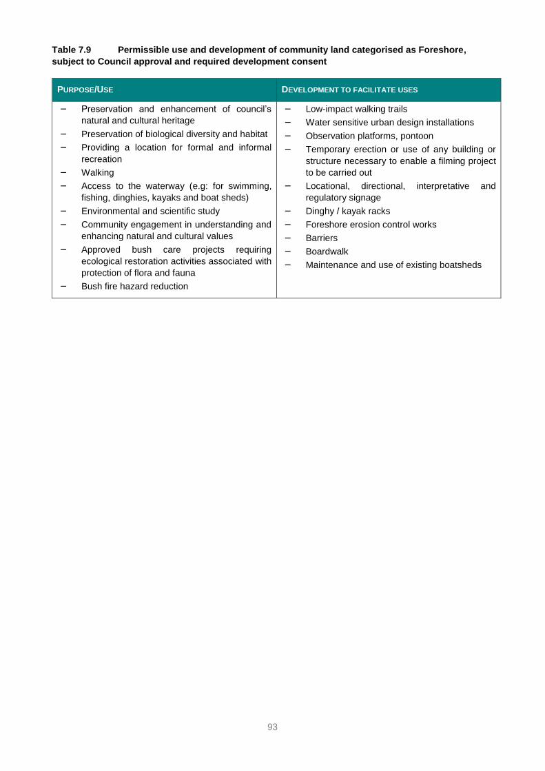
93
Table 7.9 Permissible use and development of community land categorised as Foreshore,
subject to Council approval and required development consent
PURPOSE/USE DEVELOPMENT TO FACILITATE USES
– Preservation and enhancement of council’s
natural and cultural heritage
– Preservation of biological diversity and habitat
– Providing a location for formal and informal
recreation
– Walking
– Access to the waterway (e.g: for swimming,
fishing, dinghies, kayaks and boat sheds)
– Environmental and scientific study
– Community engagement in understanding and
enhancing natural and cultural values
– Approved bush care projects requiring
ecological restoration activities associated with
protection of flora and fauna
– Bush fire hazard reduction
– Low-impact walking trails
– Water sensitive urban design installations
– Observation platforms, pontoon
– Temporary erection or use of any building or
structure necessary to enable a filming project
to be carried out
– Locational, directional, interpretative and
regulatory signage
– Dinghy / kayak racks
– Foreshore erosion control works
– Barriers
– Boardwalk
– Maintenance and use of existing boatsheds

94
APPENDICES
Appendix A – List of Crown reserves covered by this Plan of Management
RESERVE
NUMBER
RESERVE NAME PURPOSE RP IDENTIFIER
(LOTS/DP)
SUBURB COUNCIL ASSIGNED
CATEGORIES
DIRECTED
CATEGORIES
PROPOSED POM CATEGORY
37233 Mornington Reserve Access; Public
Recreation
Lot 7341
DP 1155948
Hunter’s
Hill
General Community
Use; Park
Natural Area Park
Natural Area – Bushland
Natural Area - Foreshore
47916 Murray Prior Reserve Public Baths;
Recreation
Lot 7343
DP 1155920
Hunter’s
Hill
Park Park
Natural Area – Bushland
Natural Area - Foreshore
500262
(PART)
St Johns Park
(Part Boronia Park)
Public
Recreation
Lot 829
DP 752035
Part Lot 7352
DP 1156319
Hunter’s
Hill
Park Natural Area – Bushland
1000442 Wharf Reserve Public Wharf Lot 1
DP 1154490
Hunter’s
Hill
General Community
Use
Natural Area –
Bushland
Natural Area – Bushland
500284 Collingwood St
Reserve
Baths; Boatshed Lot 7339
DP 1162761
Woolwich Park and General
Community Use
Park
Natural Area - Foreshore
500286 Woolwich Baths and
Boatshed
Boatshed; Public
Baths
Lot 7340
DP 1162761
Woolwich Park; General
Community Use
Park Park
87323 Villa Maria Reserve Public
Recreation
Lot 1
DP 909044
Hunter’s
Hill
Park Park
92875 Valencia Street
Reserve (Part: Wharf)
Wharf Site Lot 2
DP 909048
Woolwich General Community
Use
Park
1000434 Valentia Street
Reserve
Wharfage Lot 1
DP 725593
Woolwich General Community
Use
Park Park
1000435 Gale Street Reserve Public Wharf Lot 1
DP 1153661
Woolwich General Community
Use
Park
• Note: Certificate of Titles for three reserves show Hunter's Hill Municipality as the land owner in the Certificate's First Schedule. The three Certificates have a
Second Schedule statement that the reserves are Crown reserves within the meaning of the (repealed) Crown Lands Act 1989, now being the Crown Land
Management Act 2016. These three reserves are, therefore, Crown reserves subject to the CLM Act and included in this PoM: 1000442 Wharf Reserve,
1000434 Valentia Street Reserve, and 1000435 Gale Street Reserve.

95
Appendix B – Mapped location of Crown reserves covered by this plan of management

96

97
Appendix C – Mapped Crown reserves with more than one category on the land

98

99
Top Related