


Languages
Pages
Legal


DEVELOPMENT SERVICES DEPARTMENT Date of Notice: 2/20/2015 PUBLIC NOTICE OF A
DRAFT PROGRAM ENVIRONMENTAL IMPACT REPORT SAP No.: 24002602
__________________________________________________________________________________________ The City of San Diego Development Services Department has prepared a draft Environmental Impact Report (EIR) for the following project and is inviting your comments regarding the adequacy of the document. The draft EIR and associated technical appendices have been placed on the City of San Diego web-site at http://www.sandiego.gov/city-clerk/officialdocs/notices/index.shtml. Your comments must be received by April 7, 2015, to be included in the final document considered by the decision-making authorities. Please send your written comments to the following address: Jeffrey Szymanski, Environmental Planner, City of San Diego Development Services Center, 1222 First Avenue, MS 501, San Diego, CA 92101 or e-mail your comments to [email protected] with the Project Name and Number in the subject line. General Project Information: Project Name: Union Tribune Mixed Use Project Project No. 277550 / SCH No. 2013031032 Community Plan Area: Mission Valley Council District: 6 Subject: VESTING TENTATIVE MAP (VTM), PLANNED DEVELOPMENT PERMIT (PDP), and SITE DEVELOPMENT PERMIT (SDP) to develop a portion of the existing 12.86-acre San Diego Union Tribune (UT) site to add multiple uses including residential, retail, and public space uses. The project site is currently occupied by 168,575 square feet (sf) of office space and 191,600 sf of manufacturing land uses. The proposed project would consist of two new seven-story multi-unit residential buildings featuring 200 total dwelling units for a total of 285,645 sf of gross floor area, four stories of parking featuring 671 parking spaces for a total of 212,069 sf of gross floor area, conversion of 3,000 sf of ground floor area of the existing UT printing facility to retail amenity space, provision of a 23,455 sf public river walk promenade extending along the northern boundary of the project to the Fashion Valley Transit Center, and provision of a 11,947 sf public pocket park adjacent to the proposed river park. Applicant: Mission Valley Holdings, LLC Recommended Finding: The draft EIR concludes that the project would result in significant but mitigated environmental impacts to the following areas Land Use, Biological Resources, Geologic Conditions, Historical Resources (Archaeological), Paleontological Resources, and Noise (Construction) and significant and unmitigated impacts related to: Transportation/Circulation/Parking. Availability in Alternative Format: To request this Notice, the draft EIR, and/or supporting documents in alternative format, call the Development Services Department at 619-446-5460 or (800) 735-2929 (TEXT TELEPHONE). Additional Information: For environmental review information, contact Jeffrey Szymanski at (619) 446-5324. The draft EIR and supporting documents may be reviewed, or purchased for the cost of reproduction, at the Fifth floor of the Development Services Center. If you are interested in obtaining additional copies of either the Compact Disk (CD), or a hard-copy of the draft EIR, they can be purchased for an additional cost. For information regarding public meetings/hearings on this project, contact William Zounes at (619) 687-5942. This notice was published in the SAN DIEGO DAILY TRANSCRIPT and distributed on 2/20/15. Kerry Santoro Interim Deputy Director Development Services Department


Draft Environmental Impact Report (DEIR)for the
Union Tribune Mixed Use ProjectSCH #2013031032 / PTS #277550
Prepared byBRG Consulting, Inc.
Prepared forThe City of San Diego
February 2015
Draft Environmental Impact Report
for the
Union Tribune Mixed Use Project
SCH #2013031032 / PTS #277550
prepared for
City of San Diego
Development Services Department 1222 1st Ave
San Diego, CA 92101
prepared by
BRG Consulting, Inc. 304 Ivy Street
San Diego, CA 92101
February 2015

Table of Contents
Union Tribune Mixed Use Project i February 2015 Draft EIR
Table of Contents Chapter Page No.
ACRONYMS................................................................................................................................................................ A-1
EXECUTIVE SUMMARY...........................................................................................................................................ES-1
1.0 INTRODUCTION ...........................................................................................................................................1-1
1.1 CEQA Requirements .......................................................................................................................1-5
1.2 Purpose and Uses of this EIR .........................................................................................................1-6
1.3 EIR Format ......................................................................................................................................1-7
2.0 ENVIRONMENTAL SETTING .......................................................................................................................2-1
2.1 Location ...........................................................................................................................................2-1
2.2 Physical Characteristics ..................................................................................................................2-1
2.3 Surrounding Land Uses...................................................................................................................2-1
2.4 Applicable Land Use Plans..............................................................................................................2-2
2.5 Emergency Services........................................................................................................................2-4
3.0 PROJECT DESCRIPTION.............................................................................................................................3-1
3.1 Project Background and Objectives ................................................................................................3-1
3.2 Project Characteristics.....................................................................................................................3-2
3.3 Discretionary Actions.....................................................................................................................3-10
4.0 HISTORY OF PROJECT CHANGES ............................................................................................................4-1
5.0 ENVIRONMENTAL ANALYSIS ..................................................................................................................5.1-1
5.1 Land Use ......................................................................................................................................5.1-1
5.2 Traffic/Circulation/Parking ............................................................................................................5.2-1
5.3 Greenhouse Gas Emissions.........................................................................................................5.3-1
5.4 Biological Resources ....................................................................................................................5.4-1
5.5 Geologic Conditions .....................................................................................................................5.5-1
5.6 Historical Resources.....................................................................................................................5.6-1
5.7 Hydrology .....................................................................................................................................5.7-1
5.8 Public Services and Facilities .......................................................................................................5.8-1
5.9 Public Utilities ...............................................................................................................................5.9-1
5.10 Visual Effects/Neighborhood Character .....................................................................................5.10-1
5.11 Water Quality..............................................................................................................................5.11-1
5.12 Paleontology...............................................................................................................................5.12-1
5.13 Air Quality ...................................................................................................................................5.13-1
5.14 Noise ..........................................................................................................................................5.14-1
6.0 CUMULATIVE IMPACTS...............................................................................................................................6-1
6.1 Cumulative Projects.........................................................................................................................6-1
6.2 Cumulative Impacts Found to Be Significant...................................................................................6-2

Table of Contents
Union Tribune Mixed Use Project ii February 2015 Draft EIR
Table of Contents Chapter Page No. 7.0 EFFECTS NOT FOUND TO BE SIGNIFICANT.............................................................................................7-1
7.1 Agricultural Resources ....................................................................................................................7-1
7.2 Health and Safety and Hazardous Materials ...................................................................................7-1
7.3 Historical Resources (Built Environment) ........................................................................................7-2
7.4 Mineral Resources...........................................................................................................................7-2
7.5 Population and Housing ..................................................................................................................7-2
8.0 MANDATORY DISCUSSION AREAS ...........................................................................................................8-1
8.1 Significant Environmental Effects Which Cannot Be Avoided.........................................................8-1
8.2 Significant Irreversible Environmental Changes..............................................................................8-1
8.3 Growth Inducing Impacts.................................................................................................................8-2
9.0 ALTERNATIVES............................................................................................................................................9-1
9.1 Rationale for Alternative Selection ..................................................................................................9-1
9.2 Alternatives Considered But Rejected.............................................................................................9-3
9.3 Alternatives Considered ..................................................................................................................9-5
10.0 MITIGATION MONITORING AND REPORTING PROGRAM.....................................................................10-1
11.0 REFERENCES ............................................................................................................................................11-1
12.0 CERTIFICATION PAGE ..............................................................................................................................12-1
List of Figures
Figure No. Page No. 1-1 Regional Location ..........................................................................................................................................1-2
1-2 Local Vicinity ..................................................................................................................................................1-3
1-3 Aerial Map of the Project Site ........................................................................................................................1-4
3-1 Project Site Plan ............................................................................................................................................3-5
3-2 Park Plan .......................................................................................................................................................3-7
3-3 Public Pocket Park Plan.................................................................................................................................3-9
3-4 Landscape Plan ...........................................................................................................................................3-11
3-5 Retaining Walls ............................................................................................................................................3-13
5.1-1 Existing Land Use.......................................................................................................................................5.1-2
5.1-2 Mission Valley Community Planning Area ..................................................................................................5.1-3
5.1-3 Multi-Habitat Planning Area ........................................................................................................................5.1-5
5.1-4 FEMA Special Flood Hazard Areas ............................................................................................................5.1-8
5.1-5 Zoning .........................................................................................................................................................5.1-9
5.1-6 Montgomery Field Airport Influence Area .................................................................................................5.1-40
5.2-1 Existing Conditions .....................................................................................................................................5.2-3
5.2-2 Existing Traffic Volumes .............................................................................................................................5.2-4

Table of Contents
Union Tribune Mixed Use Project iii February 2015 Draft EIR
Table of Contents List of Figures
Figure No. Page No. 5.2-3 Project Traffic Volumes.............................................................................................................................5.2-15
5.2-4 Existing With Project Traffic Volumes.......................................................................................................5.2-16
5.2-5 Near-Term (Opening Day 2017) Project Traffic Distribution .....................................................................5.2-20
5.2-6 Near-Term (Opening Day 2017) Project Traffic Volumes.........................................................................5.2-21
5.2-7 Near-Term (Opening Day 2017) With Project Traffic Volumes.................................................................5.2-22
5.2-8 Existing + Project Impacts & Mitigation Measures....................................................................................5.2-27
5.2-9 Near-Term (Year 2017) Impacts and Mitigation Measures.......................................................................5.2-36
5.2-10 Development Intensity Districts.................................................................................................................5.2-42
5.4-1 Biological Resources ..................................................................................................................................5.4-3
5.7-1 Existing Drainage Area ...............................................................................................................................5.7-3
5.7-2 Proposed Drainage Area ............................................................................................................................5.7-7
5.10-1 Photo Viewpoints ......................................................................................................................................5.10-2
5.10-2 Existing Conditions (Photos 1-2)...............................................................................................................5.10-3
5.10-3 Existing Conditions (Photos 3-4)...............................................................................................................5.10-4
5.10-4 Existing Conditions (Photo 5)....................................................................................................................5.10-5
5.10-5 Architectural Rendering 1-2 ....................................................................................................................5.10-10
5.10-6 Architectural Rendering 3-4 ....................................................................................................................5.10-11
5.10-7 Architectural Rendering 5 .......................................................................................................................5.10-12
5.10-8 Public Viewpoints....................................................................................................................................5.10-13
5.10-9 Existing Photo Settings (VP6, VP7, VP8) ...............................................................................................5.10-14
5.10-10 Existing Photo Settings (VP9, VP10) ......................................................................................................5.10-15
5.10-11 Existing and Proposed Views (VP6) .......................................................................................................5.10-16
5.10-12 Existing and Proposed Views (VP10) ....................................................................................................5.10-17
5.11-1 Water Quality Plan and Detail...................................................................................................................5.11-5
6-1 Cumulative Projects .......................................................................................................................................6-3
6-2 Near-Term Cumulative Project Assignments.................................................................................................6-5
6-3 Year 2035 Planned Improvements (Roadway Segments).............................................................................6-9
6-4 Year 2035 Planned Improvements (Intersections).......................................................................................6-10
6-5 Year 2035 Without Project Traffic Volumes.................................................................................................6-11
6-6 Year 2035 With Project Traffic Volumes......................................................................................................6-12
6-7 Horizon Year Street Segment Mitigation Analysis .......................................................................................6-19
9-1 Reduced Density to Avoid Traffic Impacts Alternative (55 Dwelling Units) – Conceptual Site Plan ..............9-9
9-2 Reduced Density to Avoid Traffic Impacts Alternative (55 Dwelling Units) – Ground Level ........................9-11
9-3 Reduced Residential Density Alternative (135 Dwelling Units) – Conceptual Site Plan..............................9-17
9-4 Reduced Residential Density Alternative (135 Dwelling Units) – Ground Level ..........................................9-19

Table of Contents
Union Tribune Mixed Use Project iv February 2015 Draft EIR
Table of Contents List of Tables
Table No. Page No. ES-1 Summary of Environmental Impacts and Mitigation Measures...................................................................ES-8
5.1-1 General Plan Consistency Analysis ..........................................................................................................5.1-11
5.1-2 Mission Valley Community Plan Consistency Analysis.............................................................................5.1-19
5.1-3 City of San Diego MSCP Subarea Plan Consistency Analysis.................................................................5.1-24
5.1-4 San Diego River Park Master Plan General Recommendations Consistency Analysis ...........................5.1-32
5.1-5 San Diego River Park Master Plan Specific Recommendations Consistency Analysis............................5.1-33
5.2-1 Existing Traffic Volumes .............................................................................................................................5.2-5
5.2-2 Existing Intersection Operations .................................................................................................................5.2-6
5.2-3 Existing Street Segment Operations...........................................................................................................5.2-7
5.2-4 Existing Freeway Segment Operations.......................................................................................................5.2-8
5.2-5 Caltrans District 11 Freeway Segment Level of Service Definitions.........................................................5.2-11
5.2-6 City of San Diego Traffic Impact Significant Thresholds...........................................................................5.2-12
5.2-7 Union Tribune Master Plan Trip Generation (Standard City Method) .......................................................5.2-14
5.2-8 Existing + Project Intersection Operations................................................................................................5.2-18
5.2-9 Existing + Project Street Segment Operations .........................................................................................5.2-19
5.2-10 Opening Day Intersection Operations.......................................................................................................5.2-23
5.2-11 Opening Day Street Segment Operations ................................................................................................5.2-24
5.2-12 Existing + Project Significant Impacts.......................................................................................................5.2-25
5.2.13 Near-Term (Opening Day 2017) Significant Impacts ................................................................................5.2-25
5.2-14 Existing + Project Intersection Mitigation Analysis....................................................................................5.2-29
5.2-15 Existing + Project Street Segment Mitigation Analysis .............................................................................5.2-30
5.2-16 Near-Term Intersection Mitigation Analysis ..............................................................................................5.2-31
5.2-17 TDM Summary Table................................................................................................................................5.2-31
5.2-18 Near-Term (Opening Day 2017) Intersection Mitigation Analysis.............................................................5.2-34
5.2-19 Near-Term (Opening Day 2017) Street Segment Mitigation Analysis ......................................................5.2-35
5.2-20 Trip Generation Per Municipal Code.........................................................................................................5.2-41
5.2-21 Threshold Calculations .............................................................................................................................5.2-41
5.2-22a Existing + Project Freeway Segment Operations – AM Peak Hour..........................................................5.2-45
5.2-22b Existing + Project Freeway Segment Operations – PM Peak Hour..........................................................5.2-46
5.2-23a Near-Term (Opening Day 2017) Freeway Segment Operations – AM Peak Hour ...................................5.2-47
5.2-23b Near-Term (Opening Day 2017) Freeway Segment Operations – PM Peak Hour ...................................5.2-48
5.2-24 Parking Requirements ..............................................................................................................................5.2-49
5.2-25 Parking Summary .....................................................................................................................................5.2-50
5.3-1 Year 2020 Total GHG Emissions over BAU .............................................................................................5.3-10
5.4-1 Permanent Direct Impacts of the Project ....................................................................................................5.4-6
5.4-2 Bioswale and Detention Basin Plant Palette...............................................................................................5.4-8
5.5-1 Deterministic Max. Earthquake Magnitude and Peak Ground Acceleration Within the Region..................5.5-3
5.5-2 Probabilistic Seismic Hazard Parameters...................................................................................................5.5-3

Table of Contents
Union Tribune Mixed Use Project v February 2015 Draft EIR
Table of Contents List of Tables
Table No. Page No. 5.5-3 Expansion Classification Based on Expansion Index .................................................................................5.5-5
5.7-1 Existing Drainage Basin Conditions............................................................................................................5.7-2
5.7-2 Proposed Drainage Basin Conditions .........................................................................................................5.7-5
5.8-1 Western Division Call Priority Response Times..........................................................................................5.8-2
5.8-2 Responding Vehicles and Response Times ...............................................................................................5.8-3
5.8-3 North Central Region Parks and Open Space............................................................................................5.8-4
5.8-4 School Capacity and Student Generation...................................................................................................5.8-4
5.9-1 Projected Demands for proposed Project ...................................................................................................5.9-4
5.9-2 Estimated Demolition Quantifies and Tons Diverted ..................................................................................5.9-8
5.9-3 Estimated Construction Waste..................................................................................................................5.9-10
5.9-4 Waste Generation – Occupancy Waste....................................................................................................5.9-12
5.9-5 Min. Exterior Refuse and Recyclable Material Storage Areas for Residential Development....................5.9-12
5.9-6 Min. Exterior Refuse and Recyclable Material Storage Areas for Residential Development....................5.9-12
5.10-1 General Plan Consistency Analysis ........................................................................................................5.10-21
5.10-2 Mission Valley Community Plan Consistency Analysis...........................................................................5.10-23
5.10-3 City of San Diego MSCP Subarea Plan Consistency Analysis...............................................................5.10-27
5.10-4 San Diego River Park Master Plan Consistency Analysis ......................................................................5.10-27
5.13-1 Federal and State Ambient Air Quality Standards ....................................................................................5.13-2
5.13-2 San Diego County Air Pollutant Attainment Status ...................................................................................5.13-3
5.13-3 Ambient Air Quality Data...........................................................................................................................5.13-4
5.13-4 SDAPCD Thresholds of Significance for Air Quality Impacts ...................................................................5.13-6
5.13-5 Estimated Maximum Annual Construction Emissions (lbs/day)................................................................5.13-7
5.13-6 Estimated Operational Emissions (lbs/day) ..............................................................................................5.13-8
5.14-1 City of San Diego Land Use Noise Compatibility Guidelines....................................................................5.14-3
5.14-2 City of San Diego Traffic Noise Significance Thresholds..........................................................................5.14-4
6-1 Cumulative Projects (Opening Day)...............................................................................................................6-1
6-2 Cumulative Projects (Horizon Year)...............................................................................................................6-2
6-3 Horizon Year Intersection Operations............................................................................................................6-7
6-4 Horizon Year Street Segment Operations ...................................................................................................6-13
6-5a Horizon Year Freeway Segment Operations – AM Peak Hour....................................................................6-14
6-5b Horizon Year Freeway Segment Operations – PM Peak Hour....................................................................6-14
6-6 Horizon Year Significant Impacts.................................................................................................................6-15
6-7 Horizon Year Intersection Segment Mitigation Analysis ..............................................................................6-16
6-8 Horizon Year Street Segment Mitigation Analysis .......................................................................................6-17
9-1 Comparison of Project Alternatives................................................................................................................9-2

Table of Contents
Union Tribune Mixed Use Project vi February 2015 Draft EIR
List of Technical Appendices (Bound with Draft EIR)
Appendix A: Notice of Preparation and Comment Letters
(Provided on CD)
Appendix B: Traffic Impact Analysis Prepared by Linscott, Law & Greenspan, Engineers
February 12, 2015
Appendix C: Greenhouse Gas Assessment Prepared by Ldn Consulting, Inc.
October 6, 2014
Appendix D: Biological Resources Report Prepared by Rocks Biological Consulting
January 26, 2015
Appendix E1: Geologic Reconnaissance Prepared by Geocon Incorporated
April 24, 2012
Appendix E2: Response to City Comments Prepared by Geocon Incorporated
November 13, 2013
Appendix E3: Update Geotechnical Letter Prepared by Geocon Incorporated
September 3, 2014
Appendix E4: Response to City Comments Prepared by Geocon Incorporated
November 26, 2014
Appendix F1: Preliminary Drainage Study Prepared by Latitude 33 Planning & Engineering
December 12, 2013
Appendix F2: Addendum to the Preliminary Drainage Study Prepared by Latitude 33 Planning & Engineering
December 2014

Table of Contents
Union Tribune Mixed Use Project vii February 2015 Draft EIR
Appendix G1: Water Quality Technical Report Prepared by Latitude 33 Planning & Engineering
April 2014
Appendix G2: Addendum to the Water Quality Technical Report Prepared by Latitude 33 Planning & Engineering
December 2014
Appendix H1: Preliminary Sewer Study Prepared by Latitude 33 Planning & Engineering
February 19, 2014
Appendix H2: Sewer Study Addendum Prepared by Latitude 33 Planning & Engineering
October 14, 2014
Appendix I: Waste Management Plan Update Prepared by Latitude 33 Planning & Engineering
October 2014
Appendix J: Water Supply Assessment Requirement Analysis Prepared by Latitude 33 Planning & Engineering
December 30, 2014
Appendix K: Traffic Sensitivity Analysis Prepared by Linscott, Law & Greenspan, Engineers
January 2015
Appendix L: Collocation/Conversion Suitability Factors Analysis Prepared by BRG Consulting, Inc.
January 26, 2015

Table of Contents
Union Tribune Mixed Use Project viii February 2015 Draft EIR
This page intentionally left blank.

Acronyms
Union Tribune Mixed Use Project A-1 February 2015 Draft EIR
ACRONYMS
AB Assembly Bill
ADD Assistant Deputy Director
ADT Average Daily Trips
AF acre-feet
AIA Airport Influence Area
ALUC Airport Land Use Committee
ALUCP Airport Land Use Compatibility Plan
amsl above mean sea level
ARB Air Resources Board
BAU business as usual
BD/BA bedroom/bath
BFE Base Flood Elevation
BMP Best Management Practice
B.P. before present
CalEPA California Environmental Protection Agency
CAPCOA California Air Pollution Control Officers Association
CARB California Air Resources Board
CAT Climate Action Team
CBC California Building Code
CCTP Climate Change Technology Program
CDFW California Department of Fish and Wildlife
CEQA California Environmental Quality Act
cfs cubic feet per second
CGS California Geological Survey
CH4 methane
CLOMR Conditional Letter of Map Revision
CNDDB California Natural Diversity Database
CNEL Community Noise Level Equivalent
CNPS California Native Plant Society
CO carbon monoxide
CO2 carbon dioxide
CO2e carbon dioxide equivalent
CPA Community Plan Amendment
CWA Clean Water Act
DEV developed/urban land
DIF Developer Impact Facilities
DMG Division of Mines and Geology
EIR Environmental Impact Report
EO Executive Order
EPA Environmental Protection Agency

Acronyms
Union Tribune Mixed Use Project A-2 February 2015 Draft EIR
ESD Environmental Services Department
ESL Environmentally Sensitive Lands
EUC Eucalyptus Woodland
FAA Federal Aviation Administration
FAR Federal Aviation Regulations
FBA Facility Benefit Assessment
FCAA Federal Clean Air Act
FEMA Federal Emergency Management Agency
FIRM Flood Insurance Rate Map
fps feet per second
FU fixture units
GCF Green Climate Fund
GHG Greenhouse Gas
GIS Geographic Information System
gpd gallons per day
GWP Global Warming Potential
HA Hydrologic Area
HFC hydrofluorocarbon
HSA Hydrologic Subarea
I-8 Interstate-8
IOD Irrevocable Offer of Dedication
KWh Kilowatt hours
LCFS Low Carbon Fuel Standard
LDC Land Development Code
LID Low-Impact Design
LOS Level of Service
MBTA Migratory Bird Treaty Act
MGD million gallons per day
MHPA Multi-Habitat Planning Area
MLD Most Likely Descendent
MM mitigation measure
mmBTU million British Thermal Units
MMC Mitigation Monitoring Coordination
MPO Metropolitan Planning Organization
MSCP Multiple Species Conservation Program
MSL Mean Sea Level
MTCO2E metric tons carbon dioxide equivalent
MTS Metropolitan Transit System
MVPD Mission Valley Planned District
MXD Mixed-Use Development
N2O nitrous oxide
NAHC Native American Heritage Commission
NNG Non-Native Grassland

Acronyms
Union Tribune Mixed Use Project A-3 February 2015 Draft EIR
NOP Notice of Preparation
NTP Notice to Proceed
ORN Ornamental
PDP Planned Development Permit
PDWF Peak Dry Weather Flow
PFC perfluorocarbon
ppm parts per million
PUD Public Utilities Department
RBC Rocks Biological Consulting
RHNA Regional Housing Needs Assessment
RTP Regional Transportation Plan
RWQCB Regional Water Quality Control Board
SANDAG San Diego Association of Governments
SB Senate Bill
SCAQMD South Coast Air Quality Management District
SCS Sustainable Communities Strategy
SDG&E San Diego Gas & Electric
SDIA San Diego International Airport
SDP Site Development Permit
SDRWQCB San Diego Regional Water Quality Control Board
SDSU San Diego State University
SDUSD San Diego Unified School District
sf square feet
SF6 sulfur hexafluoride
SFHA Special Flood Hazard Area
SHMA Seismic Hazards Mapping Act
SR-163 State Route 163
SWMC Solid Waste Management Coordinator
SWPPP Storm Water Pollution Prevention Plan
Tc time of concentration
TDM Transportation Demand Management
TMDL Total Maximum Daily Load
TOD Transit Oriented Development
TRIMMS Trip Reduction Impacts for Mobility Management Strategies
UBC Uniform Building Code
UNFCCC United Nations Framework Convention on Climate Change
USFWS United States Fish and Wildlife Service
USGS United States Geological Survey
UT Union Tribune
VTM Vesting Tentative Map
WMC Waste Management Coordinator
WMP Waste Management Plan

Acronyms
Union Tribune Mixed Use Project A-4 February 2015 Draft EIR
This page intentionally left blank.

Executive Summary
Union Tribune Mixed Use Project ES-1 February 2015 Draft EIR
EXECUTIVE SUMMARY
ES.1 Project Description The San Diego Union Tribune and Manchester Financial Group propose to develop a portion of the existing 12.86-
acre San Diego Union Tribune site at 350 Camino De La Reina to add multiple uses including residential, retail, and
public space uses to the project site. When combined with the existing office and manufacturing uses on the site, the
proposed project will create a pedestrian-friendly, transit-oriented, mixed-use project. Specifically, the proposed
project will include the construction of the following:
• New seven-story multi-unit residential buildings featuring 200 dwelling units for a total of 285,645 square feet
of gross floor area;
• Four-stories of parking featuring 671 parking spaces for a total of 212,069 square feet of gross floor area, to
be located on a below-grade level and the first three levels of one the residential buildings (Northwest
Building);
• Conversion of 3,000 square feet of ground floor area of the existing UT printing building to retail amenity
space; and,
• Implementation of the San Diego River Park Master Plan along the northern boundary of the project,
including an extension of the San Diego River Park trail from the Town and Country Resort property to the
west and the provision of a public pocket park adjacent to the River Park area, which would include
approximately 35,402 square feet (River Park is 23,455 square feet and public pocket park is 11,947 square
feet).
ES.2 Project Location and Setting The project site is centrally located in the City of San Diego (City), within the Mission Valley Community Planning
Area (see Figure 1-1, Regional Map). The Mission Valley Community Planning Area is comprised of approximately
2,418 net acres and is bound on the west by Interstate 5 (I-5), on the north by Friars Road west of State Route 163
(SR-163) and by the northern slopes of valley east of SR-163, on the east by the eastern back of the San Diego
River, and on the south by the southern slopes of the valley. More specifically, the project site is located at the
northwest corner of Interstate 8 (I-8) and SR-163, at 350 Camino De La Reina, San Diego, California, 92108. The
project site comprises of Lot 2 of Map No. 6860 (APN 437-260-41). The project site fronts Camino De La Reina to the
south and east, and is bounded by the San Diego River to the north, and the Town and Country Hotel to the west.
The project site is approximately two miles northeast of San Diego International Airport and three miles southwest of
Montgomery Field.
ES.3 Project Objectives
In accordance with CEQA Guidelines Section 15124, the following objectives describe the underlying purpose of the
project, assist the Lead Agency in developing reasonable range of alternatives to be evaluated in the EIR, and
ultimately aid decision-makers in preparing findings and overriding considerations, if necessary.
• To provide a portion of the housing needs within the community;

Executive Summary
Union Tribune Mixed Use Project ES-2 February 2015 Draft EIR
• To provide a new public park amenity for the community;
• To provide a San Diego River Pathway;
• To provide a mixed-use Transit-Oriented Development (TOD) to accommodate the increasing growth in the
region;
• To provide multiple land uses as in-fill development of an underutilized site within an urban area in close
proximity to existing public transit;
• To provide connections to existing public transit;
• To provide additional parking for current and future employees and residents;
• To provide a residential development that reasonably maximizes the number of residential units on the
project site without exceeding the Mission Valley Planned District Ordinance Threshold 2 for Traffic District
C of 417 ADT per acre and subsequently not requiring the need for a Community Plan Amendment;
• To reasonably maximize the efficiency in use of the developable land on the site;
• To provide a project that is consistent with the City of Villages and Smart Growth policies, maximize
residential development at an infill site, where public facilities, transit, and services are within walking
distance; and,
• To provide development that is compatible in density, scale, and character with the other development within
the Mission Valley community; and,
• To provide a development that is consistent with the goals and policies of the City of San Diego General
Plan, City of Villages Strategy and Mission Valley Community Plan, which promote the development of
multiple use projects that encourage the use of alternative modes of transportation and reduces vehicle
miles traveled per capita.
ES.4 Summary of Significant Effects and Mitigation Measures that Reduce or Avoid the Significant Effects
Table ES-1, located at the end of this section, summarizes the results of the environmental analysis completed for
each issue area for the proposed project. Table ES-1 also includes mitigation measures to reduce and/or avoid the
environmental effects, with a conclusion as to whether the impact has been mitigated to below a level of significance.
The mitigation measures listed in Table ES-1 are also discussed accordingly within each environmental issue area.
Based on the analysis and conclusions of the EIR, implementation of the proposed project would result in significant
and unavoidable traffic/circulation impacts. In addition, the proposed project would result in potentially significant but
mitigable impacts to the following issue areas: land use, biological resources, geologic conditions, historical
resources, paleontological resources, and noise. The project’s impacts for all other issue areas were determined to
be less than significant or no impact was identified.

Executive Summary
Union Tribune Mixed Use Project ES-3 February 2015 Draft EIR
ES.5 Areas of Controversy Section 15123(b)(2) of the CEQA Guidelines requires that areas of controversy known to the Lead Agency, including
issues raised by agencies and the public, be identified in the Summary chapter of the EIR. To determine the number,
scope and extent of the environmental topics to be addressed in this Draft EIR, the City prepared a Notice of
Preparation (NOP) and circulated the NOP to interested public agencies, organizations, community groups and
individuals in order to receive input on the proposed project. The NOP was distributed on March 13, 2013 for a 30-
day public review and comment period, and a public scoping meeting was held on March 27, 2013. Public comments
received on the NOP, and comments from the scoping meeting reflect controversy related to environmental issues to
be discussed in the EIR.
Issues raised in response to the Notice of Preparation prepared and circulated for this Draft EIR focus around
traffic/circulation and biological resource adjacency issues. The biological resource adjacency issues were raised
through written comments from the California Department of Fish and Wildlife and the San Diego Audubon Society.
In addition to written comments received, the City of San Diego held a public scoping meeting where verbal
comments were provided in regards to biological resources and traffic/circulation issues.
ES.6 Issues to be Resolved by the Decision-Making Body
As discussed in detail in Section 5.2 of this EIR, both direct and cumulative impacts to traffic/circulation would be
significant and unavoidable. The City of San Diego Planning Commission must review the project and determine if
the proposed project, or one of the alternatives presented in Section 9.0, or some combination of the project
components, should be adopted and implemented. If the proposed project is selected for adoption, the Council will be
required to certify the Final EIR, determine whether and how to mitigate significant impacts and adopt associated
Findings (CEQA Guidelines Section 15091) for all significant impacts within the EIR. Furthermore, a Statement of
Overriding Considerations pursuant to CEQA Guidelines Section 15093 would be required for those impacts found to
be significant and unavoidable, including the direct and cumulative impacts associated with traffic/circulation.
In addition, the proposed project is requesting the following deviation from allowable requirements:
• Four (4) 8-foot-tall retaining walls and three (3) 7-foot-tall retaining walls, where 6 feet is allowed.
ES.7 Project Alternatives
In order to fully evaluate the environmental effects of proposed projects, CEQA mandates that alternatives to the
proposed project be analyzed. Section 15126.6 of the CEQA Guidelines requires the discussion of “a range of
reasonable alternatives to the project, or to the location of the project, which would feasibly attain most of the basic
objectives of the project but would avoid or substantially lessen any of the significant effects of the project” even if the
alternatives would impede the attainment of the project objectives to some degree. As discussed in Section 9.0
Alternatives of this EIR, the following alternatives were considered but rejected:
• Alternative Site Location
• Previously Proposed Union Tribune Mixed-Use Alternative
• Office Only Alternative

Executive Summary
Union Tribune Mixed Use Project ES-4 February 2015 Draft EIR
The following alternatives were considered and analyzed in detail in Chapter 9.0 Alternatives of this EIR:
1. No Project (No Development) Alternative The No Project (No Development) Alternative would retain the site in its current condition, including the existing one-
story automotive service center, five-story commercial office building, three-story printing facility, and surface parking
lot. No new development, including the proposed 3.5 story parking structure, new residential buildings with 200-units
on top of four-stories of parking, 3,000 square feet of retail space, or 13 new townhomes, would occur.
When compared to the proposed project, the No Project (No Development) Alternative would avoid the unavoidable
traffic/circulation/parking impacts. The No Project (No Development) Alternative would result in greater
environmental effects associated with water quality and hydrology, because this alternative would not implement
BMPs and would have greater impervious surfaces as compared to the proposed project. However, the No Project
(No Development) Alternative would avoid impacts for all other issue areas. However, the No Project (No
Development) Alternative would not meet any of the objectives of the project as identified in Chapter 3.0 of this EIR,
and is, therefore, not recommended for selection and implementation.
2. Reduced Density Alternatives In order to fully evaluate the range of possible alternatives that would avoid or reduce the impacts associated with the
proposed project, a traffic sensitivity analysis was performed by Linscott Law and Greenspan (LLG) dated January
2015 and provided as Appendix K of this EIR. It addressed the critical street segments surrounding the project site to
determine the land use intensity/level of development at which traffic/circulation related impacts would be reduced to
a less than significant level per the City’s traffic thresholds. The traffic sensitivity analysis was conducted for street
segments only given that they are the “constrained” facility within the study area. If the alternative were to avoid
significant street segment impacts, intersection impacts would also be avoided given the low trip generation. Based
on the results of the analysis, it was determined that a new development consisting of 55 residential units could be
built (in addition to the existing UT complex) which would reduce all of the traffic/circulation/parking impacts that were
identified in this EIR with the implementation of the proposed project to a less than significant level.
Any project proposed on the project site consisting of a development greater than 55 residential units would generate
a number of daily trips which would exceed the City’s thresholds and trigger significant roadway segment impacts
both in the Near-Term (Opening Day 2017) and Year 2035 (Horizon Year). Any project alternative proposing between
55 and 200 residential units would still result in significant and unavoidable impacts to traffic per the City’s CEQA
thresholds. As such two density alternatives were identified and analyzed in this EIR, the 55 residential units
alternative that would avoid the traffic impacts and another alternative consisting of 135 residential units, which is a
density between 55 units and 200 units proposed under the proposed project. The following provides the analysis for
these two alternatives.
Reduced Residential Density to Avoid Traffic Impacts Alternative (55 DU)
The Reduced Residential Density to Avoid Traffic Impacts Alternative will include the construction of the following:
• New two-story multi-unit residential buildings featuring 55 dwelling units for a total of approximately 66,211
square feet of general floor area;
Executive Summary
Union Tribune Mixed Use Project ES-5 February 2015 Draft EIR
• Parking lot featuring approximately 173 parking spaces located at grade of the residential buildings
(Northwest Building);
• Conversion of 3,000 square feet of ground floor area of the existing UT printing building to retail commercial
use; and,
• Implementation of the San Diego River Park Master Plan along the north boundary of the project, including
an extension of the San Diego River Park trail from the Town and Country Resort property to the west, and
the provision of a public pocket park adjacent to the River Park area, which would include approximately
35,402 square feet (River Park is 23,455 square feet and public pocket park is 11,947 square feet).
Figures 9-1 and 9-2 provide a conceptual site plan and depict the ground floor level, respectively, of the Reduced
Density to Avoid Traffic Impacts Alternative.
When compared to the proposed project, the Reduced Residential Density to Avoid Traffic Impacts Alternative would
avoid the unavoidable traffic/circulation/parking impacts. The Reduced Residential Density to Avoid Traffic Impacts
Alternative would result in similar impacts for all other issue areas; however, as some issue areas will be slightly
reduced due to the reduction in residential units (i.e., air quality, noise, public utilities, and public services and
facilities).
One of the primary objectives of the proposed project is to develop a mixed-use, TOD. As discussed above, the
Reduced Density to Avoid Traffic Impacts Alternative would allow for a new development consisting of only 55
residential units on a project site that is suited for TOD, which when combined with the existing uses would create a
site with multiple land uses on a site within close proximity to public transit. While at a greatly reduced development
intensity, this alternative would still provide a mixed-use TOD that could accommodate the increasing growth in the
region by providing a portion of the housing needs within the community. In addition, this alternative would still
provide connections to existing public transit located adjacent to the project site. As such, this alternative would still
meet some of the objectives of the proposed project.
The Reduced Density to Avoid Traffic Impacts Alternative would be in conformance with some of the objectives of the
Mission Valley Community Plan, which promotes development intensities related to the planned transportation
network, designated activity centers and river-related open spaces and encourages mixed-use complexes which offer
environments for living, working, shopping and related activities (City of San Diego, 2013). Although this alternative
provides minimal retail, the site’s proximity to Fashion Valley Mall would still offer future residents an environment for
living, working and shopping. In addition, this alternative would generally be in conformance with the City of Villages
Strategy outlined in the City of San Diego General Plan, which promotes mixed-use villages throughout the City
connected by high-quality transit (City of San Diego, 2008). While this alternative would not be considered a mixed-
use village, it would still be a mixed-use development in close proximity to Fashion Valley Mall and adjacent to public
transit.
This alternative would meet most of the project objectives. However, this alternative would not meet the following
objectives at the same level as the proposed project because of the reduction in residential units proposed under this
alternative:
Executive Summary
Union Tribune Mixed Use Project ES-6 February 2015 Draft EIR
• To provide a residential development that reasonably maximizes the number of residential units on the
project site without exceeding the Mission Valley Planned District Ordinance Threshold 2 for Traffic District
C of 417 ADT per acre and subsequently not requiring the need for a Community Plan Amendment;
• To reasonably maximize the efficiency in use of the developable land on this TOD suited site; and,
• To provide a project that is consistent with the City of Villages and Smart Growth policies, maximize
residential development at an infill site, where public facilities, transit, and services are within walking
distance.
Reduced Residential Density Alternative (135 DU)
The Reduced Residential Density Alternative (135 DU) will include the construction of the following:
• New four-story multi-unit residential buildings featuring 135 DU for a total of approximately 175,547 square
feet of general floor area;
• Two-story parking structure featuring approximately 383 parking spaces located at grade and above grade
of the residential buildings (Northwest Building);
• Conversion of 3,000 square feet of ground floor area of the existing UT printing building to retail commercial
use; and,
• Implementation of the San Diego River Park Master Plan along the north boundary of the project, including
an extension of the San Diego River Park trail from the Town and Country Resort property to the west, and
the provision of a public pocket park adjacent to the River Park area, which would include approximately
35,402 square feet (River Park is 23,455 square feet and public pocket park is 11,947 square feet).
Figures 9-3 and 9-4 provide a conceptual site plan and depict the ground floor level, respectively, of the Reduced
Residential Density Alternative (135 DU).
When compared to the proposed project, the Reduced Residential Density Alternative (135 DU) would result in
similar unavoidable traffic impacts as compared to the proposed project with the exception of the avoidance of a
direct impact at the street segment of Hotel Circle N. from Fashion Valley Road to Camino De La Reina. The
Reduced Residential Density Alternative (135 DU) would result in similar impacts for all other issue areas; however,
as some issue areas will be slightly reduced due to the reduction in residential units (i.e., air quality, noise, public
utilities, and public services and facilities).
One of the primary objectives of the proposed project is to develop a mixed-use, TOD. As discussed above, the
Reduced Residential Density Alternative (135 DU) would allow for a new development consisting of 135 residential
units on a project site that is suited for TOD, which when combined with the existing uses would create a site with
multiple land uses on a site within close proximity to public transit. While at a reduced development intensity, this
alternative would still provide a mixed-use TOD that could accommodate the increasing growth in the region by
providing a portion of the housing needs within the community. In addition, this alternative would still provide
connections to existing public transit located adjacent to the project site. As such, this alternative would still meet
some of the objectives of the proposed project.

Executive Summary
Union Tribune Mixed Use Project ES-7 February 2015 Draft EIR
The Reduced Residential Density Alternative (135 DU) would be in conformance with some of the objectives of the
Mission Valley Community Plan, which promotes development intensities related to the planned transportation
network, designated activity centers and river-related open spaces and encourages mixed-use complexes which offer
environments for living, working, shopping and related activities (City of San Diego, 2013). Although this alternative
provides minimal retail, the sites proximity to Fashion Valley Mall would still offer future residents an environment for
living, working and shopping. In addition, this alternative would generally be in conformance with the City of Villages
Strategy outlined in the City of San Diego General Plan, which promotes mixed-use villages throughout the City
connected by high-quality transit (City of San Diego, 2008). While this alternative would not be considered a mixed-
use village, it would still be a mixed-use development in close proximity to Fashion Valley Mall and adjacent to public
transit.
This alternative would meet most of the project objectives. However, this alternative would not meet the following
objectives at the same level as the proposed project because of the reduction in residential units proposed under this
alternative:
• To provide a residential development that reasonably maximizes the number of residential units on the
project site without exceeding the Mission Valley Planned District Ordinance Threshold 2 for Traffic District
C of 417 ADT per acre and subsequently not requiring the need for a Community Plan Amendment;
• To reasonably maximize the efficiency in use of the developable land on this TOD suited site; and,
• To provide a project that is consistent with the City of Villages and Smart Growth policies, maximize
residential development at an infill site, where public facilities, transit, and services are within walking
distance.

Executive Summary
Union Tribune Mixed Use Project ES-8 February 2015 Draft EIR
Table ES-1 Summary of Environmental Impacts and Mitigation Measures
Environmental Impact Mitigation Measures Significance After Mitigation
Section 5.1 Land Use
Although no significant land use impacts were identified, implementation of Mitigation Measure LU-1 would ensure that no significant land use impacts would occur, specifically with regard to the proposed project’s consistency with the Multiple Species Conservation Program MHPA Land Use Adjacency Guidelines.
LU-1 Prior to issuance of any construction permit or notice to proceed, DSD/LDR, and/or MSCP staff shall verify the Applicant has accurately represented the project’s design in or on the Construction Documents (CD’s/CD’s consist of Construction Plan Sets for Private Projects and Contract Specifications for Public Projects) are in conformance with the associated discretionary permit conditions and Exhibit “A”, and also the City’s Multiple Species Conservation Program (MSCP) Multi-Habitat Planning Area (MHPA) Land Use Adjacency Guidelines. The applicant shall provide an implementing plan and include references on/in CD’s of the following:
A. Drainage – All new and proposed parking lots and developed areas in and adjacent to the MHPA shall be designed so they do not drain directly into the MHPA. All developed and paved areas must prevent the release of toxins, chemicals, petroleum products, exotic plant materials prior to release by incorporating the use of filtration devices, planted swales and/or planted detention/desiltation basins, or other approved permanent methods that are designed to minimize negative impacts, such as excessive water and toxins into the ecosystems of the MHPA.
B. Toxics/Project Staging Areas/Equipment Storage – Projects that use chemicals or generate by-products such as pesticides, herbicides, and animal waste, and other substances that are potentially toxic or impactive to native habitats/flora/fauna (including water) shall incorporate measures to reduce impacts caused by the application and/or drainage of such materials into the MHPA. No trash, oil, parking, or other construction/development-related material/activities
Less Than Significant

Executive Summary
Union Tribune Mixed Use Project ES-9 February 2015 Draft EIR
Environmental Impact Mitigation Measures Significance After Mitigation
shall be allowed outside any approved construction limits. Provide a note in/on the CD’s that states: “All construction related activity that may have potential for leakage or intrusion shall be monitored by the Qualified Biologist/Owners Representative or Resident Engineer to ensure there is no impact to the MHPA.”
C. Lighting – Lighting within or adjacent to the MHPA shall be directed away/shielded from the MHPA and be subject to City Outdoor Lighting Regulations per LDC Section 142.0740.D. Overhead lighting shall be shielded and either have a fixed downward-aiming position or have a locking feature to fix the light in the downward position. Additionally, overhead lighting adjacent to the MHPA shall be placed on a timer to turn off from 11 pm to sunrise unless determined by the City of San Diego that overhead lighting is necessary for public safety.
D. Barriers – New development within or adjacent to the MHPA shall be required to provide barriers (e.g., non-invasive vegetation; rocks/boulders; 6-foot high, vinyl-coated chain link or equivalent fences/walls; and/or signage) along the MHPA boundaries to direct public access to appropriate locations, reduce domestic animal predation, protect wildlife in the preserve, and provide adequate noise reduction where needed.
E. Invasives – No invasive non-native plant species shall be introduced into areas within or adjacent to the MHPA.
F. Brush Management – New development adjacent to the MHPA shall be set back from the MHPA to provide required Brush Management Zone 1 area on the building pad outside of the MHPA. Zone 2 may be located within the MHPA provided the Zone 2 management will be the responsibility of an HOA or other private entity except where narrow wildlife corridors require it to be located outside of the MHPA. Brush management zones will not be greater in size

Executive Summary
Union Tribune Mixed Use Project ES-10 February 2015 Draft EIR
Environmental Impact Mitigation Measures Significance After Mitigation
than currently required by the City’s regulations, the amount of woody vegetation clearing shall not exceed 50 percent of the vegetation existing when the initial clearing is done and vegetation clearing shall be prohibited within native coastal sage scrub and chaparral habitats from March 1 - August 15 except where the City ADD/MMC has documented the thinning would be consist with the City’s MSCP Subarea Plan. Existing and approved projects are subject to current requirements of Municipal Code Section 142.0412.
G. Noise – Several sensitive bird species were observed during the biological fieldwork conducted by Rocks Biological Consulting, Inc. However, these species were observed offsite and not within the proposed project impact area. Generally, the Migratory Bird Treaty Act (MBTA) restricts clearing or grading between February 1 and September 15 to protect individual birds, nests, and eggs. Thus, potential impacts could occur if vegetation clearing is undertaken during the breeding season. With implementation of Mitigation Measure BR-1 as identified below and in Section 5.4 Biological Resources of this EIR, impacts would be reduced to a level of significance.
Section 5.2 Transportation/Circulation/Parking Existing + Project Conditions
Intersections The proposed project has the potential to result in a significant direct impact to intersection operations at the Hotel Circle S./I-8 EB Ramps intersection (LOS F during the PM peak hour).
In an attempt to mitigate the project’s direct impact, LLG analyzed three (3) intersection control alternatives, which include a traffic signal, roundabout and an enhanced all-way stop control per recent statewide directive (Caltrans Intersection Control Evaluation (ICE) and Design Guidance). Signalizing the intersection would mitigate the project’s direct impact. However, based on a preliminary feasibility analysis conducted as part of the TIA, signalization of this intersection is not likely to be approved by Caltrans due to the lack of adequate off-ramp queue
Significant and Unavoidable

Executive Summary
Union Tribune Mixed Use Project ES-11 February 2015 Draft EIR
Environmental Impact Mitigation Measures Significance After Mitigation
storage, which may pose safety and operational issues if queues backup onto the freeway mainline. Therefore, the traffic signal alternative is deemed infeasible.
A preliminary roundabout evaluation was also conducted. Based on FHWA Guidelines, a 100 to 130 foot diameter roundabout is recommended based on the traffic volumes on Hotel Circle South. As shown in Table 5.2-14 of Section 5.2 of this EIR, the intersection would still operate at LOS F as a single lane roundabout. Additionally, given that the footprint of the roundabout encroaches on the commercial fronting properties on Hotel Circle South, the roundabout is deemed infeasible from a design and operations perspective.
LLG also analyzed an enhanced all-way stop alternative. The enhanced all-way stop control includes a second EB through lane and restriping the WB approach to include two through lanes with a shared right-turn lane. To accommodate the additional lanes at the intersection, widening of Hotel Circle South along the existing Mission Valley Resort is required.
The Legacy International Center (LIC) Project proposes to widen Hotel Circle South along its project frontage to include two additional travel lanes to mitigate its impact at this intersection. The Hotel Circle South / I-8 EB ramps intersection would be widened as a part of this improvement to include an additional through lane in each direction. Furthermore, the Mission Valley Community Plan Update is currently in process and the circulation element ultimate street classifications may or may not remain the same. Therefore, this impact would remain significant and unavoidable. In an effort to reduce this traffic impact, the Applicant shall implement Mitigation Measure T-1, which requires implementaiton of a Transportation Demand Management (TDM) program. See Section 5.2.3.3 for details of the identified TDM program. T-1 Transportation Demand Management Program
The Applicant shall implement a TDM program using Strategies 1 and 2 (Basic + Transit) as described in Section

Executive Summary
Union Tribune Mixed Use Project ES-12 February 2015 Draft EIR
Environmental Impact Mitigation Measures Significance After Mitigation
5.2 of the EIR and the Traffic Impact Analysis prepared by Linscott, Law and Greenspan, that includes the following:
• Provide a mixed-use, transit oriented development (TOD) that provides the appropriate setting for implementing TDM strategies and supports a VMT neutral project. This includes a corporate office / residential live / work development supported by on-site retail.
• The provision of carpool / vanpool parking spaces in preferentially located areas (closest to building entrances). These spaces would be signed and striped “Carpool / Vanpool Parking Only”. Information about the availability of and the means of accessing the carpool / vanpool parking spaces could be posted on Transportation Information Displays located in retail back-offices, common area or on intranets, as appropriate.
• A pedestrian path (approximately 1,200 feet long) will be provided on the northwest corner of the site that runs along the San Diego River and connects to the existing pedestrian bridge serving the Fashion Valley Transit Center. To promote internal pedestrian circulation, sidewalks are also proposed throughout the site connecting the various uses.
• The provision of a charging station(s) for electric vehicles.
• The project will coordinate with local transit operators to provide input on how and when routes should be implemented to serve the area.
• Transportation information will be displayed in common areas to include, at a minimum, the following materials:
o Ridesharing promotional materials, including the iCommute program.

Executive Summary
Union Tribune Mixed Use Project ES-13 February 2015 Draft EIR
Environmental Impact Mitigation Measures Significance After Mitigation
o Promotional materials for “Guaranteed Ride Home” programs like those provided by iCommute to ensure that residents / employees that carpool, vanpool, take transit, walk, or bike to work are provided with a ride to their home or location near their residence in the event that an emergency occurs during their work day.
o Bicycle route and parking including maps and bicycle safety information.
o Materials publicizing internet and telephone numbers for referrals on transportation information.
o Promotional materials provided by MTS and other publically supported transportation organizations.
o A listing of facilities at the site for carpoolers / vanpoolers, transit riders, bicyclists, and pedestrians, including information on the availability of preferential carpool / vanpool parking spaces and the methods for obtaining these spaces.
• Participation in the MTS’s three-month pilot Eco Pass program, which provides reduced cost monthly passes according to a tiered-discount structure based on the annual volume of passes used.
• Annual events will be held to promote the use of alternative transportation.
• Bicycle racks will be provided for resident and / or retail employee use.
• The UT project will provide flexible work schedules

Executive Summary
Union Tribune Mixed Use Project ES-14 February 2015 Draft EIR
Environmental Impact Mitigation Measures Significance After Mitigation
to stagger arrivals and departures of employees.
In addition, post-occupancy, the Applicant shall ensure the proposed TDM strategies are adequately implemented by conducting a TDM Monitoring and Reporting Program. The TDM Monitoring and Reporting Program would quantify the net reduction in project trips. The Monitoring efforts will include conducting ADT counts and peak hour counts at the project site. Data relating to transit usage, carpool/vanpool usage, transit and other subsidies will also be collected and will be supplemented by on-site surveys. The Applicant shall conduct the monitoring program every year for a period of five years. A TDM Monitoring Report shall be prepared every year and submitted to the satisfaction of the City Engineer.
The TDM is expected to result in a trip reduction of 85 daily trips (7.5% of the total project trips). A TDM Monitoring and Reporting Program will be conducted to ensure that the proposed TDM strategies are adequately implemented.
Implementation of Mitigation Measure T-1 will result in some trip reduction but will not mitigate the impact at this intersection to a level of less than significant. With implementation of the proposed project and Mitigation Measure T-1, the significant and unavoidable impacts to this intersection would remain.
Street Segments The proposed project has the potential to result in significant direct impacts to street segment operations at the following segments:
• Hotel Circle N.: I-8 WB Ramps to Fashion Valley Road (LOS F)
Widening this segment to 4-lane Collector standards to accommodate a second WB through lane would mitigate the project’s significant impact. The widening could occur on the north side of Hotel Circle North to include two westbound lanes and two
Significant and Unavoidable
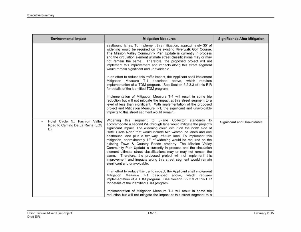
Executive Summary
Union Tribune Mixed Use Project ES-15 February 2015 Draft EIR
Environmental Impact Mitigation Measures Significance After Mitigation
eastbound lanes. To implement this mitigation, approximately 35’ of widening would be required on the existing Riverwalk Golf Course. The Mission Valley Community Plan Update is currently in process and the circulation element ultimate street classifications may or may not remain the same. Therefore, the proposed project will not implement this improvement and impacts along this street segment would remain significant and unavoidable. In an effort to reduce this traffic impact, the Applicant shall implement Mitigation Measure T-1 described above, which requires implementation of a TDM program. See Section 5.2.3.3 of this EIR for details of the identified TDM program. Implementation of Mitigation Measure T-1 will result in some trip reduction but will not mitigate the impact at this street segment to a level of less than significant. With implementation of the proposed project and Mitigation Measure T-1, the significant and unavoidable impacts to this street segment would remain.
• Hotel Circle N.: Fashion Valley Road to Camino De La Reina (LOS E)
Widening this segment to 3-lane Collector standards to accommodate a second WB through lane would mitigate the project’s significant impact. The widening could occur on the north side of Hotel Circle North that would include two westbound lanes and one eastbound lane plus a two-way left-turn lane. To implement this mitigation, approximately 12’ of widening would be required on the existing Town & Country Resort property. The Mission Valley Community Plan Update is currently in process and the circulation element ultimate street classifications may or may not remain the same. Therefore, the proposed project will not implement this improvement and impacts along this street segment would remain significant and unavoidable. In an effort to reduce this traffic impact, the Applicant shall implement Mitigation Measure T-1 described above, which requires implementation of a TDM program. See Section 5.2.3.3 of this EIR for details of the identified TDM program. Implementation of Mitigation Measure T-1 will result in some trip reduction but will not mitigate the impact at this street segment to a
Significant and Unavoidable

Executive Summary
Union Tribune Mixed Use Project ES-16 February 2015 Draft EIR
Environmental Impact Mitigation Measures Significance After Mitigation
level of less than significant. With implementation of the proposed project and Mitigation Measure T-1, the significant and unavoidable impacts to this street segment would remain.
• Hotel Circle S.: I-8 EB Ramps to Bachman Place (LOS F)
Widening this segment to 3-lane Collector standards plus a two-way left-turn lane would mitigate the project’s significant impact. The widening would include two eastbound lanes and one westbound lane. There is an existing 30’ IOD on Hotel Circle South along this roadway segment. Based on a preliminary feasibility analysis conducted as part of the TIA, this widening is deemed infeasible due to building structures fronting Hotel Circle South that would allow only a 2’ parkway, which is not sufficient to include a sidewalk per City standards. Therefore, this mitigation cannot be implemented and impacts along this street segment would remain significant and unavoidable. In an effort to reduce this traffic impact, the Applicant shall implement Mitigation Measure T-1 described above, which requires implementation of a TDM program to partially mitigate the project’s impact at this location. See Section 5.2.3.3 of this EIR for details of the identified TDM program. Implementation of Mitigation Measure T-1 will result in some trip reduction but will not mitigate the impact at this street segment to a level of less than significant. With implementation of the proposed project and Mitigation Measure T-1, the significant and unavoidable impacts to this street segment would remain.
Significant and Unavoidable
• Hotel Circle S.: Bachman Place to Camino De La Reina (LOS F)
Widening this segment to 3-lane Collector standards plus a continuous left-turn lane would mitigate the project’s significant impact. The widening would include two eastbound lanes and one westbound lane. Based on a preliminary feasibility analysis conducted as part of the TIA, this widening is deemed infeasible due to the location of the support columns for the I-8 undercrossing on Hotel Circle South. Therefore, this mitigation cannot be implemented and impacts along this street segment would remain significant and unavoidable. In an effort to reduce this traffic impact, the Applicant shall implement
Significant and Unavoidable

Executive Summary
Union Tribune Mixed Use Project ES-17 February 2015 Draft EIR
Environmental Impact Mitigation Measures Significance After Mitigation
Mitigation Measure T-1 described above, which requires implementation of a TDM program. See Section 5.2.3.3 of this EIR for details of the identified TDM program. Implementation of Mitigation Measure T-1 will result in some trip reduction but will not mitigate the impact at this street segment to a level of less than significant. With implementation of the proposed project and Mitigation Measure T-1, the significant and unavoidable impacts to this street segment would remain.
Near-Term (Opening Day 2017) Conditions
Intersections The proposed project has the potential to result in significant direct impacts to intersection operations at the Hotel Circ S./I-8EB Ramps intersection (LOS F during the PM peak hour) in the Near-Term (Opening Day 2017) Conditions.
To mitigate the project’s direct impact, LLG analyzed three (3) intersection control alternatives, which include a traffic signal, roundabout and an enhanced all-way stop control per recent statewide directive (Caltrans Intersection Control Evaluation (ICE) and Design Guidance). Signalizing the intersection would mitigate the project’s direct impact. However, based on a preliminary feasibility analysis conducted as part of the TIA, signalization of this intersection is not likely to be approved by Caltrans due to the lack of adequate off-ramp queue storage, which may pose safety and operational issues if queues backup onto the freeway mainline. Therefore, the traffic signal alternative is deemed infeasible. A preliminary roundabout evaluation was also conducted. Based on FHWA Guidelines, a 100 to 130 foot diameter roundabout is recommended based on the traffic volumes on Hotel Circle South. As shown in Table 5.2-18, the intersection would still operate at LOS F as a single lane roundabout. Additionally, given that the footprint of the roundabout encroaches on the commercial fronting properties on Hotel Circle South, the roundabout is deemed infeasible from a design and operations perspective. LLG also analyzed an enhanced all-way stop alternative. The enhanced all-way stop control includes a second EB through lane and restriping the WB approach to include two through lanes with a shared right-turn lane. To accommodate the additional lanes at the intersection, widening of Hotel Circle South along the existing Mission Valley Resort is required.
Significant and Unavoidable

Executive Summary
Union Tribune Mixed Use Project ES-18 February 2015 Draft EIR
Environmental Impact Mitigation Measures Significance After Mitigation
The Legacy International Center (LIC) Project proposes to widen Hotel Circle South along its project frontage to include two additional travel lanes to mitigate its impact at this intersection. The Hotel Circle South / I-8 EB ramps intersection would be widened as a part of this improvement to include an additional through lane in each direction. Furthermore, the Mission Valley Community Plan Update is currently in process and the circulation element ultimate street classifications may or may not remain the same. Therefore, this impact would remain significant and unavoidable. In an effort to reduce this traffic impact, the Applicant shall implement Mitigation Measure T-1 described above, which requires implementation of a TDM program. See Section 5.2.3.3 of this EIR for details of the identified TDM program. Implementation of Mitigation Measure T-1 will result in some trip reduction but will not mitigate the impact at this intersection to a level of less than significant. With implementation of the proposed project and Mitigation Measure T-1, the significant and unavoidable impacts to this intersection would remain.
Street Segments The proposed project has the potential to result in significant direct impacts to street segment operations at the following segments in the Near-Term (Opening Day 2017) Conditions:
• Hotel Circle N.: I-8 WB Ramps to Fashion Valley Road (LOS F)
Widening this segment to 4-lane Collector standards to accommodate a second WB through lane would mitigate the project’s significant impact. The widening could occur on the north side of Hotel Circle North to include two westbound lanes and two eastbound lanes. To implement this mitigation, approximately 35’ of widening would be required on the existing Riverwalk Golf Course. The Mission Valley Community Plan Update is currently in process and the circulation element ultimate street classifications may or may not remain the same. Therefore, the proposed project will not
Significant and Unavoidable

Executive Summary
Union Tribune Mixed Use Project ES-19 February 2015 Draft EIR
Environmental Impact Mitigation Measures Significance After Mitigation
implement this improvement and impacts along this street segment would remain significant and unavoidable. In an effort to reduce this traffic impact, the Applicant shall implement Mitigation Measure T-1 described above, which requires implementation of a TDM program. See Section 5.2.3.3 of this EIR for details of the identified TDM program. Implementation of Mitigation Measure T-1 will result in some trip reduction but will not mitigate the impact at this street segment to a level of less than significant. With implementation of the proposed project and Mitigation Measure T-1, the significant and unavoidable impacts to this street segment would remain.
• Hotel Circle N.: Fashion Valley Road to Camino De La Reina (LOS E)
Widening this segment to 3-lane Collector standards to accommodate a second WB through lane would mitigate the project’s significant impact. The widening could occur on the north side of Hotel Circle North that would include two westbound lanes and one eastbound lane plus a two-way left-turn lane. To implement this mitigation, approximately 12’ of widening would be required on the existing Town & Country Resort property. The Mission Valley Community Plan Update is currently in process and the circulation element ultimate street classifications may or may not remain the same. Therefore, the proposed project will not implement this improvement and impacts along this street segment would remain significant and unavoidable. In an effort to reduce this traffic impact, the Applicant shall implement Mitigation Measure T-1 described above, which requires implementation of a TDM program. See Section 5.2.3.3 of this EIR for details of the identified TDM program. Implementation of Mitigation Measure T-1 will result in some trip reduction but will not mitigate the impact at this street segment to a level of less than significant. With implementation of the proposed project and Mitigation Measure T-1, the significant and unavoidable impacts to this street segment would remain.
Significant and Unavoidable
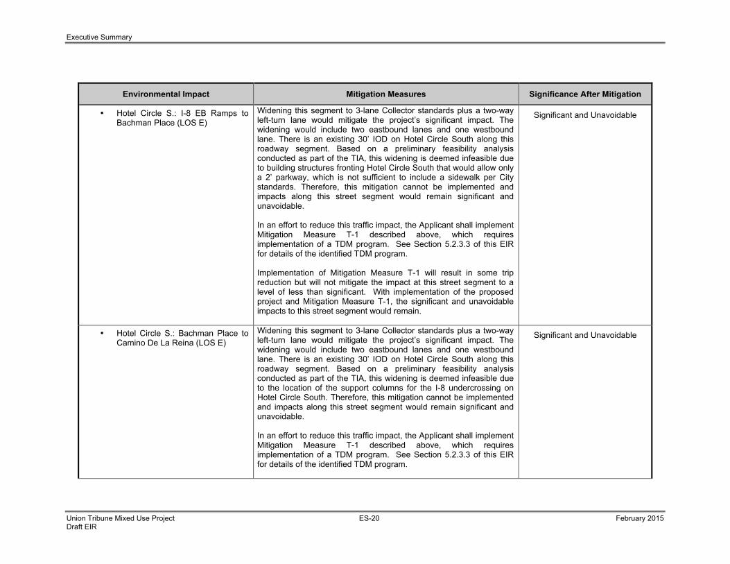
Executive Summary
Union Tribune Mixed Use Project ES-20 February 2015 Draft EIR
Environmental Impact Mitigation Measures Significance After Mitigation
• Hotel Circle S.: I-8 EB Ramps to Bachman Place (LOS E)
Widening this segment to 3-lane Collector standards plus a two-way left-turn lane would mitigate the project’s significant impact. The widening would include two eastbound lanes and one westbound lane. There is an existing 30’ IOD on Hotel Circle South along this roadway segment. Based on a preliminary feasibility analysis conducted as part of the TIA, this widening is deemed infeasible due to building structures fronting Hotel Circle South that would allow only a 2’ parkway, which is not sufficient to include a sidewalk per City standards. Therefore, this mitigation cannot be implemented and impacts along this street segment would remain significant and unavoidable. In an effort to reduce this traffic impact, the Applicant shall implement Mitigation Measure T-1 described above, which requires implementation of a TDM program. See Section 5.2.3.3 of this EIR for details of the identified TDM program. Implementation of Mitigation Measure T-1 will result in some trip reduction but will not mitigate the impact at this street segment to a level of less than significant. With implementation of the proposed project and Mitigation Measure T-1, the significant and unavoidable impacts to this street segment would remain.
Significant and Unavoidable
• Hotel Circle S.: Bachman Place to Camino De La Reina (LOS E)
Widening this segment to 3-lane Collector standards plus a two-way left-turn lane would mitigate the project’s significant impact. The widening would include two eastbound lanes and one westbound lane. There is an existing 30’ IOD on Hotel Circle South along this roadway segment. Based on a preliminary feasibility analysis conducted as part of the TIA, this widening is deemed infeasible due to the location of the support columns for the I-8 undercrossing on Hotel Circle South. Therefore, this mitigation cannot be implemented and impacts along this street segment would remain significant and unavoidable. In an effort to reduce this traffic impact, the Applicant shall implement Mitigation Measure T-1 described above, which requires implementation of a TDM program. See Section 5.2.3.3 of this EIR for details of the identified TDM program.
Significant and Unavoidable

Executive Summary
Union Tribune Mixed Use Project ES-21 February 2015 Draft EIR
Environmental Impact Mitigation Measures Significance After Mitigation
Implementation of Mitigation Measure T-1 will result in some trip reduction but will not mitigate the impact at this street segment to a level of less than significant. With implementation of the proposed project and Mitigation Measure T-1, the significant and unavoidable impacts to this street segment would remain.
Horizon Year (Year 2035) + Project Conditions
Intersections
The proposed project has the potential to result in significant cumulative impacts to intersection operations at the Hotel Circle S./I-8 EB Ramps intersection (LOS F during the AM and PM peak hour).
CUM-1 Prior to issuance of the first building permit, the Owner/Permittee shall contribute a fair-share (4.3%) towards implementing the widening of the Hotel Circle South/I-8 EB Ramps intersection to include a second EB through lane and restriping the WB approach to include two through lanes with a shared right-turn lane, satisfactory to the City Engineer.
Less Than Significant
Street Segments The proposed project has the potential to result in significant cumulative impacts to street segment operations at the following segments in the Horizon Year (Year 2035) + Project Conditions:
• Camino De La Reina: Hotel Circle to Project Driveway (LOS F)
CUM-2 The Applicant shall provide an irrevocable offer of dedication (IOD) and deferred improvement agreement (DIA) for the widening of Camino De La Reina along the project frontage. If this section of Camino De La Reina remains a 4-lane Major classification after approval of the Mission Valley Community Plan Update, the applicant’s widening of the roadway to half width of a 4-lane Major would mitigate the project’s cumulative impact once the widening is completed. In addition, the project also proposes to contribute a fair-share (16.1%) towards restriping with potential widening (to account for appropriate transitions) of Camino De La Reina to 3-lane Collector standards between the southerly UT property line and Hotel Circle. Provision of the IOD, DIA and payment of the fair-share will mitigate the cumulative impact along this
Less Than Significant

Executive Summary
Union Tribune Mixed Use Project ES-22 February 2015 Draft EIR
Environmental Impact Mitigation Measures Significance After Mitigation
segment.
• Camino De La Reina: Project Driveway to Avenida Del Rio (LOS F)
CUM-3 The Applicant shall provide an IOD and DIA for the widening of Camino De La Reina along the project frontage. If this section of Camino De La Reina remains a 4-lane Major classification after approval of the Mission Valley Community Plan Update, the applicant’s widening of the roadway to half width of a 4-lane Major would mitigate the project’s cumulative impact once the widening is completed. In addition, the project also proposes to contribute a fair-share (5.4%) towards widening Camino De La Reina between UT northerly property line and Avenida Del Rio to 3-lane Collector (half width of a 4-lane Major) standards. Provision of the IOD, DIA and payment of the fair-share will mitigate the cumulative impact along this segment.
Less Than Significant
• Hotel Circle N.: I-8 WB Ramps to Fashion Valley Road (LOS F)
CUM-4 Prior to issuance of the first building permit, the Owner/Permittee shall contribute a fair-share (2.4%) towards widening to accommodate a second WB through lane on Hotel Circle North between I-8 WB Ramps and Fashion Valley Road, satisfactory to the City Engineer.
Less Than Significant
• Hotel Circle N.: Fashion Valley Road to Camino De La Reina (LOS F)
CUM-5 Prior to issuance of the first building permit, the Owner/Permittee shall contribute a fair-share (4.2%) towards widening to accommodate a second WB through lane on Hotel Circle North between Fashion Valley Road and Camino De La Reina, satisfactory to the City Engineer.
Less Than Significant
• Hotel Circle S.: I-8 EB Ramps to Bachman Place (LOS F)
Widening this segment to 3-lane Collector standards plus a two-way left-turn lane would mitigate the project’s significant impact. The widening would include two eastbound lanes and one westbound lane. There is an existing 30’ IOD on Hotel Circle South along this roadway segment. Based on a preliminary feasibility analysis conducted as part of the TIA, this widening is deemed infeasible from a technical (physical) standpoint due to building structures fronting Hotel Circle South that would allow only a 2’ parkway, which is not sufficient to include a sidewalk per City standards. Therefore, given the physical infeasibility of the proposed mitigation, this impact is considered cumulatively significant and unmitigated.
Cumulatively Significant and Unmitigated

Executive Summary
Union Tribune Mixed Use Project ES-23 February 2015 Draft EIR
Environmental Impact Mitigation Measures Significance After Mitigation
In an effort to reduce this traffic impact, the Applicant shall implement Mitigation Measure T-1 described above, which requires implementation of a TDM program. See Section 5.2.3.3 of this EIR for details of the identified TDM program. Implementation of Mitigation Measure T-1 will result in some trip reduction but will not mitigate the impact at this street segment to a level of less than significant. With implementation of the proposed project and Mitigation Measure T-1, the cumulatively significant and unavoidable impacts to this street segment would remain.
• Hotel Circle S.: Bachman Place to Camino De La Reina (LOS F)
Widening this segment to a 3-lane Collector standards plus a continuous left-turn lane would mitigate the project’s significant impact. The widening would include two eastbound lanes and one westbound lane. Based on a preliminary feasibility analysis conducted as part of the TIA, this widening is deemed technically (physical) infeasible due to the location of the support columns for the I-8 undercrossing on Hotel Circle South. Therefore, given the physical infeasibility of the proposed mitigation, this impact is considered cumulatively significant and unmitigated. In an effort to reduce this traffic impact, the Applicant shall implement Mitigation Measure T-1 described above, which requires implementation of a TDM program. See Section 5.2.3.3 of this EIR for details of the identified TDM program. Implementation of Mitigation Measure T-1 will result in some trip reduction but will not mitigate the impact at this street segment to a level of less than significant. With implementation of the proposed project and Mitigation Measure T-1, the cumulatively significant and unavoidable impacts to this street segment would remain.
Cumulatively Significant and Unmitigated
Section 5.4 Biological Resources
The proposed project has the potential to result in indirect impacts to adjacent sensitive habitat communities as a result of potentially invasive landscaping.
Refer to Mitigation Measure LU-1 above. Less Than Significant
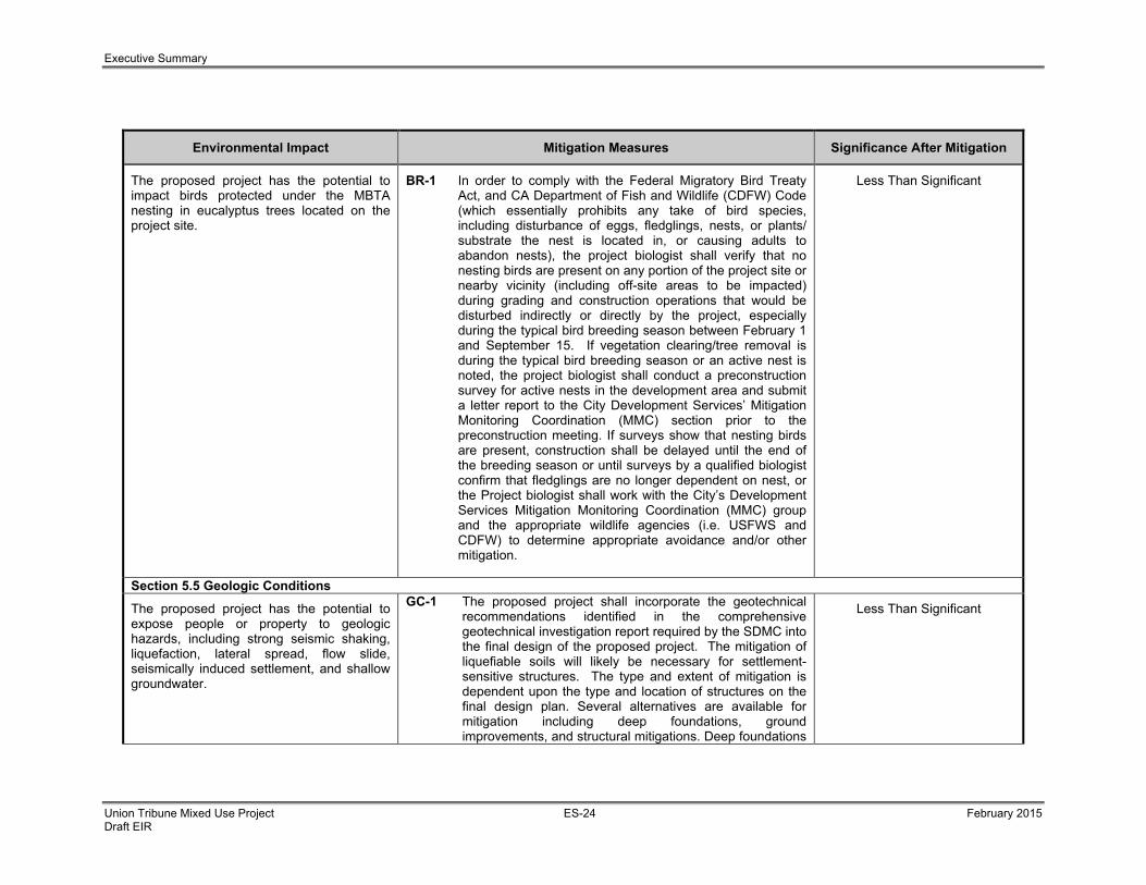
Executive Summary
Union Tribune Mixed Use Project ES-24 February 2015 Draft EIR
Environmental Impact Mitigation Measures Significance After Mitigation
The proposed project has the potential to impact birds protected under the MBTA nesting in eucalyptus trees located on the project site.
BR-1 In order to comply with the Federal Migratory Bird Treaty Act, and CA Department of Fish and Wildlife (CDFW) Code (which essentially prohibits any take of bird species, including disturbance of eggs, fledglings, nests, or plants/ substrate the nest is located in, or causing adults to abandon nests), the project biologist shall verify that no nesting birds are present on any portion of the project site or nearby vicinity (including off-site areas to be impacted) during grading and construction operations that would be disturbed indirectly or directly by the project, especially during the typical bird breeding season between February 1 and September 15. If vegetation clearing/tree removal is during the typical bird breeding season or an active nest is noted, the project biologist shall conduct a preconstruction survey for active nests in the development area and submit a letter report to the City Development Services’ Mitigation Monitoring Coordination (MMC) section prior to the preconstruction meeting. If surveys show that nesting birds are present, construction shall be delayed until the end of the breeding season or until surveys by a qualified biologist confirm that fledglings are no longer dependent on nest, or the Project biologist shall work with the City’s Development Services Mitigation Monitoring Coordination (MMC) group and the appropriate wildlife agencies (i.e. USFWS and CDFW) to determine appropriate avoidance and/or other mitigation.
Less Than Significant
Section 5.5 Geologic Conditions
The proposed project has the potential to expose people or property to geologic hazards, including strong seismic shaking, liquefaction, lateral spread, flow slide, seismically induced settlement, and shallow groundwater.
GC-1 The proposed project shall incorporate the geotechnical recommendations identified in the comprehensive geotechnical investigation report required by the SDMC into the final design of the proposed project. The mitigation of liquefiable soils will likely be necessary for settlement-sensitive structures. The type and extent of mitigation is dependent upon the type and location of structures on the final design plan. Several alternatives are available for mitigation including deep foundations, ground improvements, and structural mitigations. Deep foundations
Less Than Significant

Executive Summary
Union Tribune Mixed Use Project ES-25 February 2015 Draft EIR
Environmental Impact Mitigation Measures Significance After Mitigation
will most likely be recommended to provide structural mitigation of soil liquefaction for the planned residential buildings. Ground improvement (stone columns) and/or a mat slab foundation is/are recommended for the proposed parking structure. Ground improvement should extend at least 15-feet laterally outside to the edge of the planned building structure, where practical. Ground improvement (stone columns) will most likely be recommended to mitigate lateral spread potential along the northern property line. The selection of the type of mitigation and performance standards will depend on the final building plans and building loads.
Section 5.6 Historical Resources
The proposed project has the potential to result in significant impacts to sensitive archaeological resources potentially located on the project site.
HR-1 I. Prior to Permit Issuance A. Entitlements Plan Check
1. Prior to Notice to Proceed (NTP) for any construction permits, including but not limited to, the first Grading Permit, Demolition Plans/Permits and Building Plans/Permits, but prior to the first preconstruction meeting, whichever is applicable, the Assistant Deputy Director (ADD) Environmental designee shall verify that the requirements for Archaeological Monitoring and Native American monitoring have been noted on the appropriate construction documents.
B. Letters of Qualification have been submitted to ADD
1. The applicant shall submit a letter of verification to Mitigation Monitoring Coordination (MMC) identifying the Principal Investigator (PI) for the project and the names of all persons involved in the archaeological monitoring program, as
Less Than Significant

Executive Summary
Union Tribune Mixed Use Project ES-26 February 2015 Draft EIR
Environmental Impact Mitigation Measures Significance After Mitigation
defined in the City of San Diego Historical Resources Guidelines (HRG). If applicable, individuals involved in the archaeological monitoring program must have completed the 40-hour HAZWOPER training with certification documentation.
2. MMC will provide a letter to the applicant confirming the qualifications of the PI and all persons involved in the archaeological monitoring of the project.
3. Prior to the start of work, the applicant must obtain approval from MMC for any personnel changes associated with the monitoring program.
II. Prior to Start of Construction A. Verification of Records Search
1. The PI shall provide verification to MMC that a site-specific records search (1/4 mile radius) has been completed. Verification includes, but is not limited to a copy of a confirmation letter from South Coast Information Center, or, if the search was in-house, a letter of verification from the PI stating that the search was completed.
2. The letter shall introduce any pertinent information concerning expectations and probabilities of discovery during trenching and/or grading activities.
3. The PI may submit a detailed letter to MMC requesting a reduction to the ¼ mile radius.
B. PI Shall Attend Precon Meetings
1. Prior to beginning any work that requires monitoring; the Applicant shall arrange a Precon Meeting that shall include the PI,

Executive Summary
Union Tribune Mixed Use Project ES-27 February 2015 Draft EIR
Environmental Impact Mitigation Measures Significance After Mitigation
Construction Manager (CM) and/or Grading Contractor, Resident Engineer (RE), Building Inspector (BI), if appropriate, and MMC. The qualified Archaeologist and Native American Monitor shall attend any grading/excavation related Precon Meetings to make comments and/or suggestions concerning the Archaeological Monitoring program with the Construction Manager and/or Grading Contractor.
a. If the PI is unable to attend the Precon Meeting, the Applicant shall schedule a focused Precon Meeting with MMC, the PI, RE, CM or BI, if appropriate, prior to the start of any work that requires monitoring.
2. Identify Areas to be Monitored
a. Prior to the start of any work that requires monitoring, the PI shall submit an Archaeological Monitoring Exhibit (AME) based on the appropriate construction documents (reduced to 11x17) to MMC identifying the areas to be monitored including the delineation of grading/excavation limits.
b. The AME shall be based on the results of a site-specific records search as well as information regarding existing known soil conditions (native or formation).
3. When Monitoring Will Occur
a. Prior to the start of any work, the PI shall also submit a construction schedule to MMC through the RE indicating when and where monitoring will occur.

Executive Summary
Union Tribune Mixed Use Project ES-28 February 2015 Draft EIR
Environmental Impact Mitigation Measures Significance After Mitigation
b. The PI may submit a detailed letter to MMC prior to the start of work or during construction requesting a modification to the monitoring program. This request shall be based on relevant information such as review of final construction documents, which indicate site conditions such as depth of excavation and/or site graded to bedrock, etc., which may reduce or increase the potential for resources to be present.
III. During Construction A. Monitor(s) Shall be Present During Grading/Excavation/Trenching
1. The Archaeological Monitor shall be present fulltime during grading/excavation/trenching activities, which could result in impacts to archaeological resources as identified on the AME. The Native American monitor shall determine the extent of their presence during construction related activities based on the AME and provide that information to the PI and MMC. The Construction Manager is responsible for notifying the RE, PI, and MMC of changes to any construction activities.
2. The monitor shall document field activity via the Consultant Site Visit Record (CSVR). The CSVR’s shall be faxed by the CM to the RE the first day of monitoring, the last day of monitoring, monthly (Notification of Monitoring Completion), and in the case of ANY discoveries. The RE shall forward copies to MMC.
3. The PI may submit a detailed letter to MMC during construction requesting a

Executive Summary
Union Tribune Mixed Use Project ES-29 February 2015 Draft EIR
Environmental Impact Mitigation Measures Significance After Mitigation
modification to the monitoring program when a field condition such as modern disturbance post-dating the previous grading/trenching activities, presence of fossil formations, or when native soils are encountered may reduce or increase the potential for resources to be present.
B. Discovery Notification Process
1. In the event of a discovery, the Archaeological Monitor shall direct the contractor to temporarily divert trenching activities in the area of discovery and immediately notify the RE or BI, as appropriate.
2. The Monitor shall immediately notify the PI (unless Monitor is the PI) of the discovery.
3. The PI shall immediately notify MMC by phone of the discovery, and shall also submit written documentation to MMC within 24 hours by fax or email with photos of the resource in context, if possible.
C. Determination of Significance
1. The PI and Native American monitor shall evaluate the significance of the resource. If Human Remains are involved, follow protocol in Section IV below.
a. The PI shall immediately notify MMC by phone to discuss significance determination and shall also submit a letter to MMC indicating whether additional mitigation is required.
b. If the resource is significant, the PI shall submit an Archaeological Data Recovery Program (ADRP) and obtain written approval from MMC. Impacts to significant resources must be mitigated

Executive Summary
Union Tribune Mixed Use Project ES-30 February 2015 Draft EIR
Environmental Impact Mitigation Measures Significance After Mitigation
before ground-disturbing activities in the area of discovery will be allowed to resume.
c. If resource is not significant, the PI shall submit a letter to MMC indicating that artifacts will be collected, curated, and documented in the Final Monitoring Report. The letter shall also indicate that that no further work is required.
IV. Discovery of Human Remains
If human remains are discovered, work shall halt in that area and the following procedures as set forth in the California Public Resources Code (Sec. 5097.98) and State Health and Safety Code (Sec. 7050.5) shall be undertaken:
A. Notification
1. Archaeological Monitor shall notify the RE or BI as appropriate, MMC, and the PI, if the Monitor is not qualified as a PI. MMC will notify the appropriate Senior Planner in the Environmental Analysis Section (EAS).
2. The PI shall notify the Medical Examiner after consultation with the RE, either in person or via telephone.
B. Isolate discovery site
1. Work shall be directed away from the location of the discovery and any nearby area reasonably suspected to overlay adjacent human remains until a determination can be made by the Medical Examiner in consultation with the PI concerning the provenience of the remains.
2. The Medical Examiner, in consultation with the PI, will determine the need for a field

Executive Summary
Union Tribune Mixed Use Project ES-31 February 2015 Draft EIR
Environmental Impact Mitigation Measures Significance After Mitigation
examination to determine the provenience.
3. If a field examination is not warranted, the Medical Examiner will determine with input from the PI, if the remains are or are most likely to be of Native American origin.
C. If Human Remains ARE determined to be Native American
1. The Medical Examiner will notify the Native American Heritage Commission (NAHC) within 24 hours. By law, ONLY the Medical Examiner can make this call.
2. NAHC will immediately identify the person or persons determined to be the Most Likely Descendent (MLD) and provide contact information.
3. The MLD will contact the PI within 24 hours or sooner after the Medical Examiner has completed coordination, to begin the consultation process in accordance with the California Public Resource and Health & Safety Codes.
4. The MLD will have 48 hours to make recommendations to the property owner or representative, for the treatment or disposition with proper dignity, of the human remains and associated grave goods.
5. Disposition of Native American Human Remains shall be determined between the MLD and the PI, IF:
a. The NAHC is unable to identify the MLD, OR the MLD failed to make a recommendation within 48 hours after being notified by the Commission; OR;
b. The landowner or authorized
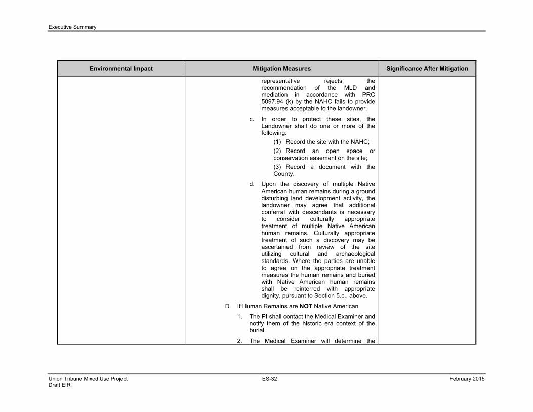
Executive Summary
Union Tribune Mixed Use Project ES-32 February 2015 Draft EIR
Environmental Impact Mitigation Measures Significance After Mitigation
representative rejects the recommendation of the MLD and mediation in accordance with PRC 5097.94 (k) by the NAHC fails to provide measures acceptable to the landowner.
c. In order to protect these sites, the Landowner shall do one or more of the following: (1) Record the site with the NAHC; (2) Record an open space or
conservation easement on the site; (3) Record a document with the
County.
d. Upon the discovery of multiple Native American human remains during a ground disturbing land development activity, the landowner may agree that additional conferral with descendants is necessary to consider culturally appropriate treatment of multiple Native American human remains. Culturally appropriate treatment of such a discovery may be ascertained from review of the site utilizing cultural and archaeological standards. Where the parties are unable to agree on the appropriate treatment measures the human remains and buried with Native American human remains shall be reinterred with appropriate dignity, pursuant to Section 5.c., above.
D. If Human Remains are NOT Native American
1. The PI shall contact the Medical Examiner and notify them of the historic era context of the burial.
2. The Medical Examiner will determine the

Executive Summary
Union Tribune Mixed Use Project ES-33 February 2015 Draft EIR
Environmental Impact Mitigation Measures Significance After Mitigation
appropriate course of action with the PI and City staff (PRC 5097.98).
3. If the remains are of historic origin, they shall be appropriately removed and conveyed to the Museum of Man for analysis. The decision for internment of the human remains shall be made in consultation with MMC, EAS, the applicant/landowner and the Museum of Man
V. Night and/or Weekend Work A. If night and/or weekend work is included in the contract
1. When night and/or weekend work is included in the contract package, the extent and timing shall be presented and discussed at the precon meeting.
2. The following procedures shall be followed. a. No Discoveries In the event that no discoveries were
encountered during night and/or weekend work, the PI shall record the information on the CSVR and submit to MMC via fax by 8AM of the next business day.
b. Discoveries All discoveries shall be processed and
documented using the existing procedures detailed in Sections III - During Construction, and IV – Discovery of Human Remains.
c. Potentially Significant Discoveries If the PI determines that a potentially
significant discovery has been made, the procedures detailed under Section III - During Construction shall be followed.
d. The PI shall immediately contact MMC, or
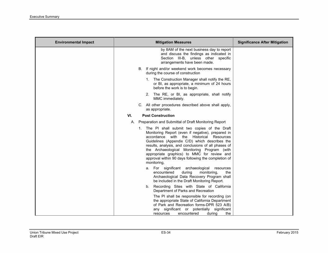
Executive Summary
Union Tribune Mixed Use Project ES-34 February 2015 Draft EIR
Environmental Impact Mitigation Measures Significance After Mitigation
by 8AM of the next business day to report and discuss the findings as indicated in Section III-B, unless other specific arrangements have been made.
B. If night and/or weekend work becomes necessary during the course of construction
1. The Construction Manager shall notify the RE, or BI, as appropriate, a minimum of 24 hours before the work is to begin.
2. The RE, or BI, as appropriate, shall notify MMC immediately.
C. All other procedures described above shall apply, as appropriate.
VI. Post Construction A. Preparation and Submittal of Draft Monitoring Report
1. The PI shall submit two copies of the Draft Monitoring Report (even if negative), prepared in accordance with the Historical Resources Guidelines (Appendix C/D) which describes the results, analysis, and conclusions of all phases of the Archaeological Monitoring Program (with appropriate graphics) to MMC for review and approval within 90 days following the completion of monitoring, a. For significant archaeological resources
encountered during monitoring, the Archaeological Data Recovery Program shall be included in the Draft Monitoring Report.
b. Recording Sites with State of California Department of Parks and Recreation
The PI shall be responsible for recording (on the appropriate State of California Department of Park and Recreation forms-DPR 523 A/B) any significant or potentially significant resources encountered during the

Executive Summary
Union Tribune Mixed Use Project ES-35 February 2015 Draft EIR
Environmental Impact Mitigation Measures Significance After Mitigation
Archaeological Monitoring Program in accordance with the City’s Historical Resources Guidelines, and submittal of such forms to the South Coastal Information Center with the Final Monitoring Report.
2. MMC shall return the Draft Monitoring Report to the PI for revision or, for preparation of the Final Report.
3. The PI shall submit revised Draft Monitoring Report to MMC for approval.
4. MMC shall provide written verification to the PI of the approved report.
5. MMC shall notify the RE or BI, as appropriate, of receipt of all Draft Monitoring Report submittals and approvals.
B. Handling of Artifacts
1. The PI shall be responsible for ensuring that all cultural remains collected are cleaned and catalogued
2. The PI shall be responsible for ensuring that all artifacts are analyzed to identify function and chronology as they relate to the history of the area; that faunal material is identified as to species; and that specialty studies are completed, as appropriate.
3. The cost for curation is the responsibility of the property owner.
C. Curation of artifacts: Accession Agreement and Acceptance Verification
1. The PI shall be responsible for ensuring that all artifacts associated with the survey, testing and/or data recovery for this project are permanently curated with an appropriate institution. This shall be completed in consultation with MMC and the

Executive Summary
Union Tribune Mixed Use Project ES-36 February 2015 Draft EIR
Environmental Impact Mitigation Measures Significance After Mitigation
Native American representative, as applicable.
2. The PI shall include the Acceptance Verification from the curation institution in the Final Monitoring Report submitted to the RE or BI and MMC.
D. Final Monitoring Report(s)
1. The PI shall submit one copy of the approved Final Monitoring Report to the RE or BI as appropriate, and one copy to MMC (even if negative), within 90 days after notification from MMC that the draft report has been approved.
2. The RE shall, in no case, issue the Notice of Completion and/or release of the Performance Bond for grading until receiving a copy of the approved Final Monitoring Report from MMC, which includes the Acceptance Verification from the curation institution.
Section 5.12 Paleontological Resources
The proposed project has the potential to result in significant impacts to paleontological resources potentially present within the Stadium Conglomerate.
PR-1 I. Prior to Permit Issuance
A. Entitlements Plan Check 1. Prior to the issuance of a Notice to Proceed
(NTP) or any construction permits, including but not limited to, the first Grading Permit, Demolition Plans/Permits and Building Plans/Permits, but prior to the first preconstruction meeting, whichever is applicable, the Assistant Deputy Director (ADD) Environmental Designee shall verify that the requirements for Paleontological Monitoring have been noted on the appropriate construction documents.
B. Letters of Qualifications have been submitted to ADD
1. Prior to the NTP, and/or issuance of a Grading Permit, Demolition Permit or Building
Less than Significant

Executive Summary
Union Tribune Mixed Use Project ES-37 February 2015 Draft EIR
Environmental Impact Mitigation Measures Significance After Mitigation
Permit, the applicant shall provide a letter of verification to Mitigation Monitoring Coordination (MMC) identifying the Principal Investigator (PI) for the project and the names of all persons involved in the paleontological monitoring program, as defined in the City of San Diego Paleontology Guidelines.
2. The MMC will provide a letter to the applicant confirming the qualifications of the PI and all persons involved in the paleontological monitoring of the project.
3. Prior to the start of work, the applicant shall obtain approval from MMC for any personnel changes associated with the monitoring program.
II. Prior to the Start of Construction
A. Verification of Records Search 1. The PI shall provide verification to MMC that
a site-specific records search has been completed. Verification includes, but is not limited to a copy of a confirmation letter from San Diego Natural History Museum, other institution or, if the search was in-house, a letter of verification from the PI stating that the search was completed.
2. The letter shall introduce any pertinent information concerning expectations and probabilities of discovery during trenching and/or grading activities.
B. PI Shall Attend Precon Meetings 1. Prior to beginning of any work that requires
monitoring, the Applicant shall arrange a Pre-Construction (Precon) Meeting that shall include the PI, Construction Manager (CM) and/or Grading Contractor, Resident Engineer (RE), Building inspector (BI), if

Executive Summary
Union Tribune Mixed Use Project ES-38 February 2015 Draft EIR
Environmental Impact Mitigation Measures Significance After Mitigation
appropriate, and MMC. The qualified paleontologist shall attend any grading-related Precon Meetings to make comments and/or suggestions concerning the Paleontological Monitoring Program with the Construction Manager and/or Grading Contractor.
a. If the Monitor is unable to attend the Precon Meeting, the Applicant shall schedule a focused Precon Meeting with MMC, the RE, CM, or BI as appropriate, to meet and review the job on-site prior to start of any work that requires monitoring.
2. Identify Areas to be Monitored Prior to the start of any work that requires
monitoring, the PI shall submit a Paleontological Monitoring Exhibit (PME) based on the appropriate construction documents (reduced to 11x17) to MMC identifying the areas to be monitored including the delineation of grading/excavation limits. The PME shall be based on the results of a site-specific records search as well as information regarding existing known soil conditions (native or formation).
3. When Monitoring Will Occur a. Prior to the start of any work, the PI shall
also submit a construction schedule to MMC through the RE indicating when and where monitoring will occur.
b. The PI may submit a detailed letter to MMC prior to the start of work or during construction requesting a modification to the monitoring program. This request shall be based on relevant information such as review of final construction
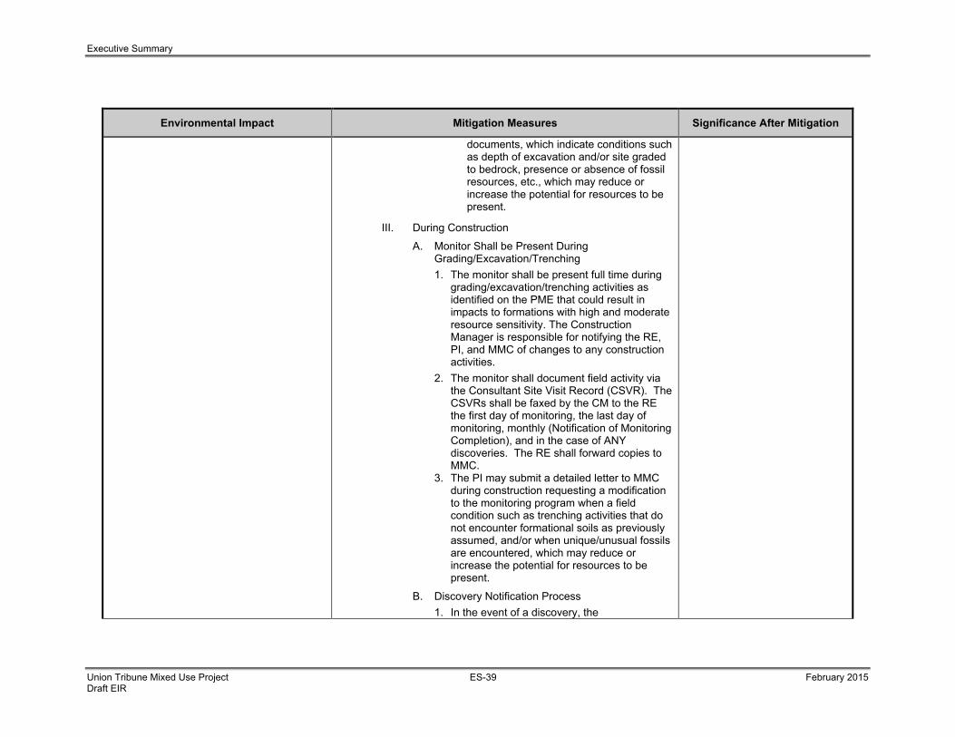
Executive Summary
Union Tribune Mixed Use Project ES-39 February 2015 Draft EIR
Environmental Impact Mitigation Measures Significance After Mitigation
documents, which indicate conditions such as depth of excavation and/or site graded to bedrock, presence or absence of fossil resources, etc., which may reduce or increase the potential for resources to be present.
III. During Construction
A. Monitor Shall be Present During Grading/Excavation/Trenching
1. The monitor shall be present full time during grading/excavation/trenching activities as identified on the PME that could result in impacts to formations with high and moderate resource sensitivity. The Construction Manager is responsible for notifying the RE, PI, and MMC of changes to any construction activities.
2. The monitor shall document field activity via the Consultant Site Visit Record (CSVR). The CSVRs shall be faxed by the CM to the RE the first day of monitoring, the last day of monitoring, monthly (Notification of Monitoring Completion), and in the case of ANY discoveries. The RE shall forward copies to MMC.
3. The PI may submit a detailed letter to MMC during construction requesting a modification to the monitoring program when a field condition such as trenching activities that do not encounter formational soils as previously assumed, and/or when unique/unusual fossils are encountered, which may reduce or increase the potential for resources to be present.
B. Discovery Notification Process 1. In the event of a discovery, the

Executive Summary
Union Tribune Mixed Use Project ES-40 February 2015 Draft EIR
Environmental Impact Mitigation Measures Significance After Mitigation
Paleontological Monitor shall direct the contractor to temporarily divert trenching activities in the area of discover and immediately notify the RE or BI, as appropriate.
2. The Monitor shall immediately notify the PI (unless Monitor is the PI) of the discovery.
3. The PI shall immediately notify MMC by phone of the discovery, and shall also submit written documentation to MMC within 24 hours by fax or email with photos of the resource in context, if possible.
C. Determination of Significance 1. The PI shall evaluate the significance of the
resource. a. The PI shall immediately notify MMC by
phone to discuss significance determination and shall also submit a letter to MMC indicating whether additional mitigation is required. The determination of significance for fossil discoveries shall be at the discretion of the PI.
b. If the resource is significant, the PI shall submit a Paleontological Recovery Program (PRP) and obtain written approval from MMC. Impacts to significant resources must be mitigated before ground-disturbing activities in the area of discovery will be allowed to resume.
c. If resource is not significant (e.g., small pieces of broken common shell fragments or other scattered common fossils) the PI shall notify the RE, or BI as appropriate, that a non-significant discovery has been made. The

Executive Summary
Union Tribune Mixed Use Project ES-41 February 2015 Draft EIR
Environmental Impact Mitigation Measures Significance After Mitigation
Paleontologist shall continue to monitor the area without notification to MMC unless a significant resource is encountered.
d. The PI shall submit a letter to MMC indicating that fossil resources will be collected, curated, and documented in the Final Monitoring Report. The letter shall also indicate that no further work is required.
VI. Night Work
A. If night work is included in the contract 1. When night work is included in the contract
package, the extent and timing shall be presented and discussed at the Precon Meeting.
2. The following procedures shall be followed: a. No Discoveries
In the event that no discoveries were encountered during night work, The PI shall record the information on the CSVR and submit to MMC via fax by 9:00 a.m. the following morning, if possible.
b. Discoveries All discoveries shall be processed and documented using the existing procedures detailed in Sections III – During Construction.
c. Potentially Significant Discoveries If the PI determines that potentially
significant discovery has been made, the procedures detailed under Section III – During Construction shall be followed.
d. The PI shall immediately contact MMC, or by 8:00 a.m. the following morning to

Executive Summary
Union Tribune Mixed Use Project ES-42 February 2015 Draft EIR
Environmental Impact Mitigation Measures Significance After Mitigation
report and discuss the findings as indicated in Section III-B, unless other specific arrangements have been made.
B. If night work becomes necessary during the course of construction
1. The Construction Manager shall notify the RE, or BI, as appropriate, a minimum of 24 hours before the work is to begin.
2. The RE or BI, as appropriate, shall notify MMC immediately.
C. All other procedures described above shall apply, as appropriate.
V. Post Construction
A. Submittal of Draft Monitoring Report 1. The PI shall submit two copies of the Draft
Monitoring Report (even if negative), which describes the results, analysis, and conclusions of all phases of the Paleontological Monitoring Program (with appropriate graphics) to MMC for review and approval within 90 days following the completion of monitoring.
a. For significant paleontological resources encountered during monitoring, the Paleontological Recovery Program shall be included in the Draft Monitoring Report.
b. Recording Sites with the San Diego Natural History Museum
The PI shall be responsible for recording (on the appropriate forms) any significant or potentially significant fossil resources encountered during the Paleontological Monitoring Program in accordance with the City’s Paleontological Guidelines,

Executive Summary
Union Tribune Mixed Use Project ES-43 February 2015 Draft EIR
Environmental Impact Mitigation Measures Significance After Mitigation
and submittal of such forms to the San Diego Natural History Museum with the Final Monitoring Report.
2. MMC shall return the Draft Monitoring Report to the PI for revisions or for preparation of the Final Report.
3. The PI shall submit revised Draft Monitoring Report to MMC for approval.
4. MMC shall provide written verification to the PI of the approved report.
5. MMC shall notify the RE or BI, as appropriate, of receipt of all Draft Monitoring Report submittals and approvals.
B. Handling of Fossil Remains 1. The PI shall be responsible for ensuring that
all fossil remains collected are cleaned and catalogued.
2. The PI shall be responsible for ensuring that all fossil remains are analyzed to identify function and chronology as they relate to the geologic history of the area; that faunal material is identified as to species; and that specialty studies are completed, as appropriate.
C. Curation of Fossil Remains: Deed of Gift and Acceptance Verification
1. The PI shall be responsible for ensuring that all fossil remains associated with the monitoring for this project are permanently curated with an appropriate institution.
2. The PI shall include the Acceptance Verification from the curation institution in the Final Monitoring Report submitted to the RE or BI and MMC.
D. Final Monitoring Report(s)

Executive Summary
Union Tribune Mixed Use Project ES-44 February 2015 Draft EIR
Environmental Impact Mitigation Measures Significance After Mitigation
1. The PI shall submit two copies of the Final Monitoring Report to MMC (even if negative), within 90 days after notification from MMC that the draft report has been approved.
2. The RE shall, in no case, issue the Notice of Completion until receiving a copy of the approved Final Monitoring Report from MMC, which includes the Acceptance Verification from the curation institution.
Section 5.14 Noise
The proposed project has the potential to result in indirect noise impacts to adjacent sensitive habitat and biological resources during construction.
Refer to Mitigation Measures LU-1 and BR-1 above. Less Than Significant

Chapter 1.0 – Introduction
Union Tribune Mixed Use Project 1-1 February 2015 Draft EIR
1.0 INTRODUCTION This Environmental Impact Report (EIR) evaluates the potential short-term and long-term, direct and indirect, and
cumulative environmental impacts of the Union Tribune Mixed Use Project (proposed project). The proposed project
is the redevelopment of the existing Mission Valley headquarters site of the San Diego Union Tribune. The project is
described as an estimated $200-million, pedestrian-friendly, transit-oriented, mixed-use project that will add
residential housing, public open space,, and retail uses to existing office, and manufacturing space. The site is near
natural vegetation associated with the San Diego River. The location of the project site is depicted in Figure 1-1,
Regional Map, and Figure 1-2, Local Vicinity Map.
Specifically, the project would include:
• New seven-story multi-unit residential buildings featuring 200 dwelling units for a total of 285,645 square feet
of gross floor area;
• Four stories of parking, featuring 671 parking spaces for a total of 212,069 square feet of gross floor area, to
be located on a below-grade level and the first three levels of one of the residential buildings (Northwest
Building);
• Conversion of 3,000 square feet of ground floor area of the existing UT printing building to retail amenity
space; and,
• Implementation of the San Diego River Park Master Plan along the northern boundary of the project,
including an extension of the San Diego River Park trail from the Town and Country Resort property to the
west, and the provision of a public pocket park adjacent to the River Park area, which would include
approximately 35,402 square feet (River Park is 23,455 square feet and public pocket park is 11,947 square
feet).
The City of San Diego (City) is the lead agency in preparing this EIR in accordance with the California Environmental
Quality Act (CEQA) of 1970 (California Resources Code, Section 21000 et seq.) and CEQA Guidelines (14 CCR
15000 et seq.). The project applicant, Mission Valley Holdings LLC, has submitted an application for discretionary
approval consisting of a Vesting Tentative Map (VTM), Site Development Permit (SDP), and Planned Development
Permit (PDP).
The overall project site is less than 13 acres and is located at 350 Camino De La Reina, in the area loosely bounded
by Interstate 8, State Route 163, the San Diego River and Fashion Valley within the Mission Valley Community. The
site is occupied by 168,575 square feet of office space (Union Tribune offices) and 191,600 square feet of
manufacturing land uses (Union Tribune printing facility). In addition, the site is also occupied by an existing 2,474
square foot, one-story automotive service center located adjacent to the existing printing facility, which previously
included a fuel station for on-site truck operations. However, the automotive service center was terminated from
operation several years ago. The project site is located within the Mission Valley Master Plan Area and currently
operates as the Union Tribune’s Headquarters from which the newspaper is written, edited, printed and distributed.
Figure 1-3 provides an aerial view of the existing site.

FIGURE
1-1Regional Location
Union Tribune Mixed Use Project EIRSOURCE: SanGIS, 2014; BRG Consulting, Inc., 2014 10/22/14
BRG CONSULTING, INC.
_̂
§̈¦5
§̈¦15
§̈¦805
§̈¦5
¬«78
¬«56
¬«163
¬«52
§̈¦805
§̈¦8
¬«54
¬«125
¬«94
CAMP PENDLETON
±0 2 4 6 8
Miles
Pacific Ocean
Project Location
1-2

I-8 EB
I-8 WB
FRIARS RD
SR-163 SB
SR-1
63 N
B
TEXA
S S
T
CAM DE LA REINA
MEADE AV
PAR
K B
L
ARIZ
ON
A S
T
FLO
RID
A ST
ALA
BAM
A S
T
GE
OR
GIA
ST
CAM DEL RIO SOUTH
LINDA VISTA RD
LOU
ISIA
NA
ST
MONROE AV
MIS
SIS
SIP
PI S
T
ULRIC ST
CAM DEL RIO NORTH
BIS
ST
CLE
VE
LAN
D A
V
PINE ST
HOTEL C RCLE SOUTH
HOTEL CIRCLE NORTH
CAM
PU
S A
V
GLIDDEN ST
SUNSET BL
I-8 WB OFF RA
BAC
HM
AN
PL
FALC
ON
ST
W MONTECITO WY
HOWARD AVTRIA
S ST
VIA
LAS
CU
MB
RES
EL CAJON BL
HAW
K S
T
NORM
AL S
T
GO
LDFI
NC
H S
T
BUR
TON
ST
NO
RTH
AV
JAC
KD
AW S
T
AMPU
DIA S
T
FRAZEE RD
LINCOLN AV
HICKORY ST
MA
RYL
AN
D S
T
CO
LUSA ST
HUNTER ST
RILEY ST
W WASHINGTON ST
I-8 EB OFF RA
ALLEN R
D
COO
LIDG
E ST
I-8 EB ON RA
10TH
AV
ALLE
Y
06TH
EX
ST
FASHIO
N VALLEY R
D
GAINES ST
OKLAHOMA ST
01S
T AV
LAR
K S
T
04TH
AV
MISSION AV
WASH NGTON PL
0R
D A
VARBOR DR
WIT
HERBY
ST
SR-163 RA
ING
ALL
S S
T
MADISON AV
MARIAN WY
W LEWIS ST
JOHNSON AV
LAURETTA ST
E ST
HAYES AV
VOLTA CT
08H
AV
FRIARS RD RA
BARR AV
JUAN ST
SR-163 SB ON RA
FRO
NT
ST
GUY ST
CAM
CO
PETE
SR-163 SB O
FF RA
ALCALA KNOLLS DR
ADAMS AV
NO
RTH
RIM
CT
WHITMAN ST
LEWIS ST
06TH
AV
ACH
ES
ON
ST
TYLER AV
ARC
H ST
SR-1
63 N
B O
N R
A
DICK NSON ST
MILDRED ST
NEW
JE
RS
EY
ST
ARISTA DR
MISSION CENTER CT
W ARBOR DR
CAM DEGRAZIA
MLL
ER
ST
ALTAMIRA PL
POLK AV
SHERIDAN AV
WASHINGTON ST
CAMTO JUANICO
CLIFF ST
DO
VE
ST
LOM
ITA
S D
R
ARCADIA DR
SHIR
LEY
AN
N P
L
EAG
LE S
T
CAM ZALCE
BABETTE ST
CONDE ST
DEL
AWAR
E S
T
MISSION AV
ALLE
YALLE
Y
ALLE
Y
ALLE
Y
LAR
K S
T
MONROE AV
ALLE
YALLE
Y
SR-1
63 R
A
DO
VE
ST
W LEWIS ST
ALLEY
MADISON AV
ALLE
Y
ALLEY
LLE
Y
ALLE
YE
Y
EAG
LE S
T
03R
D A
V
ALLE
Y
LLE
Y
ADAMS AVADAMS AV
HAW
K S
T
I-8 E
ALLE
Y
ALLEY
Source: Esri, DigitalGlobe, GeoEye, i-cubed, USDA, USGS N, ,swisstopo, and the GIS User Community
FIGURE
1-2Local Vicinity Map
Union Tribune Mixed Use Project EIRSOURCE: Esri, 2014; SanGIS, 2014 10/22/14
_̂
Location Within San Diego County
¬«163
§̈¦8
Project Location
0 0.1 0.2 0.3 0.4Miles ±
BRG CONSULTING INC
1-3

FIGURE
1-3Aerial Map of the Project Site
Union Tribune Mixed Use Project EIRSOURCE: Esri, 2014; SanGIS, 2014 10/22/14
CAMINO DE LA REINA
Source: Esri, DigitalGlobe, GeoEye, i-cub Getmapping, Aerogrid, IGN IGP Community
±0 30 60 90 120Feet
BRG CONSULTING INC
1-4

Chapter 1.0 – Introduction
Union Tribune Mixed Use Project 1-5 February 2015 Draft EIR
EIRs are informational documents “which will inform public agency decision makers and the public generally of the
significant environmental effect of a project, identify possible ways to minimize the significant effects, and describe
reasonable alternatives to the project” (14 CCR 15121). The purpose of this EIR is to evaluate the environmental
effects of the project.
This EIR is intended for use by both the decision makers and the public. It provides relevant information concerning
the potential environmental effects associated with the construction and operation of the proposed project.
1.1 CEQA Requirements
1.1.1 CEQA Compliance CEQA (California Resources Code, Section 21000 et seq.) requires the preparation of an EIR for any project that a
lead agency determines may have a significant effect on the environment. According to Section 21002.1(a) of the
CEQA Statutes, “the purpose of an environmental impact report is to identify the significant effects on the
environment of a project, to identify alternatives to the project, and to indicate the manner in which those significant
effects can be mitigated or avoided.” CEQA also establishes mechanisms whereby the public and decision makers
can be informed about the nature of the project being proposed, and the extent and types of impacts that the project
and its alternatives would have on the environment if they were to be implemented. This EIR has been prepared to
comply with all criteria, standards, and procedures of the State CEQA Guidelines (14 CCR 15000 et seq.).
This EIR has also been prepared pursuant to the City’s CEQA Significance Thresholds (City of San Diego, 2011).
This document has been prepared as a project EIR pursuant to Section 15161 of the CEQA Guidelines, and it
represents the independent judgment of the City as the lead agency.
1.1.2 Notice of Preparation and Scoping Meeting The scope of analysis for the EIR was determined by the City in a scoping letter dated March 13, 2013, as well as a
result of public responses to the Scoping Letter and Notice of Preparation (NOP). In compliance with Section 15082
of the CEQA Guidelines, the City Development Services Department circulated the NOP and Scoping Letter to
interested agencies, groups, and individuals. The 30-day public review period for the NOP ended on April 12, 2013.
In addition, a public scoping meeting was held on March 27, 2013, at the Union Tribune Building, located at 350
Camino de la Reina, San Diego, CA 92108 to gather additional public input. Comments received during the NOP
scoping period and meeting were considered during the preparation of this EIR. The NOP, Scoping Letter, and
comments received are included as Appendix A of this EIR. Based on the scope of analysis of this EIR, the following
issues were determined to be potentially significant and are therefore addressed in Chapter 5.0 – Environmental
Analysis of this EIR:
• Land Use
• Traffic/Circulation/Parking
• Greenhouse Gas Emissions
• Biological Resources
• Geologic Conditions
• Historical Resources (Archaeological)
• Hydrology
• Public Services and Facilities
• Public Utilities
• Visual Effects/Neighborhood Character

Chapter 1.0 – Introduction
Union Tribune Mixed Use Project 1-6 February 2015 Draft EIR
• Water Quality
• Paleontological Resources
• Air Quality
• Noise
In addition, comment letters received during the NOP public scoping period expressed concerns about hazardous
materials, cultural resources (Native American concerns), biological resources, hydrology and water quality, water
usage, and traffic. Theses concerns have been identified as areas of known controversy and are also analyzed in
this EIR.
Based on the environmental analysis of the proposed project, additional CEQA-mandated environmental topics, such
as agricultural and forestry resources, health and safety and hazardous materials, historical resources (built
environment), mineral resources, population and housing, and recreation were not found to be significant. These
issues are addressed in Chapter 7.0 – Effects Found Not to be Significant, of this EIR. 1.2 Purpose and Uses of this EIR This project EIR evaluates the potentially significant environmental effects that would result with the implementation
of the proposed project.
This EIR is available for review by members of the public and public agencies for 45 days to provide comments “on
the sufficiency of the document in identifying and analyzing the possible impacts on the environment and ways in
which the significant effects of the project might be avoided or mitigated” (14 CCR 15002). The EIR is available for
review at the following locations:
City of San Diego, Development Services Department
1222 First Avenue, Fifth Floor
San Diego, California 92101
Mission Valley Branch Library
2123 Fenton Parkway
San Diego, California 92108
Mission Hills Branch Library
925 Washington Street
San Diego, California 92103
In addition, the draft EIR and associated technical appendices will be placed on the City of San Diego website.
The Notice of Availability of the EIR has been mailed as required by the CEQA Guidelines and the City.
As the designated lead agency, the City has assumed responsibility for preparing this document. The decision to
approve the project is within the purview of the City Planning Commission (Process 4). When deciding whether to
approve the project, the City will use the information included in this EIR to consider potential impacts on the physical
environment associated with the proposed project.

Chapter 1.0 – Introduction
Union Tribune Mixed Use Project 1-7 February 2015 Draft EIR
The City will consider written comments received on the EIR in making its decision to certify the EIR as complete and
in compliance with CEQA, and also whether to approve or deny the project. In the final review, environmental
considerations and economic and social factors will be weighed to determine the most appropriate course of action.
The City will use the EIR and supporting documentation in its decision to issue discretionary permits including a VTM,
SDP, PDP, and to approve a shared parking agreement. Subsequent to certification of the EIR, any agencies with
permitting authority over all or portions of the proposed project would use the EIR as the basis for their evaluation of
environmental effects of the project and approval or denial of applicable permits.
Additional information regarding City and agency permits and approvals is detailed in Section 3.3 of this EIR.
1.3 EIR Format An executive summary of this EIR is provided at the beginning of the document. The summary includes the
conclusions of the environmental analysis and a comparative summary of the project with the alternatives analyzed in
the EIR. Chapter 1.0, Introduction, introduces the project in light of the required environmental review procedures.
Chapter 2.0, Environmental Setting, describes the project location and physical environmental setting. Chapter 3.0,
Project Description, provides the project description, the purpose and objectives of the project, required discretionary
approvals, and a brief description of the project changes in response to environmental issues. Chapter 4.0, History of
Project Changes, provides a description of changes to the project since it was originally submitted. Chapter 5.0
consists of the environmental analysis, which examines the potentially significant environmental issues. Chapter 6.0,
Cumulative Impacts, addresses cumulative impacts. Chapter 7.0 addresses effects found not to be significant.
Chapter 8.0 addresses other required CEQA topics. Chapter 9.0, Alternatives, addresses a reasonable range of
project alternatives, and Chapter 10.0, includes the project specific Mitigation, Monitoring and Reporting Program.
The remaining EIR sections and appendices are provided as set forth in the table of contents.

Chapter 1.0 – Introduction
Union Tribune Mixed Use Project 1-8 February 2015 Draft EIR
This page intentionally left blank.

Chapter 2.0 – Environmental Setting
Union Tribune Mixed Use Project 2-1 February 2015 Draft EIR
2.0 ENVIRONMENTAL SETTING This chapter provides a description of existing site conditions for the Union Tribune Mixed Use Project (project) site.
The section also provides an overview of the local and regional environmental setting of the project, per Section
15125 of the CEQA Guidelines. More details regarding the setting specifically pertaining to each environmental issue
are provided at the beginning of each impact area addressed in Chapter 5.0 – Environmental Analysis.
2.1 Location The project site is centrally located in the City of San Diego (City), within the Mission Valley Community Planning
Area (see Figure 1-1, Regional Map). The Mission Valley Community Planning Area is comprised of approximately
2,418 net acres and is bound on the west by Interstate 5 (I-5), on the north by Friars Road west of State Route 163
(SR-163) and by the northern slopes of the valley east of SR-163, on the east by the eastern bank of the San Diego
River, and on the south by the southern slopes of the valley. More specifically, the project site is located at the
northwest corner of Interstate 8 (I-8) and SR-163, at 350 Camino De La Reina, San Diego, California, 92108. The
project site comprises of Lot 2 of Map No. 6860 (APN 437-260-41). The project site fronts Camino De La Reina to the
south and east, and is bounded by the San Diego River to the north, and the Town and Country Hotel to the west.
The project site is approximately two miles northeast of San Diego International Airport and three miles southwest of
Montgomery Field.
2.2 Physical Characteristics
2.2.1 Existing On-Site Uses The project site is approximately 12.86 acres and has been graded and developed. The site is currently developed
with the Union-Tribune office building, a separate printing facility, automotive service center, and a surface parking lot
(see Figure 1-3, Aerial Map of the Project Site).
2.2.2 Existing Physical Site Conditions The project site is currently occupied by a surface parking lot on the northern half of the property. The office building
is located on the southeast corner, and the printing facility on the southwest corner. There is currently street frontage
on Camino De La Reina to the south, between the two buildings, and to the east, north of the office building.
Topography of the project site is generally flat but slopes gently down toward the San Diego River to the north.
Elevations range from approximately 40 feet above mean sea level (AMSL) at the southern end of the property to 28
feet AMSL at the northern end. Descriptions of additional on-site physical characteristics, such as biological,
geological and water resources are provided in their respective sections of Chapter 5.0 of this EIR.
2.3 Surrounding Land Uses The project site is located in an urban setting and is surrounded by the San Diego River, existing development, and
major transportation corridors. The project site is surrounded by a mix of commercial and office uses. Adjacent to the
project site to the west is the Town and Country Hotel, and the Mission Valley Convention Center and Riverwalk Golf
Course located west of that. Across Camino De La Reina to the east is a complex of office buildings. To the north is

Chapter 2.0 – Environmental Setting
Union Tribune Mixed Use Project 2-2 February 2015 Draft EIR
the San Diego River, and north of the San Diego River is the San Diego Trolley green line and the Fashion Valley
shopping mall. South of I-8 is the eastern end of Hotel Circle, comprised entirely of lodging and accommodations.
2.4 Applicable Land Use Plans Section 15125(d) of the CEQA Guidelines requires that a discussion of the inconsistencies between the project and
applicable general plans and regional plans be provided. The consistency analysis for the project with applicable
plans, policies, and regulations is provided in Section 5.1 of the EIR. The following summarizes the plans, policies,
and regulations that are applicable to the project.
2.4.1 City of San Diego General Plan The City of San Diego General Plan consists of development policies, in the form of Findings, Goals, Guidelines,
Standards, and Recommendations for a variety of elements. The General Plan also references a series of
community plans, which are intended to provide more area-specific guidance on development in San Diego. The
General Plan’s planned land use designation for the project site is “Industrial” (Category 4 – General). A detailed
analysis of the project’s consistency in the context of the applicable elements of the General Plan is provided in
Section 5.1 of this EIR.
2.4.2 Mission Valley Community Plan The Mission Valley Community Plan is the City’s statement of policy for the physical development of the community
of Mission Valley. Mission Valley is primarily a business community with much of its developable land devoted to
commercial and office uses. The Mission Valley Community Plan establishes goals, policies and proposals for each
of the following elements: Land Use, Transportation, Open Space, Development Intensity, Community Facilities,
Conservation, Cultural and Heritage Resources, Urban Design, and Implementation. The project site is currently
designated as Industrial Park. A detailed analysis of the project’s consistency in the context of the applicable
elements of the Mission Valley Community Plan is provided in Section 5.1 of this EIR.
2.4.3 San Diego River Park Master Plan The San Diego River Park Master Plan is a policy document that provides recommendations and guidelines to be
considered in concert with land use decisions along the San Diego River. The goal of the plan is to create a
continuous river park linking all 17.5 miles of the river within the City of San Diego, and ultimately from its headwaters
near Julian to the Pacific Ocean. The River Park Master Plan defines the River Corridor Area as all areas within 35
feet of the 100-year floodway and defines the River Influence Area as areas within 200 feet of the River Corridor
Area. The recommendations describe general and specific strategies for addressing the ecological health of the
river, facilitating human recreational use as an amenity for economic development, and orienting development toward
the river to create value and provide identity for the San Diego River Park.
2.4.4 Zoning Zoning for the property located in the City of San Diego is governed by the City’s Land Development Code (LDC).
The majority of the project site is zoned MVPD-MV-I (Industrial). The remaining portion of the site, approximately 850
square feet of the northeast corner, is zoned OF-1-1 (Open Space—Floodplain).

Chapter 2.0 – Environmental Setting
Union Tribune Mixed Use Project 2-3 February 2015 Draft EIR
The MVPD-MV-I district, or MV-I, is a Planned District zone specifically for the Mission Valley Planned District. The
purpose of the MV-I zone is to supplement the design criteria of LDC Zone IL-2-1 (Industrial—Light). Any proposed
development under the MV-I Zone must also comply with all other relevant sections of the Mission Valley Planned
District Ordinance. Where there is a conflict between the provisions of the IL-2-1 Zone and the provisions of the
Mission Valley Planned District Ordinance, the Mission Valley Planned District Ordinance applies. Uses allowed
within the IL-2-1 Zone include a mix of light industrial and office uses with limited commercial. Residential land uses
are generally not permitted within the IL-2-1 Zone.
The purpose of the OF-1-1 zone is to control development within floodplains to protect the public health, safety and
welfare, and to minimize hazards associated with flood-prone areas. Adjacent zoning includes OF-1-1 to the north,
MVPD-MV-M/SP (Mission Valley - Multiple Use - Atlas Specific Plan) for the Town and Country Hotel parcel to the
west, and MVPD-MV-CO (Mission Valley - Commercial Office) across Camino De La Reina to the east.
2.4.5 Regional Plans In accordance with Section 15125(d) of the CEQA Guidelines, this environmental setting discussion includes
statements relative to conformance with applicable regional plans. In addition to the City’s General Plan, the following
regional plans are assessed for consistency.
Airport Land Use Compatibility Plan The project site is located within the Airport Influence Area (Review Area 2) for the Montgomery Field Airport Land
Use Compatibility Plan (ACLUP). The project site is also within the Federal Aviation Administration (FAA) Part 77
Notification Area for both Montgomery Field and the San Diego International Airport. These plans are further
discussed in Section 5.1 of this EIR.
Regional Air Quality Plan The San Diego Air Pollution Control District (SDAPCD) and San Diego Association of Governments (SANDAG) have
jointly developed the San Diego Regional Air Quality Strategy (RAQS) to identify feasible emission control measures
to achieve compliance with the state ozone standard. The RAQS addresses volatile organic compounds (VOCs) and
oxides of nitrogen (NOx), which are the precursors to the photochemical formation of ozone. The last RAQS was
initially adopted in 1991 and most recently amended in 2004. The SDAPCD has also developed the San Diego Air
Basin’s (SDAB’s) input to the State Implementation Plan (SIP), which is required under the federal Clean Air Act
(CAA) for areas that are in nonattainment of air quality standards. The RAQS relies on information from the California
Air Resource Board (CARB) and SANDAG, including mobile area source emissions and information regarding
projected growth in the county to project future emissions. The RAQS then determines the strategies necessary for
reduction of emissions through regulatory controls. See Section 7.0 – Effects Found Not to be Significant, for further
details.
Congestion Management Program As the transportation planning agency for the San Diego region, SANDAG is responsible for preparing and
coordinating the implementation of a Congestion Management Program (CMP). The CMP guidelines stipulate that
any project development generating 2,400 or more average daily trips, or 200 or more Peak-Hour trips, must be
evaluated in accordance with the requirements of the regional CMP. The CMP analysis must include the traffic level

Chapter 2.0 – Environmental Setting
Union Tribune Mixed Use Project 2-4 February 2015 Draft EIR
of service (LOS) impacts on affected freeways and regionally significant arterial systems, which include all designated
CMP roadways. In order to conform to the region’s CMP, the local jurisdiction must adopt and implement a land use
analysis program to assess impacts of land use decisions on the regional transportation system. The City of San
Diego has opted out of the CMP since 2009.
Water Quality Control Plan for the San Diego Basin The U.S. Environmental Protection Agency (EPA) has delegated responsibility for implementation of portions of the
Clean Water Act (CWA) to the State Water Resources Control Board (SWRCB) and the Regional Water Quality
Control Boards (RWQCBs), including water quality control planning and control programs, such as the National
Pollutant Discharge Elimination System (NPDES) program. The NPDES program is a set of permits designed to
implement the CWA that apply to various activities that generate pollutants with potential to impact water quality. The
RWQCB adopted a Water Quality Control Plan (Basin Plan) for the San Diego Basin. This Basin Plan sets forth water
quality objectives for constituents that could potentially cause an adverse effect or impact on the beneficial uses of
water. The plan is designed to preserve and enhance the quality of water resources in the San Diego region. The
purpose of the plan is to designate beneficial uses of the region’s surface and ground waters, designate water quality
objectives for the reasonable protection of those uses, and establish an implementation plan to achieve the
objectives. The Basin Plan incorporates by reference all applicable SWRCB and RWQCB plans and policies.
2.5 Emergency Services Public safety related facilities and services (e.g., police, fire, and emergency medical response) are to be provided to
ensure service standards are attained for existing and proposed development. New facilities are to have good
vehicular access and be carefully reviewed for environmental, land use, and aesthetic impacts. Appropriate
equipment and staffing should be assigned to the facilities to ensure adequate response to the population and the
structure types that may exist in the community. Additional information is provided in Section 5.8 of this EIR.
2.5.1 Fire Protection and Emergency Medical Services The project site is currently served by Fire Station 5 of the San Diego Fire-Rescue Department, located 1.2 miles
southeast at 3902 9th Avenue. Fire protection and Emergency Medical Services for the proposed project would
continue to be provided by Fire Station 5, as the proposed project lies within the property boundary of the existing
Union Tribune building. According to correspondence with Public Information Officer Lee Swanson, the current
average response time from Fire Station 5 to areas with the same proximity to Station 5 as the proposed project is 4
minutes and 50 seconds (Correspondence Date: September 12, 2013).
2.5.2 Police Protection The project site is currently served by Beat 623 in the Mission Valley West neighborhood in the Western Division of
the San Diego Police Department. The closest police station is 1.7 miles to the west of the project site, located at
5215 Gaines Street. Police protection for the proposed project would continue to be provided by the Western
Division of the San Diego Police Department.
Top Related