


Languages
Pages
Legal


Cycling guideof Sardinia

Sud
Ovest
Nord Ovest
Nord Est
Est

Cycling guideof Sardinia

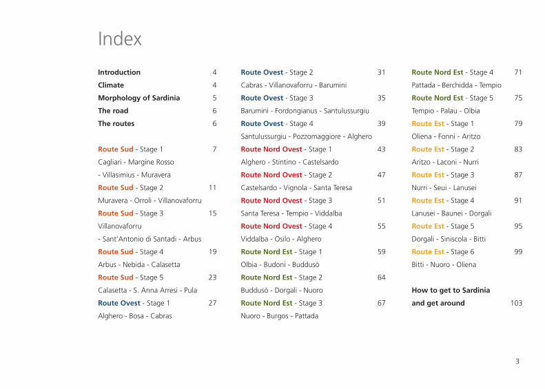
Route Nord Est - Stage 4
Pattada - Berchidda - Tempio
Route Nord Est - Stage 5
Tempio - Palau - Olbia
Route Est - Stage 1
Oliena - Fonni - Aritzo
Route Est - Stage 2
Aritzo - Laconi - Nurri
Route Est - Stage 3
Nurri - Seui - Lanusei
Route Est - Stage 4
Lanusei - Baunei - Dorgali
Route Est - Stage 5
Dorgali - Siniscola - Bitti
Route Est - Stage 6
Bitti - Nuoro - Oliena
How to get to Sardinia
and get around
Introduction
Climate
Morphology of Sardinia
The road
The routes
Route Sud - Stage 1
Cagliari - Margine Rosso
- Villasimius - Muravera
Route Sud - Stage 2
Muravera - Orroli - Villanovaforru
Route Sud - Stage 3
Villanovaforru
- Sant’Antonio di Santadi - Arbus
Route Sud - Stage 4
Arbus - Nebida - Calasetta
Route Sud - Stage 5
Calasetta - S. Anna Arresi - Pula
Route Ovest - Stage 1
Alghero - Bosa - Cabras
3
Route Ovest - Stage 2
Cabras - Villanovaforru - Barumini
Route Ovest - Stage 3
Barumini - Fordongianus - Santulussurgiu
Route Ovest - Stage 4
Santulussurgiu - Pozzomaggiore - Alghero
Route Nord Ovest - Stage 1
Alghero - Stintino - Castelsardo
Route Nord Ovest - Stage 2
Castelsardo - Vignola - Santa Teresa
Route Nord Ovest - Stage 3
Santa Teresa - Tempio - Viddalba
Route Nord Ovest - Stage 4
Viddalba - Osilo - Alghero
Route Nord Est - Stage 1
Olbia - Budoni - Buddusò
Route Nord Est - Stage 2
Buddusò - Dorgali - Nuoro
Route Nord Est - Stage 3
Nuoro - Burgos - Pattada
71
75
79
83
87
91
95
99
103
31
35
39
43
47
51
55
59
64
67
4
4
5
6
6
7
11
15
19
23
27
Index
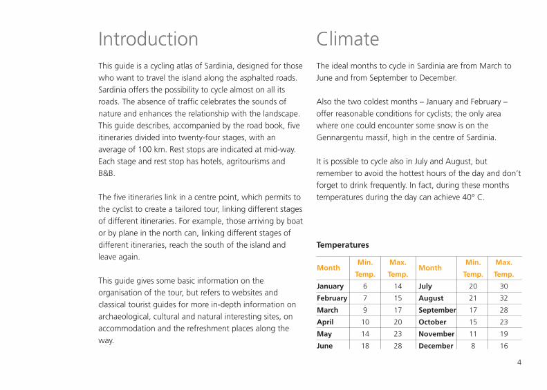
Introduction ClimateThis guide is a cycling atlas of Sardinia, designed for thosewho want to travel the island along the asphalted roads.Sardinia offers the possibility to cycle almost on all itsroads. The absence of traffic celebrates the sounds ofnature and enhances the relationship with the landscape.This guide describes, accompanied by the road book, fiveitineraries divided into twenty-four stages, with anaverage of 100 km. Rest stops are indicated at mid-way.Each stage and rest stop has hotels, agritourisms andB&B.
The five itineraries link in a centre point, which permits tothe cyclist to create a tailored tour, linking different stagesof different itineraries. For example, those arriving by boator by plane in the north can, linking different stages ofdifferent itineraries, reach the south of the island andleave again.
This guide gives some basic information on theorganisation of the tour, but refers to websites andclassical tourist guides for more in-depth information onarchaeological, cultural and natural interesting sites, onaccommodation and the refreshment places along theway.
The ideal months to cycle in Sardinia are from March toJune and from September to December.
Also the two coldest months – January and February –offer reasonable conditions for cyclists; the only areawhere one could encounter some snow is on theGennargentu massif, high in the centre of Sardinia.
It is possible to cycle also in July and August, butremember to avoid the hottest hours of the day and don’tforget to drink frequently. In fact, during these monthstemperatures during the day can achieve 40° C.
Temperatures
Month
January
February
March
April
May
June
Min.
Temp.
6
7
9
10
14
18
Max.
Temp.
14
15
17
20
23
28
Month
July
August
September
October
November
December
Min.
Temp.
20
21
17
15
11
8
Max.
Temp.
30
32
28
23
19
16
4

5
Sardinia is an Island in the Mediterranean sea with an areaof 24.040 km², 270 km of lencth and 145 km of width. Itis bigger than Corsica and smaller than Sicily. The island isan ancient land, marked by different geological eras whichhave characterized its landscapes making them extremelyvaried and morphologically different. Its inland is mainlyhilly, among its mountains, the central massif of theGennargentu stands out, and it culminates with the peakPunta La Marmora (1834 m). In the south west part of theIsland the huge plain of the Campidano goes from Cagliarito Oristano, dividing the mountain groups of the Iglesienteand Sulcis areas. The granitic massif of the Sulcis area isisolated from other formations and it is not unusual for itto reach 1000 m of height. In the South-Centre, betweenthe mountain ridges and the Campidano area, there is ahilly area with landscapes of soft undulations, in which wecan find the typical Giare (basalt plateaus), of which themain one is that of Gesturi (between 500 and 600 m ofheight). In the West-Centre, in the plain of the Oristanoarea there are the Monte Arci (812 m) and the MonteFerru (1.050 m), which join the central massifsdetermining the geographical division of the island inCapo di Sopra or Capo di Sassari (upper side) and Capo diSotto or Capo di Cagliari (lower side). In the North-West,
the volcanic formations occupy the vast majority of theterritory. In fact, the Logudoro area presents remarkabletraces of its volcanic past with small hills which emergefrom the plain with sharp profiles. The volcanic landscapeextends up to the North-West, while towards Alghero itgives space to a huge plain which overlooks the sea withstriking calcareous promontories. In the North-East, thegranite relief of the Gallura area has distinctive profilescarved by the wind through time, the highest, MonteLimbara, reaches 1.362 m of height. In the Southern partof the Gallura area, the granite has mountainous featureswith huge ridges, in a crescendo towards the peaks of theBarbagia area. In the Centre-East, aroud the gulf ofOrosei, the dolomitic limestone formations prevail andthey form the so called “Supramontes”, characterized bydizzy, bare and whitish walls which give the landscape alunar aspect. The Karst phenomenon created severalgrottoes and dolines (such as that of Tiscali). In the South-East we can find tacchi and tonneri, which are typicalcalcareous formations, sometimes shaly, whichcharacterize the land between the Flumendosa river andthe Southern border of the Ogliastra area. In the mountaingroup of the Sette Fratelli, in the South, we can find thegranite again.
Morphology of Sardinia

6
The routes use roads with a little traffic. In fact, Sardinia issparsely populated; the habitative density is about 67inhabitans per km² compared to the Italian average,which is 189 inhabitants per km².The population and the traffic are concentrated in theregion of Cagliari and around the more populated towns.The quality of the road surface is good and the roads arelarge enough to allow vehicles to overtake easily.Car drivers respect cyclists and the sound of the horn is tosay “hello”, to let you know that they are passing.
The routesThe five routes proposed have been created based on thebeauty of the places. The 24 stages which form themhave been oriented according to the prevailing wind ofthe island, the Mistral which blows from North-West.For each stage there are road books which describe theroute, road maps, the altitude profile and some infoabout the main interesting sites along the route.
The level of difficulty of the stage can be:Easy – The ground is mainly level, with drops up to 700m per 100 kmMedium – The ground is moderately hilly, with drops upto 1.200 m per 100 kmDemanding – Hilly ground, with drops up to 1.700 mper 100 kmHard - Mountainous ground, with drops exceeding1.700 m per 100 kmThe road book indicates the points to enter and leave thetowns and the direction to follow to cross them.
The following symbols are used in the road books toexplain the directions:
The following are the symbols used in the stage maps:Start of the stageHalf- stageEnd of the stage
���!
����
The roads
Start of the stageEnd of the stageGo straightTurn left
Go on keeping the leftTurn rightGo on keeping the rightPay particular attention
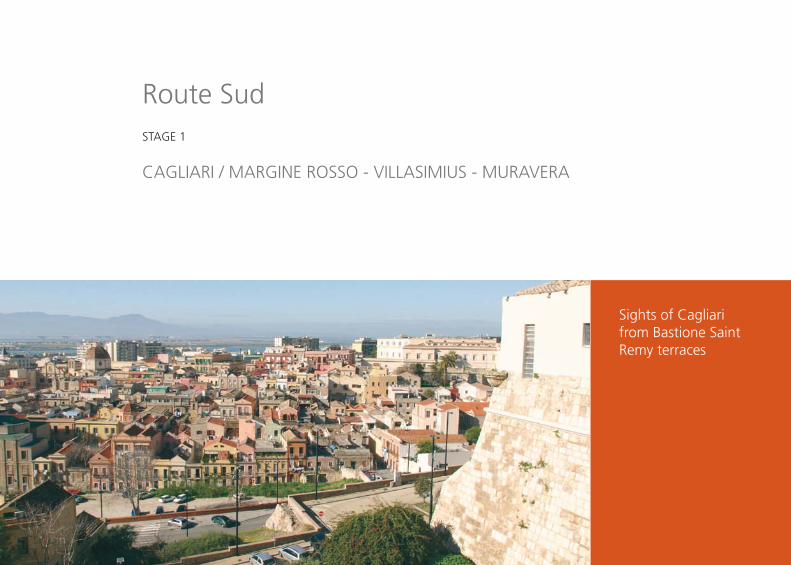
Sights of Cagliari from Bastione SaintRemy terraces
Route SudSTAGE 1
CAGLIARI / MARGINE ROSSO - VILLASIMIUS - MURAVERA

8
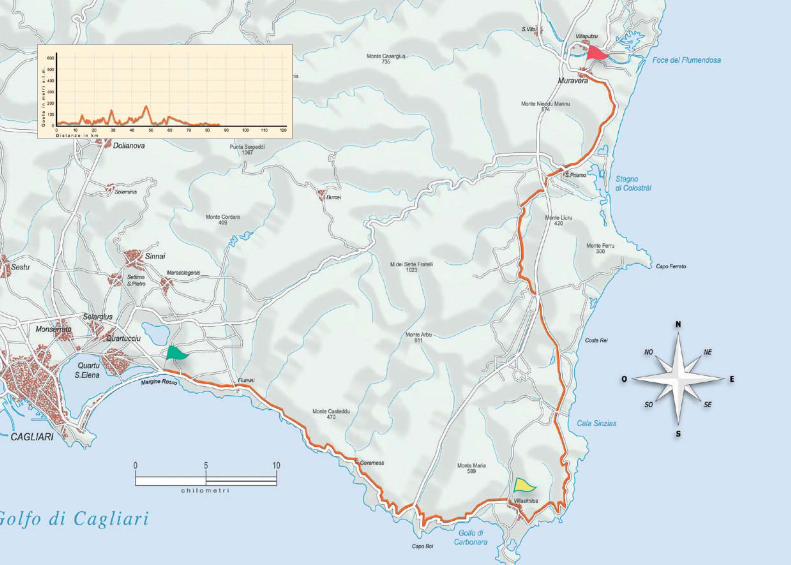
Stage 1Cagliari - Margine Rosso - Villasimius - MuraveraTot. stage Km 83,8 - Ascent stage m 810 - Tot. route Km 83,8Level of difficulty: medium
HighlightsThe ancient district of Castello in Cagliari - Landscapes alongthe coastal road The marine protected area of Villasimius
Location km Total Kms Ascent Direction
Margine Rosso roundabout 0 0 0 � (Roundabout at 12 km from Cagliari railway station) Set off towards Villasimius
Capitana junction 10,7 10,7 36 � Go on keeping the right and following the directions towards Villasimius
Geremeas 6,3 17 156 � Go straight on
Torre delle Stelle 3,5 20,5 184 � Go straight on
Solanas 4,4 24,9 266 � Go straight on
Villasimius 4,1 29 410 � Enter the territory of Villasimius
Villasimius petrol station 7,5 36,5 428 � Go on keeping the left
Crossroads 0,5 37 433 � Turn left towards Castiadas
Roundabout 0,9 37,9 450 � Turn right towards Villasimius
Crossroads 2,7 40,6 480 � Go straight on
Crossroads 12,4 53 647 � Go straight on towards Muravera
Costa Rei crossroads 2,2 55,2 660 � Go on keeping the left and staying on the main road
Capo Ferrato crossroads 7,8 63 657 � Turn left towards San Priamo - Muravera
First Olia Speciosa crossroads 0,6 63,6 759 � Turn right towards San Priamo - Muravera
Second Olia Speciosa crossroads 0,4 64 759 � Go straight on towards San Priamo, also at the next crossroads
Camisa crossroads 1,7 65,7 763 � Go on keeping the left towards San Priamo
Crossroads 9,3 75 772 � Get onto the main road towards Muravera (SS 125)
Muravera (football field) 8,8 83,8 810 � Muravera entrance


Su Nuraxi, Barumini
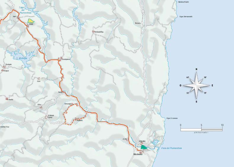
Route SudSTAGE 2
MURAVERA - ORROLI - VILLANOVAFORRU

12
Stage 2Muravera - Orroli - VillanovaforruTot. stage Km 107,5 - Ascent stage m 1519 - Tot. route Km 191,3Level of difficulty: demanding
HighlightsFlumendosa lakeThe Nuraghes of Orroli and Barumini
Location km Total Kms Ascent Direction
Muravera - football field exit 0 0 0 � Set off from Muravera towards San Vito
San Vito crossroads 2,5 2,5 10 � At the exit of the village turn left towards San Vito
Ponte San Vito (bridge) 2,25 4,75 15 � Cross the village
First tunnel 15,55 20,3 28 � Tunnel lower than 500m
Villassalto crossing 0,7 21 100 � Go straight on ! To avoid the tunnels detour towards Villasalto-Armungia
Armungia crossing 5,4 26,4 124 � Go straight on
Ballao entrance 3,2 29,6 250 � Cross the village towards Escalaplano
Escalaplano 12,8 42,4 400 � Turn left towards Orroli
Escalaplano exit 1,3 43,7 592 � Go on keeping the left in the descent road towards Orroli
Nuraghe Arrubiu crossing 8,3 52 904 � Note: turn left to visit the Nuraghe Arrubiu
Orroli entrance 7,4 59,4 1026 � Cross the village towards Nurri
Nurri exit 5 64,4 1100 � Cross the village and at the exit keep the left
Crossroads after the industrial area 2,2 66,6 1109 � Turn left towards Isili SP 128
Mandas crossroads 7,4 74 1200 � Turn left towards Mandas - Cagliari
Escolca crossroads 1 75 1230 � Turn right towards Escolca - Gerrei
Escolca entrance 2,2 77,2 1231 � Cross the village towards Gergei - Barumini
Barumini entrance 12,8 90 1280 � Go straight on also at the next crossroads following the directions for Tuili
Su Nuraxi 1,6 91,6 1337 � Go straight on
Tuili exit 3,1 94,7 1350 � Cross the village and at the exit turn left towards Pauli Arbarei
Pauli Arbarei 5,8 100,5 1373 � Cross the village towards Lunamatrona
Lunamatrona entrance 3 103,5 1405 � Cross the village towards Villanovaforru
Villanovaforru entrance 4 107,5 1519 � Turn left and enter Villanovaforru


Monte ArcuentuProfile
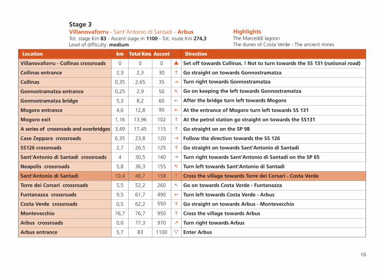
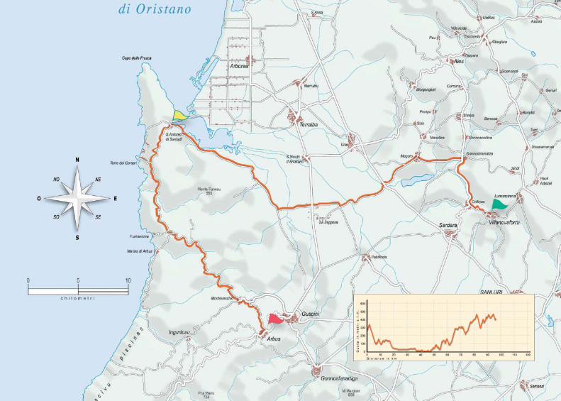
Route SudSTAGE 3
VILLANOVAFORRU - SANT’ANTONIO DI SANTADI - ARBUS
16
Stage 3Villanovaforru - Sant’Antonio di Santadi - ArbusTot. stage Km 83 - Ascent stage m 1100 - Tot. route Km 274,3Level of difficulty: medium
HighlightsThe Marceddì lagoonThe dunes of Costa Verde - The ancient mines
Location km Total Kms Ascent Direction
Villanovaforru - Collinas crossroads 0 0 0 � Set off towards Collinas. ! Not to turn towards the SS 131 (national road)
Collinas entrance 2,3 2,3 30 � Go straight on towards Gonnostramatza
Collinas 0,35 2,65 35 � Turn right towards Gonnostramatza
Gonnostramatza entrance 0,25 2,9 50 � Go on keeping the left towards Gonnostramatza
Gonnostramatza bridge 5,3 8,2 60 � After the bridge turn left towards Mogoro
Mogoro entrance 4,6 12,8 90 � At the entrance of Mogoro turn left towards SS 131
Mogoro exit 1,16 13,96 102 � At the petrol station go straight on towards the SS131
A series of crossroads and overbridges 3,49 17,45 115 � Go straight on on the SP 98
Case Zeppara crossroads 6,35 23,8 120 � Follow the direction towards the SS 126
SS126 crossroads 2,7 26,5 125 � Go straight on towards Sant'Antonio di Santadi
Sant'Antonio di Santadi crossroads 4 30,5 140 � Turn right towards Sant'Antonio di Santadi on the SP 65
Neapolis crossroads 5,8 36,3 155 � Turn left towards Sant'Antonio di Santadi
Sant'Antonio di Santadi 10,4 46,7 158 � Cross the village towards Torre dei Corsari - Costa Verde
Torre dei Corsari crossroads 5,5 52,2 260 � Go on towards Costa Verde - Funtanazza
Funtanazza crossroads 9,5 61,7 490 � Turn left towards Costa Verde - Arbus
Costa Verde crossroads 0,5 62,2 550 � Go straight on towards Arbus - Montevecchio
Montevecchio 76,7 76,7 950 � Cross the village towards Arbus
Arbus crossroads 0,6 77,3 970 � Turn right towards Arbus
Arbus entrance 5,7 83 1100 � Enter Arbus


Pan di Zucchero cliffs,Nebida
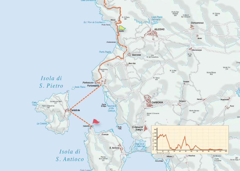
Route SudSTAGE 4
ARBUS - NEBIDA - CALASETTA

20
Stage 4Arbus - Nebida - CalasettaTot. stage Km 71,8 - Ascent stage m 1700 - Tot. route Km 346,1Level of difficulty: demanding
HighlightsThe coastal road - Portixeddu and Cala Domestica beachesThe Pan di Zucchero rock - Carloforte
Location km Total Kms Ascent Direction
Arbus - SS126 exit 0 0 0 � Set off towards Fluminimaggiore on the SS 126
Piscinas crossroads 9 9 120 � Go straight on towards Buggerru - Fluminimaggiore
Portixeddu crossroads 9,3 18,3 200 � Turn right towards Portixeddu - Buggerru
Buggerru crossroads 12,3 30,6 320 � Cross Buggerru towards Cala Domestica
Masua crossroads 15,6 46,2 1150 � Turn left towards Nebida
Nebida 1 47,2 1350 � Go straight on towards Funtanamare - Iglesias
National crossroads 8,3 55,5 1410 � Turn right on the SS 126 (possible traffic)
Portovesme crossroads 2,8 58,3 1650 � Turn right towards the coast road for Portovesme
Portoscuso crossroads 10,2 68,5 1670 � Before the industrial area turn right towards Portoscuso
Portoscuso 1,5 70 1680 � Cross Portoscuso and get to the embarkation of Portovesme
Carloforte 1,8 71,8 1700 � Disembark at Carloforte (possible salt pits loop - Punta delle Colonne)
Calasetta 0 71,8 1700 � Disembark at Calasetta. End of the stage


Nora phoenician town, Pula
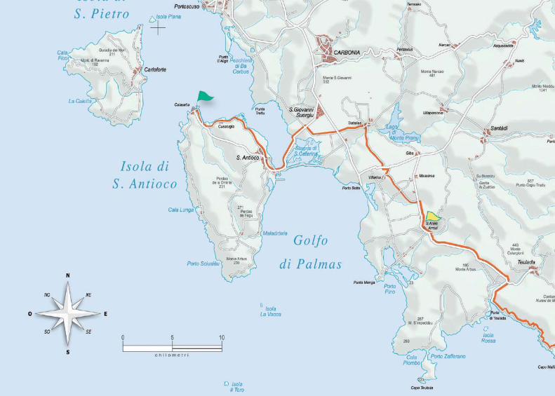
Route SudSTAGE 5
CALASETTA - S. ANNA ARRESI - PULA
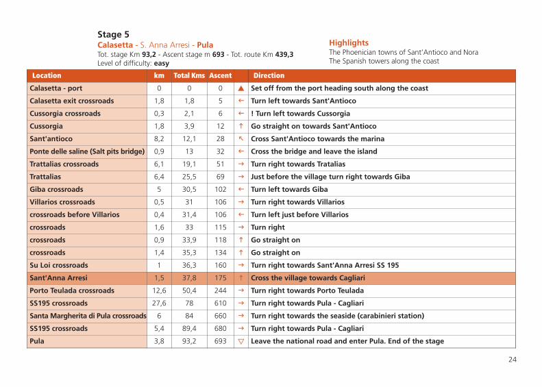
24
Stage 5Calasetta - S. Anna Arresi - PulaTot. stage Km 93,2 - Ascent stage m 693 - Tot. route Km 439,3Level of difficulty: easy
HighlightsThe Phoenician towns of Sant’Antioco and NoraThe Spanish towers along the coast
Location km Total Kms Ascent Direction
Calasetta - port 0 0 0 � Set off from the port heading south along the coast
Calasetta exit crossroads 1,8 1,8 5 � Turn left towards Sant'Antioco
Cussorgia crossroads 0,3 2,1 6 � ! Turn left towards Cussorgia
Cussorgia 1,8 3,9 12 � Go straight on towards Sant'Antioco
Sant'antioco 8,2 12,1 28 � Cross Sant'Antioco towards the marina
Ponte delle saline (Salt pits bridge) 0,9 13 32 � Cross the bridge and leave the island
Trattalias crossroads 6,1 19,1 51 � Turn right towards Tratalias
Trattalias 6,4 25,5 69 � Just before the village turn right towards Giba
Giba crossroads 5 30,5 102 � Turn left towards Giba
Villarios crossroads 0,5 31 106 � Turn right towards Villarios
crossroads before Villarios 0,4 31,4 106 � Turn left just before Villarios
crossroads 1,6 33 115 � Turn right
crossroads 0,9 33,9 118 � Go straight on
crossroads 1,4 35,3 134 � Go straight on
Su Loi crossroads 1 36,3 160 � Turn right towards Sant'Anna Arresi SS 195
Sant'Anna Arresi 1,5 37,8 175 � Cross the village towards Cagliari
Porto Teulada crossroads 12,6 50,4 244 � Turn right towards Porto Teulada
SS195 crossroads 27,6 78 610 � Turn right towards Pula - Cagliari
Santa Margherita di Pula crossroads 6 84 660 � Turn right towards the seaside (carabinieri station)
SS195 crossroads 5,4 89,4 680 � Turn right towards Pula - Cagliari
Pula 3,8 93,2 693 � Leave the national road and enter Pula. End of the stage


Montiferru landscape
Route OvestSTAGE 1
ALGHERO - BOSA - CABRAS

28
Stage 1Alghero - Bosa - CabrasTot. stage Km 109,8 - Ascent stage m 2061 - Tot. route Km 109,8Level of difficulty: hard
HighlightsAncient districts in Alghero and BosaThe coastal road and Cape Marrargiu
Location km Total Kms Ascent Direction
Alghero - Bosa exit 0 0 0 � Set off from the Alghero exit towards Bosa
Villanova crossing 13 13 220 � go straight on towards Bosa
Nuraghe Appiu crossing 6,6 19,6 490 � go straight on towards Bosa
Bosa 22,5 42,1 910 � At the roundabout go straight on over the bridge
Bridge 0,4 42,5 916 � After the bridge turn right towards Bosa marinas
Bosa Marina 0,3 42,8 918 � Cross Bosa marina following the seaside towards Turas
Turas crossing 2,7 45,5 918 � Go straight on towards Modolo
Modolo crossing 2,3 47,8 1008 � Go on keeping the right towards Modolo
Modolo 1,4 49,2 1080 � Cross the village towards Magomadas
Magomadas entrance 3,4 52,6 1260 � Turn left and cross the village towards Flussio
Flussio 1,7 54,3 1359 � Go on towards Tinnura
Sagama crossing 1,1 55,4 1355 � Turn right towards Sagama
Sagama 2,9 58,3 1372 � Go on towards Scano Montiferru
Sant'Antioco crossing 4,15 62,45 1470 � Go on towards Scano Montiferru
San Leonardo crossing 2,15 64,6 1517 � Go on towards Scano Montiferru
Scano Montiferru 0,7 65,3 1526 � Cross the village towards Cuglieri
Cuglieri crossing 5,7 71 1769 � Go on keeping the left towards Cuglieri
Cuglieri 1 72 1829 � Cross the village towards Oristano - Santa Caterina di Pittinuri
Santa Caterina di Pittinuri 12,3 84,3 1881 � Go straight on towards Oristano
Riola Sardo 17,5 101,8 2061 � After the bridge of Riola turn right and go on towards Cabras
Cabras 8 109,8 2061 � End of the stage


Nuraghe San Giovanni,Villaurbana
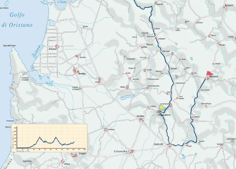
Route OvestSTAGE 2
CABRAS - VILLANOVAFORRU - BARUMINI
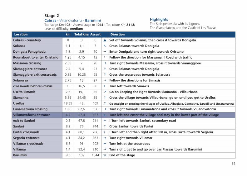
32
Stage 2Cabras - Villanovaforru - BaruminiTot. stage Km 102 - Ascent stage m 1044 - Tot. route Km 211,8Level of difficulty: medium
HighlightsThe Sinis peninsula with its lagoonsThe Giara plateau and the Castle of Las Plassas
Location km Total Kms Ascent Direction
Cabras - cemetery 0 0 0 � Set off towards Solanas, then cross it towards Donigala
Solanas 1,1 1,1 3 � Cross Solanas towards Donigala
Donigala Fenughedu 1,8 2,9 10 � Enter Donigala and turn right towards Oristano
Rounabout to enter Oristano 1,25 4,15 13 � Follow the direction for Massama. ! Road with traffic
Massama crossing 2,85 7 20 � Turn right towards Massama, cross it towards Siamaggiore
Siamaggiore entrance 2,4 9,4 23 � Cross Solanas towards Donigala
Siamaggiore exit crossroads 0,85 10,25 25 � Cross the crossroads towards Solarussa
Solarussa 2,75 13 27 � Follow the directions for Simaxis
crossroads beforeSimaxis 3,5 16,5 30 � Turn left towards Simaxis
Uscita Simaxis 2,6 19,1 35 � Go on keeping the right towards Siamanna - Villaurbana
Siamanna 5,35 24,45 35 � Cross the village towards Villaurbana, go on until you get to Usellus
Usellus 18,55 43 409 � Go straight on crossing the villages of Usellus, Albagiara, Gonnosnò, Baradili and Ussaramanna
Lunamatrona crossing 19,6 62,6 556 � Turn right towards Lunamatrona and cross it towards Villanovaforru
Villanovaforru entrance 4,7 67,3 687 � Turn left and enter the village and stay in the lower part of the village
exit to Sanluri 0,5 67,8 711 � ! Turn left towards Sanluri, secondary road
Sanluri 8,2 76 744 � Cross Sanluri towards Furtei
Furtei crossroads 4,1 80,1 786 � ! Turn left and then right after 600 m, cross Furtei towards Segariu
Segariu entrance 4,1 84,2 863 � Turn right towards Villamar
Villamar crossroads 6,8 91 902 � Turn left at the crossroads
Villamar 1,4 92,4 910 � Turn right, get to and go over Las Plassas towards Barumini
Barumini 9,6 102 1044 � End of the stage

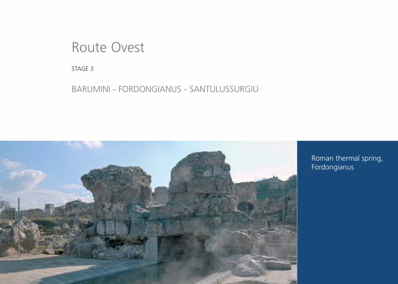
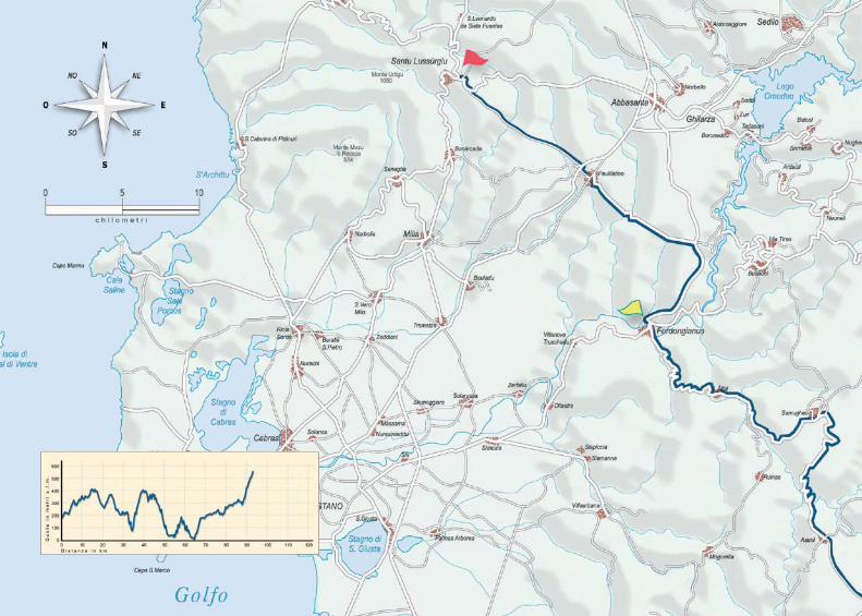
Route OvestSTAGE 3
BARUMINI - FORDONGIANUS - SANTULUSSURGIU
Roman thermal spring,Fordongianus
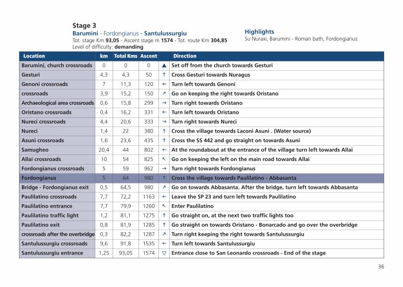
36
Stage 3Barumini - Fordongianus - SantulussurgiuTot. stage Km 93,05 - Ascent stage m 1574 - Tot. route Km 304,85Level of difficulty: demanding
HighlightsSu Nuraxi, Barumini - Roman bath, Fordongianus
Location km Total Kms Ascent Direction
Barumini, church crossroads 0 0 0 � Set off from the church towards Gesturi
Gesturi 4,3 4,3 50 � Cross Gesturi towards Nuragus
Genoni crossroads 7 11,3 120 � Turn left towards Genoni
crossroads 3,9 15,2 150 � Go on keeping the right towards Oristano
Archaeological area crossroads 0,6 15,8 299 � Turn right towards Oristano
Oristano crossroads 0,4 16,2 331 � Turn left towards Oristano
Nureci crossroads 4,4 20,6 333 � Turn right towards Nureci
Nureci 1,4 22 380 � Cross the village towards Laconi Asuni . (Water source)
Asuni crossroads 1,6 23,6 435 � Cross the SS 442 and go straight on towards Asuni
Samugheo 20,4 44 802 � At the roundabout at the entrance of the village turn left towards Allai
Allai crossroads 10 54 825 � Go on keeping the left on the main road towards Allai
Fordongianus crossroads 5 59 962 � Turn right towards Fordongianus
Fordongianus 5 64 980 � Cross the village towards Paulilatino - Abbasanta
Bridge - Fordongianus exit 0,5 64,5 980 � Go on towards Abbasanta. After the bridge, turn left towards Abbasanta
Paulilatino crossroads 7,7 72,2 1163 � Leave the SP 23 and turn left towards Paulilatino
Paulilatino entrance 7,7 79,9 1260 � Enter Paulilatino
Paulilatino traffic light 1,2 81,1 1275 � Go straight on, at the next two traffic lights too
Paulilatino exit 0,8 81,9 1285 � Go straight on towards Oristano - Bonarcado and go over the overbridge
crossroads after the overbridge 0,3 82,2 1287 � Turn right keeping the right towards Santulussurgiu
Santulussurgiu crossroads 9,6 91,8 1535 � Turn left towards Santulussurgiu
Santulussurgiu entrance 1,25 93,05 1574 � Entrance close to San Leonardo crossroads - End of the stage


Monteleone Rocca Doria
Route OvestSTAGE 4
SANTULUSSURGIU - POZZOMAGGIORE - ALGHERO

40
Stage 4Santulussurgiu - Pozzomaggiore - AlgheroTot. stage Km 96 - Ascent stage m 1314 - Tot. route Km 400,85Level of difficulty: demanding
HighlightsThe Montiferru forests - The Monteleone Roccadoria peak The lake Temo
Location km Total Kms Ascent Direction
Santulussurgiu 0 0 0 � Set off from the exit for San Leonardo towards San Leonardo
San Leonardo crossroads 4,2 4,2 192 � Turn right towards San Leonardo
San Leonardo 1,6 5,8 193 � go straight on. (Water source)
Monte Sant'Antonio crossroads 8,9 14,7 232 � Turn left towards Monte Sant'Antonio - Tombe dei Giganti Tamuli
crossroads 0,9 15,6 283 � Go on keeping the left towards Monte Sant'Antonio
Fork 1,55 17,15 323 � Leave the main road and go on keeping the right
crossroads 2,65 19,8 324 � Turn right! Read what follows
crossroads 0 19,8 324 � Turn left after 30 m from the previous point
Junction before Sindia 3,1 22,9 325 � Go straight on passing under the bridge and enter Sindia
Sindia exit for Macomer 1,9 24,8 355 � Cross the village towards Macomer. (Water source)
crossroads for the holiday farm 1,4 26,2 390 � Turn left towards Agriturismo Nuraghe Elighe (holiday farm)
Junction 2,8 29 415 � Go on keeping the left follow the descending road
Junction 2,6 31,6 424 � Turn left on the main road
Pozzomaggiore crossroads 9,4 41 482 � Turn left follow the ascent towards Pozzomaggiore
Pozzomaggiore crossroads 2,4 43,4 579 � Turn left on the SS 292 towards Padria
Padria crossroads 3,1 46,5 587 � Turn right on the SS 292 towards Padria - Alghero. Stay on this road until Alghero
Padria entrance 0,6 47,1 587 � Cross the village towards Villanova Monteleone - Alghero. (Water source)
Villanova Monteleone entrance 26 73,1 1095 � Cross the village towards Alghero. (Water source)
Villanova Monteleone exit 1,9 75 1162 � Go straight on the SS 292 until Alghero.
Alghero litoranea - Bosa crossroads 5 80 1186 � Go straight on the descent on the SS 292
Alghero entrance 16 96 1314 � End of the stage


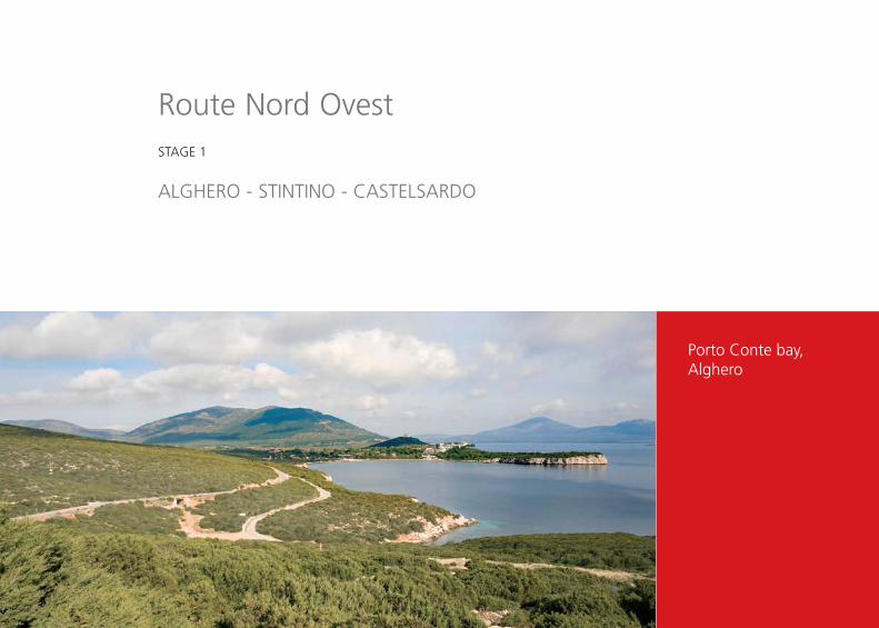
Porto Conte bay,Alghero
Route Nord OvestSTAGE 1
ALGHERO - STINTINO - CASTELSARDO
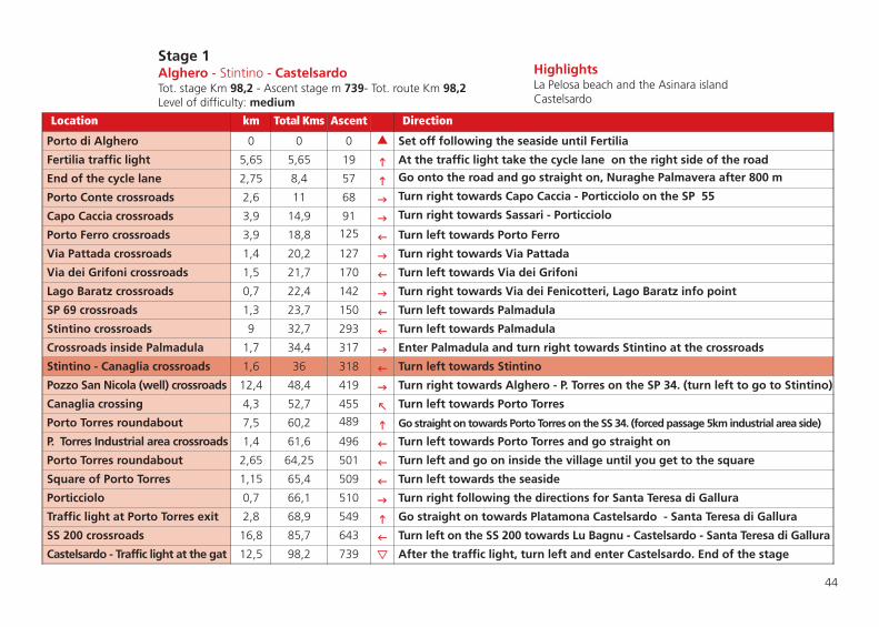
44
Stage 1Alghero - Stintino - CastelsardoTot. stage Km 98,2 - Ascent stage m 739- Tot. route Km 98,2Level of difficulty: medium
Location km Total Kms Ascent Direction
Porto di Alghero 0 0 0 � Set off following the seaside until Fertilia
Fertilia traffic light 5,65 5,65 19 � At the traffic light take the cycle lane on the right side of the road
End of the cycle lane 2,75 8,4 57 � Go onto the road and go straight on, Nuraghe Palmavera after 800 m
Porto Conte crossroads 2,6 11 68 � Turn right towards Capo Caccia - Porticciolo on the SP 55
Capo Caccia crossroads 3,9 14,9 91 � Turn right towards Sassari - Porticciolo
Porto Ferro crossroads 3,9 18,8 125 � Turn left towards Porto Ferro
Via Pattada crossroads 1,4 20,2 127 � Turn right towards Via Pattada
Via dei Grifoni crossroads 1,5 21,7 170 � Turn left towards Via dei Grifoni
Lago Baratz crossroads 0,7 22,4 142 � Turn right towards Via dei Fenicotteri, Lago Baratz info point
SP 69 crossroads 1,3 23,7 150 � Turn left towards Palmadula
Stintino crossroads 9 32,7 293 � Turn left towards Palmadula
Crossroads inside Palmadula 1,7 34,4 317 � Enter Palmadula and turn right towards Stintino at the crossroads
Stintino - Canaglia crossroads 1,6 36 318 � Turn left towards Stintino
Pozzo San Nicola (well) crossroads 12,4 48,4 419 � Turn right towards Alghero - P. Torres on the SP 34. (turn left to go to Stintino)
Canaglia crossing 4,3 52,7 455 � Turn left towards Porto Torres
Porto Torres roundabout 7,5 60,2 489 � Go straight on towards Porto Torres on the SS 34. (forced passage 5km industrial area side)
P. Torres Industrial area crossroads 1,4 61,6 496 � Turn left towards Porto Torres and go straight on
Porto Torres roundabout 2,65 64,25 501 � Turn left and go on inside the village until you get to the square
Square of Porto Torres 1,15 65,4 509 � Turn left towards the seaside
Porticciolo 0,7 66,1 510 � Turn right following the directions for Santa Teresa di Gallura
Traffic light at Porto Torres exit 2,8 68,9 549 � Go straight on towards Platamona Castelsardo - Santa Teresa di Gallura
SS 200 crossroads 16,8 85,7 643 � Turn left on the SS 200 towards Lu Bagnu - Castelsardo - Santa Teresa di Gallura
Castelsardo - Traffic light at the gat 12,5 98,2 739 � After the traffic light, turn left and enter Castelsardo. End of the stage
HighlightsLa Pelosa beach and the Asinara islandCastelsardo


Castelsardo
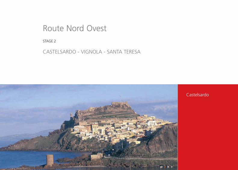
Route Nord OvestSTAGE 2
CASTELSARDO - VIGNOLA - SANTA TERESA
48
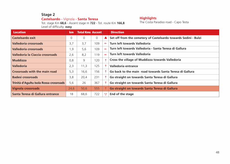
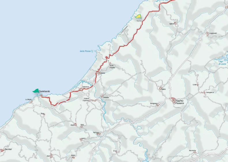
Stage 2Castelsardo - Vignola - Santa TeresaTot. stage Km 68,6 - Ascent stage m 722 - Tot. route Km 166,8Level of difficulty: easy
HighlightsThe Costa Paradiso road - Capo Testa
Location km Total Kms Ascent Direction
Castelsardo exit 0 0 0 � Set off from the cemetery of Castelsardo towards Sedini - Bulzi
Valledoria crossroads 3,7 3,7 109 � Turn left towards Valledoria
Valledoria crossroads 1,9 5,6 109 � Turn left towards Valledoria - Santa Teresa di Gallura
Valledoria la Ciaccia crossroads 2,6 8,2 119 � Turn left towards Valledoria
Muddizza 0,8 9 120 � Cross the village of Muddizza towards Valledoria
Valledoria 2,3 11,3 125 � Valledoria entrance
Crossroads with the main road 5,3 16,6 156 � Go back to the main road towards Santa Teresa di Gallura
Badesi crossroads 3,8 20,4 231 � Go straight on towards Santa Teresa di Gallura
Trinità d'Agultu Isola Rossa crossroads 5,6 26 367 � Go straight on towards Santa Teresa di Gallura
Vignola crossroads 24,6 50,6 555 � Go straight on towards Santa Teresa di Gallura
Santa Teresa di Gallura entrance 18 68,6 722 � End of the stage

The Moon valley,Aggius
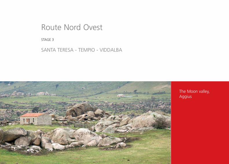
Route Nord OvestSTAGE 3
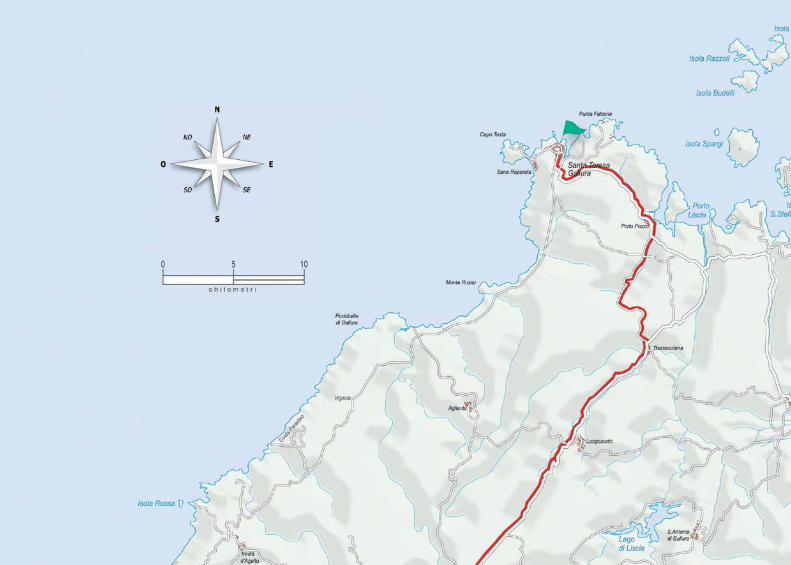
SANTA TERESA - TEMPIO - VIDDALBA
52
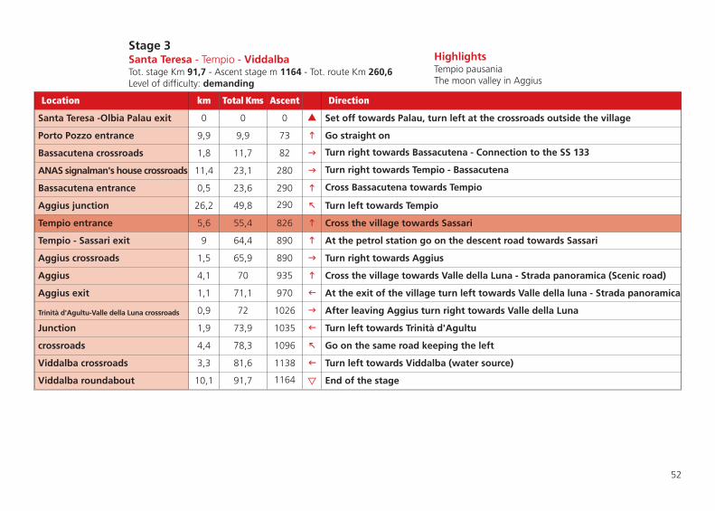
Stage 3Santa Teresa - Tempio - ViddalbaTot. stage Km 91,7 - Ascent stage m 1164 - Tot. route Km 260,6Level of difficulty: demanding
HighlightsTempio pausaniaThe moon valley in Aggius
Location km Total Kms Ascent Direction
Santa Teresa -Olbia Palau exit 0 0 0 � Set off towards Palau, turn left at the crossroads outside the village
Porto Pozzo entrance 9,9 9,9 73 � Go straight on
Bassacutena crossroads 1,8 11,7 82 � Turn right towards Bassacutena - Connection to the SS 133
ANAS signalman's house crossroads 11,4 23,1 280 � Turn right towards Tempio - Bassacutena
Bassacutena entrance 0,5 23,6 290 � Cross Bassacutena towards Tempio
Aggius junction 26,2 49,8 290 � Turn left towards Tempio
Tempio entrance 5,6 55,4 826 � Cross the village towards Sassari
Tempio - Sassari exit 9 64,4 890 � At the petrol station go on the descent road towards Sassari
Aggius crossroads 1,5 65,9 890 � Turn right towards Aggius
Aggius 4,1 70 935 � Cross the village towards Valle della Luna - Strada panoramica (Scenic road)
Aggius exit 1,1 71,1 970 � At the exit of the village turn left towards Valle della luna - Strada panoramica
Trinità d'Agultu-Valle della Luna crossroads 0,9 72 1026 � After leaving Aggius turn right towards Valle della Luna
Junction 1,9 73,9 1035 � Turn left towards Trinità d'Agultu
crossroads 4,4 78,3 1096 � Go on the same road keeping the left
Viddalba crossroads 3,3 81,6 1138 � Turn left towards Viddalba (water source)
Viddalba roundabout 10,1 91,7 1164 � End of the stage

Alghero
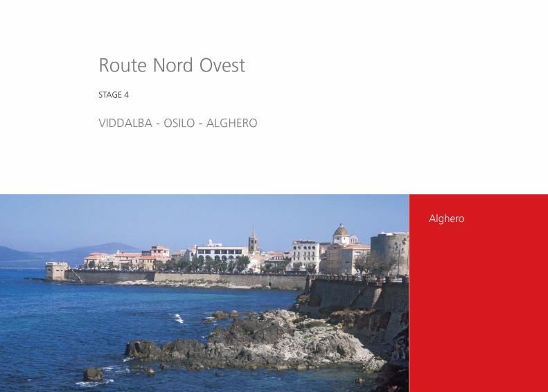
Route Nord OvestSTAGE 4
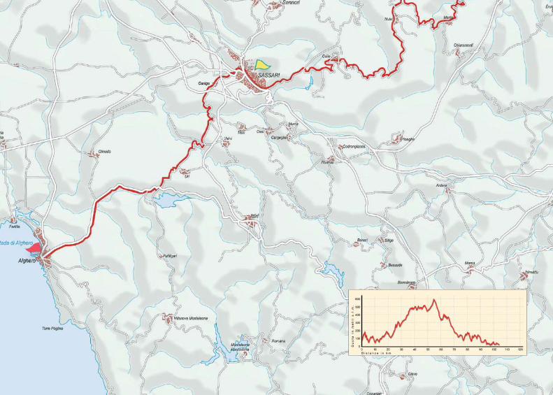
VIDDALBA - OSILO - ALGHERO

56
Stage 4Viddalba - Osilo - AlgheroTot. stage Km 101,6 - Ascent stage m 1319 - Tot. route Km 362,2Level of difficulty: demanding
HighlightsGoceano countrysideAlghero ancient districts - Capo Caccia cliffs
Location km Total Kms Ascent Direction
Roundabout - Viddalba exit 0 0 0 � Set off passing the bridge towards Santa Maria Coghinas
Santa Maria Coghinas 1,2 1,2 0 � Go on towards Perfugas
SS 127 crossroads 10,4 11,6 227 � Turn right towards Perfugas
Perfugas 1 12,6 257 � Cross Perfugas towards Laerru - Martis
Laerru 6,7 19,3 375 � Cross the village towards Martis
Martis 8,3 27,6 557 � Cross the village towards Nulvi - Osilo - Sassari
Martis exit 1 28,6 557 � Go on the main road (not towards Ozieri)
Castelsardo crossroads 8 36,6 609 � Go straight on towards Nulvi
Nulvi 1,5 38,1 669 � Cross the village towards Osilo
Chiaramonti crossroads 5 43,1 699 � Go straight on towards Osilo
Osilo 13,5 56,6 909 � Cross the village following the main road towards Sassari old road
Osilo crossroads (new road) 9,5 66,1 1049 � Go on keeping the left towards Sassari
Sassari, entrance from Serra Secca 2,5 68,6 1049 � The distance in kilometers starts again at the exit of the town.
Sassari, piazza Santa Maria 0 68,6 1049 � Set off towards Alghero through the underpass
Caniga crossroads 0,5 69,1 1049 � Take the second road on the left after the underpass towards Caniga - Usini - Uri
Porto Torres crossroads 0,5 69,6 1049 � Go straight on also at the next crossroads
Caniga crossroads 1,1 70,7 1055 � Go straight on towards Usini - Uri
Alghero - Porto Torres crossroads 0,8 71,5 1079 � Go straight on towards Usini - Uri
Uri crossroads 12,3 83,8 1265 � Go straight on at both crossroads towards Alghero
Olmedo crossroads 10,6 94,4 1299 � Go straight on towards Alghero
Alghero entrance 7,2 101,6 1319 � End of the stage


Flamingosnear San Teodoro
Route Nord EstSTAGE 1
OLBIA - BUDONI - BUDDUSÒ

60
Stage 1Olbia - Budoni - BuddusòTot. stage Km 92 - Ascent stage m 1430 - Tot. route Km 92Level of difficulty: demanding
HighlightsTavolara islandGranite in Buddusò
Location km Total Kms Ascent Direction
Olbia - Porto San Paolo crossroads 0 0 0 � Set off from the huge rotonda towards Porto San Paolo
Roundabout 6,6 6,6 37 � Go straight on for Porto San Paolo
San Paolo port 3,4 10 80 � Go straight on
Capo Coda Cavallo 6,7 16,7 132 � Go straight on
Padru crossroads 6 22,7 154 � Go straight on
San Teodoro crossroads 0,5 23,2 161 � Go straight on for Budoni
Agrustos crossroads 8,7 31,9 250 � Go straight on
Roundabout Budoni exit 0,9 32,8 252 � Turn right for Talavà passing under the overbridge
Brunella crossroads 6,2 39 424 � Turn right to Talavà-Lago Posada
Talavà 1,2 40,2 475 � Go straight on for Lago Posada
Torpè crossing 5,1 45,3 479 � Go straight on for Diga Concas
Second Torpè crossing 1,7 47 507 � Go on keeping the right for Alà dei Sardi
Crossing on the right 3 50 690 � Go straight on along the same road. (Water source at km 67)
Monti - Padru crossroads 19 69 1108 � Go straight on for Alà dei Sardi
Sonorcolos crossing 6,6 75,6 1230 � Go straight on for Alà dei Sardi
Alà dei Sardi crossing 3,8 79,4 1290 � Turn left for Alà dei Sardi
Alà dei Sardi 1,4 80,8 1357 � Cross the village towards Buddusò
Buddusò 11,2 92 1430 � Enter Buddusò - End of the stage


Oliena and the Corrasimountain
Route Nord EstSTAGE 2
BUDDUSÒ - DORGALI - NUORO

64
Stage 2Buddusò - Dorgali - NuoroTot. stage Km 87,2 - Ascent stage m 1240 - Tot. route Km 179,2Level of difficulty: demanding
HighlightsOliena and dorgali valleysSupramonte range - Museums of Nuoro
Location km Total Kms Ascent Direction
Buddusò - Nuoro Bitti exit 0 0 0 � Set off towards Nuoro
Osidda crossing 18,4 18,4 205 � Go straight on
Nule crossing 0,5 18,9 206 � Go on keeping the left for Bitti
Bitti - Lula crossroads 3,7 22,6 207 � Turn left for Lula and cross Bitti towards Onanì
Crossroads 2,4 25 243 � Turn right in descent! Read the following point
Onanì crossing 0,1 25,1 243 � Turn left for Onanì - Lula
Onanì entrance 6,1 31,2 270 � Go straight on for Lula
Lula entrance 5 36,2 368 � Cross the village towards Nuoro
Crossroads after the overbridge 16 52,2 520 � Go straight on for Oliena
Dorgali crossroads 7,5 59,7 700 � Go straight on for Dorgali
“Su Gologone” crossroads 5,2 64,9 729 � Turn right for Oliena
Oliena entrance 12,3 77,2 944 � Cross the village towards Nuoro
Nuoro - Orgosolo crossroads 8,4 85,6 1113 � Turn right for Nuoro
Nuoro entrance 1,6 87,2 1240 � End of the stage


Burgos and its castle
Route Nord EstSTAGE 3
NUORO - BURGOS - PATTADA

68
Stage 3Nuoro - Burgos - PattadaTot. stage Km 87,3 - Ascent stage m 1684 - Tot. route Km 266,5Level of difficulty: hard
HighlightsForest and Castle in BurgosTraditional Knives in Pattada
Location km Total Kms Ascent Direction
Nuoro 0 0 0 � Set off from crossroad between viale murighessa-viale resistenza and leave Nuoro
Crossroads with the SS 131DCN 11 11 33 � Go straight on, also at the crossroad after the overbridge
S’Inforcau bar crossroad 2 13 50 � Leave the main road and turn right towards Nuraghe Brodu
Holiday farm crossroads 9,3 22,3 330 � Turn left
Nuoro - Bono crossroads 3,2 25,5 330 � Turn left towards Bono
crossroads 9,8 35,3 470 � Turn left for Bottida at the crossroads with no signs
Junction 3,4 38,7 470 � Turn right towards Bottida - Burgos
Olbia crossroads 0,5 39,2 500 � Go straight on for Burgos
Bottida 3,8 43 666 � Cross the village towards Burgos
Burgos crossroads 2,3 45,3 761 � Turn right for Burgos
Burgos 1 46,3 820 � Cross the village towards Foresta Burgos
Bono - Anela crossroads 2,4 48,7 962 � Turn right towards Bono
First Bono crossroads 1,5 50,2 962 � Turn left towards via Veneto
Bono entrance 1,1 51,3 1024 � Turn left towards Circonvallazione Nord and leave for Anela
Anela 6,1 57,4 1072 � Cross the village towards Bultei
Bultei 2,8 60,2 1116 � Go straight on towards Pattada
Benetutti - Nule crossroads 8,6 68,8 1160 � Go straight on towards Pattada
Olbia Buddusò crossroads 8,3 77,1 1421 � Go straight on towards Pattada
Olbia Buddusò crossroads 5,3 82,4 1519 � Go straight on towards Pattada
Pattada crossroads 1,7 84,1 1520 � Turn right towards Pattada
Pattada 3,2 87,3 1684 � End of the stage

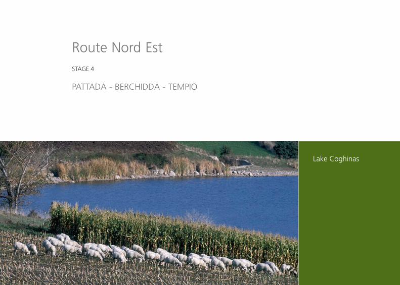
Lake Coghinas
Route Nord EstSTAGE 4
PATTADA - BERCHIDDA - TEMPIO

72
Stage 4Pattada - Berchidda - TempioTot. stage Km 67 - Ascent stage m 1000 - Tot. route Km 83,8Level of difficulty: medium
HighlightsVineyards in BerchiddaLake Coghinas
Location km Total Kms Ascent Direction
Pattada, Belvedere Bantine exit 0 0 0 � Set off from the descent road towards Bantine
Ozieri crossroads 2,2 2,2 0 � Turn right towards Bantine - Oschiri
Bantine crossroads 0,3 2,5 0 � Leave Bantine on the left and go on towards Oschiri (water source at km 12,3)
Olbia crossroads 22,2 24,7 225 � turn right towards Olbia Km 26 exit towards Filigosu
Berchidda crossroads 7,3 32 231 � Turn left towards the “Strada del Vermentino”
nuraghe Mannu crossroads 1,1 33,1 270 � Go on keeping the right towards Berchidda
crossroads before Berchidda 0,6 33,7 277 � Turn left towards Monte Acuto - Lago Coghinas
crossroads 0,7 34,4 309 � Go on keeping the right towards Lago Coghinas - Monte Acuto
Lago Coghinas - M. Acuto crossroads 1,1 35,5 309 � Go on keeping the right towards Lago Coghinas. (water source at Km # 37,6)
crossroads 5,5 41 405 � Go on keeping the left
Lago Coghinas junction 1,7 42,7 433 � Turn right towards Tempio
Limbara pass crossroads 15,4 58,1 925 � Go straight on
Vallicciola crossing 3,4 61,5 957 � Go straight on towards Tempio
Calangianus crossing 2,3 63,8 958 � Go straight on towards Tempio
Tempio 3,2 67 1000 � End of the stage


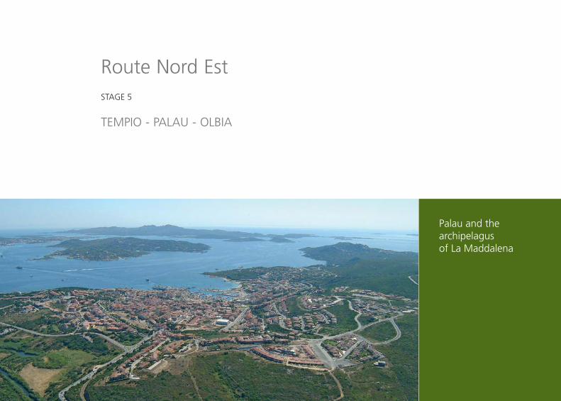
Palau and thearchipelagus of La Maddalena
Route Nord EstSTAGE 5
TEMPIO - PALAU - OLBIA

76
Stage 5Tempio - Palau - OlbiaTot. stage Km 120,8 - Ascent stage m 1624 - Tot. route Km 454,3Level of difficulty: hard
HighlightsCapo d’Orso and La Maddalena archipelagus The Costa Smeralda
Location km Total Kms Ascent Direction
Tempio - Olbia Calangianus exit 0 0 0 � Set off towards, descent road
Nuchis crossing 2 2 0 � Turn left towards Nuchis, cross it and go on towards Calangianus
SS 127 crossroads 3,9 5,9 72 � Turn left towards Calangianus
La Maciona roundabout 16 21,9 273 � Go on towards Sant'Antonio di Gallura, cross it and go on towards Arzachena
Arzachena 22 43,9 625 � Turn left at the crossroad Palau - Cannigione
Arzachena 0,7 44,6 630 � ! Turn right in via Chiodino Raimondo before the gardens
Palau Salt pits crossroads 2,2 46,8 692 � Turn left towards Palau Saline
Cannigione crossroads 8,5 55,3 898 � Turn right towards Cannigione. For Palau half-stage go straight on
crossroads after the salt pits 0,9 56,2 858 � After 200 m of dirt road turn left towards Cannigione
Baia Sardinia crossroads 10,4 66,6 923 � Turn left towards Baia Sardinia
Porto Cervo crossroads 1,9 68,5 936 � Turn left towards Porto Cervo
Baia Sardinia crossroads 6,6 75,1 998 � Turn right towards Porto Cervo
Porto Cervo crossroads 3,8 78,9 1078 � Turn right towards Porto Cervo
Olbia roundabout 5,9 84,8 1210 � Turn left towards Olbia
Romazzino crossroads 1,5 86,3 1225 � Turn right towards Olbia - Golfo Aranci
Portisco crossroads 8,1 94,4 1369 � Turn left towards Olbia - Golfo Aranci
Golfo Aranci crossroads 5,8 100,2 1382 � Turn left towards Olbia - Golfo Aranci
Golfo Aranci crossroads 4,2 104,4 1469 � Turn left towards Golfo Aranci
Olbia crossroads 4,6 109 1518 � Turn right towards Olbia
Pittulongu crossroads 5,3 114,3 1572 � Turn right towards Pittulongu - Bados
Olbia entrance 6,5 120,8 1624 � End of the stage. ! Traffic up to Olbia's city centre


Lake Gusana near Gavoi
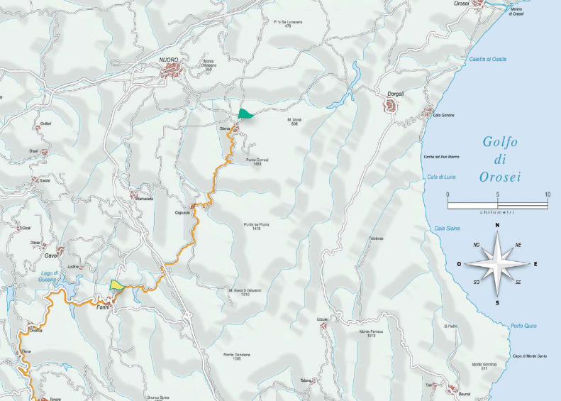
Route EstSTAGE 1
OLIENA - FONNI - ARITZO

Stage 1Oliena - Fonni - AritzoTot. stage Km 81,5 - Ascent stage m 2780 - Tot. route Km 81,5Level of difficulty: hard
HighlightsThe Supramonte and Gennargentu mountains rangeThe Murals of Orgosolo
Location km Total Kms Ascent Direction
Oliena - Orgosolo exit 0 0 0 � Easier climb option along main road
Orgosolo 15,7 15,7 900 � Cross the village and leave towards Pratobello
Pratobello crossing 7,54 23,24 1380 � Turn right towards Pratobello - Fonni - Lanusei
1° Pratobello crossing 4,56 27,8 1400 � Turn left towards Lago Govossai after passing the underpass
2° Pratobello crossing 0,9 28,7 1400 � Turn right towards Lago Govossai - Fonni
Fonni crossroads 7,5 36,2 1650 � Turn left towards Fonni
Fonni 1,8 38 1700 � Cross the village towards Lago di Gusana - Ovodda
Lago di Gusana crossroads 5,5 43,5 1700 � Turn right towards Ovodda
Ovodda 9,7 53,2 1850 � Cross the village towards Tiana
Tiana 4,9 58,1 1850 � Go straight on towards Tonara
Tonara crossing 8,2 66,3 1960 � Turn left towards Tonara
Tonara 2,2 68,5 2050 � Go on towards Aritzo
Belvì 11,4 79,9 2650 � Go on towards Aritzo
Aritzo 1,6 81,5 2780 � End of the stage
80

The Texile peak, Aritzo
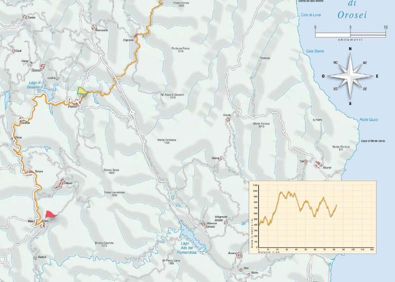
Route EstSTAGE 2
ARITZO - LACONI - NURRI
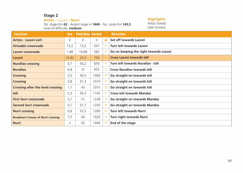
84
Stage 2Aritzo - Laconi - NurriTot. stage Km 62 - Ascent stage m 1440 - Tot. route Km 143,5Level of difficulty: medium
HighlightsAritzo forestsLake Gusana
Location km Total Kms Ascent Direction
Aritzo - Laconi exit 0 0 0 � Set off towards Laconi
Ortuabis crossroads 13,2 13,2 547 � Turn left towards Laconi
Laconi crossroads 1,48 14,68 585 � Go on keeping the right towards Laconi
Laconi 10,82 25,5 790 � Cross Laconi towards Isili
Nurallao crossing 4,7 30,2 878 � Turn left towards Nurallao - Isili
Nurallao 6,8 37 925 � Cross Nurallao towards Isili
Crossing 3,5 40,5 1000 � Go straight on towards Isili
Crossing 0,8 41,3 1010 � Go straight on towards Isili
Crossing after the level crossing 1,7 43 1075 � Go straight on towards Isili
Isili 2,3 45,3 1145 � Cross Isili towards Mandas
First Serri crossroads 5,7 51 1238 � Go straight on towards Mandas
Second Serri crossroads 0,7 51,7 1250 � Go straight on towards Mandas
Nurri crossing 0,8 52,5 1280 � Turn left towards Nurri
Roadman's house of Nurri crossing 7,5 60 1420 � Turn right towards Nurri
Nurri 2 62 1440 � End of the stage


Selene forest, Lanusei
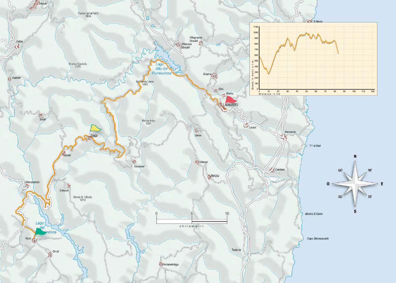
Route EstSTAGE 3
NURRI - SEUI - LANUSEI

88
Stage 3Nurri - Seui - LanuseiTot. stage Km 83,6 - Ascent stage m 1453 - Tot. route Km 227,1Level of difficulty: demanding
HighlightsNuraghe ArdasaiThe Perda Liana peak
Location km Total Kms Ascent Direction
Nurri crossing 0 0 0 � Set off from the crossroads with the SS 198 towards Seui – Villanovatulo
Villanovatulo crossing 6,8 6,8 23 � Go straight on towards Seui
Bridge 2,6 9,4 24 � Cross the bridge over Lago Flumendosa
Esterzili crossing 11,2 20,6 450 � Go straight on
Sadali entrance 4,1 24,7 541 � Go straight on towards Lanusei Seui
Aritzo - Seulo crossroads 1,1 25,8 560 � Go straight on
Seui entrance 6,7 32,5 716 � Go straight on crossing the village (water source)
Perda Liana crossroads 6,3 38,8 819 � ! Turn left and go up towards San Cristoforo - Perda Liana - Montarbu
Crossroads per foresta Montarbu 3,1 41,9 975 � Go on keeping the left towards Foresta di Montarbu
Montarbu barracks crossroads 1,9 43,8 1009 � Go straight on towards Perda Liana
Crossroads 5,7 49,5 1093 � Go straight on
Nuraghe Ardasai 0,84 50,34 1098 � Go straight on
Perda Liana crossroads 11,96 62,3 1284 � Go straight on (detour on the right to Perda Liana peak)
Crossroads 11,7 74 1380 � Turn left towards Lanusei
Crossroads with the SS 389 1,3 75,3 1400 � Turn right towards Lanusei on the SS 389
Crossroads towards Arzana 4,5 79,8 1453 � Go straight on towards Lanusei
Crossroads towards Lanusei 0,6 80,4 1453 � Take the SS 390 and go on towards Lanusei
Lanusei 3,2 83,6 1453 � End of the stage


Baunei valley
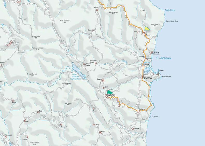
Route EstSTAGE 4
LANUSEI - BAUNEI - DORGALI

92
Stage 4Lanusei - Baunei - DorgaliTot. stage Km 96,3 - Ascent stage m 1283 - Tot. route Km 323,4Level of difficulty: demanding
HighlightsLandscape along the ss 125 roadThe coves of the Orosei gulf
Location km Total Kms Ascent Direction
Lanusei roundabout - Loceri exit 0 0 0 � Set off towards Loceri
Loceri 7,26 7,26 0 � Cross the village towards Barisardo
Barisardo 7,04 14,3 8 � Go on towards Marina di Barì - Torre di Barì
Cea crossroads 3,15 17,45 17 � ! Turn left towards Cea and turn left again after 100 m
Crossroads 2,65 20,1 76 � ! Turn left after the green metal post
Lido di Cea crossroads 0,75 20,85 77 � Go on keeping the left
Crossroads 2,15 23 100 � Turn right
Roundbout before Tortolì 7 30 154 � Turn right towards Tortolì and go on towards Olbia - Nuoro
Girasole crossroads 3 33 170 � Go straight on towards Olbia - Nuoro
Crossroads with ss (national road) 2 35 171 � Turn right towards Lotzorai - Olbia - Orosei
Lotzorai 0,5 35,5 175 � Cross the village towards Baunei - Olbia
Santa Maria Navarrese crossroads 1,2 36,7 184 � Go straight on
Baunei 8,5 45,2 607 � Cross the village and go straight on
Genna Silana pass 31,8 77 1270 � Go straight on
Tunnels towards Calagonone 18,3 95,3 1282 � Go straight on towards Dorgali (possible detour towards Calagonone)
Dorgali 1 96,3 1283 � Turn left and enter Dorgali. End of the stage


Mont’albo, Lula
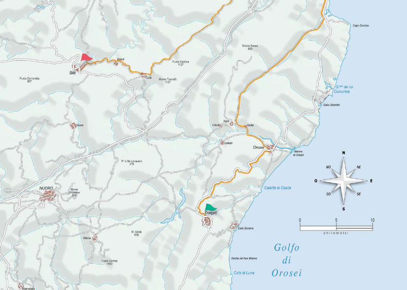
Route EstSTAGE 5
DORGALI - SINISCOLA - BITTI

96
Stage 5Dorgali - Siniscola - BittiTot. stage Km 108,2 - Ascent stage m 1282 - Tot. route Km 431,6Level of difficulty: demanding
HighlightsBidderosa park in OroseiMont’Albo range
Location km Total Kms Ascent Direction
Dorgali - Orosei exit 0 0 0 � Set off towards Orosei - Siniscola
Orosei crossroads 1,65 1,65 0 � Go straight on towards Orosei. (water source)
Orosei 16,75 18,4 55 � Cross the village towards Nuoro
Orosei exit towards Nuoro 1,4 19,8 70 � Turn left and go on towards Nuoro
Onifai - Olbia crossroads 3,5 23,3 75 � Turn right towards Onifai and pass the bridge
Onifai 0,7 24 75 � Cross the village towards Irgoli
Irgoli 1,7 25,7 75 � After the bridge turn right towards Siniscola - Capo Comino
Crossroads with the SS 125 20,8 46,5 267 � Turn left on the SS 125 towards Olbia - Siniscola
Siniscola 11,6 58,1 340 � Cross the village towards Lodè
Siniscola exit 2,5 60,6 405 � Exit the village towards Lodè - Monte Albo
Sant'Anna crossroads 8,5 69,1 922 � Turn left towards Monte Albo - Lula. (water fountain after 15 km)
Lula 25,9 95 1150 � Cross the village towards Onanì Bitti
Lula exit 1,5 96,5 1155 � Go straight on towards Onanì
Onanì 3,8 100,3 1197 � Cross the village and go on towards Bitti
Crossroads before Bitti 7,5 107,8 1282 � Go straight on towards Bitti
Bitti 0,4 108,2 1282 � End of the stage

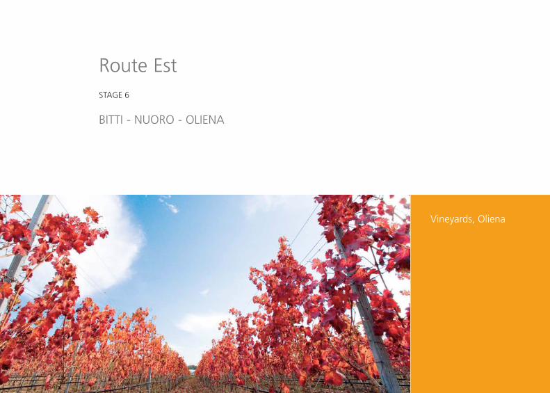
Vineyards, Oliena
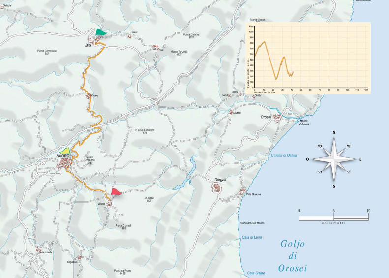
Route EstSTAGE 6
BITTI - NUORO - OLIENA

100
Stage 6Bitti - Nuoro - OlienaTot. stage Km 45 - Ascent stage m 745 - Tot. route Km 476,6Level of difficulty: easy
HighlightsSu Tempiesu sacred well in OruneSu Gologone spring in Oliena
Location km Total Kms Ascent Direction
Bitti - Nuoro exit 0 0 0 � Set off towards Nuoro on the SS 389
Crossroads 7,9 7,9 224 � Follow the main road
Crossroads towards Orune 2,7 10,6 255 � Turn left towards Orune
Crossroads towards Nuoro 11,9 22,5 255 � Go straight on
Crossroads towards Nuoro 0,9 23,4 256 � Turn right towards Nuoro La Solitudine
Nuoro la solitudine 9,5 32,9 645 � Cross Nuoro and leave towards Oliena
Orgosolo - Oliena crossroads 3,6 36,5 660 � Having left Nuoro after about 1,5 km turn left towards Oliena
Oliena 8,5 45 745 � Enter Oliena. End of the stage

103
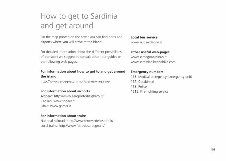
How to get to Sardiniaand get aroundOn the map printed on the cover you can find ports andairports where you will arrive at the island.
For detailed information about the different possibilitiesof transport we suggest to consult other tour guides orthe following web pages.
For information about how to get to and get aroundthe islandhttp://www.sardegnaturismo.it/servizi/viaggiare/
For information about airportsAlghero: http://www.aeroportodialghero.it/Cagliari: www.sogaer.itOlbia: www.geasar.it
For information about trainsNational railroad: http://www.ferroviedellostato.it/Local trains: http://www.ferroviesardegna.it/
Local bus servicewww.arst.sardegna.it
Other useful web-pageswww.sardegnaturismo.itwww.sardiniahikeandbike.com
Emergency numbers118: Medical emergency (emergency unit) 112: Carabinieri113: Police1515: Fire-fighting service
Cyclotourism guide of Sardinia
Cyclotourism guide of Sardinia © 2008 Autonoumous Region of SardiniaCOUNCELLORSHIP FOR TOURISM, HANDCRAFTS AND COMMERCE, Viale Trieste 105, 09123 - Cagliari
Edited by Sardegna Ricerche within the interregional project “Cicloturismo” law 135/2001, art. 5, par.5.
General coordination: Cesare MouProject: Simone ScalasAssistant to the route design: Marcello UsalaCarthography: Corrado Conca – © Edizioni segnaviaLayout: Alfredo Scrivani Image Editing: Manrico AdamoTexts: Cesare Mou, Simone ScalasPhoto database: Egidio Trainito, Manrico Adamo, Enrico Spanu.
Print and layout: Arti Grafiche Pisano srl - CagliariTexts composed in Frutiger (Adrian Frutiger, 1928)
Print ended on June 2008
The counsellorship for tourism, handcrafts and commerce publishes this book for divulgation. All responsibility is refused for possible print mistakes or unintentional omissions.

Airport
Port
Trains
Regional railways
Bus

www.sardegnaturismo.it
Top Related