


Languages
Pages
Legal


C h a p t e r 6
Recommendations

This page was left blank intentionally.

reco
mm
end
ati
ons
Introduction
This chapter serves as the summary of recommendations for the Connections 2040 RMP that is organized by county to allow plan participants to easily locate details important to them. This approach offers Gadsden, Jefferson, Leon, and Wakulla counties (and the communities contained therein) a subset of the RMP where their county specific strategy (vision and needs) is expressed. This chapter also provides a quick reference inventory of projects that advanced into the cost-feasible portion of the Connections 2040 RMP. Supporting this list is a set of project sheets that offers the reader more information about cost-feasible projects including a description, vicinity map, and initial need and purpose statement.
“This chapter serves as a summary of recommendations for the Connections 2040 RMP organized by county in order to allow plan participants to easily locate details important to them.”

| 2 0 4 0 R E G I O N A L M O B I L I T Y P L A N 6. 1
Recommendations The Connections 2040 RMP is supported by three foundational elements: an Opportunities Plan, a Needs Plan, and a Cost Feasible Plan. The Opportunities Plan supports the visioning process; the Needs Plan development provides analysis; and the Cost Feasible Plan provides a framework for project selection. Collectively, each plays a critical role in the RMP by fulfilling aspects of a rational planning process. Ultimately, this process informs the creation of recommendations intended to respond to the changing needs of the region.
The process diagram below reinforces the relationship between each of these plan elements as well as the supporting activities that inform their creation. The following narrative describes each of these plan elements as well as the process that led to their development.
The Opportunities Plan
The Opportunities Plan for the Connections 2040 RMP is a set of unconstrained vision projects for the Capital Region.
The list of projects is intentionally unconstrained when considering cost and feasibility. This allows each county to assemble a set of projects that aligns with emerging trends, desired vision and community aspirations. In an effort to capture ideas for the Opportunities Plan, detailed work sessions were conducted in each county. These work sessions included local staff, elected officials, and representatives from CRTPA. During these meetings existing transportation priorities were discussed, and projects intended to respond to emerging community needs were reviewed. In addition, an inventory of candidate transportation projects resulting from a screening of past, current, and ongoing plans and studies was created. The results of public workshops held in each county provided another opportunity to highlight county specific needs. Finally, a review of comments from the MetroQuest online survey allowed for a broader set of participants to weigh in on transportation ideas believed to be important to the region’s future. Because the Opportunities Plan is unconstrained it contains the greatest quantity of projects (when compared to the Needs Plan and Cost Feasible Plan). These projects served as a pool of potential projects that could respond to identified needs.

RECOMMENDATIONS | 6. 2
The Needs Plan
The Needs Plan identifies projects that satisfy an existing or projected future deficiency within the 2040 planning horizon. This process involves two basic steps:
a) Identifying existing and forecasted future deficiencies; and
b) Identifying projects that respond to identified needs.
Deficiencies were identified through qualitative and quantitative means. Committee and public input was documented through regular meetings as well as through online opportunities such as the MetroQuest survey. In addition, travel modeling revealed performance deficiencies related to delay and capacity which highlighted existing and future transportation challenges.
The next step involved the identification of projects intended to respond to the documented deficiencies. This was largely accomplished by selecting projects from the Opportunities Plan. The resulting Needs Plan incorporated input from CRTPA staff, committees, stakeholders, and the public. This information was combined with elements of the Congestion Management Plan, 2035 RMP, StarMetro TDP, and the Existing Conditions Report to fully consider the best method to address identified needs. The process itself considers regional and statewide planning initiatives alongside the plan’s goals and objectives (see Chapter 1).
The Needs Plan responds to specific deficiencies and therefore can be considered a narrow subset of the Opportunities Plan. Bicycle and pedestrian projects were divided into regionally significant and non-regionally significant recommendations prior to their consideration for the Needs Plan. Lower cost bicycle and pedestrian projects can be considered for funding through the state Transportation Alternatives Program. As such, there is not a need to prioritize these projects at the regional level. These projects have been identified in the Opportunities Plan, but as a result of this approach do not progress to the Needs Plan.
The Needs Plan focuses on the capital needs of the system. As a result, Roadway maintenance and preservation projects identified in the Opportunities Plan did not progress into the Needs Plan.
The Cost Feasible Plan The Cost Feasible Plan represents the project selection process for multimodal improvements in the CRTPA area. These projects have been vetted through project evaluation and prioritization, as detailed in Chapter 4. Each project considers planning level cost estimates based on constructability, environmental and social characteristics/mitigation, and proposed improvement type. The committed projects identified in the Transportation Improvement Plan (TIP) were included to ensure the projects consider current activities. Because the Cost Feasible plan is financially constrained, it represents the narrowest subset of projects from the Needs Plan that is reasonably expected to be funded within the 2040 planning horizon.
The Cost Feasible Plan projects are organized into tiers:
Tier 1 - Existing Plus Committed Projects (2016-2020) Tier 2 - Short Range Projects (2021-2025) Tier 3 - Interim Year Projects (2026-2030) Tier 4 – Plan Horizon Projects (2031-2040) Beyond 2040 – Vision Projects
More detail on the Cost Feasible Plan development is included in Chapter 5.

| 2 0 4 0 R E G I O N A L M O B I L I T Y P L A N 6. 3
Chapter Organization
This chapter is organized by county to increase the user friendliness of the report for CRTPA member jurisdictions. The result is a set of county-specific sections that summarize the Opportunities Plan, Needs Plan, and projects that have been included in the Cost-Feasible Plan. (See Chapter 3 for the development of the Opportunities and Needs Plans.) The excerpts contained in this chapter are solely intended to serve as county-specific reference material. Within each section, individual project sheets catalogue cost-feasible project for Tiers 1, 2, and 3. Each project sheet offers information about cost-feasible projects such as the project ID, description, location, length, cost, vicinity, initial need and purpose. Tier 4 projects are summarized in a table.
When viewed as a whole, these sections represent the transportation strategy for each county. When viewed in aggregate, they represent the mobility strategy for the region.

RECOMMENDATIONS | 6. 4
Gadsden County
Opportunities Plan
Refer to Chapter 3 for more information on the development of the Opportunities Plan.
394 corridor and spot projects Various multimodal improvements Focus on pedestrian enhancements
Corridor Recommendations No. of Projects
Roadway 162 Bicycle/ Pedestrian 217
Transit 2 Total 381
Spot Recommendations No. of Projects
Roadway 5 Transit 4 Freight 1
Beautification 3
Total 13

| 2 0 4 0 R E G I O N A L M O B I L I T Y P L A N 6. 5
Gadsden County Needs Plan Roadway
21 projects Strategies include new roads, road widenings, and general improvements
New Road
Project Name Total Cost
Quincy Bypass (South) $ 30,811,532 Quincy Bypass (North) $ 9,285,232 Quincy Bypass $ 15,491,642 City of Midway Access Road $ 17,209,166 Main St Bypass - Havana $ 11,475,605 Washington St Bypass - Chattahoochee $ 7,262,370 Washington St Bypass $ 13,496,346 Total $105,031,893
Narrow Road
Project Name Total Cost
Main St - Downtown Havana $ 4,111,456
Total $ 4,111,456
Improvement
Project Name Total Cost
Hardaway Hwy $ 42,191,719
Bettstown Rd $ 14,444,165
McPhaul Rd Reconstruction $ 3,309,944
Total $59,945,828
Widen Road
Project Name Total Cost
Attapulgus Hwy $ 93,634,744
Salem Rd $ 57,626,111
MLK Jr Blvd $ 14,495,054
Bonnie Hill Rd $ 25,449,041
Flat Creek Rd $ 9,141,044
Telogia Creek Rd $ 15,258,398
Hosford Hwy $ 64,212,073
Tolar White Rd $ 21,384,234
Concord Rd $ 48,080,070
Bonnie Hill Rd $ 80,645,173
Total $429,925,942
RECOMMENDATIONS | 6. 6
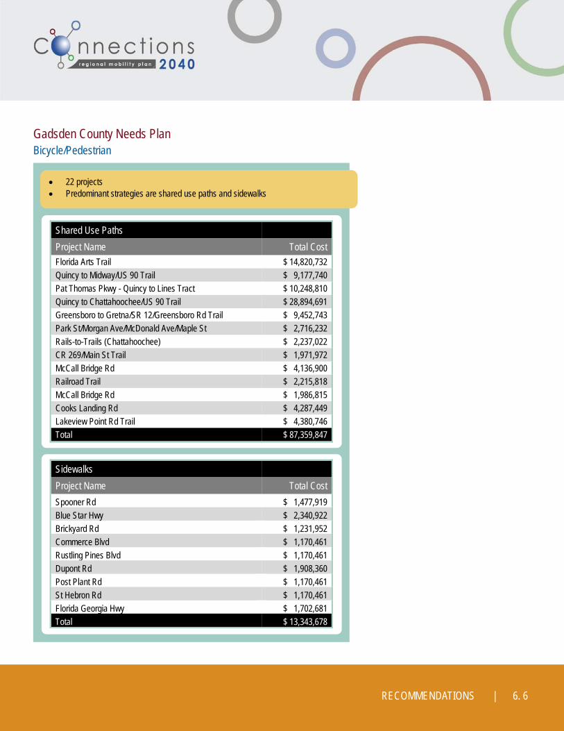
Gadsden County Needs Plan Bicycle/Pedestrian
22 projects Predominant strategies are shared use paths and sidewalks
Shared Use Paths
Project Name Total Cost
Florida Arts Trail $ 14,820,732 Quincy to Midway/US 90 Trail $ 9,177,740 Pat Thomas Pkwy - Quincy to Lines Tract $ 10,248,810 Quincy to Chattahoochee/US 90 Trail $ 28,894,691 Greensboro to Gretna/SR 12/Greensboro Rd Trail $ 9,452,743 Park St/Morgan Ave/McDonald Ave/Maple St $ 2,716,232 Rails-to-Trails (Chattahoochee) $ 2,237,022 CR 269/Main St Trail $ 1,971,972 McCall Bridge Rd $ 4,136,900 Railroad Trail $ 2,215,818 McCall Bridge Rd $ 1,986,815 Cooks Landing Rd $ 4,287,449 Lakeview Point Rd Trail $ 4,380,746 Total $ 87,359,847
Sidewalks
Project Name Total Cost
Spooner Rd $ 1,477,919 Blue Star Hwy $ 2,340,922 Brickyard Rd $ 1,231,952 Commerce Blvd $ 1,170,461 Rustling Pines Blvd $ 1,170,461 Dupont Rd $ 1,908,360 Post Plant Rd $ 1,170,461 St Hebron Rd $ 1,170,461 Florida Georgia Hwy $ 1,702,681 Total $ 13,343,678

| 2 0 4 0 R E G I O N A L M O B I L I T Y P L A N 6. 7
Gadsden County Cost Feasible Plan
ID Project Name Strategy Tier 1 Tier 2 Tier 3 Tier 4 Total Cost
156 Florida Arts Trail Shared Use Path CRTPA CRTPA $16,649,186
160 Quincy to Midway/US 90 Trail Shared Use Path CRTPA CRTPA CRTPA $9,649,057
161 Quincy to Chattahoochee / US 90 Trail
Shared Use Path CRTPA $24,820,899
162 Pat Thomas Pkwy - Quincy to Lines Tract
Shared Use Path CRTPA $13,054,332
333 Main St - Downtown Havana Narrow Road CRTPA $3,531,792
Total $67,705,266

RECOMMENDATIONS | 6. 8

| 2 0 4 0 R E G I O N A L M O B I L I T Y P L A N 6. 9

RECOMMENDATIONS | 6. 10

| 2 0 4 0 R E G I O N A L M O B I L I T Y P L A N 6. 11

RECOMMENDATIONS | 6. 12

| 2 0 4 0 R E G I O N A L M O B I L I T Y P L A N 6. 13
Jefferson County
Opportunities Plan
Refer to Chapter 3 for more information.
174 corridor and spot projects Corridor recommendations relatively split Most spot recommendations are roadway
Corridor Recommendations No. of Projects
Roadway 72 Bicycle/ Pedestrian 84
Transit 0 Total 156
Spot Recommendations No. of Projects
Roadway 10 Bicycle/Pedestrian 1
Freight 3 Other 4
Total 18
RECOMMENDATIONS | 6. 14
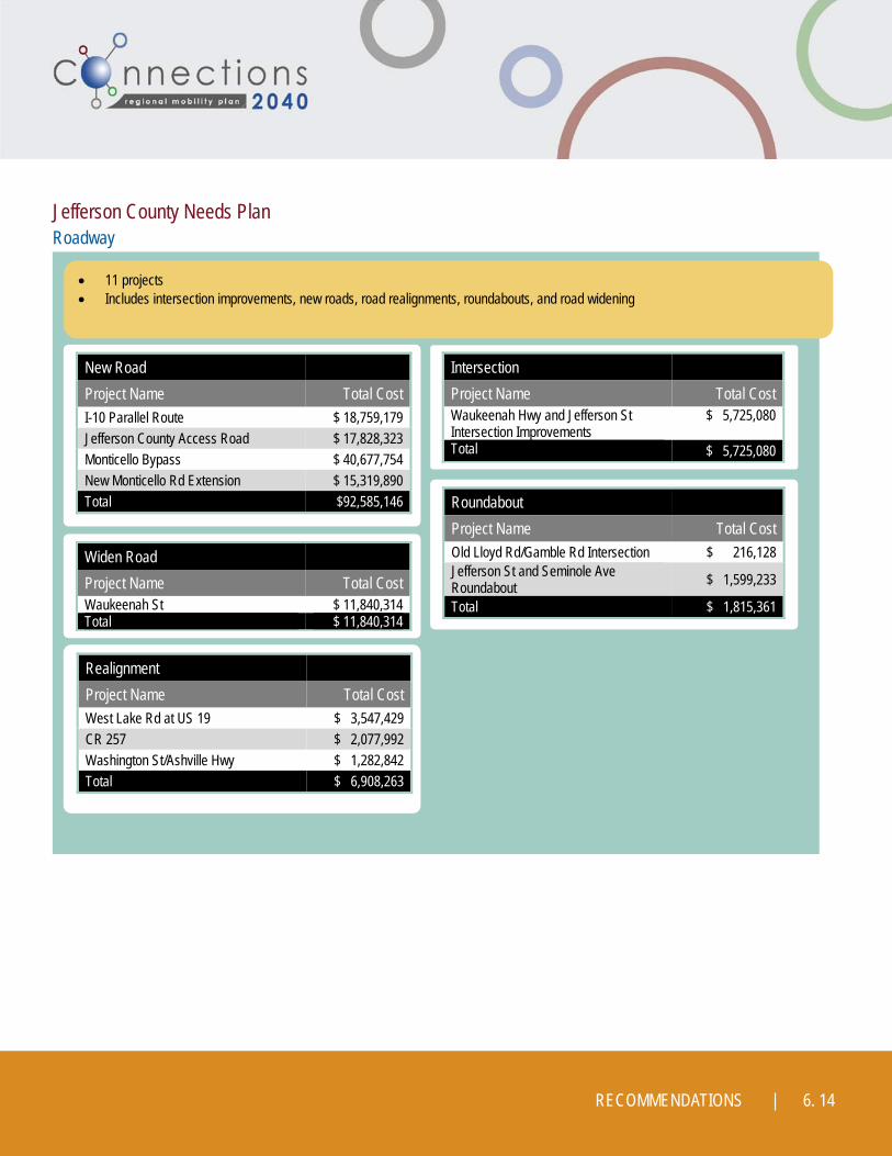
Jefferson County Needs Plan Roadway
11 projects Includes intersection improvements, new roads, road realignments, roundabouts, and road widening
New Road
Project Name Total Cost
I-10 Parallel Route $ 18,759,179 Jefferson County Access Road $ 17,828,323 Monticello Bypass $ 40,677,754 New Monticello Rd Extension $ 15,319,890 Total $92,585,146
Intersection
Project Name Total Cost Waukeenah Hwy and Jefferson St Intersection Improvements
$ 5,725,080
Total $ 5,725,080
Roundabout
Project Name Total Cost
Old Lloyd Rd/Gamble Rd Intersection $ 216,128 Jefferson St and Seminole Ave Roundabout $ 1,599,233
Total $ 1,815,361
Realignment
Project Name Total Cost
West Lake Rd at US 19 $ 3,547,429
CR 257 $ 2,077,992
Washington St/Ashville Hwy $ 1,282,842
Total $ 6,908,263
Widen Road
Project Name Total Cost Waukeenah St $ 11,840,314 Total $ 11,840,314

| 2 0 4 0 R E G I O N A L M O B I L I T Y P L A N 6. 15
Jefferson County Needs Plan Bicycle/Pedestrian
11 projects Each project is a shared use path
Shared Use Paths
Project Name Total Cost Project Name Total Cost
Jefferson St Trail $ 13,313,992 Progress Energy Rail Trail III $ 1,263,758
Progress Energy Rail Trail IV $ 10,294,542 US 98 Trail $ 10,205,485
Washington St Trail $ 12,726,641 Capps Hwy Trail $ 12,283,477
Progress Energy Rail Trail II $ 5,301,000 Monticello Bike Trail Extension $ 2,157,538
Progress Energy Rail Trail V $ 2,131,002 Martin Rd Trail $ 276,300
Progress Energy Rail Trail I $ 15,288,084
Total $522,391,521

RECOMMENDATIONS | 6. 16
Jefferson County Cost Feasible Plan
ID Project Name Strategy Tier 1 Tier 2 Tier 3 Tier 4 Total Cost
567 Monticello Bike Trail Extension Shared Use Path CRTPA CRTPA $ 2,157,538
1254 Martin Rd Trail Shared Use Path CRTPA $ 276,300
4 Old Lloyd Rd/Gamble Rd Intersection
Roundabout CRTPA $ 216,128
6 Jefferson St and Seminole Ave Roundabout Roundabout CRTPA $ 1,599,233
Total $ 4,249,199

| 2 0 4 0 R E G I O N A L M O B I L I T Y P L A N 6. 17

RECOMMENDATIONS | 6. 18

| 2 0 4 0 R E G I O N A L M O B I L I T Y P L A N 6. 19

RECOMMENDATIONS | 6. 20

| 2 0 4 0 R E G I O N A L M O B I L I T Y P L A N 6. 21
Leon County
Opportunities Plan
Refer to Chapter 3 for more information.
1,033 corridor and spot projects Wide variety of multimodal improvements including
corridor and spot specific locations
Corridor Recommendations No. of Projects
Roadway 87 Bicycle/ Pedestrian 799
Transit 14 Other 11 Total 911
Spot Recommendations No. of Projects
Roadway 54 Bicycle/Pedestrian 68
Total 122
Top Related