


Languages
Pages
Legal


1
6th December 2012 ASX ANNOUNCEMENT / MEDIA RELEASE
CAMPOONA GRAPHITE MAIDEN JORC RESOURCE
HIGHLIGHTS
• Maiden JORC Resource at Campoona of 2.572Mt grading 12.3% TGC with 310,800 tonnes of contained graphite at a lower cut‐off grade of 5%TGC.
• Scoping Study activities underway including environmental baseline studies.
• Significant progress on defining the optimum processing flow sheet for the extraction of
high value graphite product has been achieved. Results to date demonstrate >98%TGC concentrates are reproducible with excellent recoveries.
• Phase 2 Resource drilling at Central Campoona is scheduled to start February 2013. • 80% of the Campoona strike is undrilled. Resource Extension drilling north and south of
Campoona Shaft and Central Campoona is planned to commence in April 2013 to define likely Exploration Target for the combined Campoona graphite deposit.
• Regional drilling targeting multiple EM conductors near Campoona is planned for April
2013.
Archer Exploration Limited (ASX: AXE; “Archer”) is pleased to report a Phase 1 JORC Resource for the Campoona graphite deposit as currently drilled. The Campoona Graphite Project is located 15km north of Cleve on Eyre Peninsula, South Australia.
The Phase 1 Campoona JORC Resource which has been achieved within 9 months of the discovery drill hole is estimated to contain almost 400,000 tonnes of contained graphite that occurs as highly graphitic, uniform and steeply dipping schist which outcrops in the Campoona Shaft area. Less than 20% of the Campoona shear has been drill tested.
Campoona JORC Resource
The MiningPlus resource summary for the Project is provided in Appendix 1, including details on the resource calculation used.
The Campoona JORC Resource estimation was conducted by MiningPlus, an independent expert resource consultancy with offices in Australia, Canada and South America. Information used in the Resource estimates included five (5) diamond drill holes and thirty seven (37) Reverse Circulation (RC) drill holes completed up to the end of September this year (see Figure 1 below).

2
The JORC Resource for Campoona is shown in Tables 1 and 2 below.
Table 1. Campoona JORC Resource (2%TGC lower cut‐off grade)
Area Resource Category
Tonnes (Mt)
Graphite (% TGC)
Contained Graphite(tonnes)
Campoona Shaft Measured 0.339 14.8 50,200
Indicated 1.059 12.7 134,500
Inferred 3.475 5.0 173,800
Central Campoona*
Inferred 0.397 10.1 40,100
Combined Total Resource 5.270 7.6 397,600
Table 2. Campoona JORC Resource (5%TGC lower cut‐off grade)
Area Resource Category
Tonnes (Mt)
Graphite (% TGC)
Contained Graphite(tonnes)
Campoona Shaft Measured 0.339 14.8 50,200
Indicated 1.056 12.7 134,100
Inferred 0.837 10.7 89,600
Central Campoona*
Inferred 0.295 12.5 36,900
Combined Total Resource 2.527 12.3 310,800
**Central Campoona Resource estimation confined to 200m of known strike of 1,400m
The Central Campoona graphite pod, located just 2km south of Campoona Shaft, has been drilled on a 200m spacing with on‐section drill spacings from 20‐40m. Central Campoona has a known strike of 1,400m. Drill density over a length of 200m of the known strike was deemed sufficient to support an Inferred Resource of 0.295Mt grading 12.5%TGC.
Archer’s Managing Director, Mr Gerard Anderson, said: “The completion of our Maiden JORC Resource is a landmark event for Archer and provides a strong foundation for what we believe will quickly progress into a quality, long‐life mining operation.”
“Archer has progressed from a virgin discovery to a substantial high‐grade Maiden JORC Resource in less than 9 months – an outstanding achievement by our team,” Mr Anderson continued, “The Phase I Resource encompasses only the data from Campoona Shaft and a small

3
portion of Central Campoona. In‐fill drilling at Central Campoona is planned to commence in February 2013 with results to be incorporated into the Phase II Resource likely late in the second Quarter of next year.”
“The standout features of Campoona are the high grades and the depth of weathering of the mineralisation. This combined with the continuous and thick nature of the graphitic schist and the host shear zone makes this a unique and important deposit.”
“This Maiden JORC resource cements Campoona’s position as one of the most significant new graphite discoveries in Australia. With less than 20% of the host shear drilled to date, the reasonable expectation supported by airborne EM results, is that further exploration is likely to lead to much more graphite being discovered. The deposit’s proximity to infrastructure represents a fantastic asset for Archer shareholders that we are confident will continue to grow.”
“Over the last two months we have made significant progress on defining the optimum processing flow sheet for the extraction of high value graphite products. The intense weathering of the deposit has presented both challenges and opportunities. I am delighted to report that the issues have been successfully eliminated through the application of excellent mineral science led by Dr David Lock. The rigorous and systematic testing has delivered invaluable knowledge. We now know how to treat our ores to achieve ultra‐pure concentrates. Results to date show us that >98%TGC concentrates are reproducible with excellent recoveries. No acid was needed or used to achieve this result. Further grade enhancements are realistically expected. Testing will now use that knowledge to quantify the product types across the length, breadth and depth of the deposit with results being progressively announced over the next two months.”
“We have now turned our focus on defining development options for Campoona. We have already completed the Environmental Fauna and Flora Baseline Studies to provide important Spring season data needed to support a future Mine Lease Proposal. Over the next quarter we will commence Scoping Studies which we expect to lead directly into a Pre‐Feasibility and Definitive Feasibility Study commencing in mid‐2013”.
SCOPING STUDY
Following completion of the Maiden JORC resource estimate, Archer has initiated key activities as part of a Scoping Study to assess potential mine development options for the Campoona Project and commenced the project approvals process. This includes:
• Commencement of the process for obtaining key environmental approvals including the appointment of environmental consultants to conduct baseline flora and fauna surveys and project permitting.
• Metallurgical characterisation well advanced with the process flow sheet and equipment selection set for completion during the first quarter of 2013.
• Planning for bulk sampling and pilot‐scale testing well advanced. • Assessment of electricity supply options for the Campoona Project. • Assessment of water supply options for the Campoona Project.
The current Scoping Study is expected to transition into a Pre‐Feasibility Study commencing in mid‐calendar year 2013, which in turn will lead directly to a Definitive Feasibility Study commencing in the second half of 2013. This will provide a strong foundation for a potential

4
mine development process commencing in 2014.
PHASE 2 CAMPOONA RESOURCE DRILLING
Phase 2 Resource drilling set to commence February 2013 will close the drill coverage to 100m x 20m spacings to enable estimation of Resources for the entire strike length of that deposit.
Graphite at Campoona Shaft and Central Campoona comprise the same highly graphitic schist made podiform through a combination of cross faulting and boudinaging. Airborne EM indicates strong extensional conductors to the north and south opening up the likelihood of defining the same graphite horizon over a further 8 kilometres of strike along with fold repetitions to the south‐east (Figure 1). Drill testing of these highly conductive bodies will immediately follow the Phase 2 Resource drilling at Central Campoona.
Figure 1. Schematic geology of Campoona Graphite Deposit

5
All drilling results will be incorporated into the Phase II Campoona Resource estimate expected for release late in the second Quarter of 2013.
In addition to drilling the Campoona structure, Archer will drill a number of regional graphite targets commencing in the second Quarter of 2013.
REGIONAL EXPLORATION
Archer will soon commence regional drill testing to progressively test a series of known graphite occurrences and a number of additional EM targets identified by the regional airborne EM surveys over Archer’s 1,200km2 landholding at Cleve (see Figure 1 below). The objective of Archer’s regional program is to identify those graphite targets likely to translate into future resources for any Campoona‐based processing facility.
For further information please contact: Mr Greg English Chairman Archer Exploration Limited Tel: (08) 8272 3288
Mr Gerard Anderson Managing Director Archer Exploration Limited Tel: (08) 8272 3288
The exploration results reported herein, insofar as they relate to mineralisation, are based on information compiled by Mr. Wade Bollenhagen, Exploration Manager of Archer Exploration Limited. Mr. Bollenhagen is a Member of the Australasian Institute of Mining and Metallurgy who has more than eighteen years experience in the field of activity being reported. Mr Bollenhagen has sufficient experience which is relevant to the style of mineralisation and type of deposit under consideration and to the activity that he is undertaking to qualify as a Competent Person as defined in the 2004 Edition of the “Australasian Code for Reporting of Exploration Results, Mineral Resources and Ore Reserves” relating to the reporting of Exploration Results. Mr. Bollenhagen consents to the inclusion in the report of matters based on his information in the form and context in which it appears

1
Memorandum
To: Wade Bollenhagen
Cc:
From: Bruce Godsmark
Date: 5-12-2012
Subject: Campoona Shaft Resource Estimate
Reference:
The mineral resource estimate presented in this Memo is effective as of 5th December 2012.
Graphite is the target commodity at the Campoona Shaft Project. The Eyre Peninsula has a
demonstrated history of graphite production as evidenced by the Uley graphite mine west of Port
Lincoln where graphite has been produced. The Uley deposit was discovered in the 1910s and has been
worked intermittently since the late 1920s. Exploration during the 1980s led to reopening the mine in
1986 but a sharp decline in world graphite prices in 1992 saw the operation placed on care and
maintenance in 1993.
The graphite mineralisation at Campoona Shaft has been drilled over a strike length of 560m. It has a
strike of approximately 45 degrees and is interpreted to dip very steeply (-85 degrees) to the north-
west. The mineralisation at the Campoona shaft is located within one main large sheet and 5 smaller
sheets. The mineralisation appears to thin at the north-west and south-east extremities of the drilled
area however the mineralisation remains open at depth. There is also potential for the mineralisation
to re-thicken to the north-west and south-east however additional work would be required to provide
evidence of this.
Forty three holes have been drilled at Campoona Shaft and thirty eight have intersected significant
graphite mineralisation. Drilling has been completed on fifteen lines with distances between the lines of
approximately 40 to 50 metres. Two “infill” lines have been completed in the central part of the deposit
the line spacing in this area is approximately 25 metres. Drilling on section has been completed at 20
to 30 metre down dip spacing’s and three drill holes have been drilled down dip for the purpose of
obtaining metallurgical samples.

Figure 1: Representative cross section in the central part of the Campoona Shaft deposit (left) and isometric
view of the six graphite units that comprise the Campoona Shaft deposit (right).
The mineral resource has been calculated using the following software;
Maptek ™ Vulcan ™ 8.1.4 - block modelling,
estimation and Supervisor ™ - geostatistical analysis.
A rotated block model has been used to quantify the tonnage and grade of the Campoona Shaft
Deposit. The block model origin and dimensions are shown in Table 1 and Table 2 respectively.
Table 1: Block model origin
Table 2: Block dimensions and size
The block model was coded with eight 3-D wire frames and four 2-D surfaces as shown in Table 3.
Table 3: Block model coding
x co-ordinate y-co-ordinate z-co-ordinate Bearing Plunge Dip
636200 6289000 150 135 0 0
Block Model Origin Block Model Rotation
Campoona Shaft
Scheme
Start x
offset
Start y
offset
Start z
offset
end x
offset
end y
offset
end z
offset
Block x
size
Block y
size
Block z
size
Blocking x
maximum
Blocking y
Maximum
Blocking z
maximum
Parent 0 0 0 1200 1600 300 10 25 20
Sub 0 0 0 1200 1600 300 1 2.5 2 10 25 20
Triangulation Variable Value Priority Triangulation Variable Value Priority
C_9_to_17_EAST1_trim.00t geo_code 100 100 C_9_to_17_EAST1_trim.00t sg 2.11 100
C_9_to_17_EAST2_trim.00t geo_code 90 90 C_9_to_17_EAST2_trim.00t sg 2.06 100
C_9_to_17_EAST3_trim.00t geo_code 80 80 C_9_to_17_EAST3_trim.00t sg 2.06 100
C_9_to_17_EAST4_trim.00t geo_code 70 70 C_9_to_17_EAST4_trim.00t sg 2.06 100
C_9_to_17_EAST5_trim.00t geo_code 60 60 C_9_to_17_EAST5_trim.00t sg 2.06 100
C_9_to_17_MAIN_trim.00t geo_code 50 50 C_9_to_17_MAIN_trim.00t sg 2.06 100
C_pt7_plus_trim.00t geo_code 10 10 C_pt7_plus_TRIM.00t sg 2.35 50
bm_area.00t geo_code 5 5 bm_area.00t sg 2.01 10
Base_ox_BNG.00t ox_state fr 10 25m_topo.00t sg 0 200
Base_ox_BNG.00t ox_state ox 20 base_inferred.00t resource_base_level 0 1
25m_topo.00t litho rock 1 base_inferred.00t resource_base_level 1 1
25m_topo.00t litho air 2
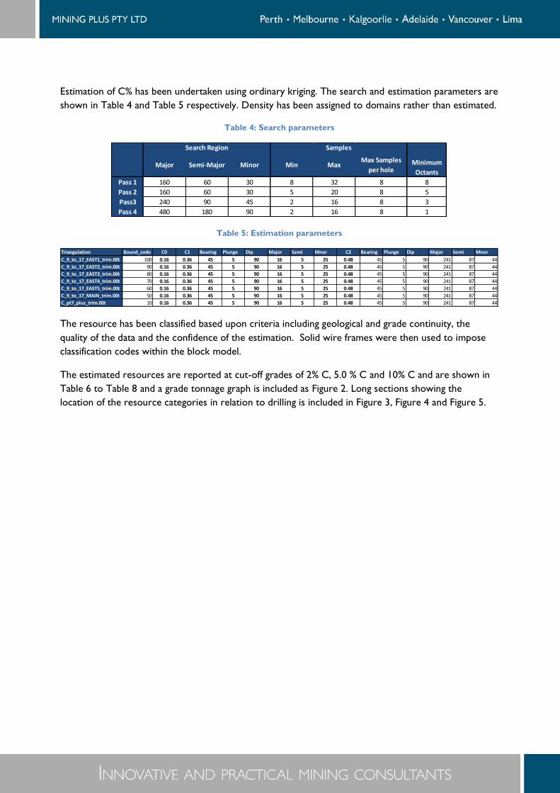
Estimation of C% has been undertaken using ordinary kriging. The search and estimation parameters are
shown in Table 4 and Table 5 respectively. Density has been assigned to domains rather than estimated.
Table 4: Search parameters
Table 5: Estimation parameters
The resource has been classified based upon criteria including geological and grade continuity, the
quality of the data and the confidence of the estimation. Solid wire frames were then used to impose
classification codes within the block model.
The estimated resources are reported at cut-off grades of 2% C, 5.0 % C and 10% C and are shown in
Table 6 to Table 8 and a grade tonnage graph is included as Figure 2. Long sections showing the
location of the resource categories in relation to drilling is included in Figure 3, Figure 4 and Figure 5.
Major Semi-Major Minor Min MaxMax Samples
per hole
Pass 1 160 60 30 8 32 8 8
Pass 2 160 60 30 5 20 8 5
Pass3 240 90 45 2 16 8 3
Pass 4 480 180 90 2 16 8 1
Search Region Samples
Minimum
Octants
Triangulation Bound_code C0 C1 Bearing Plunge Dip Major Semi Mnor C2 Bearing Plunge Dip Major Semi Mnor
C_9_to_17_EAST1_trim.00t 100 0.16 0.36 45 5 90 16 5 25 0.48 45 5 90 241 87 44
C_9_to_17_EAST2_trim.00t 90 0.16 0.36 45 5 90 16 5 25 0.48 45 5 90 241 87 44
C_9_to_17_EAST3_trim.00t 80 0.16 0.36 45 5 90 16 5 25 0.48 45 5 90 241 87 44
C_9_to_17_EAST4_trim.00t 70 0.16 0.36 45 5 90 16 5 25 0.48 45 5 90 241 87 44
C_9_to_17_EAST5_trim.00t 60 0.16 0.36 45 5 90 16 5 25 0.48 45 5 90 241 87 44
C_9_to_17_MAIN_trim.00t 50 0.16 0.36 45 5 90 16 5 25 0.48 45 5 90 241 87 44
C_pt7_plus_trim.00t 10 0.16 0.36 45 5 90 16 5 25 0.48 45 5 90 241 87 44

Table 6: Resource at Campoona Shaft at 2 % C cut-off #
Table 7: Resource at Campoona Shaft at 5.0 % C cut-off #
Table 8: Resource at Campoona Shaft at 10.0 % C cut-off #
# in all resource tables tonnage figures are rounded to the nearest 1000
and SG and grade are rounded to one decimal place.
Figure 2: Tonnage grade graph of combined measured, indicated and inferred
Classification Tonnes SG Grade (%C)
Measured 339,000 2.1 14.8
Indicated 1,059,000 2.1 12.7
Inferred 3,475,000 2.3 5.0
4,873,000 2.2 7.4
2% cutoff
TOTAL
Classification Tonnes SG Grade (%C)
Measured 339,000 2.1 14.8
Indicated 1,056,000 2.1 12.7
Inferred 837,000 2.1 10.7
2,232,000 2.1 12.3
5% cutoff
TOTAL
Classification Tonnes SG Grade (%C)
Measured 336,000 2.1 14.9
Indicated 961,000 2.1 13.1
Inferred 610,000 2.1 12.2
1,907,000 2.1 13.1TOTAL
10% cutoff
Cutoff c_pc_ok Tonnage sg
0 6.11 6168310 2.25
1 6.4 5858474 2.25
2 7.38 4872269 2.23
3 8.83 3748557 2.19
4 10.75 2763619 2.14
5 12.25 2231506 2.09
6 12.71 2093257 2.07
7 12.82 2057660 2.07
8 12.86 2041340 2.07
9 12.96 1993469 2.07
10 13.12 1907112 2.07
11 13.54 1637595 2.07
12 14.14 1267075 2.06
13 14.8 901580.1 2.06
14 15.86 502432 2.06
15 16.83 295664.7 2.06
16 17.56 192383 2.06
17 18.19 117433.5 2.06
18 18.76 59721.55 2.06
19 19.32 18954.2 2.06
20 20.78 216.3 2.06
21 21.53 41.2 2.06
22 0 0 0

Figure 3: Inferred blocks
Figure 4: Indicated blocks
Figure 5: Measured blocks
The information in this report that relates to the resource estimation has been prepared by Mr B Godsmark who is a Member of the AusIMM and peer reviewed by Mr G Reed who is also a Member of the AusIMM (CP). Mr Godsmark is a full time employees of Mining Plus Pty Ltd and Mr Reed is a sub-contractor to Mining Plus Pty Ltd, both have more than five years’ experience which is relevant to the style of mineralisation and type of deposit under consideration and to the activity which they are undertaking to qualify as a Competent Person as defined in the 2004 Edition of the “Australasian Code for Reporting of Exploration Results, Mineral Resources and Ore Reserves”. Mr Godsmark and Mr Reed have consented in writing to the inclusion in this announcement of the mineral resource estimation information in the form and context in which it appears.

1
Memorandum
To: Wade Bollenhagen
Cc:
From: Bruce Godsmark
Date: 5-12-2012
Subject: Campoona Central Resource Estimate
Reference:
The mineral resource estimate presented in this Memo is effective as of 5th December 2012.
Graphite is the target commodity at the Campoona Central Project. The Eyre Peninsula has a
demonstrated history of graphite production as evidenced by the Uley graphite mine west of Port
Lincoln where graphite has been produced. The Uley deposit was discovered in the 1910s and has been
worked intermittently since the late 1920s. Exploration during the 1980s led to reopening the mine in
1986 but a sharp decline in world graphite prices in 1992 saw the operation placed on care and
maintenance in 1993.
The graphite mineralisation at Campoona Central has been drilled over a strike length of 580m. It has a
strike of approximately 45 degrees and is interpreted to dip very steeply (-85 degrees) to the north-
west. Eleven holes have been drilled at Campoona Central and five have intersected graphite
mineralisation. Drilling has been completed on three lines with distances between the lines of 260m ,
140m and 160m. On one line the drilling has demonstrated vertical continuity and the drill holes
intersect the graphite mineralisation 30m apart.
The mineral resource has been calculated using the following software;
Maptek ™ Vulcan ™ 8.1.4 - block modelling,
estimation and Supervisor ™ - geostatistical analysis.
A rotated block model has been used to quantify the tonnage and grade of the Campoona Central
Deposit. The block model origin and dimensions are shown in Table 1 and Table 2 respectively.
Table 1: Block model origin

Table 2: Block dimensions and size
The block model was coded with four 3-D wire frames and two 2-D surfaces as shown in Table 3.
Table 3: Block model coding
Estimation of C% has been undertaken using ordinary kriging. The search and estimation parameters are
shown in Table 4 and Table 5 respectively. Density has been assigned to domains rather than estimated.
Table 4: Search parameters
Table 5: Estimation parameters
The resource has been classified based upon criteria including geological and grade continuity, the
quality of the data and the confidence of the estimation. Solid wire frames were then used to impose
classification codes within the block model.
The estimated resources are reported at cut-off grades of 2% C, 5.0 % C and 10% C and are shown in
Table 6 to Table 8 and a grade tonnage graph is included as Figure 1. A long sections showing the
location of the inferred resource in relation to drilling is included as Figure 2 and a long section showing
the location of the exploration target is shown in Figure 3
Additional exploration target is considered to exist along strike of the existing inferred resource and
this is considered to be in the range of 500,000 to 700,000 tonnes at a grade of 12 % C to 14 % C.
x co-ordinate y-co-ordinate z-co-ordinate Bearing Plunge Dip
634600 6286500 150 135 0 0
Block Model Origin Block Model Rotation
Campoona Central
Scheme
Start x
offset
Start y
offset
Start z
offset
end x
offset
end y
offset
end z
offset
Block x
size
Block y
size
Block z
size
Blocking x
maximum
Blocking y
Maximum
Blocking z
maximum
Parent 0 0 0 1200 1800 300 10 25 20
Sub 0 0 0 1200 1800 300 1 2.5 2 10 25 20
Triangulation Variable Value Priority Triangulation Variable Value Priority
South_C9_C17_E_TRIM_INF.00t geo_code 95 95 South_C9_C17_E_TRIM_INF.00t sg 2.1 95
South_C9_C17_W_TRIM_INF.00t geo_code 85 85 South_C9_C17_W_TRIM_INF.00t sg 2.1 85
South_C5_C9_TRIM_INF.00t geo_code 75 75 South_C5_C9_TRIM_INF.00t sg 2.1 100
South_BM_AREA.00t geo_code 5 5 South_BM_AREA.00t sg 2.3 10
25m_topo.00t litho rock 1 south_base_inferred.00t resource_base_level 0 1
25m_topo.00t litho air 2 south_base_inferred.00t resource_base_level 1 1
Major Semi-Major Minor Min MaxMax Samples
per hole
Pass 1 160 60 30 8 32 8 8
Pass 2 160 60 30 5 20 8 5
Pass3 240 90 45 2 16 8 3
Pass 4 480 180 90 2 16 8 1
Search Region Samples
Minimum
Octants
Triangulation Bound_code C0 C1 Bearing Plunge Dip Major Semi Mnor C2 Bearing Plunge Dip Major Semi Mnor
South_C9_C17_E_TRIM_INF.00t 95 0.16 0.36 45 5 90 16 5 25 0.48 45 5 90 241 87 44
South_C9_C17_W_TRIM_INF.00t 85 0.16 0.36 45 5 90 16 5 25 0.48 45 5 90 241 87 44
South_C5_C9_TRIM_INF.00t 75 0.16 0.36 45 5 90 16 5 25 0.48 45 5 90 241 87 44
South_BM_AREA.00t 5 0.16 0.36 45 5 90 16 5 25 0.48 45 5 90 241 87 44

Table 6: Resource at Campoona Central at 2 % C cut-off #
Table 7: Resource at Campoona Central at 5.0 % C cut-off #
Table 8: Resource at Campoona Central at 10.0 % C cut-off #
# in all resource tables tonnage figures are rounded to the nearest 1000
and SG and grade are rounded to one decimal place.
Figure 1: Tonnage grade graph of combined inferred resource
Figure 2: Inferred resource blocks
Classification Tonnes SG Grade (%C)
Inferred 397,000 2.1 10.1
397,000 2.1 10.1TOTAL
2% cutoff
Classification Tonnes SG Grade (%C)
Inferred 295,000 2.1 12.5
295,000 2.1 12.5TOTAL
5% cutoff
Classification Tonnes SG Grade (%C)
Inferred 274,000 2.1 13.0
274,000 2.1 13.0TOTAL
10% cutoff
Cutoff c_pc_ok Tonnage sg
0 10.13 397656 2.1
1 10.13 397656 2.1
2 10.13 397425 2.1
3 11.17 349660.5 2.1
4 11.94 318118.5 2.1
5 12.53 294882 2.1
6 12.94 278890.5 2.1
7 12.98 277116 2.1
8 12.98 276979.5 2.1
9 12.98 276927 2.1
10 13.02 273640.5 2.1
11 13.17 257701.5 2.1
12 13.76 187204.5 2.1
13 14.79 104128.5 2.1
14 15.44 69090 2.1
15 16.06 42378 2.1
16 16.62 20107.5 2.1
17 17.38 4273.5 2.1
18 18.22 115.5 2.1
19 0 0 0

Figure 3: Exploration Target
The information in this report that relates to the resource estimation has been prepared by Mr B Godsmark who is a Member of the AusIMM and peer reviewed by Mr G Reed who is also a Member of the AusIMM (CP). Mr Godsmark is a full time employees of Mining Plus Pty Ltd and Mr Reed is a sub-contractor to Mining Plus Pty Ltd, both have more than five years experience which is relevant to the style of mineralisation and type of deposit under consideration and to the activity which they are undertaking to qualify as a Competent Person as defined in the 2004 Edition of the “Australasian Code for Reporting of Exploration Results, Mineral Resources and Ore Reserves”. Mr Godsmark and Mr Reed have consented in writing to the inclusion in this announcement of the mineral resource estimation information in the form and context in which it appears.
Top Related