


Languages
Pages
Legal


46th Annual Conference of the Australian Agricultural and Resource Economics
Society
Canberra, 13-15 February 2002
Assessing Water Sharing Rules in Unregulated Rivers in NSW: Mooki River
Aluwihare, P.B., Crean, J., Young, R.T
Economic Services Unit, NSW Agriculture1
The new Water Management Act (2000) requires water to be specifically allocated for
environmental purposes to try to improve river health. Water sharing plans are being
developed which establish extractive and environmental shares to river flows. A key
consideration in the development of these plans is the economic trade-offs associated
with different allocation options. In unregulated catchments, allocation rules typically
involve significant restrictions to extractive access at times of low river flows, which
also coincides with periods of environmental stress.
The highly variable nature of stream flows in unregulated catchments creates
challenges not only to the development of plausible sharing rules but also to the
assessment of their effects. In this paper proposed water sharing rules in the Mooki
sub-catchments in Northern NSW is examined. A combination of representative farm
(linear programming) and hydrology simulation modelling is used to explore these
effects.
Key words: flow sharing rules, modelling, farm-level economic impacts.
�
The views expressed in this paper are of the authors and not necessarily those of NSW Agriculture or
the New South Wales Government

Assessing water sharing rules in unregulated rivers
46th
Annual AARES Conference
1
1. Introduction
Water policy reform has received considerable attention in recent years. This is due
to growing community concerns regarding environmental degradation in rivers and
wetlands, increasing evidence of the poor state of land resources in irrigation areas
and a greater government focus on improving the economic efficiency of water
allocation. Significant reforms to regulated rivers (those where flows are regulated by
major irrigation storages) and groundwater resources have been under way for several
years (Crean and Young 2001). The NSW Government is now implementing a suite
of reforms to the management of unregulated rivers.
In unregulated rivers across New South Wales (NSW), the absence of an efficient set
of rights governing access to water is one of the main factors contributing to a decline
in river health and preventing an improvement in the efficiency of water use. The
deterioration of stream health, decline in the condition of riparian vegetation, damage
to the habitat of threatened species and a decline in water quality (increase in salinity,
turbidity, and decline in dissolved oxygen) are the main environmental problems
found in unregulated rivers (DLWC 2001a). These problems are caused mainly by
the extraction of water during low and moderate flows. Natural low flows are
important for maintaining pool connectivity, minimising stagnation and stratification
of pools, and preventing concentration of pollutants (DLWC 2001a). Maintenance of
pools during dry periods is also critical for the survival of fish and aquatic species.
Excessive extraction of moderate flows affects the distribution of food and
transportation of sediments, nutrients and organic carbon downstream. Moderate
flows are also important for de-stratification of pools.
In addition to improving environmental outcomes, improving economic efficiency
and equity has emerged as a major issue in water management as competition for
surface water has increased. However, the absence of a clear specification of water
access rights has been a major barrier for the efficient management of water in the
unregulated rivers of NSW.

Assessing water sharing rules in unregulated rivers
46th
Annual AARES Conference
2
The NSW government is currently addressing this poor specification of property
rights through the development of a suite of water sharing plans for each unregulated
river in the state. These are being developed by community based River Management
Committees (RMCs) and detail the way water is to be shared between the
environment, irrigators and other users.
Twelve environmental objectives have been established as a basis for the
development of water sharing plans (DLWC 2001b). These include the need to better
mimic natural flow variability and protect low and moderate flows. While the
economic benefits associated with these environmental improvements may be high,
changing the flow access rules may also impose significant costs on existing
irrigators. Therefore, in developing socially acceptable flow access rules the
committees need to consider trade-offs between water for the environment and for
other users. Natural resource management agencies, like NSW Agriculture, provide
support to RMCs in developing their water sharing plans. This includes assistance in
assessing the socio-economic trade-offs associated with various sets of river flow
access rules.
NSW Agriculture has provided a number of reports to RMCs evaluating trade-offs for
regulated rivers and for groundwater aquifers (Carter et al. 2000; Jayasuriya and
Crean 2000, 2001; Jayasuriya et al. 2001). However, the approaches developed for
regulated rivers and groundwater cannot be directly applied for unregulated rivers.
This is because of the highly variable nature of river flows, within and between years
and the complicated rules regarding flow extraction and application to crops. In this
paper a methodology developed to assess the on-farm impacts of flow rules for
unregulated rivers in NSW is discussed. This is done by reference to a study
undertaken for the Namoi Unregulated River Management Committee (NURMC) of
the Mooki Catchment in northern NSW.
The paper is structured as follows. Section 2 provides background information about
the Mooki Catchment. Flow rules developed for the Mooki by the NURMC are
outlined in Section 3. Section 4 contains a discussion of possible methodological
approaches for assessing the impacts of water sharing rules in unregulated catchments

Assessing water sharing rules in unregulated rivers
46th
Annual AARES Conference
3
and the approach adopted in this study. Section 5 presents the results. Finally, a
discussion and conclusion are presented in Section 6.
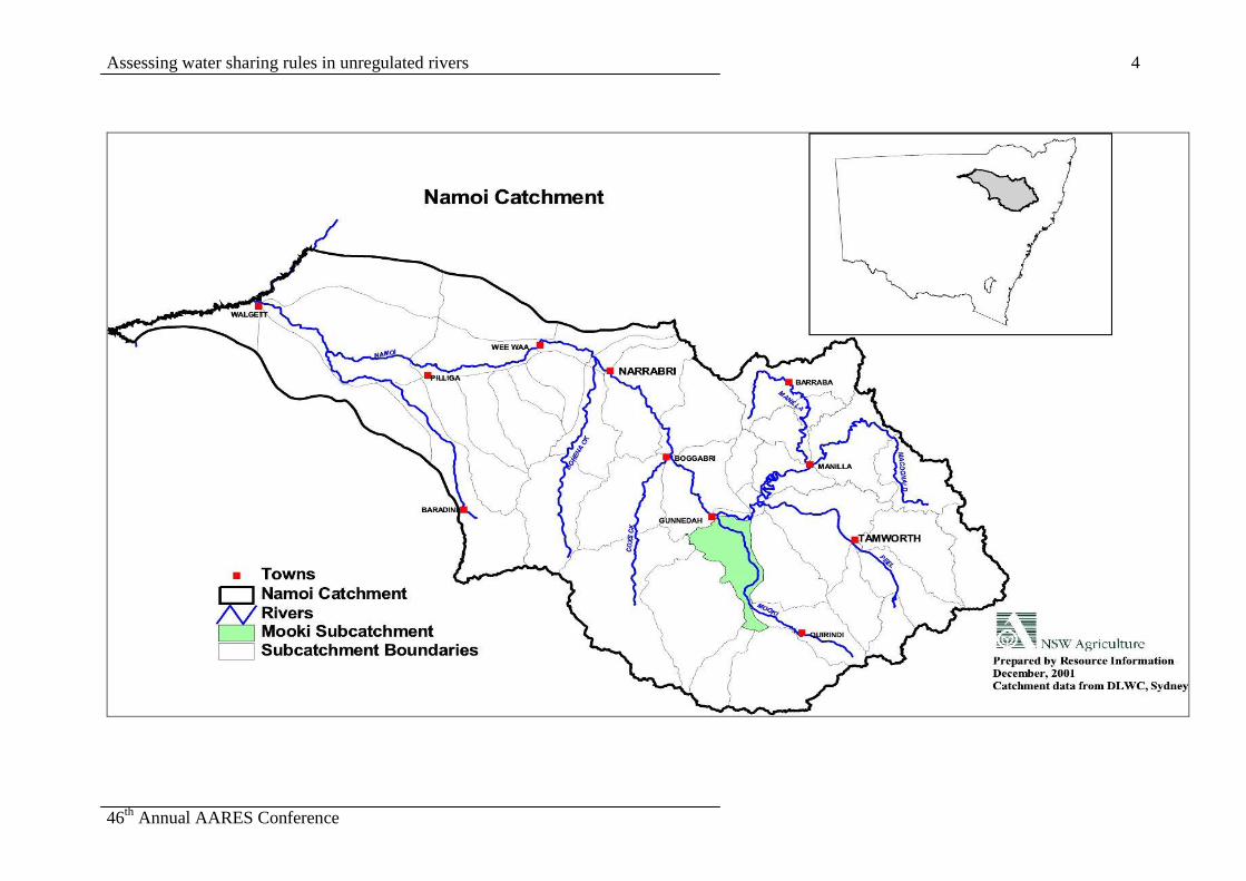
2. The Mooki Sub-Catchment
The Mooki sub-catchment lies at the eastern end of the Namoi Valley located in
Northern NSW (Figure 1). The Mooki sub-catchment covers an area of about 840
square kilometers which is about 2 per cent of the Namoi Catchment area. Irrigated
agriculture is an important contributor to the regional economy of the Namoi Valley.
The value of irrigated agricultural production was around 290 million dollars in 1997
(NSW Agriculture 2001a). The Mooki sub-catchment was settled by European
graziers in the 1830s. Dryland cropping progressively expanded on the black alluvial
soils of the flood plain during the first half of the last century. Irrigation development
began in 1965 which also focused on the black alluvial soils of the flood plain.
Currently there are 23 irrigators licensed to extract water from the Mooki River.
About 50 percent of these have access to surface water only while the remainder has
access to both surface and groundwater. The total area authorised for irrigation using
surface water is around 3,500 ha. Currently, around 2,900 hectares have been
developed for irrigation (Powell 2001).
The irrigated agricultural enterprises in the Mooki sub-catchment include cotton,
wheat, maize, summer oilseeds and vegetables. Over the past two decades, the area of
cotton has expanded rapidly reflecting its relative profitability. Cotton and wheat
account for around 70 and 20 per cent of the irrigated area, respectively. Back to
back cotton and a cotton-wheat rotations are the most common practices in the
catchment. Furrow irrigation is the predominant irrigation method for all crops,
although there is some spray irrigation in the upper sub-catchment. Most irrigated
farms also have a dryland farming component. Sorghum and wheat are the most
commonly grown dryland crops in the catchment.
Assessing water sharing rules in unregulated rivers
46th
Annual AARES Conference
4

Assessing water sharing rules in unregulated rivers
46th
Annual AARES Conference
5
2.1. River flows
The Mooki River is dependent on inflows from the Phillip, Warrah and Quirindi water
sources as well as localised rainfall in the Mooki sub-catchment. The Mooki River
displays a highly variable flow pattern. The daily pattern of flow for a typical year is
detailed in Figure 2. While the median daily flow is 10 MLs, it ranges from 0 to over
50,000 MLs. Due to the highly variable flow pattern and the small number of days on
which flow is available for extraction (around 35 percent of the time) on-farm water
storages are essential for ensuring irrigation availability throughout the irrigation
season.
Figure 2. Daily flow in the Mooki River, 1989
Note: The daily flows during days 291 to 351 have been truncated in order to present
a reasonable scale for other flow events. Actual daily flows reached maximum of
4,500 MLs.
0
500
1000
1500
2000
2500
3000
1 11 21 31 41 51 61 71 81 91101
111121
131141
151161
171181
191201
211221
231241
251261
271281
291301
311321
331341
351361
Day
MLs

Assessing water sharing rules in unregulated rivers
46th
Annual AARES Conference
6
3. Rules for Sharing River Flows
3.1 Current Flow Sharing Rules
Currently, irrigation licences are based on the area irrigated irrespective of the volume
of water used. A “Commence to Pump”(CTP) threshold establishes the minimum
flow level that the river must reach before irrigators can start their pumps. This rule
aims to protect low flows and allow flow to build up to levels useful for irrigators in
down stream river reaches. In the Mooki sub- catchment one CTP level has been set
at 50 MLs/day.
3.2 Proposed Flow Sharing Rules
Under the Water Management Act 2000, all area based licences are being converted to
a volumetric basis to better define irrigators’ access rights, to encourage improved
irrigation efficiency and to facilitate trade. Volumetric entitlements have been
established by looking at the historical area of each crop type irrigated for each
irrigator. These areas were then multiplied by the theoretical water requirement for
each crop type for that climatic zone (different climatic zones were established across
the state).
In addition to an annual volume limit, flow variability requires a mechanism by which
each flow event can be shared between irrigators, the environment and others users.
A generic approach has been developed across the state to divide river flows into four
categories. These are based on a flow duration curve (Figure 3) and are defined as
follows:
1. Basic low flows - very low flows not available for extraction. As a general rule
flows exceed this level for 95 percent of days (the 95th
percentile).
2. Class A - low flows generally between the 95th
and 80th
percentile.
3. Class B - low to moderate flows generally between the 80th
and 50th
percentile.

Assessing water sharing rules in unregulated rivers
46th
Annual AARES Conference
7
4. Class C - moderate to high flows, freshes and floods. Refers to flows generally
between the 50th
and 0 percentile (flows exceed this level less than 50 per cent of
the days).
Irrigators are permitted to extract a proportion of flows in each flow class. The
proportion is determined for each river and is usually based on historical extraction
levels. The volume of water allowed for extraction by irrigators determined by this
method is called the “Bulk Extraction Volume” (BEV). Water management
committees in unregulated rivers have been determining the daily share of water
between extractive users and the environment through establishment of BEVs for
different flow classes.
In the case of the Mooki River, A and B class flows do not exist due to the highly
ephemeral nature of the stream (Powell, 2001). Given the high demand for river
flows, Class C flows have been further divided into three sub-classes (C1, C2 and
C3). Three flow sharing options were proposed by the Namoi Unregulated River
Management Committee (NURMC) for sharing river flows within these classes (see
Powell, 2001) which are summarised in Table 1.
Figure3. Flow duration curve for the Mooki River
Source: DLWC (2001a)
0
100
200
300
400
500
600
700
800
900
1000
0 5 10 15 20 25 30 35 40 45 50 55 60 65 70 75 80 85 90 95 100
% of time flow is exceeded
Meg
ali
tres
per
da
y
Class AClass B
Class C
Basic low
flows

Assessing water sharing rules in unregulated rivers
46th
Annual AARES Conference
8
The current rules represent the ‘base case’ against which the proposed flow sharing
options are compared. Under the base case, irrigators could access all river flows
above the CTP level (50 MLs/day). In practice irrigators only extract a proportion of
flows because of limits on pump and on-farm storage capacities. There is effectively
no BEV currently in place.
Table 1. Proposed flow sharing options in the Mooki
Flows class Flow level
MLs/day
Bulk Extraction Volume (MLs)
Option 2A Option 2B Option 3
CTP 100 Nil Nil Nil
C 1 100 - 1,000 800 600 600
C 2 1,000 – 3,000 1,500 1,500 900
C 3 > 3,000 2,100 2,100 2,100
The flow sharing Options (2A, 2B, and 3) provided in Table 1 impose varying levels
of restriction on the amount of water which can be extracted by irrigators within C1
and C2 classes. Access to C3 class flows is constant across all flow sharing options.
The BEV is distributed among individual irrigators in proportion to their licensed
entitlement but is restricted by physical ability to extract water. Individual flow
extraction will continue to depend on pump capacity and the size of on-farm storage.
Some additional rostering arrangements may be established by irrigators to ensure
equitable access to the resource given the differing location of individual farms along
the river. Currently, no rostering rules are practiced with upstream irrigators getting
first access to each flow. In the absence of any existing rostering arrangement, some
assumptions were made about how water was shared among individuals. These are
outlined in section 4.

Assessing water sharing rules in unregulated rivers
46th
Annual AARES Conference
9
4. Methodology
4.1 Overview
Water policy reforms generally involve some form of modification of property rights
involving a re-allocation of resources. Resource re-allocation decisions are commonly
assessed in a benefit-cost framework. The economic efficiency of different allocation
policies can be assessed by comparing the social benefits and costs associated with
each policy. Underpinning the benefit-cost framework the ‘potential Pareto
improvement’ criterion states that resource re-allocation decisions are efficient if
those who are made better off can compensate those who are made worse off and still
be in a better situation. Of course, for the criterion to be satisfied it is not necessary
for compensation to be actually paid.
There are, however, a number of difficulties associated with adopting the standard
benefit cost analysis framework when considering issues that are likely to yield
environmental benefits, like increased water allocations to the environment. The
major difficulty relates to the appropriate valuation of environmental benefits
(particularly those in the non-use category) so that they can be incorporated into a
benefit-cost framework. To overcome some of the conceptual arguments regarding
valuation, a variation on the standard benefit cost framework can be adopted through
the use of an ‘opportunity cost’ or ‘threshold value’ approach. The threshold value
approach avoids the need to directly place monetary values on environmental goods.
The approach is based upon estimating the ‘opportunity costs’ which would be the
consequence of a particular resource decision. The opportunity costs are then directly
compared to the environmental outcomes (quantified in non monetary terms) which
are expected from the proposal.
The impacts on irrigated agriculture of water reforms can be analysed at two levels.
The first at a broader regional scale, and second at a more disaggregated catchment or
farm level. The latter approach is adopted in this study. There is a range of techniques
available for assessing farm level impacts of water policy reforms. These techniques
range from simple budgeting methods to optimisation methods. However, the

Assessing water sharing rules in unregulated rivers
46th
Annual AARES Conference
10
selection of the method depends ultimately on the purpose of the analysis and the
nature of the problem being addressed.
The community based approach to the implementation of water reforms provides the
overall context for farm level analyses undertaken by NSW Agriculture. The purpose
of quantitative work within this context is to facilitate social choice. More
specifically, it is to provide information to help RMCs understand how the farm level
financial impacts of water sharing options are distributed so that appropriate trade-
offs can be made. The central role that RMCs have in the process and their broad
community representation (with varying levels of understanding of economics)
suggests that relatively straightforward methodological approaches should be used.
Methodological approaches should meet simplicity and transparency requirements
whilst also remaining sufficiently rigorous to capture real effects.
The types of problems proposed by RMCs commonly involve some form of
restriction to the access of water resources. The significance of these restrictions will
depend on climatic conditions that influence both the availability of river flow for
extraction and water demand. When climatic variability is likely to influence the
relative effects of water management options, then more stochastic methodologies are
required (eg. simulation).
NSW Agriculture has adopted various representative farm modelling methods to
analyse the on-farm impacts of re-allocation of water in NSW catchments. Cater et al.
(2000) adopted a simple whole farm budgeting method to estimate benefits or farm
returns for analysing the on-farm impacts of groundwater re-allocation rules in the
Namoi Valley. However, in estimating net farm returns this method elicited farmer
response to changed water availability directly from the farmers concerned. Many of
these responses were found to be irrational, designed more to influence policy
outcomes of the study, rather than accurately reflecting rational farmer behaviour. As
such they did not optimise resource allocation or minimise risk.
Modelling at a catchment and farm level is a widely used approach analysing
problems in agriculture and water resource management (Crean et al. 2001).
Catchment level modelling considers differentiated agriculture demand sites
(agricultural production zones or nodes) where each agricultural demand site can be

Assessing water sharing rules in unregulated rivers
46th
Annual AARES Conference
11
modelled as a single farm. Farm scale modelling is done by selecting a representative
farm or farms depending on the variability of farm characteristics in the catchment.
NSW Agriculture has adopted farm scale modelling to evaluate the on-farm impacts
of environmental flow rules in regulated river catchments in NSW (Jayasuriya and
Crean 2000; Jayasuriya et al. 2001). However, these models cannot be applied
directly to unregulated rivers because they use total seasonal water availability instead
of weekly or daily water availability. In addition, the reliance on on-farm storages by
irrigators on unregulated rivers further complicates the modelling of water balance
and irrigator behaviour. Modelling of irrigation on unregulated rivers therefore needs
to consider the dynamic nature of water management within the economic model.
4.2. The Approach
This study adopted a combination of hydrology simulation and linear programming
(LP) to evaluate alternative flow sharing options in the Mooki sub-catchment. The
principle reason for adopting a simulation approach was to consider the variability of
impacts due to the nature of stream flows and climatic conditions. Historical rainfall
and stream flow data indicate that the Mooki sub-catchment is a highly variable
system (see Figure 2). This suggests that using a deterministic or average year
analysis would not adequately represent the farm level impacts of different flow
sharing options because changes in river flow availability directly impact on the area
of irrigated crops and hence farm returns.
It is assumed that farmers respond to reductions in water availability by changing
their crop mix to make the best use of available water and convert part of the area laid
out for irrigation to dryland production. The income from this area will be estimated
by the gross margin for an equivalent area of dryland crop. The model assumes that
daily BEV is perfectly shared by all irrigators. The approach is shown schematically
in Figure 4. The hydrology simulation and farm level optimisation models are
discussed in the following sections.

Assessing water sharing rules in unregulated rivers
46th
Annual AARES Conference
12
Figure 4. Schematic of the modelling approach
4.2. Stream flow simulation model (Sacramento model)
The Sacramento model was used by DLWC to simulate stream flows. It is a
continuous rainfall-runoff model that generates stream flows from rainfall and
evaporation records. The principle of the model is that it uses soil moisture
accounting to simulate the water balance within the catchment.
4.3. Farm level optimisation model
A single representative farm was used in the analysis to represent all irrigators who
have access to surface water entitlements. This was done for two reasons. First,
because the homogeneous nature of farming systems in the sub-catchment. Cater et
al. (2000) undertook a GIS analysis of farm size and various attributes, such as
irrigation entitlement and on-farm storage size and found that these attributes to be
relatively homogeneous. Key features of the representative farm were based on
information derived from earlier irrigation surveys and advice from local irrigators
and advisory staff. The main characteristics of the representative farm are provided in
Table 2. Overhead costs for the representative farm were derived from a survey
conducted of 22 irrigators in the Mooki and Cox's Creek catchments for an MDBC
project by Bennett and Bray (2001).
Sacramento Hydrology
Model
– Generate stream
flow data for 88 years
Individual daily
flow shares
Flow rules
Farm level
Optimisation Model

Assessing water sharing rules in unregulated rivers
46th
Annual AARES Conference
13
Some of the key economic data used in the economic model are discussed below:
Gross margins – gross margins of crops used in the model were obtained from the
Farm Enterprise Budgets for Northern NSW (NSW Agriculture 2001b). Gross
margins are estimated in year 2000 prices.
Overhead costs for the representative farm include costs such as wages for
permanent labour, administration costs, capital depreciation, etc.
Cost of water includes pumping costs and water charges.
Table 2. Key features of the representative farm.
Key physical characteristics
Total farm size (Ha) 442
Surface irrigated area (Ha) 162
Dry land area (Ha) 280
On-farm storage size (MLs) 729
Pump capacity MLs/day 125
Surface water entitlement (ML) 1,294
Irrigated crop mix (%)
Irrigated Wheat 25%
Irrigated Cotton 61%
Irrigated Maize 14%
Dry land crop mix (%)
Wheat 50%
Sorghum 50%
Farm overhead costs $75,500
The objective function of the farm level optimisation model is to maximise total
annual net farm income, Z, which is given by,
KAcZMax ii
n
i
.
Subject to:
LAa jiij
n
i
1

Assessing water sharing rules in unregulated rivers
46th
Annual AARES Conference
14
Where:
Z is annual total net farm income,
c is gross margin per unit area of land for crop i,
A is area cultivated under crop i,
K is the total annual overhead cost for the farm,
a is the amount of resource j used per unit of crop i,
L is the maximum availability of resource j.
Net farm income is a measure of farm profit and measures the return to the operator
for their labour and management and return to all capital investment on the farm. The
model considered number of resource constraints. Constraints on production
resources were monthly water availability and annual water entitlement and land laid
out for irrigation and dryland area. The other constraints were specific crop
constraints, pump capacity, and on-farm storage capacity. A capital constraint is
embedded in the specific crop constraints. A cotton-wheat crop rotation was specified
given it is the most commonly practiced crop rotation in the area.
Monthly flow availability for extraction was estimated by aggregating the daily
extractable flow. Daily extractable flow was estimated by proportionally allocating
daily BEV based on annual entitlement (pro rata basis). The model assumes all river
water is routed through the on-farm storage before being applied to crops. This
irrigation flow path requires a series of equations to represent the water availability
constraint. These include an on-farm storage water balance equation and an on-farm
storage capacity constraint.
On-farm storage water balance
The on-farm storage water balance is governed by the on-farm storage continuity
equation. The linear equation representing the continuity equation is as follows:
eWSS tttt 11

Assessing water sharing rules in unregulated rivers
46th
Annual AARES Conference
15
Where:
St is the amount of water stored in time t,
It is the amount of water pumped into storage in time t,
Wt-1 is the amount of water released from the storage for irrigation in time t-1,
et is the storage losses in time t (evaporation and seepage).
The storage capacity constraint is as follows
CS t
Where, C is the capacity of the on-farm storage.
Estimation of crop demand (gross irrigation demand) was an important part of
estimating the model coefficients needed to determine monthly storage release. The
following equation was used to estimate monthly irrigation requirements.
IR = ETc – ERF – RSM + PI
GIR = IR * IE
Where,
IR is the irrigation requirement at root zone,
ETc is the crop evapo-transpiration,
ERF is the effective rainfall,
RSM is the residual soil moisture at the time of planting,
PI is the pre-irrigation requirement.
GIR is the gross irrigation requirement (ex on-farm storage),
IE is the irrigation efficiency (conveyance and application).
Since data was not available, residual soil moisture and pre-irrigation requirements
were not considered in the estimation. Crop ET (ETc) values were estimated by NSW
Agriculture’s Water Use Efficiency Unit using the Penmann and Monteith method
were used in estimating crop water requirements (NSW Agriculture 2001c). Effective
rainfall for each crop was estimated using monthly rainfall multiplied by crop
effectiveness factors. Gross irrigation requirement was estimated at 70 per cent

Assessing water sharing rules in unregulated rivers
46th
Annual AARES Conference
16
irrigation efficiency. Since the estimated GIR is a theoretical one, a factor (0.3 ) was
used to scale it down to represent more realistic irrigation requirements. The scaling
factor was determined by comparing the estimated GIR and irrigator reported GIR.
The irrigators generally under irrigate by 30 per cent compared to theoretical crop
water requirements (NSW Agriculture 2001b). This under irrigation is reflected in
the yields used in the analysis.
5. Results
5.1. Impact on average net farm income
The financial impacts of flow sharing options using the farm level modelling
approach are provided in Table 3. From the results it can be seen that the introduction
of Options 2A, 2B and 3 are expected to result in a decrease in net farm income of
5.0%, 5.1% and 5.9%, respectively. All three Options will have statistically
significant impact on irrigators. While there was no statistically significant difference
in impacts between Options 2A and 2B, the restriction in access to C2 class flows
under Option 3 reduce farm performance to a greater degree.
Table 3. Summary of impacts using the representative farm model with river flow data
Current Rule Rule 2A Rule 2B Rule 3
Whole Farm Gross Margin (WFMG)
- Average ($)
- Standard deviation ($)
278,284
17,737
268,209
28,935
267,928
29,020
266,396
30,196
Net Farm Income (NFI)
- Average ($)
- Standard deviation ($)
202,784
17,737
192,709
28,935
192,428
29,020
190,896
30,196
Impact on WFGM % -3.6 -3.7 -4.3
Impact on NFI % -5.0 -5.1 -5.9
T-test results( Comparing means against
the mean of current rule), at 5%
2.78 2.85 3.18

Assessing water sharing rules in unregulated rivers
46th
Annual AARES Conference
17
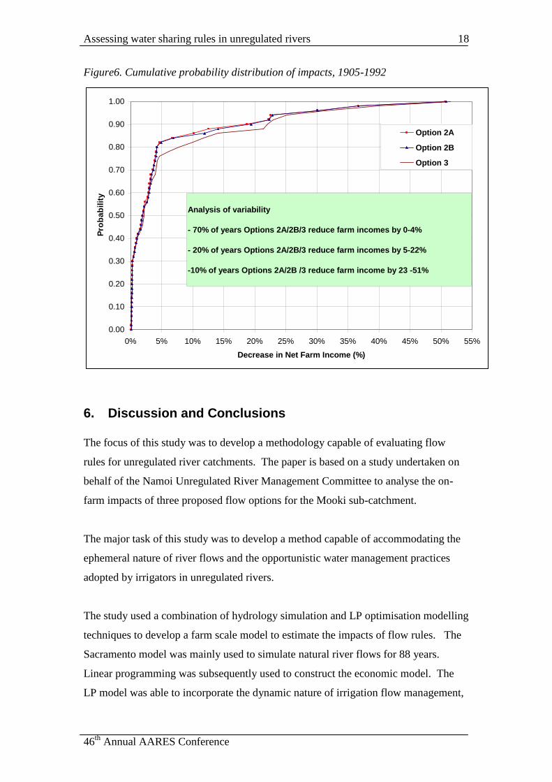
5.2. Distribution of impacts across years
Figure 5 illustrates the impacts of flow sharing options across the 88-year simulation
period. This shows that impacts are higher in dry years. However, the incidence of
impacts is complicated by the operation of the on-farm storage (OFS), the timing of
river flows and the subsequent effect of the flow sharing rules on BEV's.
Consequently, impacts occur only in a proportion of dry years. The non-normal
distribution of impacts of flow sharing options is reflection of the non-normal river
flow pattern. Standard statistic theory suggests that, under a non-normal distribution,
a comparison of means may only lead to false conclusions. Analysis of the
distribution of impacts of different water sharing options was therefore undertaken
using cumulative probability distribution function (CDF) as suggested by Anderson et
al. (1977).
Figure 6 provides a summary of results in the form of cumulative distribution
functions (CDFs). This shows that for around 70 percent of the years, Option 2A, 2B
and 3 are expected to reduce farm incomes by 0-4%. For around 20 per cent of time
incomes may fall by 5-22%, and for around 10 per cent of years they are expected to
fall by between 23-51%.
Figure 5. Impact of flow sharing options, 1905-1992
0%
10%
20%
30%
40%
50%
60%
1905 1909 1913 1917 1921 1925 1929 1933 1937 1941 1945 1949 1953 1957 1961 1965 1969 1973 1977 1981 1985 1989
Year
Dec
reas
e in
Net
Far
m I
nco
me
($)
Option 2A
Option 2B
Option 3
Assessing water sharing rules in unregulated rivers
46th
Annual AARES Conference
18
Figure6. Cumulative probability distribution of impacts, 1905-1992
6. Discussion and Conclusions
The focus of this study was to develop a methodology capable of evaluating flow
rules for unregulated river catchments. The paper is based on a study undertaken on
behalf of the Namoi Unregulated River Management Committee to analyse the on-
farm impacts of three proposed flow options for the Mooki sub-catchment.
The major task of this study was to develop a method capable of accommodating the
ephemeral nature of river flows and the opportunistic water management practices
adopted by irrigators in unregulated rivers.
The study used a combination of hydrology simulation and LP optimisation modelling
techniques to develop a farm scale model to estimate the impacts of flow rules. The
Sacramento model was mainly used to simulate natural river flows for 88 years.
Linear programming was subsequently used to construct the economic model. The
LP model was able to incorporate the dynamic nature of irrigation flow management,
0.00
0.10
0.20
0.30
0.40
0.50
0.60
0.70
0.80
0.90
1.00
0% 5% 10% 15% 20% 25% 30% 35% 40% 45% 50% 55%
Decrease in Net Farm Income (%)
Pro
ba
bil
ity
Option 2A
Option 2B
Option 3
Analysis of variability
- 70% of years Options 2A/2B/3 reduce farm incomes by 0-4%
- 20% of years Options 2A/2B/3 reduce farm incomes by 5-22%
-10% of years Options 2A/2B /3 reduce farm income by 23 -51%

Assessing water sharing rules in unregulated rivers
46th
Annual AARES Conference
19
where irrigators need to optimise flow extraction and on-farm storage to maximise
farm returns.
The model was successful in predicting impacts in different flow and climatic years
and was therefore seen as helpful in assessing the impacts of flow options developed
by the NURMC. The model can also be used to predict optimal on-farm storage
capacities for different annual volumetric flow extraction limits. This can be done by
varying the on-farm storage capacity for a given annual flow extraction limit
(entitlement). This output can then be incorporated in a cost benefit analysis to
identify optimal storage capacity.
As with many models this model also makes a number of simplifying assumptions.
The assumption of the flow path – from river to on-farm storage to crop– is not the
only way of irrigation practiced in unregulated rivers. For example, irrigators may
irrigate by directly pumping water from the river onto crops. When this occurs, this
model may underestimate net farm income, thereby over estimating the impacts of
changes in flow rules. The other assumption of this model is that it models irrigation
monthly irrigation rather than more frequently as would be practiced by irrigators.
This assumption also tends to under estimate the magnitude of impacts.

Assessing water sharing rules in unregulated rivers
46th
Annual AARES Conference
20
References
Anderson, J. R., Dillon, J. L., and Hardaker, B.J., 1977, Agricultural Decision
Analysis, Iowa State University, Iowa.
Bennett, R. L and Bray, S., 2001, Summary of responses to Murray Darling Basin
Commission (MDBC) Project No. 19002, Irrigation Futures Framework Modelling,
Breeza Plains Farmer Survey, NSW Agriculture, Gunnedah.
Carter, A., Crean, J. and Young, R. 2000, Impacts of Ground Water Re-allocation
options in the Namoi Valley, NSW Agriculture, Orange.
Crean, J. and Young, R., 2001, “Modelling the farm level implications of water
reforms in NSW, Australia”, invited to ACIAR water policy workshop, Bangkok,
June.
Crean, J., Jayasuriya, R. and Jones, R., 2001, “Regional agricultural implications of
environmental flows in the Murrumbidgee Valley, Australia”, invited paper to
ACIAR water policy workshop, Bangkok, June.
DLWC, 2001a, Water Sharing Plans for the Unregulated Phillip, Mooki, Quirindi
and Warrah, Department of Land and Water Conservation, Tamworth.
DLWC, 2001b, Advice to Water Management Committees, No 6, Water extraction
volumes and daily flow shares in unregulated rivers, Department of Land and Water
Conservation, Sydney.
Jayasuriya, R., Crean, J., 2000, The on-farm impacts of ground water management
scenarios in the lower Murrambidgee, NSW Agriculture, Orange.
Jayasuriya, R., Crean, J., 2001, The on-farm impacts of environmental flow rules in
the Lachlan Valley, NSW Agriculture, Orange.

Assessing water sharing rules in unregulated rivers
46th
Annual AARES Conference
21
Jayasuriya, R., Crean, J. and Hanna, R., 2001, Economic assessment of water charges
in Lachlan Valley, NSW Agriculture, Orange.
NSW Agriculture, 2001a, The Draft Namoi Catchment Irrigation Profile, Water Use
Efficiency and Advisory Unit, NSW Agriculture, Dubbo
NSW Agriculture, 2001b, Farm Enterprise Budgets, NSW Agriculture, Tamworth.
NSW Agriculture and Department of land and Water Conservation, 2001c,
Volumetric Conversion of Irrigation Licences on Unregulated Rivers: Theoretical
Determination of Annual Volumetric Entitlements, NSW Agriculture, Dubbo.
Powell, S., 2001, The Draft Interim Flow Access Rules: Mooki sub-catchment. A
report to the Namoi Unregulated River Management Committee, DLWC, Tamworth.
Top Related