


Languages
Pages
Legal

APPENDIX J
Scenic Report
Mitsubishi Cement Corporation
South Quarry
San Bernardino National Forest
Prepared by:
Lilburn Corporation
1905 Business Center Drive
San Bernardino, CA 92408
July 2011
Mono Basin National Fo
USDA Forest Service MCC South Quarry Scenic Report
i
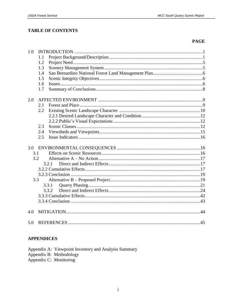
TABLE OF CONTENTS
PAGE
1.0 INTRODUCTION ...............................................................................................................1
1.1 Project Background/Description .................................................................................1
1.2 Project Need ................................................................................................................5
1.3 Scenery Management System .....................................................................................5
1.4 San Bernardino National Forest Land Management Plan...........................................6
1.5 Scenic Integrity Objectives .........................................................................................6
1.6 Issues ...........................................................................................................................6
1.7 Summary of Conclusions ............................................................................................8
2.0 AFFECTED ENVIRONMENT ..........................................................................................9
2.1 Forest and Place ..........................................................................................................9
2.2 Existing Scenic Landscape Character ......................................................................10
2.2.1 Desired Landscape Character and Condition ...................................................12
2.2.2 Public’s Visual Expectations ...........................................................................12
2.3 Scenic Classes ...........................................................................................................12
2.4 Viewsheds and Viewpoints .......................................................................................15
2.5 Issue Indicators .........................................................................................................16
3.0 ENVIRONMENTAL CONSEQUENCES ........................................................................16
3.1 Effects on Scenic Resources .....................................................................................16
3.2 Alternative A – No Action ........................................................................................17
3.2.1 Direct and Indirect Effects ...............................................................................17
3.2.2 Cumulative Effects....................................................................................................17
3.2.3 Conclusion ................................................................................................................19
3.3 Alternative B – Proposed Project ..............................................................................19
3.3.1 Quarry Phasing.................................................................................................21
3.3.2 Direct and Indirect Effects ...............................................................................24
3.3.3 Cumulative Effects....................................................................................................42
3.3.4 Conclusion ................................................................................................................43
4.0 MITIGATION....................................................................................................................44
5.0 REFERENCES ..................................................................................................................45
APPENDICES
Appendix A: Viewpoint Inventory and Analysis Summary
Appendix B: Methodology
Appendix C: Monitoring

USDA Forest Service MCC South Quarry Scenic Report
ii
TABLE OF CONTENT
PAGE
LIST OF FIGURES
Figure 1 Regional Map .................................................................................................................2
Figure 2 Location Map..................................................................................................................3
Figure 3 Existing Quarries and Planned Operations (Aerial) ......................................................4
Figure 4 Scenic Integrity Objectives.............................................................................................7
Figure 5 Desert Rim Place within the SBNF and the Proposed Project Site ..............................11
Figure 6 Potential Viewshed of Proposed Project within SBNF Lands .....................................13
Figure 7 Alternative A – No Project ...........................................................................................20
Figure 8 Viewpoint Locations ....................................................................................................25
Figure 9A Viewpoint 1 ...............................................................................................................28
Figure 9B Viewpoint 1 ...............................................................................................................29
Figure 9C Viewpoint 1................................................................................................................30
Figure 10A Viewpoint 2 ............................................................................................................32
Figure 10B Viewpoint 2..............................................................................................................33
Figure 10C Viewpoint 2..............................................................................................................34
Figure 11A Viewpoint 3 .............................................................................................................35
Figure 11B Viewpoint 3..............................................................................................................36
Figure 11C Viewpoint 3..............................................................................................................37
Figure 12 Viewpoint 4 ................................................................................................................39
Figure 13 Viewpoint 5 ................................................................................................................40
Figure 14 Viewpoint 6 ................................................................................................................41
LIST OF TABLES
Table 1 Viewpoint Locations ......................................................................................................15
Table 2 Potential Change in Scenic Integrity .............................................................................16
Table 3 Existing and Foreseeable Actions ..................................................................................18
Table 4 Planned Quarry Phasing & Production ..........................................................................22

USDA Forest Service MCC South Quarry Scenic Report
1
1.0 INTRODUCTION
1.1 PROJECT BACKGROUND/DESCRIPTION
Mitsubishi Cement Corporation (MCC) is proposing to develop and reclaim a new high grade
limestone quarry to the south of its existing East Pit and Cushenbury Cement Plant. The
proposed quarry is designated as the South Quarry and is located approximately 6 miles south of
the community of Lucerne Valley in San Bernardino County, California (see Figures 1 and 2).
The South Quarry will total approximately 153.6 acres consisting of a 128-acre quarry, a 2.7 acre
landscape berm, a 22.2-acre haul road 1.8 miles in length, and a temporary construction road of
0.7 acres. The South Quarry and haul road would be located almost entirely (147 acres) on
440 acres of unpatented claims owned by MCC on public federal land under the jurisdiction of
the San Bernardino National Forest (SBNF) with approximately 6.6 acres of the haul road
located on MCC owned land where it enters the existing East Pit (see Figure 3).
MCC is required to comply with both Forest Service Minerals Regulations (36 CFR 228,
Subpart A) under the jurisdiction of the SBNF and the State of California Surface Mining and
Reclamation Act (SMARA) implemented by the County of San Bernardino (County)
(Development Code, Chapter 88.03). Therefore, in consultation with both the SBNF and the
County, MCC is submitting a Plan of Operations for Mining Activities on National Forest
System Lands (FS-2800-5) and a Reclamation Plan per the County’s Mine and Reclamation Plan
requirements.
The South Quarry is within portions of Sections 14, 15, 22, and 23 Township 3 North, Range 1
East. SBBM. The Cushenbury Cement Plant and related quarries are accessed directly from State
Route 18 (SR 18) south of Lucerne Valley. The South Quarry site and the immediately
surrounding land uses consist of vacant public lands administered by the SBNF. MCC currently
operates two quarries on private land just north of the proposed South Quarry, the existing East
Pit on 214 acres and the West Pit on 191 acres (under development), approved by the County in
2004.
Based on drilling conducted during the winter of 2009 and 2010, the South Quarry site has
estimated proven and inferred reserves of over 200 million tons (MT) of mostly high to medium
grade limestone. This higher grade limestone will be blended with lower grade limestone
excavated from the West and East Pits at a ratio of approximately 50/50 in order to meet the
limestone specifications to feed the Cushenbury Cement Plant. The South Quarry will be mined
at an average production rate of 1.3 million tons per year (MTPY) of ore and 150,000 tons of
waste rock for up to 120 years. At this time, MCC is requesting a 120-year operations plan
(through year 2131) excavating approximately 156 MT of ore. MCC’s Cushenbury Cement Plant
requires a limestone feed of up to approximately 2.6 MTPY and this will not change as a result
of the South Quarry Project. Therefore, once mining commences in the South Quarry, production
from the West and East Pits will be reduced to an average of 1.3 MTPY of ore and 150,000 tons
of waste rock. Therefore the overall limestone production of 2.6 MYPY and 300,000 tons of
waste rock at the mining complex will not change from the approved production.

USDA Forest Service MCC South Quarry Scenic Report
2
Insert Figure 1

USDA Forest Service MCC South Quarry Scenic Report
3
Insert Figure 2

USDA Forest Service MCC South Quarry Scenic Report
4
Insert Figure 3 Sheet 2
USDA Forest Service MCC South Quarry Scenic Report
5
Specific reclamation activities will occur concurrent with excavations and throughout the life of
the operations such as slope reduction, stockpile management, erosion control, and revegetation.
At the conclusion of excavations, 5 years of active reclamation and revegetation would be
implemented followed by revegetation monitoring until revegetation goals are achieved.
It is estimated that there will be approximately 150,000 tons per year or a total of approximately
18 million tons of waste rock over the life of the project excavated not suitable for the
manufacture of cement. Note that annual waste rock production will vary based on the location
of the excavations and the quality of the rock. Unlike other limestone mines in the area, the
waste rock will be deposited within the quarry itself to fill or reduce slopes in Phases 1A, IB, 2,
and 3 and will not create any waste rock stockpiles outside the quarry. This will limit impacted
areas to the quarry and haul road and eliminate potential visual, stability, and erosion impacts of
a typical waste rock stockpiles.
The Plan proposes excavations to be undertaken in four phases with the development of the main
quarry to a maximum depth of 5,365 feet amsl or 1,215 feet below the quarry rim on the south.
Elevations at the South Quarry site currently range from 5,555 to 6,675 feet above mean sea
level (amsl). The planned haul road will access the quarry at 5,950 feet amsl and traverse down
the north slope for approximately 6,580 feet to an elevation of 5,050 feet amsl at the southeast
corner of the East Pit. The South Quarry would be generally 1,800 feet northeast to southwest,
and 3,600 feet northwest to southeast with an extension along the haul road of 1,450 feet to the
northwest.
1.2 PROJECT NEED
MCC’s Cushenbury Cement Plant requires a limestone feed of approximately 2.6 MTPY of a
specific blend of limestone in order to manufacture cement. In 2004, as the existing East Pit
neared its exhaustion of cement grade limestone, the West Pit expansion was approved by the
County of San Bernardino on 157 acres to the west of the existing East Pit with approximately
217 MT of limestone reserves. Based on subsequent limestone testing, the amount of high grade
limestone to blend with the lower grades of limestone to meet the feed requirement for the
cement plant would not be adequate for the life of the mine.
Therefore, MCC explored the surrounding area to determine if high grade deposits of limestone
could be feasibly developed to augment the lower grade limestone from the West Pit. Based on
drilling conducted during the winter of 2009 and 2010, the proposed South Quarry site would be
able to meet most of this goal with its estimated proven and inferred reserves of over 156 million
tons of high to medium grade limestone rock. This higher grade limestone will be blended with
lower grade limestone excavated from the West and East Pits at a ratio of approximately 50/50 in
order to meet the limestone specifications to feed the Cushenbury Cement Plant.
1.3 SCENERY MANAGEMENT SYSTEM
This Scenic Report inventories and analyzes scenery as a manageable resource using the United
States Forest Service Scenery Management System. The Scenery Management System (SMS),
developed in 1996, presents a systematic approach for determining the relative value and

USDA Forest Service MCC South Quarry Scenic Report
6
importance of scenery. Appendix A, at the end of this document, includes the SMS viewpoint
inventory and analysis summary of six selected viewpoints within the context of ecosystem
management to assist in the establishment of overall resource goals and objectives, monitor the
scenic resource, and ensure high-quality scenery for future generations. The SMS process is
documented in Agricultural Handbook 701- Landscape Aesthetics, by the United States
Department of Agriculture and is described in Appendix B at the end of this document.
1.4 SAN BERNARDINO NATIONAL FOREST LAND MANAGEMENT PLAN
The San Bernardino National Forest Land Management Plan (LMP) was revised in 2005 under
the 1982 Planning Rule, and the SMS was incorporated into the revision. The revised plan
defines Aesthetic Management Standards (Part 3 Design Criteria for the Southern California
National Forests; page 6) as follows:
S9: Design management activities to meet the Scenic Integrity Objectives (SIO)
shown on the Scenic Integrity Objectives Map (see Figure 4).
S10: Scenic Integrity Objectives will be met with the following exceptions:
Minor adjustments, not to exceed a drop of one SIO level, are allowable with the
Forest Supervisor’s approval. Temporary drops of more than one SIO level may
be made during and immediately following project implementation providing they
do not exceed three years in duration.
1.5 SCENIC INTEGRITY OBJECTIVES
Scenic Integrity Objectives are prescribed in the LMP. The SIO for the Proposed Project area is
designated as High with a few minor sections of Moderate related to private lands and existing
mining areas (refer to Figure 4). While the Proposed Project area is in the proximity to existing
mining operations and visual impacts from other mine operations, under the SIO, the Proposed
Project within SBNF lands will be considered as having a High SIO for the purposes of this
scenic inventory.
1.6 ISSUES
According to the National Forest Management Act of 1976, which guided the development of
the LMP, landscape aesthetics are treated as a visual resource that, “…shall be inventoried and
evaluated as an integrated part of evaluating alternatives in the forest planning process,
addressing both the landscape's visual attractiveness and the public's visual expectation”. The
Proposed Action needs to be executed in a manner consistent with the LMP by preserving the
Scenic Integrity of the project area through blending and visually integrating the South Quarry
into the larger landscape. Scenic Integrity refers to the alteration of the landscape created by
human activities. Integrity is stated in degrees of change from the existing landscape character
(see Section 2.2 Existing Landscape Character and Condition).
Impacts to scenic resources were identified as an issue for the Proposed Project. Measures to
address this issue were incorporated into the design criteria and mitigation where feasible, and
are discussed in the analysis.

USDA Forest Service MCC South Quarry Scenic Report
7
Figure 4 Scenic Integrity Objectives
USDA Forest Service MCC South Quarry Scenic Report
8
Issues identified:
Ability of the proposed project to meet the scenic integrity objective for the Desert Rim Place, identified in the LMP .
Ability of the proposed project to meet CFR 36-228.8(d) Scenic Values requirements which states the following: “Operator shall, to the extent practicable, harmonize operations with scenic values through such measures as the design and location of operating facilities, including roads and other means of access, vegetative screening of operations, and construction of structures and improvements which blend with the landscape.”
Ability of the proposed project to meet CFR 36-228.8(g)(4) reclamation requirements for scenic resources during implementation and also during final reclamation including reshaping and revegetation of disturbed areas, where reasonably practicable.
1.7 SUMMARY OF CONCLUSIONS
As included under Section 2.2.1 below, the LMP, Part 2 (2005) outlines the desired Landscape
Character for the Proposed Project as follows:
Desert Rim Place – is maintained as a modified to natural appearing landscape that
functions as a sanctuary for a large number of federally listed native plants and a highly
valued area for limestone production.
The LMP defines Aesthetic Management Standards as follows:
S9: Design management activities to meet the Scenic Integrity Objectives (SIO)
shown on the Scenic Integrity Objectives Map (refer to Figure 4).
S10: Scenic Integrity Objectives will be met with the following exceptions:
Minor adjustments, not to exceed a drop of one SIO level, are allowable with the
Forest Supervisor’s approval. Temporary drops of more than one SIO level may
be made during and immediately following project implementation providing they
do not exceed three years in duration.
The Proposed Project would decrease the High scenic integrity from views within the SBNF
along Road 3N02 to Low as the quarry is excavated. After approximately year 40, the mined
ridge would be removed and mining would no longer be visible as the quarry and mining become
blocked by the intervening ridgeline. The scenic integrity would again be considered High as no
altered landscape would be visible in the foreground or middle ground from this particular
viewpoint. However, the South Quarry would still be considered to have a scenic integrity of
Low and would not be consistent with the area’s SIO of High.
Viewers from SR 18 within the SBNF to the southeast would not be able to see the Proposed
Project due to intervening ridges and the scenic integrity would remain unchanged.

USDA Forest Service MCC South Quarry Scenic Report
9
The scenic integrity from the four (4) viewpoints within Lucerne Valley would incrementally
decrease; however, the overall scenic integrity for each viewpoint would not change remaining at
Low levels for all views meeting the S9 standard above.
There would also be no indirect effects to the future landscape character as viewed from SBNF
lands or from the Lucerne Valley with implementation of the Mojave Desert Air Quality
Management District (MDAQMD) rules and regulations that will minimize the creation of
visible dust from the mining operation.
The Proposed Project would incrementally increase cumulative impacts from views in Lucerne
Valley. When considered with other existing mining activities along the north face of the San
Bernardino Mountains, the cumulative scenic integrity would not substantially change and would
remain at Low to Moderate levels.
2.0 AFFECTED ENVIRONMENT
2.1 FOREST AND PLACE
The SBNF has been divided into a series of geographical units called “Places.” Each Place has its own landscape character. Landscape character has been described as an overall visual and cultural impression of landscape attributes, the physical appearance and cultural context of a landscape that gives it an identity and “sense of place.” Per the 2005 LMP, the South Quarry site is located exclusively in the Desert Rim Place. The theme of the Desert Rim Place depicts a remote, high desert landscape with extensive industrial limestone mining operations. The Desert Rim Place is a high desert, remote, rugged landscape formed by complex geologic faulting. This is the location where the north slope of the San Bernardino Mountains links up with the Mojave Desert. Joshua trees at the lower elevations lead to shaded canyons and forested ridges. The area is known for its unique features and is a popular location for geological exploration. In the 1800s, small amounts of gold, silver, and lead were extracted here. Today, the majority of land is valued for the presence of large quantities of high quality, limestone mineral deposits used in the production of pharmaceuticals and cement. The majority of the land is under mining claim for limestone and metals. Three large-scale industrial limestone mines are present (including the MCC Cushenbury Plant), annually producing about three million tons of cement-grade limestone and 1.5 million tons of high-brightness limestone. These carbonate deposits are also valuable habitat supporting four species of threatened and endangered plants found nowhere else in the world. Some of the largest occurrences of federally listed native plants are found here in the carbonate deposits laid down by ancient inland seas. Carbonate and pebble plain habitat supporting federally listed plant species is present. A large area of critical habitat is designated for the recovery of carbonate endemic plants. In 2003, a collaborate effort led to the development of the Carbonate Habitat Management Strategy (CHMS). The strategy is designed to provide long-term protection for the carbonate endemic plants and also provide for continued mining.

USDA Forest Service MCC South Quarry Scenic Report
10
A portion of the Bighorn Mountain Wilderness, managed jointly by the Forest Service and the Bureau of Land Management (BLM) is located here. Also located in this Place are portions of the North Baldwin Lake and Holcomb Valley Special Interest Area, established for its unique botanical, zoological, and historical features and the Arrastre Creek Special Interest Area established for its botanical and zoological features.
Shaded canyons and ridges of the Desert Rim Place are forested with Jeffrey pine, white fir and
incense cedar. As the landscape drops in elevation toward the desert, pinyon-juniper woodlands
cover the slopes and valleys and intermix with Joshua tree woodlands and desert scrub. The 1999
Willow Fire burned conifer forest and pinyon-juniper woodland in the western portion of the
area. Important wildlife habitat and linkages are also present here. Southwestern willow
flycatcher and desert tortoise are present. The Cushenbury herd of Nelson’s bighorn sheep and
California spotted owl are present on the Desert Rim. The Desert Rim Place landscape is arid,
but contains many intermittent streams and important spring locations.
Access through the Desert Rim Place from the mountains to the desert is via SR 18 west to
Lucerne Valley. Ninety miles of road provide access throughout the Desert Rim. The Rattlesnake
Grazing Allotment, consisting of 1,386 acres on National Forest System land, occurs on the
southeast portion of the Place in the Bighorn Mountain Wilderness and on land administered by
the BLM. The eastern portion of the Desert Rim is managed as Wild Burro Territory. Most of the
private parcels within the area are utilized for limestone mining operations; no residential uses
exist. Utility and transportation rights-of-way occur within the Desert Rim.
Primitive and semi-primitive recreation experiences are found in the Desert Rim. The Bighorn
Mountain Wilderness offers primitive hiking, backpacking, horseback riding and hunting
opportunities. Other popular activities include driving for pleasure, wildlife viewing, and OHV
use along designated routes. No developed recreation sites are located within the Desert Rim.
2.2 EXISTING SCENIC LANDSCAPE CHARACTER
The scenic landscape is the naturally established landscape being viewed. For this description it
includes the entire scene viewed in the landscape settings described as the Desert Rim Place as
discussed in the LMP Part 2 San Bernardino National Forest Strategy. The existing scenic
landscape character provides a framework for making the modification predictions and designing
mitigation measures for project implementation. The scenic landscape character descriptions are
taken from the environmental setting description within the Land Management Plan Part 2 San
Bernardino National Forest Strategy, 2005 (pages 62 - 64) and from site observation. Figure 5
shows the South Quarry site within the Desert Rim Place and the SBNF.
The existing scenic landscape character of the project area consists of steep mountain slopes,
ridges, and canyons with pinyon-juniper vegetation. Characteristic species include pinyon and
juniper trees, mountain mahogany, antelope brush, and shrubby canyon live oak. Vegetative
tends to be denser on north slopes and gullies, and more open on south slopes and along ridges.
Visual anomalies are not evident from within SBNF lands looking north within the forest itself,
but the Lucerne Valley forms the background with its linear roads, scattered agriculture, and
scattered development.

USDA Forest Service MCC South Quarry Scenic Report
11
Figure 5 SBNF Land Use Zones or Places
USDA Forest Service MCC South Quarry Scenic Report
12
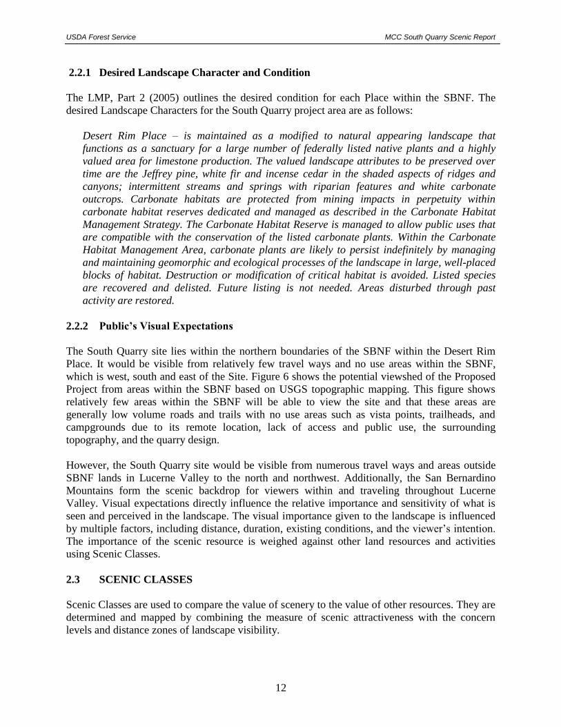
2.2.1 Desired Landscape Character and Condition
The LMP, Part 2 (2005) outlines the desired condition for each Place within the SBNF. The
desired Landscape Characters for the South Quarry project area are as follows:
Desert Rim Place – is maintained as a modified to natural appearing landscape that
functions as a sanctuary for a large number of federally listed native plants and a highly
valued area for limestone production. The valued landscape attributes to be preserved over
time are the Jeffrey pine, white fir and incense cedar in the shaded aspects of ridges and
canyons; intermittent streams and springs with riparian features and white carbonate
outcrops. Carbonate habitats are protected from mining impacts in perpetuity within
carbonate habitat reserves dedicated and managed as described in the Carbonate Habitat
Management Strategy. The Carbonate Habitat Reserve is managed to allow public uses that
are compatible with the conservation of the listed carbonate plants. Within the Carbonate
Habitat Management Area, carbonate plants are likely to persist indefinitely by managing
and maintaining geomorphic and ecological processes of the landscape in large, well-placed
blocks of habitat. Destruction or modification of critical habitat is avoided. Listed species
are recovered and delisted. Future listing is not needed. Areas disturbed through past
activity are restored.
2.2.2 Public’s Visual Expectations
The South Quarry site lies within the northern boundaries of the SBNF within the Desert Rim
Place. It would be visible from relatively few travel ways and no use areas within the SBNF,
which is west, south and east of the Site. Figure 6 shows the potential viewshed of the Proposed
Project from areas within the SBNF based on USGS topographic mapping. This figure shows
relatively few areas within the SBNF will be able to view the site and that these areas are
generally low volume roads and trails with no use areas such as vista points, trailheads, and
campgrounds due to its remote location, lack of access and public use, the surrounding
topography, and the quarry design.
However, the South Quarry site would be visible from numerous travel ways and areas outside
SBNF lands in Lucerne Valley to the north and northwest. Additionally, the San Bernardino
Mountains form the scenic backdrop for viewers within and traveling throughout Lucerne
Valley. Visual expectations directly influence the relative importance and sensitivity of what is
seen and perceived in the landscape. The visual importance given to the landscape is influenced
by multiple factors, including distance, duration, existing conditions, and the viewer’s intention.
The importance of the scenic resource is weighed against other land resources and activities
using Scenic Classes.
2.3 SCENIC CLASSES
Scenic Classes are used to compare the value of scenery to the value of other resources. They are
determined and mapped by combining the measure of scenic attractiveness with the concern
levels and distance zones of landscape visibility.

USDA Forest Service MCC South Quarry Scenic Report
13
Figure 6 Potential Viewshed of Proposed Project within SBNF Lands
USDA Forest Service MCC South Quarry Scenic Report
14
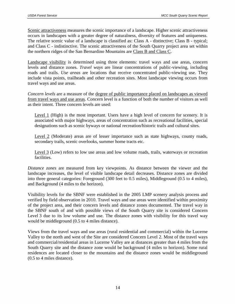
Scenic attractiveness measures the scenic importance of a landscape. Higher scenic attractiveness
occurs in landscapes with a greater degree of naturalness, diversity of features and uniqueness.
The relative scenic value of a landscape is classified as: Class A - distinctive; Class B - typical;
and Class C - indistinctive. The scenic attractiveness of the South Quarry project area set within
the northern ridges of the San Bernardino Mountains are Class B and Class C.
Landscape visibility is determined using three elements: travel ways and use areas, concern
levels and distance zones. Travel ways are linear concentrations of public-viewing, including
roads and trails. Use areas are locations that receive concentrated public-viewing use. They
include vista points, trailheads and other recreation sites. Most landscape viewing occurs from
travel ways and use areas.
Concern levels are a measure of the degree of public importance placed on landscapes as viewed
from travel ways and use areas. Concern level is a function of both the number of visitors as well
as their intent. Three concern levels are used:
Level 1 (High) is the most important. Users have a high level of concern for scenery. It is
associated with major highways, areas of concentration such as recreational facilities, special
designations such as scenic byways or national recreation/historic trails and cultural sites.
Level 2 (Moderate) areas are of lesser importance such as state highways, county roads,
secondary trails, scenic overlooks, summer home tracts etc.
Level 3 (Low) refers to low use areas and low volume roads, trails, waterways or recreation
facilities.
Distance zones are measured from key viewpoints. As distance between the viewer and the
landscape increases, the level of visible landscape detail decreases. Distance zones are divided
into three general categories: Foreground (300 feet to 0.5 miles), Middleground (0.5 to 4 miles),
and Background (4 miles to the horizon).
Visibility levels for the SBNF were established in the 2005 LMP scenery analysis process and
verified by field observation in 2010. Travel ways and use areas were identified within proximity
of the project area, and their concern levels and distance zones documented. The travel way in
the SBNF south of and with possible views of the South Quarry site is considered Concern
Level 3 due to its low volume and use. The distance zones with visibility for this travel way
would be middleground (0.5 to 4 miles distance).
Views from the travel ways and use areas (rural residential and commercial) within the Lucerne
Valley to the north and west of the Site are considered Concern Level 2. Most of the travel ways
and commercial/residential areas in Lucerne Valley are at distances greater than 4 miles from the
South Quarry site and the distance zone would be background (4 miles to horizon). Some rural
residences are located closer to the mountains and the distance zones would be middleground
(0.5 to 4 miles distance).
USDA Forest Service MCC South Quarry Scenic Report
15
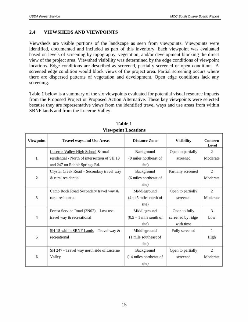
2.4 VIEWSHEDS AND VIEWPOINTS
Viewsheds are visible portions of the landscape as seen from viewpoints. Viewpoints were
identified, documented and included as part of this inventory. Each viewpoint was evaluated
based on levels of screening by topography, vegetation, and/or development blocking the direct
view of the project area. Viewshed visibility was determined by the edge conditions of viewpoint
locations. Edge conditions are described as screened, partially screened or open conditions. A
screened edge condition would block views of the project area. Partial screening occurs where
there are dispersed patterns of vegetation and development. Open edge conditions lack any
screening.
Table 1 below is a summary of the six viewpoints evaluated for potential visual resource impacts
from the Proposed Project or Proposed Action Alternative. These key viewpoints were selected
because they are representative views from the identified travel ways and use areas from within
SBNF lands and from the Lucerne Valley.
Table 1
Viewpoint Locations
Viewpoint
Travel ways and Use Areas
Distance Zone
Visibility
Concern
Level
1
Lucerne Valley High School & rural
residential - North of intersection of SH 18
and 247 on Rabbit Springs Rd.
Background
(9 miles northeast of
site)
Open to partially
screened
2
Moderate
2
Crystal Creek Road – Secondary travel way
& rural residential
Background
(6 miles northeast of
site)
Partially screened 2
Moderate
3
Camp Rock Road Secondary travel way &
rural residential
Middleground
(4 to 5 miles north of
site)
Open to partially
screened
2
Moderate
4
Forest Service Road (3N02) – Low use
travel way & recreational
Middleground
(0.5 – 1 mile south of
site)
Open to fully
screened by ridge
with time
3
Low
5
SH 18 within SBNF Lands – Travel way &
recreational
Middleground
(1 mile southeast of
site)
Fully screened 1
High
6
SH 247 - Travel way north side of Lucerne
Valley
Background
(14 miles northeast of
site)
Open to partially
screened
2
Moderate
USDA Forest Service MCC South Quarry Scenic Report
16
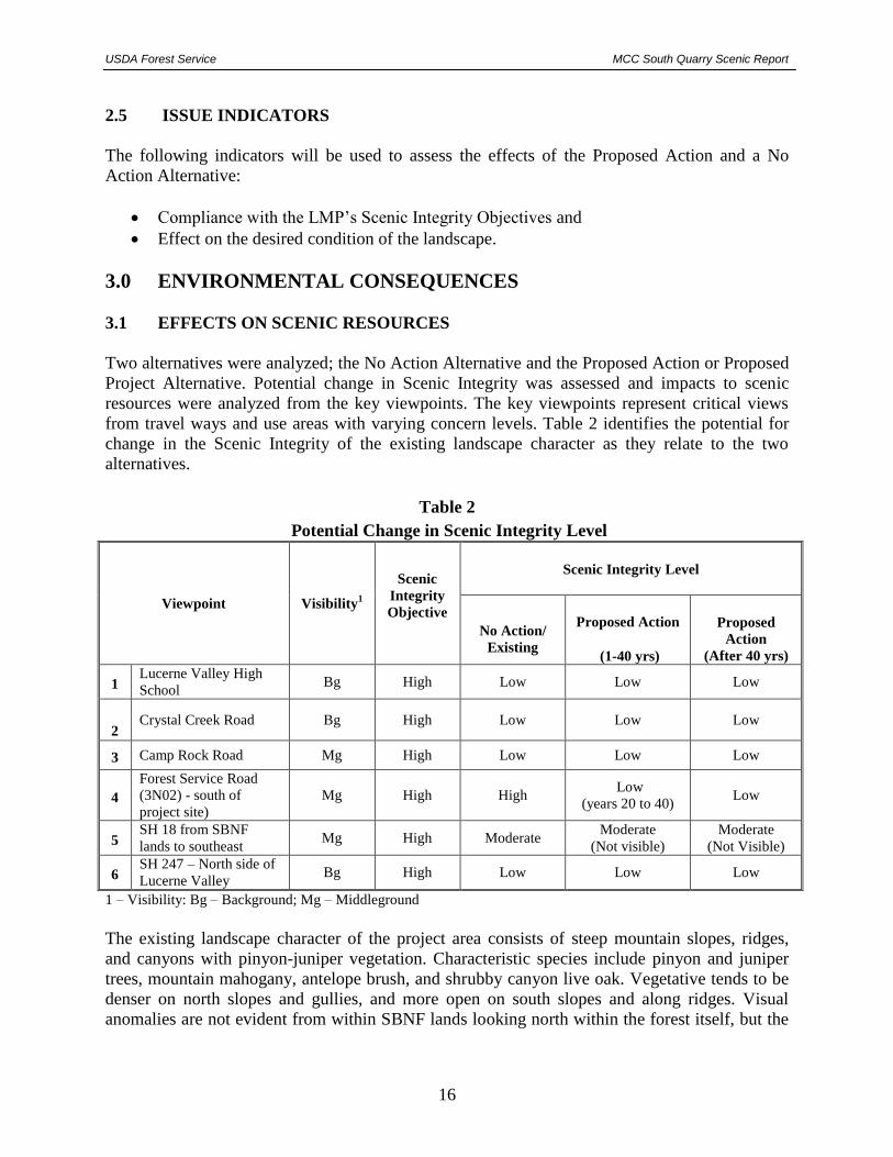
2.5 ISSUE INDICATORS
The following indicators will be used to assess the effects of the Proposed Action and a No
Action Alternative:
Compliance with the LMP’s Scenic Integrity Objectives and
Effect on the desired condition of the landscape.
3.0 ENVIRONMENTAL CONSEQUENCES 3.1 EFFECTS ON SCENIC RESOURCES
Two alternatives were analyzed; the No Action Alternative and the Proposed Action or Proposed
Project Alternative. Potential change in Scenic Integrity was assessed and impacts to scenic
resources were analyzed from the key viewpoints. The key viewpoints represent critical views
from travel ways and use areas with varying concern levels. Table 2 identifies the potential for
change in the Scenic Integrity of the existing landscape character as they relate to the two
alternatives.
Table 2
Potential Change in Scenic Integrity Level
Viewpoint
Visibility1
Scenic
Integrity
Objective
Scenic Integrity Level
No Action/
Existing
Proposed Action
(1-40 yrs)
Proposed
Action
(After 40 yrs)
1 Lucerne Valley High
School Bg High Low Low Low
2 Crystal Creek Road Bg High Low Low Low
3 Camp Rock Road Mg High Low Low Low
4
Forest Service Road
(3N02) - south of
project site)
Mg High High Low
(years 20 to 40) Low
5 SH 18 from SBNF
lands to southeast Mg High Moderate
Moderate
(Not visible)
Moderate
(Not Visible)
6 SH 247 – North side of
Lucerne Valley Bg High Low Low Low
1 – Visibility: Bg – Background; Mg – Middleground
The existing landscape character of the project area consists of steep mountain slopes, ridges,
and canyons with pinyon-juniper vegetation. Characteristic species include pinyon and juniper
trees, mountain mahogany, antelope brush, and shrubby canyon live oak. Vegetative tends to be
denser on north slopes and gullies, and more open on south slopes and along ridges. Visual
anomalies are not evident from within SBNF lands looking north within the forest itself, but the
USDA Forest Service MCC South Quarry Scenic Report
17
Lucerne Valley forms the background with its linear roads, scattered agriculture, and scattered
development.
Visual anomalies from the Lucerne Valley viewpoints looking generally southward include
existing mining roads, quarries, stockpiles, and mineral processing plants. For viewers relatively
close to the mining activities along the mountain slopes (Viewpoints 2 and 3), mining activities
become a dominant feature and corresponds to a Low scenic integrity. From viewers farther
north of the mountains, the mining activities are generally evident but not quite as dominant in
the landscape; though still considered as Low scenic integrity.
3.2 ALTERNATIVE A – NO ACTION
3.2.1 Direct and Indirect Effects
If the No Action Alternative is selected and the proposed South Quarry project does not take
place, there would be no direct effect to scenic resources within the SBNF and from the Lucerne
Valley. Under the No Project Alternative, mining would continue within the East and West Pits
at the rate of approximately 2.6 MTPY. Mining would be conducted at lower elevations to the
north of the SBNF boundary on private lands and BLM claims by MCC and others to the west of
the Proposed Site along the north slope of the San Bernardino Mountains. MCC would continue
mining within the existing East Pit for approximately 5 years and would continue developing the
West Pit per its 2004 County approved mine and reclamation plan. The West Pit will excavate a
ridge on the north slope directly west of the existing East Pit outside of SBNF lands. Note that
the “Cushenbury Mine Expansion EIR” (San Bernardino County & LSA 2004) determined that
visual impacts from the expansion of the West Pit would be potentially significant.
There would be no indirect effects to the future landscape character as viewed from SBNF lands
as the existing and approved future mining by MCC along the north slopes would be below the
northern ridgeline and would not be visible from SBNF lands.
There would be no indirect effects to the landscape character to views from Lucerne Valley if the
No Action Alternative is selected and the South Quarry is not developed. Under the No Project
Alternative, mining would continue within the East and West pits at the current approved rate of
2.6 MTPY.
3.2.2 Cumulative Effects
The No Action Alternative cumulative effects analysis for scenic resources include analysis
within the Desert Rim Place. The area of cumulative effects was bounded in this manner because
of the Place descriptions identified in the LMP. Cumulative effects include the past, existing, and
reasonably foreseeable future actions.
Existing and permitted mining on the north face of the San Bernardino Mountains has resulted in
surface disturbances that are visible from Lucerne Valley. Table 3 lists the existing mining
operations located in the region. Disturbances are evident on the mountain slopes due to the
generally light-color of the limestone quarries, stockpiles, and haul roads in contrast to
USDA Forest Service MCC South Quarry Scenic Report
18
undisturbed slopes. The top photograph of existing conditions in Figure 8A – 1A as seen from
Lucerne Valley High School shows the existing viewshed of the northern slopes and quarry
areas. The contrast between the natural landforms and the exposed mine features is the extent of
the landscape alteration. The limestone mines contribute to the impact due to color contrast
between mined and unmined areas and due to their position on the mountain slopes (centrally
located between the valley floor and the ridge line), whereas aggregate mines occur at a lower
elevation and generally have a much less color contrast and therefore, appear less visible to the
surrounding area.
Table 3
Existing and Foreseeable Actions
and Effects on Cumulative Scenic Integrity
Project Location Description Status
Cumulative
Effects on
Scenic Integrity
Specialty
Minerals, Inc.
West of Marble Canyon, east
of Furnace Creek. Quarries and
haul roads on north-facing
slopes.
Several limestone
quarries, stockpiles,
haul roads, and
processing plant
Active Increase
OMYA California,
Inc.
Southern terminus of Crystal
Creek Rd, approx. 7 miles west
of project. Quarry and haul
roads on north-facing slopes.
Two limestone
quarries, stockpiles,
haul roads, and
processing plant
Active Increase
Cushenbury Sand
and Gravel Quarry
1.5 miles north of the project
site, west of the junction of
SR18 and Camp Rock Rd at
lower elevation on alluvial fan
Sand and gravel mine
and processing plant Active Unchanged
Crystal Hills Sand
and Gravel, Inc.
South of Meridian Rd adjacent
to rail line, approx. 5 miles
northwest of the project site at
lower elevation on alluvial fan.
Sand and Gravel
Mine Inactive Unchanged
Hi-Grade
Materials
7 miles northwest of the
project, along Meridian Rd at
Azurite Rd at lower elevation
on alluvial fan.
Sand and gravel mine
and processing plant Active Unchanged
Mitsubishi Cement
Corporation
North and at lower elevation
than the Proposed Project.
Quarries and access roads on
north-facing slopes.
Existing East Pit,
developing West Pit,
proposed South
Quarry, cement plant
and haul roads
Active Increase
Note that Omya’s Sentinel Quarry and Butterfield Quarry are within the SBNF and these quarries are
not visible from Lucerne Valley. The remaining limestone quarries are on private land or BLM
unpatented claims on the north-facing slopes visible from Lucerne Valley. The sand and gravel mines
are located on the alluvial fans north of the visible north-facing slopes and are generally much less
visible due to their lower elevations.
USDA Forest Service MCC South Quarry Scenic Report
19
Most of the mining operations along the north face of the San Bernardino Mountains are active
and permitted for many decades into the future. Concurrent reclamation upon completion of
benches or phases of mining in the form of revegetation, covering of exposed areas with darker
material, erosion control, and rock staining is required of most mining operations. Final
reclamation would not commence until a specific operation or phase is completed.
There would be no cumulative effects to the future landscape character of the Desert Rim as
viewed from SBNF lands and from Lucerne Valley for the No Action Alternative. The existing
and approved future mining by MCC and other mine companies along the north slopes would
generally be outside or north of SBNF lands below the northern ridgeline and would not be
visible from SBNF lands. If the No Action Alternative is selected, cumulative effects are
expected to increase over time with the approved mining activities and then gradually decrease
with implementation of reclamation; the additional South Quarry areas would not be disturbed
and would not add to cumulative impacts (see Figure 7).
3.2.3 Conclusion
If the No Action Alternative is selected and the proposed South Quarry project does not take
place, there would be no direct or indirect effects to scenic resources as viewed from within the
SBNF and from Lucerne Valley. The existing and approved future mining by MCC along the
north slopes would be below the northern ridgeline and would not be visible from SBNF lands;
however, the existing and approved mining would be visible from Lucerne Valley The visual
impact would remain unchanged and the overall Scenic Integrity from Lucerne Valley would
still be considered Low.
3.3 ALTERNATIVE B – PROPOSED PROJECT
As discussed in Section 1.1 above, MCC is proposing to develop and reclaim a new high grade
limestone quarry to the south of its East Pit (existing), West Pit (under development), and the
Cushenbury Cement Plant. The South Quarry and haul road will be located almost entirely
(147 acres) on public federal land under the jurisdiction of the SBNF with approximately
6.6 acres of the haul road located on MCC fee land where haul road enters the existing East Pit.
For a detailed description of the Proposed Action, please refer to the “Plan of Operations and
Reclamation Plan for Mitsubishi Cement Corporation’s South Quarry” (MCC July 2011)
submitted to the SBNF.
This higher grade limestone will be blended with lower grade limestone excavated from the West
and East Pits at a ratio of approximately 50/50 in order to meet the limestone specifications to
feed the adjacent Cushenbury Cement Plant. The South Quarry will be mined at an average
production rate of 1.3 MTPY of ore for up to 120 years. At this time, MCC is requesting a
120-year operations plan (through the year 2131) excavating approximately 156 MT of ore. The
overall limestone production of 2.6 MTPY and 300,000 tons of waste rock at the mining
complex will not change from the approved production.

USDA Forest Service MCC South Quarry Scenic Report
20
FIGURE 7 (NEW) Alternative A - No Project

USDA Forest Service MCC South Quarry Scenic Report
21
Limestone ore excavated at the South Quarry will be hauled by off-road haul trucks to the
existing primary crusher located at the north end of the existing East Pit. During the first two
years, the 1.8-mile long haul road will be constructed. The planned haul road will access the
South Quarry at 5,950 feet amsl and traverse down the north slope to an elevation of 5,050 feet
amsl at the southwest corner of the existing East Pit. The road’s surface width will be 50 to
60 feet with a grade not to exceed 10%. The road will be designed primarily as cut (not fill) so as
to limit the visual impacts associated with unvegetated fills as seen on other haul roads in the
area. The estimated disturbance area of the proposed haul road is 22.2 acres of which 6.6 acres is
on MCC fee land and 15.6 acres on SBFS land.
Specific reclamation activities will occur concurrent with excavations and throughout the life of
the operations such as slope reduction, stockpile management, erosion control, and revegetation.
At the conclusion of excavations, 5 years of active reclamation and revegetation will be
implemented followed by revegetation monitoring and remediation until revegetation goals are
achieved. Unlike other limestone mines in the area, waste rock will be deposited within the
quarry itself to fill or reduce slopes in Phases 1B, 2, and 3 and will not create any waste rock
stockpiles outside the quarry. This will limit impacted areas to the quarry and haul road and
eliminate potential visual, stability, and erosion impacts of a typical waste rock stockpiles.
3.3.1 Quarry Phasing
The excavation plan for the South Quarry is divided into four phases based on operational,
engineering, and environmental concerns. Table 4 lists the pertinent data per mining phase
including the expected years of operation based on average production rates, size, ore reserves,
and waste rock. The South Quarry is proposed to be excavated according to this phasing plan.
However, mining operations will experience unscheduled interruptions and/or phasing changes
due to various market/economic demands and variation in slopes and material quality beyond
MCC’s control since the natural deposit is not of uniform quality. It may be necessary, therefore,
to excavate selectively from different locations within the quarry to achieve a suitable blend of
raw materials. The SBNF and the County of San Bernardino will be updated in the annual
monitoring report on the status of operational phases.
The following is a summary of the planned mining operations by phase.
Phase 1A
Phase 1A will be initiated after construction of the haul road and compliance with pre-
construction conditions. Approximately 500,000 tons of waste rock or less will be produced
which will be used for the southern berm and stored in stockpiles within the Phase 1B quarry
area. Based on the bore hole data, minimal waste rock is expected in this area. Off–road haul
trucks will transport material down the new haul road to the existing primary crusher located at
the north end of the existing East Pit near the cement plant. This phase is essentially an extension
of the haul road of which approximately 1,600 feet will be excavated up to 300 feet deep into the
quarry area as the quarry is excavated. The phase and extended haul road were designed in this
way in order to depress this portion of the haul road below the remaining cut on its north facing
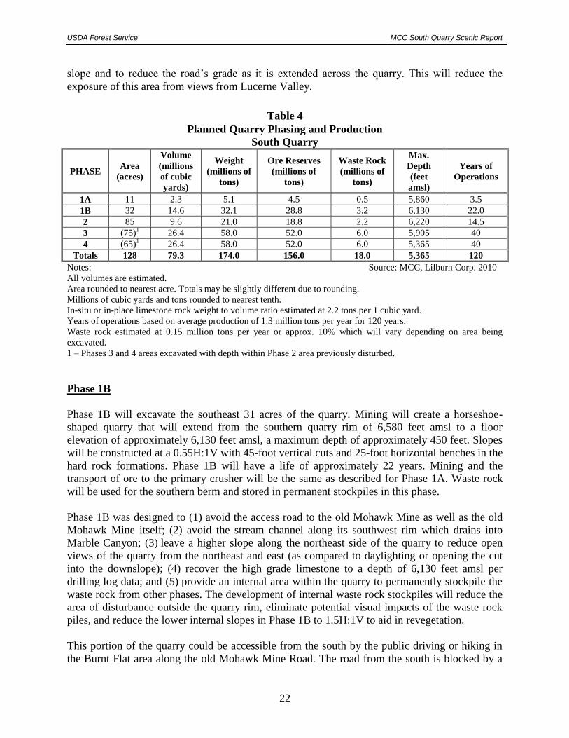
USDA Forest Service MCC South Quarry Scenic Report
22
slope and to reduce the road’s grade as it is extended across the quarry. This will reduce the
exposure of this area from views from Lucerne Valley.
Table 4
Planned Quarry Phasing and Production
South Quarry
PHASE Area
(acres)
Volume
(millions
of cubic
yards)
Weight
(millions of
tons)
Ore Reserves
(millions of
tons)
Waste Rock
(millions of
tons)
Max.
Depth
(feet
amsl)
Years of
Operations
1A 11 2.3 5.1 4.5 0.5 5,860 3.5
1B 32 14.6 32.1 28.8 3.2 6,130 22.0
2 85 9.6 21.0 18.8 2.2 6,220 14.5
3 (75)1
26.4 58.0 52.0 6.0 5,905 40
4 (65)1
26.4 58.0 52.0 6.0 5,365 40
Totals 128 79.3 174.0 156.0 18.0 5,365 120
Notes: Source: MCC, Lilburn Corp. 2010
All volumes are estimated.
Area rounded to nearest acre. Totals may be slightly different due to rounding.
Millions of cubic yards and tons rounded to nearest tenth.
In-situ or in-place limestone rock weight to volume ratio estimated at 2.2 tons per 1 cubic yard.
Years of operations based on average production of 1.3 million tons per year for 120 years.
Waste rock estimated at 0.15 million tons per year or approx. 10% which will vary depending on area being
excavated.
1 – Phases 3 and 4 areas excavated with depth within Phase 2 area previously disturbed.
Phase 1B
Phase 1B will excavate the southeast 31 acres of the quarry. Mining will create a horseshoe-
shaped quarry that will extend from the southern quarry rim of 6,580 feet amsl to a floor
elevation of approximately 6,130 feet amsl, a maximum depth of approximately 450 feet. Slopes
will be constructed at a 0.55H:1V with 45-foot vertical cuts and 25-foot horizontal benches in the
hard rock formations. Phase 1B will have a life of approximately 22 years. Mining and the
transport of ore to the primary crusher will be the same as described for Phase 1A. Waste rock
will be used for the southern berm and stored in permanent stockpiles in this phase.
Phase 1B was designed to (1) avoid the access road to the old Mohawk Mine as well as the old
Mohawk Mine itself; (2) avoid the stream channel along its southwest rim which drains into
Marble Canyon; (3) leave a higher slope along the northeast side of the quarry to reduce open
views of the quarry from the northeast and east (as compared to daylighting or opening the cut
into the downslope); (4) recover the high grade limestone to a depth of 6,130 feet amsl per
drilling log data; and (5) provide an internal area within the quarry to permanently stockpile the
waste rock from other phases. The development of internal waste rock stockpiles will reduce the
area of disturbance outside the quarry rim, eliminate potential visual impacts of the waste rock
piles, and reduce the lower internal slopes in Phase 1B to 1.5H:1V to aid in revegetation.
This portion of the quarry could be accessible from the south by the public driving or hiking in
the Burnt Flat area along the old Mohawk Mine Road. The road from the south is blocked by a
USDA Forest Service MCC South Quarry Scenic Report
23
permanently locked SBNF gate approximately 0.25 miles south of the site and the road is not
maintained north of the gate. To further reduce the accessibility of the quarry, MCC is planning
on constructing a landscape and safety berm along the southern rim for a distance of
approximately 2,330 feet. This berm will tie into steeper slopes on the east and the southwest to
restrict access. The berm will be composed of waste rock and salvaged soil approximately 6 feet
in height with 2H:1V slopes and will cover approximately 2.7 acres with the adjacent set back
and access road. The berm will include placement of a mixture of large rocks to discourage
riding over it, warning signs, and revegetated with native vegetation.
Phase 2
Phase 2 will excavate the central 85 acres of the quarry. Mining during this phase will essentially
level the quarry and create an oval shaped quarry. The quarry depth will extend from Phase 1B
with an average base elevation of 6,220 feet amsl. Slopes will be constructed at a 0.55H:1V with
45-foot vertical cuts and 25-foot horizontal benches in the hard rock formations. Phase 2 will
have a life of approximately 14.5 years, for a cumulative total of 40 years from commencement
of mining.
Phase 3
Phase 3 will be a 40-year excavation phase on approximately 75 acres within the central part of
the quarry within the footprint of Phase 2. Mining will excavate to floor elevation of
approximately 5,905 feet amsl, a depth of approximately 315 feet amsl below the Phase 2 floor
elevation of 6,130 feet amsl. Slopes will be constructed at a 0.55H:1V with 45-foot vertical cuts
and 25-foot horizontal benches in the hard rock formations. Mining and the transport of ore to
the primary crusher will be the same as described above. Approximately 6 MT of waste rock will
be produced in Phase 3 which will be stored in the permanent stockpiles in Phase 1B.
Phase 3 was designed to maximize the recovery of the limestone resource with depth while
staying within the planned 128–acre perimeter and leave the outside slope on the northeast side
of the quarry to reduce open views of the quarry (as compared to daylighting the cut into the
downslope).
Phase 4
Phase 4 will be the final excavation phase on approximately 65 acres within the central part of
the proposed South Quarry configuration for the 120-year lifespan. Mining will excavate to a
floor elevation of approximately 5,365 feet amsl, a maximum depth of approximately 550 feet
amsl below the Phase 3 floor elevation of 5,905 feet amsl. Slopes will be constructed at a
0.55H:1V with 45-foot vertical cuts and 25-foot horizontal benches in the hard rock formations.
Mining and the transport of ore to the primary crusher will be the same as described above.
Approximately 6 MT of waste rock will be produced in Phase 4 which will be stored in the
permanent stockpiles on the southeast side of Phase 4.

USDA Forest Service MCC South Quarry Scenic Report
24
Reclamation Plan
The Reclamation Plan discussed in detail in Section 2 of the South Quarry Plan of Operations
and Reclamation Plan proposes to reclaim the quarry site to meet both Forest Service Minerals
Regulations (36 CFR 228, Subpart A) under the jurisdiction of the SBNF and SMARA
implemented by the County that will minimize impacts to the surrounding environment. The
objectives of this Reclamation Plan are to:
Eliminate or reduce environmental impacts from mining operations including control of
erosion, water runoff, and landslides;
Reclaim in a usable condition for post-mining end uses which will include open
space/habitat;
Reshape mining features and revegetate disturbed areas to minimize biological and
hydrological impacts; and
Reclaim the site as necessary to eliminate hazards to public health and safety.
The permanent perimeter quarry slopes will be reclaimed from the rim downward as completed
per phase to meet designed slopes dependent on the findings of the ongoing slope stability
assessments. Reclamation will consist of sloping excavated cuts and benches as necessary to
meet the designed 0.55H:1V overall slope and to round the rims of the final benches. Each bench
will be sloped inward toward the vertical wall to capture any precipitation or runoff. The
individual benches will be approximately 45 feet vertical and 25 feet wide unless required to be
flatter in specific areas, as determined by geological mapping during ongoing quarry operations
or where the waste rock stockpiles will be located. The top four benches on the south and
southeast side of the quarry from the rim to approximately 180 feet in height may be visible from
Lucerne Valley. These benches will be sculptured (roughened) and the benches rounded to
reduce straight lines and visual impacts. In addition, at approximately every 500 feet, a ramp will
be constructed to connect the benches to allow for wildlife movement within the reclaimed
quarry.
Surface material salvaged for revegetation will be limited due to the surficial rock conditions on-
site. Available material containing the native seed bank will be placed on the benches and will be
augmented with additional growth media and mulch in “islands” to provide future sources of
seeds. The revegetation methods include seeding with native perennial species, plantings grown
in a nursery whether started from seed, cuttings or whole plant salvage from seeds collected at or
near the site, and planting plants salvaged from new mining areas.
3.3.2 Direct and Indirect Effects
Six viewpoints were selected for visual analysis of the Proposed Action and photo simulations
were prepared to show potential visual views of the site from key viewpoint areas; two
viewpoints from the south in SBNF lands and four viewpoints from the north in Lucerne Valley
(see Figure 8). Tables 1 and 2 previously described these viewpoints.

USDA Forest Service MCC South Quarry Scenic Report
25
Figure 8 VIEWPOINT LOCATIONS
USDA Forest Service MCC South Quarry Scenic Report
26
Visual simulations from four viewpoints within Lucerne Valley and two from SBNF lands were
prepared to show representational changes in the landscape caused by the proposed excavations.
Viewpoints 1, 2, and 3 in Lucerne Valley include the existing conditions photographs and
simulations of the quarry development at 10 and 25 -year intervals during Phases 1 and 2; at the
end of Phase 2 in 40 years; at the end of Phase 3 in 80 years, and at the end of mining in Phase 4
at 120 years with final reclamation. The simulations include concurrent reclamation and
revegetation over the years.
The simulations for every phase at Viewpoints 4, 5, and 6 were not prepared as there may be no
discernable change over time or the phase is not visible. The West Pit now under development is
shown at buildout by year 40 with concurrent reclamation for the simulations to show a worst
case view in this area; however, mines operated by the other operators west of the Proposed
Project site are not shown as expanding over time due to the unknown time frame and plans for
these other quarries.
When compared against the existing natural landscape character, the Proposed Action would
create a contrast in color and also in form and line. Color contrast would occasionally be less in
the winter due to snow in the higher elevations. The color difference from the newly exposed
limestone rock and the existing darker landform is the main contrasting element from
background and middleground views, varying over time in intensity due to atmospheric
conditions, natural weathering, shadowing, clouds, and snowfall. The changing topography
within the mine excavation area would also create angles, as compared to the natural landform of
the Desert Rim Place and the north slope of the San Bernardino Mountains. This would be more
notable in middleground and foreground views looking south from Lucerne Valley (Viewpoints
1, 2, and 3) and only temporarily from Viewpoint 4 in the SBNF looking north. The South
Quarry site would be seen from all viewpoints except for Viewpoint 5, from which the proposed
South Quarry is not visible during all phases.
Impacts from the various viewpoint locations are summarized in Table 2 above. During Phases
1A, 1B, and 2 (to approximately year 40), the majority of visual impacts would be from
construction of the haul road along the north slope and the initiation of mining along the upper
quarry slopes in the southeast portion of the site near the ridgeline. The haul road would create
cut lines that run across the north slope face and both the quarry and haul road would be readily
seen from foreground and middleground views from Lucerne Valley. The quarry benching
would create an element that deviates from the form, line, and texture of the natural appearing
landscape. With concurrent reclamation and revegetation, and natural weathering, the lighter
color of newly cut slopes would darken over time.
During Phases 3 and 4 (approximately years 40 through 120), excavations would deepen the
quarry and remove a portion of the north facing slope, exposing a larger area as viewed from
Lucerne Valley. The excavations during these two phases would be seen from the Lucerne
Valley viewpoints as a contrasting lighter area along the mountain slope. However, by this
timeframe, it is expected that reclamation and revegetation of the upper slopes in Phase 2 (see
Section 4 – Mitigation below) would begin to darken the cut slopes reducing the color contrast
and visibility of the upper slopes. The excavations during these two phases would not be seen
USDA Forest Service MCC South Quarry Scenic Report
27
from Viewpoint 4 along SBNF Road 3N02 as excavations would be blocked from view by an
intervening ridge.
Unlike other limestone mines in the area, waste rock (rock not suitable for cement production)
will be deposited within the quarry itself to fill or reduce slopes in Phases 1B, 2, and 3 and will
not create any waste rock stockpiles outside the quarry. This will limit impacted areas to the
quarry and haul road and eliminate potential visual impacts of typical waste rock stockpiles
located outside the quarry footprint.
Mining operation haul trucks and equipment generally have higher contrast in form, line, texture,
and color because of the increased reflectivity, brighter colors, and angled features compared to
the natural dark grey landscape sloping landform. The scale and screening of these contrasting
features make them primarily visible only in the foreground views. Operation plans will leave in-
place a 20 to 25-foot high natural perimeter berm or slope (half a vertical bench height) on the
outside ridge of each excavated bench until the interior area of the next lower excavation level is
completed to screen mining equipment.
The visual assessment from each viewpoint is summarized below including the figures with the
existing photographs and simulations. The Viewpoint Inventory and Analysis Summary
worksheets are include in Appendix A.
Viewpoint 1 - Lucerne Valley High School
(Please refer to Figures 9A, 9B, and 9C). The South Quarry site is located approximately 9 miles
southeast and just below the ridgeline of the scenic backdrop as viewed looking southeast from
the Lucerne Valley High School east of SR 247 and north of SR 18 on Rabbit Springs Road. The
viewshed is described as open. The existing scenic integrity for the area is considered Low due
to the existing man-made structures and alterations along the slopes. Figure 9A – Simulation 2
during Phase 1A in approximately 10 years shows the faint line of the haul road and the initiation
of one or two quarry benches on the upper ridge. Figure 9B–3 at approximately 25 years shows
on the left side of the illustration, the upper quarry as a lighter contrast due to exposed limestone
slopes. Figure 9B-4 shows the quarry at the end of Phase 2 in approximately 40 years. The
exposed slope areas have been darkened slightly due to reclamation and have not changed in size
from 25 years as additional mining is extending downward below an intervening ridgeline. The
simulation for the end of Phase 3 (Figure 9C-5) at approximately year 80, shows the exposure of
the back quarry wall as mining removes a portion of the front slope. The last simulation on
Figure 9C-6 shows the South Quarry site at the end of mining with reclamation and revegetation
decreasing the contrast of the site. The scenic integrity of the view would remain Low since
previous mining operations adjacent to the South Quarry site have created an altered or Low
scenic integrity for the area. The Proposed Project, while incrementally adding to the
disturbances on the north slopes, would not substantially decrease the scenic integrity.

USDA Forest Service MCC South Quarry Scenic Report
28
Figure 9A VIEWPOINT 1 - Existing, 10 yrs,

USDA Forest Service MCC South Quarry Scenic Report
29
Figure 9B – 25 yrs and 40 yrs.

USDA Forest Service MCC South Quarry Scenic Report
30
Figure 9C – 80 and 120 yrs
USDA Forest Service MCC South Quarry Scenic Report
31
Viewpoint 2 – Crystal Creek Road
(Please refer to Figures 10A, 10B, and 10C). The South Quarry site is located approximately
6.5 miles southeast and near the ridgeline as viewed looking southeast from near the intersection
of Crystal Creek and Azurite roads. The South Quarry site is visible and is only partially
screened by foreground vegetation. The existing scenic integrity is considered Low due to the
dominant deviation and altered landscape of the existing mines, stockpiles, and haul roads to the
right or west of the Proposed Project as viewed towards the south and southeast. As can be seen
on the left side of the illustration in Figure 10A – Simulation 2 for Phase 1 in approximately
10 years, the upper quarry benches are becoming visible as mining is initiated. In Figure 10B–3
in approximately 25 years, the upper slopes have expanded downward showing a lighter contrast
due to exposed limestone to a point where an intervening ridge hides the lower quarry slopes.
Figure 10B-3 during Phase 2 in approximately 40 years, shows no substantial change to the area
impacted the upper quarry with slightly darker coloring due to revegetation and weathering.
Simulations for the next two phases (approximately years 80 and 120) in Figures 10C-5 & 6,
show the exposure of the mining down the front slope. The last simulation on Figure 10C-6
shows the site with revegetation decreasing the contrast of the site. Given the closer distance and
presence of the existing mine activities below and to the west of the South Quarry operations
within the Middle and Background viewsheds, the scenic integrity for the area would not
substantially decrease and would remain Low under the Proposed Project.
Viewpoint 3 – Camp Rock Road
(Please refer to Figures 11A, 11B, and 11C).The South Quarry site is located below the ridgeline
of the scenic backdrop as viewed from 5 miles north, just west of Camp Rock Road at Arroyo
Road. The viewshed is described as open. The existing scenic integrity for the area is considered
Low due to the altered north slope landscape of the existing mines, stockpiles, process plants,
and haul roads. Figure 11A – Simulation 2 for Phase 1 at approximately 10 years depicts a line
representing the initiation of mining on the upper slopes. Figures 11B–3 and 4 at approximately
25 and 40 years show the upper quarry as a lighter contrast due to exposed limestone slopes. The
exposed slope areas have been darkened slightly due to reclamation and have not changed in size
as additional mining is extending downward below the intervening front ridgeline left in-place.
The access road is not expected to be as visible as other haul roads to the west as the road is
designed to be mostly cut into the hill rather than filling lower areas with lighter colored fill or
allowing the fill to roll downhill. In addition, the West Pit is simulated to the right and lower than
the Proposed Project. This pit is expected to be greyer due to the type of limestone excavated in
this area. The West Pit was approved in 2004 and is under development. It is not a part of the
South Quarry Project. It is shown in the visual simulations for completeness.
Simulations for the next two phases (approximate years 80 and 120) in Figures 11C-5 and 6,
show the exposure of the mining down the front slope. The last simulation on Figure 11C shows
the site after mining in approximately 120 years with revegetation decreasing the contrast of the
site. Due to the presence of the existing mine activities and the development of the approved
West Pit to the west of the Proposed Project site, the scenic integrity for the area would not
substantially decrease and would remain Low under the Proposed Project.

USDA Forest Service MCC South Quarry Scenic Report
32
Figure 10A
Viewpoint 2 – Existing and 10 yrs.

USDA Forest Service MCC South Quarry Scenic Report
33
Figure 10B VP 2 25 and 40 years

USDA Forest Service MCC South Quarry Scenic Report
34
Figure 10C
VP 2 80 and 120 years

USDA Forest Service MCC South Quarry Scenic Report
35
Figure 11A VP3

USDA Forest Service MCC South Quarry Scenic Report
36
Figure 11B VP3

USDA Forest Service MCC South Quarry Scenic Report
37
Figure 11C VP3
USDA Forest Service MCC South Quarry Scenic Report
38
Viewpoint 4 - Forest Service Road 3N02
(Please refer to Figure 12). Viewpoint 4 is located approximately 1.5 miles south of the project
site along SBNF Road 3N02, a rugged dirt road with low use within the SBNF. The viewshed
along 3N02 is often obscured by pine and oak trees and surrounding ridges. The viewpoint
selected is in an opening along the road looking north. The existing scenic integrity for the area
is considered High for the forest lands decreasing to Moderate as views of Lucerne Valley
become dominant in the background beyond the ridgeline (see Figure 12 – 1).
The South Quarry site is located beyond the second ridgeline as viewed north towards Lucerne
Valley. The Proposed Project would remove the third or last ridgeline of more scattered
vegetation during Phase 2 in the approximate 20 to 40 year time frame from project start. During
this time, active mining would be visible and the scenic integrity would be considered Low.
Thereafter, the ridge would be removed and mining would no longer be visible as the quarry and
mining become blocked by the intervening ridgeline (see Figure 12–2). Thereafter, the scenic
integrity would again be considered High as no altered landscape would be visible in the
foreground or middleground from this particular viewpoint. However, the South Quarry would
still be considered to have a Scenic Integrity of Low and would not be consistent with the area’s
SIO of High.
Viewpoint 5 - SR 18 from Forest Service Lands
(Please refer to Figure 13). This viewpoint is located about 1 mile southeast of the South Quarry
site along SR 18 near Cactus Flats. This viewpoint shows the ridgeline just above the eastern
portion of the Proposed Project in the vicinity of the Old Mohawk Mine. Due to the steep ridges
in this area, there are no views of the Proposed Project during the life of the Proposed Project.
The existing scenic integrity for the area (Moderate due to existing road impacts) would remain
unchanged by the Proposed Project.
Viewpoint 6 - SR 247 from Northern Lucerne Valley
(Please refer to Figure 14). The South Quarry site is located approximately 14 miles south just
below the ridgeline of the scenic backdrop as viewed from SR 247 from the northern edge of
Lucerne Valley. The viewshed is of a desert valley with a background of the San Bernardino
Mountains. The existing scenic integrity for the area is considered Moderate with the road and
existing mining areas along the mountain slopes slightly altering the viewshed.
The Proposed Project would slightly increase the mining areas visible at this distance. Given the
distance to the site and the natural air turbidity (dust and moisture), even on a clear day, no
distinct or dominant mine forms would be visible. (Note that due to this distance, only the final
project phase is simulated and this is shown as a small area lighter in color along the slopes.
Deviations will exist but will be subordinate to the overall landscape being reviewed.) The scenic
integrity from this distance would remain unchanged (Low) since the roadway and previous
mining operations adjacent to and west of the South Quarry site have created a slightly altered or
Low scenic integrity for the area.

USDA Forest Service MCC South Quarry Scenic Report
39
Figure 12 VP 4 SBNF Road

USDA Forest Service MCC South Quarry Scenic Report
40
Figure 13 SR 18

USDA Forest Service MCC South Quarry Scenic Report
41
Figure 14 North side of Lucerne Valley
USDA Forest Service MCC South Quarry Scenic Report
42
Indirect Effects
Implementation of the MDAQMD rules and regulations will minimize the creation of visible
dust from the mining operation. The distance from the sensitive viewing areas would further
reduce the likelihood of visual impacts from dust. Dust control measures will include water
spraying of haul roads, active mining areas, and waste rock stockpiles. In addition, compliance
with MDAQMD Rules 401 (limiting visible emissions from exhaust); 402 (avoid nuisance
emissions to people or businesses or property); 403 prohibits visible dust from crossing property
lines); and 403.2 (requirements for controlling fugitive dust) will be implemented as applicable.
Therefore the Proposed Project would have negligible effects to scenic resources from dust.
3.3.3 Cumulative Effects
Existing and permitted mining on the north face of the San Bernardino Mountains has resulted in
surface disturbances that are visible from Lucerne Valley (refer to Table 3). Disturbances are
evident on the mountain slopes due to the generally light-color of the limestone quarries,
stockpiles, and haul roads in contrast to undisturbed slopes. Figure 7 as seen from Lucerne
Valley High School shows the existing viewshed of the northern slopes and quarry areas. The
contrast between the natural landforms and the exposed mine features is the extent of the
landscape alternation. The limestone mines contribute to the impact due to color and contrast in
form, line, and texture between mined and unmined areas and due to their position on the
mountain slopes (centrally located between the valley floor and the ridge line). The three local
aggregate mines occur at lower elevations and generally have less color contrast; and therefore
they are not as visible from the Valley.
Most of the mining operations along the north face of the San Bernardino Mountains are active
and are permitted for many decades. Concurrent reclamation in the form of revegetation,
covering of exposed areas with darker material, erosion control, and rock staining is required of
most mining operations as a specific phase or area is completed.
The Proposed Project would not substantially change the Scenic Integrity of the area as discussed
under each viewpoint above however it would incrementally add to the existing visual impacts.
Potential changes to the area’s visual characteristics by implementation of the Proposed Project
are demonstrated together with other existing mining activities in Figure 9A–3 in approximately
25 years. The Proposed Project and continued excavation at adjacent mine sites would add to
cumulative visual effects along the north side of the San Bernardino Mountains as viewed from
Lucerne Valley.
The Proposed Project is not expected to cause cumulative effects to the future landscape
character of the Desert Rim as viewed from SBNF lands. The existing and approved future
mining by MCC and other mine companies along the north slopes would generally be outside or
north of SBNF lands below the northern ridgeline and would not be visible from SBNF lands. If
the Proposed Project is selected, cumulative effects are expected to remain unchanged as the
additional South Quarry site would only be visible temporarily from Viewpoint 4 and would not
be visible from SR 18 in the SBNF lands (refer to Figure 12-2 to see the Proposed Project impact
from Viewpoint 4).
USDA Forest Service MCC South Quarry Scenic Report
43
3.3.4 Conclusion
As included under Section 2.2.1 above, the LMP, Part 2 (2005) outlines the desired Landscape
Character for the Proposed Project as follows:
Desert Rim Place – is maintained as a modified to natural appearing landscape that
functions as a sanctuary for a large number of federally listed native plants and a highly
valued area for limestone production.
The LMP defines Aesthetic Management Standards as follows:
S9: Design management activities to meet the Scenic Integrity Objectives (SIO)
shown on the Scenic Integrity Objectives Map (see Figure 4).
S10: Scenic Integrity Objectives will be met with the following exceptions:
Minor adjustments, not to exceed a drop of one SIO level, are allowable with the
Forest Supervisor’s approval. Temporary drops of more than one SIO level may
be made during and immediately following project implementation providing they
do not exceed three years in duration.
The Proposed Project would decrease the High scenic integrity from views within the SBNF
along Road 3N02 to Low as the quarry is excavated. After approximately year 40, the mined
ridge would be removed and mining would no longer be visible as the quarry and mining become
blocked by the intervening ridgeline. The scenic integrity would again be considered High as no
altered landscape would be visible in the foreground or middleground from this particular
viewpoint. However, the South Quarry would still be considered to have a scenic integrity of
Low and would not be consistent with the area’s SIO of High.
Viewers from SR 18 within the SBNF to the southeast would not be able to see the Proposed
Project due to intervening ridges and the scenic integrity would remain unchanged.
The scenic integrity from the four (4) viewpoints within Lucerne Valley would incrementally
decrease; however, the overall scenic integrity for each viewpoint would not change remaining at
Low levels for all views meeting the S9 standard above.
There would also be no indirect effects to the future landscape character as viewed from SBNF
lands or from the Lucerne Valley with implementation of the MDAQMD rules and regulations
that will minimize the creation of visible dust from the mining operation.
The Proposed Project would incrementally increase cumulative impacts from views in Lucerne
Valley. When considered with other existing mining activities along the north face of the San
Bernardino Mountains, the cumulative scenic integrity would not substantially change and would
remain at Low to Moderate levels.

USDA Forest Service MCC South Quarry Scenic Report
44
4.0 MITIGATION
The following Project Design features have been incorporated into the Proposed South Quarry
Plan of Operations and the Reclamation Plan by MCC:
Design haul road with minimal fill slopes to reduce the contrast of the lighter-colored fill
on the natural slopes and boulder roll-down;
Utilize approved color-staining product to darken the access road cuts and visible
southern quarry slopes where shown to be successful;
Design adequate erosion control features along the haul road to limit erosion downslope;
Construct haul road in Phase 1A to be below the north facing slope to block road views;
Paint any onsite structures a color with low contrast and reflectivity;
Construct a landscaped berm along the south rim;
Design footprint of quarry to avoid any streams and riparian habitat;
Limit surface disturbances to areas identified in the Mine Reclamation Plan. Disturbances
outside these areas shall be prohibited;
Design quarry to limit any views of quarry site from east and southeast;
Cut or roughen upper slopes that may be visible from Lucerne Valley to reduce straight
lines and visual impacts as benches completed;
Design quarry to limit views of the lower half of quarry by not removing north slope
through approximately year 80 allowing decades of reclamation and revegetation
(including tree growth) to occur to reduce contrast;
Leave in-place a 20- to 25-foot high natural perimeter berm (half a vertical bench height)
on the outside ridge of each excavated bench until the interior area of the next lower
excavation level is completed; (This will limit view of active mining and equipment from
areas within Lucerne Valley.)
Deposit waste rock into waste rock stockpiles within the quarry footprint to reduce the
area of disturbance and visual impact outside the quarry rim and to reduce internal slopes
to aid in revegetation;
Implement reclamation and revegetation per approved Reclamation Plan on completed
benches concurrent with mining;
Implement MDAQMD dust controls to reduce visible dust plumes; and
Mitigate the project’s impacts to carbonate plant species by providing permanent
conservation of lands supporting these plant species consistent with the CHMS.
A Forest Service staff member trained in scenic resource management shall review visual
mitigations with the project operator before and during implementation of measures and shall
monitor reclamation and revegetation on completed benches and other disturbed areas, and its
effect on scenery as included in a Project Monitoring Form in Appendix C.

USDA Forest Service MCC South Quarry Scenic Report
45
5.0 REFERENCES
Mitsubishi Cement Corporation. 2011. Plan of Operations and Reclamation Plan for Mitsubishi
Cement Corporation’s South Quarry.
USDA Forest Service. 2005. San Bernardino National Forest Land Management Plan (LMP).
USDA Forest Service. 2005. Land Management Plan, Part 2 San Bernardino National Forest
Strategy.
USDA Forest Service. 1995. Landscape Aesthetics; A Handbook for Scenery Management.
Washington D.C.
Top Related