


Languages
Pages
Legal


Android
Location Based Services
Notes are based on:
Android Developers
http://developer.android.com/index.html
222
Android - Location Services
Location Services
2
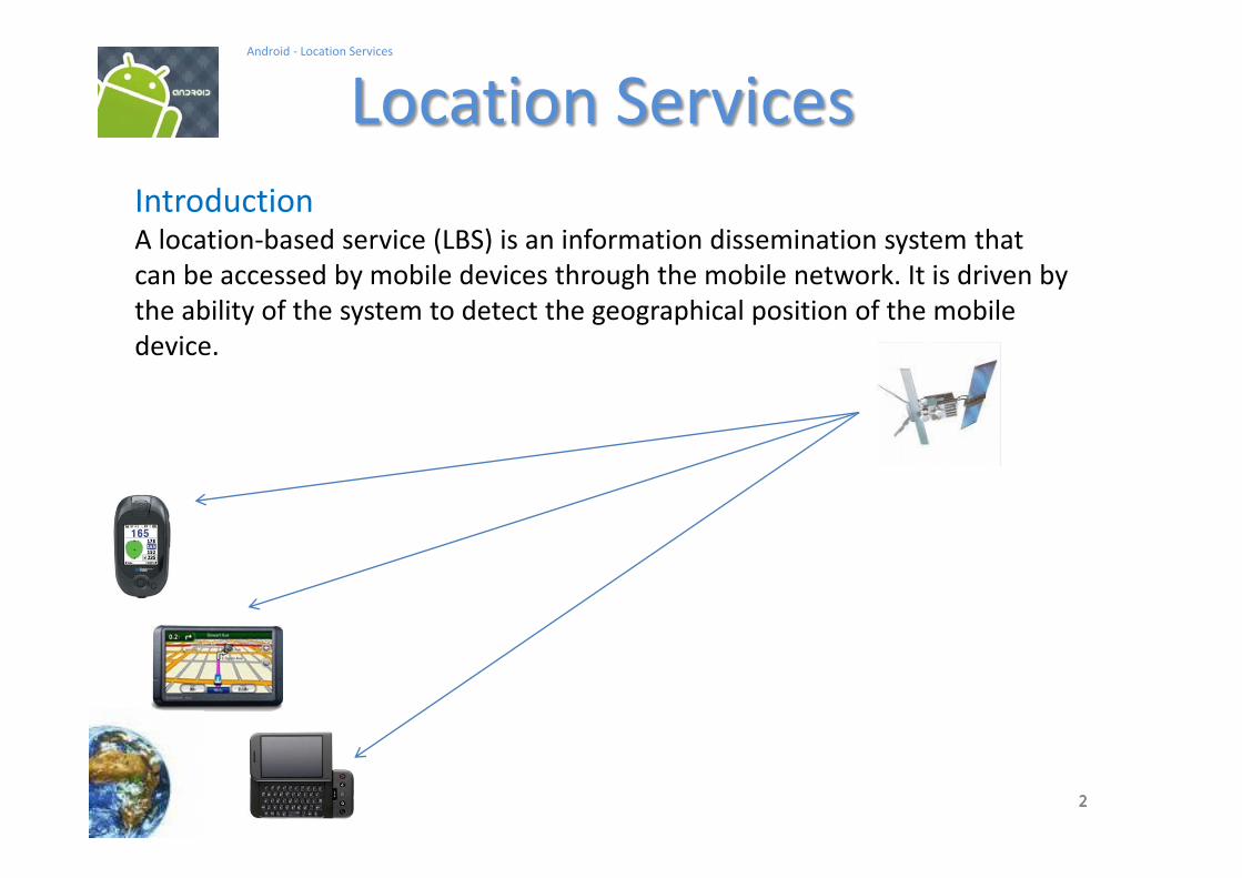
IntroductionA location-based service (LBS) is an information dissemination system that
can be accessed by mobile devices through the mobile network. It is driven by
the ability of the system to detect the geographical position of the mobile
device.
333
Android - Location Services
Location Services
3
IntroductionLocation Based Services are used in a variety of situations, such as
commercial,
entertainment,
emergency,
health,
work,
personal life, etc.
Examples:
Locate the nearest bank, restaurant, gas station, hotel, golf course,
hospital, police station, etc.
Social networking is used to locate and reach events, friends and family
members.

444
Android - Location Services
Location Services
4
How the Global Positioning System (GPS) Works?
The Global Positioning System (GPS) consists of
27 Earth-orbiting satellites (24 in operation and
three extras in case one fails).
Developed by the USA as a military navigation
system, but soon it opened to other civilian uses.
Each of these 3,000- to 4,000-pound solar-powered satellites circles the globe at about
12,000 miles (19,300 km), making two complete rotations every day.
The orbits are arranged so that at any time, anywhere on Earth, there are at least four
satellites "visible" in the sky.
A GPS receiver's job is to locate three or more of these satellites, figure out the distance to
each, and use this information to deduce its own location. This operation is based on a
mathematical principle called trilateration.
Reference: http://electronics.howstuffworks.com/gadgets/travel/gps.htm
555
Android - Location Services
Location Services
5
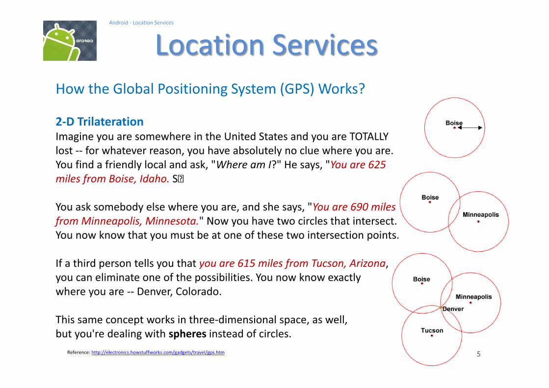
How the Global Positioning System (GPS) Works?
2-D Trilateration
Imagine you are somewhere in the United States and you are TOTALLY
lost -- for whatever reason, you have absolutely no clue where you are.
You find a friendly local and ask, "Where am I?" He says, "You are 625
miles from Boise, Idaho.
You ask somebody else where you are, and she says, "You are 690 miles
from Minneapolis, Minnesota." Now you have two circles that intersect.
You now know that you must be at one of these two intersection points.
If a third person tells you that you are 615 miles from Tucson, Arizona,
you can eliminate one of the possibilities. You now know exactly
where you are -- Denver, Colorado.
This same concept works in three-dimensional space, as well,
but you're dealing with spheres instead of circles.
Reference: http://electronics.howstuffworks.com/gadgets/travel/gps.htm

666
Android - Location Services
Location Services
6
How the Global Positioning System (GPS) Works? / Trilateration
--- Miami 1795 km
--- Caracas 1874 km
--- Bogota 1251 km
San Jose, CR

777
Android - Location Services
Location Services
7
3D-Trilateration
For a visual explanation visit: http://electronics.howstuffworks.com/gadgets/travel/gps.htm
Reference: http://electronics.howstuffworks.com/gadgets/travel/gps.htm

888
Android - Location Services
Location Services
8
3D-Trilateration
For a visual explanation visit: http://electronics.howstuffworks.com/gadgets/travel/gps.htm
Reference: http://electronics.howstuffworks.com/gadgets/travel/gps.htm

999
Android - Location Services
Location Services
9
3D-Trilateration
For a visual explanation visit: http://electronics.howstuffworks.com/gadgets/travel/gps.htm
Reference: http://electronics.howstuffworks.com/gadgets/travel/gps.htm

101010
Android - Location Services
Location Services
10
Cell Tower TriangulationAn alternative method to determine the location of a cell phone is to estimate
its distance to three nearby cell towers.
Distance of the phone to each antenna
could be estimated based upon the
lag time between the moment the
tower sends a ping to the phone and
receives the answering ping back.
Quite similar to the 2D-Trilateration
Method.
Reference: http://searchengineland.com/cell-phone-triangulation-accuracy-is-all-over-the-map-14790

111111
Android - Location Services
Location Services
11
Latitude & LongitudeLatitude in GPS-Decimal notation: +90.00000 (North) to -90.000000 (South)
Longitude GPS-Decimal notation: +180.000000 (East) to -180.000000 (West)
121212
Android - Location Services
Location Services
12
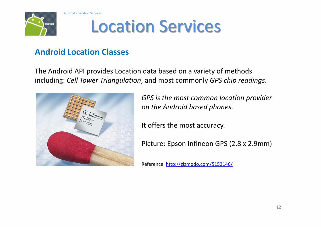
Android Location Classes
The Android API provides Location data based on a variety of methods
including: Cell Tower Triangulation, and most commonly GPS chip readings.
GPS is the most common location provider
on the Android based phones.
It offers the most accuracy.
Picture: Epson Infineon GPS (2.8 x 2.9mm)
Reference: http://gizmodo.com/5152146/

131313
Android - Location Services
Location Services
13
Android Location Classes
Address A class representing an Address, i.e, a set of strings
describing a location.
Criteria A class indicating the application criteria for selecting a
location provider.
Geocoder A class for handling geocoding.
GpsSatellite This class represents the current state of a GPS satellite.
GpsStatus This class represents the current state of the GPS engine.
Location A class representing a geographic location sensed at a
particular time (a "fix").
LocationManager This class provides access to the system location services.
LocationProvider An abstract superclass for location providers

141414
Android - Location Services
Location Services
14
Android Location Interfaces
GpsStatus.Listener Used for receiving notifications when GPS status has
changed.
GpsStatus.NmeaListener Used for receiving NMEA sentences from the GPS.
LocationListener Used for receiving notifications from the
LocationManager when the location has changed.
151515
Android - Location Services
Location Services
15
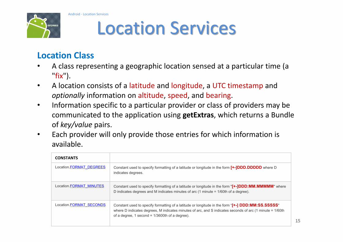
Location ClassA class representing a geographic location sensed at a particular time (a
"fix").
A location consists of a latitude and longitude, a UTC timestamp and
optionally information on altitude, speed, and bearing.
Information specific to a particular provider or class of providers may be
communicated to the application using getExtras, which returns a Bundle
of key/value pairs.
Each provider will only provide those entries for which information is
available.
CONSTANTS
Location.FORMAT_DEGREES Constant used to specify formatting of a latitude or longitude in the form [+-]DDD.DDDDD where D
indicates degrees.
Location.FORMAT_MINUTES Constant used to specify formatting of a latitude or longitude in the form "[+-]DDD:MM.MMMMM" where
D indicates degrees and M indicates minutes of arc (1 minute = 1/60th of a degree).
Location.FORMAT_SECONDS Constant used to specify formatting of a latitude or longitude in the form [+-] DDD:MM:SS.SSSSS"
where D indicates degrees, M indicates minutes of arc, and S indicates seconds of arc (1 minute = 1/60th
of a degree, 1 second = 1/3600th of a degree).
161616
Android - Location Services
Location Services
16
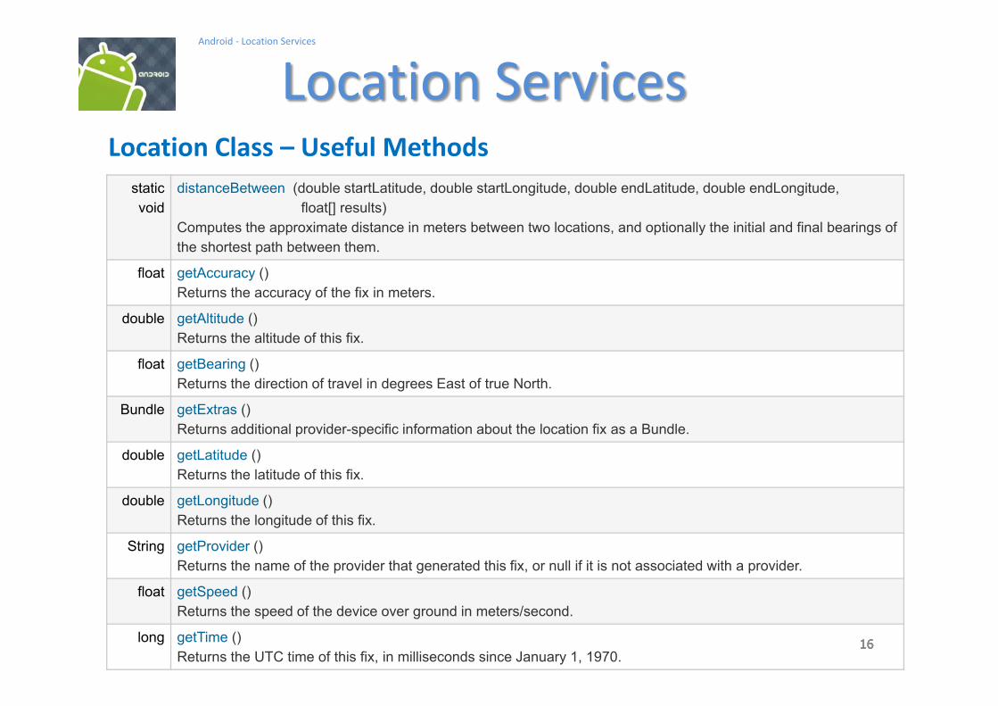
Location Class Useful Methods
static
void
distanceBetween (double startLatitude, double startLongitude, double endLatitude, double endLongitude,
float[] results)
Computes the approximate distance in meters between two locations, and optionally the initial and final bearings of
the shortest path between them.
float getAccuracy ()
Returns the accuracy of the fix in meters.
double getAltitude ()
Returns the altitude of this fix.
float getBearing ()
Returns the direction of travel in degrees East of true North.
Bundle getExtras ()
Returns additional provider-specific information about the location fix as a Bundle.
double getLatitude ()
Returns the latitude of this fix.
double getLongitude ()
Returns the longitude of this fix.
String getProvider ()
Returns the name of the provider that generated this fix, or null if it is not associated with a provider.
float getSpeed ()
Returns the speed of the device over ground in meters/second.
long getTime ()
Returns the UTC time of this fix, in milliseconds since January 1, 1970.

Android Software Stack
Sensor ManagerLocation
Manager

This class provides access to the system location services.
These services allow applications
1. To obtain periodic updates of the device's geographical
location,
2. or to fire an application-specified Intent when the device
enters the proximity of a given geographical location.
Location Manager
String service_name = Context.LOCATION_SERVICE;
LocationManager locationManager = (LocationManager) getSystemService(service_name)


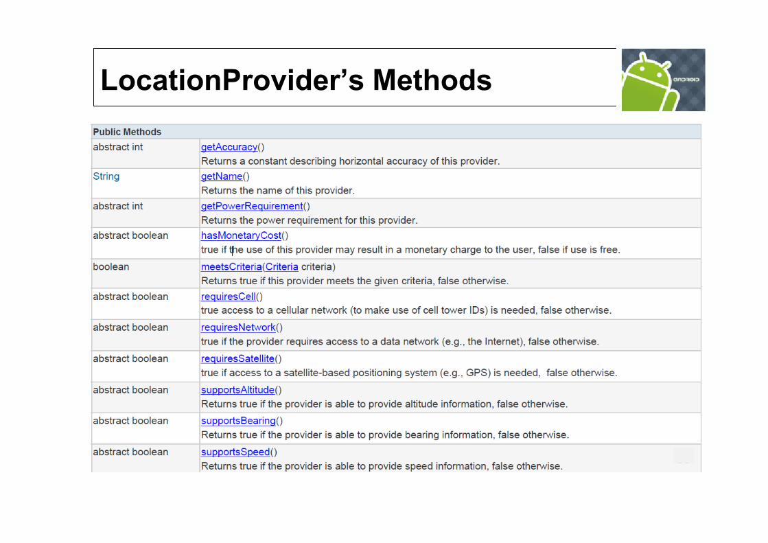
LocationProvider Class
An abstract superclass for location providers.
A location provider supplies periodic reports on the geographical
location of the device.
Each provider has a set of criteria under which it may be used; for
example, some providers require GPS hardware and visibility to a number of
satellites;
others require the use of the cellular radio,
or access to a specific carrier's network,
or access to the internet.
They may also have different battery consumption characteristics or
monetary costs to the user.
The Criteria class allows providers to be selected based on user-
specified criteria.
Methods

Provider Reference
LocationProvider Class
String providerName = LocationManager.GPS_PROVIDER;
LocationProvider gpsProvider;
gpsProvider = locationManager.getProvider(providerName);
Common Location Providers:LocationManager.GPS_PROVIDER
LocationManager.NETWORK_PROVIDER
boolean enabledOnly = true;
List<String> providers = locationManager.getProviders(enabledOnly);
Getting list of all providers

Provider with specific requirements
Finding Location Providers Using Criteria
Criteria criteria = new Criteria();
criteria.setAccuracy(Criteria.ACCURACY_COARSE);
criteria.setPowerRequirement(Criteria.POWER_LOW);
criteria.setAltitudeRequired(false);
criteria.setBearingRequired(false);
criteria.setSpeedRequired(false);
criteria.setCostAllowed(true);
String bestProvider = locationManager.getBestProvider(criteria, true);
To get all matching Providers
List<String> matchingProviders = locationManager.getProviders(criteria, false);

LocationListener Class
Used for receiving notifications from the
LocationManager when the location has changed.
These methods are called if the LocationListener has
been registered with the location manager service using
the method:
requestLocationUpdates (Provider, minTime, minDistance, LocationListener)

Methods
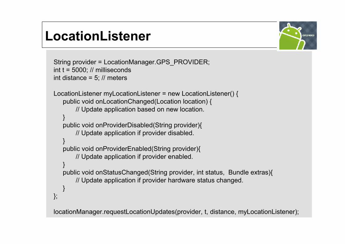
String provider = LocationManager.GPS_PROVIDER;
int t = 5000; // milliseconds
int distance = 5; // meters
LocationListener myLocationListener = new LocationListener() {
public void onLocationChanged(Location location) {
// Update application based on new location.
}
public void onProviderDisabled(String provider){
// Update application if provider disabled.
}
public void onProviderEnabled(String provider){
// Update application if provider enabled.
}
public void onStatusChanged(String provider, int status, Bundle extras){
// Update application if provider hardware status changed.
}
};
locationManager.requestLocationUpdates(provider, t, distance, myLocationListener);
LocationListener

Reference Location Manager
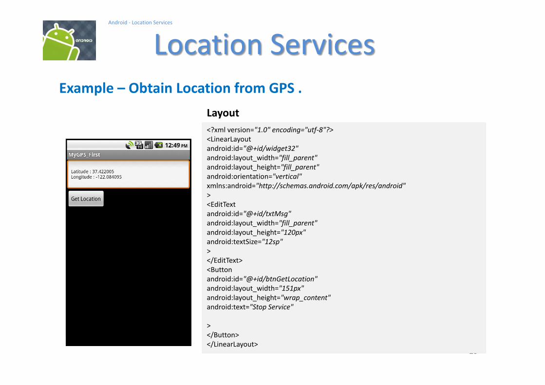
FINDING YOUR LOCATION
Permissions in Manifest
<uses-permission android:name="android.permission.ACCESS_FINE_LOCATION"/>
<uses-permission android:name="android.permission.ACCESS_COARSE_LOCATION"/>
String service_name = Context.LOCATION_SERVICE;
LocationManager locationManager = (LocationManager) getSystemService(service_name)
String provider = LocationManager.GPS_PROVIDER;
Location location = locationManager.getLastKnownLocation(provider);

In this example we request GPS services and display latitude and
longitude values on the UI.
Notes
1. Observe the GPS chip is not a synchronous device that will immediately
give me a GPS reading
2. In order to engineer a good solution that takes into account the potential
delays in obtaining location data we place the UI in the main activity and
the request for location call in a background service.
3. Remember the service runs in the same process space as the main
activity, therefore for the sake of responsiveness we must place the logic
for location data request in a separate parallel thread.
Example Obtain Location from GPS
262626
Android - Location Services
Location Services
26
Example Obtain Location from GPS .
<?xml version="1.0" encoding="utf-8"?>
<LinearLayout
android:id="@+id/widget32"
android:layout_width="fill_parent"
android:layout_height="fill_parent"
android:orientation="vertical"
xmlns:android="http://schemas.android.com/apk/res/android"
>
<EditText
android:id="@+id/txtMsg"
android:layout_width="fill_parent"
android:layout_height="120px"
android:textSize="12sp"
>
</EditText>
<Button
android:id="@+id/btnGetLocation"
android:layout_width="151px"
android:layout_height="wrap_content"
android:text="Stop Service"
>
</Button>
</LinearLayout>
Layout

272727
Android - Location Services
Location Services
27
Example Obtain Location from GPS .
<?xml version="1.0" encoding="utf-8"?>
<manifest xmlns:android="http://schemas.android.com/apk/res/android"
package="bim224.mappinggps"
android:versionCode="1"
android:versionName="1.0">
<application
android:icon="@drawable/icon"
android:label="@string/app_name"
android:debuggable="true" >
<activity android:name=".MyGPS"
android:label="@string/app_name">
<intent-filter>
<action android:name="android.intent.action.MAIN" />
<category android:name="android.intent.category.LAUNCHER" />
</intent-filter>
</activity>
<service
android:name="MyGpsService">
</service>
</application>
<uses-sdk android:minSdkVersion="2" />
<uses-permission android:name="android.permission.SEND_SMS" />
<uses-permission android:name="android.permission.ACCESS_FINE_LOCATION" />
</manifest>
Manifest

282828
Android - Location Services
Location Services
28
Example Obtain Location from GPS .
// Request GPS location, show lat & long on EditText
//
package bim224.myGps.first;
import android.app.Activity;
import android.os.Bundle;
import android.content.BroadcastReceiver;
import android.content.ComponentName;
import android.content.Context;
import android.content.Intent;
import android.content.IntentFilter;
import android.telephony.gsm.SmsManager;
import android.util.Log;
import android.view.View;
import android.view.View.OnClickListener;
import android.widget.*;
Main Activity: MyGPS
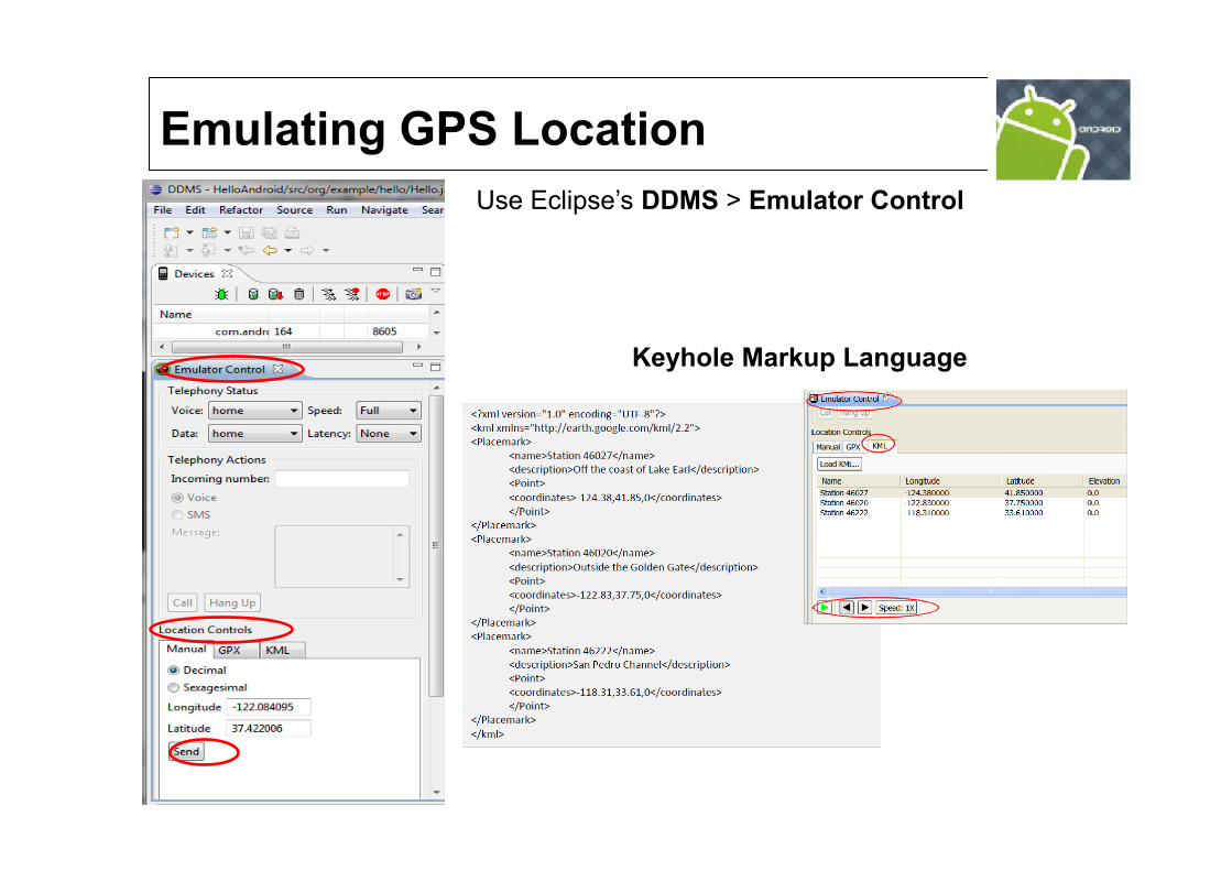
Emulating GPS Location
DDMS > Emulator Control
Keyhole Markup Language
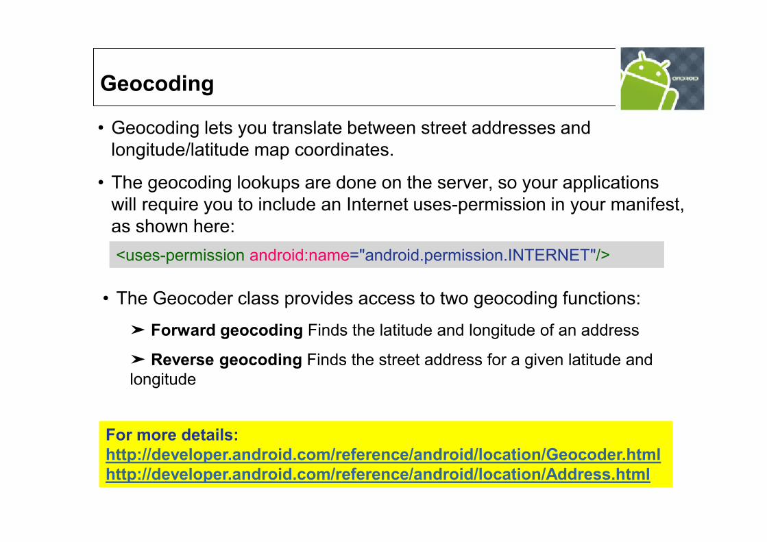
Geocoding lets you translate between street addresses and
longitude/latitude map coordinates.
The geocoding lookups are done on the server, so your applications
will require you to include an Internet uses-permission in your manifest,
as shown here:
Geocoding
The Geocoder class provides access to two geocoding functions:
Forward geocoding Finds the latitude and longitude of an address
Reverse geocoding Finds the street address for a given latitude and
longitude
<uses-permission android:name="android.permission.INTERNET"/>
For more details:
http://developer.android.com/reference/android/location/Geocoder.html
http://developer.android.com/reference/android/location/Address.html

Reverse Geocoding
location = locationManager.getLastKnownLocation
(LocationManager.GPS_PROVIDER);
double latitude = location.getLatitude();
double longitude = location.getLongitude();
List<Address> addresses = null;
Geocoder gc = new Geocoder(this, Locale.getDefault());
try {
addresses = gc.getFromLocation(latitude,
longitude, 10);
} catch (IOException e) {}
Geocoder gc= new Geocoder(context, Locale.US);
List<Address> streets = gc.getFromLocation(latitude, longitude, 1);

Forward Geocoding
Geocoder fwdGeocoder = new Geocoder(this, Locale.US);
String streetAddress = "160 Riverside Drive,
New York, New York";
List<Address> locations = null;
try {
locations =
fwdGeocoder.getFromLocationName(streetAddress, 10);
} catch (IOException e) {}
Geocoder gc= new Geocoder(this);
// get decimal coordinates for up to 5 (best) matching locations
List<Address> lstFoundAddresses= gc.getFromLocationName(txtStreetAddress, 5);
Top Related