


Languages
Pages
Legal

Data Acquisition Brief
THOMAS J. LAUTERBORN National Cartographic Information Center
U.S. Geological Survey Reston, VA 22092
Aerial Photography Summary Record System-Five Years Later
The System includes a central descriptive file of conventional aerial photography projects planned or completed by federal, state, and local agencies and private aerial mapping companies.
W HEN THE National Cartographic Information Center (NCIC) was formed in July 1974 in the
U.S. Geological Survey, one of its first undertak- ings was to establish an automated information system for conventional aerial photography projects-the Aerial Photography Summary Rec- ord System, or APSRS. This system was designed to help eliminate the growing number of duplicate projects by establishing a central descriptive file of projects planned or completed by federal, state,
and local agencies and private aerial mapping companies. By early 1975 the specifications for APSRS had been developed, and by late 1975 the first entries had been made into the system.
Considerable thought had been given to the in- formation necessary to describe properly the vari- ous projects. Because project specifications vary so widely, APSRS was designed to store detailed de- scriptions. The projects could be in the planning stage or could have been completed. To enter in-
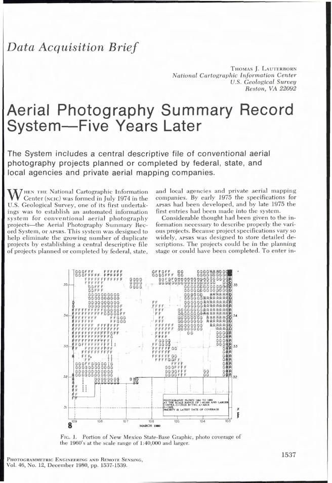
FIG. 1. Portion of New Mexico State-Base Graphic, photo coverage of the 1960's at the scale range of 1:40,000 and larger.
PHOTOGRAMMETRIC ENGINEERING AND REMOTE SENSING, Vol. 46, No. 12, December 1980, pp. 1537-1539.
PHOTOGRAMMETRIC ENGINEERING & REMOTE SENSING, 1980
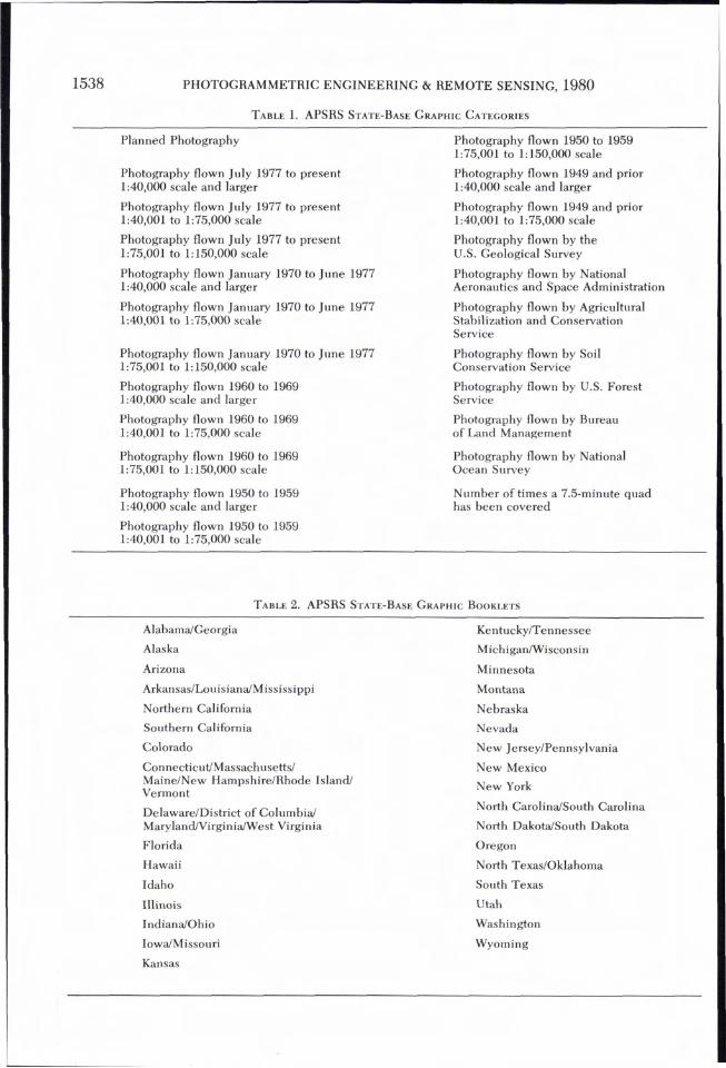
TABLE 1. APSRS STATE-BASE GRAPHIC CATEGORIES
Planned Photography
Photography flown July 1977 to present 1:40,000 scale and larger
Photography flown July 1977 to present 1:40,001 to 1:75,000 scale
Photography flown July 1977 to present 1:75,001 to 1: 150,000 scale
Photography flown January 1970 to June 1977 1:40,000 scale and larger
Photography flown January 1970 to June 1977 1:40,001 to 1:75,000 scale
Photography flown January 1970 to June 1977 1:75,001 to 1: 150,000 scale
Photography flown 1960 to 1969 1:40,000 scale and larger
Photography flown 1960 to 1969 1:40,001 to 1:75,000 scale
Photography flown 1960 to 1969 1:75,001 to 1: 150,000 scale
Photography flown 1950 to 1959 1:40,000 scale and larger
Photography flown 1950 to 1959 1:75,001 to 1:150,000 scale
Photography flown 1949 and prior 1:40,000 scale and larger
Photography flown 1949 and prior 1:40,001 to 1:75,000 scale
Photography flown by the U.S. Geological Survey
Photography flown by National Aeronautics and Space Administration
Photography flown by Agricultural Stabilization and Conservation Service
Photography flown by Soil Conservation Service
Photography flown by U.S. Forest Service
Photography flown by Bureau of Land Management
Photography flown by National Ocean Survey
Number of times a 7.5-minute quad has been covered
Photography flown 1950 to 1959 1:40,001 to 1:75,000 scale
TABLE 2. APSRS STATE-BASE GRAPHIC BOOKLETS
AlabamdGeorgia KentuckyITennessee
Alaska MichiganIWisconsin
Arizona Minnesota
Arkansas/Louisiana/Mississippi Montana
Northern California Nebraska
Southern California Nevada
Colorado New JerseyIPennsylvania
Connecticut/Massachusetts/ MaineINew HampshireIRhode Island/ Vermont
DelawareIDistrict of Columbia1 Maryland/VirginidWest Virginia
Florida
Hawaii
Idaho
Illinois
IndianaIOhio
IowdMissouri
New Mexico
New York
North CarolindSouth Carolina
North DakotdSouth Dakota
Oregon
North TexasIOklahoma
South Texas
Utah
Washington
Wyoming
Kansas

AERIAL PHOTOGRAPHY SUMMARY RECORD SYSTEM
formation into APSRS, details such as image scale, location, and flight date are coded by either NCIC
or the agency or company responsible for the ae- rial project, and then entered by NCIC into the APSRS data base.
Information in APSRS can be retrieved in a number of ways. Selected graphics are available by state as a standard product. Agencies and com- panies that have contributed records of their photo projects are given periodic reports on all the holdings in the system, and microfiche (computer listings) are generated for public sale. Also, selec- tive searches of the data base can be performed to find specific types of projects. For example, the computer can be queried to find all 1:40,000-scale color-infrared projects in Florida between 1960 and 1969.
A new APSRS product is the series of State-base graphics; map indexes, grouped by State, that show planned and completed projects at various time periods and scales or by photography owner- ship. These graphics are updated at six-month intervals. Figure 1 is a reproduction of a portion of the graphic for New Mexico, which shows photo- graphic coverage during the 1960 decade at the scale range of 1:40,000 and larger.
Twenty-three graphics are generated for each state from the APSRS data base. Table 1 lists the present categories. For a few federal agencies with
major coverage, NCIC produces indexes. All other sources are contained within the different categories. As more agencies and companies par- ticipate in APSRS and descriptions of their projects are entered into the system, more categories of graphics will be produced.
The graphics are released in a series of booklets; generally each state has its own booklet, but in some cases several states are combined for more uniform areal coverage (Table 2).
Through personal contacts and by corre- spondence, NCIC is actively seeking new con- tributors to the APSRS data base and is interested in collecting descriptions of aerial projects flown anywhere in the United States at any time. At present APSRS contains descriptions of over 100,000 projects sent in by 135 different con- tributors, including 43 federal, 23 state, and 15 local government agencies; 52 private companies; and two universities.
For more information about APSRS products or for information on how to become an APSRS con- tributor, contact the APSRS Program Manager, U.S. Geological Survey, NCIC, 507 National Center, Reston VA 22092. Telephone (703) 860-6509.
(Received 20 December 1979; revised and accepted 1 August 1980)
Forthcoming Articles
Maurice Carbonnell and Yves Egels, New Developments in Architectural Photogrammetry at the Institut Geographique National, France.
Roger R. Chamard, Photogrammetric Mapping: A Chain of Events. Stanley H . Collins, Stereoscopic Depth Perception. Stanley H. Collins and George C . Moon, Algorithms for Dense Digital Terrain Models. J . R. Gibson, A. J . Dow, and S . E . Masry, Adjustment of Position Using Inertial Navigation Systems. S . F. El Hakim and W . Faig, A Combined Adjustment of Geodetic and Photogrammetric Observations. Dr. Marsha Jo Hannah, Error Detection and Correction in Digital Terrain Models. R. M. Hodgson, F. M. Cady, and D. Pairman, A Solid-State Aircraft Sensing System for Remote Sensing. John K. Mitchell, The Pitfalls and Temptations of Aerial Mapping. F . Orti, Optimal Distribution of Control Points to Minimize Landsat Image Registration Errors. Arthur Roberts and Peter Hiscocks, A Computer Based Camera Control System. P. R. Stephens, D. L. Hicks, and N . A. Trustrum, Aerial Photographic Techniques for Soil Conserva-
tion Research. I . L. Thomas, R. Howorth, A. Eggers, and A. D. W. Fowler, Textural Enhancement of a Circular Geo-
logical Feature.
Top Related