


Languages
Pages
Legal

A broken plate beneath the North Baikal rift zone
revealed by gravity modelling
E.B. Burov, Houdry F., M Diament, Jacques Deverchere
To cite this version:
E.B. Burov, Houdry F., M Diament, Jacques Deverchere. A broken plate beneath the NorthBaikal rift zone revealed by gravity modelling. Geophysical Research Letters, American Geo-physical Union, 1994, 21 (2), pp.129-132. <10.1029/93GL03078>. <insu-01354155>
HAL Id: insu-01354155
https://hal-insu.archives-ouvertes.fr/insu-01354155
Submitted on 17 Aug 2016
HAL is a multi-disciplinary open accessarchive for the deposit and dissemination of sci-entific research documents, whether they are pub-lished or not. The documents may come fromteaching and research institutions in France orabroad, or from public or private research centers.
L’archive ouverte pluridisciplinaire HAL, estdestinee au depot et a la diffusion de documentsscientifiques de niveau recherche, publies ou non,emanant des etablissements d’enseignement et derecherche francais ou etrangers, des laboratoirespublics ou prives.
GEOPHYSICAL RESEARCH..LETrERS, VOL. 21, NO. 2, PAGES 129-132, JANUARY 15, 1994
A broken plate beneath the North Baikal rift zone revealed by gravity modelling
E. B. Burov •*, 'F. Houdry 2, M. Diament •, J. D6verch•re 2
Abstract. We modelled a 1200 km long gravimetric profile in the North Baikal rift to assess the mechanical behaviour of the
lithosphere, using a numerical model that accounts for realistic brittle-elasto-ductile rheology. We use published seismicity and re- fraction data, a new 5'x7.5' free-air/Bouguer gravity and topogra- phy data set, and a detailed map of faults obtained from high reso- lution SPOT imagery. Analysis of the gravity field over the North Baikal rift zone indicates significant asymmetry of the mechanical processes governing the deformation of the diverging sides of the rift. These anomalies cmmot be explained by a conventional con- tinuous plate undergoing extension beneath the rift zone, whereas a strong mechanical discontinuity (wedge shaped detachment zone beneath the rift axis) is able to reproduce observations. Such a discontinuous model provides a good fit to the gravity and crustal thickness data and explains the deep seismicity reported there.
Introduction
Among the present-day continental rift systems, the Baikal rift zone (BRZ) is believed to represent an archetypal rift in the initial stages of continental plate divergence. This conventional rifting model mainly implies thinning of the crust and negligible li- thospheric strength, at least in the vicinity of the rift axis, on the basis of high heat flow and intense normal faulting throughout the upper crust. However, recent studies based on depth distribution of earthquakes, flank uplift patterns, and gravity anomalies over the East African rifts [Shudofsky et al., 1987; Ebinger et al., 1989], the Rio Grande rift [Olsen et al., 1987], or BRZ [Diament and Kogan, 1990; D6verch6re et al., 1991; Ruppel et al., 1993] provide evidence for a high mechanical strength within the lithosphere subject to extension. Analytical and numerical models confirm that plate flexure must be considered in this context to explain uplifted rift flanks that rise over 1 km above the surrounding topography [e.g., Weissel and Karner, 1989; Ch6ry et al., 1992]. In the eastern BRZ, hypocenter relocations show widespread and unusual seismic deformation throughout the upper 30 km of the crust [D6verch6re et al., 1993], in a region where interpretation of seismic refraction and reflection data indicate a thicker crust (40-44 km) than in the southern rift (35-39 km) or in the surrounding stable zones (around 40 km) [Puzyrev et al., 1978; Zorin et al., 1989; Logatchev and Zorin, 1992]. In addition to the absence of crustal thinning, it was also suggested [e.g., Ruppel, 1992], that significant effective elastic thickness (Te) of the lithosphere (-50 km, [Ruppel et al, 1993]), low heat flow, deep seismicity (hypocenters as deep as 60 lox•, [D6verch6re et al., 1991; 1993]), and, finally, an absence of volcanic activity (Figure 1) suggest that the North Baikal rift (NBR) is rather atypical. In this paper, we analyse the short wavelength gravity field in order to investigate the crustal thickness variations and mechanical lithospheric properties beneath the NBR. This is done through the study of density contrasts associated with the Moho and modelling of the mechanical behaviour of the
1 Gravim6trie et G(odynamique, Institut de Physique du Globe de Paris
on leave from Institute of Physics of the Earth also at Department of Earth Sciences/GETECH, University of
Lea•ds
2 Laboratoire de Ge5odynamique Sous-Marine, Universite Paris VI Copyright 1994 by the American Geophysical Union.
Paper number 93GL03078 0094- 8534/94/93 GL-03078503.00
lithosphere along representative profiles (Figures 1, 2). We focus on the north-eastern rift, •vhere the surface expression of extension is clear, earthquake distribution related to major faults is constrained with high accuracy (+_2 km, [D6verch6re et al., 1993]), surface geology is known [Houdry et al., 1993], as are the depth and geometry of the sedimentary basins [Logatchev and Zorin, 1992]. The sedimentary basins are clearly distributed in an en- •chelon pattern over a broad area (about 300 km) where the Proterozoic and Paleozoic granitoids are more homogeneous, than across the Central and Southern BRZ located on the suture zone
between the Siberian platform and the folded mountain ranges of Caledonian Sayan-Baikal belt (Figure 1). This area is presently dominated by N160 ø extension [Doser, 1991; D6verch6re et al., 1993] that could have been preceded by an about N115 ø extension [Houdry et al., 1993]. The latter would have favoured a strike-slip component along the major border faults.
Gravity field analysis and Mechanical Modelling
We used the topography and gravity data set provided by the International Scientific Envirolmaental Centre of Russian Academy of Sciences (ISEC). It consists of 5'x7.5' free air (FAA) and com- plete Bouguer gravity anomaly (BA) grids, including terrain cor- rections (within 200 km of gravity stations), and corresponding ele- vations (Figure 2). The resolution of the original point data is re- ported to be around l'x 1', the accuracy of FAA is about 2-4 mgal [M. Kogan, pers. comm.]. The digital topography was checked with the ONC topography (Operational Navigational Charts, De- fence Mapping Agency) and showed a good agreement in the study area (Figure 3). To separate the lithospheric and deep sub-li- thospheric sources of the observed gravity anomaly, we computed a sum of 10 first harmonics of the gravity field (GRIM-3L1 global field model [Reigber et al., 1985]). This long wavelength compo- nent appears to provide only a slight negligible EW trend of 0.5-1 mgal per 100 kna (Figure 3). To constrain the sediment thickness in the basins, the faults geometry and the crustal thickness, we used topographic cross-sections combined with geophysical data from Puzyrev et al. [1978], Zorin et al. [1989], Krylov et al. [1990], Logatchev and Zorin [1992] and D6verch6re et al. [1993]. The original complete BA, provided by ISEC, adopts crustal density of 2300 kg/m 3. Using the original FAA, we extracted the terrain corrections from the old complete BA and recomputed BA for more realistic value of 2670 kg/m 3 (Figure 2). To account for surficial density variations, we also corrected BA over the sedimentary basins for the effect of sedimentary fill, assuming density of sedi- ments p=2400 kg/m 3. This correction does not exceed 10-15 mGal. We did not account for the dense batholith inclusions reported on the north side of the rift [Yu. Zorin, pers. comm.], due to the ab- sence of data on their exact location, depth and geometry.
The linear shape of the gravity anomaly in the northeast direc- tion (direction of the rift axis, Figures 1, 2) advocates for 2D analysis. We compiled data along seven 1200 km profiles in the di- rection of the present day extension (roughly perpendicular to the major structures of the axial Upper Angara Basin, Figures 1, 2). A 800 km segment of the most representative profile A'-A is shown in Figure 3. Analysis of the Bouguer gravity profiles reveals sig- nificant deviations from the local (Airy) isostatic equilibrium model (Figure 3). The major signature of the deviations is the positive anomaly of about 40-50 mGal observed 100-150 km to the north- west of the rift axis (Upper Angara basin) and the asynunetric negative anomaly observed 100-150 km to the south of the rift axis (Tsipa-Baunt Basin). The topography far to the north of the Upper Angara Basin is too low and flat to trace out any significant differ- ence between local and regional compensation.
129
130 Burov et al.: Broken Plate Beneath the North Baikal Rift Zone
95øE 100øE 105øE
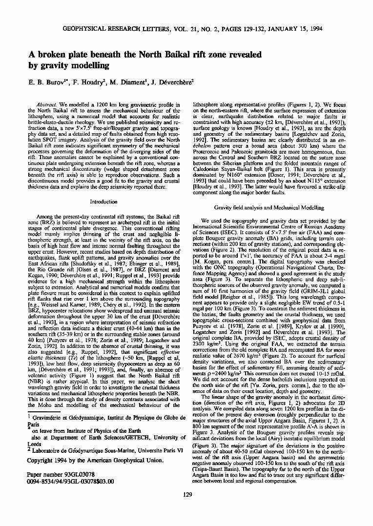
I Cenozoic sediments (Baikal rift zone) ,[• Mesozoic (Triassic) volcanic rocks • Cenozoic volcanic roks (Baikal rift zone) • Paleozoic sediments (Siberian Platlbrm - I• Mesozoic sediments •_• Paleozoic granitoids ( Sayan-Baikal Caledonian Belt)
UP, - Upper Angara Basin; I'T%-'l Arcbean, Pmterozoic rocks ( S-B Caleck•nian Belt) [JM - Upper Muya Basin; TB - Tsipa-Baunt Basin; SP - Siberian Platform
Fig. 1. Geological context of the Baikal rift zone (simplified from the Geological World Atlas, UNESCO, 1976). The line (A-A') is a 800 km part of the representative gravimetric profile used for this study (Figures 2, 3 and 4). White arrows are the directions of ex- tension obtained from stress tensor analysis (for the northern part of the rift, D6verch6re et al. [ 1991; 1993]; for the middle part of the rift, Doser [1991]). Thin black arrows are the direction of fault movement from geological observations, including field scarp measurements and SPOT imagery analysis [Houdry et al., 1993].
To explain BA over the rift, we first tried several traditional continuous plate models of regional (flexural) compensation of the topography. We began from the simple flexural models based on elastic plate approximation and end with more realistic plasto-
100' 60*
Baikal. Free-Air gravity anomaly
Bouguer bg
105' 110 ø 58 N
55 N
55* 55 ø
50* 50 ø
100 ø • 105 ø 110 ø 115 ø
i i i ..... i ' i i i i i i i i i
-120-100 -80 -60 -40 -20 0 20 40 60 80 100 120 140
FAA. Ag [mgal] ß
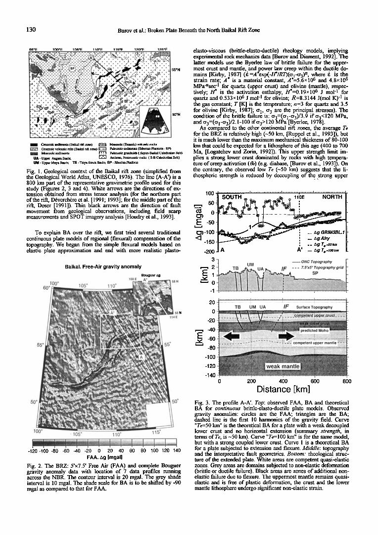
Fig. 2. The BRZ: 5'x7.5' Free Air (FAA) and complete Bouguer gravity anomaly data with location of 7 data profiles running across the NBR. The contour interval is 20 mgal. The grey shade interval is 10 mgal. The shade scale for BA is to be shifted by -90 mgal as compared to that for FAA.
elasto-viscous (brittle-elasto-ductile) rheology models, implying experimental rock mechanics data [Burov and Diament, 1992]. The latter models use the Byeflee law of brittle failure for the upper- most crust and mantle, and power law creep within the ductile do- mains [Kirby, ,1987] (• =A*exp(-H*/R•(Ol-O3) n, where • is the strain rate; A is a material constant, A*=5.6xlO 6 and 4.8x10⁶ MPa-nsec 4 for quartz (upper crust) and olivine (mantle), respec- tively; H* is the activation enthalpy, H*=0.19x 10⁶ J mol 4 for quartz and 0.533x 10⁶ J mo1-1 for olivine; R=8.3144 J(mol K) q is the gas constant; T [K] is the temperature; n=3 for quartz and 3.5 for olivine [Kirby, 1987]; o•, o 3 are the principal stresses). The condition of the brittle failure is: o3=(Ol-O3)/3.9 if o3c120 MPa, and o3=(Ol-O3)/2.1-100 if o3• 120 MPa [Byedee, 1978].
As compared to the other continental rift zones, the average Te for the BRZ is relatively high (•50 km, [Ruppel et al., 1993]), but it is much lower than the maximum mechanical thickness of 80-100
km that could be expected for a lithosphere of this age (400 to 700 Ma, [Logatchev and Zorin, 1992]). This upper strength limit im- plies a strong lower crust dominated by rocks with high tempera- ture of creep activation (&) (e.g. diabase, [Burov et al., 1993]). On the contrary, the observed low Te (•50 km) suggests that the li- thospheric strength is reduced by decoupling of the strong upper
1co
50 o
-5o
!:•-1oo
-15o
-200
,,,,,,, ............ i ................... ! ................... i ...................
SOUTH • • ^ 11bE NORTH
'
' I _ AgAiry , __ A g T e =50 km
A A' _ Ag Te=,OOkm
20
0
-20
-40
-60 -80
-100
-120
-140
3 •{ UM •ONC Topography • 2 -] TB j•,,•_ UA • IF .... 7.5'x5' Topography grid
E I , !•:..:..• •ii '•:•i-•-i•i•....,,. .... SP ................... i ................... i ................... i ...................
• ...• ................................................. • ................................................................. • .................................................................... TB UM UA IF Surface Topography • •• •,•;• • •a-t•.•••• • •'•x• .• :• ,• •.• 7'•7 .• • :.• .• •. •:•: • ,' :. 7:: :: ;-.-:; .; ;; .;.;. :.:.; :•:....
ß •.. - . ,
.
0 200 600 800 400
Distance [km]
Fig. 3. The profile A-A'. Top: observed FAA, BA and theoretical BA for continuous brittle-elasto-ductile plate models. Observed gravity anomalies: circles are the FAA; triangles are the BA; dashed line is the first 10 harmonics of the gravity field. Curve "Te=50 km" is the theoretical BA for a plate with a weak decoupled lower crust and no horizontal extension (summary strength, in tern•s of Te, is -50 km). Curve "Te= 100 km" is for the same model, but with a strong coupled lower crust. Curve 1 is a theoretical BA for a plate subjected to extension and flexure. Middle: topography and the interpretative fault geometries. Bottom: rheological struc- ture of the extended plate. White areas are competent quasi-elastic zones. Grey areas are domains subjected to non-elastic deformation (brittle or ductile failure). Black areas are zones of additional non- elastic failure due to flexure. The uppermost mantle remains quasi- elastic and is free of plastic deformation, the crust and the lower mantle lithosphere undergo significant non-elastic strain.
Burov et al.: Broken Plate Beneath the North Baikal Rift Zone 131
crust from the uppermost mantle by a weak (low 0,) lower crust [Burov et al., 1993]. Therefore we chose low Oa rheology (e.g. quartz) for the whole crust. This choice is partly validated by the presence of an intracrustal low velocity zone in the BRZ [Puzyrev, 1981], which might be associated with the weak lower crust.
A 2-D finite difference model accounting for the plasto-elasto- viscous behaviour of the continental lithosphere was used to study geologically realistic scenarios of plate deformation. The evolution of the system is governed by mass, momentum and energy conser- vation equations [e.g., Bassi, 1991; Ch6ry et al.; 1992]:
{pdetG=p0' divo+pg = 0; pCpJ•+div(kVT)=Hr+Hd}
where P0, P are the initial and currein densities, G is the gradient of deformation, g is the gravity acceleration, c• is the stress tensor, Cp is the specific heat (p Cp=3X 10⁶, 4x 10⁶ J (mSK) -1 for the crust and the mantle, respectively), k is the thermal conductivity tensor (k0'=2.5, 2, 3.5 W (mK) 4 for the upper crust, lower crust and the mantle respectively), H r and H a are the radiogenic and dissipative heat production per unit volume [Burov et al., 1993]. To achieve rapid convergence of the non-linear finite difference algorithm, we use a semi-analytical non-elastic plate approximation [Burov and Diament, 1992] for the predictor/corrector scheme controlling the effective bending moment A/I x, the longitudinal (Tx) and the vertical shearing (Qx) force components per unit width of the plate:
Mx = - I C• xx ( y - yi )dy ' Tx = - I C• xxdy ; Qx = - I C• xydy 0 0 0
(Yi is the depth to the ith neutral plane). The starting temperature distribution and yield-stress profiles were obtained from the solu- tion of the heat transfer problem for the continental lithosphere [Burov et al., 1993], assuming thermal age of 400 Ma and • -•1+3 x10 -1• sec 4 [Ruppel, 1992; Houdry et al., 1993]. Initialisation of necking requires an initial localised strength defect. Such defect was inferred beneath the axial Upper Angara basin (major de- pressed zone). We use information on the geometry and location of normal faults, deduced from high resolution SPOT imagery, field measurements [Houdry et al., 1993] and seismicity data [D6verch•re et al., 1993] to consider fault-induced stresses.
Results and Discussion
The general result of these analyses is to show that continuous plate models of lithospheric extension fail to reproduce the ob- served gravity anomalies (Figure 3). Models of lithospheric flexure without extension produce BA that do not differ enough from the Airy anomaly (Figure 3). Models of extension with flexure [e.g., Ch6ry et al., 1992], that results in a crustal/mantle necking beneath the rift axis and consequent flexural uplift of the rift shoulders, yield a quasi-syrmnetric BA over the NBR (curve 1 in Figure 3), whereas the observed BA is anti-synm•etric. Moreover, extension of a 400 Ma continuous plate gives a relatively broad (80-100 km in width) elevation of the Moho. This is larger than the width of the extensional province (<45 km), whereas the data suggest that the crust is not elevated beneath the NBR [Puzyrev et al_., 1978; Zorin et al., 1989; Logatchev and Zorin, 1992], except a possible narrow uplift beneath the Angara Basin [Krylov et al., 1990].
Geological and morphological observations [Houdry et al, 1993] reveal a significant amount of past ESE/WNW strike-slip move- ment oblique to the direction of the present-day extension, obtained from stress tensor analysis [D6verch•re et al., 1991] (Figure 1). The free strike-slip movements along the major border faults imply a mechmfical discontinuity that could have allowed the relative displacements of the rift sides, oblique to the direction of the ex- tension. The existence of such free displacements means that at least the crustal domains of the diverging rift sides should be me- chanically cut (or "torn off') from each other. We tested this point by introducing a detached zone beneath the rift axis. This zone (wedge-shaped prism or block) is bounded from both sides by near- vertical zero strength free-slip bands (border faults, Figure 4). The.
5O
'=--' -100
<• -150 -200
20
0
-20
,--, -40
[;::: -60 -80
-100
-120
-140
SOUTH 117E NORTH 2 ,•,• ...-,
•A
_ •2•LLL..•L2•L•LLL•..:..•..;..[•.•.L2X2.•LL•...L•..LL2.....•.•.•2.Z.2.•..•...L•.L•.•.•.22•..?..•..2•2..L•2....2•2"LLL2. _ TB UM UA I IF Surface Topography
"•'•..--•1 •.•;4•.• • •'...•.•..•.•`.•::7•.-•..•`•;;.`.:;::•`•:.•:;:.:•:•:;:`•.•:::.:•;:::;•;•:•:•:•::::•: .............. ; ....... :•:•:•;:•5.•:.•;:5:;:;•?, .... •::•::•::•;:•:: i -:57.;:::::.•5•-; •::,:; :::::::::::::::::::::::::::::::::::::::::::::::::::::::::::::::::::::::::::::::::::: •: ::; ====================================================
.................................. ,'; ......................
' ::::::::::::::::::::::::::::::::::::::::::::::::::::::::::::::::::::::::::::::::::::::::::::::: i ::::::::::::::::::::::::: •::•::•?:::•?:•::•::::•::;?i:•l :;•?&?•$:-:•:•;::4 :: compelertl u•er manfie [;•.•::•::•:.::;:?:;::;:•;;•;•;;;•::•;•:•'A::.;•:. • -½.•:•:::•5:•:::•:•:• •Sg::•::•;•::•::::•:::•:::::.*•;•i •:.•}::•::•:• ..................................... , ............................... •:•
•:•:::::•}:•½•;•:•;•:•:•;•:;-•:;;½•;;:•.;:•-:•.:•::•:•:;?::•-; •..: ..'•5½:'::; ::;:;:;:•:::•';:•:•:;:•:•:•.•.•-;':• ============================================================•:.::::::•:•::::.;:•.;:;:;•:•::•:•:•:•:•:;:•;:•:•:•;;•:•;•;5:;•;;;:::•:;::.•:;:?•:•.;:•:•:::•:::{:•5:•:;:•:;:•:::;:•:::::::•
. '• --• • , • ...... .
• ,':•"• :•" '•'"W•'•"•A mantle . ß •,. :{ ........
0 200 400 600 800
Distance [km]
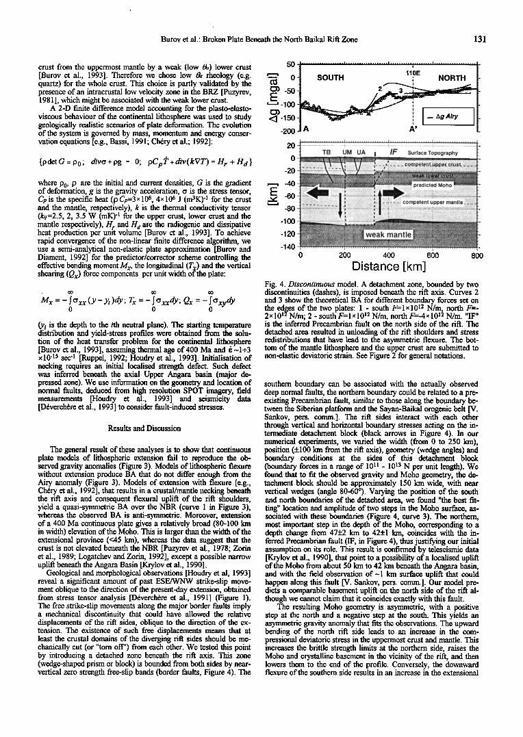
Fig. 4. Discontinuous model. A detaclunent zone, bounded by two discontinuities (dashes), is imposed beneath the rift axis. Curves 2 and 3 show the theoretical BA for different boundary forces set on
the edges of •e two plates: 1 - south F=lx 1012 N/m, north F=- 2x10¹²N/m; - south F=lx10 •2 N/m, north F=-4x10 •2 N/m. "IF" is the inferred Precambrian fault on the north side of the rift. The detached area resulted in unloading of the rift shoulders and stress redistributions that have lead to the asynm•etric flexure. The bot- tom of the mantle lithosphere and the upper crust are submitted to non-elastic deviatoric strain. See Figure 2 for general notations.
southern boundary can be associated xvith the actually observed deep normal faults, the northern boundary could be related to a pre- existing Precambrian fault, similar to those along the boundary be- tween the Siberian platform and the Sayan-Baikal orogenic belt [V. Sankov, pers. conm•.]. The rift sides interact with each other through vertical and horizontal boundary stresses acting on the in- tennediate detaclunent block (black arrows in Figure 4). In our numerical experiments, we varied the width (from 0 to 250 km), position (+100 km from the rift axis), geometry (wedge angles) and boundary conditions at the sides of this detacluent block (boundary forces in a range of 10 ]] - 1013 N per unit length). We found that to fit the observed gravity and Moho geometry, the de- tachment block should be approximately 150 km wide, with near vertical wedges (angle 80-60ø). Varying the position of the south and north boundaries of the detached area, we found "the best fit- ting" location and amplitude of two steps in the Moho surface, as- sociated with these boundaries (Figure 4, curve 3). The northern, most important step in the depth of the Moho, corresponding to a depth change from 47+2 km to 42+1 km, coincides with the in- ferred Precambrian fault (IF, in Figure 4), thus justifying our initial assumption on its role. This result is continned by teleseismic data [Krylov et al., 1990], that point to a possibility of a 1ocalised uplift of the Moho from about 50 km to 42 km beneath the Angara basin, and with the field observation of-1 km surface uplit• that could happen along this fault [V. Sankov, pers. comm.]. Our model pre- dicts a comparable basement uplift on the north side of the rift al- though we cannot claim that it coincides exactly with this fault.
The resulting Moho geometry is asymmetric, with a positive step at the north and a negative step at the south. This yields an asynm•etric gravity anomaly that fits the observations. The upward bending of the north rift side leads to an increase in the com- pressional deviatoric stress in the uppermost crust and mantle. This increases the brittle strength limits at the northern side, raises the Moho and crystalline basement in the vicinity of the rift, and then lowers them to the end of the profile. Conversely, the downward flexure of the southern side results in an increase in the extensional
132 Burov et al.: Broken Plate Beneath the North Baikal Rift Zone
deviatoric stresses in the uppermost crust and mantle, and therefore decreases the limits of the brittle failure. This could explain the asymmetry in the seismicity and fault distributions on opposite sides of the NBR (Figure 3 and 4). The geometry of the detached area roughly coincides with the geometry of a system of normal faults that bound the basin and penetrate the lower crust at depths up to 30 km [D6verch•re et al., 1993]. This area could be caused by tearing off of the rift neck during extension, e.g. by the past ESE/WNW strike-slip movement, oblique to the direction of diver- gence (the strike-slip component is now minor, probably afler re- orientation of the major stress axes from Nl15 ø to N160 ø [D6verch•re et al., 1993]). This could result in the drop of the de- viatoric stresses at the edges of the diverging rift sides and conse- quently in the elastic unloading of its shoulders, which has led to the practical restoration of their initial strength: the effective Te be- came quite high, of about 45-55 km, compared to 20-30 km that could be expected in the neck of a classical rifl. Due to the asym- metric load redistribution that followed the interruption in horizon- tal stress transition, one of the shoulders (south) went 1-2 km down and the other one (north) •vent 4-5 km up. The "tom-off" neck is not a single possible mechanism that could explain the detachment of the north and south rift sides. The other possibility could be a large scale extensional "cracking" of the lithosphere due to hetero- geneous stress/strain field created by the complex northwards movement of the Indian continent [Tapponnier and Molnar, 1979].
Conclusions
The analysis of the short wavelength gravity field in the light of seismological and geological data suggests that the NBR presents a quite untypical "broken" or "cracked" rift. We believe that the pre- sent behaviour of the diverging plates in the NBR is not associated with conventional rifling by stretching of the continuous litho- sphere, but requires a mechanical discontinuity (block-like detach- ment zone) beneath the rift axis. Due to this detachment zone (its existence is confirmed by the past strike-slip faulting, supposedly resulting from the Asia-India collision [Tapponnier and Molnar, 1979]), the mechanical interaction between the sides of the rift is minor in the direction of divergence, resulting in that the li- thospheric deformation is well explained by the flexural up- lift/descent of the both detached sides of the rift.
Acknowledgements. We thank ISEC for access to their gravity data set, M. G. Kogan and Yu. Zorin for helpful comments on the manuscript. We are especially indebted to C. Ebinger for her gen- erous help in correcting the manuscript and constructive comments. We thank C. Ruppel for useful comments and providing parts of her thesis. E. B. Burov benefited from a post-doctoral grant of the Minist•re de la Recherche and from partial support of GETECH. This work was partly supported by INSU-DBT (92), and Tec- toscope (92). Contribution # 1280 (IPGP), # 637 (GEMCO).
References
Bassi, G., Factors controlling the style of continental rifling: in- sights from numerical modelling, Earth Planet. Sci. Lett., 105, 430-452, 1991
Byeflee, J.D., Friction of rocks, Pure Appl. Geophys., 116, 615- 626, 1978.
Burov, E.B., and M. Diament, Flexure of the continental lithosphere with multilayered rheology, Geophys. J. Int., 109, 449-468, 1992.
Burov, E.B., Lobkovsky, L.I., Cloetingh, S., and A.M. Nikishin, Con- tinental lithosphere folding in Central Asia (part 2), constraints from gravity and topography, Tectonophysics, 226, 73-87, 1993.
Ch6ry, J., Lucozeau, F., Daignieres, M., and J.P. Villotte, Large uplift of rift flanks: A genetic link with lithospheric rigidity?, Earth Planet. Sci. Lett., 112, 195-211, 1992.
D6verch•re, J., Houdry, F., Diament, M., Solonenko, N.V. and A.V. Solonenko, Evidence for a seismogenic upper mantle and lower crust in the Baikal rift, Geophys. Res. Letters, 18, 6, 1099-1102, 1991.
D6verch6re, J., Houdry, F., Solonenko, N.V., Solonenko, A.V., and V.A. Sankov, Seismicity, active faults and stress field of the North Muya Region, Baikal Rifl: New insights on the rheology of extended continental lithosphere, J. Geophys. Res., 1993.
Diament, M., and M.G. Kogan, Long wavelength gravity anomalies over the Baikal rift and geodynamic implications, Geophys. Res. Lett., 17, 11, 1977-1980, 1990.
Doser, D., Faulting within the eastern Baikal rift as characterised by earthquake studies, Tectonophysics, 196, 108-139, 1991.
Ebinger, C.J., Bechtel, T.D., Forsyth, D.W. and C.O. Bowin, Effective elastic plate thickness beneath the East African and Afar Plateaux and dynamic compensation of the uplifls, J. Geophys. Res., 94, 2883-2901, 1989.
Kirby, S.H., and A.K. Kronenberg, Rheology of the Lithosphere: Selected Topics, Rev. Geophys., 25, 1219-1244, 1987.
Krylov, S.V., Mishenkin, B.P., and A.V. Bryskin, Deep structure of the Baikal rift zone from multiwave seismic investigations, in: Logatchev, N.A. and Yu.A. Zorin (Eds.), Geodynamics of intracontinental mountainous terrains (in Russian), Nauka, Novosibirsk, 162-169, 1990.
Houdry, F., Gaudemer, Y., Sankov, V., and J. D6verch•re, Geometry and rate of faulting during the Holocene in the North Baikal Rift Zone, Abstr. suppl. NøI to Terra Nova, 5, EUG VII Strasbourg, C09-30, 259, 1993.
Logatchev, N.A., and Y.A. Zorin, Baikal rift zone: Structure and geodynamics, Tectonophysics, 208, 273-286, 1992.
Olsen, K.H., Baldridge, W.S., and J.F. Callender, Rio Grande Rifl: An overview, Tectonophysics, 143, 119-139, 1987.
Puzyrev, N.N., Mandelbaum, M.M., Krylov, S.V., Mishenkin, B.P., Petrik, G.V., and G.V. Krupskaya, Deep structure of the Baikal and other rift zones from seismic data, Tectonophysics, 45, 15-22, 1978.
Puzyrev, N. (Ed.), Baikal interiors according to the seismic data (in Russian), Izd. Akad. N. Sib. Otd., Novosibirsk, 1981.
Reigber C., Balmino G., Miller H., Bosch W., and B. Moynot, GRIM gravity model improvement using LAGEOS (GRIM3- L 1), •1. Geophys. Res., 90, 7285-7299, 1985.
Ruppel, C. D, Thermal structure, compensation mechanisms, and tectonics of actively deforming continents: Baikal rift zone and large scale overthrust and extensional terrains, Ph.D. thesis, Mas. Inst. of Technology, 292 p., 1992.
Ruppel, C. D, Kogan, M. G., and M. K. McNutt, Implications of new gravity data for Baikal rift zone structure, Geophys. Res. Lett., 20, 1635-1638, 1993.
Shudofsky, G.N., Cloetingh, S., Stein, S., and R. Wortel, Unusually deep earthquakes in East Africa: Constraints on the thermo-mechanical structure of a continental rift system, Geophys. Res. Lett., 14, 7, 741-744, 1987.
Tapponnier, P., and P. Molnar, Active faulting and Cenozoic tectonics of the Tien Shan, Mongolia, and Baykal regions, •1. Geophys. Res., 84, 3425-3459, 1979.
Weissel, J.K., and G.D. Kamer, Flexural uplift of rift flanks due to mechanical unloading of the lithosphere during extension, o[. Geophys. Res., 94, 13919-13950, 1989.
Zorin, Yu.A., Kozhevnikov, V.M., Novoselova, M.R., and E.K. Turutanov, Thickness of the lithosphere beneath the Baikal rift zone and adjacent regions, Tectonophysics, 168, 327-337, 1989.
E. B. Burov and M. Diament, Lab. Gravim6trie et G6ody- namique, IPGP, 4 Place Jussieu, 75252 Paris Cedex 05, France
F. Houdry and J. D6verch•re, Lab. de G6odynamique Sous- Marine - BP 48, 06230 Villefranche-sur-mer, France.
(Received: August 10, 1993; revised: October 18, 1993;
accepted October 28, 1993)
Top Related