


Languages
Pages
Legal


2017–18 Teck Access Boundaries in the Elk Valley
Fording RiverOperationsPage 2
GreenhillsOperationsPage 3
Line CreekOperationsPage 4
ElkviewOperationsPage 5
Coal MountainPhase 2
Page 66Coal MountainOperationsPage 6
Flathead TownsiteConservation Land
Page 7
Alexander CreekConservation LandPage 7
Grave PrairieConservation LandPage 7
Flathead River
HWY
3H
WY
43
Corbin Highway
HW
Y 43
HWY 3
Hosmer
Fernie
Elkford
Sparwood
Corbin
Elk
River
FordingRiver
Brûlé Creek
Coal Creek
Cumm
ings
Creek
Boivin Creek
Leac
hC
reek
Weigert Creek
Forsyth Creek
Ewin C reek
Telford Creek
Marten
Creek
Michel Creek
Grave Lake
Summit Lake
Harriet Lake
Hartley Lake
For your safety and ours, please observe the no entry, no hunting and no shooting boundaries on Teck property in the Elk Valley. Electronic maps and coordinates at: www.teck.com/coalmaps

#
#
#
#
##
# No Unauthorized EntryNo Hunting
No Trespassing
Elk
Riv
er
Posted Cutline
Fording Mine Road
Powerline
Round Prairie R
d
Elk Main Rd
Former 2016 boundary100 ha newly opened
Former 2016 boundary120 ha newly closed
Former 2016 boundarynewly opened
Henretta Creek
McQuarrie Creek
Cha
uncey
Cree
k
Wilde Creek
Le ask Creek
Mickelson Cre
ek
Porte
r Cre
ek
Wade Creek
Wolfram Creek North
Willo
wCre
ek
North
Willow Creek South
Swift Creek
FordingRiver
F ording River
Ford
ing
Riv
er
Wolf Creek
Ford
ing
River
Osborne Creek
Kilmarnock Creek
Fording River
Brownie Creek
Britt Creek
CPR
Road
Kilmarnock Access Road
Powerline
Road
Height of Land
Heightof Land
McM
illan Creek
Unn
amed
Cre
ek
Posted Cutline
Posted Cutline
Posted Cutlin
e
Post
ed C
utlin
e
Posted Cutline
Posted Cutline LakeMountain
Lake
HenrettaLake
In Pit LakeMount
Holcroft
MountScrimger
MountEtherington
Mount Pierce
Mount TurnbullMount
Farquhar
Old FordingFire Lookout
2400
2000
1800
1600
24002200
2200
2000
1800
26002400
2400
1800
2400
1800
2400
2200
1800
1800
1600
180016
00
200018001600
2000
18001600
20001800
2200
2000
18001600
2400
2000
2000
1800
2200
2000
2200
2000
2200
1800
2000
1800
1600
2000
1800
1600
2200
2000
2000
1800
2000
1800
2000
1800
2000
1800
2000
1800
1600
1400
2200
2200
1800
2200
2000 2000
2000
1800
2200
2000
2000
2000
2200
2200
2200
22002200
2000
2200 2200
2200
1800
2000
1800
2000
2000
2000
2000
2000
1800
1800
1800
1800
1600
1400
2000
1800
1800
646000
646000
648000
648000
650000
650000
652000
652000
654000
654000
656000
656000
658000
658000
660000
660000
5554
000
5554
000
5556
000
5556
000
5558
000
5558
000
5560
000
5560
000
5562
000
5562
000
5564
000
5564
000
5566
000
5566
000
5568
000
5568
000
5570
000
5570
000
2.5km
LegendCurrent BoundaryBoundary Changes since 2016
Date: 8/1/20172 | Teck Access Boundaries 2017–2018
For your protection and ours, observe and follow the No Unauthorized Entry, No Shooting and No Hunting boundaries.
Mining activities can start avalanches or rock slides without warning.
Maps should be used for reference only—follow field signage at all times.
In 2017, 120 ha of land in north-west area has been closed in order to ensure public safety as North Spoil progresses and to match signage to cutblock boundaries to reduce confusion by area users.
100 ha of land has been re-opened for public access in Kilmarnock Creek area.
Fording River Operations
For more information: Go to the main gatehouse and contact Loss Prevention on the radio or call Loss Prevention at 250.865.5016. Electronic maps and coordinates at www.teck.com/coalmaps

Bow HuntingOnly
Bow HuntingOnly
Elk
Riv
er
Fording Mine Road
Municipal No Shooting Area
Powerline
Round Prairie Rd
Elk Main Rd
Lookout
Posted
Cutblock
PostedR
oad
Rail Loop
CPR
Posted Cutline
GH
O1
Powerline
No Unauthorized EntryNo Hunting
No Trespassing
Dry
Creek
Gre
enhi
llsC
reek
Todh
unte
r Cre
ek
Chauncey
Cree
k
Ewin Creek
Gardine
Creek
Wilde Creek
Thompson
Creek
Le ask Creek
Mickelson Cre
ek
Porte
r Cre
ek
Wade Creek
Wolfram Creek So uth
Wolfram Creek North
Willo
wCre
ekNorth
Willow Creek South
Swift Creek
Upp
erTh
omps
on
Creek North
Thompson Creek
F ording River
Ewin Creek
Wolf Creek
North T
homps
on C
reek
Height of Land
20001800
1600
1400200018001600
1800
1600
20001800
1600
1800
1600
2000
1600
18001600
2000
1800
2000
1800
1600
2000
1600
2000
1800
20001800
1600
1800
1400
1600
1400
2000
1800
2000
1800
1800
1600
2200
2200
1800
1600
1600
2000
1600
1400
1600
2200
1800
1800
2000
2000
1800
20002000
2000
2000
2000
1800
1600
1600
1800
1400
1400
1400
1600
646000
646000
648000
648000
650000
650000
652000
652000
654000
654000
656000
656000
658000
658000
5544
000
5546
000
5546
000
5548
000
5548
000
5550
000
5550
000
5552
000
5552
000
5554
000
5554
000
5556
000
5556
000
5558
000
5558
000
2km
Date: 7/24/2017
3 | Teck Access Boundaries 2017–2018
For your protection and ours, observe and follow the No Unauthorized Entry, No Shooting and No Hunting boundaries.
Mining activities can start avalanches or rock slides without warning.
Maps should be used for reference only—follow field signage at all times.
If wounded game crosses the safety boundary, do not follow. You must contact Greenhills Operations Loss Prevention for further instructions. Phone 250.865.3098 or 250.865.3042.
Thank you for your cooperation in this matter.
For more information: Go to the main gatehouse and contact Loss Prevention on the radio or call Loss Prevention at 250.865.3042. Electronic maps and coordinates at www.teck.com/coalmaps
Greenhills Operations

#
#
HWY
3
No Unauthorized AccessNo Hunting
No Shooting Ford ing Ri ver Road
Lower Elk Valley Road
Powerline
Former 2016 boundary
5.6 ha newlyclosed
Mine Access Road
Hei
ght o
f Lan
d
Bow Hunting Only
FordingR
iver
Line Creek
SouthLine
Creek
Gra
ceC
reek
Torna
do Creek
Line
Cre
ek
Line
Cree
k
Height of Land
Heig
htof
Land
Heigh
t of L
and
HarrietLake
GraveLake
Mount Lyne
MountSalter
2200
2000
1800
1600
1800
1400
1200
2000
1800
1600
1400
2200
2000
2400
1800
20001800
2400
2000
1800
22002000
1600
14002400
2200
2200
1800
2200 2000
1800
2000
1800
180016
00
2200
2000
2200
2000
2400
2200
2200
2000
2200
2000
2000
1800
1800
1600
1800 1600
160014
00
1800
1600
22002000
2200
2000
2000
1800
20001800
18001600
1800
1600
1800
1600
1600
1400
1600
1400
14001600
2200
2000
2400
2000
1800
1800
2000
2000
2000
2000
1600
2000
2000
1600
1800
1400
2400
2400
2200
2000
2000
2000
2000
2000
1800
18002000
1800
1600
1800
16001800
1600
1600
650000
650000
652000
652000
654000
654000
656000
656000
658000
658000
660000
660000
662000
662000
664000
664000
5526
000
5526
000
5528
000
5528
000
5530
000
5530
000
5532
000
5532
000
5534
000
5534
000
5536
000
5536
000
5538
000
5538
000
5540
000
5540
000
5542
000
5542
000
2.5km
LegendCurrent boundaryBoundary changes since 2016
Date: 8/1/2017
4 | Teck Access Boundaries 2017–2018
In 2017, 5.6 ha of Bow Hunting Only land has been closed to public access near East Rejects spoil at Line Creek Operations Plant.
To ensure public and worker safety the boundary will move incrementally as the East Rejects Spoil progresses. Teck committed to making this change incrementally in permits for the East Rejects spoil, in order to allow access for as long as possible.
Field signage has been updated—maps should be used for reference only.
Line Creek Operations
For more information: Go to the main gatehouse and contact Loss Prevention on the radio or call Loss Prevention at 250.425.3112. Electronic maps and coordinates at www.teck.com/coalmaps

#
No Unauthorized EntryNo ShootingNo Hunting
EricksonR
idge
SparwoodR
idge
HWY 3
HW
Y 3
Elk
Riv
er(Non-Motorized Access Beyond This Point)
Powerline
Powerline
Municipal No Shooting Area
Restricted Access
43
Michel Creek Road
Sparwood Ridge Designated Access
Michel C
reek
Alexander Creek
Aqueduct Creek
Cossarini Creek
Goddard Creek
Erickson
Cre
ek
Otto Creek
Milli
gan
Cree
k
Bodie Cre e k
L indsa
y Creek
Feltham Creek
Sout
hPi
t Cre
ek
EVODr
yC
reek
Spring Creek
Rob
ert C
reek
Lladnar Creek
Harm
er Creek
Gate Creek
Fir Creek
Crahan Creek
Dry Creek Pond
Plant Gate
Old Main Gate
North Plant Gate
Balmer Creek Gate
Main Security Gate
Dry CreekDam
AditLakes
Adit Lakes
NatalWest Lake
Sparwood
MountErickson
240022
002000
1600
2200
2000
1800
1600
200018001400
1800
1200
1600
1400
18001600
1200
1800
14001200
200018001600
180016001400
1600
1400
1600
1200
1600
1200
1800
1600
1800
1600
1400
1600
1400
1600
1400
1600
1400
1200
1600
1200
1800
1600
2000
1800
1600
1400
180016
00
14001200
22002000
2000
1800
1800
1600
1800
1600
18001600
16001400
1600
1400
1600
2000
1400
1400
1200
2000
1400
1600
1600
1600
1400
1400
1600
1600
1600
2200
2200
2200
2200
1600
2000
1800
2000
1600
1800
1600
1600
1600
1600
1600
1400
1400
1200
1400
1400
1200
1800
1400
650000
650000
652000
652000
654000
654000
656000
656000
658000
658000
660000
660000
662000
662000
5504
000
5504
000
5506
000
5506
000
5508
000
5508
000
5510
000
5510
000
5512
000
5512
000
5514
000
5514
000
5516
000
5516
000
5518
000
5518
000
5520
000
5520
000
2km
Date: 7/20/20175 | Teck Access Boundaries 2017–2018
To prevent spread of noxious weeds please remain on designated trails with vehicles.
Detailed map of Sparwood Ridge available at Elkview Gatehouse or www.teck.com/coalmaps
Elkview Operations
For more information: Please visit Elkview Gatehouse between 6 a.m. – 6 p.m. Electronic maps and coordinates at www.teck.com/coalmaps

.n
n.
n
Gate House
Sign
Sign
Andy Good CreekSign
Corbin Town SiteNo Shooting
No Hunting
Corbin Road Height of Land
Non-Motorized AccessBow Hunting Only
No Unauthorized EntryNo ShootingNo Hunting
Scrubby Creek
Pengelly Creek
Mic
hel C
reek
Corbin Creek
Flat
head
Fore
stSe
rvic
e Ro
ad2000
1800
1600
20001800
20001800
1600
2000
1600
2000
1800
1800
1600
18001600
1800
1600
2200
2000
1800
2000
1800
1600
1600
1600
1600
1600
666000
666000
668000
668000
670000
670000
5484
000
5484
000
5486
000
5486
000
5488
000
5488
000
1km
Date: 7/24/20176 | Teck Access Boundaries 2017–2018
Mining at CMO is now anticipated to conclude in early April 2018 when the site will enter a Care and Maintenance stage. We have received valuable feedback from our local communities that has been incorporated into our plans.
We continue to welcome feedback to inform how the land at CMO will be used after mining, considering the values and priorities of regional stakeholders, along with Teck’s safety and biodiversity values.
Please contact [email protected] or 1.855.806.6851
Coal Mountain Phase 2
For information about public access at Teck’s Coal Mountain Phase 2 project area please contact [email protected] or leave your contact details at 1.855.806.6851.
Coal Mountain Operations
For more information: Go to the main gatehouse and contact Loss Prevention on the radio or call Loss Prevention at 250.425.7389. Electronic maps and coordinates at www.teck.com/coalmaps

7 | Teck Access Boundaries 2017–2018
Teck Conservation LandsAs part of our sustainability efforts, Teck has purchased approximately 7,150 hectares of private lands in the Elk Valley and Flathead River Valley for wildlife and habitat conservation purposes.
The three blocks of land include Flathead Townsite (992 hectares), Alexander Creek (3,098 hectares) and Grave Prairie (3,059 hectares).
Teck is working in cooperation with First Nations, communities and other stakeholders to develop management plans that focus on the conservation of key habitats for wildlife and fish in the Elk Valley and Flathead River Valley for the future.
Please keep conservation in mind when you are enjoying recreation activities on these lands and respect the existing Access Management Areas on the Grave Prairie and Alexander Creek lands.
Electronic maps and coordinates at www.teck.com/coalmaps
#
#
#
#
Line CreekOperations
ElkviewOperations
Coal MountainOperations
Ford
ing
Riv
er
Elk
Rive
r
Line Creek
Elk
Riv
er
MichelC
reek
MichelC
reek
Elk
Rive
r
Elk River
Flathea
d River
FlatheadTownsite
AlexanderCreek
GravePrairie
Coal MountainPhase 2
Upper FlatheadAMA
East FlatheadAMA
CorbinTownsite
Grave Prairie AMA
Alexander Creek AMA
Elkford
Fernie
Sparwood
640,000
640,000
660,000
660,000
680,000
680,000
5,48
0,00
0
5,48
0,00
0
5,50
0,00
0
5,50
0,00
0
5,52
0,00
0
5,52
0,00
0
5,54
0,00
0
5,54
0,00
0
# CommunitiesRoadsRiversConservation LandsAccess Management Area (AMA)Mine Permit Boundaries
± 0 2 4 6 8 101KM
Leftover Rock
8 | Teck Access Boundaries 2017–2018
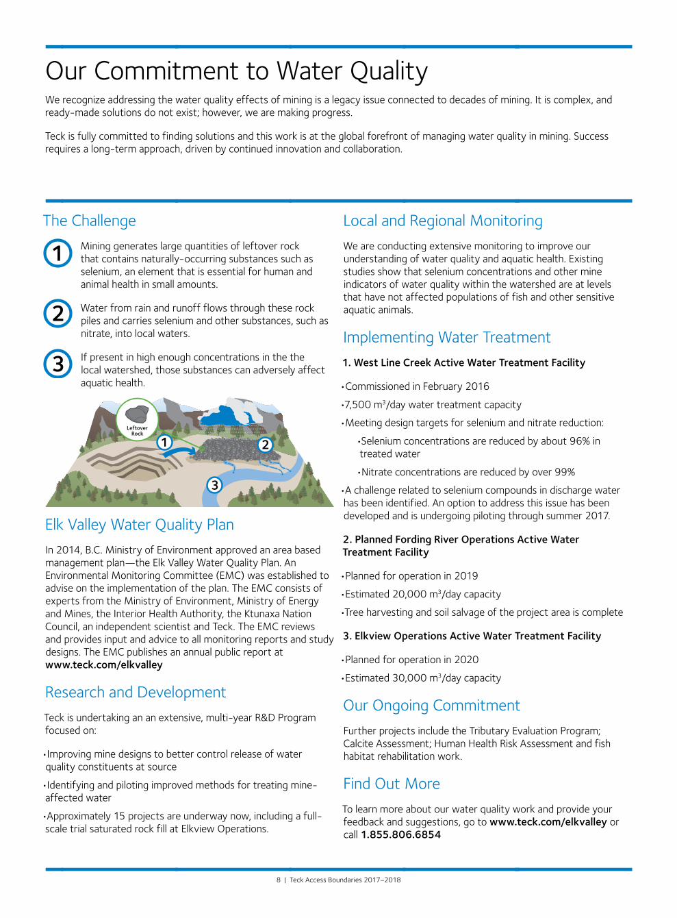
The Challenge
Mining generates large quantities of leftover rock that contains naturally-occurring substances such as selenium, an element that is essential for human and animal health in small amounts.
Water from rain and runoff flows through these rock piles and carries selenium and other substances, such as nitrate, into local waters.
If present in high enough concentrations in the the local watershed, those substances can adversely affect aquatic health.
Our Commitment to Water QualityWe recognize addressing the water quality effects of mining is a legacy issue connected to decades of mining. It is complex, and ready-made solutions do not exist; however, we are making progress.
Teck is fully committed to finding solutions and this work is at the global forefront of managing water quality in mining. Success requires a long-term approach, driven by continued innovation and collaboration.
Elk Valley Water Quality Plan
In 2014, B.C. Ministry of Environment approved an area based management plan—the Elk Valley Water Quality Plan. An Environmental Monitoring Committee (EMC) was established to advise on the implementation of the plan. The EMC consists of experts from the Ministry of Environment, Ministry of Energy and Mines, the Interior Health Authority, the Ktunaxa Nation Council, an independent scientist and Teck. The EMC reviews and provides input and advice to all monitoring reports and study designs. The EMC publishes an annual public report at www.teck.com/elkvalley
Research and Development
Teck is undertaking an an extensive, multi-year R&D Program focused on:
•Improving mine designs to better control release of water quality constituents at source
•Identifying and piloting improved methods for treating mine-affected water
•Approximately 15 projects are underway now, including a full-scale trial saturated rock fill at Elkview Operations.
Local and Regional Monitoring
We are conducting extensive monitoring to improve our understanding of water quality and aquatic health. Existing studies show that selenium concentrations and other mine indicators of water quality within the watershed are at levels that have not affected populations of fish and other sensitive aquatic animals.
Implementing Water Treatment
1. West Line Creek Active Water Treatment Facility
•Commissioned in February 2016
•7,500 m3/day water treatment capacity
•Meeting design targets for selenium and nitrate reduction:
•Selenium concentrations are reduced by about 96% in treated water
•Nitrate concentrations are reduced by over 99%
•A challenge related to selenium compounds in discharge water has been identified. An option to address this issue has been developed and is undergoing piloting through summer 2017.
2. Planned Fording River Operations Active Water Treatment Facility
•Planned for operation in 2019
•Estimated 20,000 m3/day capacity
•Tree harvesting and soil salvage of the project area is complete
3. Elkview Operations Active Water Treatment Facility
•Planned for operation in 2020
•Estimated 30,000 m3/day capacity
Our Ongoing Commitment
Further projects include the Tributary Evaluation Program; Calcite Assessment; Human Health Risk Assessment and fish habitat rehabilitation work.
Find Out More
To learn more about our water quality work and provide your feedback and suggestions, go to www.teck.com/elkvalley or call 1.855.806.6854
Top Related