
ZIRAISLAND ZIR PROJECT: ZIRA ISLAND MASTERPLAN TYPE: COMMISSION SIZE: 1.000.000 M2 CLIENT: AVROSITI...
29
Central Asia’s first carbon neutral master plan in Baku, Azerbaijan ZIRAISLAND
Transcript of ZIRAISLAND ZIR PROJECT: ZIRA ISLAND MASTERPLAN TYPE: COMMISSION SIZE: 1.000.000 M2 CLIENT: AVROSITI...

Central Asia’s first carbon neutral master plan in Baku, AzerbaijanZIRAISLAND

ZIRAISLAND

CODE: ZIRPROJECT: ZIRA ISLAND MASTERPLANTYPE: COMMISSIONSIZE: 1.000.000 M2CLIENT: AVROSITI HOLDINGARCHITECT: BIGENGINEER: RAMBOLLCOLLABORATORS: KOSAR DEMIRLOCATION: BAKU, AZERBAIJAN
CREDITS:
PARTNER IN CHARGE: BJARKE INGELSwITH ASSOCIATE PARTNER ANDREAS KLOK PEDERSEN PROJECT MANAGEMENT: KAI-UwE BERGMANN TEAM: SYLVIA FENG, KINGA RAJCZYKOwSKA, PåL ARNULF TRODAHL, PAULINE LAVIE, MAxIME ENRICO, OANA SIMIO-NESCU, ALEx COZMA, MOLLY PRICE, NIELS DAMSGAARD, DOUG A. STECHSCHULTE, ONDREJ JANKU. VISUALS: OCEANPIC LTD GRAPHIC DESIGN: ERNESTO MONCADA


2.
The Master Plan2.1 Location and Connectivity2.2 Phasing2.3 Areas and Data2.4 Diagrams
1.
The Seven Peaks of Azerbaijan1.1 The Landscape 1.2 The Skyline1.3 Zira Zero Island
4.
The Seven Peaks + The Villas
4.1 Savalan4.2 Ayidagh4.3 Ilandagh4.4 Shahdagh
4.5 Kapaz4.6 Beshbarmaq4.7 Babadagh4.8 The Villas
3.
Sustainability3.1 Zero Carbon Footprint3.2 Wind Power
5.
Information5.1 The Developer5.2 The Architect5.3 The Engineer5.4 Contact Info
P. 8
Index
P. 9
Index
InDEx

Azerbaijan has long been called “The Alps of Central Asia”. Its natural landscape continue to play an important role in present day Azerbaijan. Shaped by the Cauca-sus Range towards the north and the coastline of the Caspian Sea, Azerbaijan is a strategic gateway between east and west full of contrasts and contradictions.
The landscape of Azerbaijan includes many snow-capped peaks exceeding 4.000 meters, lush green valleys towards the south and large swathes of arid semi-desert in between. Just a few hours drive away from timeless mountain villages clad in lush orchards sits the Azerbaijani capital of Baku which in Persian means “the wind swept city” whose medieval center is a UnESCO World Heritage site and home to the Zira Island Master Plan.
1.1 THE LANDSCAPE
P. 10
Intro
P. 11
Intro

1.2 the seven peaks
Caucasus has long been called “The Alps of Central Asia”. The natural landscape continue to play an important role in present day Azerbaijan. Shaped by the Caucasus Range towards the north and the coastline of the Caspian Sea, Azerbaijan is a strategic gateway between east and west full of contrasts and contradictions.
The landscape of Azerbaijan includes many snow-capped peaks exceeding 4.000 meters, lush green valleys towards the south and large swathes of arid semi-desert in between. Just a few hours drive away from timeless mountain villages clad in lush orchards sits the Azerbaijani capital of Baku which in Persian means “the wind swept city” whose medieval center is a UnESCO World Heritage site and home to the Zira Island Master Plan.
Caucasus - The Alps of Central Asia.
P. 12
Intro
P. 13
Intro
1.2 THE SKYLINE
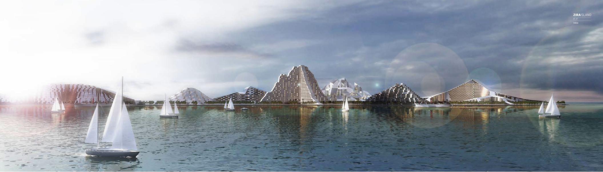
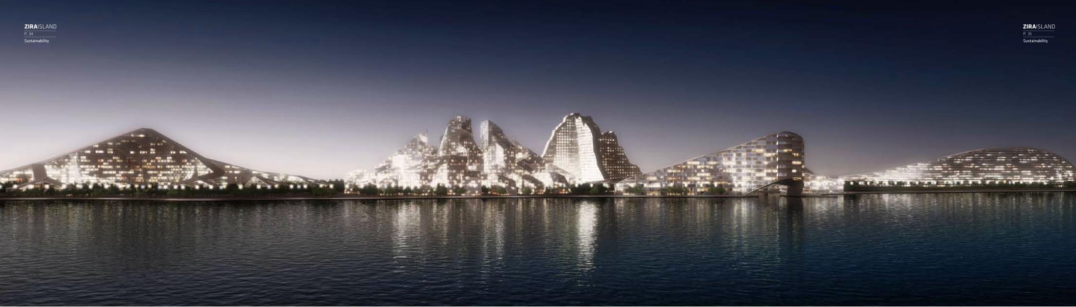
Located within the crescent shaped bay of the capital city Baku, Zira Island includes the Seven Peaks of Azerbaijan which is envisioned to be a sustainable model for urban development, and an iconographic skyline recognizable from the city’s coastline. The Seven Peaks is an architec-tural landscape based upon the country’s dramatic natural setting.
Each of the Seven Peaks house a residential mixed-use development derived from the geom-etry of a famous mountain in Azerbaijan. Individually each mountain becomes a principle for mixing private and public functions. Together the mountains form an organic skyline merging with the natural topography of the island. A dense vibrant urban community connected to a series of private resort villages by a central public valley and surrounding beaches. A continu-ous public trekking path connects the mountains and invites visitors to scale the top of all seven peaks. In addition to the Seven Peaks the Master Plan also includes 300 private villas that take advantage of their setting with panoramic views out over the Caspian Sea.
“Zira Island proposes an architectural landscape derived from the natural landscape of Azerbaijan.”

1.3 ZIRA ZERO ISLAND
“The Seven Peaks are conceived not only as icons, but engineered as entire eco-systems, a model for future sustainable urban development.”
P. 14
Intro
P. 15
Intro
The vision of Zira Island is to create an island that is entirely independent of external re-sources. A self contained island. By combining the best of the traditional Azerbaijani building tradition with the newest technology, Zira Island will provide excellent living spaces for people, with a minimum usage of resources. A showcase to the world combining high-end living with low end resource usage.
The Seven Peaks of Azerbaijan proposes an architectural landscape derived from its natural landscape. This new architecture not only recreates the iconic silhouettes of the seven peaks, but more importantly creates an autonomous ecosystem where the flow of air, water, heat and energy are channeled in almost natural ways. A mountain creates biotopes and eco-niches, it channels water and stores heat, it provides viewpoints and valleys, access and shelter. The Seven Peaks are conceived not only as icons, but engineered as entire eco-systems, a model for future sustainable urban development.
P. 16
Intro
P. 17
Intro

2.1 LOCATION AND CONNECTIVITYZira Island, formerly known as nargin, is part of the Baku Archipelago, which consists of sev-eral islands. Zira Island is the largest of these which separates the Bay of Baku from the sea south of the Absheron Peninsula. The island is visible from the entire Bay of Baku and its 3.5 million inhabitants. The island has a length of 3.1 km, and a width of 600 m. The northwestern side of the island is vertical and steep flattening out towards the south.
Zira Island will be connected to the mainland via a variety of transportation options either by water or air. The island becomes linked to the mainland by regular shuttle service which would make the circa 10 km journey at regular intervals. On the island a network of electrical cars and taxis will provide an efficient circulation, while at the same time ensuring limited traffic on the island, and the ultimate privacy and well being for its residents and visitors to the hotel and marina alike.
P. 18
Master Plan
P. 19
Master Plan
02. THE MASTER PLAn

2.2 PHASING
The master plan is conceived as a series of neighborhoods along the coastline, ranging from high density urban areas in the western part of the island to the villas areas in the eastern part. The neighborhoods are tied together by the central public park that leads to the centrally located main beach. The eastern most tip of the island is the location of three grand luxury villas with private beaches and heliport.
The Zira Island Master Plan is divided into two major phases. Phase 1 encapsulates the the Master Plan the entire island, the design and construction of the 300 private villas with their own private beach as well as the Kapaz Mountain which includes a 5 star hotel. The ferry terminal and marina adjacent to Kapaz and the landscaping for all of these elements would also be included. All ancillary developments such as ferry terminals and parking facilities on the mainland would also be planned and built during this time. Phase 2 would include the additional six mountain developments, completing the landscaping, the three luxury villas situated within 7 hectares on the northern tip of the island and the offshore windmill farm. The two phases will work independent of one another and are driven by their individual devel-opment timelines.
250 M
P. 20
Master Plan
P. 21
Master Plan

2.3 MASTERPLAN AREAS AND DATAP. 22
Master Plan
P. 23
Master Plan

INFRASTRUCTUREThe heart of the transport system of the island is the net-work of electrical cars, taxis and shuttle services utilizing the ring road along the park and creating an emission free environment. The shuttle ferry terminal connecting the is-land to the main land is centrally located at the north shore facing Baku city. Two heliports on the island provide fast connections to several locations within the capital.
PUBLIC SPACESSurrounding each of the seven peaks are a variety of attrac-tive public spaces, from dense shopping streets to vibrant promenades with restaurants and cafés. The waterfront promenade ties the different neighborhoods together, while a public trekking path invites visitors to climb all the seven peaks in a single day!
2.4 MASTERPLAN DETAILS
SERVICE HARBOUR
P. 24
Master Plan
P. 25
Master Plan

BEACHES AND MARINASThe coastline of Zira Island is dotted with marinas and beaches. The Island features three different marinas: Kapaz marina at the main port of the island including the shuttle ferry terminal, the large Sav-alan marina and the Babadagh marina surrounded by holiday apart-ments with private boat lots.A large beach in the center of the island, as well as a series of small-er lagoons along the coastline offers a variety of leisure activities in the clear waters of the Caspian Sea.
THE LANDSCAPEThe landscaping of the island is derived from wind simulations of the microclimates created by the mountains. The central park of the island will offer a lush green condition creating the atmosphere of a tropical island.Patterns created by the wind moving its way through the Seven Peaks will inform the planting of trees and the placement and de-sign of public spaces and plazas. Where the winds and turbulence are strongest the trees becomes denser, creating lower wind speeds and thus a comfortable outdoor leisure climate.
BEACHES AND MARINASThe coastline of Zira Island is dotted with marinas and beaches. The Island features three different marinas: Kapaz marina at the main port of the island including the shuttle ferry terminal, the large Savalan marina and the Babadagh marina surrounded by holiday apartments with private boat lots. A large beach in the center of the island, as well as a series of smaller lagoons along the coastline offers a variety of leisure activities in the clear waters of the Caspian Sea.
THE LANDSCAPEThe landscaping of the island is derived from wind simula-tions of the microclimates created by the mountains. The central park of the island will offer a lush green oasis creat-ing the atmosphere of a tropical island.
P. 26
Master Plan
P. 27
Master Plan

PAVEMENTTWO COLOR URBAN PAVEMENTGENERATED BY WIND SIMULATION
PAVEMENTPatterns created by the wind moving its way through the Seven Peaks will inform the planting of trees and the place-ment and design of public spaces and plazas. Where the winds and turbulence are strongest the trees becomes denser, creating lower wind speeds and thus a comfortable outdoor leisure climate.
P. 28
Master Plan
P. 29
Master Plan

OFF SHOREWIND TURBINE
DESALINATION PLANT
WASTE WATER TREATMENT
HEAT PUMP
HIGH INSULATION ARCHITECTURE
WATER COOLING / HEATING
FRESH WATER
DRINKING WATER FROM LAND
PHOTOVOLTAICSSOLAR HEAT PANELS
HOT WATER
GREY WATER
IRRIGATIONWATER
SUNThe buildings of the island are entirely heated and cooled by heat pumps connecting to the surrounding Caspian Sea. Solar heat panels integrated in the architecture create a steady supply of hot water, while photovoltaics on strategically located facades and roof tops power daytime functions as swimming pools and aqua parks.
WINDZira Island benefits from the fact that Baku is “The wind swept city”. By harvesting the wind energy through an offshore wind farm, Zira Is-land will have its own CO2-neutral power sup-ply. The wind turbines will power the entire island, transforming the platforms and founda-tions of the existing offshore oil industry and replacing the forest of oil towers in the horizon of the Caspian Sea.
WATERAll waste water and storm water is collected and led to a waste water treatment plant, where it is cleaned, processed and recycled for irrigation. The solid parts of the waste water are processed and composted and finally turned into top soil, fertilizing the island. The constant irrigation and fertilizing of the island supports the lush green condition of a tropical island, with a minimal ecological footprint.
The island deploys the three abundant resources – sun, water and wind – to achieve its zero carbon footprint. A showcase to the world combining high-end living with low-end resource usage.
3.1. ZERO CARBON FOOTPRINTP. 30
Sustainability
P. 31
Sustainability
+ +
03. SUSTAInABILITY

“... Zira Island will have its own CO2-neutral power supply by harvesting the wind energy through an offshore wind farm.”
“Transforming the platforms and foundations of the existing offshore oil industry ...”
3.2. WIND POWERP. 32
Sustainability
P. 33
Sustainability
P. 34
Sustainability
P. 35
Sustainability

HOTEL SERVICEAPARTMENTS
CONDOS ROW HOUSING BUNGALOWS
The first mountain, Savalan is conceived as a network of differ-ent programs from the hotel at the center, branching out into apartments, row houses and finally inversing into a dense street grid with shops, bars and cafés. The branches embrace a series of spaces for leisure activities, pools, sports and parks.
100 M
4.1 SAVALAN
P. 36
The Seven Peaks
P. 37
The Seven Peaks
04. The SeveN PeAKS+ The vILLAS

TERRACE HOUSING
EVENT SPACE
100 M
The Cave Mountain is designed as mountain of luxu-ry apartments with grand terraces and views to the Caspian sea. The apartments enclose a central public hall for various venues, conventions and exhibitions.
4.2 AYIDAGH
P. 38
The Seven Peaks
P. 39
The Seven Peaks

1. HEIGHT DATA 2. PHOTO PROFILE 1 3. PHOTO PROFILE 2 4. COMBINED PROFILES CREATE 3d EFFECT 5. FOUR PLAZAS
100 M
The most iconic and recognizable of the seven peaks, Ilandgagh, is mate-rialized in 3D in the simplest way possible – two silhouettes intersecting in a cross recreating the epic profile seen from all directions around the island. The building contains a luxury hotel surrounded by four plazas with pools and restaurants.
4.3 ILANDAGH
P. 40
The Seven Peaks
P. 41
The Seven Peaks

1. HEIGHT DATA 2. SMOOTH GEOMETRY 3. LAYOUT OF TERRACES 4. SHAHDAGH GEOMETRY 5. INTERIOR EVENT SPACE
100 M
The King’s Mountain is a soft silhouette perforated by square courtyards. From Google earth the mountain appears like a gi-ant chess board, an homage to Kasparov native son of Baku. The building contains apartments, offices and a grand theater hall.
4.4 SHAHDAGH
P. 42
The Seven Peaks
P. 43
The Seven Peaks

1. ISLAND TOPOGRAPHY 2. ARCH-SHAPED LAGUNA BUILDING 3. ACCES TO ROOF 4. WARPED GEOMETRY CREATES PUBLIC POCKETS
5. KAPAZ GEOMETRY
The Kapaz mountain of Zira Island recreates the iconic silhouette of the “Bridal Crown Mountain” at Goy Gol Lajke when arriving by boat. Using the structural principles of Uruguayan engineer eladio Dieste, the thin slab achieves stability by forming a sine curve at ground level. The resulting deformations create hillside terraces and covered public spaces on both sides of the mountain. It forms the main port of the island, and features a five-star hotel, a marina and a promenade with restaurants.
100 M
4.5 KAPAZ
P. 44
The Seven Peaks
P. 45
The Seven Peaks
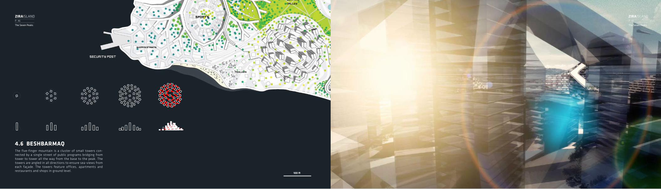
The five-finger mountain is a cluster of small towers con-nected by a single street of public programs bridging from tower to tower all the way from the base to the peak. The towers are angled in all directions to ensure sea-views from each façade. The towers feature offices, apartments and restaurants and shops in ground level.
100 M
4.6 BESHBARMAQ
P. 46
The Seven Peaks
P. 47
The Seven Peaks
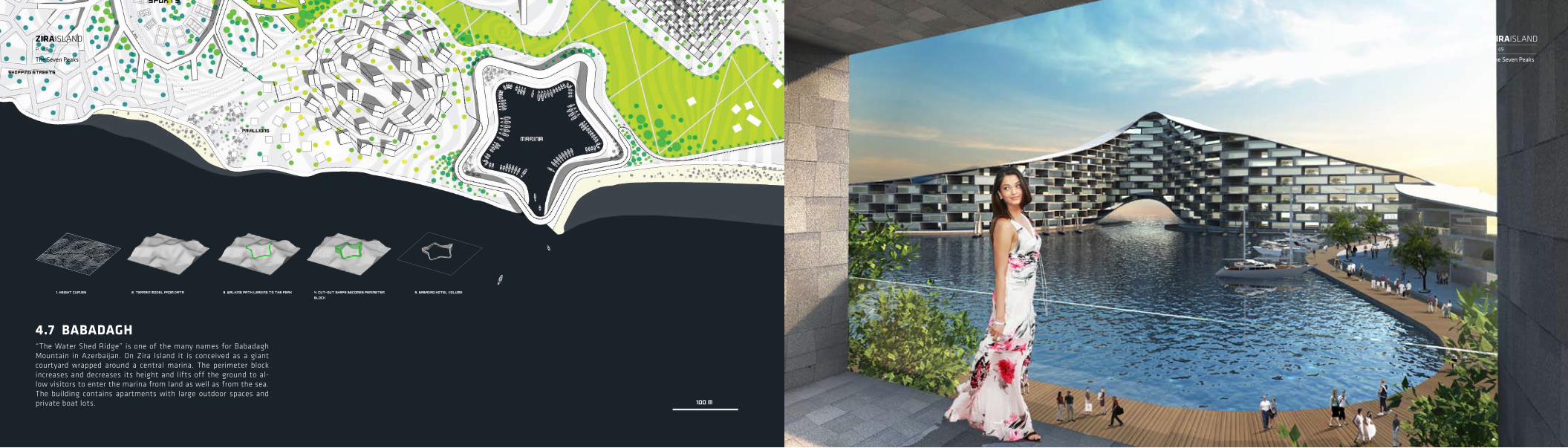
“The Water Shed Ridge” is one of the many names for Babadagh Mountain in Azerbaijan. On Zira Island it is conceived as a giant courtyard wrapped around a central marina. The perimeter block increases and decreases its height and lifts off the ground to al-low visitors to enter the marina from land as well as from the sea. The building contains apartments with large outdoor spaces and private boat lots.
1. Height curves 2. Terrain model from data 3. Walking path leading to the peak 4. Cut-out shape BECOMES PERIMETER BLOCK
5. Babadaq hotel volume
100 M
4.7 BABADAGH
P. 48
The Seven Peaks
P. 49
The Seven Peaks

Zira Island will bring a new level of luxury to Azerbaijan and is des-tined to be one of the most exclusive developments in the region with its exceptional facilities and exclusive location. The villas in-clude an exclusive residential community, a stunning lagoon, a ma-rina, and a world class spa. All of the villas will be artfully designed over multiple landscape levels, ensuring unobstructed sea and la-goon views. All villas will include water features with swimming pools and spacious sundecks. each villa is sited upon a 600 square meter site and range from 300 to 800 square meters.
250 m
4.8 THE VILLAS
P. 50
The Seven Peaks
P. 51
The Seven Peaks

Zira Island will introduce a sophisticated, elegant oasis to the heart of Central Asia, offering an exclusive hideaway for discerning international and regional patrons. The eastern tip of the island contains the 70.000 M2 site dedicated to three luxury villas each measuring 2500 M2. The villas feature private beaches, marinas and a heliport.
P. 52
The Seven Peaks
P. 53
The Seven Peaks

To learn more about the Zira Islandmaster plan please visit
www.ziraisland.com
Press and Media: [email protected]
05. INFO
The DeveLOPeRAvrositi Holding is a property development company based in Baku, Azerbaijan. Avrositi Holding was established pri-marily to create world-class real estate developments in Azerbaijan and Central Asia.
Avrositi Holding is mainly active in developing highly am-bitious residential and business complexes to premium standards. Dedicated to achieving new heights of innova-tion, excellence and value in urban design and sustainable development, Avrositi Holding hopes that its Zira Island Master Plan will set a new standard for both luxury as well as sustainable living in Baku, Azerbaijan. Avrositi Holding seeks to partner with the best of the best in luxury hospi-tality providers.
www.avrositi.com
The eNGINeeR CONTACT INFORamboll is a leading engineering, design and consultancy com-pany founded in Denmark in 1945. Today, Ramboll employs more than 8,000 ambitious experts and have a significant presence in northern Europe, India, Russia and the Middle East. With our close to 190 permanent and temporary offices in 24 countries we emphasize local expertise combined with a global knowledge-base.
Ramboll constantly strive to achieve inspiring and exacting solutions that make a genuine difference to our customers, the end-users and society as a whole. Ramboll operates within the areas of: Buildings & Design, Infrastructure & Transport, Energy & Climate, Environment & nature, Industry & Oil/Gas, IT & Telecom and Management & Society.
www.ramboll.com
The ARChITeCTBIG is a Copenhagen based group of architects, designers, builders and thinkers operating within the fields of architec-ture, urbanism, research and development. The office is cur-rently involved in a large number of projects throughout Eu-rope, the Middle East and Asia.
BIG’s architecture emerges out of a careful analysis of how contemporary life constantly evolves and changes. Like a form of programmatic alchemy BIG creates architecture by mix-ing conventional ingredients such as living, leisure, working, parking and shopping. By hitting the fertile overlap between pragmatic and utopia, BIG seeks to change the surface of our Planet, to better fit contemporary life forms.
www.big.dk
5.1 5.2 5.3 5.4
P. 54
Info
P. 55
Info

WWW.ZIRAISLAND.COM


![[XLS]indianrailways.gov.inindianrailways.gov.in/railwayboard/uploads/DATA/AKASH/I_R... · Web viewSCR ZCS ZURARI AGRO CHEMICALS SIDING NR ZPR ZORAWARPURA ZIRA ZIRA OA NER ZNP ZINDPURA](https://static.fdocuments.net/doc/165x107/5ab040717f8b9a22118e3f93/xls-viewscr-zcs-zurari-agro-chemicals-siding-nr-zpr-zorawarpura-zira-zira-oa-ner.jpg)