ZI NO. 2399 NORTHEAST HILLSIDES ZONE CHANGE …zimas.lacity.org/documents/zoneinfo/ZI2399.pdf · ZI...
17
1 CITY OF LOS ANGELES DEPARTMENT OF CITY PLANNING ZONING INFORMATION FILE Effective Date: January 16, 2009 ZI NO. 2399 NORTHEAST HILLSIDES ZONE CHANGE ORDINANCE ORDINANCE NO. 108,403 COUNCIL DISTRICT: 1 & 14 COMMENTS: The Northeast Los Angeles Hillsides Zone Change Ordinance (No. 180,403; effective date: January 16, 2009) establishes new regulations for properties in the adopted hillside area boundary in the Northeast Los Angeles Community Plan. There are approximately 11,000 properties impacted by the ordinance in the following zones: OS, A1, RE40, RE20, RE9, RS, R1, R2, RD6, RD5, RD4, RD3, RD2, RD1.5, C1, and PF. The regulations focus on size, height, retaining walls and grading limitations. INSTRUCTIONS: Vested Development Plans This ordinance does not apply to development plans submitted for plan check prior to January 16, 2009 and vested under the provisions of Section 12.26 A. 3 of the Los Angeles Municipal Code. Project For Which This Ordinance Applies Development plans submitted for plan check on or after January 16, 2009 shall be reviewed in accordance with the limitations outlined in the Northeast Los Angeles Hillsides Zone Change Ordinance (No. 180,403). A copy of the adopted ordinance is attached to this ZI. CLEARANCE INFORMATION: The following are required for submission for clearance to the Department of Public Works – Bureau of Street Services – Urban Forestry Division : A. Landscape plans with plant legend (Retaining walls and building understory areas must be shown in plan, sections/elevations and identify plantings/planting materials used for screening) B. Tree report from licensed professionals Applicants must obtain an approved Tree Report letter from the Department of Public Works – Bureau of Street Services – Urban Forestry Division in order to obtain clearance(s) from Department of City Planning. The following are required for submission for clearance to the Department of City Planning : C. One set of color photographs mounted on 8.5” x 11” cardstock or paper equivalent. It is very important to take as many pictures to illustrate the property and issues surrounding
Transcript of ZI NO. 2399 NORTHEAST HILLSIDES ZONE CHANGE …zimas.lacity.org/documents/zoneinfo/ZI2399.pdf · ZI...
1
CITY OF LOS ANGELES DEPARTMENT OF CITY PLANNING
ZONING INFORMATION FILE
Effective Date: January 16, 2009
ZI NO. 2399 NORTHEAST HILLSIDES ZONE CHANGE ORDINANCE
ORDINANCE NO. 108,403
COUNCIL DISTRICT: 1 & 14 COMMENTS: The Northeast Los Angeles Hillsides Zone Change Ordinance (No. 180,403; effective date: January 16, 2009) establishes new regulations for properties in the adopted hillside area boundary in the Northeast Los Angeles Community Plan. There are approximately 11,000 properties impacted by the ordinance in the following zones: OS, A1, RE40, RE20, RE9, RS, R1, R2, RD6, RD5, RD4, RD3, RD2, RD1.5, C1, and PF. The regulations focus on size, height, retaining walls and grading limitations. INSTRUCTIONS: Vested Development Plans This ordinance does not apply to development plans submitted for plan check prior to January 16, 2009 and vested under the provisions of Section 12.26 A. 3 of the Los Angeles Municipal Code. Project For Which This Ordinance Applies Development plans submitted for plan check on or after January 16, 2009 shall be reviewed in accordance with the limitations outlined in the Northeast Los Angeles Hillsides Zone Change Ordinance (No. 180,403). A copy of the adopted ordinance is attached to this ZI. CLEARANCE INFORMATION: The following are required for submission for clearance to the Department of Public Works – Bureau of Street Services – Urban Forestry Division:
A. Landscape plans with plant legend (Retaining walls and building understory areas must
be shown in plan, sections/elevations and identify plantings/planting materials used for screening)
B. Tree report from licensed professionals Applicants must obtain an approved Tree Report letter from the Department of Public Works – Bureau of Street Services – Urban Forestry Division in order to obtain clearance(s) from Department of City Planning.
The following are required for submission for clearance to the Department of City Planning:
C. One set of color photographs mounted on 8.5” x 11” cardstock or paper equivalent. It is
very important to take as many pictures to illustrate the property and issues surrounding
2
the property. They should include pictures of every lot for a distance of 200 feet, with an index map indicating where the photographs were taken.
D. Complete Architectural Drawings (See H below for details). E. Samples of all exterior building materials and colors with manufacturer's specifications
sheets and/or brochures. F. For projects with new construction that is in substantial compliance with the
requirements for the U.S. Green Building Council’s (USGBC) Leadership in Energy and Environmental Design (LEED®) for Homes program at the “Certified” level or higher, the applicant shall provide:
(1) Completed U.S. Green Building Council’s (USGBC) Leadership in Energy and Environmental Design (LEED©) Project Registration Form; (2) Receipt or other proof of payment issued by the USGBC; (3) Completed the LEED© for Homes Project Checklist (prepared by USGBC-contracted LEED© for Homes Provider); (4) Signed declaration from the USGBC-contracted LEED© for Homes Provider; and, (5) Complete set of plans with:
o each sheet stamped and signed by a licensed architect or engineer; o each sheet stamped and signed by the USGBC-contracted LEED© for Homes
Provider; o copy of LEED© for Homes Project Checklist on plan sheets; o copy of signed declaration from the USGBC-contracted LEED© for Homes
Provider on plan sheets; and o measures being provided for LEED© Certification clearly identified and indicated
For more information on LEED© for Homes Program, as well as copies of the LEED© forms mentioned above please go to the USGBC’s website (www.usgbc.org). If changes are made to the project, the applicant shall be required to submit a revised set of plans, including the four requirements listed above, with all revisions necessary to make the project in substantial compliance with the requirements for LEED® Certification.
G. Approved Tree Report letter from Dept of Public Works – Bureau Of Street Services - Urban Forestry Division.
PLAN SUBMITTAL - REQUIRED MATERIALS TO BE SUBMITTED TO LADBS:
H. Complete Architectural Drawings (one full size set - stapled and edge bound & one 11”x17”) with respective professional license stamp(s) and accurate date, including, but not limited to having the following:
1. Site plan at a minimum of 1/8 inch scale, fully dimensioned 2. Grading plan showing new and existing 1-foot contour intervals
3
3. Site survey by a licensed surveyor showing project boundaries and 1-foot contour intervals
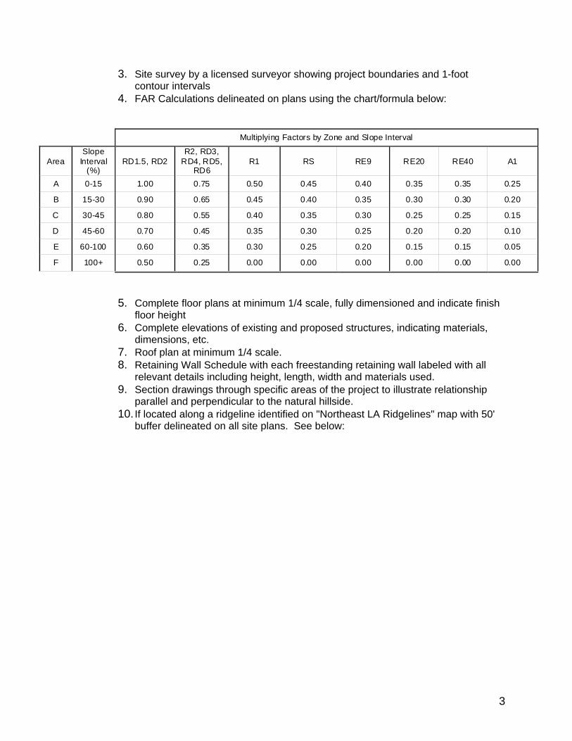
4. FAR Calculations delineated on plans using the chart/formula below:
5. Complete floor plans at minimum 1/4 scale, fully dimensioned and indicate finish
floor height 6. Complete elevations of existing and proposed structures, indicating materials,
dimensions, etc. 7. Roof plan at minimum 1/4 scale. 8. Retaining Wall Schedule with each freestanding retaining wall labeled with all
relevant details including height, length, width and materials used. 9. Section drawings through specific areas of the project to illustrate relationship
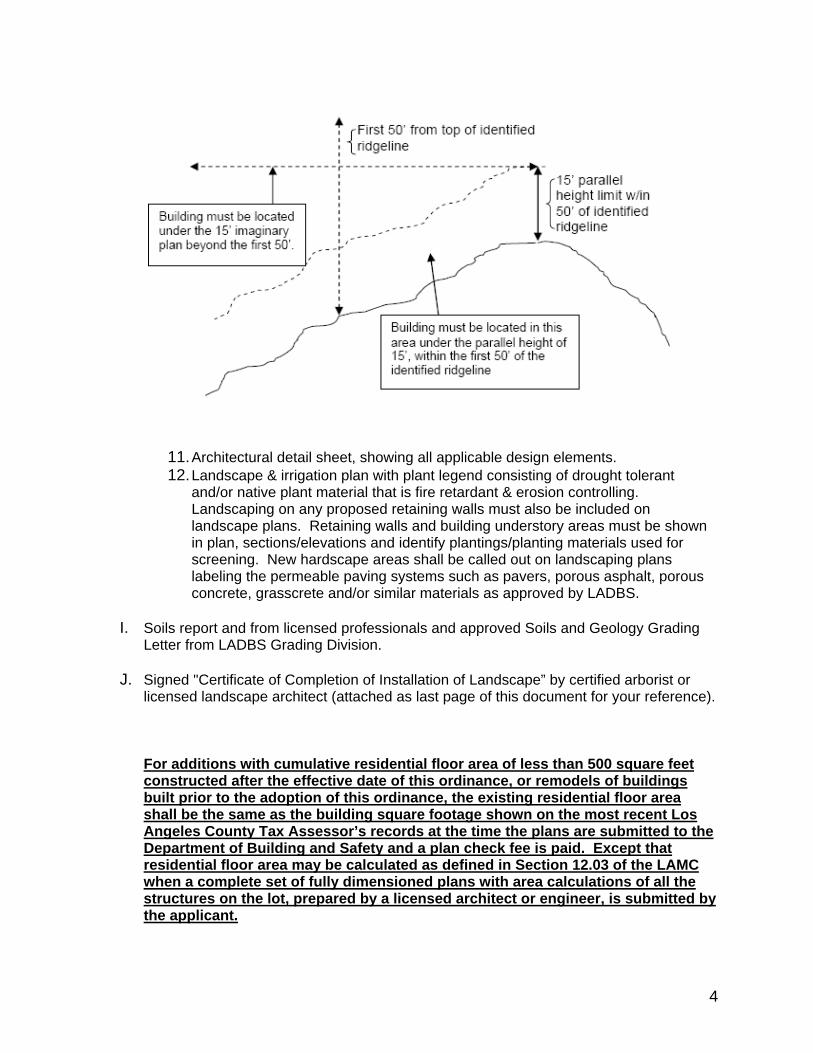
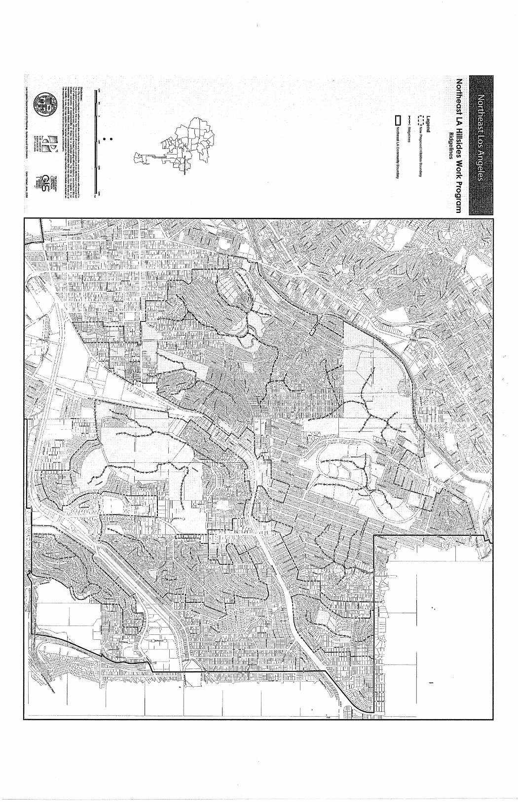
parallel and perpendicular to the natural hillside. 10. If located along a ridgeline identified on "Northeast LA Ridgelines" map with 50'
buffer delineated on all site plans. See below:
Multiplying Factors by Zone and Slope Interval
Area Slope
Interval (%)
RD1.5, RD2 R2, RD3,
RD4, RD5, RD6
R1 RS RE9 RE20 RE40 A1
A 0-15 1.00 0.75 0.50 0.45 0.40 0.35 0.35 0.25
B 15-30 0.90 0.65 0.45 0.40 0.35 0.30 0.30 0.20
C 30-45 0.80 0.55 0.40 0.35 0.30 0.25 0.25 0.15
D 45-60 0.70 0.45 0.35 0.30 0.25 0.20 0.20 0.10
E 60-100 0.60 0.35 0.30 0.25 0.20 0.15 0.15 0.05
F 100+ 0.50 0.25 0.00 0.00 0.00 0.00 0.00 0.00
4
11. Architectural detail sheet, showing all applicable design elements. 12. Landscape & irrigation plan with plant legend consisting of drought tolerant
and/or native plant material that is fire retardant & erosion controlling. Landscaping on any proposed retaining walls must also be included on landscape plans. Retaining walls and building understory areas must be shown in plan, sections/elevations and identify plantings/planting materials used for screening. New hardscape areas shall be called out on landscaping plans labeling the permeable paving systems such as pavers, porous asphalt, porous concrete, grasscrete and/or similar materials as approved by LADBS.
I. Soils report and from licensed professionals and approved Soils and Geology Grading
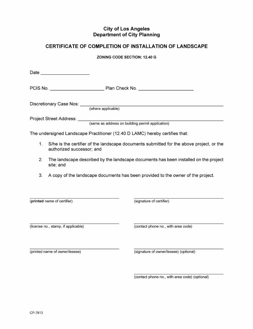
Letter from LADBS Grading Division. J. Signed "Certificate of Completion of Installation of Landscape” by certified arborist or
licensed landscape architect (attached as last page of this document for your reference).
For additions with cumulative residential floor area of less than 500 square feet constructed after the effective date of this ordinance, or remodels of buildings built prior to the adoption of this ordinance, the existing residential floor area shall be the same as the building square footage shown on the most recent Los Angeles County Tax Assessor’s records at the time the plans are submitted to the Department of Building and Safety and a plan check fee is paid. Except that residential floor area may be calculated as defined in Section 12.03 of the LAMC when a complete set of fully dimensioned plans with area calculations of all the structures on the lot, prepared by a licensed architect or engineer, is submitted by the applicant.
5
Any work that does not qualify as a remodel, as defined in the paragraph below, or additions that are 500 square feet or larger shall require a complete set of fully dimensioned plans with area calculations of all the structures on the lot prepared by a licensed architect or engineer. For the purposes of implementing this subdivision, a remodel shall mean the alteration of an existing building or structure provided that at least 50 percent of the perimeter length of the contiguous exterior walls and 50 percent of the roof are retained.
In addition to those [Q] Conditions listed in this ordinance, the [Q] Conditions pursuant to Ordinances 166,216, 166,267, 179,344 shall be retained. EXCEPTIONS: Clarifications of these Permanent “Q” Qualified Classifications should be processed through Zoning Administrator Adjustments, pursuant to Section 12.28 of the Los Angeles Municipal Code, whereby up to twenty percent increases in height and up to ten percent increases in residential floor area may be requested. Any work that does not qualify as a remodel, as defined in the paragraph below, or additions that are 500 square feet or larger shall require a complete set of fully dimensioned plans with area calculations of all the structures on the lot prepared by a licensed architect or engineer.
For the purposes of implementing this subdivision, a remodel shall mean the alteration of an existing building or structure provided that at least 50 percent of the perimeter length of the contiguous exterior walls and 50 percent of the roof are retained. If you have any questions regarding this matter, please contact the Community Planning Bureau, Northeast Unit staff at (213) 978-1168.
CPC-2008-1182-ZC Page 1
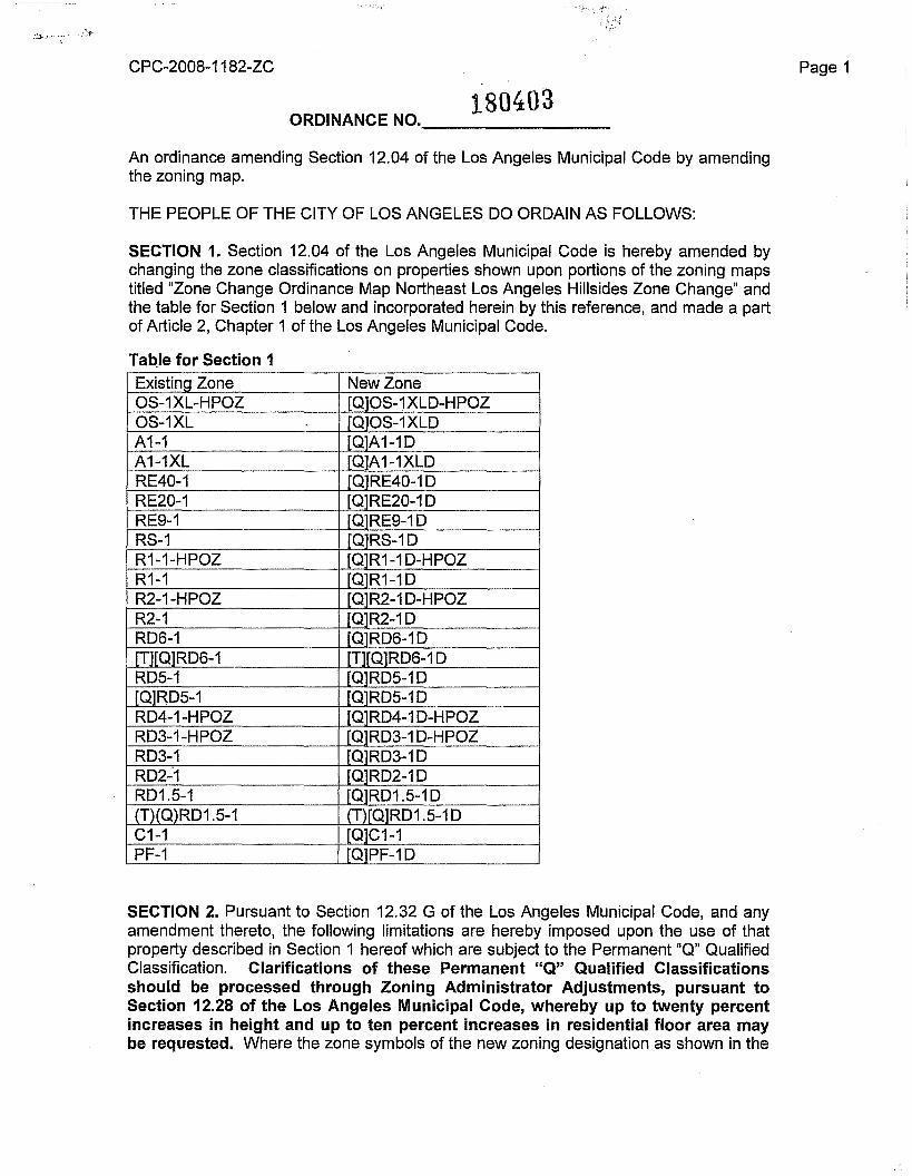
180403ORDINANCE NO. _
An ordinance amending Section 12.04 of the Los Angeles Municipal Code by amendingthe zoning map.
THE PEOPLE OF THE CITY OF LOS ANGELES DO ORDAIN AS FOLLOWS:
SECTION 1. Section 12.04 of the Los Angeles Municipal Code is hereby amended bychanging the zone classifications on properties shown upon portions of the zoning mapstitled "Zone Change Ordinance Map Northeast Los Angeles Hillsides Zone Change" andthe table for Section 1 below and incorporated herein by this reference, and made a partof Article 2, Chapter 1 of the Los Angeles Municipal Code.
Table for Section 1Existing Zone New ZoneOS-1XL-HPOZ Q OS-1XLD-HPOZOS-1XL Q OS-1XLDA1-1 Q A1-1DA1-1XL Q A1-1XLDRE40-1 Q RE40-1DRE20-1 Q RE20-1DRE9-1 Q RE9-1DRS-1 Q RS-1DR1-1-HPOZ Q R1-1D-HPOZR1-1 Q R1-1DR2-1-HPOZ Q R2-1D-HPOZR2-1 Q R2-1DRD6-1 Q RD6-1D[T][Q]RD6-1 T Q1RD6-1DRD5-1 Q RD5-1D[Q]RD5-1 Q RD5-1DRD4-1-HPOZ Q RD4-1D-HPOZRD3-1-HPOZ Q RD3-1D-HPOZRD3-1 Q RD3-1DRD2':1 Q RD2-1DRD1.5-1 Q RD1.5-1D(T)(Q)RD1.5-1 T Q]RD1.5-1DC1-1 Q C1-1PF-1 Q PF-1D
SECTION 2. Pursuant to Section 12.32 G of the Los Angeles Municipal Code, and anyamendment thereto, the following limitations are hereby imposed upon the use of thatproperty described in Section 1 hereof which are subject to the Permanent "Q" QualifiedClassification. Clarifications of these Permanent "Q" Qualified Classificationsshould be processed through Zoning Administrator Adjustments, pursuant toSection 12.28 of the Los Angeles Municipal Code, whereby up to twenty percentincreases in height and up to ten percent increases in residential floor area maybe requested. Where the zone symbols of the new zoning designation as shown in the
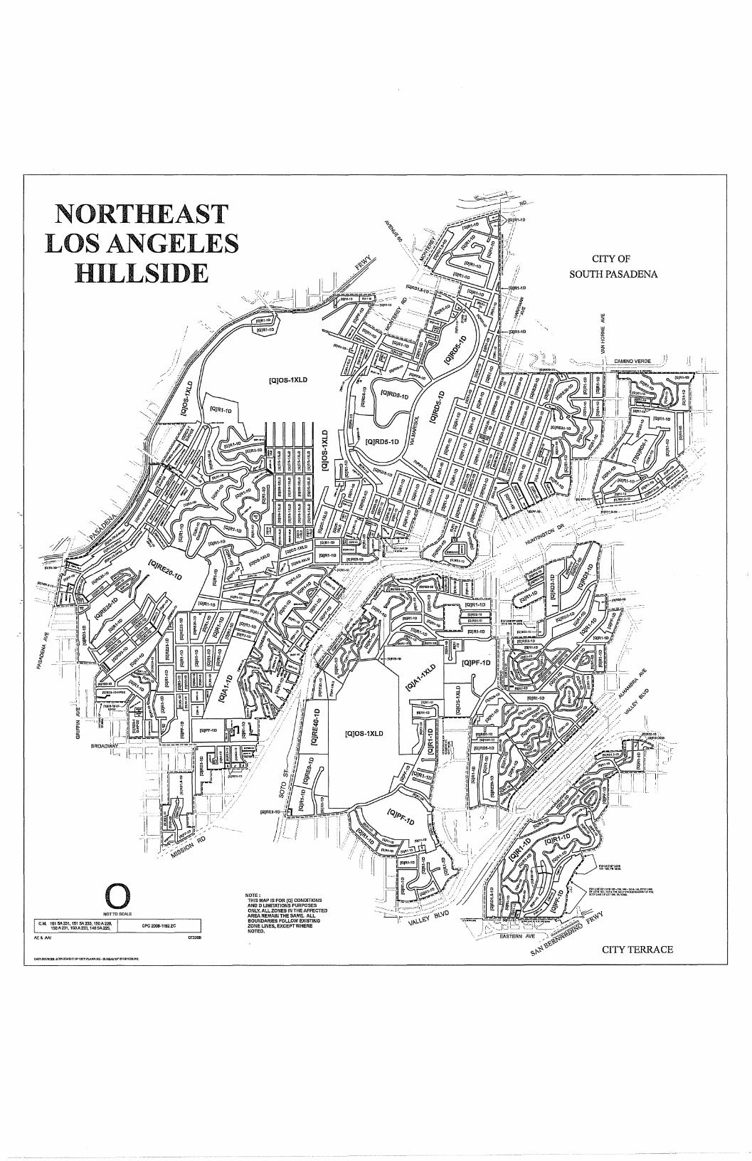
NORTHEASTLOS ANGELES
HILLSIDECITY OF
SOUTH PASADENA
UJ1(UJ
~Z
[QjOS·1XLDF=~~-~~·~:~"~-·
I
[QjOS.1XLD
o NOTE:THIS MAP IS FOR [QJ CONDmONsAND D UMITATIONS PURPOSESONLY. ALL ZONES IN THE AFFECTEDAREA REMAIN THE SAME. ALLBOUNDARIES FOLLOW EXISTINGZONE UNES, EXCEPT WHERENOTED.
NOTTOSCALE
C.M. 151 5A231. 151 51\233, 150A229,150A231, 150 A 233. 1485A225, CPC2008-1182ZC
"""ANCITY TERRACE
-"'a ~ '-"'0
iiiill"'"!J n9i9~~W~~H~nh!{i1r-hi Hi 0 I I-I r-
HJ lil :I: :-: ~F 'i~,~~ihaz '" z =
~~UI ~g: ~ Co
'T,"i • • !1!. -c
~ ~IiUI!l. ~. a
~\Jf]
~ , A l~~~I~1s:: [o0 :r:
~n1t3 ~~ c:
~~i'HIs ~
i li '" l5'
II ij9tl!i g §
I ~m~~nU~ [ il. g~glil& ~'!i '1Jh iI.,p-~H~ 9!P.~&ii i i
CPC-2008-1182-ZC Page 2
table for Section 1, are preceded by the symbol "Q" in brackets, the conditions andlimitations imposed by the new "Q" Qualified Classification are set forth as follows:
A. All properties located within the Zone Change Ordinance Map shall be subjectto the following [Q] Conditions:
1. Infrastructure
a. Construction materials and equipment shall not be permitted to be stored inthe public right-of-way in any manner that reduces roadway clearance to lessthan 20-feet in width. Storage of construction materials and equipment onpublic property requires a street use permit from the Bureau of StreetServices.
b. Construction vehicles shall be subject to the restrictions established by theLos Angeles Fire Department Red Flag - No Parking Program. Restrictedparking signs shall be procured and installed along the project site at theowner/developer's expense when required by the LAFD and/or LADOT.
2. Building Design
a. Second story setbacks or terraced structures and other design articulationsare to be used to ensure that new development is compatible with existingneighborhood identity, character and scale.
b. Building materials match architectural style of new development.
c. Architectural design elements of the front and rear building elevationsincluding articulation of facades, modulations of walls, shape, type details andthe location of windows, doors, columns, balconies and garage doors varyfrom the adjacent/abutting buildings.
d. Design of new structures shall meet one of the following standards:
(1) The total residential floor area of each story other than the base floorin a multi-story building does not exceed 75 percent of the base floorarea, where "Base Floor" and "Floor Area, Residential" shall bedefined as set forth in Section 12.03 of the Los Angeles MunicipalCode for the purposes of this regulation; or
(2) The cumulative length of the exterior walls facing the front lot line,equal to a minimum of 25 percent of the building width shall bestepped-back a distance of at least 20 percent of the building depthfrom a plane parallel to the lot width established at the point of thebuilding closest to the front lot line. When the front lot line is notstraight, a line connecting the points where the side lot lines and thefront lot line intersect shall be used. When through-lots have twofront yards, the step-back shall be provided along both front lot lines;or
CPC-2008-1182-ZC
(3) The buildings of the project shall consist of 3 or more buildingelements, each with its own associated roof form. A building elementmay also be a major horizontal mass, setback, or forward from theface of other masses.
e. Structures within 50 linear feet of identified ridgelines, as shown on attachedmap marked 'Northeast LA Ridgelines', are limited to one story or 15 feet inheight. The 50 linear feet must be labeled on all plans accordingly. Nostructure shall exceed a height in excess of 15 feet above the identifiedridgeline. The precise ridgelines shall be verified and identified on therequired topographic survey, prepared by a licensed surveyor.
f. New hardscape areas, not including foundations, shall utilize permeablepaving systems including, but not limited to pavers, porous asphalt, porousconcrete, grasscrete and/or similar materials as approved by LADBS.
3. Retaining Walls
a. The maximum total height of all freestanding retaining walls shall not exceed12 feet, with no individual wall measuring higher than 6 feet on privateproperty. Each freestanding retaining wall shall not exceed 75 feet in linearlength, nor extend beyond one lot. Walls shall be separated by a minimumhorizontal distance equal to the height of the highest wall. Freestandinggarden walls 36" in height or less shall not be considered retaining walls forthe purposes of this regulation.
b. Require that all retaining walls provide a standard surface backdrain systemand all drainage shall be conducted to the street in a non-erosive device, asrequired by approved Soils Report.
4. Landscaping
a. Landscaping palette for required landscape plans shall be comprised ofdrought tolerant and/or native plant material that is fire retardant and controlserosion.
b. Retaining walls and building understory areas shall be fully screened withplantings in a reasonable amount of time, as shown on approved landscapeplan
c. Landscape plans must be submitted to Bureau of Street Services UrbanForestry Division prior to DCP clearance. Upon satisfaction of therequirements set forth under LAMC Ordinance No. 177,404 (Protected Trees)deemed necessary by the Urban Forestry Division, an approval letter will beissued by the Urban Forestry Division and submitted with new developmentfilings as part of submission packages.
Page 3

CPC-2008-1182-ZC
d. Landscaping plans must be submitted to Bureau of Street Services, UrbanForestry Division, and Department of City Planning for review and approvalconsistent with LAMC Ordinance No. 177,404 (Protected Trees).
e. A signed "Certified Arborist's or Licensed Landscape Architect's Certificate ofCompliance" must be filed with the Department of Building & Safety prior toissuance of a "Certificate of Compliance" to ensure that landscaping plansare fully implemented.
5. Environmental
a. A Geotechnical Investigation Report that evaluates the proposed project's soiland grading shall be submitted to the LADBS Grading Division for review. Anapproved Soils & Grading report letter from LADBS - Grading Division shallbe required prior to approval of a grading, foundation or building permit.
b. Grading shall be done in accordance with the Planning Guidelines LandformGrading Manual adopted by the City Council.
c. All new graded slopes shall be no steeper than 2:1 (rise:run), except whenthe Grading Division has determined that slopes may exceed 2: 1 as part ofan approved Soils Report.
d. Grading shall be limited to a maximum of 500 cubic yards + numeric valueequal to 5 percent of the total lot size, up to a maximum of 1,000 cubic yardstotal. Any deviations beyond these limits shall require a ZoningAdministrator's approval under LAMC §12.27.
e. New hardscape areas, not including foundations, shall utilized permeablepaving systems including, but not limited to pavers, porous asphalt, porousconcrete, grasscrete and/or similar materials as approved by LADBS.
B. In addition to those [Q] Conditions listed under Section 2A, the [Q] Conditionspursuant to Ordinances 166,216, 166,267, 179,344 shall be retained.
Page 4

CPC-2008-1182-ZC Page 5
SECTION 3. Pursuant to Section 12.32 G of the Los Angeles Municipal Code, and anyamendment thereto, the following limitations are hereby imposed upon the use of thatproperty described in Section 1 hereof which are subject to the Permanent "0"Development Limitations. Where the zone symbols of the new zoning designation asshown in the table for Section 1, are followed by the symbol "0" in the suffix, theconditions and limitations imposed by the new "0" Development Limitation are set forthas follows:
A. All properties located within the Zone Change Ordinance Map shall be subjectto the following [0] Development Limitations:
1. Height
a. In addition to the height limitations contained in LAMC Section 12.21 A17(c),no building or structure shall exceed 30 feet in height from adjacent finishedgrade, measured as the vertical distance from the adjacent finished grade ofthe site to an imaginary plane located above and parallel to the finishedgrade; except that when the roof of the uppermost story of a building orstructure or portion of the building or structure has a slope of less than 25percent, the maximum height shall be 26 feet above adjacent finished grade.
b. The finished floor elevation directly above an exposed underfloor area shallbe limited to 6 feet above finished grade.
c. Attached decks shall be limited such that no portion of the walking surface ofa deck with visible underpinnings shall exceed a height of 6' above grade anddecks shall be integrated into the architecture of the house, and not appearas an add-on to the primary building mass.
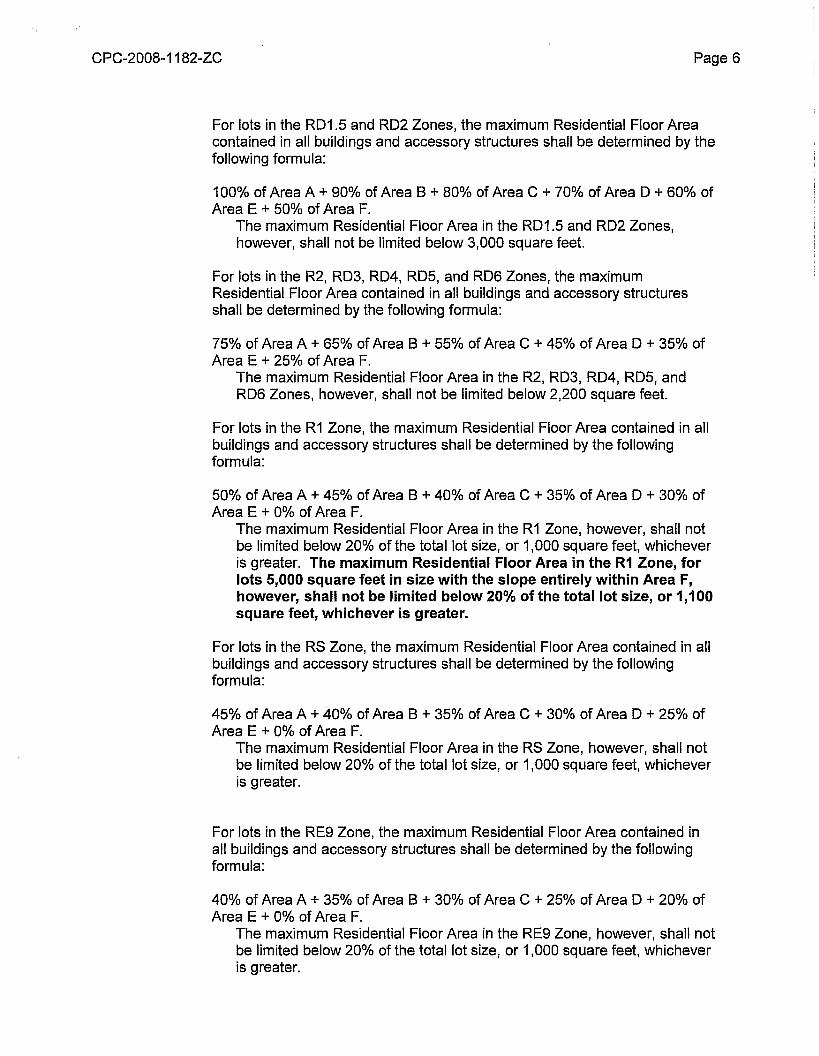
2. Maximum Residential Floor Area
Residential Floor Area for all lots shall be calculated as defined in Section 12.03of the Los Angeles Municipal Code. Consistent with the definition containedtherein, the first 400 square feet of covered parking area shall not be countedtowards the maximum Residential Floor Area. In order to calculate the maximumResidential Floor Area permitted, a site survey showing 1-foot contours must beprepared by a licensed surveyor. The survey shall identify the total area of thelot, in square feet, according to the following slope intervals:
Area A - Slope less than 15 percent;Area B - Slope at least 15 percent, but less than 30 percent;Area C - Slope at least 30 percent, but less than 45 percent;Area 0 - Slope at least 45 percent, but less than 60 percent;Area E - Slope at least 60 percent, but less than 100 percent;Area F - Slope greater than 100 percent.
CPC-200B-11B2-ZC Page 6
For lots in the RD1.5 and RD2 Zones, the maximum Residential Floor Areacontained in all buildings and accessory structures shall be determined by thefollowing formula:
100% of Area A + 90% of Area B + BO% of Area C + 70% of Area D + 60% ofArea E + 50% of Area F.
The maximum Residential Floor Area in the RD1.5 and RD2 Zones,however, shall not be limited below 3,000 square feet.
For lots in the R2, RD3, RD4, RD5, and RD6 Zones, the maximumResidential Floor Area contained in all buildings and accessory structuresshall be determined by the following formula:
75% of Area A + 65% of Area B + 55% of Area C + 45% of Area D + 35% ofArea E + 25% of Area F.
The maximum Residential Floor Area in the R2, RD3, RD4, RD5, andRD6 Zones, however, shall not be limited below 2,200 square feet.
For lots in the R1 Zone, the maximum Residential Floor Area contained in allbuildings and accessory structures shall be determined by the followingformula:
50% of Area A + 45% of Area B + 40% of Area C + 35% of Area D + 30% ofArea E + 0% of Area F.
The maximum Residential Floor Area in the R1 Zone, however, shall notbe limited below 20% of the total lot size, or 1,000 square feet, whicheveris greater. The maximum Residential Floor Area in the R1 Zone, forlots 5,000 square feet in size with the slope entirely within Area F,however, shall not be limited below 20% of the total lot size, or 1,100square feet, whichever is greater.
For lots in the RS Zone, the maximum Residential Floor Area contained in allbuildings and accessory structures shall be determined by the followingformula:
45% of Area A + 40% of Area B + 35% of Area C + 30% of Area D + 25% ofArea E + 0% of Area F.
The maximum Residential Floor Area in the RS Zone, however, shall notbe limited below 20% of the total lot size, or 1,000 square feet, whicheveris greater.
For lots in the RE9 Zone, the maximum Residential Floor Area contained inall buildings and accessory structures shall be determined by the followingformula:
40% of Area A + 35% of Area B + 30% of Area C + 25% of Area D + 20% ofArea E + 0% of Area F.
The maximum Residential Floor Area in the RE9 Zone, however, shall notbe limited below 20% of the total lot size, or 1,000 square feet, whicheveris greater.
CPC-2008-1182-ZC Page 7
For lots in the RE20 Zone, the maximum Residential Floor Area contained inall buildings and accessory structures shall be determined by the followingformula:
35% of Area A + 30% of Area B + 25% of Area C + 20% of Area D + 15% ofArea E + 0% of Area F.
The maximum Residential Floor Area in the RE20 Zone, however, shallnot be limited below 20% of the total lot size, or 1,000 square feet,whichever is greater.
For lots in the RE40 Zone, the maximum Residential Floor Area contained inall buildings and accessory structures shall be determined by the followingformula:
35% of Area A + 30% of Area B + 25% of Area C + 20% of Area D + 15% ofArea E + 0% of Area F.
The maximum Residential Floor Area in the RE40 Zone, however, shallnot be limited below 20% of the total lot size, or 1,000 square feet,whichever is greater.
For lots in the A 1 Zone, the maximum Residential Floor Area contained in allbuildings and accessory structures shall be determined by the followingformula:
25% of Area A + 20% of Area B + 15% of Area C + 10% of Area D + 5% ofArea E + 0% of Area F.
The maximum Residential Floor Area in the A 1 Zone, however, shall notbe limited below 20% of the total lot size, or 1,000 square feet, whicheveris greater.
For lots in the R1, RS, RE9, RE20, or RE40 Zone, if no portion of a lotexceeds a slope of 15 percent, an additional 20% of the maximumResidential Floor Area for that lot shall be allowed, consistent with Ordinance179,883, effective June 29, 2008. Only one 20% bonus per property isallowed.
3. Residential Floor Area Bonus For Buildings Eligible for LEED® Certification
For lots in any Zone with a portion of the lot exceeding a slope of 15 percent,which are ineligible to receive the above 20% bonus in Residential FloorArea, an additional 20% of the maximum Residential Floor Area for that lotshall be allowed for the following:
New single family dwelling construction only, if the new construction is insubstantial compliance with the requirements for the U.S. Green BuildingCouncil's (USGBC) Leadership in Energy and Environmental Design(LEED®) for Homes program at the "Certified" level or higher.
Prior to submitting an application to the Department of Building andSafety for a building permit, the applicant shall be required to obtain an
CPC-2008-1182-ZC Page 8
(1) Documentation that the project has been registered with the USGBC'sLEED® for Homes Program, and that the required fees have been paid;
authorization to submit for plan check from the Department of Planning. Inorder to obtain this authorization, the applicant shall provide:
(2) A preliminary checklist from a USGBC-contracted LEED® for HomesProvider, which demonstrates that the project can be registered with theLEED® for Homes Program with a target of certification at the "Certified"or higher level;
(3) A signed declaration from the USGBC-contracted LEED® for HomesProvider stating that the plans and plan details have been reviewed, andconfirms that the project can be registered with the LEED® for HomesProgram with a target certification at the "Certified" or higher level; and
(4) A complete set of plans stamped and signed by a licensed architect orengineer that include a copy of the preliminary checklist and signeddeclaration identified in Subparagraphs (2) and (3) of this paragraph andidentify the measures being provided for LEED® Certification. Each plansheet must also be signed by a USGBC-contracted LEED® for HomesProvider verifying that the plans are consistent with the submittedpreliminary checklist.
The Department of Building and Safety shall refer applicants to theDepartment of Planning prior to issuance of a building permit to obtain aclearance to verify the project compliance with the originally approvedplans.
If changes are made to the project, the applicant shall be required tosubmit a revised set of plans, including the four requirements listedabove, with all revisions necessary to make the project in substantialcompliance with the requirements for LEED® Certification."
4. Verification of Existing Residential Floor Area
For additions with cumulative residential floor area of less than 500 square feetconstructed after the adoption of this ordinance, or remodels of buildings built prior tothe adoption of this ordinance, the existing residential floor area shall be the same asthe building square footage shown on the most recent Los Angeles County TaxAssessor's records at the time the plans are submitted to the Department of Buildingand Safety and a plan check fee is paid. Except that residential floor area may becalculated as defined in Section 12.03 of this Code when a complete set of fullydimensioned plans with area calculations of all the structures on the lot, prepared bya licensed architect or engineer, is submitted by the applicant.
Any work that does not qualify as a remodel, as defined in the paragraph below, oradditions that are 500 square feet or larger shall require a complete set of fullydimensioned plans with area calculations of all the structures on the lot prepared bya licensed architect or engineer.
CPC-2008-1182-ZC Page 9
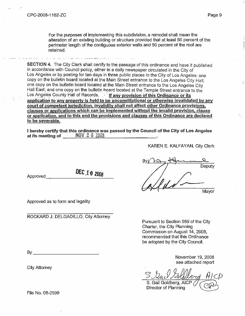
For the purposes of implementing this subdivision, a remodel shall mean thealteration of an existing building or structure provided that at least 50 percent of theperimeter length of the contiguous exterior walls and 50 percent of the roof areretained.
SECTION 4. The City Clerk shall certify to the passage of this ordinance and have it publishedin accordance with Council policy, either in a daily newspaper circulated in the City ofLos Angeles or by posting for ten days in three public places in the City of Los Angeles: onecopy on the bulletin board located at the Main Street entrance to the Los Angeles City Hall;one copy on the bulletin board located at the Main Street entrance to the Los Angeles CityHall East; and one copy on the bulletin board located at the Temple Street entrance to theLo~~~~~le_s<?_ountyHall of Records.• : -.If any provision oHhlsOrdinallce or Itsapplication to any property is held to De unconstitutional or otherwise invalidated by anycourt of competent jurisdiction, invalidity shall not affect other Ordinance provisions,clauses or applications which can-be implemented without the invalid provision, clauseor application, and to this end the provisions and clauses of this Ordinance are declaredto be severable.
I hereby certify that this ordinance was passed by the Council of the City of Los Angelesat its meeting of NOV 2 6 2008 .
KAREN E. KALFAYAN, City Clerk
VEC,l'O Z008Approved _
Deputy
Mayor
Approved as to form and legality
ROCKARD J. DELGADILLO, City AttorneyPursuant to Section 559 of the CityCharter, the City PlanningCommission on August 14, 2008,recommended that this Ordinancebe adopted by the City Council.
By __November 19, 2008see attached report
City Attorney
S. Gail Goldberg, AICP (;Director of Planning
File No. 08-2599