Yuba County Water Agency - ycwa-relicensing.com Studies/Study 07-13 - Fish... · Yuba County Water...
32
Transcript of Yuba County Water Agency - ycwa-relicensing.com Studies/Study 07-13 - Fish... · Yuba County Water...


Yuba County Water Agency Yuba River Development Project
FERC Project No. 2246
May 2013 FERC New Study Partial Bypass Fish Stranding ©2012, Yuba County Water Agency Page 1 of 14
Study 7.13
FISH STRANDING ASSOCIATED WITH SHUTDOWN OF
NARROWS 2 POWERHOUSE PARTIAL BYPASS May 2013
1.0 Project Nexus Yuba County Water Agency’s (Licensee or YCWA) continued operation and maintenance (O&M) of the Yuba River Development Project (Project) has the potential to affect resident and anadromous salmonid fish species in the Yuba River near the Project’s Narrows 2 Powerhouse by stranding fish. The powerhouse is located approximately 400 feet (ft) downstream of the United States Army Corps of Engineers’ (USACE) Englebright Dam.1 While this study examines stranding of all fish species, it focuses on Central Valley spring-run Chinook salmon (Oncorhynchus tshawytscha), Central Valley steelhead (O. mykiss), and Central Valley fall-run Chinook salmon (O. tshawytscha). Spring-run Chinook salmon and steelhead are listed as threatened under the federal Endangered Species Act (ESA). Fall-run Chinook salmon is listed as a federal species of concern by the United States Department of Commerce, National Oceanic and Atmospheric Administration, National Marine Fisheries Service (NMFS).
2.0 Resource Management Goals of Agencies with Jurisdiction Over the Resource to be Studied
YCWA believes that four agencies have jurisdiction over fish that could be potentially affected in the geographic area included in this study proposal: 1) United States Department of Interior, Fish and Wildlife Service (USFWS); 2) NMFS; 3) California Department of Fish and Wildlife (CDFW);2 and 4) State Water Resources Control Board, Division of Water Rights (SWRCB). Each of these agencies and their jurisdiction and management direction, as understood by YCWA at this time, is discussed below.
1 Englebright Dam was constructed by the California Debris Commission in 1941; is owned, operated and maintained by the
USACE; and is not included as a Project facility in FERC licenses for the Yuba River Development Project. Englebright Reservoir is formed by Englebright Dam. The dam is about 260 feet high; was constructed by the California Debris Commission in 1941; is owned by the United States; and the dam, reservoir and associated recreation facilities are not included as Project facilities in FERC’s license for the Yuba River Development Project. When the California Debris Commission was decommissioned in 1986, administration of Englebright Dam and Reservoir passed to the USACE. The primary purpose of the dam is to trap and contain sediment derived from extensive historic hydraulic mining operations in the Yuba River watershed. Englebright Reservoir is about 9 miles long with a surface area of 815 acres. When the dam was first constructed in 1941, it had a gross storage capacity of 70,000 ac-ft; however, due to sediment capture, the gross storage capacity today is approximately 50,000 ac-ft (USGS 2003).
2 CDFW was previously known as the California Department of Fish and Game, of CDFG.

Yuba County Water Agency Yuba River Development Project FERC Project No. 2246
Partial Bypass Fish Stranding FERC New Study May 2013 Page 2 of 14 ©2012, Yuba County Water Agency
USFWS USFWS’s jurisdiction and goals and objectives are described by USFWS on pages 1 through 3 of USFWS’s March 7, 2011 letter to FERC that provided USFWS’s comments on YCWA’s Pre-Application Document, or PAD (YCWA 2010). USFWS’s jurisdiction, goals and objectives are not repeated here. NMFS NMFS’s statutory authorities and responsibilities are described by NMFS in Section 2.0 of Enclosure A in NMFS’s March 7, 2011 letter to FERC providing NMFS’s comments on YCWA’s PAD. NMFS’s jurisdiction and responsibilities are not repeated here. CDFW CDFW’s jurisdiction is described by CDFW on page 1 of CDFW’s March 2, 2011 letter to FERC providing CDFW’s comments on YCWA’s PAD. CDFW’s goal, as described on page 2 of CDFW’s letter is to preserve, protect, and as needed, to restore habitat necessary to support native fish, wildlife and plant species within the FERC boundaries and downstream of the Project as resources are affected by ongoing facility operations. SWRCB SWRCB has authority under the federal Clean Water Act (33 U.S.C. §11251-1357) to restore and maintain the chemical, physical and biological integrity of the Nation’s waters. Throughout the relicensing process the SWRCB maintains independent regulatory authority to condition the operation of the Project to protect water quality and the beneficial uses of stream reaches consistent with Section 401 of the federal Clean Water Act, the Regional Water Quality Control Board Basin Plans, State Water Board regulations, California Environmental Quality Act (CEQA), and any other applicable state law.
3.0 Study Goals and Objectives In its March 29, Determination on Requests for Modifications to the Yuba River Hydroelectric Project Study Plan, the Federal Energy Regulatory Commission (FERC or Commission) stated:
YCWA should develop and implement a stranding survey study. YCWA should conduct this study immediately after operations of the partial-bypass cease. To ensure the stranding survey is consistent with generally accepted practices in the scientific community (study criterion 6), YCWA should develop a protocol after consultation with the NMFS, FWS, and California Fish and Wildlife, and include provisions for documenting location of stranded fish, condition of carcass (e.g., gravid, spent, signs of hemorrhage, rigor-mortis, decomposition, or wounds likely inflicted by predators), and include methods for documenting and handling any live fish that may be discovered. The standing survey study and associated survey protocols should be filed with the Commission for approval by May 15, 2013.

Yuba County Water Agency Yuba River Development Project
FERC Project No. 2246
May 2013 FERC New Study Partial Bypass Fish Stranding ©2012, Yuba County Water Agency Page 3 of 14
Results of the stranding surveys should be included in study report for Study 7.11. Additionally, if results of the stranding survey indicated that operation of the partial bypass may be affecting salmonids, YCWA should include a summary of the historical operation of the partial-bypass, including frequency of use, seasonal use data, and typical duration of use. Costs associated with the implementation of stranding surveys following the operation of the partial-bypass would be marginal and essentially associated with report preparation because a person who could conduct the stranding surveys would already be on-site during operational changes (study criterion 7).
Therefore, the goal of the study is to gain a better understanding of the relationship between shutdown of the Narrows 2 Powerhouse partial bypass and fish stranding. The objective is to document the occurrence and condition of any fish apparently stranded after shut down of the bypass.
4.0 Existing Information and Need for Additional Information3
This discussion pertains to the coordinated operations of YCWA’s Narrows 2 Powerhouse and the PG&E’s Narrows 1 Powerhouse for releases to the Yuba River. The combined release capacity of the two powerhouses and associated bypass facilities is 4,130 cubic feet per second (cfs), comprised of the maximum release of the Narrows 2 Powerhouse (3,400 cfs) and the Narrows 1 Powerhouse (730 cfs). Neither of these two powerhouses operates their respective bypass facilities when the powerhouse turbines are in normal operation. YCWA can release water into the Yuba River past the Narrows 2 Powerhouse using one of two bypasses. The first is called the Narrows 2 Full Flow Bypass (i.e., full bypass). The full bypass is a valve and penstock branch off the Narrows 2 Penstock, which can discharge up to 3,000 cfs of water at full head into the Yuba River immediately upstream of the Narrows 2 Powerhouse through a 72-inch diameter fixed-cone valve. The full bypass was installed in 2008 to maintain higher minimum flows during times of full shutdown of the Narrows 2 Powerhouse. The second facility for releasing water past the Narrows 2 Powerhouse is called the Narrows 2 Partial Flow Bypass (i.e., partial bypass). This is a pipe off the Narrows 2 Powerhouse turbine scroll case, which can discharge up to 650 cfs of water at full head into the Yuba River through a 36-inch valve located on the downstream face of the powerhouse above the draft tube outlet. The partial bypass was built as part of the original design when the Narrows 2 Powerhouse was constructed. YCWA normally uses the partial bypass to release no more than about 300 cfs (i.e., the full bypass is used for higher flow releases). Figure 4.0-1 shows the partial bypass in operation.
3 Much of the information presented in Section 4.0 is described in Technical Memorandum 7-11, Fish Behavior and Hydraulics
Near the Narrows 2 Powerhouse.

Yuba County Water Agency Yuba River Development Project FERC Project No. 2246
Partial Bypass Fish Stranding FERC New Study May 2013 Page 4 of 14 ©2012, Yuba County Water Agency
Figure 4.0-1. Operation of the partial bypass at Narrows 2 Powerhouse. Use of the partial bypass is infrequent. From December 22, 2009 through April 10, 2012, YCWA operated the partial bypass during five events: twice in 2010 and twice in 2012. The partial bypass was not used in 2011. These five events4 were:
September 1, 2010 – Partial bypass opened from 7:29 AM to 11:50 AM. Maximum flow through the valve was 428 cfs.
September 30, 2010 – Partial bypass opened from 11:39 AM to 2:45 PM. Maximum flow through valve was 300 cfs.
January 19 though 21, 2012 – Partial bypass opened for most of the 3 days. Maximum flow though the valve was 76 cfs.
January 30 to March 14, 2012 - Partial bypass opened for most of the 45 days. Maximum flow though the valve was 68 cfs.
September 21, 2012 – Partial bypass open from 9:59 AM to 12:59 PM. Maximum flow through the valve was 380 cfs.
4 In addition, the partial bypass was opened on October 25, 2012 from 7:22 AM through 11:45 AM to accommodate a
relicensing study. This is not listed as one of the events because it was related to relicensing, not normal Project operations.

Yuba County Water Agency Yuba River Development Project
FERC Project No. 2246
May 2013 FERC New Study Partial Bypass Fish Stranding ©2012, Yuba County Water Agency Page 5 of 14
Since installation of the full bypass, the partial bypass is typically only used for a few specific reasons, which include: 1) maintenance on the full bypass when generation is not possible; 2) obtaining foot access above the full bypass when generation is not possible; and 3) supplemental flow releases generally less than 100 cfs. Low-flow release below 100 cfs is not a hard rule, but the full bypass is switched over to the partial bypass if vibrational noise begins to occur at lower flows through the full bypass, which generally occur when less than 100 cfs is released. Except for transitional periods as described below, YCWA does not operate either the full or partial bypasses when Narrows 2 Powerhouse is operating (i.e., water is passing through the turbine and generating electricity), and does not operate both bypasses at the same time. Emergency conditions or release changes from either of the powerhouses is coordinated between the turbine flows and bypass flows of the two facilities. Many operational scenarios are possible. The following is a description of standard operational practice for emergency conditions and changeovers from one powerhouse to the other. Deviations form these practices can occur. If during normal operation of the Narrows 2 Powerhouse a shutdown of the unit occurs because of a forced outage, which could include a transmission outage, the turbine shutoff value (TSV) is closed automatically and there is an automatic opening of the full bypass valve. The opening of the full bypass valve is started after a 3 minute safety delay during which time a horn is sounded at the exterior of the bypass to warn persons in the area of an imminent release through the full bypass. This operation is automatic and does not require any manual actions. Once the outage has been cleared, the TSV is opened by an operator, the Narrows 2 Powerhouse unit is synchronized to the electrical grid, and then the bypass valve is manually closed in increments synchronized with increased load and resulting releases through the powerhouse. This can be done by an operator located at the plant or at a remote location. If the Narrows 2 Powerhouse is operating, but the Narrows 1 Powerhouse is not operating, and releases below the dam are to be reduced into a less efficient range for the Narrows 2 Powerhouse, PG&E may decide to generate electricity at the Narrows 1 Powerhouse, which is more efficient than the Narrows 2 Powerhouse at lower flows. In this case, a changeover operation occurs to reduce releases from the Narrows 2 Powerhouse and increase releases from the Narrows 1 Powerhouse. For this operation, the first step is for PG&E to synchronize the Narrows 1 Powerhouse unit to the electric grid with small releases and operate at low load in parallel with the Narrows 2 Powerhouse. As the Narrows 1 Powerhouse load and releases are increased, releases from the Narrows 2 Powerhouse are decreased and the full bypass is opened to the desired flow rate needed to supplement the Narrows 1 Powerhouse release, if any. If the required bypass amount is less than approximately 300 cfs, the partial bypass is used instead of the full bypass. The transition of releases from the Narrows 1 Powerhouse to the Narrows 2 Powerhouse occurs in reverse of the process described above. If flows into the Yuba River below Englebright Dam need to be increased while the Narrows 1 Powerhouse is operating, but the Narrows 2 Powerhouse is not operating, and the full bypass is being used to release a supplemental amount of flow, the first step is for the Narrows 2 unit to be synchronized to the electric grid with a small

Yuba County Water Agency Yuba River Development Project FERC Project No. 2246
Partial Bypass Fish Stranding FERC New Study May 2013 Page 6 of 14 ©2012, Yuba County Water Agency
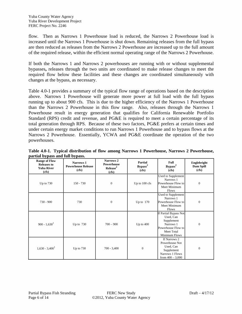
flow. Then as Narrows 1 Powerhouse load is reduced, the Narrows 2 Powerhouse load is increased until the Narrows 1 Powerhouse is shut down. Remaining releases from the full bypass are then reduced as releases from the Narrows 2 Powerhouse are increased up to the full amount of the required release, within the efficient normal operating range of the Narrows 2 Powerhouse. If both the Narrows 1 and Narrows 2 powerhouses are running with or without supplemental bypasses, releases through the two units are coordinated to make release changes to meet the required flow below these facilities and these changes are coordinated simultaneously with changes at the bypass, as necessary. Table 4.0-1 provides a summary of the typical flow range of operations based on the description above. Narrows 1 Powerhouse will generate more power at full load with the full bypass running up to about 900 cfs. This is due to the higher efficiency of the Narrows 1 Powerhouse than the Narrows 2 Powerhouse in this flow range. Also, releases through the Narrows 1 Powerhouse result in energy generation that qualifies for California Renewable Portfolio Standard (RPS) credit and revenue, and PG&E is required to meet a certain percentage of its total generation through RPS. Because of these two factors, PG&E prefers at certain times and under certain energy market conditions to run Narrows 1 Powerhouse and to bypass flows at the Narrows 2 Powerhouse. Essentially, YCWA and PG&E coordinate the operation of the two powerhouses. Table 4.0-1. Typical distribution of flow among Narrows 1 Powerhouse, Narrows 2 Powerhouse, partial bypass and full bypass.
Range of Flow Releases to Yuba River
(cfs)
Narrows 1 Powerhouse Release
(cfs)
Narrows 2 Powerhouse
Release2 (cfs)
Partial Bypass2
(cfs)
Full Bypass2
(cfs)
Englebright Dam Spill
(cfs)
Up to 730 150 - 730 0 Up to 100 cfs
Used to Supplement Narrows 1
Powerhouse Flow to Meet Minimum
Flows
0
730 - 900 730 0 Up to 170
Used to Supplement Narrows 1
Powerhouse Flow to Meet Minimum
Flows
0
900 - 1,6301 Up to 730 700 – 900 Up to 400
If Partial Bypass Not Used, Can
Supplement Narrows 1
Powerhouse Flow to Meet Total
Minimum Flows
0
1,630 - 3,4001 Up to 730 700 - 3,400 0
If Narrows 2 Powerhouse Not
Used, Can Supplement
Narrows 1 Flows from 400 – 3,000
0

Yuba County Water Agency Yuba River Development Project
FERC Project No. 2246
May 2013 FERC New Study Partial Bypass Fish Stranding ©2012, Yuba County Water Agency Page 7 of 14
Table 4.0-1. (continued) Range of Flow
Releases to Yuba River
(cfs)
Narrows 1 Powerhouse Release
(cfs)
Narrows 2 Powerhouse
Release2 (cfs)
Partial Bypass2
(cfs)
Full Bypass2
(cfs)
Englebright Dam Spill
(cfs)
3,400 - 4,130 Up to 730 2,670 – 3,400 0 0 0 > 4,130 Up to 730 3,400 0 0 All remaining flow
1 The use of the Narrows 1 Powerhouse in this range is dependent on a number of economic factors and can vary from no flow to the maximum Narrows 1 Powerhouse capacity. The table provides a typical operation when use of Narrows 1 Powerhouse is preferred.
2 The typical operating flow ranges of Narrows 2 facilities are limited by long-term reliability considerations, such as vibration and cavitation of runners; and are as follows: the Narrows 2 Powerhouse between 700 and 3,400 cfs; the partial bypass between 0 and 400 cfs; and the full bypass between 400 and 3,000 cfs.
5.0 Study Methods and Analysis 5.1 Study Area The study area is the right bank (oriented downstream) of the Yuba River channel from the Narrows 2 Powerhouse downstream to a distance of approximately 250 ft. Figure 5.0-1 presents an overview of the study area and surrounding facilities.
Figure 5.0-1. Aerial image of the Narrows 2 powerhouse. Englebright Dam is at the top of the picture, and the Narrows 2 Powerhouse is in the center of the picture. 5.2 Study Period Since the study focuses primarily on anadromous fishes, fieldwork will occur from June to December. This is the period when anadromous fishes are likely to be in the vicinity of the

Yuba County Water Agency Yuba River Development Project FERC Project No. 2246
Partial Bypass Fish Stranding FERC New Study May 2013 Page 8 of 14 ©2012, Yuba County Water Agency
Narrows 2 Powerhouse. See Section 7 for additional detail regarding the study schedule. 5.3 General Concepts and Procedures The following general concepts and practices apply to the study: Personal safety is the most important consideration of each fieldwork team.
YCWA’s field crews may make minor variances to the FERC-approved study in the field to accommodate actual field conditions and unforeseen problems. When minor variances are made, YCWA’s field crew will follow the protocols in the FERC-approved study.
When YCWA becomes aware of major variances to the FERC-approved study, YCWA will issue an e-mail to the Relicensing Contact List describing the variance and reason for the variance. YCWA will contact by phone the NMFS, USFWS, SWRCB and CDFW to provide an opportunity for input regarding how to address the variance. YCWA will issue an e-mail to the Relicensing Contact List advising them of the resolution of the variance. YCWA will summarize in the final study technical memorandum any variances and resolutions.
YCWA’s performance of the study does not presume that YCWA is responsible in whole or in part for measures that may arise from the study.
Global Positioning System (GPS) data will be collected using either a Map Grade Trimble GPS (sub-meter data collection accuracy under ideal conditions), a Recreation Grade Garmin GPS unit (3 meter data collection accuracy under ideal conditions), or similar units. GPS data will be post-processed and exported from the GPS unit into Geographic Information System (GIS) compatible file format in an appropriate coordinate system using desktop software. The resulting GIS file will then be reviewed by both field staff and Licensee’s relicensing GIS analyst. Metadata will be developed for deliverable GIS data sets. Upon request, GIS maps will be provided to agencies in a form, such as ESRI Shapefiles, GeoDatabases, or Coverage with appropriate metadata, that is useful for interactive data analysis and interpretation. Metadata will be Federal Geographic Data Committee (FGDC) compliant.
YCWA’s field crews will record incidental observations of aquatic and wildlife species observed during the performance of this study. All incidental observations will be reported in the appropriate YCWA technical memorandum. The purpose of this effort is not to conduct a focused study (i.e., no effort in addition to the specific field tasks identified for the particular study) or to make all field crews experts in identifying all species, but only to opportunistically gather data during the performance of the study.
Field crews will be trained on and provided with materials (e.g., Quat) for decontaminating their boots, waders, and other equipment between study sites. Major concerns are amphibian chytrid fungus, and invasive invertebrates (e.g., zebra mussel, Dreissena polymorpha). This is of primary importance when moving: 1) between tributaries and mainstem reaches; 2) moving between basins (e.g., Middle Yuba River, Yuba River, and North Yuba River); and 3) moving between isolated wetlands or ponds and river or stream environments.

Yuba County Water Agency Yuba River Development Project
FERC Project No. 2246
May 2013 FERC New Study Partial Bypass Fish Stranding ©2012, Yuba County Water Agency Page 9 of 14
5.4 Study Methods The study includes seven steps: 1) obtain necessary permits/approvals to perform the study; 2) perform fish stranding surveys; 3) perform visual observation of fish behavior from Narrows 2 Powerhouse deck; 4) describe operations during fish stranding monitoring; 5) summarize historical partial bypass operation since construction of the full bypass if the monitoring indicates operations of the partial bypass is resulting in fish stranding; 6) conduct data quality assurance/quality control; and 7) include study results in Study 7.11 Technical Memorandum. Each step is described below. 5.4.1 Step 1 – Obtain Necessary Permits If YCWA encounters stranded life Chinook salmon or steelhead, it can either leave the fish (i.e., do not handle them) or return them to the stream (i.e., handle them). If YCWA handles the fish, YCWA would first need necessary approvals or permits from NMFS since the fish species may be listed as threatened under the ESA. Therefore, YCWA will consult with NMFS regarding obtaining the appropriate permits and approvals after FERC approves the study. If YCWA’s fisheries biologists performing the study obtain the necessary permits or approvals, YCWA will handle stranded live fish. If the necessary permits or approvals are not obtained, YCWA will not handle the fish. 5.4.2 Step 2 – Perform Fish Stranding Surveys Immediately after operation of the partial bypass ceases5 (i.e., zero flow through the partial bypass), YCWA will conduct searches for stranded fish along the right bank (oriented downstream) of the Yuba River from the Narrows 2 Powerhouse downstream for approximately 250 ft, which is the extent of the spray from the bypass when operating at full capacity. The primary objective of this step will be to visually determine the presence or absence of stranded fish in edgewater, backwater, perched habitats, and on exposed bars in the study area. The survey method will be from both above and below the water (snorkeling). Only deeper (i.e., >1-2 feet) perched and backwater habitats will be snorkeled. Potential stranding areas less than 1 – 2 feet deep will be surveyed by wading facing or at an oblique angle to the sun to avoid shadows and observers will wear polarized sun glasses. Field crews will consist of two persons experienced in snorkeling and fish identification, and with the necessary permits/approvals to perform the surveys. Surveyors will begin on the bank adjacent to the partial bypass and continue slowly downstream searching edgewater, backwater, perched habitats, and exposed bars for stranded fish. Particular attention will be given to the area of the bank previously wetted by the partial bypass and in spaces between large boulders.
5 The study does not require YCWA operate the partial bypass for study purposes. The bypass will only be operated during the
study period under normal operations.

Yuba County Water Agency Yuba River Development Project FERC Project No. 2246
Partial Bypass Fish Stranding FERC New Study May 2013 Page 10 of 14 ©2012, Yuba County Water Agency
If stranded fish are found, the staff will record for each stranded fish species:
The number of fish (i.e., counted if possible, but if more than 15 fish, estimated abundance)
Size of fish (i.e., by measuring each individual fish or if more than 15 fish are found, estimating the number and size of fish in size bins of 0 to 50 millimeters (mm), 50 to 100 mm, 100 to 150 mm, 150 mm to 200 mm, and larger than 200 mm)
If the fish is dead, condition of the carcass (i.e., gravid, spent, signs of hemorrhaging, rigormortis, state of decomposition, and wounds likely inflicted by predators). Deceased fish will be marked (i.e., tail removed) and returned to the water to prevent them from being re-documented during future surveys
If the fish is alive and appropriate permits for handling are acquired, staff will return the fish to the water and note apparent condition (i.e., signs of stress), and a description of how and where the fish was returned to the flowing water in the main channel (i.e., preferred method will be to fill a bucket with water from the nearby main channel, use a hand net to capture the stranded fish and place it in the bucket, and place the bucket in the main channel so the fish can swim out of the bucket into the flowing water). Behavior of the fish (i.e., actively swims away, lethargic, etc.) as it leaves the bucket will be documented. If appropriate permits are not available, staff will not handle live fish.
Location of stranding, including GPS coordinate, distance from main channel and Narrows 2 Powerhouse, estimate of how far above the flowing water in the main channel standing occurred, depth of water at stranding location, and dominant/subdominant substrate at and nearby the stranding location
Temperature of the water if the stranded fish is found in water, and the temperature of the water in the main channel nearest to the stranded fish
Photographs of where standing occurs to document the dimensions, general habitat features, and degree of isolation from the main channel. The degree of isolation and ability of fish to return to the main river will be visually assessed based on fish size (i.e., body depth) and the depth, continuity, and direction of flow between the standing location and the main channel
In addition, staff will record for each standing survey:
Average combined flow being released through the Narrows 2 Powerhouse, full bypass, and partial bypass (and spill over Englebright Dam, if occurring) in the hour before the survey began (i.e., before the partial bypass cease operating)
The time the partial bypass ceased operating
The time the survey began and ended
Average combined flow being released through the Narrows 2 Powerhouse and full bypass (and spill over Englebright Dam, if occurring) during the fish stranding survey (i.e., partial bypass not operating)

Yuba County Water Agency Yuba River Development Project
FERC Project No. 2246
May 2013 FERC New Study Partial Bypass Fish Stranding ©2012, Yuba County Water Agency Page 11 of 14
Weather conditions during the survey 5.4.3 Step 3 – Visual Observations of Fish Behavior As requested by NMFS, prior to and after performing each fish stranding survey, the staff performing the survey will spend at least 20 minutes on the Narrows 2 Powerhouse deck observing the river near the powerhouse. If fish are observed, staff will record the estimated size of the fish, its location in relation to the powerhouse, and its behavior. If staff can identify the species of the fish with certainty, they will do so. 5.4.4 Step 4 – Operations during Surveys YCWA will provide in the final technical memorandum a list of each partial bypass shutdown during the study including for each shutdown 15-minute flow data combined for the Narrows 2 Powerhouse, partial bypass, and full bypass for the 4 hours prior to the shutdown and the first 4 hours after the partial bypass ceased operating. The data will be summarized in plots and provided in Microsoft™ Excel format. 5.4.5 Step 5 – Historical Operations of Partial Bypass In the event that results of the fish stranding surveys indicate that operation of the partial bypass may be contributing to salmonid stranding, YCWA will include a summary of the historical operation of the partial bypass since operation of the full bypass commenced.6 The historical operational data could be used to assess the frequency of the potential effect and the appropriateness of potential license conditions.
Specific information will include a summary of the historical operation of the partial-bypass, including frequency of use, seasonal use data, and typical duration of use. 5.4.6 Step 6 - Data QA/QC All collected and entered data will be reviewed for accuracy. Data sheets will be reviewed at the end of each field day by the lead field scientist to ensure all required data cells are populated appropriately. Finalized datasheets will be entered into Microsoft Excel or Access database and then reviewed for entry accuracy. Database quality assurance and quality control (QA/QC) will consist of a technician reading off the original datasheet information to a second technician affirming appropriate database entry. Only finalized data will be analyzed and presented within the Study technical memorandum. 5.4.7 Step 7 – Include Study Results in Study 7.11 Technical Memorandum Results of Study 7.13, Fish Stranding Surveys Near Narrows 2 Powerhouse Partial Bypass, will be included in Technical Memorandum 7-11 for Study 7.11, Fish Behavior and Hydraulics Near Narrows 2 Powerhouse.
6 A brief summary of the partial bypasses recent operations is provided in Section 4.
Yuba County Water Agency Yuba River Development Project FERC Project No. 2246
Partial Bypass Fish Stranding FERC New Study May 2013 Page 12 of 14 ©2012, Yuba County Water Agency
6.0 Study-Specific Consultation The study does not include any study-specific consultation, other than consulting with NMFS regarding permits and approvals.
7.0 Schedule The schedule below assumes no fish rescue or handling of live fish and/or YCWA’s fishery biologists obtain the necessary permits and approvals to handle ESA-listed fish species in a timely fashion. Obtain Written Authorization to Handle Fish or Exclude Fish Rescue (Step 1) .............. May 2013 Conduct Field Monitoring (Step 2) ............................................................... June – December 2013 Data QA/QC and Operations Analysis (Steps 3 – 5) ............................................... December 2013 Prepare Report (Step 6) .............................................................................. January - February 2014
8.0 Consistency of Methodology with Generally Accepted Scientific Practices
The methods presented in this study plan are consistent with other generally accepted scientific study methods concerning anadromous salmonid population assessments, including those conducted by the resource agencies in California. The study also integrated prior-approved field methods detailed in YCWA’s relicensing Study 3.12, New Colgate Powerhouse Ramping.
9.0 Level of Effort and Cost YCWA estimates the cost to complete this study in 2013 dollars is between $5,000 and $50,000, depending on how often the partial bypass sis operated during the study period.
10.0 Attachments This study plan includes one attachment:
Attachment 7-12A Documentation of Transmittal of Draft Study Plan to NMFS,
USFWS and CDFW for 21-Day Review and Comment YCWA did not receive any written comments on YCWA’s draft study plan from NMFS, USFWS or CDFW.

Yuba County Water Agency Yuba River Development Project
FERC Project No. 2246
May 2013 FERC New Study Partial Bypass Fish Stranding ©2012, Yuba County Water Agency Page 13 of 14
10.0 References Cited Yuba County Water Agency (YCWA). 2010. Yuba River Development Project relicensing Pre-
Application Document. Yuba County Water Agency, Marysville, CA. http://www.ycwa-relicensing.com.

Yuba County Water Agency Yuba River Development Project FERC Project No. 2246
Partial Bypass Fish Stranding FERC New Study May 2013 Page 14 of 14 ©2012, Yuba County Water Agency
Page Left Blank

1
Pitts, Sheila
From: Lynch, JimSent: Tuesday, May 14, 2013 2:47 PMTo: Pitts, SheilaSubject: FW: Yuba Relicensing: Draft Study 7.13, Fish Stranding Associated with Shutdown of
the Narrows 2 Powerhouse Partial Bypass, for Your Review (Comments due by COB 5/7)
Attachments: Study 7-13 - Fish Stranding Associated with Narrows Partial Bypass - Draft - 041713.doc
JAMES LYNCH HDR Engineering, Inc. Senior Vice President, Hydropower Services
2379 Gateway Oaks, Suite 200 | Sacramento, CA 95833 916.679.8700 | d: 916.679.8740 |c: 916.802.6247 [email protected] | hdrinc.com
NOTICE: This message is intended only for the use of the individual or entity to which it is addressed, and may contain confidential and/or privileged information. If you are not the intended recipient, please notify the sender and destroy this e‐mail. In addition, any unauthorized copying, disclosure or distribution of this e‐mail, any attachment, or any material contained therein is strictly prohibited.
From: Lynch, Jim Sent: Wednesday, April 17, 2013 11:52 AM To: [email protected]; [email protected]; [email protected]; Ramon Martin; 'Soule, Laurie@Wildlife' ([email protected]); Lynch, MaryLisa@Wildlife ([email protected]) ([email protected]) Cc: Curt Aikens ([email protected]); Geoff Rabone; Kopp, Gabriel Subject: Yuba Relicensing: Draft Study 7.13, Fish Stranding Associated with Shutdown of the Narrows 2 Powerhouse Partial Bypass, for Your Review (Comments due by COB 5/7) Rick, John, Alison, Ramon, MaryLisa and Laurie ‐ In its March 29, Determination on Requests for Modifications to the Yuba River Hydroelectric Project Study Plan, the Federal Energy Regulatory Commission (FERC or Commission) stated in part: “YCWA should develop and implement a stranding survey study. YCWA should conduct this study immediately after operations of the partial‐bypass cease. To ensure the stranding survey is consistent with generally accepted practices in the scientific community (study criterion 6), YCWA should develop a protocol after consultation with the NMFS, FWS, and California Fish and Wildlife, and include provisions for documenting location of stranded fish, condition of carcass (e.g., gravid, spent, signs of hemorrhage, rigor‐mortis, decomposition, or wounds likely inflicted by predators), and include methods for documenting and handling any live fish that may be discovered. The standing survey study and associated survey protocols should be filed with the Commission for approval by May 15, 2013.” At an April 3, 2013 meeting, USFWS and CDFW agreed YCWA would develop a draft study plan and by April 17, 2013 provide it to the agencies via e‐mail for a 20‐day review period. Red lines of the draft study plan would be returned to YCWA by close of business on May 7, 2013. YCWA would address comments in its final study plan and file the final, with agencies’ written comments, with FERC by May 15, 2013. Attached is a Microsoft™ Word version of the draft Study 7.13, Fish Stranding Associated with Shutdown of the Narrows 2 Powerhouse Partial Bypass, for you review.
2
If you have any questions regarding this draft study plan, please contact Jim Lynch. Curt Aikens General Manager Yuba County Water Agency 530‐741‐6278 x 115 This e‐mail sent NMFS, USFWS and CDFW on behalf of the above party by:
JAMES LYNCH HDR Engineering, Inc. Senior Vice President, Hydropower Services
2379 Gateway Oaks, Suite 200 | Sacramento, CA 95833 916.679.8700 | d: 916.679.8740 |c: 916.802.6247 [email protected] | hdrinc.com
NOTICE: This message is intended only for the use of the individual or entity to which it is addressed, and may contain confidential and/or privileged information. If you are not the intended recipient, please notify the sender and destroy this e‐mail. In addition, any unauthorized copying, disclosure or distribution of this e‐mail, any attachment, or any material contained therein is strictly prohibited.

Yuba County Water Agency Yuba River Development Project
FERC Project No. 2246
Draft – 4/17/12 FERC New Study Partial Bypass Fish Stranding ©2012, Yuba County Water Agency Page 1 of 14
DRAFT Study 7.13
FISH STRANDING ASSOCIATED WITH SHUTDOWN OF
NARROWS 2 POWERHOUSE PARTIAL BYPASS April 2013
1.0 Project Nexus Yuba County Water Agency’s (Licensee or YCWA) continued operation and maintenance (O&M) of the Yuba River Development Project (Project) has the potential to affect resident and anadromous salmonid fish species in the Yuba River near the Project’s Narrows 2 Powerhouse by stranding fish. The powerhouse is located approximately 400 feet (ft) downstream of the United States Army Corps of Engineers’ (USACE) Englebright Dam.1 While this study examines stranding of all fish species, it focuses on Central Valley spring-run Chinook salmon (Oncorhynchus tshawytscha), Central Valley steelhead (O. mykiss), and Central Valley fall-run Chinook salmon (O. tshawytscha). Spring-run Chinook salmon and steelhead are listed as threatened under the federal Endangered Species Act (ESA). Fall-run Chinook salmon is listed as a federal species of concern by the United States Department of Commerce, National Oceanic and Atmospheric Administration, National Marine Fisheries Service (NMFS).
2.0 Resource Management Goals of Agencies with Jurisdiction Over the Resource to be Studied
YCWA believes that four agencies have jurisdiction over fish that could be potentially affected in the geographic area included in this study proposal: 1) United States Department of Interior, Fish and Wildlife Service (USFWS); 2) NMFS; 3) California Department of Fish and Wildlife (CDFW);2 and 4) State Water Resources Control Board, Division of Water Rights (SWRCB). Each of these agencies and their jurisdiction and management direction, as understood by YCWA at this time, is discussed below.
1 Englebright Dam was constructed by the California Debris Commission in 1941; is owned, operated and maintained by the
USACE; and is not included as a Project facility in FERC licenses for the Yuba River Development Project. Englebright Reservoir is formed by Englebright Dam. The dam is about 260 feet high; was constructed by the California Debris Commission in 1941; is owned by the United States; and the dam, reservoir and associated recreation facilities are not included as Project facilities in FERC’s license for the Yuba River Development Project. When the California Debris Commission was decommissioned in 1986, administration of Englebright Dam and Reservoir passed to the USACE. The primary purpose of the dam is to trap and contain sediment derived from extensive historic hydraulic mining operations in the Yuba River watershed. Englebright Reservoir is about 9 miles long with a surface area of 815 acres. When the dam was first constructed in 1941, it had a gross storage capacity of 70,000 ac-ft; however, due to sediment capture, the gross storage capacity today is approximately 50,000 ac-ft (USGS 2003).
2 CDFW was previously known as the California Department of Fish and Game, of CDFG.

Yuba County Water Agency Yuba River Development Project FERC Project No. 2246
Partial Bypass Fish Stranding FERC New Study Draft – 4/17/12 Page 2 of 14 ©2012, Yuba County Water Agency
USFWS USFWS’s jurisdiction and goals and objectives are described by USFWS on pages 1 through 3 of USFWS’s March 7, 2011 letter to FERC that provided USFWS’s comments on YCWA’s Pre-Application Document, or PAD (YCWA 2010). USFWS’s jurisdiction, goals and objectives are not repeated here. NMFS NMFS’s statutory authorities and responsibilities are described by NMFS in Section 2.0 of Enclosure A in NMFS’s March 7, 2011 letter to FERC providing NMFS’s comments on YCWA’s PAD. NMFS’s jurisdiction and responsibilities are not repeated here. CDFW CDFW’s jurisdiction is described by CDFW on page 1 of CDFW’s March 2, 2011 letter to FERC providing CDFW’s comments on YCWA’s PAD. CDFW’s goal, as described on page 2 of CDFW’s letter is to preserve, protect, and as needed, to restore habitat necessary to support native fish, wildlife and plant species within the FERC boundaries and downstream of the Project as resources are affected by ongoing facility operations. SWRCB SWRCB has authority under the federal Clean Water Act (33 U.S.C. §11251-1357) to restore and maintain the chemical, physical and biological integrity of the Nation’s waters. Throughout the relicensing process the SWRCB maintains independent regulatory authority to condition the operation of the Project to protect water quality and the beneficial uses of stream reaches consistent with Section 401 of the federal Clean Water Act, the Regional Water Quality Control Board Basin Plans, State Water Board regulations, California Environmental Quality Act (CEQA), and any other applicable state law.
3.0 Study Goals and Objectives In its March 29, Determination on Requests for Modifications to the Yuba River Hydroelectric Project Study Plan, the Federal Energy Regulatory Commission (FERC or Commission) stated:
YCWA should develop and implement a stranding survey study. YCWA should conduct this study immediately after operations of the partial-bypass cease. To ensure the stranding survey is consistent with generally accepted practices in the scientific community (study criterion 6), YCWA should develop a protocol after consultation with the NMFS, FWS, and California Fish and Wildlife, and include provisions for documenting location of stranded fish, condition of carcass (e.g., gravid, spent, signs of hemorrhage, rigor-mortis, decomposition, or wounds likely inflicted by predators), and include methods for documenting and handling any live fish that may be discovered. The standing survey study and associated survey protocols should be filed with the Commission for approval by May 15, 2013.

Yuba County Water Agency Yuba River Development Project
FERC Project No. 2246
Draft – 4/17/12 FERC New Study Partial Bypass Fish Stranding ©2012, Yuba County Water Agency Page 3 of 14
Results of the stranding surveys should be included in study report for Study 7.11. Additionally, if results of the stranding survey indicated that operation of the partial bypass may be affecting salmonids, YCWA should include a summary of the historical operation of the partial-bypass, including frequency of use, seasonal use data, and typical duration of use. Costs associated with the implementation of stranding surveys following the operation of the partial-bypass would be marginal and essentially associated with report preparation because a person who could conduct the stranding surveys would already be on-site during operational changes (study criterion 7).
Therefore, the goal of the study is to gain a better understanding of the relationship between shutdown of the Narrows 2 Powerhouse partial bypass and fish stranding. The objective is to document the occurrence and condition of any fish apparently stranded after shut down of the bypass.
4.0 Existing Information and Need for Additional Information3
This discussion pertains to the coordinated operations of YCWA’s Narrows 2 Powerhouse and the PG&E’s Narrows 1 Powerhouse for releases to the Yuba River. The combined release capacity of the two powerhouses and associated bypass facilities is 4,130 cubic feet per second (cfs), comprised of the maximum release of the Narrows 2 Powerhouse (3,400 cfs) and the Narrows 1 Powerhouse (730 cfs). Neither of these two powerhouses operates their respective bypass facilities when the powerhouse turbines are in normal operation. YCWA can release water into the Yuba River past the Narrows 2 Powerhouse using one of two bypasses. The first is called the Narrows 2 Full Flow Bypass (i.e., full bypass). The full bypass is a valve and penstock branch off the Narrows 2 Penstock, which can discharge up to 3,000 cfs of water at full head into the Yuba River immediately upstream of the Narrows 2 Powerhouse through a 72-inch diameter fixed-cone valve. The full bypass was installed in 2008 to maintain higher minimum flows during times of full shutdown of the Narrows 2 Powerhouse. The second facility for releasing water past the Narrows 2 Powerhouse is called the Narrows 2 Partial Flow Bypass (i.e., partial bypass). This is a pipe off the Narrows 2 Powerhouse turbine scroll case, which can discharge up to 650 cfs of water at full head into the Yuba River through a 36-inch valve located on the downstream face of the powerhouse above the draft tube outlet. The partial bypass was built as part of the original design when the Narrows 2 Powerhouse was constructed. YCWA normally uses the partial bypass to release no more than about 300 cfs (i.e., the full bypass is used for higher flow releases). Figure 4.0-1 shows the partial bypass in operation.
3 Much of the information presented in Section 4.0 is described in Technical Memorandum 7-11, Fish Behavior and Hydraulics
Near the Narrows 2 Powerhouse.

Yuba County Water Agency Yuba River Development Project FERC Project No. 2246
Partial Bypass Fish Stranding FERC New Study Draft – 4/17/12 Page 4 of 14 ©2012, Yuba County Water Agency
Figure 4.0-1. Operation of the partial bypass at Narrows 2 Powerhouse. Use of the partial bypass is infrequent. From December 22, 2009 through April 10, 2012, YCWA operated the partial bypass during five events: twice in 2010 and twice in 2012. The partial bypass was not used in 2011. These five events4 were:
September 1, 2010 – Partial bypass opened from 7:29 AM to 11:50 AM. Maximum flow through the valve was 428 cfs.
September 30, 2010 – Partial bypass opened from 11:39 AM to 2:45 PM. Maximum flow through valve was 300 cfs.
January 19 though 21, 2012 – Partial bypass opened for most of the 3 days. Maximum flow though the valve was 76 cfs.
January 30 to March 14, 2012 - Partial bypass opened for most of the 45 days. Maximum flow though the valve was 68 cfs.
September 21, 2012 – Partial bypass open from 9:59 AM to 12:59 PM. Maximum flow through the valve was 380 cfs.
4 In addition, the partial bypass was opened on October 25, 2012 from 7:22 AM through 11:45 AM to accommodate a
relicensing study. This is not listed as one of the events because it was related to relicensing, not normal Project operations.

Yuba County Water Agency Yuba River Development Project
FERC Project No. 2246
Draft – 4/17/12 FERC New Study Partial Bypass Fish Stranding ©2012, Yuba County Water Agency Page 5 of 14
Since installation of the full bypass, the partial bypass is typically only used for a few specific reasons, which include: 1) maintenance on the full bypass when generation is not possible; 2) obtaining foot access above the full bypass when generation is not possible; and 3) supplemental flow releases generally less than 100 cfs. Low-flow release below 100 cfs is not a hard rule, but the full bypass is switched over to the partial bypass if vibrational noise begins to occur at lower flows through the full bypass, which generally occur when less than 100 cfs is released. Except for transitional periods as described below, YCWA does not operate either the full or partial bypasses when Narrows 2 Powerhouse is operating (i.e., water is passing through the turbine and generating electricity), and does not operate both bypasses at the same time. Emergency conditions or release changes from either of the powerhouses is coordinated between the turbine flows and bypass flows of the two facilities. Many operational scenarios are possible. The following is a description of standard operational practice for emergency conditions and changeovers from one powerhouse to the other. Deviations form these practices can occur. If during normal operation of the Narrows 2 Powerhouse a shutdown of the unit occurs because of a forced outage, which could include a transmission outage, the turbine shutoff value (TSV) is closed automatically and there is an automatic opening of the full bypass valve. The opening of the full bypass valve is started after a 3 minute safety delay during which time a horn is sounded at the exterior of the bypass to warn persons in the area of an imminent release through the full bypass. This operation is automatic and does not require any manual actions. Once the outage has been cleared, the TSV is opened by an operator, the Narrows 2 Powerhouse unit is synchronized to the electrical grid, and then the bypass valve is manually closed in increments synchronized with increased load and resulting releases through the powerhouse. This can be done by an operator located at the plant or at a remote location. If the Narrows 2 Powerhouse is operating, but the Narrows 1 Powerhouse is not operating, and releases below the dam are to be reduced into a less efficient range for the Narrows 2 Powerhouse, PG&E may decide to generate electricity at the Narrows 1 Powerhouse, which is more efficient than the Narrows 2 Powerhouse at lower flows. In this case, a changeover operation occurs to reduce releases from the Narrows 2 Powerhouse and increase releases from the Narrows 1 Powerhouse. For this operation, the first step is for PG&E to synchronize the Narrows 1 Powerhouse unit to the electric grid with small releases and operate at low load in parallel with the Narrows 2 Powerhouse. As the Narrows 1 Powerhouse load and releases are increased, releases from the Narrows 2 Powerhouse are decreased and the full bypass is opened to the desired flow rate needed to supplement the Narrows 1 Powerhouse release, if any. If the required bypass amount is less than approximately 300 cfs, the partial bypass is used instead of the full bypass. The transition of releases from the Narrows 1 Powerhouse to the Narrows 2 Powerhouse occurs in reverse of the process described above. If flows into the Yuba River below Englebright Dam need to be increased while the Narrows 1 Powerhouse is operating, but the Narrows 2 Powerhouse is not operating, and the full bypass is being used to release a supplemental amount of flow, the first step is for the Narrows 2 unit to be synchronized to the electric grid with a small
Yuba County Water Agency Yuba River Development Project FERC Project No. 2246
Partial Bypass Fish Stranding FERC New Study Draft – 4/17/12 Page 6 of 14 ©2012, Yuba County Water Agency
flow. Then as Narrows 1 Powerhouse load is reduced, the Narrows 2 Powerhouse load is increased until the Narrows 1 Powerhouse is shut down. Remaining releases from the full bypass are then reduced as releases from the Narrows 2 Powerhouse are increased up to the full amount of the required release, within the efficient normal operating range of the Narrows 2 Powerhouse. If both the Narrows 1 and Narrows 2 powerhouses are running with or without supplemental bypasses, releases through the two units are coordinated to make release changes to meet the required flow below these facilities and these changes are coordinated simultaneously with changes at the bypass, as necessary. Table 4.0-1 provides a summary of the typical flow range of operations based on the description above. Narrows 1 Powerhouse will generate more power at full load with the full bypass running up to about 900 cfs. This is due to the higher efficiency of the Narrows 1 Powerhouse than the Narrows 2 Powerhouse in this flow range. Also, releases through the Narrows 1 Powerhouse result in energy generation that qualifies for California Renewable Portfolio Standard (RPS) credit and revenue, and PG&E is required to meet a certain percentage of its total generation through RPS. Because of these two factors, PG&E prefers at certain times and under certain energy market conditions to run Narrows 1 Powerhouse and to bypass flows at the Narrows 2 Powerhouse. Essentially, YCWA and PG&E coordinate the operation of the two powerhouses. Table 4.0-1. Typical distribution of flow among Narrows 1 Powerhouse, Narrows 2 Powerhouse, partial bypass and full bypass.
Range of Flow Releases to Yuba River
(cfs)
Narrows 1 Powerhouse Release
(cfs)
Narrows 2 Powerhouse
Release2 (cfs)
Partial Bypass2
(cfs)
Full Bypass2
(cfs)
Englebright Dam Spill
(cfs)
Up to 730 150 - 730 0 Up to 100 cfs
Used to Supplement Narrows 1
Powerhouse Flow to Meet Minimum
Flows
0
730 - 900 730 0 Up to 170
Used to Supplement Narrows 1
Powerhouse Flow to Meet Minimum
Flows
0
900 - 1,6301 Up to 730 700 – 900 Up to 400
If Partial Bypass Not Used, Can
Supplement Narrows 1
Powerhouse Flow to Meet Total
Minimum Flows
0
1,630 - 3,4001 Up to 730 700 - 3,400 0
If Narrows 2 Powerhouse Not
Used, Can Supplement
Narrows 1 Flows from 400 – 3,000
0

Yuba County Water Agency Yuba River Development Project
FERC Project No. 2246
Draft – 4/17/12 FERC New Study Partial Bypass Fish Stranding ©2012, Yuba County Water Agency Page 7 of 14
Table 4.0-1. (continued) Range of Flow
Releases to Yuba River
(cfs)
Narrows 1 Powerhouse Release
(cfs)
Narrows 2 Powerhouse
Release2 (cfs)
Partial Bypass2
(cfs)
Full Bypass2
(cfs)
Englebright Dam Spill
(cfs)
3,400 - 4,130 Up to 730 2,670 – 3,400 0 0 0 > 4,130 Up to 730 3,400 0 0 All remaining flow
1 The use of the Narrows 1 Powerhouse in this range is dependent on a number of economic factors and can vary from no flow to the maximum Narrows 1 Powerhouse capacity. The table provides a typical operation when use of Narrows 1 Powerhouse is preferred.
2 The typical operating flow ranges of Narrows 2 facilities are limited by long-term reliability considerations, such as vibration and cavitation of runners; and are as follows: the Narrows 2 Powerhouse between 700 and 3,400 cfs; the partial bypass between 0 and 400 cfs; and the full bypass between 400 and 3,000 cfs.
5.0 Study Methods and Analysis 5.1 Study Area The study area is the right bank (oriented downstream) of the Yuba River channel from the Narrows 2 Powerhouse downstream to a distance of approximately 250 ft. Figure 5.0-1 presents an overview of the study area and surrounding facilities.
Figure 5.0-1. Aerial image of the Narrows 2 powerhouse. Englebright Dam is at the top of the picture, and the Narrows 2 Powerhouse is in the center of the picture. 5.2 Study Period Since the study focuses primarily on anadromous fishes, fieldwork will occur from June to December. This is the period when anadromous fishes are likely to be in the vicinity of the Narrows 2 Powerhouse. See Section 7 for additional detail regarding the study schedule.
Yuba County Water Agency Yuba River Development Project FERC Project No. 2246
Partial Bypass Fish Stranding FERC New Study Draft – 4/17/12 Page 8 of 14 ©2012, Yuba County Water Agency
5.3 General Concepts and Procedures The following general concepts and practices apply to the study: Personal safety is the most important consideration of each fieldwork team.
YCWA’s field crews may make minor variances to the FERC-approved study in the field to accommodate actual field conditions and unforeseen problems. When minor variances are made, YCWA’s field crew will follow the protocols in the FERC-approved study.
When YCWA becomes aware of major variances to the FERC-approved study, YCWA will issue an e-mail to the Relicensing Contact List describing the variance and reason for the variance. YCWA will contact by phone the NMFS, USFWS, SWRCB and CDFW to provide an opportunity for input regarding how to address the variance. YCWA will issue an e-mail to the Relicensing Contact List advising them of the resolution of the variance. YCWA will summarize in the final study technical memorandum any variances and resolutions.
YCWA’s performance of the study does not presume that YCWA is responsible in whole or in part for measures that may arise from the study.
Global Positioning System (GPS) data will be collected using either a Map Grade Trimble GPS (sub-meter data collection accuracy under ideal conditions), a Recreation Grade Garmin GPS unit (3 meter data collection accuracy under ideal conditions), or similar units. GPS data will be post-processed and exported from the GPS unit into Geographic Information System (GIS) compatible file format in an appropriate coordinate system using desktop software. The resulting GIS file will then be reviewed by both field staff and Licensee’s relicensing GIS analyst. Metadata will be developed for deliverable GIS data sets. Upon request, GIS maps will be provided to agencies in a form, such as ESRI Shapefiles, GeoDatabases, or Coverage with appropriate metadata, that is useful for interactive data analysis and interpretation. Metadata will be Federal Geographic Data Committee (FGDC) compliant.
YCWA’s field crews will record incidental observations of aquatic and wildlife species observed during the performance of this study. All incidental observations will be reported in the appropriate YCWA technical memorandum. The purpose of this effort is not to conduct a focused study (i.e., no effort in addition to the specific field tasks identified for the particular study) or to make all field crews experts in identifying all species, but only to opportunistically gather data during the performance of the study.
Field crews will be trained on and provided with materials (e.g., Quat) for decontaminating their boots, waders, and other equipment between study sites. Major concerns are amphibian chytrid fungus, and invasive invertebrates (e.g., zebra mussel, Dreissena polymorpha). This is of primary importance when moving: 1) between tributaries and mainstem reaches; 2) moving between basins (e.g., Middle Yuba River, Yuba River, and North Yuba River); and 3) moving between isolated wetlands or ponds and river or stream environments.

Yuba County Water Agency Yuba River Development Project
FERC Project No. 2246
Draft – 4/17/12 FERC New Study Partial Bypass Fish Stranding ©2012, Yuba County Water Agency Page 9 of 14
5.4 Study Methods The study includes seven steps: 1) obtain necessary permits/approvals to perform the study; 2) perform fish stranding surveys; 3) perform visual observation of fish behavior from Narrows 2 Powerhouse deck; 4) describe operations during fish stranding monitoring; 5) summarize historical partial bypass operation since construction of the full bypass if the monitoring indicates operations of the partial bypass is resulting in fish stranding; 6) conduct data quality assurance/quality control; and 7) include study results in Study 7.11 Technical Memorandum. Each step is described below. 5.4.1 Step 1 – Obtain Necessary Permits Since the study includes the potential for handling live fish, some of which may be indistinguishable from those listed as threatened under the ESA, the YCWA study team will need to obtain the permits/approvals listed below prior to performing the study. YCWA considered the need of a Section 10 permit or a 4d Rule Research Authorization. Both permits provide coverage for handling ESA protected species. YCWA concluded the most expeditious pathway was the 4d Rule Research Authorization and presents the process below. 4d Rule Research Authorization Certain activities, including research and enhancement, that may result in the take of certain threatened species may be approved under ESA § 4(d). The permit is issued by NMFS and has a fixed window for application that is in the fall of each year and an authorization good for only 1 year, with option of renewal. The permitting application period is between mid-September through mid-October. The major steps in this process are: 1) CDFW must provide for NMFS’ review and approve a list of scientific research activities planned for the coming year. CDFW screens research applications and then works with NMFS to ensure authorized research does not over utilize the resource; 2) NMFS conducts an ESA § 7 and Magnuson-Stevens Fishery Conservation and Management Act consultation on the proposed issuance of the approval of the research program, resulting in a biological opinion. NMFS advises CDFW whether the submittal has been approved or rejected within 6 weeks of the date a complete submittal is received; and 3) researchers are covered under the research limit as soon as CDFW receives a letter from NMFS’ Northwest Regional Administrator that their submittal has been approved. Based on previous experience, the permit is likely to be issued no earlier than March 2014. The permit would require specific identified experienced biologists to conduct the work. [NMFS – If NMFS approves YCWA not handling live fish (if we see a stranded live fish, we leave it), we could delete this section from the study plan and simply say we would not handle fish. That would allow the study to proceed in 2013. Please advise. YCWA 4/17] Scientific Collection Permit This permit is issued by the CDFW under Fish and Game Code Section 1002 and Title 14 Sections 650 and 670.7. The permit allows for take, collection, capture, mark, or salvage of fish
Yuba County Water Agency Yuba River Development Project FERC Project No. 2246
Partial Bypass Fish Stranding FERC New Study Draft – 4/17/12 Page 10 of 14 ©2012, Yuba County Water Agency
for scientific purposes. The permit can be applied for at any time and takes a minimum of 26 weeks to process. In addition, a Memorandum of Understanding is required when handling state listed species. This permit would be required in addition to protections afforded by the 4d Rule Research Authorization. Processing time for a Collection Permit would likely result in the permit being granted by November 2013. A Memorandum of Understanding could be developed within the month of issuance depending on the availability of the regional biologist to issue it. In limited instances, written authorization can be given within a one-month period based on the approval of a regional biologist. These special case written authorizations are at the discretion of the regional biologist and require that the field technicians have an existing collection permit for other activities that would not include the current action. 5.5.1 Step 2 – Perform Fish Stranding Surveys Immediately after operation of the partial bypass ceases5 (i.e., zero flow through the partial bypass), YCWA will conduct searches for stranded fish along the right bank (oriented downstream) of the Yuba River from the Narrows 2 Powerhouse downstream for approximately 250 ft, which is the extent of the spray from the bypass when operating at full capacity. The primary objective of this step will be to visually determine the presence or absence of stranded fish in edgewater, backwater, perched habitats, and on exposed bars in the study area. The survey method will be from both above and below the water (snorkeling). Only deeper (i.e., >1-2 feet) perched and backwater habitats will be snorkeled. Potential stranding areas less than 1 – 2 feet deep will be surveyed by wading facing or at an oblique angle to the sun to avoid shadows and observers will wear polarized sun glasses. Field crews will consist of two persons experienced in snorkeling and fish identification, and with the necessary permits/approvals to perform the surveys. Surveyors will begin on the bank adjacent to the partial bypass and continue slowly downstream searching edgewater, backwater, perched habitats, and exposed bars for stranded fish. Particular attention will be given to the area of the bank previously wetted by the partial bypass and in spaces between large boulders. If stranded fish are found, the staff will record for each stranded fish species:
The number of fish (i.e., counted if possible, but if more than 15 fish, estimated abundance)
Size of fish (i.e., by measuring each individual fish or if more than 15 fish are found, estimating the number and size of fish in size bins of 0 to 50 millimeters (mm), 50 to 100 mm, 100 to 150 mm, 150 mm to 200 mm, and larger than 200 mm)
5 The study does not require YCWA operate the partial bypass for study purposes. The bypass will only be operated during the
study period under normal operations.

Yuba County Water Agency Yuba River Development Project
FERC Project No. 2246
Draft – 4/17/12 FERC New Study Partial Bypass Fish Stranding ©2012, Yuba County Water Agency Page 11 of 14
If the fish is dead, condition of the carcass (i.e., gravid, spent, signs of hemorrhaging, rigormortis, state of decomposition, and wounds likely inflicted by predators). Deceased fish will be marked (i.e., tail removed) and returned to the water to prevent them from being re-documented during future surveys
If the fish is alive and appropriate permits for handling are acquired, staff will return the fish to the water and note apparent condition (i.e., signs of stress), and a description of how and where the fish was returned to the flowing water in the main channel (i.e., preferred method will be to fill a bucket with water from the nearby main channel, use a hand net to capture the stranded fish and place it in the bucket, and place the bucket in the main channel so the fish can swim out of the bucket into the flowing water). Behavior of the fish (i.e., actively swims away, lethargic, etc.) as it leaves the bucket will be documented. If appropriate permits are not available, staff will not handle live fish.
Location of stranding, including GPS coordinate, distance from main channel and Narrows 2 Powerhouse, estimate of how far above the flowing water in the main channel standing occurred, depth of water at stranding location, and dominant/subdominant substrate at and nearby the stranding location
Temperature of the water if the stranded fish is found in water, and the temperature of the water in the main channel nearest to the stranded fish
Photographs of where standing occurs to document the dimensions, general habitat features, and degree of isolation from the main channel. The degree of isolation and ability of fish to return to the main river will be visually assessed based on fish size (i.e., body depth) and the depth, continuity, and direction of flow between the standing location and the main channel
In addition, staff will record for each standing survey:
Average combined flow being released through the Narrows 2 Powerhouse, full bypass, and partial bypass (and spill over Englebright Dam, if occurring) in the hour before the survey began (i.e., before the partial bypass cease operating)
The time the partial bypass ceased operating
The time the survey began and ended
Average combined flow being released through the Narrows 2 Powerhouse and full bypass (and spill over Englebright Dam, if occurring) during the fish stranding survey (i.e., partial bypass not operating)
Weather conditions during the survey 5.4.3 Step 3 – Visual Observations of Fish Behavior As requested by NMFS, prior to and after performing each fish stranding survey, the staff performing the survey will spend at least 20 minutes on the Narrows 2 Powerhouse deck observing the river near the powerhouse. If fish are observed, staff will record the estimated size

Yuba County Water Agency Yuba River Development Project FERC Project No. 2246
Partial Bypass Fish Stranding FERC New Study Draft – 4/17/12 Page 12 of 14 ©2012, Yuba County Water Agency
of the fish, its location in relation to the powerhouse, and its behavior. If staff can identify the species of the fish with certainty, they will do so. 5.4.4 Step 4 – Operations during Surveys YCWA will provide in the final technical memorandum a list of each partial bypass shutdown during the study including for each shutdown 15-minute flow data combined for the Narrows 2 Powerhouse, partial bypass, and full bypass for the 4 hours prior to the shutdown and the first 4 hours after the partial bypass ceased operating. The data will be summarized in plots and provided in Microsoft™ Excel format. 5.4.5 Step 5 – Historical Operations of Partial Bypass In the event that results of the fish stranding surveys indicate that operation of the partial bypass may be contributing to salmonid stranding, YCWA will include a summary of the historical operation of the partial bypass since operation of the full bypass commenced.6 The historical operational data could be used to assess the frequency of the potential effect and the appropriateness of potential license conditions.
Specific information will include a summary of the historical operation of the partial-bypass, including frequency of use, seasonal use data, and typical duration of use. 5.4.6 Step 6 - Data QA/QC All collected and entered data will be reviewed for accuracy. Data sheets will be reviewed at the end of each field day by the lead field scientist to ensure all required data cells are populated appropriately. Finalized datasheets will be entered into Microsoft Excel or Access database and then reviewed for entry accuracy. Database quality assurance and quality control (QA/QC) will consist of a technician reading off the original datasheet information to a second technician affirming appropriate database entry. Only finalized data will be analyzed and presented within the Study technical memorandum. 5.4.7 Step 7 – Include Study Results in Study 7.11 Technical Memorandum Results of Study 7.13, Fish Stranding Surveys Near Narrows 2 Powerhouse Partial Bypass, will be included in Technical Memorandum 7-11 for Study 7.11, Fish Behavior and Hydraulics Near Narrows 2 Powerhouse.
6.0 Study-Specific Consultation The study does not include any study-specific consultation.
6 A brief summary of the partial bypasses recent operations is provided in Section 4.
Yuba County Water Agency Yuba River Development Project
FERC Project No. 2246
Draft – 4/17/12 FERC New Study Partial Bypass Fish Stranding ©2012, Yuba County Water Agency Page 13 of 14
7.0 Schedule YCWA acknowledges that study can progress in two potential pathways. The first pathway (Scenario 1) would assume no fish rescue or handling of live fish or would assume NMFS and CDFW would provide written authorization to handle fish in a month following study plan approval. The second schedule (Scenario 2) anticipates a full permitting period to provide coverage to perform fisheries rescues and surveys. Scenario 17 Obtain Written Authorization to Handle Fish or Exclude Fish Rescue (Step 1) .............. May 2013 Conduct Field Monitoring (Step 2) ............................................................... June – December 2013 Data QA/QC and Operations Analysis (Steps 3 – 5) ............................................... December 2013 Prepare Report (Step 6) .............................................................................. January - February 2014 Scenario 28 Apply for Necessary Permits (Step 1) ............................................................. May – October 2013 Conduct Field Monitoring (Step 2) ............................................................... June – December 2014 Data QA/QC and Operations Analysis (Steps 3 – 5) ............................................... December 2014 Prepare Report (Step 6) .............................................................................. January - February 2015
8.0 Consistency of Methodology with Generally Accepted Scientific Practices
The methods presented in this study plan are consistent with other generally accepted scientific study methods concerning anadromous salmonid population assessments, including those conducted by the resource agencies in California. The study also integrated prior-approved field methods detailed in YCWA’s relicensing Study 3.12, New Colgate Powerhouse Ramping.
9.0 Level of Effort and Cost YCWA estimates the cost to complete this study in 2013 dollars is between $5,000 and $50,000, depending on how often the partial bypass sis operated during the study period.
10.0 Attachments This study plan includes one attachment:
Attachment 7-12A Documentation of Transmittal of Draft Study Plan to NMFS,
USFWS and CDFW for 21-Day Review and Comment
7 In this scenario, an ESA 4(d) permit is not needed, and the study fieldwork occurs in 2013. 8 In this scenario, an ESA 4(d) permit is needed, and the study fieldwork is conducted in 2014.
Yuba County Water Agency Yuba River Development Project FERC Project No. 2246
Partial Bypass Fish Stranding FERC New Study Draft – 4/17/12 Page 14 of 14 ©2012, Yuba County Water Agency
[NMFS, USFWS and CDFW – FERC’s Determination required that YCWA consult with NMFS, USFWS and CDFW during development of this draft study plan. At an April 3, 2013 meeting, USFWS and CDFW agreed YCWA would develop a draft study plan and by April 17, 2013 provide it to the agencies via e-mail for a 20-day review period. Red lines of the draft study plan would be returned to YCWA by close of business on May 7, 2013. YCWA would address comments in its final study plan and file the final, with agencies’ written comments, with FERC by May 15, 2013. YCWA would implement the study as approved by FERC. YCWA 4/17/13]
10.0 References Cited Yuba County Water Agency (YCWA). 2010. Yuba River Development Project relicensing Pre-
Application Document. Yuba County Water Agency, Marysville, CA. http://www.ycwa-relicensing.com.