Your Future Places and Spaces
34
Your Future Places and Spaces August 2020 Macleay Valley Community Infrastructure Strategy
Transcript of Your Future Places and Spaces
Your Future Places and Spaces
August 2020
Macleay Valley Community Infrastructure Strategy

Acknowledgement of CountryWe acknowledge Aboriginal and Torres Strait Islander people as the traditional custodians of the land for which this strategy applies to.
We pay our respects to the Elders of the past, present and future
Acknowledgement of the 2019/20 Bushfire SeasonCouncil is currently assisting in the recovery response to the bushfire season that unfolded over the 2019/20 summer period.
Preparation of this strategy commenced in early 2019 and does not include any specific actions in response to the impacts of the bushfires. This is being coordinated by a separate process in Council.
Strategy deliveryThis strategy presents a long term strategy to plan and manage Council owned community infrastructure across the Shire.
The actions identified in the strategy are not yet funded. They will be delivered over time as Council balances the delivery of services and infrastructure as well as the health of our overall financial position.
Council will continue to identify funding priorities at a whole of Shire level with consideration to the findings and actions identified within this strategy.
1.0 Introduction ...................................................................................................... 42.0 Macleay Valley Snapshot ............................................................................ 62.1 Population and demographic trends ................................................... 72.2 Existing community infrastructure ..................................................... 83.0 What we heard .................................................................................................94.0 Community Infrastructure Planning Framework ..................... 104.1 Community buildings ................................................................................ 104.2 Open space and sporting facilities ....................................................... 115.0 Vision ...................................................................................................................136.0 Themes ...............................................................................................................147.0 Action Timeline ............................................................................................ 228.0 Tools and Frameworks ............................................................................... 249.0 Monitoring and Evaluation ......................................................................319.1 Where to from here? ....................................................................................319.2 Implementation and Monitoring .........................................................31
3
1.0 IntroductionThis Community Infrastructure Strategy outlines the future priorities for community infrastructure across the Macleay Valley.
This strategy has been prepared to provide a guide for planning and managing community infrastructure across the Shire. It is a 20-year plan that seeks to respond to our community needs, demographic profile, local values and aspirations as well as the role and characteristics of our diverse townships.
What is community infrastructure?Community infrastructure is a broad term used to describe the buildings and spaces that provide a range of services, activities and opportunities for the community to meet their social needs and support their health and wellbeing. Community infrastructure can include cultural buildings, like community halls, art galleries and libraries; open spaces including parks and playgrounds and sporting facilities such as sporting fields and swimming pools.
These places and spaces are important parts of our towns and Shire. They help our community to develop new and lifelong skills, support people to be physically and socially active and create social capital. Community infrastructure can also have a broader role in shaping the physical layout and character of an area and contribute its local identity.
For the purposes of this strategy community infrastructure are those community spaces and services owned and delivered by Kempsey Shire Council.
What is Council’s role? Kempsey Shire Council has a responsibility to improve and promote the health and wellbeing of its community. Council also has a responsibility to ensure the prudent expenditure of public funds. It is recognised that Council performs a range of roles across the municipality regarding community infrastructure, ranging from being a direct service provider to planner, advocate and partner.
Kempsey Shire Council currently provides a range of community infrastructure along with other government and non-government agencies and community organisations.
The purpose of this strategyThis strategy provides a 20-year plan to make sure residents and visitors to Kempsey Shire continue to have access to quality and fit-for-purpose community infrastructure. It has been informed by a range of inputs, including community and stakeholder feedback through workshops, interviews and online surveys, an audit of existing facilities, benchmarking, research and review of population and demographic trends.
The strategy will provide the basis for Council investment in new or upgraded facilities and help to make decisions about other assets which are nearing the end of their operational life or no longer meet the needs of their community. The strategy will inform our overall Community Strategic Plan and internal operations. It will be delivered alongside, and does not replace, existing strategies and policy such as the Crescent Head Master Plan, the Horseshoe Bay Reserve Master Plan and the Macleay Valley Sports Strategy.
Upgrades or new facilities referenced within this strategy are yet to be funded. Council will continue to identify funding strategies and delivery partners to deliver actions identified within this strategy over time.
4
State plans andstrategies
Relevant regional plansand priorities
JO Statement ofRegional Priorities
Community Strategic Plan
CommunityStrategic Plan
Resourcing Strategy
Delivery Program
Operational PlanOperational Plan
Annual ReportAnnual Report
Community Engagement Strategy
(including Community Participation Plan)
Other strategic plans (examples)
Growth and Character
Places and Spaces
BiodiversityStrategy
Economic Development
& Tourism
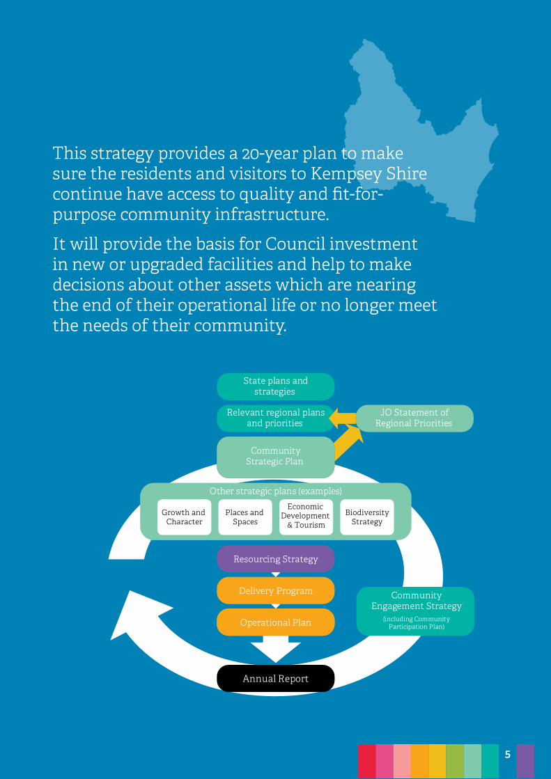
This strategy provides a 20-year plan to make sure the residents and visitors to Kempsey Shire continue have access to quality and fit-for-purpose community infrastructure.
It will provide the basis for Council investment in new or upgraded facilities and help to make decisions about other assets which are nearing the end of their operational life or no longer meet the needs of their community.
5
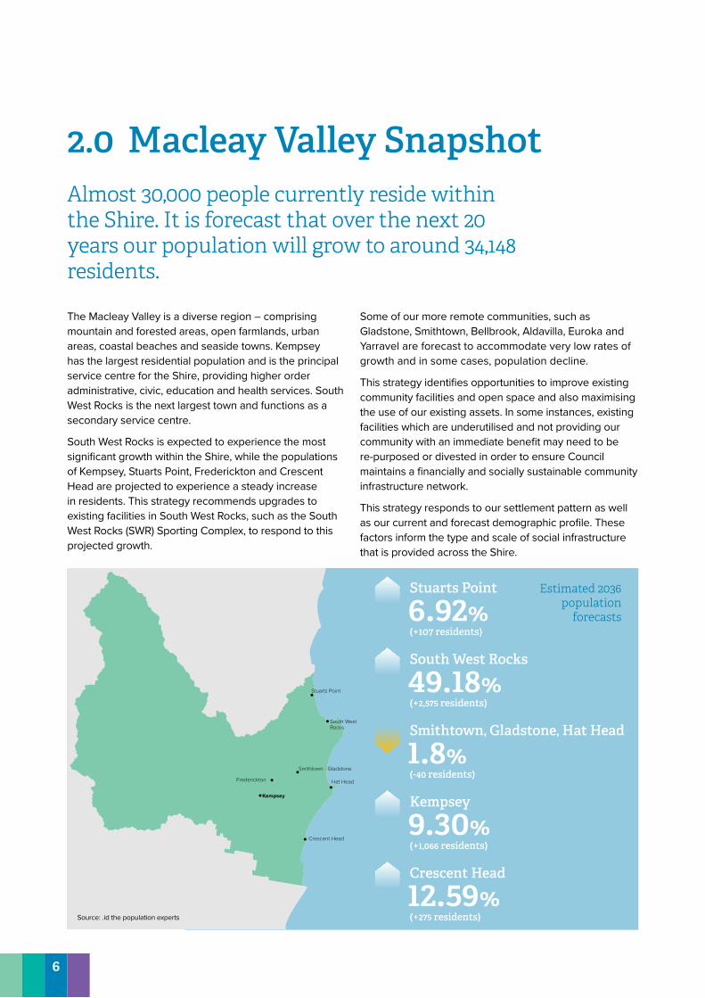
2.0 Macleay Valley SnapshotAlmost 30,000 people currently reside within the Shire. It is forecast that over the next 20 years our population will grow to around 34,148 residents.
The Macleay Valley is a diverse region – comprising mountain and forested areas, open farmlands, urban areas, coastal beaches and seaside towns. Kempsey has the largest residential population and is the principal service centre for the Shire, providing higher order administrative, civic, education and health services. South West Rocks is the next largest town and functions as a secondary service centre.
South West Rocks is expected to experience the most significant growth within the Shire, while the populations of Kempsey, Stuarts Point, Frederickton and Crescent Head are projected to experience a steady increase in residents. This strategy recommends upgrades to existing facilities in South West Rocks, such as the South West Rocks (SWR) Sporting Complex, to respond to this projected growth.
Some of our more remote communities, such as Gladstone, Smithtown, Bellbrook, Aldavilla, Euroka and Yarravel are forecast to accommodate very low rates of growth and in some cases, population decline.
This strategy identifies opportunities to improve existing community facilities and open space and also maximising the use of our existing assets. In some instances, existing facilities which are underutilised and not providing our community with an immediate benefit may need to be re-purposed or divested in order to ensure Council maintains a financially and socially sustainable community infrastructure network.
This strategy responds to our settlement pattern as well as our current and forecast demographic profile. These factors inform the type and scale of social infrastructure that is provided across the Shire.
Stuarts Point
Hat HeadFrederickton
Kempsey
Smithtown - Gladstone
Crescent Head
South WestRocks
Crescent Head
12.59%(+275 residents)
Kempsey
9.30%(+1,066 residents)
Smithtown, Gladstone, Hat Head
1.8%(-40 residents)
South West Rocks
49.18%(+2,575 residents)
Stuarts Point
6.92%(+107 residents)
Estimated 2036 population
forecasts
Source: .id the population experts
6
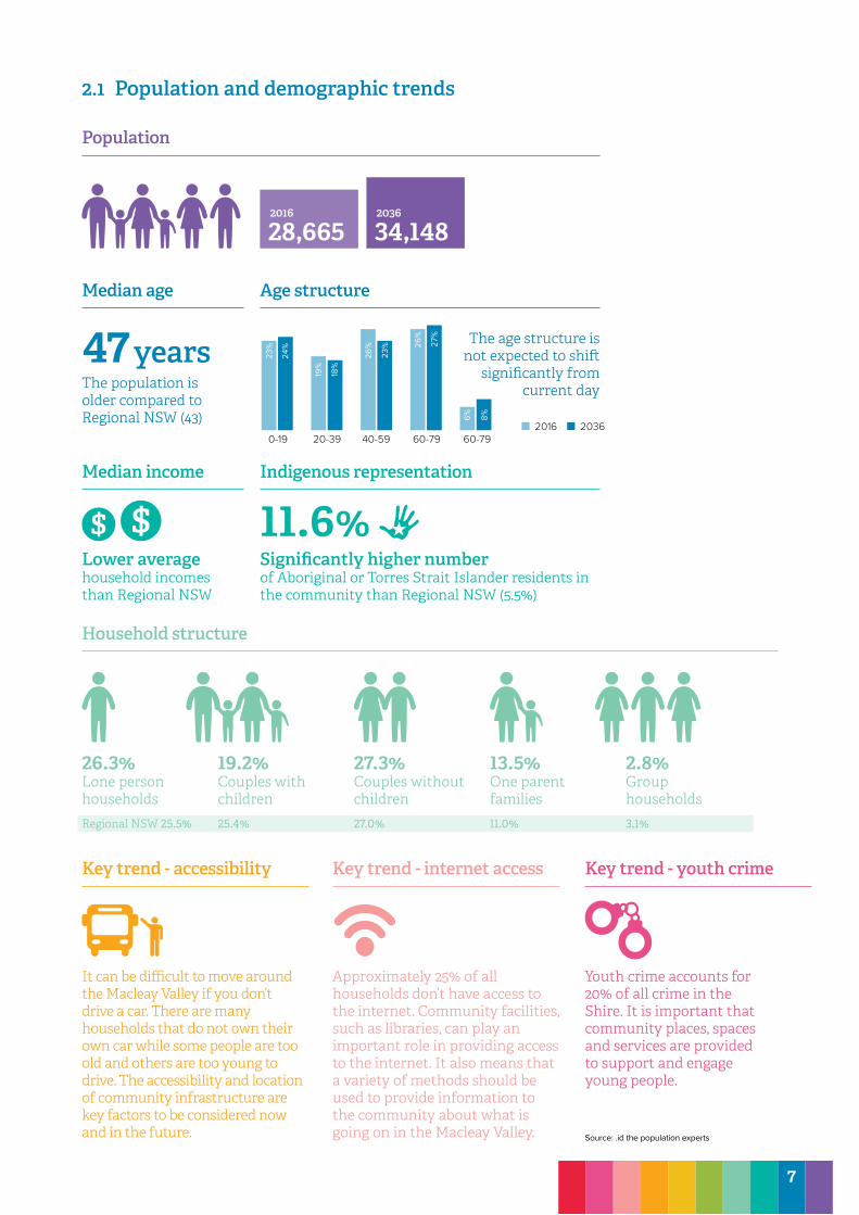
Youth crime accounts for 20% of all crime in the Shire. It is important that community places, spaces and services are provided to support and engage young people.
26.3%Lone person householdsRegional NSW 25.5%
19.2%Couples with children25.4%
27.3%Couples without children27.0%
13.5%One parent families11.0%
2.8%Group households3.1%
Household structure
Key trend - accessibility Key trend - internet access Key trend - youth crime
It can be difficult to move around the Macleay Valley if you don’t drive a car. There are many households that do not own their own car while some people are too old and others are too young to drive. The accessibility and location of community infrastructure are key factors to be considered now and in the future.
Approximately 25% of all households don’t have access to the internet. Community facilities, such as libraries, can play an important role in providing access to the internet. It also means that a variety of methods should be used to provide information to the community about what is going on in the Macleay Valley.
47 yearsThe population is older compared to Regional NSW (43)
11.6%Significantly higher number of Aboriginal or Torres Strait Islander residents in the community than Regional NSW (5.5%)
Lower average household incomes than Regional NSW
The age structure is not expected to shift
significantly from current day
Population
Median age Age structure
Median income Indigenous representation
2036
34,1482016
28,665
0-19 20-39 40-59 60-79 60-792016
23%
24%
19%
18%
23%
6% 8%
26% 27
%
26%
2036
2.1 Population and demographic trends
Source: .id the population experts
7
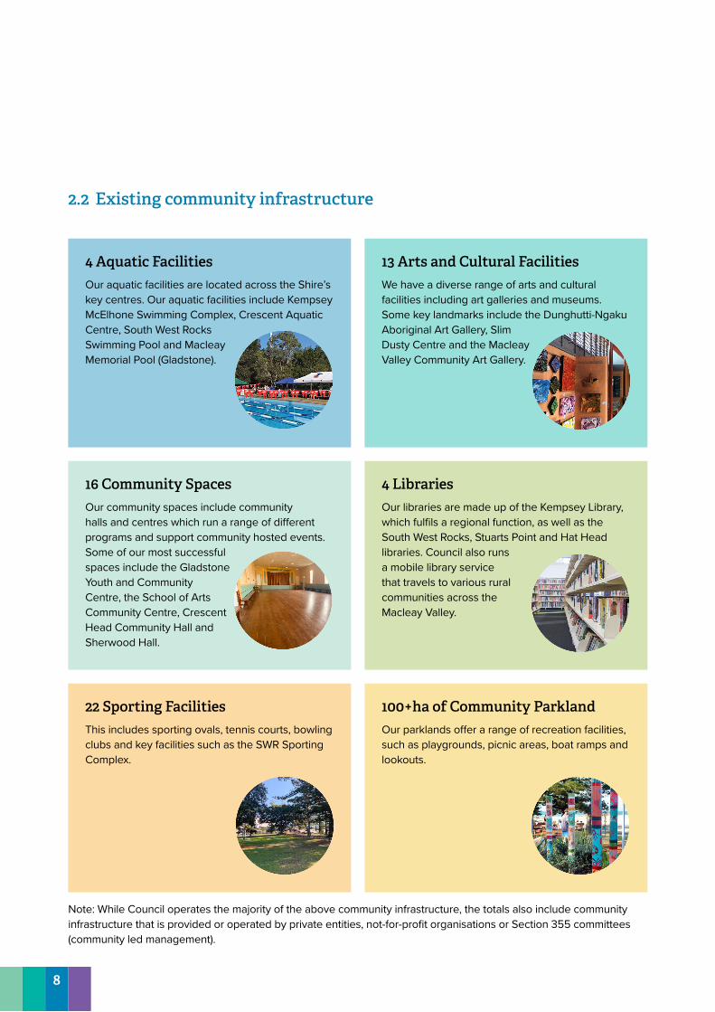
22 Sporting FacilitiesThis includes sporting ovals, tennis courts, bowling clubs and key facilities such as the SWR Sporting Complex.
4 LibrariesOur libraries are made up of the Kempsey Library, which fulfils a regional function, as well as the South West Rocks, Stuarts Point and Hat Head libraries. Council also runs a mobile library service that travels to various rural communities across the Macleay Valley.
100+ha of Community ParklandOur parklands offer a range of recreation facilities, such as playgrounds, picnic areas, boat ramps and lookouts.
2.2 Existing community infrastructure
4 Aquatic FacilitiesOur aquatic facilities are located across the Shire’s key centres. Our aquatic facilities include Kempsey McElhone Swimming Complex, Crescent Aquatic Centre, South West Rocks Swimming Pool and Macleay Memorial Pool (Gladstone).
16 Community SpacesOur community spaces include community halls and centres which run a range of different programs and support community hosted events. Some of our most successful spaces include the Gladstone Youth and Community Centre, the School of Arts Community Centre, Crescent Head Community Hall and Sherwood Hall.
13 Arts and Cultural FacilitiesWe have a diverse range of arts and cultural facilities including art galleries and museums. Some key landmarks include the Dunghutti-Ngaku Aboriginal Art Gallery, Slim Dusty Centre and the Macleay Valley Community Art Gallery.
Note: While Council operates the majority of the above community infrastructure, the totals also include community infrastructure that is provided or operated by private entities, not-for-profit organisations or Section 355 committees (community led management).
8
3.0 What we heardYou told us how you currently use community infrastructure, your priorities and the actions needed to deliver on your aspirations.
The strategy has been informed by a range of community and stakeholder feedback, obtained through workshops, interviews, online surveys and virtual Q&A sessions.
• 655 website visits• Over 100 attendees to community workshops• Over 100 online surveys• Over 40 students involved in a school workshop• Over 20 interviews with service providers, facility
managers and industry representatives You told us
The Macleay Valley is generally well serviced by community infrastructureThere is acknowledgement that the Macleay Valley has a good network of community infrastructure, open space and recreational facilities. Our links with Port Macquarie are also important, particularly to access spaces and services that are not available.
Open space is highly valuedOpen space supports health, wellbeing and sense of place. Foreshore areas are important places for relaxation and enjoyment. Local playgrounds are important for families and young people living in the area.
Information sharingThere is a need for better communication across the community. You want to know what is going on and how you can get involved in different community activities and initiatives.
More things for young people to doWe need more spaces and programs for young people across the Macleay Valley, that reflect their range of interests.
Access for all abilitiesWe need to make sure our community infrastructure and open spaces are accessible to people of all ages and abilities, particularly those living with a disability or with limited mobility.
A desire for more arts and cultural facilitiesThere is a strong community desire for more arts and cultural facilities throughout the Macleay Valley to showcase the work of our local artists.
Developing community pride There is a need to improve community pride across the Macleay Valley to build stronger relationships with place and each other.
Celebrate our strong Aboriginal cultureOur Shire has a strong and proud Aboriginal community. It is important that this is acknolwedged and reflected in our community facilities and public spaces.
9
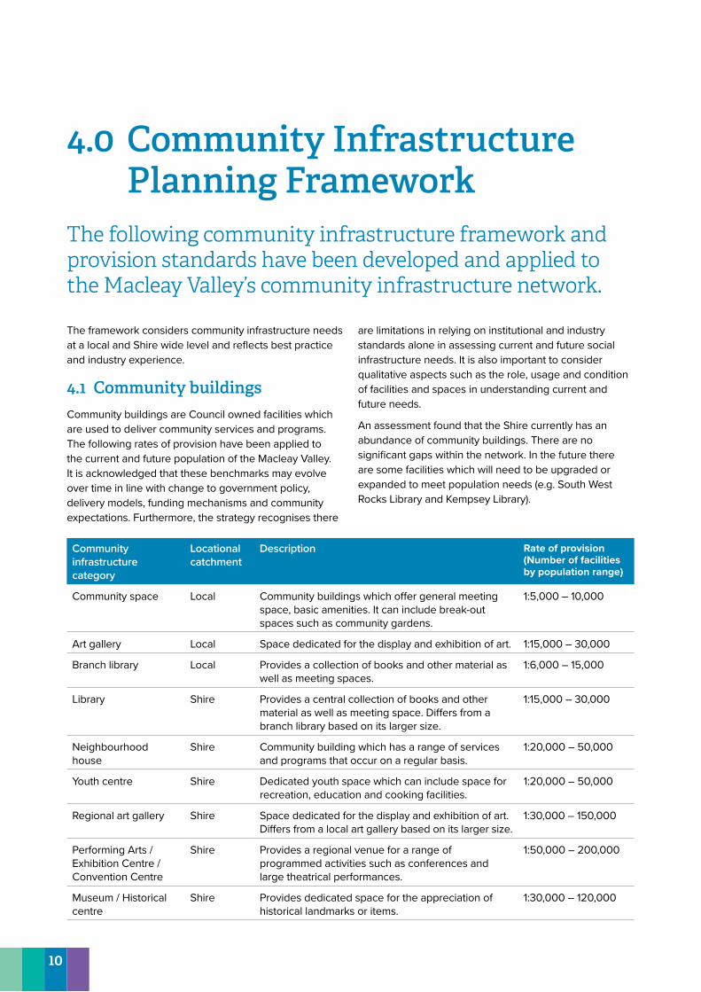
4.0 Community Infrastructure Planning Framework
The following community infrastructure framework and provision standards have been developed and applied to the Macleay Valley’s community infrastructure network.
The framework considers community infrastructure needs at a local and Shire wide level and reflects best practice and industry experience.
4.1 Community buildingsCommunity buildings are Council owned facilities which are used to deliver community services and programs. The following rates of provision have been applied to the current and future population of the Macleay Valley. It is acknowledged that these benchmarks may evolve over time in line with change to government policy, delivery models, funding mechanisms and community expectations. Furthermore, the strategy recognises there
are limitations in relying on institutional and industry standards alone in assessing current and future social infrastructure needs. It is also important to consider qualitative aspects such as the role, usage and condition of facilities and spaces in understanding current and future needs.
An assessment found that the Shire currently has an abundance of community buildings. There are no significant gaps within the network. In the future there are some facilities which will need to be upgraded or expanded to meet population needs (e.g. South West Rocks Library and Kempsey Library).
Community infrastructure category
Locational catchment
Description Rate of provision (Number of facilities by population range)
Community space Local Community buildings which offer general meeting space, basic amenities. It can include break-out spaces such as community gardens.
1:5,000 – 10,000
Art gallery Local Space dedicated for the display and exhibition of art. 1:15,000 – 30,000
Branch library Local Provides a collection of books and other material as well as meeting spaces.
1:6,000 – 15,000
Library Shire Provides a central collection of books and other material as well as meeting space. Differs from a branch library based on its larger size.
1:15,000 – 30,000
Neighbourhood house
Shire Community building which has a range of services and programs that occur on a regular basis.
1:20,000 – 50,000
Youth centre Shire Dedicated youth space which can include space for recreation, education and cooking facilities.
1:20,000 – 50,000
Regional art gallery Shire Space dedicated for the display and exhibition of art. Differs from a local art gallery based on its larger size.
1:30,000 – 150,000
Performing Arts / Exhibition Centre / Convention Centre
Shire Provides a regional venue for a range of programmed activities such as conferences and large theatrical performances.
1:50,000 – 200,000
Museum / Historical centre
Shire Provides dedicated space for the appreciation of historical landmarks or items.
1:30,000 – 120,000
10
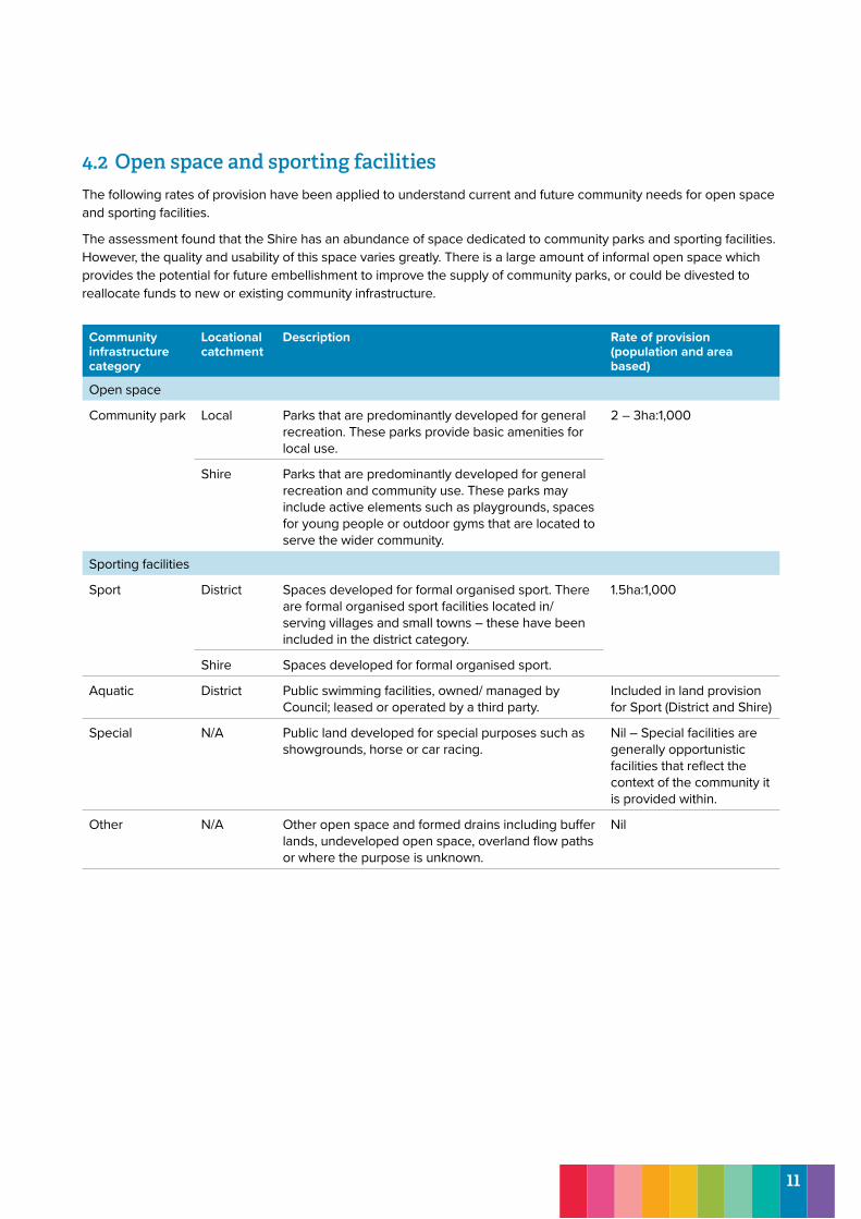
4.2 Open space and sporting facilitiesThe following rates of provision have been applied to understand current and future community needs for open space and sporting facilities.
The assessment found that the Shire has an abundance of space dedicated to community parks and sporting facilities. However, the quality and usability of this space varies greatly. There is a large amount of informal open space which provides the potential for future embellishment to improve the supply of community parks, or could be divested to reallocate funds to new or existing community infrastructure.
Community infrastructure category
Locational catchment
Description Rate of provision (population and area based)
Open space
Community park Local Parks that are predominantly developed for general recreation. These parks provide basic amenities for local use.
2 – 3ha:1,000
Shire Parks that are predominantly developed for general recreation and community use. These parks may include active elements such as playgrounds, spaces for young people or outdoor gyms that are located to serve the wider community.
Sporting facilities
Sport District Spaces developed for formal organised sport. There are formal organised sport facilities located in/ serving villages and small towns – these have been included in the district category.
1.5ha:1,000
Shire Spaces developed for formal organised sport.
Aquatic District Public swimming facilities, owned/ managed by Council; leased or operated by a third party.
Included in land provision for Sport (District and Shire)
Special N/A Public land developed for special purposes such as showgrounds, horse or car racing.
Nil – Special facilities are generally opportunistic facilities that reflect the context of the community it is provided within.
Other N/A Other open space and formed drains including buffer lands, undeveloped open space, overland flow paths or where the purpose is unknown.
Nil
11
4.3 Community infrastructure principlesThe following principles have been developed to guide the future planning, management and delivery of community infrastructure across the Macleay Valley. These principles provide further guidance to the provision rates to ensure that community places are engaging, functional, safe and activated.
Evidence-based decisionsCommunity infrastructure planning, management and delivery should be informed by a robust and up-to-date evidence base and founded on contemporary management practices, including regular audits and evaluation. It is also acknowledged that delivery models are changing and evolving – in the future there will be new ways of delivering services and meeting their social infrastructure needs.
Ongoing asset managementCommunity infrastructure will be effectively managed and maintained, supported by clear policies and guidelines associated with roles, responsibilities, standards of service and developer contributions. This will ensure the community has access to a high quality and functional network of spaces and places.
Accessible for allCommunity infrastructure needs to be designed for everyone and be accessible by all people, regardless of age, ability, socio-economic status or ethnicity. This is not a special requirement, for the benefit of only a minority of the population. It is a key foundation of good design. If a place is accessible, usable, convenient and a pleasure to use, everyone benefits.
Wherever possible, and as relevant, community infrastructure should be centrally located near commercial, retail and other community uses to improve its accessibility.
Diverse and place-basedProvide a range of open spaces, buildings and services that provide residents and visitors with a range of experiences which respond to the unique characteristics of a particular place or community. This will encourage people to spend more time in their community and help create local pride and a strong sense of identity.
Multi-functional and adaptableCommunity infrastructure should be designed to allow different user groups to enjoy and use the same space, and to allow the facility to evolve over time responding to changing community preferences and needs. User groups and service providers should be encouraged to share spaces in order to make efficient use of resources and infrastructure.
The community hub model is a contemporary model for delivering community infrastructure, which should be considered in the future planning and delivery of community places and spaces. It co-locates or integrates a range of community buildings, services and open space in a location. This model can provide improved accessibility, improved activation and use, supports cross-referral between services and can be more financially successful.
SafePeople should feel safe and secure when accessing community infrastructure across the Shire. Community infrastructure planning and design should reflect the Crime Prevention through Environmental Design principles (CPTED).
12
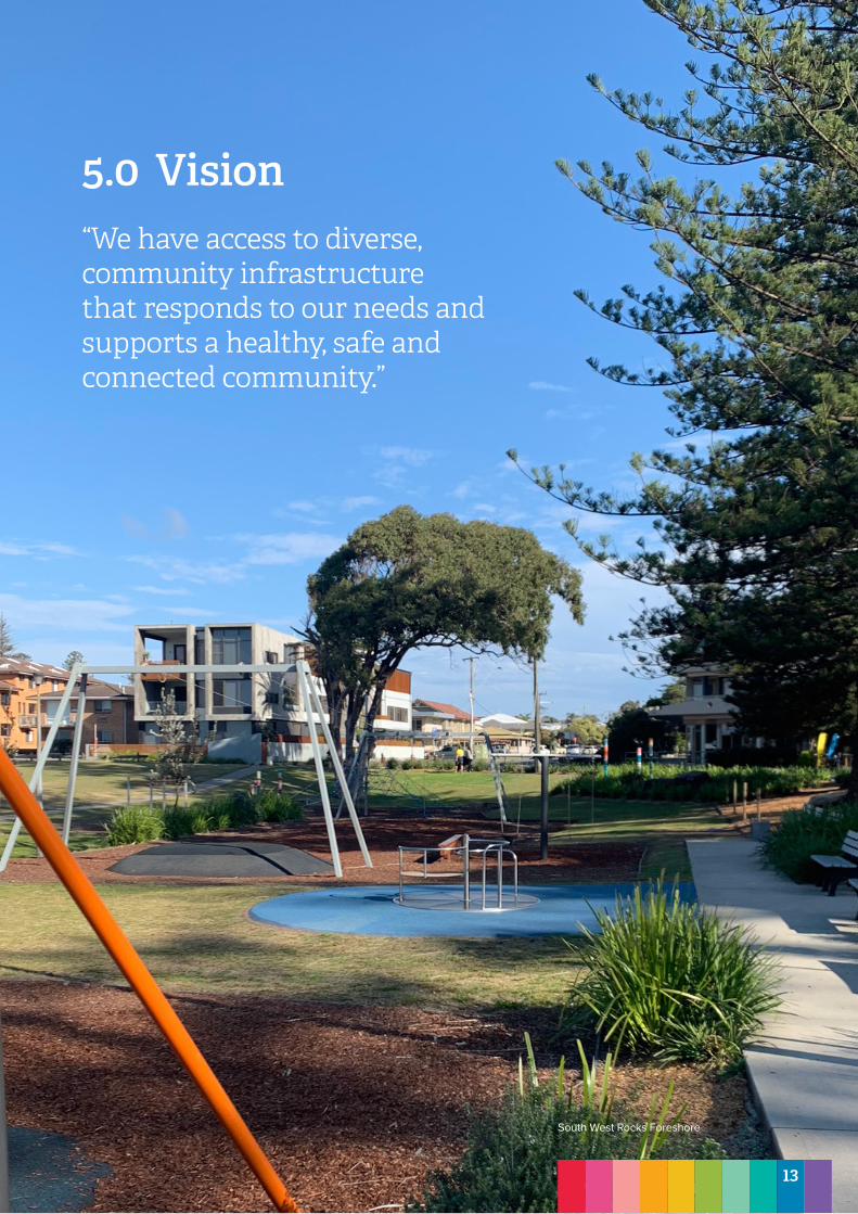
5.0 Vision “We have access to diverse, community infrastructure that responds to our needs and supports a healthy, safe and connected community.”
South West Rocks Foreshore
13
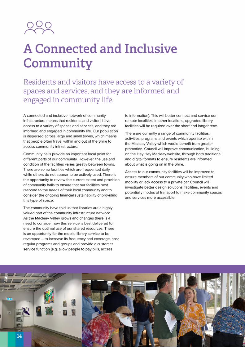
A Connected and Inclusive Community Residents and visitors have access to a variety of spaces and services, and they are informed and engaged in community life.
A connected and inclusive network of community infrastructure means that residents and visitors have access to a variety of spaces and services, and they are informed and engaged in community life. Our population is dispersed across large and small towns, which means that people often travel within and out of the Shire to access community infrastructure.
Community halls provide an important focal point for different parts of our community. However, the use and condition of the facilities varies greatly between towns. There are some facilities which are frequented daily, while others do not appear to be actively used. There is the opportunity to review the current extent and provision of community halls to ensure that our facilities best respond to the needs of their local community and to consider the ongoing financial sustainability of providing this type of space.
The community have told us that libraries are a highly valued part of the community infrastructure network. As the Macleay Valley grows and changes there is a need to consider how this service is best delivered to ensure the optimal use of our shared resources. There is an opportunity for the mobile library service to be revamped – to increase its frequency and coverage, host regular programs and groups and provide a customer service function (e.g. allow people to pay bills, access
to information). This will better connect and service our remote localities. In other locations, upgraded library facilities will be required over the short and longer term.
There are currently a range of community facilities, activities, programs and events which operate within the Macleay Valley which would benefit from greater promotion. Council will improve communication, building on the Hey Hey Macleay website, through both traditional and digital formats to ensure residents are informed about what is going on in the Shire.
Access to our community facilities will be improved to ensure members of our community who have limited mobility or lack access to a private car. Council will investigate better design solutions, facilities, events and potentially modes of transport to make community spaces and services more accessible.
14
Action Possible funding sources
Council’s role
Project timing and duration
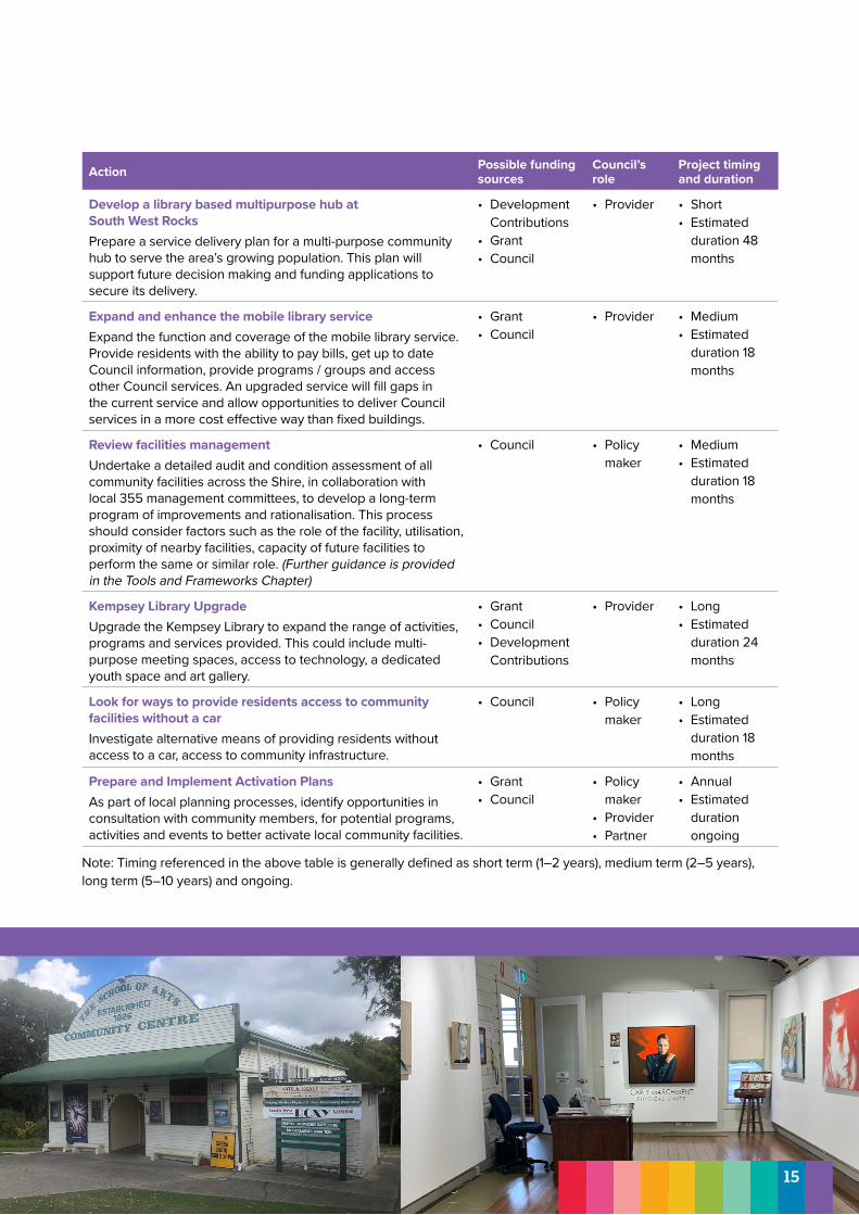
Develop a library based multipurpose hub at South West RocksPrepare a service delivery plan for a multi-purpose community hub to serve the area’s growing population. This plan will support future decision making and funding applications to secure its delivery.
• Development Contributions
• Grant• Council
• Provider • Short• Estimated
duration 48 months
Expand and enhance the mobile library serviceExpand the function and coverage of the mobile library service. Provide residents with the ability to pay bills, get up to date Council information, provide programs / groups and access other Council services. An upgraded service will fill gaps in the current service and allow opportunities to deliver Council services in a more cost effective way than fixed buildings.
• Grant• Council
• Provider • Medium• Estimated
duration 18 months
Review facilities managementUndertake a detailed audit and condition assessment of all community facilities across the Shire, in collaboration with local 355 management committees, to develop a long-term program of improvements and rationalisation. This process should consider factors such as the role of the facility, utilisation, proximity of nearby facilities, capacity of future facilities to perform the same or similar role. (Further guidance is provided in the Tools and Frameworks Chapter)
• Council • Policy maker
• Medium• Estimated
duration 18 months
Kempsey Library UpgradeUpgrade the Kempsey Library to expand the range of activities, programs and services provided. This could include multi-purpose meeting spaces, access to technology, a dedicated youth space and art gallery.
• Grant• Council• Development
Contributions
• Provider • Long• Estimated
duration 24 months
Look for ways to provide residents access to community facilities without a carInvestigate alternative means of providing residents without access to a car, access to community infrastructure.
• Council • Policy maker
• Long• Estimated
duration 18 months
Prepare and Implement Activation PlansAs part of local planning processes, identify opportunities in consultation with community members, for potential programs, activities and events to better activate local community facilities.
• Grant• Council
• Policy maker
• Provider• Partner
• Annual• Estimated
duration ongoing
Note: Timing referenced in the above table is generally defined as short term (1–2 years), medium term (2–5 years), long term (5–10 years) and ongoing.
15
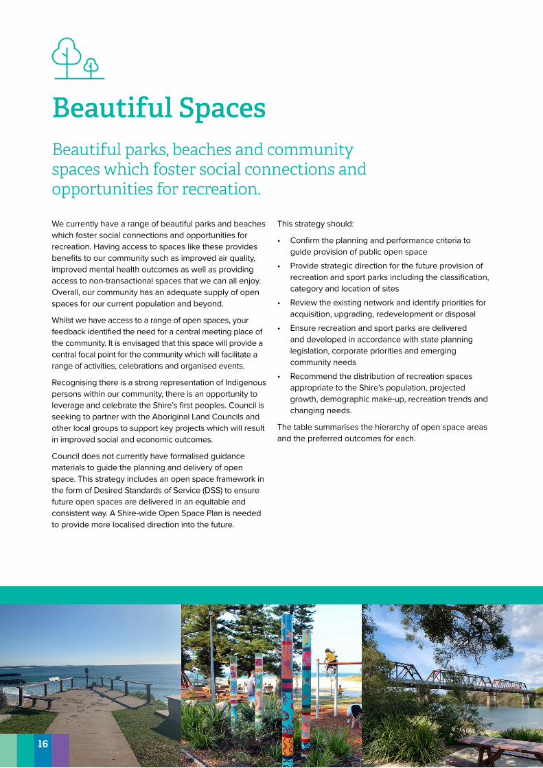
Beautiful SpacesBeautiful parks, beaches and community spaces which foster social connections and opportunities for recreation.
We currently have a range of beautiful parks and beaches which foster social connections and opportunities for recreation. Having access to spaces like these provides benefits to our community such as improved air quality, improved mental health outcomes as well as providing access to non-transactional spaces that we can all enjoy. Overall, our community has an adequate supply of open spaces for our current population and beyond.
Whilst we have access to a range of open spaces, your feedback identified the need for a central meeting place of the community. It is envisaged that this space will provide a central focal point for the community which will facilitate a range of activities, celebrations and organised events.
Recognising there is a strong representation of Indigenous persons within our community, there is an opportunity to leverage and celebrate the Shire’s first peoples. Council is seeking to partner with the Aboriginal Land Councils and other local groups to support key projects which will result in improved social and economic outcomes.
Council does not currently have formalised guidance materials to guide the planning and delivery of open space. This strategy includes an open space framework in the form of Desired Standards of Service (DSS) to ensure future open spaces are delivered in an equitable and consistent way. A Shire-wide Open Space Plan is needed to provide more localised direction into the future.
This strategy should:
• Confirm the planning and performance criteria to guide provision of public open space
• Provide strategic direction for the future provision of recreation and sport parks including the classification, category and location of sites
• Review the existing network and identify priorities for acquisition, upgrading, redevelopment or disposal
• Ensure recreation and sport parks are delivered and developed in accordance with state planning legislation, corporate priorities and emerging community needs
• Recommend the distribution of recreation spaces appropriate to the Shire’s population, projected growth, demographic make-up, recreation trends and changing needs.
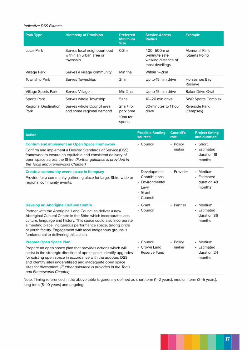
The table summarises the hierarchy of open space areas and the preferred outcomes for each.
16
Indicative DSS Extracts
Park Type Hierarchy of Provision Preferred Minimum Size
Service Access Radius
Example
Local Park Serves local neighbourhood within an urban area or township
0.3ha 400–500m or 5-minute safe walking distance of most dwellings
Memorial Park (Stuarts Point)
Village Park Serves a village community Min 1ha Within 1–2km
Township Park Serves Townships 2ha Up to-15 min drive Horseshoe Bay Reserve
Village Sports Park Serves Village Min 2ha Up to-15 min drive Baker Drive Oval
Sports Park Serves whole Township 5+ha 10–20 min drive SWR Sports Complex
Regional Destination Park
Serves whole Council area and some regional demand
2ha + for park area10ha for sports
30-minutes to 1 hour drive
Riverside Park (Kempsey)
Action Possible funding sources
Council’s role
Project timing and duration
Confirm and implement an Open Space FrameworkConfirm and implement a Desired Standards of Service (DSS) framework to ensure an equitable and consistent delivery of open space across the Shire. (Further guidance is provided in the Tools and Frameworks Chapter)
• Council • Policy maker
• Short• Estimated
duration 18 months
Create a community event space in KempseyProvide for a community gathering place for large, Shire-wide or regional community events.
• Development Contributions
• Environmental Levy
• Grant• Council
• Provider • Medium • Estimated
duration 48 months
Develop an Aboriginal Cultural CentrePartner with the Aboriginal Land Council to deliver a new Aboriginal Cultural Centre in the Shire which incorporates arts, culture, language and history. This space could also incorporate a meeting place, indigenous performance space, talking circle or youth facility. Engagement with local indigenous groups is fundamental to delivering this action.
• Grant• Council
• Partner • Medium • Estimated
duration 36 months
Prepare Open Space PlanPrepare an open space plan that provides actions which will assist in the strategic direction of open space, identify upgrades for existing open space in accordance with the adopted DSS and identify sites underutilised and inadequate open space sites for divestment. (Further guidance is provided in the Tools and Frameworks Chapter)
• Council• Crown Land
Reserve Fund
• Policy maker
• Medium• Estimated
duration 24 months
Note: Timing referenced in the above table is generally defined as short term (1–2 years), medium term (2–5 years), long term (5–10 years) and ongoing.
17
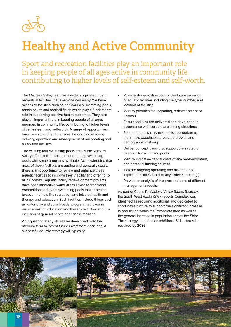
Healthy and Active Community Sport and recreation facilities play an important role in keeping people of all ages active in community life, contributing to higher levels of self-esteem and self-worth.
The Macleay Valley features a wide range of sport and recreation facilities that everyone can enjoy. We have access to facilities such as golf courses, swimming pools, tennis courts and football fields which play a fundamental role in supporting positive health outcomes. They also play an important role in keeping people of all ages engaged in community life, contributing to higher levels of self-esteem and self-worth. A range of opportunities have been identified to ensure the ongoing efficient delivery, operation and management of our sporting and recreation facilities.
The existing four swimming pools across the Macleay Valley offer similar traditional outdoor lap swimming pools with some programs available. Acknowledging that most of these facilities are ageing and generally costly, there is an opportunity to review and enhance these aquatic facilities to improve their viability and offering to all. Successful aquatic facility redevelopment projects have seen innovative water areas linked to traditional competition and event swimming pools that appeal to broader markets like recreation and leisure, health and therapy and education. Such facilities include things such as water play and splash pads, programmable warm water areas for education and therapy activities and the inclusion of general health and fitness facilities.
An Aquatic Strategy should be developed over the medium term to inform future investment decisions. A successful aquatic strategy will typically:
• Provide strategic direction for the future provision of aquatic facilities including the type, number, and location of facilities
• Identify priorities for upgrading, redevelopment or disposal
• Ensure facilities are delivered and developed in accordance with corporate planning directions
• Recommend a facility mix that is appropriate to the Shire’s population, projected growth, and demographic make-up
• Deliver concept plans that support the strategic direction for swimming pools
• Identify indicative capital costs of any redevelopment, and potential funding sources
• Indicate ongoing operating and maintenance implications for Council of any redevelopment(s)
• Provide an analysis of the pros and cons of different management models.
As part of Council’s Macleay Valley Sports Strategy, the South West Rocks (SWR) Sports Complex was identified as requiring additional land dedicated to sport infrastructure to support the significant increase in population within the immediate area as well as the general increase in population across the Shire. The strategy identified an additional 6.1 hectares is required by 2036.
18
Action Possible funding sources
Council’s role
Project timing and duration
Prepare Aquatic StrategyPrepare an Aquatic Strategy that considers the viability of existing public pools and the future needs for the community. (Further guidance is provided in the Tools and Frameworks Chapter)
• Grant• Council• Development
Contributions
• Provider • Short• Estimated
duration 18 months
Upgrade Verge Street Ovals and Services Park Increase the capability for a range of sports and events across.
• Grant• Council• Development
Contributions
• Provider • Short• Estimated
duration 36 months
Expand the SWR Sports ComplexExpand the SWR Sports Complex, as per the Macleay Valley Sports Strategy, and improve the current facilities.
• Grant• Council• Development
Contributions
• Partner• Provider
• Medium• Estimated
duration 36 months
Note: Timing referenced in the above table is generally defined as short term (1–2 years), medium term (2–5 years), long term (5–10 years) and ongoing.
19
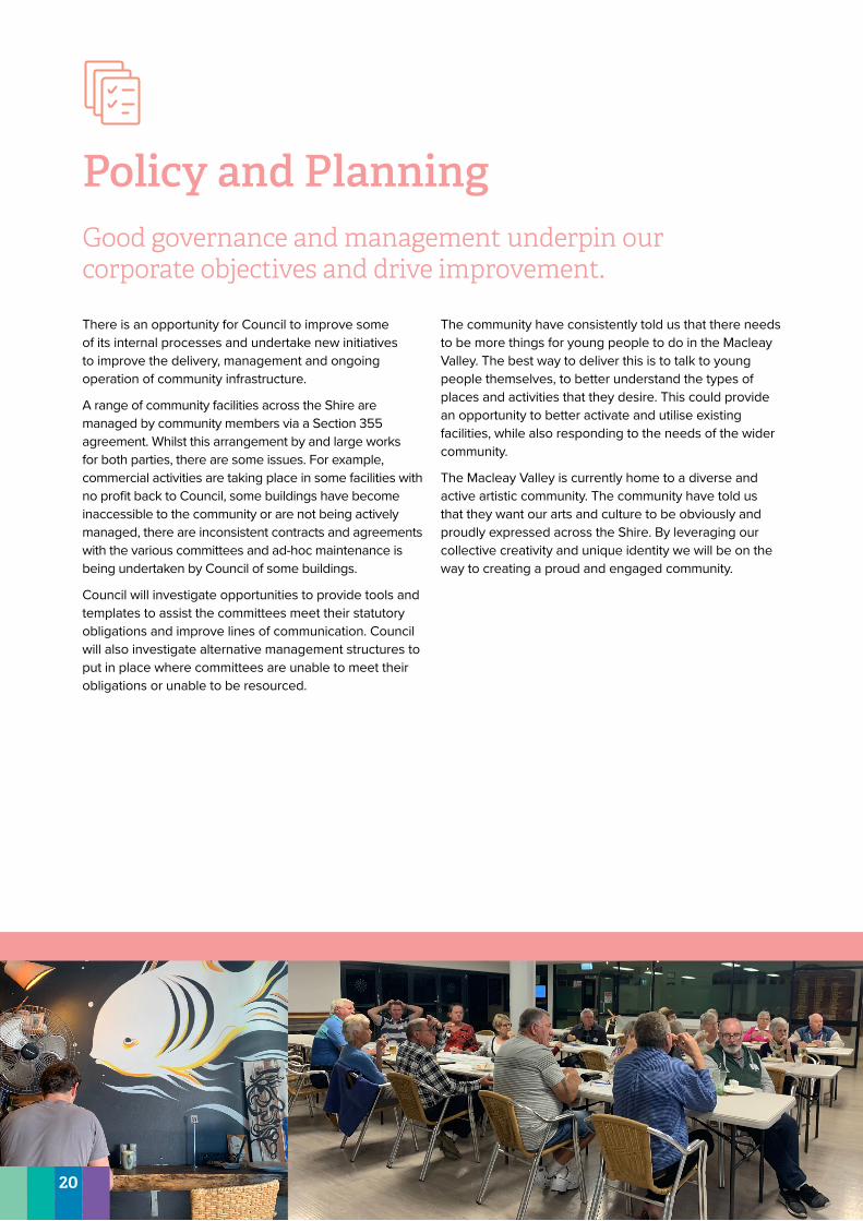
Policy and Planning Good governance and management underpin our corporate objectives and drive improvement.
There is an opportunity for Council to improve some of its internal processes and undertake new initiatives to improve the delivery, management and ongoing operation of community infrastructure.
A range of community facilities across the Shire are managed by community members via a Section 355 agreement. Whilst this arrangement by and large works for both parties, there are some issues. For example, commercial activities are taking place in some facilities with no profit back to Council, some buildings have become inaccessible to the community or are not being actively managed, there are inconsistent contracts and agreements with the various committees and ad-hoc maintenance is being undertaken by Council of some buildings.
Council will investigate opportunities to provide tools and templates to assist the committees meet their statutory obligations and improve lines of communication. Council will also investigate alternative management structures to put in place where committees are unable to meet their obligations or unable to be resourced.
The community have consistently told us that there needs to be more things for young people to do in the Macleay Valley. The best way to deliver this is to talk to young people themselves, to better understand the types of places and activities that they desire. This could provide an opportunity to better activate and utilise existing facilities, while also responding to the needs of the wider community.
The Macleay Valley is currently home to a diverse and active artistic community. The community have told us that they want our arts and culture to be obviously and proudly expressed across the Shire. By leveraging our collective creativity and unique identity we will be on the way to creating a proud and engaged community.
20
Action Possible funding sources
Council’s role
Project timing and duration
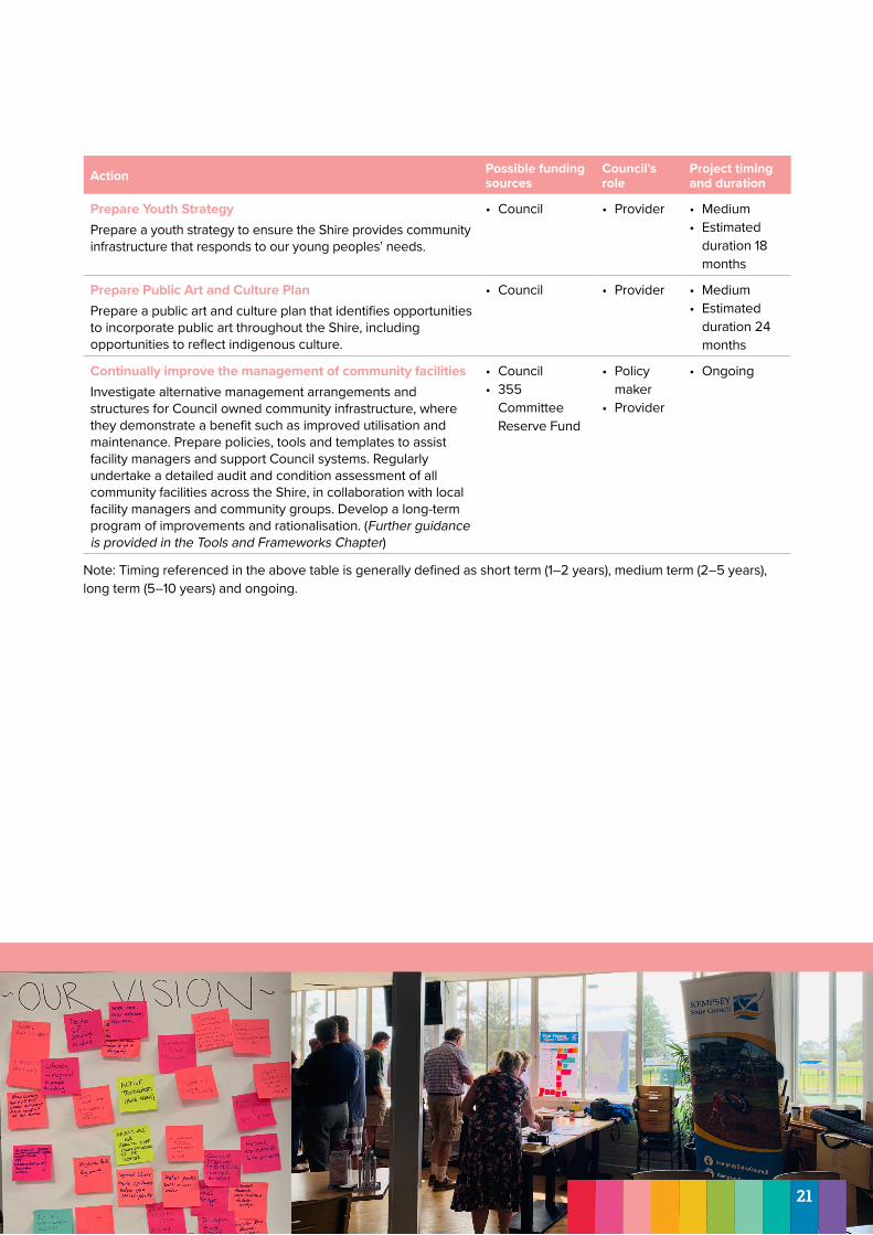
Prepare Youth StrategyPrepare a youth strategy to ensure the Shire provides community infrastructure that responds to our young peoples’ needs.
• Council • Provider • Medium• Estimated
duration 18 months
Prepare Public Art and Culture PlanPrepare a public art and culture plan that identifies opportunities to incorporate public art throughout the Shire, including opportunities to reflect indigenous culture.
• Council • Provider • Medium• Estimated
duration 24 months
Continually improve the management of community facilitiesInvestigate alternative management arrangements and structures for Council owned community infrastructure, where they demonstrate a benefit such as improved utilisation and maintenance. Prepare policies, tools and templates to assist facility managers and support Council systems. Regularly undertake a detailed audit and condition assessment of all community facilities across the Shire, in collaboration with local facility managers and community groups. Develop a long-term program of improvements and rationalisation. (Further guidance is provided in the Tools and Frameworks Chapter)
• Council • 355
Committee Reserve Fund
• Policy maker
• Provider
• Ongoing
Note: Timing referenced in the above table is generally defined as short term (1–2 years), medium term (2–5 years), long term (5–10 years) and ongoing.
21
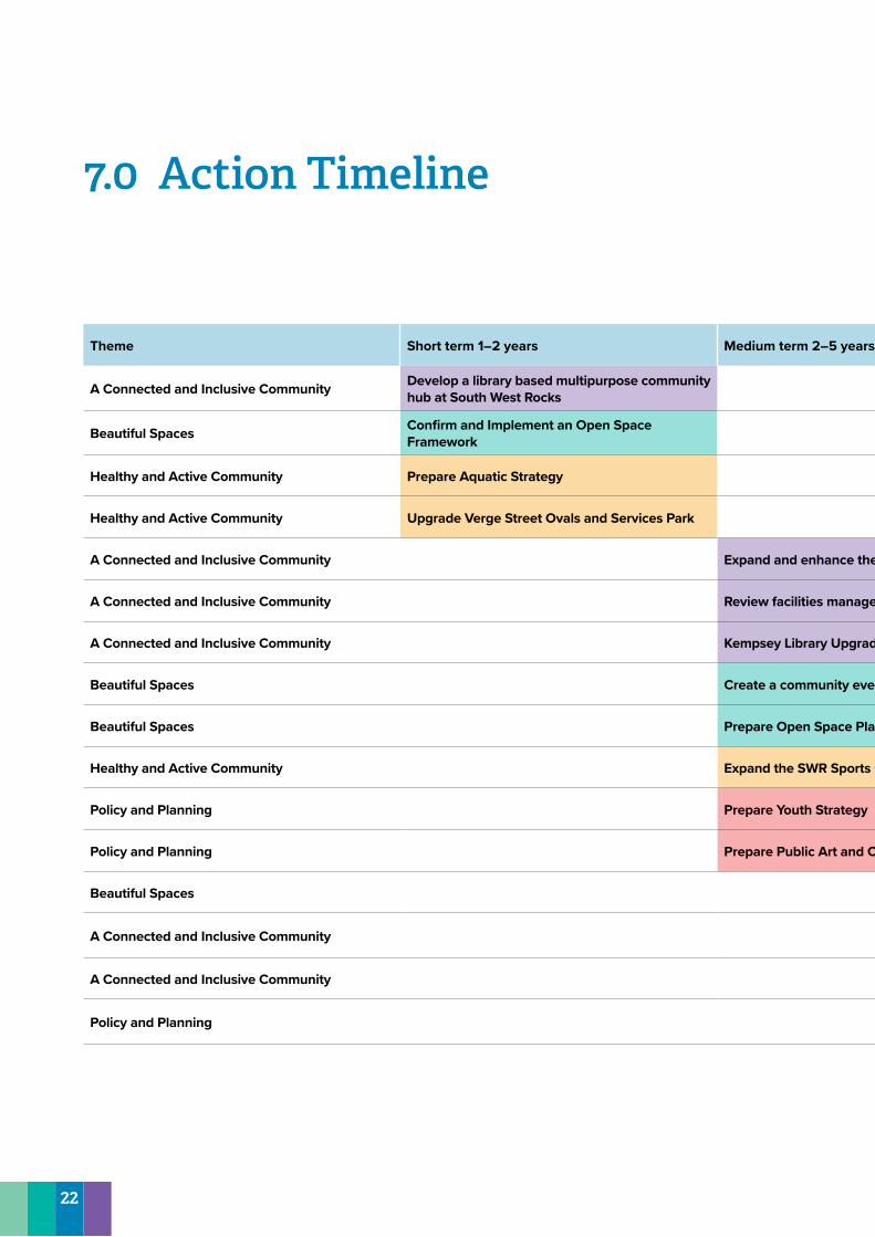
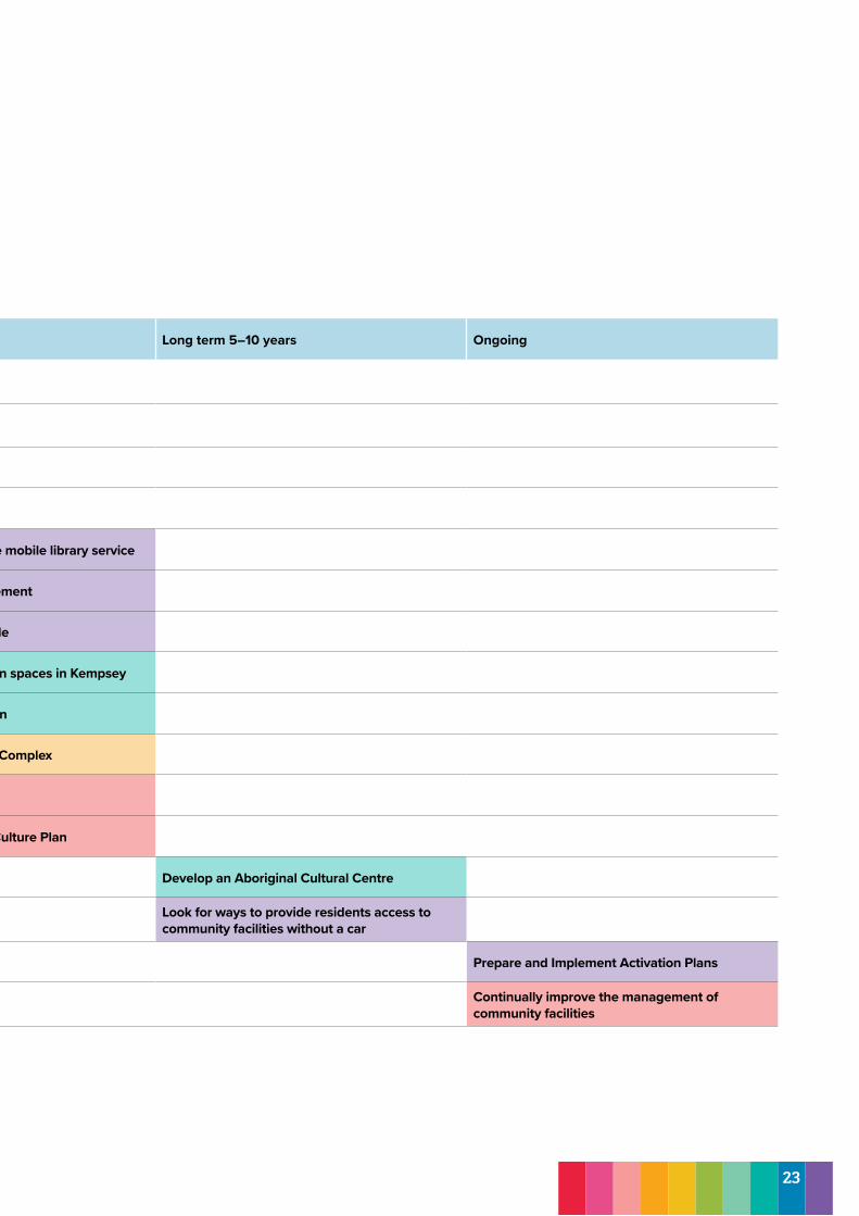
7.0 Action Timeline
Theme Short term 1–2 years Medium term 2–5 years Long term 5–10 years Ongoing
A Connected and Inclusive Community Develop a library based multipurpose community hub at South West Rocks
Beautiful Spaces Confirm and Implement an Open Space Framework
Healthy and Active Community Prepare Aquatic Strategy
Healthy and Active Community Upgrade Verge Street Ovals and Services Park
A Connected and Inclusive Community Expand and enhance the mobile library service
A Connected and Inclusive Community Review facilities management
A Connected and Inclusive Community Kempsey Library Upgrade
Beautiful Spaces Create a community even spaces in Kempsey
Beautiful Spaces Prepare Open Space Plan
Healthy and Active Community Expand the SWR Sports Complex
Policy and Planning Prepare Youth Strategy
Policy and Planning Prepare Public Art and Culture Plan
Beautiful Spaces Develop an Aboriginal Cultural Centre
A Connected and Inclusive Community Look for ways to provide residents access to community facilities without a car
A Connected and Inclusive Community Prepare and Implement Activation Plans
Policy and Planning Continually improve the management of community facilities
22
Theme Short term 1–2 years Medium term 2–5 years Long term 5–10 years Ongoing
A Connected and Inclusive Community Develop a library based multipurpose community hub at South West Rocks
Beautiful Spaces Confirm and Implement an Open Space Framework
Healthy and Active Community Prepare Aquatic Strategy
Healthy and Active Community Upgrade Verge Street Ovals and Services Park
A Connected and Inclusive Community Expand and enhance the mobile library service
A Connected and Inclusive Community Review facilities management
A Connected and Inclusive Community Kempsey Library Upgrade
Beautiful Spaces Create a community even spaces in Kempsey
Beautiful Spaces Prepare Open Space Plan
Healthy and Active Community Expand the SWR Sports Complex
Policy and Planning Prepare Youth Strategy
Policy and Planning Prepare Public Art and Culture Plan
Beautiful Spaces Develop an Aboriginal Cultural Centre
A Connected and Inclusive Community Look for ways to provide residents access to community facilities without a car
A Connected and Inclusive Community Prepare and Implement Activation Plans
Policy and Planning Continually improve the management of community facilities
23
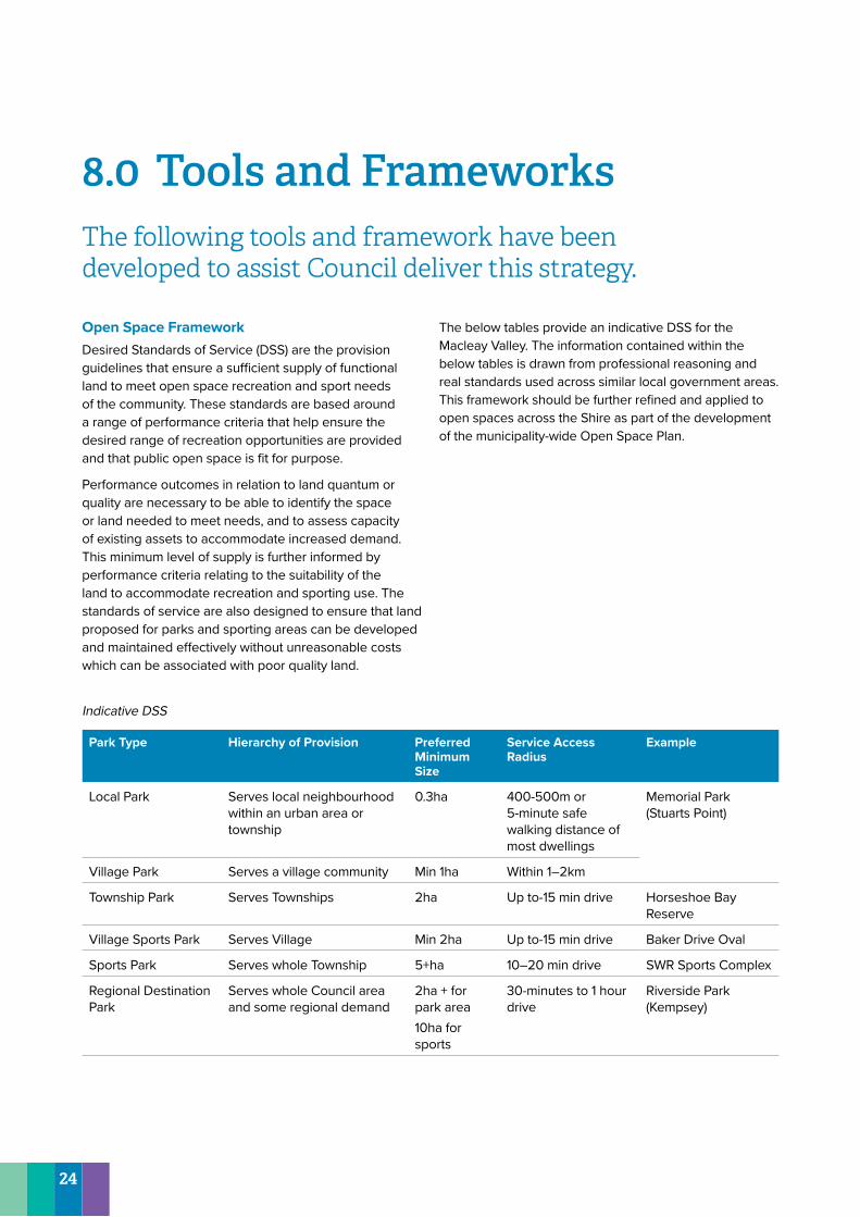
8.0 Tools and FrameworksThe following tools and framework have been developed to assist Council deliver this strategy.
Open Space FrameworkDesired Standards of Service (DSS) are the provision guidelines that ensure a sufficient supply of functional land to meet open space recreation and sport needs of the community. These standards are based around a range of performance criteria that help ensure the desired range of recreation opportunities are provided and that public open space is fit for purpose.
Performance outcomes in relation to land quantum or quality are necessary to be able to identify the space or land needed to meet needs, and to assess capacity of existing assets to accommodate increased demand. This minimum level of supply is further informed by performance criteria relating to the suitability of the land to accommodate recreation and sporting use. The standards of service are also designed to ensure that land proposed for parks and sporting areas can be developed and maintained effectively without unreasonable costs which can be associated with poor quality land.
The below tables provide an indicative DSS for the Macleay Valley. The information contained within the below tables is drawn from professional reasoning and real standards used across similar local government areas. This framework should be further refined and applied to open spaces across the Shire as part of the development of the municipality-wide Open Space Plan.
Indicative DSS
Park Type Hierarchy of Provision Preferred Minimum Size
Service Access Radius
Example
Local Park Serves local neighbourhood within an urban area or township
0.3ha 400-500m or 5-minute safe walking distance of most dwellings
Memorial Park (Stuarts Point)
Village Park Serves a village community Min 1ha Within 1–2km
Township Park Serves Townships 2ha Up to-15 min drive Horseshoe Bay Reserve
Village Sports Park Serves Village Min 2ha Up to-15 min drive Baker Drive Oval
Sports Park Serves whole Township 5+ha 10–20 min drive SWR Sports Complex
Regional Destination Park
Serves whole Council area and some regional demand
2ha + for park area10ha for sports
30-minutes to 1 hour drive
Riverside Park (Kempsey)
24
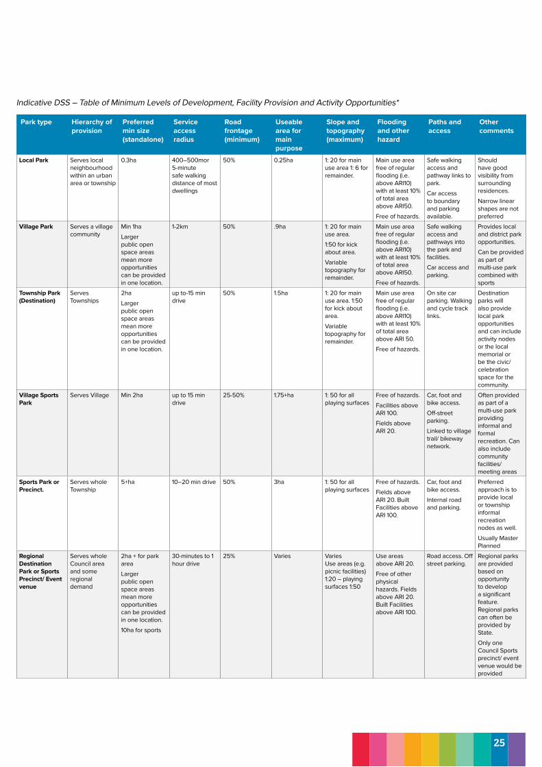
Indicative DSS – Table of Minimum Levels of Development, Facility Provision and Activity Opportunities*
Park type Hierarchy of provision
Preferred min size (standalone)
Service access radius
Road frontage (minimum)
Useable area for main purpose
Slope and topography (maximum)
Flooding and other hazard
Paths and access
Other comments
Local Park Serves local neighbourhood within an urban area or township
0.3ha 400–500mor 5-minute safe walking distance of most dwellings
50% 0.25ha 1: 20 for main use area 1: 6 for remainder.
Main use area free of regular flooding (i.e. above ARI10) with at least 10% of total area above ARI50. Free of hazards.
Safe walking access and pathway links to park. Car access to boundary and parking available.
Should have good visibility from surrounding residences. Narrow linear shapes are not preferred
Village Park Serves a village community
Min 1haLarger public open space areas mean more opportunities can be provided in one location.
1-2km 50% .9ha 1: 20 for main use area. 1:50 for kick about area. Variable topography for remainder.
Main use area free of regular flooding (i.e. above ARI10) with at least 10% of total area above ARI50. Free of hazards.
Safe walking access and pathways into the park and facilities. Car access and parking.
Provides local and district park opportunities. Can be provided as part of multi-use park combined with sports
Township Park (Destination)
Serves Townships
2haLarger public open space areas mean more opportunities can be provided in one location.
up to-15 min drive
50% 1.5ha 1: 20 for main use area. 1:50 for kick about area. Variable topography for remainder.
Main use area free of regular flooding (i.e. above ARI10) with at least 10% of total area above ARI 50.Free of hazards.
On site car parking. Walking and cycle track links.
Destination parks will also provide local park opportunities and can include activity nodes or the local memorial or be the civic/ celebration space for the community.
Village Sports Park
Serves Village Min 2ha up to 15 min drive
25-50% 1.75+ha 1: 50 for all playing surfaces
Free of hazards. Facilities above ARI 100. Fields above ARI 20.
Car, foot and bike access. Off-street parking. Linked to village trail/ bikeway network.
Often provided as part of a multi-use park providing informal and formal recreation. Can also include community facilities/ meeting areas
Sports Park or Precinct.
Serves whole Township
5+ha 10–20 min drive 50% 3ha 1: 50 for all playing surfaces
Free of hazards. Fields above ARI 20. Built Facilities above ARI 100.
Car, foot and bike access. Internal road and parking.
Preferred approach is to provide local or township informal recreation nodes as well. Usually Master Planned
Regional Destination Park or Sports Precinct/ Event venue
Serves whole Council area and some regional demand
2ha + for park areaLarger public open space areas mean more opportunities can be provided in one location.10ha for sports
30-minutes to 1 hour drive
25% Varies Varies Use areas (e.g. picnic facilities) 1:20 – playing surfaces 1:50
Use areas above ARI 20. Free of other physical hazards. Fields above ARI 20. Built Facilities above ARI 100.
Road access. Off street parking.
Regional parks are provided based on opportunity to develop a significant feature. Regional parks can often be provided by State. Only one Council Sports precinct/ event venue would be provided
25
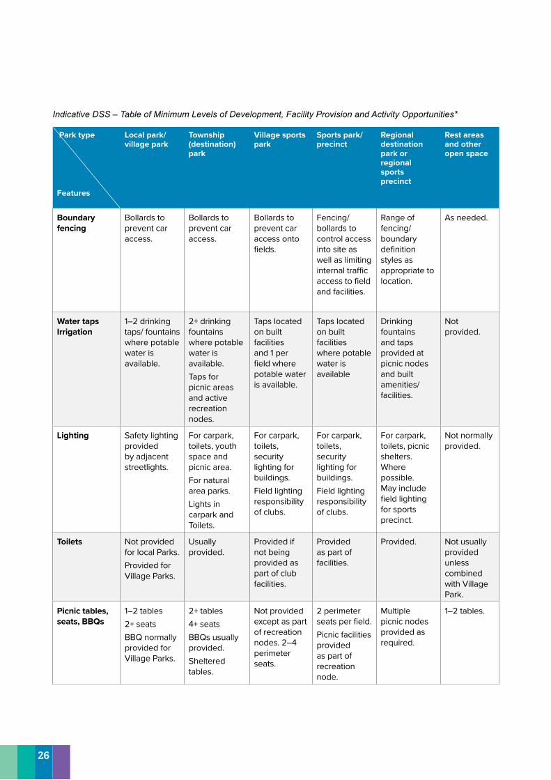
Indicative DSS – Table of Minimum Levels of Development, Facility Provision and Activity Opportunities*
Park type
Features
Local park/ village park
Township (destination) park
Village sports park
Sports park/ precinct
Regional destination park or regional sports precinct
Rest areas and other open space
Boundary fencing
Bollards to prevent car access.
Bollards to prevent car access.
Bollards to prevent car access onto fields.
Fencing/ bollards to control access into site as well as limiting internal traffic access to field and facilities.
Range of fencing/ boundary definition styles as appropriate to location.
As needed.
Water taps Irrigation
1–2 drinking taps/ fountains where potable water is available.
2+ drinking fountains where potable water is available. Taps for picnic areas and active recreation nodes.
Taps located on built facilities and 1 per field where potable water is available.
Taps located on built facilities where potable water is available
Drinking fountains and taps provided at picnic nodes and built amenities/ facilities.
Not provided.
Lighting Safety lighting provided by adjacent streetlights.
For carpark, toilets, youth space and picnic area. For natural area parks. Lights in carpark and Toilets.
For carpark, toilets, security lighting for buildings. Field lighting responsibility of clubs.
For carpark, toilets, security lighting for buildings. Field lighting responsibility of clubs.
For carpark, toilets, picnic shelters. Where possible. May include field lighting for sports precinct.
Not normally provided.
Toilets Not provided for local Parks. Provided for Village Parks.
Usually provided.
Provided if not being provided as part of club facilities.
Provided as part of facilities.
Provided. Not usually provided unless combined with Village Park.
Picnic tables, seats, BBQs
1–2 tables 2+ seats BBQ normally provided for Village Parks.
2+ tables 4+ seats BBQs usually provided. Sheltered tables.
Not provided except as part of recreation nodes. 2–4 perimeter seats.
2 perimeter seats per field. Picnic facilities provided as part of recreation node.
Multiple picnic nodes provided as required.
1–2 tables.
26
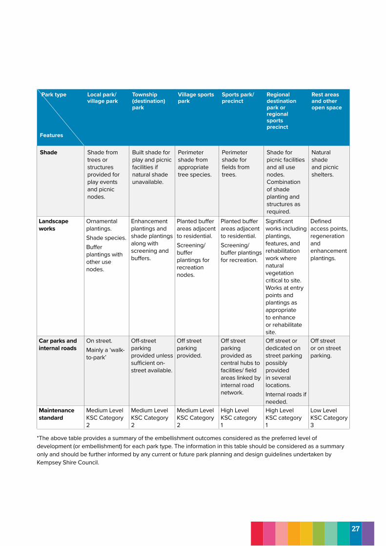
Park type
Features
Local park/ village park
Township (destination) park
Village sports park
Sports park/ precinct
Regional destination park or regional sports precinct
Rest areas and other open space
Shade Shade from trees or structures provided for play events and picnic nodes.
Built shade for play and picnic facilities if natural shade unavailable.
Perimeter shade from appropriate tree species.
Perimeter shade for fields from trees.
Shade for picnic facilities and all use nodes. Combination of shade planting and structures as required.
Natural shade and picnic shelters.
Landscape works
Ornamental plantings. Shade species. Buffer plantings with other use nodes.
Enhancement plantings and shade plantings along with screening and buffers.
Planted buffer areas adjacent to residential. Screening/ buffer plantings for recreation nodes.
Planted buffer areas adjacent to residential. Screening/ buffer plantings for recreation.
Significant works including plantings, features, and rehabilitation work where natural vegetation critical to site. Works at entry points and plantings as appropriate to enhance or rehabilitate site.
Defined access points, regeneration and enhancement plantings.
Car parks and internal roads
On street. Mainly a ‘walk-to-park’
Off-street parking provided unless sufficient on-street available.
Off street parking provided.
Off street parking provided as central hubs to facilities/ field areas linked by internal road network.
Off street or dedicated on street parking possibly provided in several locations. Internal roads if needed.
Off street or on street parking.
Maintenance standard
Medium Level KSC Category 2
Medium Level KSC Category 2
Medium Level KSC Category 2
High Level KSC category 1
High Level KSC category 1
Low Level KSC Category 3
*The above table provides a summary of the embellishment outcomes considered as the preferred level of development (or embellishment) for each park type. The information in this table should be considered as a summary only and should be further informed by any current or future park planning and design guidelines undertaken by Kempsey Shire Council.
27
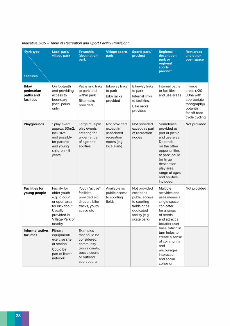
Indicative DSS – Table of Recreation and Sport Facility Provision^
Park type
Features
Local park/ village park
Township (destination) park
Village sports park
Sports park/ precinct
Regional destination park or regional sports precinct
Rest areas and other open space
Bike/ pedestrian paths and facilities
On footpath and providing access to boundary (local parks only)
Paths and links to park and within park Bike racks provided
Bikeway links to park Bike racks provided
Bikeway links to park Internal links to facilities. Bike racks provided
Internal paths to facilities and use areas
In large areas (>20-30ha with appropriate topography), potential for off-road cycle cycling
Playgrounds 1 play event, approx. 50m2; inclusive and possibly for parents and young children (<5 years)
Large multiple play events catering for wider range of age and abilities
Not provided except in associated recreation nodes (e.g. local Park)
Not provided except as part of recreation nodes
Sometimes provided as part of picnic and use area. Depends on the other opportunities at park; could be large destination play area, range of ages and abilities included.
Not provided
Facilities for young people
Facility for older youth e.g. ½ court or open area for kickabout. Usually provided in Village Park or nearby
Youth “active” facilities provided e.g. ½ court, bike tracks, youth space etc
Available as public access to sporting fields
Not provided except as public access to sporting fields or as dedicated facility (e.g. skate park)
Multiple activities and uses means a single space can cater for a range of needs and attract a broader user base, which in turn helps to create a sense of community and encourages interaction and social cohesion
Not provided
Informal active facilities
Fitness equipment/ exercise site or stationCould be part of linear network
Examples that could be considered: community tennis courts, bocce courts or outdoor sport courts
28
Park type
Features
Local park/ village park
Township (destination) park
Village sports park
Sports park/ precinct
Regional destination park or regional sports precinct
Rest areas and other open space
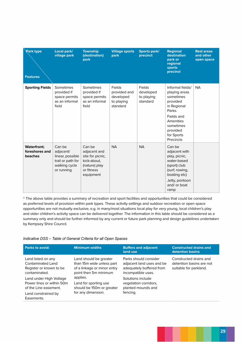
Sporting Fields Sometimes provided if space permits as an informal field
Sometimes provided if space permits as an informal field
Fields provided and developed to playing standard
Fields developed to playing standard
Informal fields/ playing areas sometimes provided in Regional Parks. Fields and Amenities sometimes provided for Sports Precincts
NA
Waterfront; foreshores and beaches
Can be adjacent/ linear, possible trail or path for walking cycle or running
Can be adjacent and site for picnic, kick-about, (nature) play or fitness equipment
NA NA Can be adjacent with play, picnic, water-based (sport) club (surf, rowing, boating etc) Jetty, pontoon and/ or boat ramp
^ The above table provides a summary of recreation and sport facilities and opportunities that could be considered as preferred levels of provision within park types. These activity settings and outdoor recreation or open space opportunities are not mutually exclusive, e.g. in many/most situations local play for very young, local children’s play and older children’s activity space can be delivered together. The information in this table should be considered as a summary only and should be further informed by any current or future park planning and design guidelines undertaken by Kempsey Shire Council.
Indicative DSS – Table of General Criteria for all Open Spaces
Parks to avoid: Minimum widths Buffers and adjacent land use
Constructed drains and detention basins
Land listed on any Contaminated Land Register or known to be contaminated. Land under High Voltage Power lines or within 50m of the Line easement. Land constrained by Easements.
Land should be greater than 15m wide unless part of a linkage or minor entry point then 5m minimum applies. Land for sporting use should be 150m or greater for any dimension.
Parks should consider adjacent land uses and be adequately buffered from incompatible uses. Solutions include vegetation corridors, planted mounds and fencing.
Constructed drains and detention basins are not suitable for parkland.
29
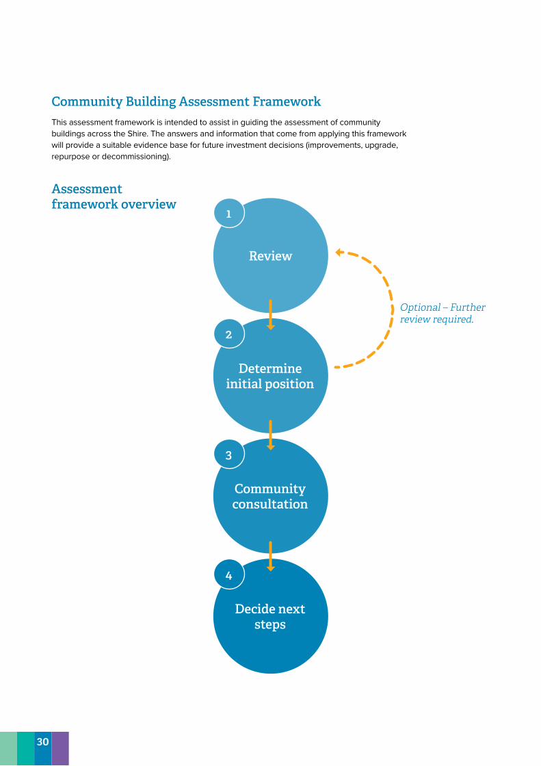
Community Building Assessment FrameworkThis assessment framework is intended to assist in guiding the assessment of community buildings across the Shire. The answers and information that come from applying this framework will provide a suitable evidence base for future investment decisions (improvements, upgrade, repurpose or decommissioning).
Review
1
Determine initial position
Community consultation
Decide next steps
2
3
4
Assessment framework overview
Review Optional – Further review required.
30
Assessment framework Stage 1 – Review community facility/facilities1. Does existing Council policy contain any direction for the community facility
Resources− Adopted State and local government strategies, policies and/or master plans.
2. Is there a demonstrated community demand or volume of requests for this facility to be replaced or refurbished? Resources− Section 355 committee reports and bookings register.− Maintenance requests from community.− Local master planning or structure plans. − Aligned Council policy− Population and demographic trends and forecasts.
3. Is the existing community facility in poor condition or no longer fit-for-purpose?
Considerations− Presence of vandalism or graffiti, facilities are unhygienic and difficult to maintain / clean.− Obvious signs of wear on the existing facility.− Features are broken or do not work.− Negative perceptions of safety.
Resources− Condition assessment.
4. Is the community facility being regularly used?Resources− Section 355 committee reports and bookings register − Active committee or organisation using the facility− Maintenance requests from community.
5. Is there a suitable or better alternative to the existing community facility within close proximity? Considerations− Surrounding community infrastructure which provides a similar purpose (and is not operating at capacity).
6. Does the community facility meet modern standards? Considerations− Disability Discrimination Act 1992 compliance.− Current building standards.− Meet minimal requirements to mitigate the impacts of natural hazards.
Stage Two – Determine Council’s initial positionDetermine whether facility should be improved, upgraded, repurposed or decommissioned in liaison with relevant Council departments and Councillors. This should also consider the financial implications of the course of action.
Stage Three – Consult the communityUndertake community consultation regarding proposed action. Council should develop an engagement approach which is fit-for-purpose and responds to the significance of the facility and/or Council’s initial position.
Stage Four – Decide next stepsIdentify next steps in progressing the improvement, upgrade, repurposing or decommissioning of the community facility/facilities. Next steps may require further detailed investigation and consultation (e.g. master planning a new community facility).
31
9.0 Monitoring and Evaluation9.1 Where to from here?This Community Infrastructure Strategy includes a range of recommendations to improve and ensure ongoing access to quality community infrastructure across the Macleay Valley over the next 20 years. There is likely to be further engagement and investigations required to implement some of these actions, including:
• Targeted consultation with existing service providers and facility operators• Targeted consultation with particular population groups (e.g. youth)• Scoping of potential delivery and/or funding partners
9.2 Implementation and MonitoringIt is recommended that Council review the key assumptions, models and actions of this plan in line with the release of new Census data to ensure they are still relevant and reflect the future needs of the local community.
Council will review the status of actions within this strategy every two years.
32
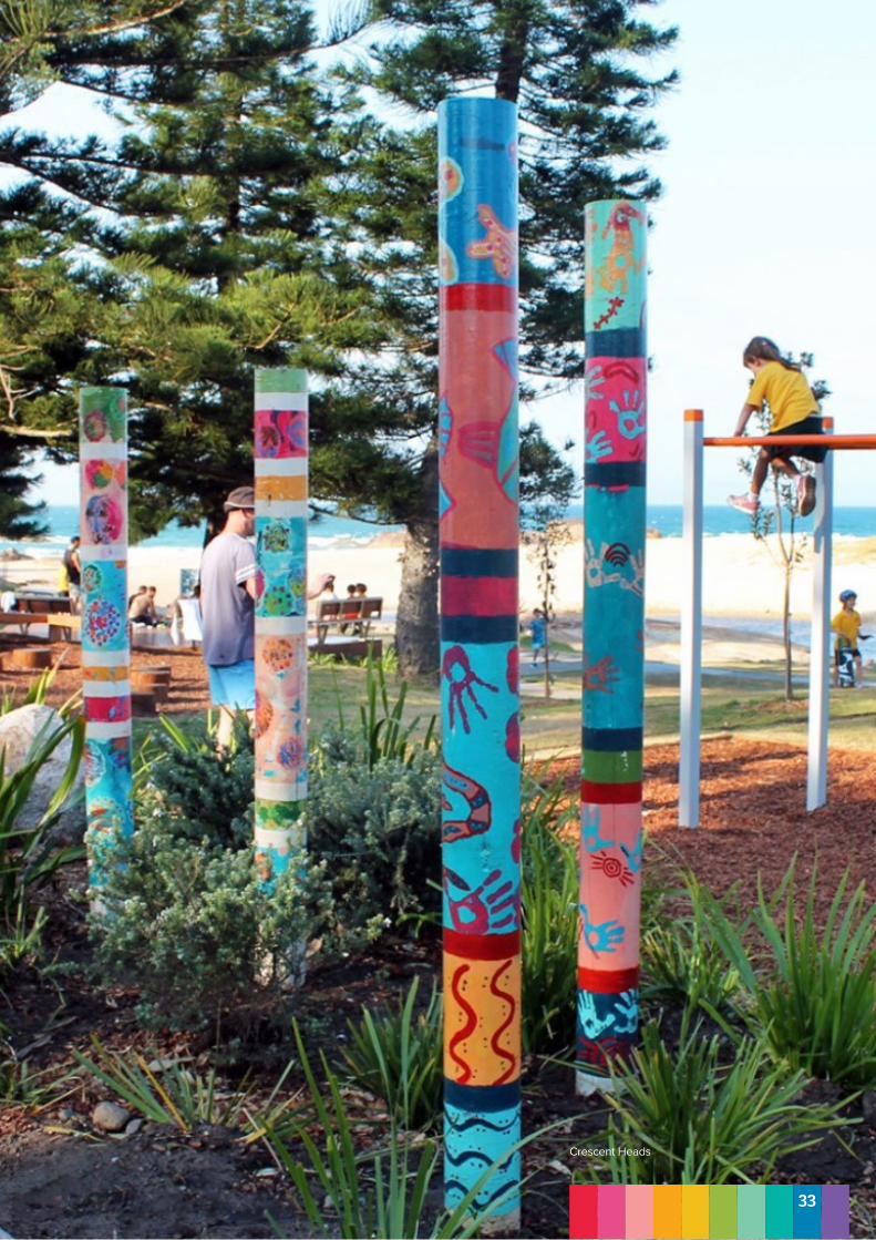
Crescent Heads
33