“Yes, but is there any air in space?”. MTPs Divisions of Domestic Airspace Northern vs. Southern...
20
Air Law - Airspace “Yes, but is there any air in space?”
-
Upload
gwendolyn-payne -
Category
Documents
-
view
214 -
download
0
Transcript of “Yes, but is there any air in space?”. MTPs Divisions of Domestic Airspace Northern vs. Southern...
Air Law - Airspace“Yes, but is there any air in space?”
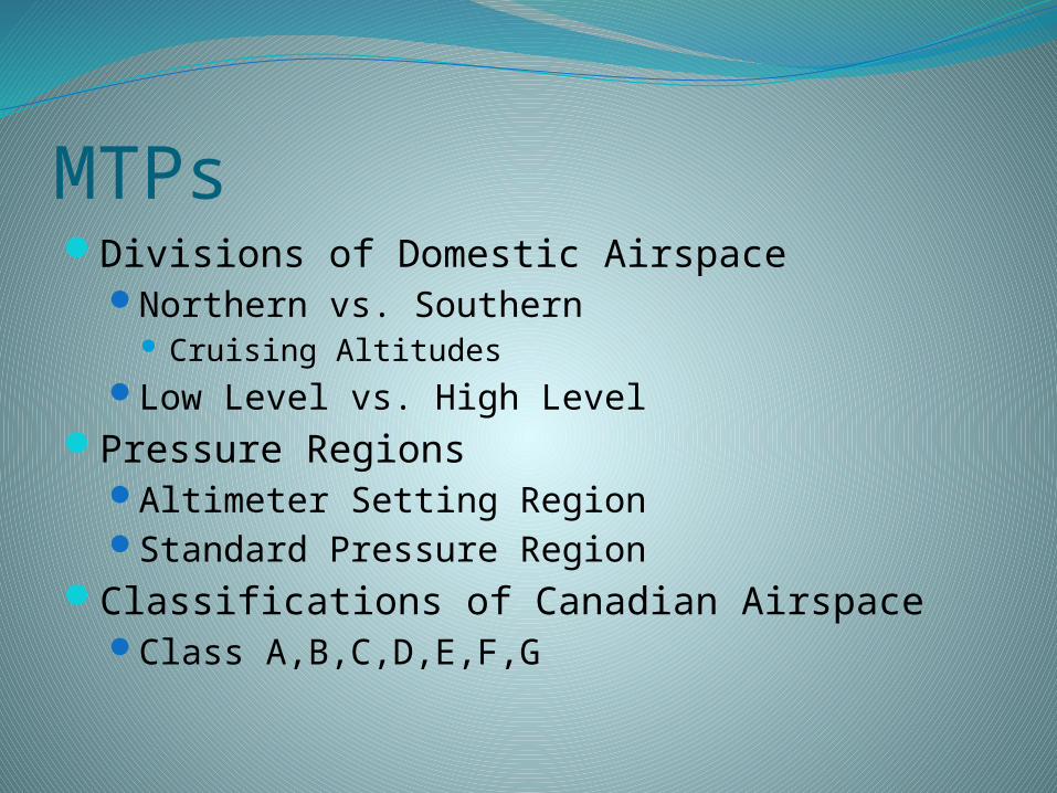
MTPsDivisions of Domestic Airspace
Northern vs. Southern Cruising Altitudes
Low Level vs. High LevelPressure Regions
Altimeter Setting RegionStandard Pressure Region
Classifications of Canadian Airspace Class A,B,C,D,E,F,G
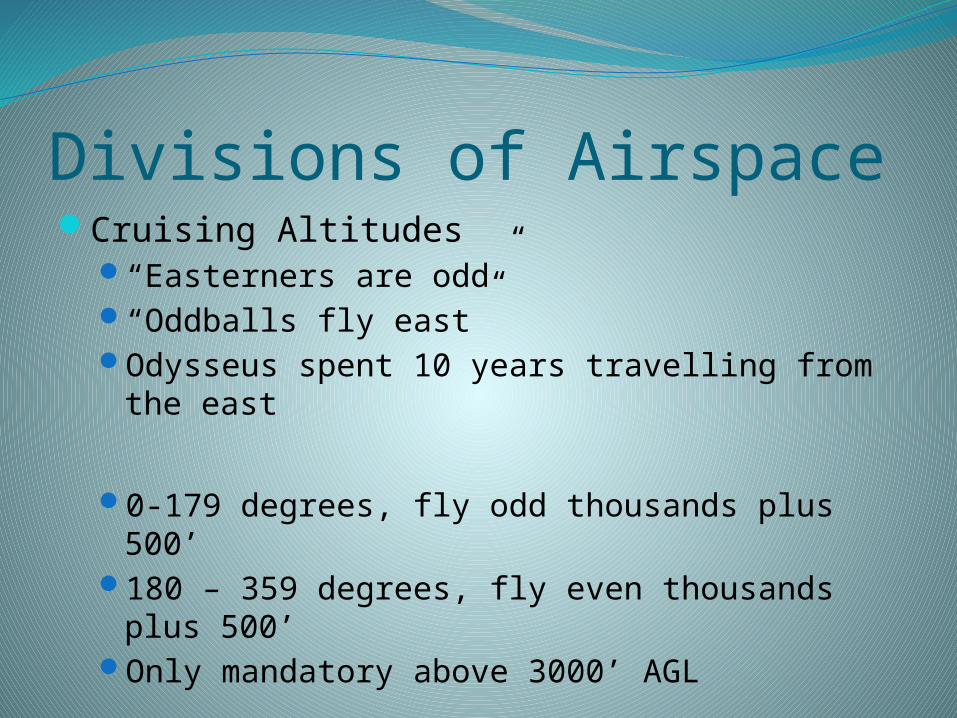
Divisions of AirspaceCruising Altitudes
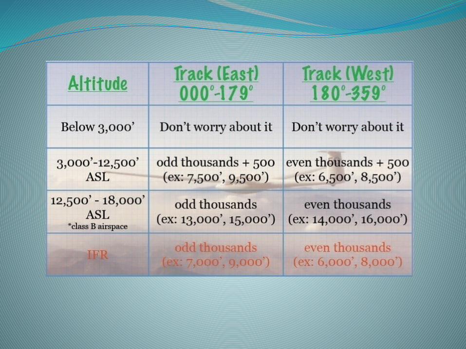
“Easterners are odd”“Oddballs fly east”Odysseus spent 10 years travelling from the
east
0-179 degrees, fly odd thousands plus 500’180 – 359 degrees, fly even thousands plus
500’Only mandatory above 3000’ AGL

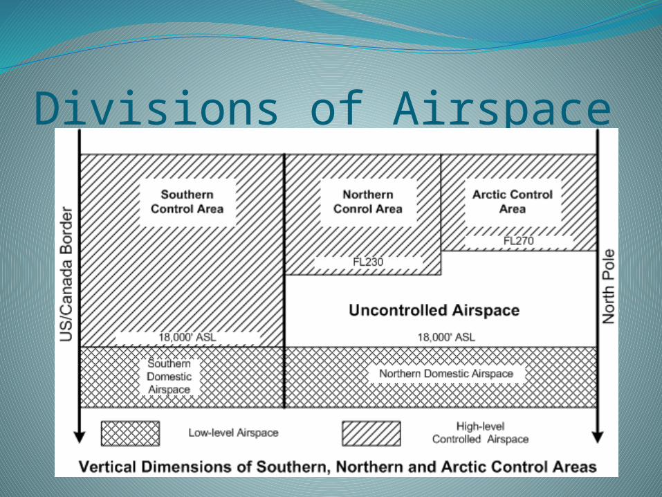
Divisions of AirspaceSouthern Domestic Airspace
Runways numbered by magnetic headingCruising altitude determined by magnetic
headingNorthern Domestic Airspace
Runways numbered by true headingCruising altitude determined by true heading

Divisions of AirspaceBased on Control:
High Level AirspaceAnything above 18 000’
ASL in SDAAbove 25 000’ ASL in
Northern Control Area, and 27 000’ in the Arctic Control Zone
Low Level AirspaceUncontrolled unless
otherwise stated.
Divisions of Airspace
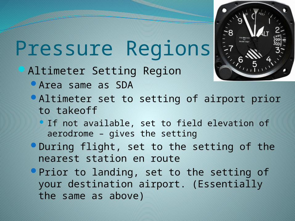
Pressure RegionsAltimeter Setting Region
Area same as SDAAltimeter set to setting of airport prior to
takeoff If not available, set to field elevation of aerodrome –
gives the settingDuring flight, set to the setting of the nearest
station en routePrior to landing, set to the setting of your
destination airport. (Essentially the same as above)

Pressure RegionsStandard Pressure Region
Anything in NDA, and/or above 18 000’ ASLDuring cruise in the region, set altimeter to
setting of 29.92’’ Hg Do this prior to attainment of cruising altitude or
just prior to attainment of FL 180, whichever comes first (FL 180 = 18 000’ ASL)
Prior to takeoff and prior to beginning landing descent, set altimeter to setting of departure/arrival aerodrome
When x-iting to Alt. Setting Region, set to nearest aerodrome prior to entry of ASR.

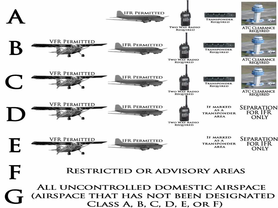
Classification of AirspaceLettered A-GIn “Controlled Airspace” (A-E), a controller
may issue a clearance or an instructionATC Clearance: Need not be followed until
acceptedATC Instruction: Must be complied with when
received
Classification of AirspaceClass G
Anything not designated as class A, B, C, D, E, or F
Both VFR and IFR may operate here – no special requirements placed on either
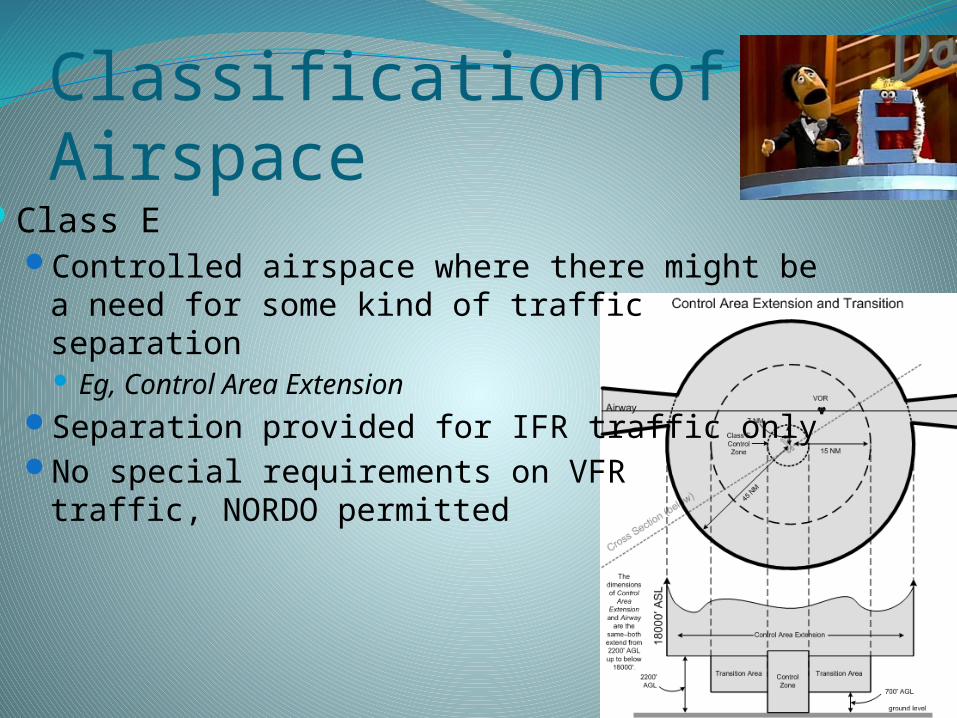
Classification of AirspaceClass E
Controlled airspace where there might be a need for some kind of traffic separation Eg, Control Area Extension
Separation provided for IFR traffic onlyNo special requirements on VFR
traffic, NORDO permitted
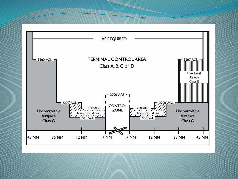
Classification of AirspaceClass D
Like Class E, only this is more specific to the areas directly connected to the aerodrome
Eg, Control Areas & Control ZonesDifferences:
Separation provided (where possible) for both IFR and VFR
VFR Restrictions: Must establish 2-way radio contact prior to entry,
maintain listening watch on frequency NORDO only w/ prior permission

Classification of AirspaceClass C
Similar role to Class D
Differences: Conflict resolution provided to all identified aircraft
VFR Restrictions: VFR must obtain clearance prior to entry, maintain
listening watch Must be equipped with a Class C transponder
(Alt/Code) NORDO only permitted with prior permission
Classification of AirspaceClass B
All airspace from FL 125 up to but not including 18 000’ ASL. “Low-level controlled airspace”
Differences: No NORDO permitted
VFR Restrictions: 2-Way Radio Equipment RNAV equipment to enable flight pursuant to flight
plan Xponder and automatic pressure altitude reporting
equipment
Classification of AirspaceClass A
All airspace FL 180 and up (to FL 600)VFR not permitted, except as authorized by TC
and ATC where it may be “in public interest”
NB: This is in… (standard/altimeter setting?) pressure region; what are altimeters set to?
Classification of AirspaceClass F
Airspace containing activities which may or may not present a hazard to aircraft
Encoded on charts by a three-letter/3-number identifier Letters indicate degree of restriction; the numbers, the
geographic areaEg, CYA 442
“CY” means Canadian “A” means advisory, “D” for Danger”, “R” for Restricted
Only “A” may be entered with out prior permission Generally, the frequency in such an area will be 126.7
MHz. 442 indicates the area, in this case Manitoba
These areas may be created by NOTAMs (ie, not appear on charts)