Yellowstone River Reach Narratives Reach...
6
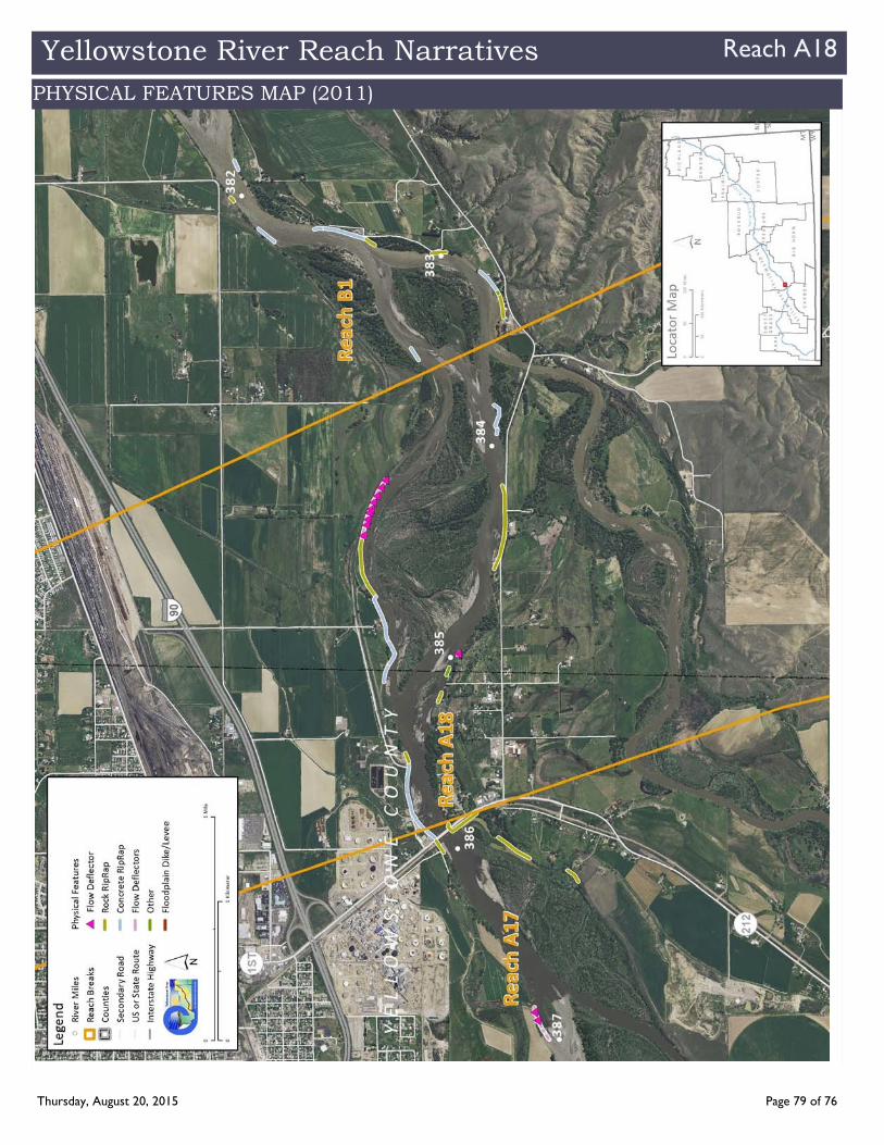
Yellowstone River Reach Narratives Reach A18 County Yellowstone Classification UA: Unconfined anabranching Narrative Summary Reach A18 is 2.5 miles long and extends from Laurel to the mouth of the Clarks Fork River. The reach is classified as Unconfined Anabranching (UA), which is characteristically one of the most dynamic reach types on the river. The reach has one large island and even though it is fairly intensively armored through Laurel, there has been over 1,100 feet of southward channel migration since 1950 at one location about ½ mile downstream of the bridge. Reach A18 is perhaps best known by the series of pipeline crossings below the Laurel Bridge. In 2011, floodwaters on the Yellowstone River peaked on July 2 at 70,600 cfs, which is an estimated 25 50 year flood event. On July 1, the day before the peak, a 12 inch diameter crude oil pipeline called the ExxonMobil Silvertip Pipeline, ruptured just downstream of the bridge in Reach A18. The pipeline was originally installed in a trench across the river that was 5 7 feet deep. The rupture spilled an estimated 50,000 gallons of oil into the Yellowstone River; the incident received national attention and millions of dollars were spent on cleanup. The Silvertip Pipeline and several others at this location have been replaced by HDD (Horizontal Directionally Drilled) lines. The industrial land uses at Laurel uses coupled with the dynamic nature of the Yellowstone River in Reach A18 has resulted in the armoring of almost 40 percent of the river in this reach. That armor consists of rock riprap, concrete riprap, and flow deflectors. Almost all of the armor is located on the north bank where it protects the City of Laurel sewage treatment facility, as well as a canal that leaves the river at RM 385.7. There is one small section of concrete armor on the north bank, and it appears that the upper 300 feet of this armor has been flanked and now is visible in the middle of the river. Recent concerns over the main intake structure for the city’s water supply sheds some light on the dynamics of the river, and potentially the influence of high density bank armor on channel stability. The 2011 flood evidently caused the river to downcut at the intake, perching the structure, such that there are current efforts in motion to relocate the intake several miles upstream. This downcutting may be related to the high density of armor between Laurel and Billings that effectively focuses flow into the main channel and can drive channel incision (downcutting). Reach conditions just downstream in Reach B1 support this hypothesis. There are over three miles of mapped dikes in Reach A18. Dikes, levees, and transportation encroachment features have isolated about one half of the historic 100 year floodplain in the reach. Almost 17 percent of the 5 year floodplain has become isolated from the river. Most of the isolated 100 year floodplain area is south of the river, between the Yellowstone and Clarks Fork Rivers. Land use in Reach A18 is primarily agricultural, although there are almost 380 acres of urban/exurban development in the reach as the river passes south of the City of Laurel. All of the irrigated land in Reach A18 is in flood irrigation. A total of 110 acres of developed ground are in the mapped Channel Migration Zone; and the over 90 percent of that is in urban/exurban land use. A total of 31 percent of the CMZ has become isolated by physical features. Riparian mapping indicates that since 1950, about 67 acres in the reach were cleared to support irrigation and other land uses. There are about 18 acres of mapped Russian olive in the floodplain. Since 1950, about 150 acres of land in Reach A18 was colonized by new riparian vegetation. There are over 140 acres of mapped emergent wetland in the reach, which consists primarily of emergent marshes and wet meadows. Almost 18 acres of Russian olive has been mapped in the floodplain. Reach A18 was sampled as part of the avian study. The average species richness in Reach A17 was 7.1, which indicates the average number of species observed during site visits to the reach in cottonwood habitats. The average species richness for all sites evaluated is 8. On average, of 0.9 Cowbirds were observed in cottonwood habitats during the field sampling visits. Reach A18 has lost all of its riparian forest considered at low risk of cowbird parasitism since 1950. At that time, there were 3.4 acres of forest per valley mile considered to be isolated enough from agricultural infrastructure and urban/exurban development to be considered at low risk. By 2011, that had been reduced to zero. A hydrologic evaluation of flow depletions indicates that flow alterations over the last century have been moderate in this reach. The mean annual flood is estimated to have dropped from 16,900 cfs to 15,500 cfs, a drop of about 8 percent. The biggest influence has been on low flows: severe low flows described as 7Q10 (the lowest average 7 day flow anticipated every ten years) for summer months has dropped from an estimated 2,780 cfs to 1,950 cfs with human development, a reduction of 30 percent. More typical summer low flows, described as the summer 95% flow duration, have dropped from 1,760 cfs under unregulated conditions to 1,680 cfs under regulated conditions at the Livingston gage, a reduction of 4.6 percent. CEA Related observations in Reach A18 include: •Flanking of concrete armor •Pipeline rupture in highly armored reach •Water intake perching in highly armored reach •Russian olive coloniza on •Emergent wetland development in abandoned side channels •Floodplain isola on at confluence between Clarks Fork and Yellowstone River from transporta on related infrastructure General Location To Clarks Fork Upstream River Mile 386 Downstream River Mile 383.5 Length 2.50 mi (4.02 km) Thursday, August 20, 2015 Page 75 of 76
Transcript of Yellowstone River Reach Narratives Reach...

Yellowstone River Reach Narratives Reach A18
County Yellowstone
Classification UA: Unconfined anabranching
Narrative Summary
Reach A18 is 2.5 miles long and extends from Laurel to the mouth of the Clarks Fork River. The reach is classified as Unconfined Anabranching (UA),
which is characteristically one of the most dynamic reach types on the river. The reach has one large island and even though it is fairly intensively
armored through Laurel, there has been over 1,100 feet of southward channel migration since 1950 at one location about ½ mile downstream of the
bridge.
Reach A18 is perhaps best known by the series of pipeline crossings below the Laurel Bridge. In 2011, floodwaters on the Yellowstone River peaked on
July 2 at 70,600 cfs, which is an estimated 25 50 year flood event. On July 1, the day before the peak, a 12 inch diameter crude oil pipeline called the
ExxonMobil Silvertip Pipeline, ruptured just downstream of the bridge in Reach A18. The pipeline was originally installed in a trench across the river
that was 5 7 feet deep. The rupture spilled an estimated 50,000 gallons of oil into the Yellowstone River; the incident received national attention and
millions of dollars were spent on cleanup. The Silvertip Pipeline and several others at this location have been replaced by HDD (Horizontal Directionally
Drilled) lines.
The industrial land uses at Laurel uses coupled with the dynamic nature of the Yellowstone River in Reach A18 has resulted in the armoring of almost
40 percent of the river in this reach. That armor consists of rock riprap, concrete riprap, and flow deflectors. Almost all of the armor is located on the
north bank where it protects the City of Laurel sewage treatment facility, as well as a canal that leaves the river at RM 385.7. There is one small section
of concrete armor on the north bank, and it appears that the upper 300 feet of this armor has been flanked and now is visible in the middle of the
river. Recent concerns over the main intake structure for the city’s water supply sheds some light on the dynamics of the river, and potentially the
influence of high density bank armor on channel stability. The 2011 flood evidently caused the river to downcut at the intake, perching the structure,
such that there are current efforts in motion to relocate the intake several miles upstream. This downcutting may be related to the high density of
armor between Laurel and Billings that effectively focuses flow into the main channel and can drive channel incision (downcutting). Reach conditions
just downstream in Reach B1 support this hypothesis.
There are over three miles of mapped dikes in Reach A18. Dikes, levees, and transportation encroachment features have isolated about one half of the
historic 100 year floodplain in the reach. Almost 17 percent of the 5 year floodplain has become isolated from the river. Most of the isolated 100 year
floodplain area is south of the river, between the Yellowstone and Clarks Fork Rivers.
Land use in Reach A18 is primarily agricultural, although there are almost 380 acres of urban/exurban development in the reach as the river passes
south of the City of Laurel. All of the irrigated land in Reach A18 is in flood irrigation. A total of 110 acres of developed ground are in the mapped
Channel Migration Zone; and the over 90 percent of that is in urban/exurban land use. A total of 31 percent of the CMZ has become isolated by
physical features.
Riparian mapping indicates that since 1950, about 67 acres in the reach were cleared to support irrigation and other land uses. There are about 18
acres of mapped Russian olive in the floodplain.
Since 1950, about 150 acres of land in Reach A18 was colonized by new riparian vegetation. There are over 140 acres of mapped emergent wetland in
the reach, which consists primarily of emergent marshes and wet meadows.
Almost 18 acres of Russian olive has been mapped in the floodplain.
Reach A18 was sampled as part of the avian study. The average species richness in Reach A17 was 7.1, which indicates the average number of species
observed during site visits to the reach in cottonwood habitats. The average species richness for all sites evaluated is 8. On average, of 0.9 Cowbirds
were observed in cottonwood habitats during the field sampling visits. Reach A18 has lost all of its riparian forest considered at low risk of cowbird
parasitism since 1950. At that time, there were 3.4 acres of forest per valley mile considered to be isolated enough from agricultural infrastructure and
urban/exurban development to be considered at low risk. By 2011, that had been reduced to zero.
A hydrologic evaluation of flow depletions indicates that flow alterations over the last century have been moderate in this reach. The mean annual
flood is estimated to have dropped from 16,900 cfs to 15,500 cfs, a drop of about 8 percent. The biggest influence has been on low flows: severe low
flows described as 7Q10 (the lowest average 7 day flow anticipated every ten years) for summer months has dropped from an estimated 2,780 cfs to
1,950 cfs with human development, a reduction of 30 percent. More typical summer low flows, described as the summer 95% flow duration, have
dropped from 1,760 cfs under unregulated conditions to 1,680 cfs under regulated conditions at the Livingston gage, a reduction of 4.6 percent.
CEA Related observations in Reach A18 include:
•Flanking of concrete armor
•Pipeline rupture in highly armored reach
•Water intake perching in highly armored reach
•Russian olive coloniza on
•Emergent wetland development in abandoned side channels
•Floodplain isola on at confluence between Clarks Fork and Yellowstone River from transporta on related infrastructure
General Location To Clarks Fork
Upstream River Mile 386
Downstream River Mile 383.5
Length 2.50 mi (4.02 km)
Thursday, August 20, 2015 Page 75 of 76

Yellowstone River Reach Narratives Reach A18•Extensive CMZ encroachment in urbanized reach
Recommended Practices (may include Yellowstone River Recommended Practices YRRPs) for Reach A18 include:
•Irriga on diversion structure management at headgate on at a canal at RM 385.7
•Flanked concrete armor removal RM 384
•Russian olive removal (18 acres)
•Floodplain restora on between lower Clarks Fork River and Yellowstone River
•Pipeline Management for several crossings at Laurel.
Thursday, August 20, 2015 Page 76 of 76

Yellowstone River Reach Narratives Reach A18
Thursday, August 20, 2015 Page 77 of 76
Yellowstone River Reach Narratives Reach A18
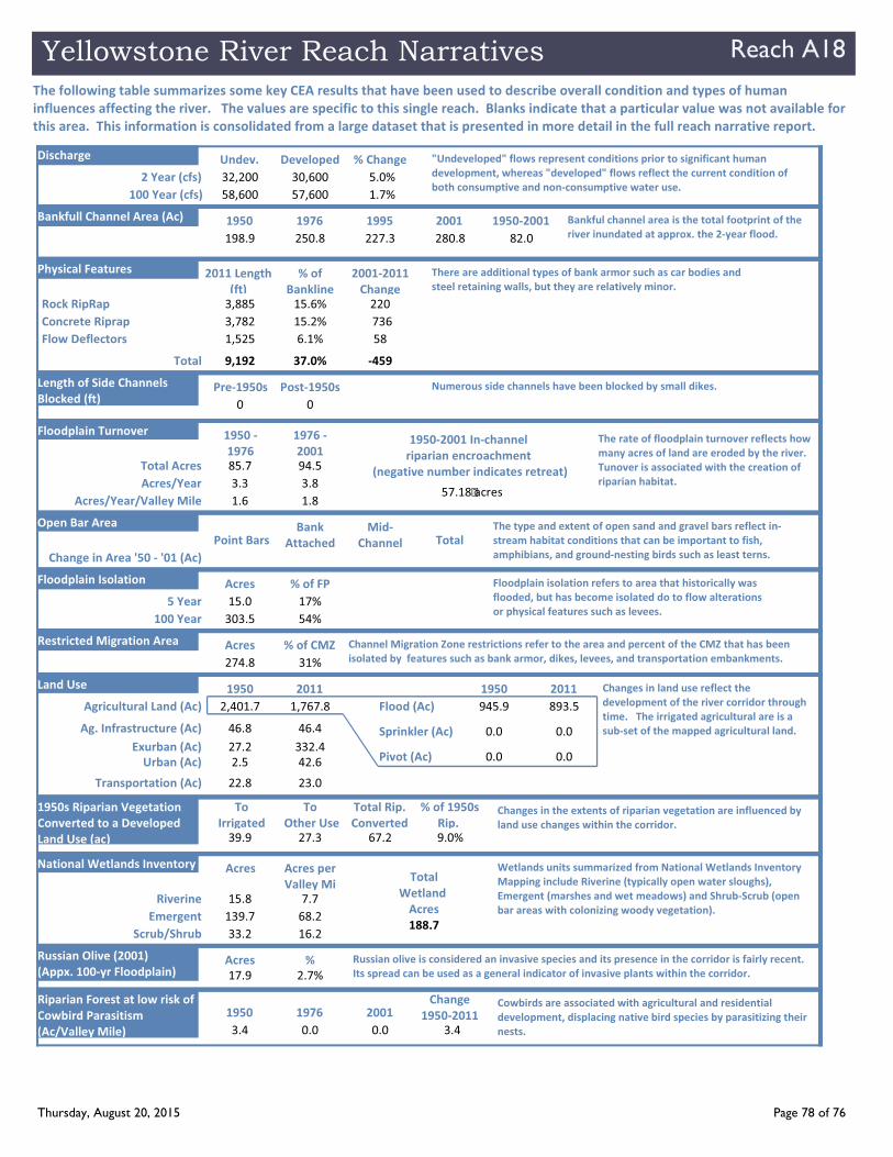
The following table summarizes some key CEA results that have been used to describe overall condition and types of human
influences affecting the river. The values are specific to this single reach. Blanks indicate that a particular value was not available for
this area. This information is consolidated from a large dataset that is presented in more detail in the full reach narrative report.
Agricultural Land (Ac) 2,401.7
Ag. Infrastructure (Ac) 46.8
Exurban (Ac) 27.2
Urban (Ac) 2.5
Transportation (Ac) 22.8
1,767.8
46.4
332.4
42.6
23.0
Flood (Ac) 945.9
Sprinkler (Ac) 0.0
Pivot (Ac) 0.0
893.5
0.0
0.0
Rock RipRap 3,885 15.6%
Concrete Riprap 3,782 15.2%
Flow Deflectors 1,525 6.1%
220
736
58
Length of Side Channels
Blocked (ft) 0 0
2 Year (cfs) 32,200 30,600
100 Year (cfs) 58,600 57,600
5.0%
1.7%
100 Year 303.5 54%
5 Year 15.0 17%
1950s Riparian Vegetation
Converted to a Developed
Land Use (ac) 39.9 27.3 67.2 9.0%
1950 2011 1950 2011
2011 Length
(ft)
% of
Bankline
Undev. Developed % Change
Acres % of FP
To
Irrigated
To
Other Use
Total Rip.
Converted
% of 1950s
Rip.
2001 2011
Change
Pre 1950s Post 1950s
Russian Olive (2001)
(Appx. 100 yr Floodplain) 17.9 2.7%
Acres %
Bankfull Channel Area (Ac)
198.9 250.8 227.3 280.8
1950 1976 1995 2001
Change in Area '50 '01 (Ac)
Point BarsBank
Attached
Mid
Channel Total
Total Acres 85.7 94.5
Acres/Year 3.3 3.8
Acres/Year/Valley Mile 1.6 1.8
1950
1976
1976
2001
Floodplain Turnover
82.0
1950 2001
"Undeveloped" flows represent conditions prior to significant human
development, whereas "developed" flows reflect the current condition of
both consumptive and non consumptive water use.
There are additional types of bank armor such as car bodies and
steel retaining walls, but they are relatively minor.
Floodplain isolation refers to area that historically was
flooded, but has become isolated do to flow alterations
or physical features such as levees.
Numerous side channels have been blocked by small dikes.
The rate of floodplain turnover reflects how
many acres of land are eroded by the river.
Tunover is associated with the creation of
riparian habitat.
The type and extent of open sand and gravel bars reflect in
stream habitat conditions that can be important to fish,
amphibians, and ground nesting birds such as least terns.
Bankful channel area is the total footprint of the
river inundated at approx. the 2 year flood.
Changes in land use reflect the
development of the river corridor through
time. The irrigated agricultural are is a
sub set of the mapped agricultural land.
Changes in the extents of riparian vegetation are influenced by
land use changes within the corridor.
Russian olive is considered an invasive species and its presence in the corridor is fairly recent.
Its spread can be used as a general indicator of invasive plants within the corridor.
Riverine 15.8 7.7
Emergent 139.7 68.2
Scrub/Shrub 33.2 16.2
Acres Acres per
Valley Mi
National Wetlands Inventory Wetlands units summarized from National Wetlands Inventory
Mapping include Riverine (typically open water sloughs),
Emergent (marshes and wet meadows) and Shrub Scrub (open
bar areas with colonizing woody vegetation).
Riparian Forest at low risk of
Cowbird Parasitism
(Ac/Valley Mile) 3.4 0.0 0.0 3.4
1950 1976 2001Change
1950 2011Cowbirds are associated with agricultural and residential
development, displacing native bird species by parasitizing their
nests.
1950 2001 In channel
riparian encroachment
(negative number indicates retreat)
57.18 acres
Total 9,192 37.0% 459
Restricted Migration Area
274.8 31%
Acres % of CMZ Channel Migration Zone restrictions refer to the area and percent of the CMZ that has been
isolated by features such as bank armor, dikes, levees, and transportation embankments.
188.7
Total
Wetland
Acres
Discharge
Physical Features
Open Bar Area
Floodplain Isolation
Land Use
Thursday, August 20, 2015 Page 78 of 76
Yellowstone River Reach Narratives Reach A18
PHYSICAL FEATURES MAP (2011)
Thursday, August 20, 2015 Page 79 of 76

Yellowstone River Reach Narratives Reach A18
CHANNEL MIGRATION ZONE MAP
Thursday, August 20, 2015 Page 80 of 76