Year 8 unit overview — Australian Curriculum: … · Web viewInsert fact sheet title Insert fact...
21
Year 8 unit overview — Australian Curriculum: Geography Source: Australian Curriculum, Assessment and Reporting Authority (ACARA), Australian Curriculum v5.0: Geography for Foundation–10, www.australiancurriculum.edu.au/Geography/Curriculum/F-10. Unit no. Unit title Duration of unit 2 Changing nations 25 hours Unit outline The Year 8 curriculum develops students’ understanding of spatial change in the distribution of populations at a variety of scales. Changing nations investigates the changing human geography of countries, as revealed by shifts in population distribution. The spatial distribution of population is a sensitive indicator of economic and social change, and has significant environmental, economic and social effects, both negative and positive. The unit explores the process of urbanisation and draws on a study of a country of the Asia region to show how urbanisation changes the economies and societies of low and middle-income countries. countries. It investigates the reasons for the high level of urban concentration in Australia, one of the distinctive features of Australia’s human geography, and compares Australia with the United States of America. The redistribution of population resulting from internal migration is examined through case studies of Australia and China, and is contrasted with the way international migration reinforces urban concentration in Australia. The unit then examines issues related to the management and future of Australia’s urban areas. Students’ geographical knowledge and mental map of the world continue to be extended through the investigation of selective studies of world regions and specific countries. Where studies of place are not specified, teachers can select an area of Australia, or countries in the Asia region, or areas of the world, which are contextually appropriate. Students undertake studies at the full range of scales, from local to global, and in a range of locations. Fieldwork opportunities exist in this unit. Geographical contexts includes: a local urban area that is culturally diverse, a local planning community site or a local planned community project that has been planned for environmentally sustainability and/or liveability. Possible data collection techniques include: observing, field DRAFT Queensland Studies Authority July 2013 | 1
Transcript of Year 8 unit overview — Australian Curriculum: … · Web viewInsert fact sheet title Insert fact...

Year 8 unit overview — Australian Curriculum: GeographySource: Australian Curriculum, Assessment and Reporting Authority (ACARA), Australian Curriculum v5.0: Geography for Foundation–10, www.australiancurriculum.edu.au/Geography/Curriculum/F-10.
Unit no. Unit title Duration of unit
2 Changing nations 25 hours
Unit outline
The Year 8 curriculum develops students’ understanding of spatial change in the distribution of populations at a variety of scales.Changing nations investigates the changing human geography of countries, as revealed by shifts in population distribution. The spatial distribution of population is a sensitive indicator of economic and social change, and has significant environmental, economic and social effects, both negative and positive. The unit explores the process of urbanisation and draws on a study of a country of the Asia region to show how urbanisation changes the economies and societies of low and middle-income countries. countries. It investigates the reasons for the high level of urban concentration in Australia, one of the distinctive features of Australia’s human geography, and compares Australia with the United States of America. The redistribution of population resulting from internal migration is examined through case studies of Australia and China, and is contrasted with the way international migration reinforces urban concentration in Australia. The unit then examines issues related to the management and future of Australia’s urban areas.Students’ geographical knowledge and mental map of the world continue to be extended through the investigation of selective studies of world regions and specific countries. Where studies of place are not specified, teachers can select an area of Australia, or countries in the Asia region, or areas of the world, which are contextually appropriate. Students undertake studies at the full range of scales, from local to global, and in a range of locations.Fieldwork opportunities exist in this unit. Geographical contexts includes: a local urban area that is culturally diverse, a local planning community site or a local planned community project that has been planned for environmentally sustainability and/or liveability. Possible data collection techniques include: observing, field sketching, taking photographs, surveys and questionnaires, environmental quality and perception sheets and GPS positioning.There is a focus in this unit on the use of geographical inquiry and skills. The students will: represent data in a range of appropriate forms such as compound column graphs and population pyramids, using spatial technology as appropriate represent the spatial distribution of geographical phenomena by constructing maps at different scales using spatial technology as appropriate analyse geographical data and other information to identify spatial distributions, patterns and trend and infer relationships draw conclusions based on the analysis of the data and information collected present findings, arguments and ideas in a range of communication forms
using geographical terminology and digital technologies where appropriateThe inquiry questions for the unit are: How do human processes, such as urbanisation and migration, affect the characteristics of places? How do the interconnections between places and people (e.g. through production, consumption, transport and technology) affect the lives of people? What are the consequences of changes to places from urbanisation and migration and how can these changes be managed?
DRAFT Queensland Studies Authority July 2013 | 1

Identify curriculum
Content descriptions to be taught General capabilities and cross-curriculum prioritiesGeographical Knowledge and Understanding Geographical Inquiry and Skills
The causes and consequences of urbanisation, drawing on a study from Indonesia, or another country of the Asia region (ACHGK054)
The differences in urban concentration and urban settlement patterns between Australia and the United States of America, and their causes and consequences (ACHGK055)
The reasons for and effects of internal migration in Australia (ACHGK056)
The reasons for and effects of internal migration in China (ACHGK057)
The reasons for and effects of international migration in Australia (ACHGK058)
The management and planning of Australia’s urban future (ACHGK059)
Collecting, recording, evaluating and representing Evaluate sources for their reliability and
usefulness and represent data in a range of appropriate forms, for example, climate graphs, compound column graphs, population pyramids, tables, field sketches and annotated diagrams, with and without the use of digital and spatial technologies (ACHGS057)
Represent the spatial distribution of different types of geographical phenomena by constructing appropriate maps at different scales that conform to cartographic conventions, using spatial technologies as appropriate (ACHGS058)
Interpreting, analysing and concluding Analyse geographical data and other
information using qualitative and quantitative methods, and digital and spatial technologies as appropriate, to identify and propose explanations for spatial distributions, patterns and trends and infer relationships (ACHGS059)
Apply geographical concepts to draw conclusions based on the analysis of the data and information collected (ACHGS060)
Communicating Present findings, arguments and ideas in a
range of communication forms selected to suit a particular audience and purpose, using geographical terminology and digital technologies as appropriate (ACHGS061)
The application of the general capabilities and cross-curriculum priorities in this include may include:
LiteracyUse geographical terminology to explain the
causes and consequences of urbanisation
Numeracy Interpret population pyramids to identify
demographic trends
ICT capabilityUse spatial technologies to explore the
population distributions of urban centres in Australia
Critical and creative thinkingEvaluate data and information gathered from
sources for reliability and bias
Personal and social capabilityCollaborate to develop a management plan for
Australia’s urban centres.
Ethical understandingReflect on personal values and attitudes towards
international migration
Intercultural understanding Investigate why international migrants settle in
Australia
2 | DRAFT Year 8 unit overview Australian Curriculum: Geography

Identify curriculum
Aboriginal and Torres Strait Islander histories and cultures
Use protocols for consultation with Aboriginal and Torres Strait Islander communities
Asia and Australia’s engagement with Asia Identify the types and patterns of migration from
the Asian region
SustainabilityDiscuss the environmental sustainability of
projected population growth for Australia
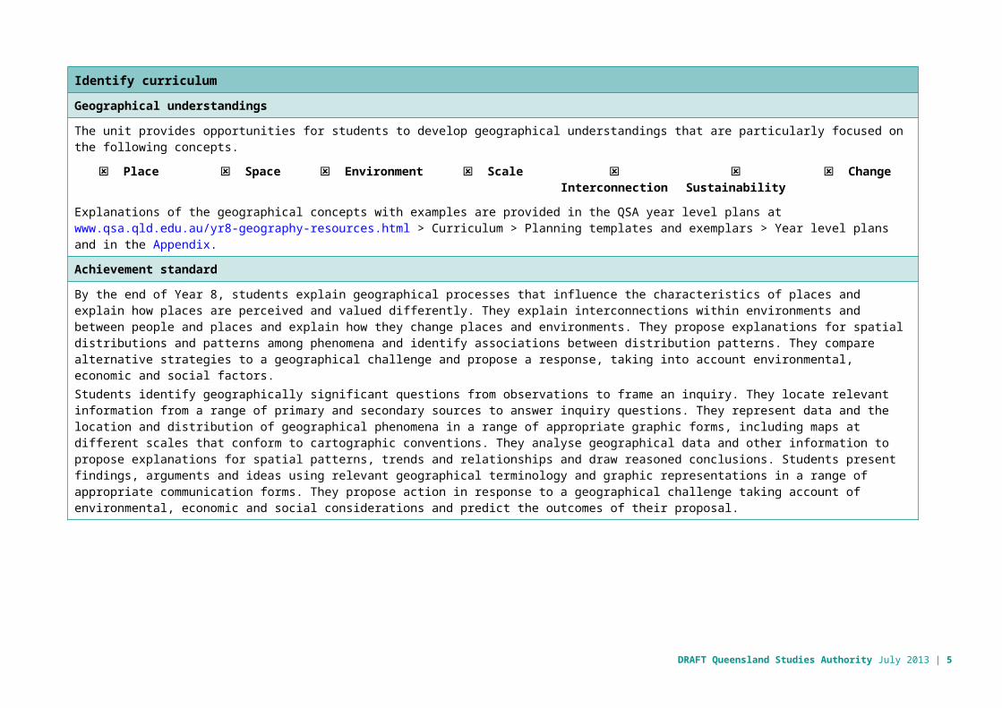
Geographical understandings
The unit provides opportunities for students to develop geographical understandings that are particularly focused on the following concepts.
☒ Place ☒ Space ☒ Environment ☒ Scale ☒ Interconnection ☒ Sustainability ☒ Change
Explanations of the geographical concepts with examples are provided in the QSA year level plans at www.qsa.qld.edu.au/yr8-geography-resources.html > Curriculum > Planning templates and exemplars > Year level plans and in the Appendix.
Achievement standard
By the end of Year 8, students explain geographical processes that influence the characteristics of places and explain how places are perceived and valued differently. They explain interconnections within environments and between people and places and explain how they change places and environments. They propose explanations for spatial distributions and patterns among phenomena and identify associations between distribution patterns. They compare alternative strategies to a geographical challenge and propose a response, taking into account environmental, economic and social factors.Students identify geographically significant questions from observations to frame an inquiry. They locate relevant information from a range of primary and secondary sources to answer inquiry questions. They represent data and the location and distribution of geographical phenomena in a range of appropriate graphic forms, including maps at different scales that conform to cartographic conventions. They analyse geographical data and other information to propose explanations for spatial patterns, trends and relationships and draw reasoned conclusions. Students present findings, arguments and ideas using relevant geographical terminology and graphic representations in a range of appropriate communication forms. They propose action in response to a geographical challenge taking account of environmental, economic and social considerations and predict the outcomes of their proposal.
DRAFT Queensland Studies Authority July 2013 | 3

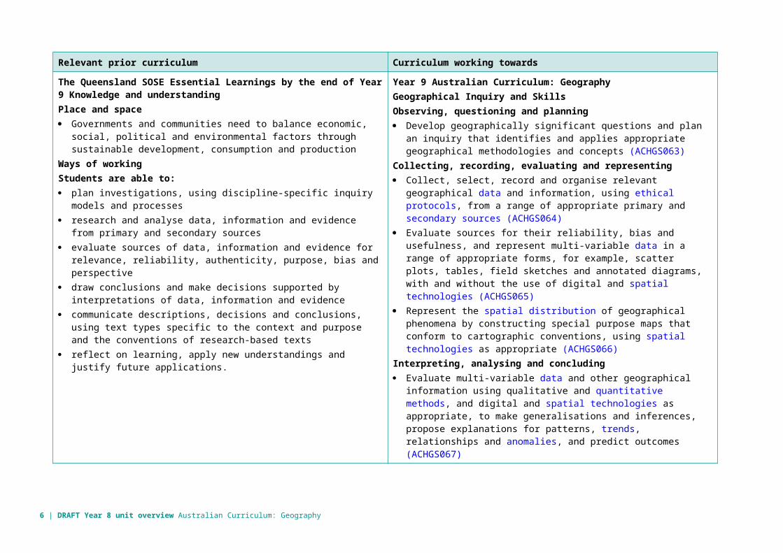
Relevant prior curriculum Curriculum working towards
The Queensland SOSE Essential Learnings by the end of Year 9 Knowledge and understandingPlace and space Governments and communities need to balance economic, social, political
and environmental factors through sustainable development, consumption and production
Ways of workingStudents are able to: plan investigations, using discipline-specific inquiry models and processes research and analyse data, information and evidence from primary and
secondary sources evaluate sources of data, information and evidence for relevance, reliability,
authenticity, purpose, bias and perspective draw conclusions and make decisions supported by interpretations of data,
information and evidence communicate descriptions, decisions and conclusions, using text types
specific to the context and purpose and the conventions of research-based texts
reflect on learning, apply new understandings and justify future applications.
Year 9 Australian Curriculum: GeographyGeographical Inquiry and SkillsObserving, questioning and planning Develop geographically significant questions and plan an inquiry that
identifies and applies appropriate geographical methodologies and concepts (ACHGS063)
Collecting, recording, evaluating and representing Collect, select, record and organise relevant geographical data and
information, using ethical protocols, from a range of appropriate primary and secondary sources (ACHGS064)
Evaluate sources for their reliability, bias and usefulness, and represent multi-variable data in a range of appropriate forms, for example, scatter plots, tables, field sketches and annotated diagrams, with and without the use of digital and spatial technologies (ACHGS065)
Represent the spatial distribution of geographical phenomena by constructing special purpose maps that conform to cartographic conventions, using spatial technologies as appropriate (ACHGS066)
Interpreting, analysing and concluding Evaluate multi-variable data and other geographical information using
qualitative and quantitative methods, and digital and spatial technologies as appropriate, to make generalisations and inferences, propose explanations for patterns, trends, relationships and anomalies, and predict outcomes (ACHGS067)
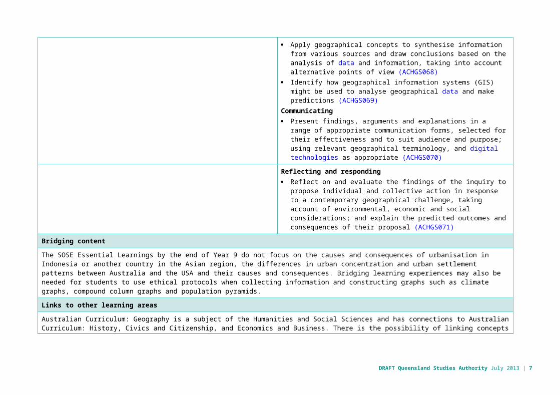
Apply geographical concepts to synthesise information from various sources and draw conclusions based on the analysis of data and information, taking into account alternative points of view (ACHGS068)
Identify how geographical information systems (GIS) might be used to analyse geographical data and make predictions (ACHGS069)
Communicating Present findings, arguments and explanations in a range of appropriate
communication forms, selected for their effectiveness and to suit audience and purpose; using relevant geographical terminology, and digital technologies as appropriate (ACHGS070)
Reflecting and responding
4 | DRAFT Year 8 unit overview Australian Curriculum: Geography
Reflect on and evaluate the findings of the inquiry to propose individual and collective action in response to a contemporary geographical challenge, taking account of environmental, economic and social considerations; and explain the predicted outcomes and consequences of their proposal (ACHGS071)
Bridging content
The SOSE Essential Learnings by the end of Year 9 do not focus on the causes and consequences of urbanisation in Indonesia or another country in the Asian region, the differences in urban concentration and urban settlement patterns between Australia and the USA and their causes and consequences. Bridging learning experiences may also be needed for students to use ethical protocols when collecting information and constructing graphs such as climate graphs, compound column graphs and population pyramids.
Links to other learning areas
Australian Curriculum: Geography is a subject of the Humanities and Social Sciences and has connections to Australian Curriculum: History, Civics and Citizenship, and Economics and Business. There is the possibility of linking concepts and content in the unit that may be taught in other curriculum areas when implementing the Australian Curriculum: Geography.
DRAFT Queensland Studies Authority July 2013 | 5
Assessment Make judgments
Describe the assessment Teachers gather evidence to make judgments about the following characteristics of student work:Understanding Explain geographical processes that influence the
characteristics of places Explain interconnections within environments and between
people and places Propose explanations for spatial distributions and patternsSkills Represent data and the location and distribution of
geographical phenomena in a range of different graphic forms
Analyse geographical data to propose explanations for spatial patterns
Draw reasoned conclusionsThe valued features of the standard elaborations targeted in this assessment are: Geographical knowledge and understanding Questioning and researching Interpreting and analysing CommunicatingFor further advice and guidelines on constructing task-specific standards, refer to the standards elaborations: www.qsa.qld.edu.au/26025.html > select the Year level > choose the Resources tab > Standards elaborations.
Students are given opportunities to demonstrate their knowledge, skills and understanding across a range of assessments. This assessment is collected in student folios and allows for ongoing feedback to students on their learning.The teaching and learning experiences throughout the term provide opportunities for students to develop the understanding and skills required to complete these assessments. As students engage with these learning experiences, the teacher can provide feedback on specific skills.Supervised assessment: Practical exerciseThis practical exercise requires students to manipulate and represent geographical data from primary and secondary sources.This technique is used to assess student responses that are produced independently, under supervision and in a set time frame. A supervised assessment ensures there is no question about student authorship.The purpose of this assessment is to make judgments about students’ abilities to, represent, analyse, draw conclusions and present findings about how urbanisation changes places.Students will: construct graphs representing demographic data create a choropleth map illustrating spatial distribution analyse data and other information using qualitative and quantitative methods to identify
and explain patterns, trends infer relationships to draw conclusions present arguments and ideas using geographical terminology appropriately.Suggested conditions: 45–60 mins up to 350 wordsResource required Global Education — Poverty and urbanisation
www.globaleducation.edu.au/teaching-activity/poverty-and-urbanisation.html
Refer to Australian Curriculum: Geography — Assessment categories, techniques and conditions: www.qsa.qld.edu.au/downloads/p_10/ac_geography_assess_advice.pdf
6 | DRAFT Year 8 unit overview Australian Curriculum: Geography
DRAFT Queensland Studies Authority July 2013 | 7
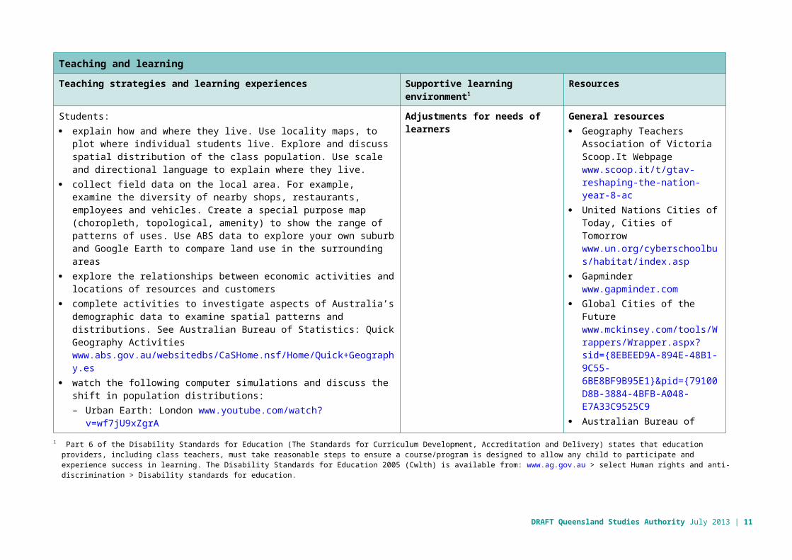
Teaching and learning
Teaching strategies and learning experiences Supportive learning environment1 Resources
Students: explain how and where they live. Use locality maps, to plot where individual
students live. Explore and discuss spatial distribution of the class population. Use scale and directional language to explain where they live.
collect field data on the local area. For example, examine the diversity of nearby shops, restaurants, employees and vehicles. Create a special purpose map (choropleth, topological, amenity) to show the range of patterns of uses. Use ABS data to explore your own suburb and Google Earth to compare land use in the surrounding areas
explore the relationships between economic activities and locations of resources and customers
complete activities to investigate aspects of Australia’s demographic data to examine spatial patterns and distributions. See Australian Bureau of Statistics: Quick Geography Activities www.abs.gov.au/websitedbs/CaSHome.nsf/Home/Quick+Geography.es
watch the following computer simulations and discuss the shift in population distributions:– Urban Earth: London www.youtube.com/watch?v=wf7jU9xZgrA– World Population www.youtube.com/watch?v=4BbkQiQyaYc
define urbanisation and global population trends. Examine the satellite images of the Earth by night and explain the spatial patterns reveal of world urbanisation (Choropleth map activity mapping world urbanisation)http://geology.com/articles/satellite-photo-earth-at-night.shtml
discuss the social, economic and environmental causes and consequences of urbanisation:– explore push and pull factors influencing where people live and work– investigate the push and pull factors of migration by undertaking a case
study of Indonesia. Explore the causes and consequences of urbanisation, drawing on a study from Indonesia, or another country of the Asian region
Adjustments for needs of learners General resources Geography Teachers
Association of VictoriaScoop.It Webpage www.scoop.it/t/gtav-reshaping-the-nation-year-8-ac
United Nations Cities of Today, Cities of Tomorrow www.un.org/cyberschoolbus/habitat/index.asp
Gapminderwww.gapminder.com
Global Cities of the Future www.mckinsey.com/tools/Wrappers/Wrapper.aspx?sid={8EBEED9A-894E-48B1-9C55-6BE8BF9B95E1}&pid={79100D8B-3884-4BFB-A048-E7A33C9525C9
Australian Bureau of Statistics (ABS) http://www.abs.gov.au
Mapping the world’s friendships www.facebookstories.com/stories/1574/interactive-mapping-the-world-s-friendships#color=continent&story=1&country=US (Facebook interactive: Mapping the World's Friendships )
1 Part 6 of the Disability Standards for Education (The Standards for Curriculum Development, Accreditation and Delivery) states that education providers, including class teachers, must take reasonable steps to ensure a course/program is designed to allow any child to participate and experience success in learning. The Disability Standards for Education 2005 (Cwlth) is available from: www.ag.gov.au > select Human rights and anti-discrimination > Disability standards for education.
8 | DRAFT Year 8 unit overview Australian Curriculum: Geography

Teaching and learning
Teaching strategies and learning experiences Supportive learning environment Resources
compare the differences in urban concentration and urban settlement patterns between Australia and United States:– investigate population distributions by looking at maps of Australia and the
US (Boston, Washington, New York)– identify reasons of settlement patterns and population distribution
(historical reasons, transport and infrastructure etc.) investigate the reasons for urban concentrations in both countries, e.g. the history of European settlement, migration, the export orientation of the economy, the centralisation of state governments, environmental constraints and the shape of transport networks
identify and explain the main types, patterns and trends of internal migration in Australia, e.g. employment, lifestyle and retirement migration
investigate the effects of rural–urban shift, climate, sea change and fly-in fly-out patterns of work
examine the effects of resource development on employment in both resource regions and cities, and on internal migration in Australia
use statistics to create graphs and tables to show where migration is happening and changes over time
identify the reasons for and effects of internal migration in China:– investigate internal migration in China focussing on particular areas such
as Guangdong Province or Shenzhen. Explore patterns of temporary and permanent internal migration and the impacts this has on rural and urban areas in China
– create a journal — a day in the life of a floating resident in a Chinese city– explore the environmental problems of China’s megacities, e.g. air
pollution in Beijing identify the reasons for, and effects, of international migration in Australia:
– interview and/or plot on a map where family/friends have come from– consider reasons for migration (e.g. refugees, skilled workers,
employment opportunities, lifestyle, student). Explore where and why international migrants settle in Australia and how this is connected with urbanisation
ABS GEO 05 – Population of Australian Capital Cities www.abs.gov.au/websitedbs/CaSHome.nsf/4a256353001af3ed4b2562bb00121564/c412f083004c2c96ca257305007d7288!OpenDocument
ABS GEO 04 – Population Density www.abs.gov.au/websitedbs/CaSHome.nsf/4a256353001af3ed4b2562bb00121564/ccecb57cd6ca04aeca257305002e3e86!OpenDocument
ABS GEO 06 – Population Growth www.abs.gov.au/websitedbs/CaSHome.nsf/Home/GEO+06+–+Population+Growth.es
ABS GEO 01 – Whatever Happened to? (Exploring biodiversity) www.abs.gov.au/websitedbs/CaSHome.nsf/Home/GEO+01+-+Whatever+happened+to.es
ABS 3412.0 - Migration, Australia, 2010-11 www.abs.gov.au/ausstats/[email protected]/Products/F117C076FAEB35A4CA257A5A00120AB8?opendocument
DRAFT Queensland Studies Authority July 2013 | 9

Teaching and learning
Teaching strategies and learning experiences Supportive learning environment Resources
investigate the management and planning of Australia’s urban future by:– exploring and presenting ABS data using tables, graphs and maps.
Consider population, age, language, employment, education (etc.) for the local area followed by fieldwork to identify evidence of the data, e.g. how has the local community provided for the population?
– considering plans for the sustainable development of the local area based on data and fieldwork, e.g. identifying what developments need to be considered in order to cater for the changing population in the local area, and making proposals with environmental, social and economic considerations.
ABS Census Activities www.abs.gov.au/websitedbs/CaSHome.nsf/Home/Census+Activities(The reasons why urban settlement patterns of geographically large countries differ, with a focus on Australia and the United States of America.)
last Train Home Demo www.youtube.com/watch?v=5DXEP1TBM0w
ABS GEO 13 – Moving In and Moving Up www.abs.gov.au/websitedbs/CaSHome.nsf/4a256353001af3ed4b2562bb00121564/fe06428cf06ef31fca2575d9001e73e3!OpenDocument
The Economist: Problems for migrants — “Don’t complain about things that you can’t change” www.economist.com/node/21556271?fsrc=rss
Refugee Week: Teacher resources www.refugeeweek.org.au/resources/2012_RW_ResourceKit_Ch5.pdf
10 | DRAFT Year 8 unit overview Australian Curriculum: Geography
Teaching and learning
Teaching strategies and learning experiences Supportive learning environment Resources
Acacia Immigration Australia: Online Points Test — Applicable from 1 July 2011 to 1 July 2012 https://www.acacia-au.com/skilled-migration-points-test-2011.php
Department of Immigration and citizenship: The Outlook for Net Overseas Migration December 2012 www.immi.gov.au/media/publications/statistics/immigration-update/nom-dec12.pdf (Migration statistics and projections)
United Nations cyberschoolbus: Doing Good: The Best Practices List (105 of the best ways to deal with urbanization) www.un.org/cyberschoolbus/habitat/dogood/dogood.asp
ABS 2071.0 - Reflecting a Nation: Stories from the 2011 Census, 2012–2013: Cultural Diversity in Australia www.abs.gov.au/ausstats/[email protected]/Lookup/2071.0main+features902012-2013
Environment Protection Authority (Victoria): Ecological Footprint Calculators www.epa.vic.gov.au/ecologicalfootprint/calculators/
DRAFT Queensland Studies Authority July 2013 | 11
Teaching and learning
Teaching strategies and learning experiences Supportive learning environment Resources
Queensland Department of State Development, Infrastructure and Planning: Priority Development Areas www.dsdip.qld.gov.au/priority-development-areas/infrastructure-and-planning/priority-development-areas.html
ElectroCity (basic city simulator-type game) www.electrocity.co.nz
Use feedback
Ways to monitor learning and assessment
Teachers meet to collaboratively plan the teaching, learning and assessment to meet the needs of all learners in each unit.Teachers create opportunities for discussion about levels of achievement to develop shared understandings; co-mark or cross mark at key points to ensure consistency of judgments; and participate in moderating samples of student work at school or cluster level to reach consensus and consistency.
Feedback to students Teachers strategically plan opportunities and ways to provide ongoing feedback (both written and informal) and encouragement to students on their strengths and areas for improvement.Students reflect on and discuss with their teachers or peers what they can do well and what they need to improve.Teachers reflect on and review learning opportunities to incorporate specific learning experiences and provide multiple opportunities for students to experience, practise and improve.
Reflection on the unit plan Identify what worked well during and at the end of the unit, including: activities that worked well and why activities that could be improved and how assessment that worked well and why assessment that could be improved and how common student misconceptions that need, or needed, to be clarified.
12 | DRAFT Year 8 unit overview Australian Curriculum: Geography

Appendix
Concepts for developing geographical understandings in Years 7–10Concept Description
Place Places are parts of the Earth’s surface and can be described by location, shape, boundaries, features and environmental and human characteristics. Places are unique in their characteristics and play a fundamental role in human life. They may be perceived, experienced, understood and valued differently. They range in size from a part of a room to a major world region. For Aboriginal peoples and Torres Strait Islander peoples, Country/Place is important for its significance to culture, identity and spirituality.In Years 7–10, students extend their focus beyond their own communities to a wider exploration of the world. Students explain how geographical processes influence the characteristics of places and how places are perceived and valued differently.
Space Spaces are defined by the location of environmental and human features, geographical phenomena and activities across the Earth’s surface to form distributions and patterns. Spaces are perceived, structured, organised and managed and can be designed and redesigned to achieve particular purposes. Space can be explored at different levels or scales.In Years 7–10, students investigate the spatial distributions, patterns, trends and relationships among geographical phenomena over time. For example, students can investigate population patterns over time to determine how urban planning organises the spaces within cities or regions.
Environment The environment is the product of geological, atmospheric, hydrological, geomorphic, edaphic (soil), biotic and human processes. The concept of environment is about the significance of the environment in human life, and the important interrelationships between humans and the environment. The environment supports and enriches human and other life by providing raw materials and food, absorbing and recycling wastes, maintaining a safe habitat and being a source of enjoyment and inspiration.In Years 7–10, students focus on the significance of the environment and how different views of places and environments influence decisions about their management.
Interconnection Interconnection is the way that people and/or geographical phenomena are connected to each other through environmental processes and human activity. Interconnections can be simple, complex, reciprocal or interdependent and have strong influence on the characteristics of places. An understanding of the concept of interconnection leads to holistic thinking. This helps students to understand Aboriginal peoples’ and Torres Strait Islander peoples’ holistic connection to Country/Place and the knowledge and practices that developed as a result of this connection.In Years 7–10, students investigate how people, through their choices and actions, are connected to places throughout the world, and how these connections help to make and change places and their environments.
DRAFT Queensland Studies Authority July 2013 | 13

Concept Description
Change Change involves any alteration to the natural or cultural environment and can involve both time and space. The concept of change is about explaining geographical phenomena by investigating how they developed over time. Environmental change can occur over both short and long time frames, and have interrelationships with human activities. An understanding of the current processes of change can be used to predict change in the future and to identify what would be needed to achieve more sustainable futures.In Years 7–10, students apply human–environment systems thinking to understand the causes and consequences of environmental change and the geographical concepts and methods used to evaluate and select strategies to manage the change.
Sustainability Sustainability addresses the ongoing capacity of the Earth to maintain all life. It is both a goal and a way of thinking about how to progress towards that goal. Sustainable patterns of living meet the needs of the present without compromising the ability of future generations to meet their needs (economic, social and environmental). Sustainability depends on the maintenance or restoration of the functions that sustain all life and human wellbeing.In Years 7–10, students begin to focus on sustainability, which is a continuing theme and is progressively developed to become the major focus in Year 10.
Scale Scale refers to the different spatial levels used to investigate phenomena or represent phenomena visually (maps, images, graphs), from the personal to local, regional, national, world regional and global levels. Scale is also involved when geographers look for explanations or outcomes at different levels. Scale may be perceived differently by groups and can be used to elevate or diminish the significance of an issue, for example, a local issue or global issue.In Years 7–10, students explore the interaction between geographical processes at the full range of scales, from local to global, and in a range of locations.
14 | DRAFT Year 8 unit overview Australian Curriculum: Geography