YCCCART 2017/Y3 Gradiometry and resistivity surveys off ...
22
YCCCART 2017/Y3 Gradiometry and resistivity surveys off Ham Lane, Yatton. (Mr Simmons 1 & 2) YATTON, CONGRESBURY, CLAVERHAM AND CLEEVE ARCHAEOLOGICAL RESEARCH TEAM (YCCCART) General Editor: Vince Russett A bit wet for surveying Yatton, Ham Lane, Geophysical surveys, 2017, Y3, v1 1
Transcript of YCCCART 2017/Y3 Gradiometry and resistivity surveys off ...

YCCCART 2017/Y3
Gradiometry and resistivity surveys off Ham Lane, Yatton. (Mr Simmons 1 & 2)
YATTON, CONGRESBURY, CLAVERHAM AND CLEEVE ARCHAEOLOGICAL RESEARCH TEAM (YCCCART)
General Editor: Vince Russett
A bit wet for surveying
Yatton, Ham Lane, Geophysical surveys, 2017, Y3, v1
1

Page Contents
3 Abstract
Acknowledgments
Introduction
4 Site location Land use and geology
5 Historical & archaeological context
8 Survey objectives
Methodology
9 Results
17 Recommendations
References 18 Appendix – Extracts from Site Records
Yatton, Ham Lane, Geophysical surveys, 2017, Y3, v1 2

Abstract
Gradiometry and resistivity surveys in fields bordering Ham Lane. northwest of Yatton, have revealed a wealth of enigmatic features possibly resulting from a Romano -
British industrial site, with potential evidence for temporary enclosure and drainage in
the medieval period.
Acknowledgements
A Heritage Lottery Grant enabled the purchase, by YCCCART, of a Geoscan RM 15
resistivity meter and a Bartington Gradiometer 601 without which this survey could
not have been undertaken.
This survey would also not have been carried out without the willing permission of
the landowner, Mr R Simmons.
The authors are grateful for the hard work by the members of YCCCART in performing
the surveys and Vince Russett for editing.
Introduction
Yatton, Congresbury, Claverham and Cleeve Archaeological Research Team (YCCCART)
is one of a number of Community Archaeology teams across northern Somerset,
formerly supported by the North Somerset Council Development Management Team.
Our objective is to undertake archaeological fieldwork to enable a better understanding
and management of the heritage of the area while recording and publishing the
activities and locations of the research carried out.
Yatton, Ham Lane, Geophysical surveys, 2017, Y3, v1 3

Site location
Fig 1: Site location indicated by the red arrows
The fields lie in the north-west quadrant of the staggered crossroads of Ham Lane
and Kenn Moor Road, Yatton, around ST42386751. The southern field is referred to
as Mr Simmons 1 and the adjacent northern field is Mr Simmons 2.
Land use and geology
The fields are under permanent pasture, in 2016 used for hay/silage.
The survey area lies at the junction of the alluvial clays and peats of the Northmarsh,
resulting in very dark moisture retentive peaty topsoils. This is underlain by the Mercia
Mudstone Group comprising Mudstone and Halite stone.
Yatton, Ham Lane, Geophysical surveys, 2017, Y3, v1 4

Historical & archaeological context
Kenn Moor has attracted archaeological interest for its well-preserved earthwork
systems, clearly pre-dating the enclosure of the Moor (since Kenn Moor Road runs over
the earthwork group the subject of this survey).
Fig 2: Survey area from NE, 1980s
The survey area (outlined in blue, Fig 2) has a complex of clearly visible surviving
multiphase earthworks. These underlie and predate the enclosure period ditches
and roads of 1815 (SHC D\RA/9/6 Kenn Moor Inclosure). They are accompanied by,
and accommodate, large palaeochannels like those in the foreground of Fig 2.
While the survey site itself is flat alluvium, it lies adjacent to the solid Mercia mudstone
'island' at Ham Farm, separated from it by the partially engineered Meadmoor Rhyne.
This rhyne formed the edge of the unenclosed Kenn Moor in 1799 (Fig 3).
The surveyed area (outlined in red on Fig 3) was at the edge of the unenclosed land on the
Yatton map of 1799. This is very much an ecotonal position, and was probably capable of
grazing or even occasional cropping in dry years. It also lies immediately adjacent to the
'neck' of Kenn Moor, which narrows down to a 'shoot' (funnel-shaped access to grazing areas
used for control of stock moving on or off the moor) at Ham Farm.
5

Fig 3: Survey area prior to enclosure
from the Yatton map of 1799 (SHC
DD\SAS/C212/MAP/167)
Since Roman pottery has been found
adjacent to the site, these earthworks
have been claimed to be Roman in
date, but the association is weak.
The site is discussed in passing by
Rippon (2006), having previously
been included in his air
photographic transcription of the
earthworks on Kenn Moor (Rippon
1994; Rippon 1995).
Lidar images also clearly show these
earthworks (Fig 4), together with
their continuation into adjacent fields
to north, east and south. It is also
clear, however, that by and large
they do not cross onto the slightly
higher ground east of Ham Farm.
The only structure at the site today
(a heavily rebuilt stone barn by Kenn
Moor Road) post-dates the Tithe
Map of 1840.
Elsewhere on Kenn Moor, the
connection of earthworks to Roman
occupation is far more secure. A corn
drier / malting kiln near to Kenn
village was excavated by North
Somerset Archaeological Research
Group in 1959, and re-examined by
Rippon in 1993 (ibid.) (Fig 5).
Fig 4: Survey site from lidar images
(ultimately derived from
https://data.gov.uk/dataset/lidarcomposite
-dsm-1m1)
Note that the structure lies under a well-defined mound, and therefore lies slightly above
current ground level. Clearly the Roman horizon is close to, or at, this ground level.
Yatton, Ham Lane, Geophysical surveys, 2017, Y3, v1 6

Fig 5: The Roman corn drier / malt kiln at Kenn Moor 1959 (picture per Dave Long)
Yatton, Ham Lane, Geophysical surveys, 2017, Y3, v1 7

Survey objectives
Methodology
The survey of the fields was undertaken during the period January to September 2016
by teams from YCCCART using a Geoscan RM 15 resistance meter and a Bartington 601-
2 gradiometer
The completed survey was downloaded to a TerraSurveyor programme and the
resultant composite adjusted using the following filters:
Resistivity
Band weight equaliser
Grad shade
Despiked
Clip SD2
High Pass filter.
Gradiometry
Colour - Red Blue Green 2
Band weight equaliser
Grad shade
Destriped
Despiked
Clip SD2
The report was written in Libre Office 5 Writer.
Photographs were taken by members of YCCCART, and remain the copyright of YCCCART.
Yatton, Ham Lane, Geophysical surveys, 2017, Y3, v1 8

Results
Gradiometry – combined fields
Fig 6: Gradiometry results, combined fields, colour
The responses for these two fields show a wealth of buried archaeology, especially in the
northern field, where a focus of occupation / industrial activity can be seen. This protrudes
slightly into the southern field. What is generally very clear is that the earthworks visible from
the surface are hardly represented at all by the gradiometry results (Fig 8).
One or two modern (post-enclosure) grypes show in the results, but by and large, the
two do not agree at all. On the assumption (and at present, that is all it can be) that the
features identified in the gradiometry survey are Roman, then the earthworks at the field
surface can at best be 'late' Roman, but are probably best seen as post-Roman or later.
This also has implications for the resistivity survey results (see below).
Yatton, Ham Lane, Geophysical surveys, 2017, Y3, v1 9
N

Fig 7: Gradiometry results, combined fields, greyscale
Fig 8: Comparison of gradiometry survey
with sketch survey (blue) of earthworks
visible at the surface
The disturbed zone in the
western part of the fields is
almost certainly the result of
spreading material from clearance
of the adjacent Meadmoor Rhyne,
which forming the edge of the
enclosed lands, must have been
cleared many times.
It is clear, however, that the
visible earthworks do not coincide
with the 'busy' area in the centre
of the gradiometry survey.
Yatton, Ham Lane, Geophysical surveys, 2017, Y3, v1 10
N
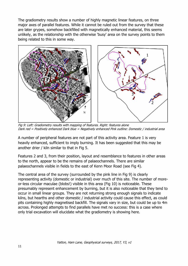
The gradiometry results show a number of highly magnetic linear features, on three
major axes of parallel features. While it cannot be ruled out from the survey that these
are later grypes, somehow backfilled with magnetically enhanced material, this seems
unlikely, as the relationship with the otherwise 'busy' area on the survey points to them
being related to this in some way.
1
3
2
Fig 9: Left: Gradiometry results with mapping of features. Right: features alone Dark red = Positively enhanced Dark blue = Negatively enhanced Pink outline: Domestic / industrial area
A number of peripheral features are not part of this activity area. Feature 1 is very
heavily enhanced, sufficient to imply burning. It has been suggested that this may be
another drier / kiln similar to that in Fig 5.
Features 2 and 3, from their position, layout and resemblance to features in other areas
to the north, appear to be the remains of palaeochannels. There are similar
palaeochannels visible in fields to the east of Kenn Moor Road (see Fig 4).
The central area of the survey (surrounded by the pink line in Fig 9) is clearly
representing activity (domestic or industrial) over much of this site. The number of more-
or-less circular maculae (blobs!) visible in this area (Fig 10) is noticeable. These
presumably represent enhancement by burning, but it is also noticeable that they tend to
occur in small linear groups. They are not returning strong enough signals to indicate
kilns, but hearths and other domestic / industrial activity could cause this effect, as could
pits containing highly magnetised backfill. The signals vary in size, but could be up to 4m
across. Prolonged attempts to find parallels have met no success: this is a case where
only trial excavation will elucidate what the gradiometry is showing here.
Yatton, Ham Lane, Geophysical surveys, 2017, Y3, v1 11
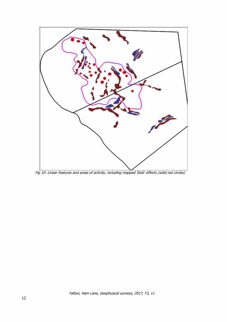
Fig 10: Linear features and areas of activity, including mapped 'blob' effects (solid red circles)
Yatton, Ham Lane, Geophysical surveys, 2017, Y3, v1 12

Resistivity survey
The resistivity results
from Simmons 1 and 2
are curiously
unrevealing. The range of responses was very
small, and as can be
seen from Fig 11, most of the low responses in
the southern field can be
completely explained by
the earthwork patterns there, which (see below)
do not reflect the Roman
landscape. In the northern field, some
curious high resistance
responses in the eastern end of the field may be
geological: the surface of
the field is slightly raised
and may form an outlier of the higher ground
around Ham Farm.
In the south-western end of the results in field 2, it is obvious that the pattern in the
southern field, of the resistivity results reflecting the surface earthworks, is continued. It
is also clear in the overlap areas that none of the gradiometry results are reflected in the
resistivity results. The curious random-like results in the northern half of the survey in this
field cannot be explained.
While a number of higher resistance features can be identified in both fields, the lack
of any response in these areas in the gradiometry survey shows they are unlikely to be
industrial or domestic in nature.
It was thus decided, in the face of the resistivity survey not producing useful
new information, to close it down at this stage.
Yatton, Ham Lane, Geophysical surveys, 2017, Y3, v1 13
Fig 11: Resistivity results in the fields with left TerraSurveyor charts (Lower field chart on left)

Earthwork surveys
Air photograph and lidar study
Detailed analysis of the air photographs of 1946-8 (in North Somerset HER) indicates
the following:
Palaeochannel Early Post-1815
Fig 12: Air photo analysis of the fields
Apart from the disturbed area at the west edge of the field, where dredging from Meadmoor
Rhyne has covered the earthworks, they survive well in the rest of the field. Aside from the
grypes (parallel blue lines), which are obviously later than the 1815 enclosure of the moor,
also the parallel grypes (pink) respecting the earlier features in brown, the small rectangular
enclosure in the south of the field by Ham Lane (magenta), and the parallel ditches
(turquoise) by the cross-roads post-date the enclosure, since they respect, and do not cross,
features created in that enclosure, such as modern Ham Lane.
The earthworks which show most effectively, and clearly pre-dating the enclosure, are
those in brown and dark green, which cut or terminate at, the natural palaeochannels
but pre-date enclosure features.
Looking at the slightly larger area on lidar plots (Fig 13) suggests that these are part of a larger
sequence of slightly radiating grypes running from the higher ground to the east of Ham Farm
out to a palaeochannel. The grypes pre-date Meadmoor Rhyne, the edge of the old enclosures
at the time of the 1815 inclosure, and also occur in a block of land called
Yatton, Ham Lane, Geophysical surveys, 2017, Y3, v1 14

Mead Moor, to the north-west of the survey area.
Fig 13: The early grype features from lidar (https://houseprices.io/lab/lidar/map) (higher land in
stipple, palaeochannels green)
This appears to be an early attempt at drainage, using the former palaeochannel (forgotten
by the time Mead Moor was enclosed, or when Meadmoor Rhyne was created) as the
terminal in the moor. There seems to be no documentation for this activity, and the land was
simply considered part of Kenn Moor by the time of the Yatton map of 1799.
The grypes do not tally with the gradiometry results in any way, so are later, and could
conceivably be late Roman. However, such attempts at draining moor which are later
abandoned, fit better with a medieval date, similar to the many upland temporary
cultivation areas, such as on Exmoor (Riley & Wilson-North 2001: 98-100) or
Minchinhampton Common in Gloucestershire (Russett 1991), or the poorly characterised
temporarily enclosed lowland areas, such as Whitesham in Nyland in Cheddar (Russett,
forthcoming). They have not so far been studied in such detail as the highland episodes.
The exact dating of this episode, however, awaits a more general study of the
multiple enclosures around Yatton and Kenn, and is beyond the scope of this report.
Yatton, Ham Lane, Geophysical surveys, 2017, Y3, v1 15

It is therefore clear from these results that the earthworks at Ham Lane cross-roads are
not themselves evidence of Roman activity. As might be expected, the picture is more
complex than this, with evidence of Roman activity, especially in the northern of the
two fields, that completely fails to correlate with the earthwork evidence.
Roman occupation, or at least, activity, is known elsewhere on Kenn Moor (see
above), and burials are known from Ham Farm (see Fig 14), but no evidence of
occupation is known.
Fig 14: Romano-British
burial at Ham Farm, found
by NSARG late 1950s, after
lid collapsed under farm
vehicles (per Dave Long)
All the evidence from
this survey seems to
indicate Roman
industrial (or just
possibly, domestic)
activity. This may
include iron working,
as has been recently
found at Arnolds
Way, Yatton (North
Somerset HER 2016)
and Cobthorn Way,
Congresbury
(Archaeological
Surveys 2015).
Yatton, Ham Lane, Geophysical surveys, 2017, Y3, v1 16
Recommendations for further work
As explained above, while the gradiometer survey provided much information, it is
very difficult to interpret, given the ground conditions and geology, and the
earthworks and resistivity survey provided no further useful information that might be
used in the interpretation.
It is therefore recommended that trial evaluation excavation be carried out to target
some of the anomalies in the northern field and to characterise and date them.
References
Archaeological Surveys 2015 Land off Cobthorn Way, Congresbury:
Magnetometer survey (Unpublished in North
Somerset HER)
Riley, H. & Wilson-North, R. 2001 The Field Archaeology of Exmoor English
Heritage
Rippon, S. 1994 The Roman landscape and settlement at
Kenn Moor, North Somerset: Interim report
on Survey and Excavation in 1993/4 in
Archaeology in the Severn Estuary 1994:
21-34
Rippon, S. 1995 The Roman landscape and settlement at
Kenn Moor, Avon: second interim report on
Survey and Excavation in 1994/5 in
Archaeology in the Severn Estuary 6: 35-47
Rippon, S. et al 2000 The Romano-British Exploitation of Coastal Wetlands: Survey and Excavation
on the North Somerset Levels, 1993-7
Britannia, Vol. 31: 69-200
Rippon, S. 2006 Landscape, Community and Colonisation:
the North Somerset Levels during the 1st to
2nd millennia AD CBA Research Report 152,
York
Russett, V. 1991 The Minchinhampton Commons,
Gloucestershire Glos. County Council I: 48
Russett, V. forthcoming And there is another island: a landscape
history of Nyland-cum-Batcombe, Somerset
Authors
Vince Russett, Chris Short May 2017
Yatton, Ham Lane, Geophysical surveys, 2017, Y3, v1 17

Appendix
Day sheet extracts - Full day sheets can be obtained on request)
Simmons 1 Gradiometry
TerraSurveyor grids above and grid layout below 18 Yatton, Ham Lane, Geophysical surveys, 2017, Y3, v1
Grid Ref. All ST
eastings northings
A 342484.30 167545.10
B 342484.50 167514.10
C 342484.60 167484.20
D 342485.20 167453.70
E 342485.70 167423.70
quiet spot 342359 167362.4
R²=0.91868
167400.00
167420.00
167440.00
167460.00
167480.00
167500.00
167520.00
167540.00
167560.00
3424
84.2
0
3424
84.4
0
3424
84.6
0
3424
84.8
0
3424
85.0
0
3424
85.2
0
3424
85.4
0
3424
85.6
0
3424
85.8
0

Simmons 2 Gradiometry
TerraSurveyor grids and below grid layout
19 Yatton, Ham Lane, Geophysical surveys, 2017, Y3, v1

Grid Ref. All ST
eastings northings
M 342483.50 167559.60
N 342482.80 167589.50
O 342482.10 167614.90
quiet spot 342470.23 167573.43
R²=0.99782
167550.00
167560.00
167570.00
167580.00
167590.00
167600.00
167610.00
167620.00
3424
82.0
0
3424
82.2
0
3424
82.4
0
3424
82.6
0
3424
82.8
0
3424
83.0
0
3424
83.2
0
3424
83.4
0
3424
83.6
0
GPS
20 Yatton, Ham Lane, Geophysical surveys, 2017, Y3, v1

Resistivity
Simmons 1
Grid layout above and TerraSurveyor grids below
21 Yatton, Ham Lane, Geophysical surveys, 2017, Y3, v1
All grids walked West except
Grid 1 28April which was East

Simmons 2
Grid layout above and TerraSurveyor grids below
22 Grid layout above and TerraSurveyor grids below
Grids walked in direction of arrows