Yanks Peak -Roundtop Mountain Area, Cariboo … of the Yanks Peak-Roundtop Mountain Area, Cariboo...
107
BRITISH COLUMBIA DEPARTMENT OF MINES HON. R. E. SOMMERS, Minister JOHN F. WALKER, Deputy Mi'nister BULLETIN No. 34 Geology of the Yanks Peak -Roundtop Mountain Area, Cariboo District, British Columbia By Stuart S. Holland Printed by DON McDua~ro, Printer to the Queen's Most Excellent Majesty VICTORIA, B.C. 1954
Transcript of Yanks Peak -Roundtop Mountain Area, Cariboo … of the Yanks Peak-Roundtop Mountain Area, Cariboo...

BRITISH COLUMBIA DEPARTMENT OF MINES
HON. R. E. SOMMERS, Minister JOHN F. WALKER, Deputy Mi'nister
BULLETIN No. 34
Geology of the
Yanks Peak -Roundtop Mountain Area, Cariboo District,
British Columbia
By Stuart S. Holland
Printed by DON M c D u a ~ r o , Printer to the Queen's Most Excellent Majesty VICTORIA, B.C.
1954


4

Geology of the Yanks Peak-Roundtop Mountain Area, Cariboo District, British Columbia
SUMMARY
1 . The Yanks Peak-Roundtop Mountain area lies at the head of several well-known placer creeks and contains numerous gold-bearing quartz veins.
2. The recorded gold production of the immediately surrounding district is 69,237 ounces of crude placer gold and 5,204 fine ounces of lode gold.
3. The area is underlain by a succession of schistose sedimentary rocks of late Precambrian and (or) Cambrian age known as the Cariboo group.
Pleasant Valley formations. These formational names have been abandoned, and the 4. Formerly the Cariboo group was subdivided into the Richfield, Barkerville, and
rocks of the Cariboo group now are divided into the Cunningham limestone, Yankee Belle, Yanks Peak quartzite, Midas, and Snowshoe formations.
5. The few intrusive rocks are dykes of diabase, diorite, rhyolite pcrphyry, and lamprophyre.
6. The rocks of the area are involved in a major syncline flanked by two overturned anticlines and in detail are intricately folded. The original structural intapretation of
must he abandoned. Bowman and Uglow of a broad, simple anticlinorium involving huge thicknmses of rock
7. The rocks are cut by northerly and northeasterly striking normal faults. Some faults have a lateral displacement of 800 feet, and in most instances the e.lstern block has dropped downward.
8. The area contains several centres of gold mineralization. 9. The localization of veins is dominantly the result of structural rather than strati-
10. The numerous quartz veins are grouped according to their strike into:- graphic factors.
(a) Northerly striking veins occupying faults or shears. ( b ) Northeasterly striking veins occupying tension fractures that may have
formed originally as extension joints but which were reopl:ned subse- quently by tensional forces resulting from movement along the northerly
(c) Easterly striking veins occupying shear fractures related to the northerly faults.
striking faults.
faults; either they occupy the fault, or they occupy northeasterly or easterly striking 11. Most quartz veins are associated in one way or another with northerly striking
fractures that are related to it. The three vein directions represent fractur,: directions that are genetically rclated, being two complementary directions of shear and the associ- ated direction of tension.
12. The quartz mineralization of the three vein directions was essentially contempo- raneous.
tion is generally sparse and consists of pyrite, galena, and sphalerite. Scheelite, arseno- 13. Ankerite is a common gangue mineral of the quartz veins. Sulphide mineraliza-
pyrite, and tetrahedrite have been found. 14. Gold is associated with pyrite, and in outcrops becomes visible when the pyrite
has been leached. 7
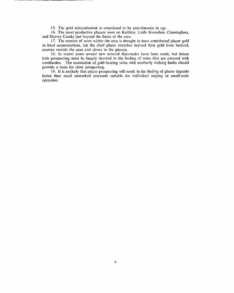
16. The most productive placers were on Keithley, Little Snowshoe, Cunningham, 15. The gold mineralization is considered to be postJurassic in age.
and Harvey Creeks just beyond the limits of the area. 17. The erosion of veins within the area is thought to have contributed placer gold
to local accumulations, but the chief placer stretches derived their gold from bedrock sources outside the area and closer to the placers.
Iode prospecting must he largely devoted to the finding of veins that are covered with 18. In recent years several new mineral discoveries have been made, but future
overburden. The association of gold-bearing veins with northerly striking faults should provide a basis for close prospecting.
better than small unworked remnants suitable for individual sniping or small-scale 19. It is unlikely that placer prospecting will result in the finding of placer deposits
operation.
8
CHAPTER 1.-INTRODUCTION
Work was started in an area around Yanks Peak as part of a programme of detailed investigations of the occurrences of lode and placer gold in the Cariboo. That particular
head of Little Snowshoe Creek; because of the area's position between .:he heads of area was selected for study because of thc presence of gold-bearing quartz veins at the
Little Snowshoe and French Snowshoe Creeks, both of which are tribntarieii of Keithley Creek, from which placer gold worth at least $976,094 has been mined;* and because
covered Barkerville area. outcrops are more numerous there than in the lower, more heavily timbered and drift-
The initial work around Yanks Peak resulted in an entirely new inte.:pretation of the geological structure and a successful unravelling of the stratigraphy, and led to the extension of detailed mapping to the northeast to include the area around the Carihoo Hudson mine and Roundtop Mountain.
LOCATION AND ACCESS
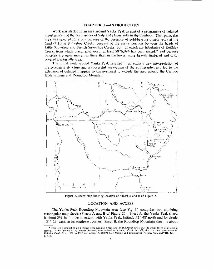
rectangular map-sheets (Sheets A and B of Figure 2) . Sheet A, the Yanks Peak sheet, The Yanks Peak-Roundtop Mountain area (see Fig. 1 ) comprises two adjoining
is about 3% by 4 miles in extent, with Yanks Peak, latitude 52" 48' north arid longitude 121" 29' west, in its southwest corner; Sheet B, the Koundtop Mountain she:et, is about
*This i? the amount of gold mined from Keithley Creek and it? tributaries since 1x74 of which there is an official record. If W ~ E estimaled by Robert Roriund, who arrived at Keithlcy Creek in 1862, that the total modwficm of Keithlcy Creek from 1860 to 1922 was about 55,000,000 (sre Mining and Engineering Record, VoI. YXV111, No. 1, p. 44).
9

4% by 5 miles in extent, with Roundtop Mountain, latitude 52" 53' north and longitude 121' 22' west, on its north border. The two sheets adjoin, and their common boundary is just east of Base Mountain. Together they cover an area of ahout 36 square miles, extending across the strike of the formations for about 11 miles in a northeasterly direction.
Sheet A of Figure 2, the Yanks Peak sheet, covers most of French Snowshoe Creek
of the head of Cunningham Creek. Sheet B of Figure 2 , the Roundtop Mountain sheet, and includes Luce Creek, the head of Little Snowshoe Creek, Aster Creek, and tributaries
includes the head of Cunningham Creek with its tributaries Peter Gulch, Pearce Gulch,
Nolaka, and Sixbee Creeks. Crazy Creek, and Copper Creek, the head of Simlock Creek, and the heads of Lostway,
The area is easily accessible either from Keithley Creek bridge, which is 74 miles by road from Williams Lake, or from Barkerville, which is 60 milcs from Quesnel.
crosses to the north side of French Snowshoe Creek, which it follows upstream to a camp From Keithley Creek bridge a road follows the east side of Keithley Creek, then
built at Snarlberg by Amparo Mining Co. Ltd. in 1939, a total distance of 11 miles from Keithley Creek bridge. From the old camp a road passable for trucks or jeeps leads
thence either to the Midas camp or to the Snowshoe camp. The old trail and wagon-road uphill to the ridge between Luce Creek and the head of French Snowshoe Creek and
leads around the southeast and south slopes of Yanks Peak from the Midas camp to the Yankee Belle camp and continues on down the west side of the mountain to join the original Keithley Creek road just above the junction of French Snowshoe Creek. Another very old trail leads from the Hebson cabin near the Hebson vein to the Haywood cabin below the forks on Little Snowshoe Creek.
son mine. The road continues a mile farther to the head of Peter Gulch, thence a tractor- From Barkerville a good road extends 18 miles southeastward to the Cariboo Hud-
road crosses the summit and extends through open timberline country a distance of 5 to 6 miles to the Midas and Snowshoe camps at the head of Luce Creek.
Simlock Creek and follows down the ridge to the east of Simlock Creek. A pack-horse trail from the Cariboo Hudson mine crosses at the very head of
easy travel on the Snowshoe Plateau. The open, park-like country at and above timberline is gently sloping and provides
PREVIOUS WORK
The report on the first geological work in the Cariboo by Amos Bowman was pub- lished by the Geological Survey of Canada in the Annual Report for 1887-88, Vol. 111, Part I. Bedrock geology is shown on the map accompanying this report on a scale of
Keithley Creeks* are shown on a scale of about 1 inch to 2,100 feet, and on Cunningham 1 inch to 2 miles. Details of the quartz veins and placer mines on Little Snowshoe and
Creek? on a scale of about 1 inch to 1,800 feet. Bowman mapped a major anticlinorium lying to the east of Yanks Peak and extending far to the northwest, and indicated by his structure section that the axial planes of the individual folds were inclined. Subsequent maps by several members of the Geological Survey of Canada show the axis of the original anticlinorium in much the same position as it was first mapped. This structural concept,
ping and beliefs. originating with Bowman, exercised a strong influence upon subsequent geological map-
Uglow mapped the Barkerville area in 1922,$ and in 1933 and 1934 Hansons worked in greater detail along the Barkerville Gold Belt a few miles to the northwest of the present area. Lang worked between Yanks Peak and Roundtop Mountain while
* Geol. Surv., Canodn, Map 369, 1895.
f Geol. S u n . , Canndo. Memoir 149. 1926. T Geol. Surv., Canada, Map 368, 1895.
0 Grol. Surv., Canada, Memoir 181, 1935.
mapping the Keithley Creek map-area in 1935 and 1936. The reports b y Lang,* and the Keithley Creek map? published on a scale of 1 inch to 1 mile, contain much material
and of placer deposits are contained in various Annual Reports of the Minister of Mines, descriptive of the area and of the mineral showings. Additional descriptions of lode
British Columbia, from 1874 to 19.52.
BIBLIOGRAPHY
1. Benedict, P. C. ( 1 945) : Structure at Island Mountain Mine, C.I.M.M., Trans., Vol.
2. Bowman, Amos (1889): Report on the Mining District of Cariboo,, Geol. Surv.,
__ (1895): Maps of the Principal Auriferous Creeks in the Cariboa, Geol. Surv.,
3. Hanson, George (1935): Barkerville Gold Belt, Geol. Surv., Canada, Mem. 181. 4. Holland, Stuart S. (1948) : Report on the Stanley Area, B.C. Depf . o; Mines, Bull.
5. Noway, F. W., and Scholefield, E. 0 . S. (1914): British Columbia from the Earliest
6. Johnston, W. A,, and Uglow, W. L. (1926): Placer and Gold Depos:.ts of Barker-
7. Lang, A. H. (1937): Keithley Creek Map Area, Geol. Surv., Canada, Paper 36-15. __ (1939): Keithley Creek Map Area, Geol. Surv., Canada, Paper 38-16.
Canada, Trans., Vol. XLI, Series 111, Sec. 4, pp. 29-35. __ (1947): On the Age of the Cariboo Series in British Columbi,a, Roy. Soc.,
8. Skerl, A. C. (1948): Geology of the Cariboo Gold Quartz Mine, Ec. Geol., Vol. XLIII, No. 7, pp. 571-597.
9. Sundell, I. G. (1937): Fineness and Composition of Alluvial Gold from Ivalojoki, Finnish Lapland, Bulletin de lu Commission Ceologique de Finland, Vol. XIX, No. 115, pp. 155-160.
XLVIII, pp. 755-770.
Cunudu, Ann. Rept., 1887-88, Vol. 111, Pt. 1, Pt. C .
Canada, Maps 364-372, 1895.
No. 26.
Times, S. J . Clarke Publishing Co.
ville, G e d . Surv., Canada, Mem. 149.
PRESENT WORK
This report is based on the following field work: a ten-day preliminary examina-
weeks from June to September, 1949; ten weeks from July to September, 1950; and tion of the area in August, 1947; six weeks in August and early September, 1948; twelve
nine weeks in July and August, 1951. The writer was assisted in 1947 by W. H. Poole,
McGregor, in 1950 by W. Holyk and C. A. McGregor, and in 1951 by A . Sutherland in 1948 by D. Aitkens and W. D. McCartney, in 1949 by W. D. McCartmy and C. A.
Brown and G. E. Apps. No maps were available for plotting on the field scale of 1 inch to 4-00 feet, and
consequently a base map was prepared by using as main control points the geographical positions of the triangulation-survey stations named Yanks, Aster A, Aster I), Harvey A, Harvey B, French Snowshoe, Roundtop, Middle, Bee, and Cunningham S. The posi- tions of these and of the corner posts of the surveyed mineral claims were plotted from their co-ordinate locations to ensure over-all accuracy. All these points are marked
chain and compass, and plane-table traverses, tied wherever possible to surveyed claim and can be found on the ground. Details of roads, trails, creeks, etc., were added from
posts or fixed geographical points. Contour lines on the base map were derived largely from form lines transferred
from vertical aerial photographs and controlled by ground elevations obtained from
from plane-table field sheets. altimeter readings corrected with reference to one or more of the geographic points, and
t Geol. surv., Canada. Map NO. 5 6 2 ~ . Gaol. Surv., Canada, Papers 36-15 and 3816.
11
plane-table surveys tied in at frequent intervals to known locations. These traverses Geological observations were located by closed chain and compass traverses, or by
were plotted on the base map on a scale of 1 inch to 400 feet. A small area of extreme structural complexity, on the southeast slope of Yanks Peak, was mapped by plane-table and stadia on a scale of 1 inch to 100 feet, and an area northeast of Yanks Peak explored by bulldozed trenches was mapped by tape and compass on a scale of 1 inch to 100 feet.
creeks, and ridges were traversed. Additional traverses were made along formational To provide the framework of geological information, all roads, trails, claim lines,
contacts or for special purposes. Because of the extraordinarily good weather during the summers of 1950 and 1951 most of the country around Roundtop Mountain was mapped by plane-table, whereas inferior weather in 1948 and 1949 necessitated map- ping the Yanks Peak area almost entirely by chain and compass traverses.
Yankee Belle, Cornish Ledges. and other veins was all done by plane-table and stadia Detailed mapping of the workings on the outcrops of the Snowshoe, Jim, Midas,
on a uniform scale of 1 inch to 40 feet. Transit surveys of the three adits of the Snowshoe mine and of the underground
workings of the Cariboo Hudson mine were available. Underground geology was plotted
Midas adit and Jim adit and plotted on a scale of 1 inch to 20 feet to provide a base for on these on a scale of 1 inch to 20 feet. Chain and compass surveys were made of the
mapping the underground geology. The magnetic declination was taken to be 26 degrees east of north.
PHYSICAL CHARACTER OF THE AREA
zone between the high, extremely rugged Cariboo Mountains on the east and the lower, The Yanks Peak-Roundtop Mountain area lies near the western side of a transition
wooded, concordant summit areas of the Fraser Plateau on the west (see Plates I (A) and I (B) showing views looking east and west). The area is at the dividc between creeks flowing into Keithley Creek, Harvey Creek, Antler Creek, and Cunningham Creek. It includes part or most of French Snowshoe, Liltle Snowshoe and its tributary Luce Creek, Peter Gulch, Pearce Gulch, Copper, Crazy, Simlock, Lostway, Nolaka, and Sixbee Creeks.
The several high points in the area are Roundtop Mountain, Middle, Base Moun- tain at triangulation station Harvey A, and Yanks Peak. 'The extreme differences in elevation are between Yanks Peak at 6,242 feet elevation and French Snowshoe Creek at about 4,000 feet elevation, and between Roundtop Mountain at 6,163 feet elevation
foot contour. and Cunningham Creck at 4,200 feet elevation. Most of the area lies above the 5,000-
Yanks Peak, though not the highest point, stands out prominently mainly because it dominates its immediate surroundings (see Plate I1 (A) ) . I t slopes steeply southward
Hollow and the next basin to the west evidently were occupied by cirque glaciers whose into French Snowshoe Crcek, and drops off abruptly northward into Luce Creek. Jews
steepened headwalls account for the abrupt north face of the peak.
south (see Plate I11 ( A ) ) . From other directions the peak appears only as the culmina- Roundtop Mountain displays its characteristic mesa-like top when viewed from the
tion of a long, gradually sloping ridge. Flat-topped ridges and gentle open slopes above 5,500 feet elevation connect the
high points and slope downward into the several valleys. The upland area between Cun- ningham Creek and Yanks Peak is locally called the Snowshoe Plateau (see Plate 111). This upland surface extends northeastward past the Cariboo Hudson mine to the long ridge running southeastward from Roundtop Mountain.
Cunningham, and Simlock Creeks have narrow bottoms and moderately to steeply flaring Despite their having been glaciated, the valleys of French Snowshoe, Little Snowshoe,
heavily timbered. On them outcrops are few and are scattered at random. Above 5,500 sides (see Plate I ( A ) ) . The valley slopes, up to about 5,500 feet elevation, are fairly
12
feet elevation the timber is patchy and open areas increase in size as timberline is
between French Snowshoe and Cunningham Creeks, and between Copper and Lostway approached. The divide areas between the heads of Little Snowshoe and Aster Creeks,
and Nolaka Creeks are open expanses of alpine meadow.
underlain by hard, more resistant beds, nor are they particularly abundant along the valley Rock outcrops on the upland areas are not particularly abundant except along ridges
bottoms. For mapping on a 400-foot scale the outcrops in many parts are not adequate, and most dependence, therefore, has been placed on areas of outcrop found above 5,500 feet elevation.
The resistance to erosion of different rocks is reflected in varying degrees by the topography. The extremely hard, massive, and silicified Yanks Peak quartzite forms prominent outcrops, and its position accounts for the height and location cf Yanks Peak as well as of Roundtop Mountain and the other high points along strike to the southeast. Massive quartzite of the Snowshoe formation forms widespread outcrops 017 Base Moun- tain and to the northeast, on the ridge north of Aster B, and east of the head of Little Snowshoe Creek; whereas softcr, fissile rocks such as sericite schist, argillaceous schist, and quartz sericite schist outcrop poorly and for the most part occupy depmsions between ribs of harder quartzite.
of glacial erosion are to he seen in the cirque basins on the north side of Yanks Peak and The area was covered by glacial ice to the summits of the highest peak:;. The effects
on the northwest side of Roundtop Mountain, and in the steepened sides and heads of Lostway and Nolaka Creeks and of Aster Creek and Holmes Basin. Breakneck Ridge, lying between the last two, is well named. The valleys of all creeks were glaciated hut to varying degrees. At several places on Cunningham Creek and near the heads of Little Snowshoe and French Snowshoe Creeks boulder clay lies directly on smooth, glaciated bedrock. In the lower stretches of Little Snowshoe Creek ice did not scour the bottom of the valley. There, gravel lies beneath boulder clay, and pre-glacial placer deposits were not dispersed. The results of glaciation are to be seen in the widespread mantle of boulder clay and glacial drift which covers bedrock in the valley bottoms and on th,: lower valley slopes and which effectively hides bedrock over much of the area. That glacial ice at one stage moved in a southerly or southwesterly direction is indicated by the presence of a glacial erratic of rhyolite porphyry on the ridge northwest of Yanks Peak. The only known outcrops of such rock are at the head of Luce Creek and on Horseshoe Nail Gulch to the northeast and north.
13

CHAPTER I I . 4 E N E R A L GEOLOGY
INTRODUCTION
The gold-mining region of the Cariboo lies within an area 18 miles wide by at least
Valley Creek on the northwest. All this area is underlain by the Cariboo group of schis- 40 miles long, extending from Cariboo River on the southeast to Willow River and Big
porphyry, lamprophyre, diabase, and diorite. tose sedimentary rocks. Intrusive rocks are rare and comprise a few dykes of rhyolite
On the northeast, in a large synclinal area, the Cariboo group is unconformably overlain by the Slide Mountain group of Mississippian age and on the southwest is uneon- formahly overlain by the Quesnel River group of Jurassic age. To the southeast, on Kim- hall Creek, rocks that have been correlated by Lang with the Cariboo group are stated hy him* to be overlain, apparently conformably, by Lower Cambrian beds. Furthermore, Cambrian fossils have been found by A. Sutherland Brown in limestone beds on Turks Nose Mountain. At this stage it is uncertain whether the Cariboo group is late Precam- brian, or wholly or in part Cambrian in age.
In the Barkerville area the Cariboo group was divided by Uglowt from oldest to youngest into a dominantly quartzitic succession, the Richfield formation; a dominantly limestone succession, the Barkerville formation; and a dominantly argillaceous succes-
the geological mapping was extended into the Cariboo Mountain, Keithley Creek, and sion, the Pleasant Valley formation. This threefold subdivision was used by Lang when
Little River areas (see Geol. Surv., Canada, Maps 561~, 5 6 2 ~ , and S 6 3 ~ ) . The Yanks Peak-Roundtop Mountain area is entirely underlain by rocks of the
Cariboo group, but the former threefold subdivision was found to be an unsatisfactory basis for mapping. Field work in the vicinity of Roundtop Mountain unquestionably demonstrates that the limestone mapped there by Uglowi and Langs as Barkerville for- mation underlies rather than overlies the Richfield formation, and that the rocks mapped there as Pleasant Valley formation rather than being a conformable succession of uni- formly facing beds are actually argillaceous rocks and other members of the Richfield formation, repeated by complex folding on the northeast side of a major anticline. More- over, between Yanks Peak and Base Mountain the rocks were mapped by Langl! as undivided Richfield formation lying conformably beneath his subdivisions of the upper Richfield. The present structural interpretations are incompatible with Lang's concept and indicate that the Hudson, Bee, Roundtop, and Lostway members have no strati- graphic entity, and that these members which he described and mapped near the Cariboo Hudson mine are actually repetitions by folding of rocks that outcrop near Yanks Peak.
It became apparent during the course of the work that the stratigraphy and mapping of the Cariboo group should be completely revised. As a consequence, the former three-
The detailed mapping has been extended between Roundtop Mountain and Island Moun- fold subdivision of the Cariboo group was abandoned and a fivefold division substituted.
tain by A. Sutherland Brown, and the results of his work, to be published in a forthcoming bulletin of the Department of Mines, will supplement this report.
Within the present area the structure is so intricate that a detailed knowledge of the stratigraphy was acquired only as the complexities of both the regional and detailed fold structures became apparent. The age succession was not established on the basis of primary sedimentary structures. The complex, isoclinal folding makes it incorrect to
was worked out almost entirely by interpretation of minor secondary structures such as assume that a bed faces in the same direction that it dips, and consequently the succession
dragfolds and cleavage-bedding relationships (see Plates V (A) and V ( B ) ) , tested * O l d Surv.. C o d a . P a ~ e r 38-lh. I). 13. , ~~~~~~~ . . ~~
t Gaol. Sum., Conoda, Mem. 149, p. 12. I Gsol. Surv., Canada, Mem. 149, p. 11 and Map 2046. B Geol. Surv.. Conodo, Paper 38-16. P. 10 and Map 562*,
..
i Geol. Sur"., Conodo. Map 5 6 2 ~ . Keithley Creek.
14

against the simultaneous interpretations of the larger fold structures. Graded bedding and cross-bedding (see Plate IV ( A ) ) are not widespread and where observed only served to confirm the age relationships determined structurally.
In the Yanks Peak-Roundtop Mountain area the Cariboo group is divided into five major map units. These are, from oldest to youngest, the Cunningham limestone, light
grey argillaceous slates, silty quartzites, and chlorite schists; the Yanks Peak quartzite, grey to cream thick-bedded limestone; the Yankee Belle formation, comprihg olive and
prising grey and black siltstones, slates, and schists, and some black limestone, and a prominent bone-white or pale-grey dense massive quartzite; the Midas formation, com-
characterized by the presence of black silty quartzite;* and the Snowshoe formation, comprising a basal pebble conglomerate, grey gritty quartzite, quartz swicite schist, chlorite schist, and light-grey limestone. The base of the Cunningham limestone is not exposed in the area, nor is the top of the Snowshoe formation.
thickening of stratigraphic units by repetitive isoclinal folding. For example, the Midas One of the most noticeable effects of the complex structure is a tremendous apparent
upper black silty quartzite, which is about 25 feet thick, is folded into accordion-like pleats about essentally horizontal axes and nearly vertical axial planes so that it outcrops along the ridge north of the Snowshoe mine camp across a width of about 900 feet. On Base Mountain, northeast of Harvey A, a hand of coarse grey grit is repeated at least six times in a distance of ahont 2,500 feet across the strike. On the east rim of Jews Hollow a band of Midas black silty quartzite is repeated seven times in a distance of about 1,000 feet between the Yanks Peak quartzite and the Saddle shaft. In that distance there are three minor but distinct anticlinal axes. On Horseshoe Nail Gulch the ha:jal Snowshoe conglomerate is repeated in long narrow outcrops that are the keels of three synclines. The members of all units are thickened to an almost unbelievable extenl, and conse- quently an estimate of the true thickness of any unit can be made only after most of the
the structure was not understood. structural details are known. Previous estimates must have been quite empiIicalt because
*This rock properly should be named a mefasiltStOne but herein is called r silty quartzite. The qllarfz grains are
tGsol. Surv.. Canada, Ann. Rept. 1887-88, Val. 111, Pt. I, Pt. C, 1889, p, 24c: Mem. 149, pp. 33. 34; Paper of silt size.
38-16, p. IO.
15
Intrusive rocks. I Dykes of rhyolite porphyry, lamprophyre, diabase, and diorite. I Intrusive contact
8 6:
3
Yanks Peak Grey Lo while, dense. fine~giained silicified quartzite, in places gritty 50 to quartzite. 200 or almost a pea~pebble conglomerate.
m
YanlreeBelle Lixht~grey tu brown phyllite wifh interbedded quartzite, chlorite
900 Peak by Presence of numerous smoky~grey quartz ~cinlefs. to schist, characlerired by absence of black silty quartrile and at Yanks
500
formation.
I
I Cunningham ' Finc~graincd, grey to black limes ton^ largely bleached light grey to
limestone. 1 cream with thin chloritic interbeds in the upper 50 r e t . I 'loo least
SEDIMENTARY ROCKS
CUNNINGHAM LIMESTONE
exposed and its top is the last limestone bed below a succession of chlorite schists which The Cunningham limestone is the oldest formation in the area. Its base is not
conformably overlies it. Cunningham limestone is exposed in a single continuous northwesterly striking belt
about 7,000 feet wide, lying on the northeast side of Roundtop Mountain and Middle and extending beyond the limits of the area.
cream coloured on weathered surfaces. The upper 50 feet or so consists of thinly bedded The formation is almost entirely limestone, which is fine-grained and is light-grey to
calcareous and chloritic layers (see Plate VI1 (B) ) . The chloritic beds weather more readily, leaving inch-thick ribbons of limestone in relief. Most of the underlying beds are thick-bedded and may contain chert in nodules and hard irregular masses.
The original limestone appears to have been dark grey to black and to have been bleached to very pale grey in areas that are definitely related to fractures and quartz veins. The bleaching was followed by the addition of iron which combined to form carbonates which on weathering impart a pale-cream to light-buff or brown colour to the rock. There has been some recrystallization and coarsening of the grain texture.
the area. The greatest thickness observed is about 400 feet. The full thickness of the formation is not known since its base is not exposed within
dragfolds, but below this zone the outlines of the folds are smoother and the folds them- The top thinly bedded 50 feet of the formation is rather intensely folded into minor
selves are larger than in the overlying formations. The shapes of the folds in the Cun- ningham limestone differ from those in the younger formations. It is possible that this limestone, at least as f a r southwest as Yanks Peak, may have formed a basement to the
16

intense folding of the overlying rocks, because no Cunningham limestone i!i seen in the cores of the anticlines at Bee and Yanks Peak.
ville formation and is shown as conformably overlying the rocks that are on the south- On Geological Survey Map 5 6 2 ~ the Cunningham limestone is map@ as Barker-
west side of it. In actuality, the formation is fairly thin and is involved in a major complex anticline which spreads the outcrops across a width of 7,000 feet or more. The name Barkerville formation has been abandoned because the unit as originally described by Uglow no longer exists. Moreover, it is believed that on Uglow's map of the Barker- ville area (Geol. Surv., Canudn, Map 2046) limestones from several stratigraphic hori- zons were correlated and mapped as Barkerville formation.
YANKEE BELLE FORMATION
The Yankee Belle formation conformably overlies the Cunningham limestone and in turn is overlain by the Yanks Peak quartzite.
It outcrops in four separate areas: in the core of an anticline in an area on the south and west slopes of Yanks Peak and in the canyon of French Snowshc'e Creek; in the core of an anticline in an area extending northwest from Bee; and in two strips flanking the anticlinal outcrop of Cunningham limestone and lying northeast o f Roundtop Mountain and Middle and southwest of Cunningham S. Its stratigraphic position below the Yanks Peak quartzite was first deduced from its structural position in tht: core of the Yankee Belle anticline. Correlation of the isolated outcrop areas is based on analysis of the structure and knowledge of the lithologic sequence.
The top of the formation lies at the base of the first hard white massive quartzite of the overlying Yanks Peak quartzite, and its base includes the lowest chlorite schist that overlies Cunningham limestone.
quartzites, grey argillaceous and sericitic schists, and lesser amounts of grey quartzite. Near Yanks Peak the Yankec Belle formation consists dominantly of grey silty
On the trail from the Midas claims to the Yankee Belle camp a characteris;:ic rock is a light-grey brownish-weathering quartzite, thinly laminated with grey silty quartzite and argillaceous schist. An almost complete section is exposed in the canyon on French Snowshoe Creek downstream from where the Yanks Peak quartzite crosses the creek at J. Sockett's mineral showing. The rocks are fairly uniform and are predominantly dark- grey fine silty quartzite, and argillaceous schist and slate. They have light-coloured laminations as much as an eighth of an inch thick which may he either ankerite or quartz-
near the Yankee Belle adit the rocks contain scattered pyrite cubes as much as half an ankerite veinlets lying parallel to the schistosity. In the upper part of the canyon and
inch across. As a general rule, the rocks weather to a light brown except on the main road helow Snarlberg, where outcrops of grey slates and grey slaty argilla8:eous rocks
above the Yankee Belle camp, the Yankee Belle rocks contain numerous smoky-grey are not unlike some members of the Midas formation. On the slopes of Yanks Peak
quartz veins and lenticles, of which some crosscut the foliation and some are parallel to it. This smoky vein quartz is exceedingly common and appears to be restricted to the Yankee Belle formation and the overlying Yanks Peak quartzite.
from those of the Midas formation. The main lithologic characteristic is the presence of Rocks of the Yankee Belle formation are not everywhere readily disr.iuguishable
black silty quartzite in the Midas formation and its absence from the Yankec: Belle. In the vicinity of Roundtop Mountain the lowest part of the Yankee Eklle forma-
tion is fine-grained thinly bedded chlorite schist. This rock grades upward into a lustrous light-grey to brown phyllite which weathers to a characteristic celadon (brownish grey- green) colour. The next sequence comprises phyllite with interbeds of :he-grained brown quartzite as much as 10 feet thick. The uppermost rocks are celadcn and grey phyllites containing a few quartzitc beds. Some of these upper quartzite beds are similar to Yanks Peak quartzite, and possibly the two formations interfinger.
17

Cunningham limestone and in the core of the Bee anticline, but not elsewhere. They Highly chloritic rocks of the Yankee Belle are seen in conformable contact with the
are believed to reflect the composition of the original rocks rather than areas of higher metamorphic grade.
from which an alteration spreads out into the wallrock. Jn some instances the entire Near Yanks Peak grey silty quartzites are crossed by narrow white quartz veinlets
rock-mass is altered to a drab olive-green colour. Because of structural complexities and lack of outcrops the complete structure of
the Yankee Belle succession was not worked out. As a consequence, a close estimate of the thickness is not possible. The total thickness cannot he more than 900 to 1,000 feet and in all probability is about 400 to 500 feet. On Lostway Creek chloritic schist
phyllite is probably not more than 50 feet thick and the phyllite and quartzite succession about 150 feet thick is exposcd in an uncomplicated dragfold. The uppermost grey
may he only 200 to 300 feet in total thickness.
results from the marked difference in competence between them and the underlying fairly The exceedingly complex pattern of folding in the Yankee Belle beds undoubtedly
thick Cunningham limestone and the overlying hard competent Yanks Peak quartzite. On the northwest side of Roundtop Mountain and elsewhere the amplitude of folds of quartzite beds in the Yankee Belle is seen to be very much greater than that of folds in the immediately overlying Yanks Peak quartzite. In several instances tight anticlines 15
ingly thin papery phyllite near the apices of folds in the Yankee Belle emphasizes the fact or 20 feet across have isoclinal limbs 50 to 100 feet long. The development of exceed-
that large amounts of movement have taken place. In the Yankee Belle and Bee anti-
from the Cunningham limestone which underlies them at unknown depth. clines the tightly compressed cores of Yankee Belle formation have evidently pulled away
The Yankee Belle formation includes the “green schistose argillite” which Lang* placed in the Lostway member.
YANKS PEAK QUARTZITE
provides an extremely valuable horizon for outlining the complex folds. It lies conform- The Yanks Peak quartzite is an easily recognizable light-coloured quartzite which
ably above the Yankee Belle formation and below the predominantly dark-coloured Midas formation. The rock is prominently exposed on the summit and flanks of Yanks Peak, where it is involved in exceedingly intricate folding. The outcrop of the bed has a horseshoe-like trace which outlines the northwesterly plunging Yankee Belle anticline.
not outcrop there. The formation is widely distributed across a width of 2,000 to 3,000 Similarly, it should outline the anticline at Bee, but so far as could be determined it does
feet in a belt extending northwest and southeast of Roundtop Mountain.
in colour but in most places light grey to bone white on weathered surfaces. The forma- The Yanks Peak quartzite is an essentially uniform quartzite, medium to dark grey
tion in places has thin interbeds of dark slaty material which increase in number toward the Yankee Belle and Midas contacts. At its base the quartzite in several places shows a noticeable coarsening to gritty material or to a pea-pebble conglomerate. The coarser material is cross-bedded with a small angle of truncation of the beds. It is possible that the cross-bedding is more widespread hut is masked by the general silicification that the formation has undergone. In some places the rock appears almost like vein quartz. At
in the underlying Yankee Belle formation. Yanks Peak the formation is crossed by numerous smoky-grey quartz stringers like those
The quartzite is extremely hard and massive and forms bold outcrops on Yanks Peak, Roundtop Mountain, Middle, and other prominent points whose height results from the rock‘s resistance to erosion.
be increased several fold, or may be greatly reduced. For long stretches the formation Where the formation is involved in complex folding, its apparent thickness may
18 * Geol. Sur?., Conadn, Pawr 38-16, P. 8 .

is absent and the Yankee Belle formation is in contact with the Midas. On Yanks Peak the formation outcrops in areas that are arranged like a string of irregular11 sized beads or like links of sausage. At least i n part the formation has hecn stretched, thinned, and completely torn apart, and illustrates boudinage on a huge scale. In other places it is believed that the absence of the formation and differences in thickness are depositional features.
Near Yanks Peak the formation is 50 to 100 feet thick. At the Simlock fault it is about The Yanks Peak quartzite ranges in thickness from a few feet to about 200 feet.
200 feet thick, at the crests of Roundtop Mountain and Middle it is 125 to 150 feet, hut on the limbs of folds it is about 50 feet, on the northeast limb of the easternmost syncline on Roundtop Mountain, Middle, and on the ridge between Nolaka and Sixbee Creeks it is from 2 to 10 feet thick.
crop was traversed throughout most of its length and it was mapped in greater detail than The Yanks Peak quartzite was found to he an extremely valuable marker; its out-
were the other formations. In this way the Yankee Belle anticline was resolved and the
lished. The stratigraphic position of the Cunningham limestone was confirmed through stratigraphic succession of the Yankee Belle, Yanks Peak, and Midas formations estah-
knowledge of the fold structure outlined by the Yanks Peak quartzite.
regional folding. It was dragfolded, in many instances very tightly (see Plate VIII), hut Because of its competence the formation was a modifying factor in the type of
in general more gently than either the underlying Yankee Belle or overlying Midas forma- tions. The general form of the folds outlined by Yanks Peak quartzite could be deter- mined in most instances from the trace of the formation, and although the major folds persist along strike, with some modification of shape, innumerable minor folds die out and are replaced by others. Commonly the formation is torn apart at inflexion pcmints, allow- ing greater flowage in the surrounding rocks. As a consequence of the flowage, small structures are formed near by that are far more complex than those in the Yanks Peak quartzite.
nected areas of exposure of Yanks Peak quartzite on Yanks Peak and between Roundtop An important element of the regional structure is the correlation of the 'two uncon-
Mountain and Sixbee Creek. The correlation is based on lithology and on s!udy of the stratigraphic sequence in conjunction with major fold structure.
The Yanks Peak quartzite was mapped by Lang" as part of the Roundtop member.
MIDAS FORMATION
argillaceous rocks lying conformably above the distinctive Yanks Peak quart:dte and in The Midas formation is essentially an assemblage of grey and black, dominantly
turn overlain by basal conglomerate or grit of the Snowshoe formation. The Midas formation envelops the horseshoe-shaped trace of the Yankee Belle
anticline and outcrops in a number of narrow parallel ribbons to the southwest of Base Mountain. It occurs as a single band 7,000 feet wide southwest of Roundtop Mountain and Middle, and occupies synclinal troughs to the northeast.
Near Yanks Peak In the vicinity of Yanks Peak, details of Midas stratigraphy are known largely
through detailed mapping of the Midas bulldozed cuts (see Fig. 1 1 and p. 29). Although
was not possible. Because the folding is exceedingly complex and outcrop:; are few, a considerable amount of time was devoted to this work, an entirely satisfactoly solution
several interpretations are possible. One is that two anticlines lie between the Saddle shaft and the Midas-Snowshoe contact. This interpretation requires that thc outcrops of black fine-grained silty quartzitet probably represent the traces of three separate bands of rock.
* Gcol. Sur".. Canado, Paper 38-16, P. 8 . t This rock could be called metasiltstone. The constituent quam srains are of silt size.
19
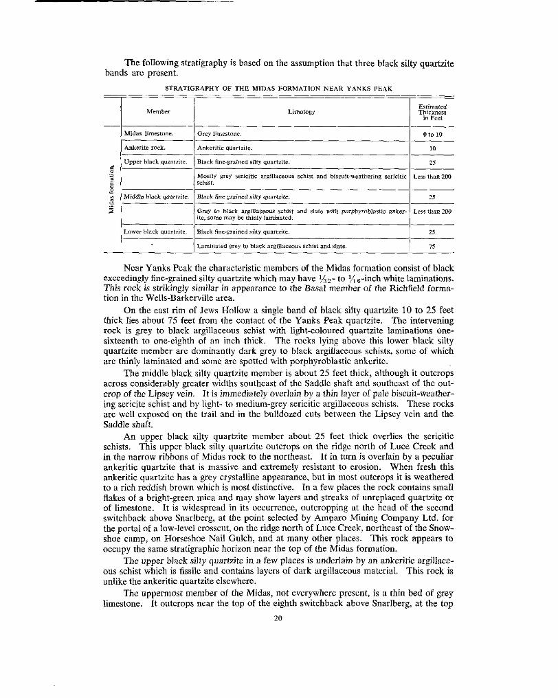
hands are present. The following stratigraphy is based on the assumption that three bIack silty quartzite
STRATIGRAPHY OF THE MIDAS FORMATION NEAR YANKS PEAK
! Member Lithology Estimated Thickness
in Feet
I 1 Laminated grey to black argiliaceous Schist and slate. I 75 - Near Yanks Peak the characteristic members of the Midas formation consist of black
exceedingly fine-grained silty quartzite which may have l/n2- to % &ch white laminations.
tion in the Wells-Barkerville area. This rock is strikingly similar in appearance to the Basal member of the Richfield forma-
On the east rim of Jews Hollow a single band of black silty quartzite 10 to 25 feet thick lies about 75 feet from the contact of the Yanks Peak quartzite. The intervening rock is grey to black argillaceous schist with light-coloured quartzite laminations one- sixteenth to one-eighth of an inch thick. The rocks lying above this lower black silty quartzite member are dominantly dark grey to black argillaceous schists, some of which are thinly laminated and some are spotted with porphyroblastic ankerite.
The middle black silty qnartzite member is about 25 feet thick, although it outcrops
crop of the Lipsey vein. It is immediately overlain by a thin layer of pale biscuit-weather- across considerably greater widths southeast of the Saddle shaft and southeast of the out-
ing sericite schist and by light- to medium-grey sericitic argillaceous schists. These rocks are well exposed on the trail and in the bulldozed cuts between the Lipsey vein and the Saddle shaft.
schists. This upper black silty quartzite outcrops on the ridge north of Luce Creek and An upper black silty quartzite member about 25 feet thick overlies the sericitic
in the narrow ribbons of Midas rock to the northeast. It in turn is overlain by a peculiar ankeritic quartzite that is massive and extremely resistant to erosion. When fresh this
to a rich reddish brown which is most distinctive. In a few places the rock contains small ankeritic quartzite has a grey crystalline appearance, but in most outcrops it is weathered
flakes of a bright-green mica and may show layers and streaks of unreplaced quartzite or
switchback above Snarlberg, at the point selected by Amparo Mining Company Ltd. for of limestone. i t is widespread in its occurrence, outcropping at the head of the second
the portal of a low-level crosscut, on the ridge north of Luce Creek, northeast of the Snow- shoe camp, on Horseshoe Nail Gulch, and at many other places. This rock appears to occupy the same stratigraphic horizon near the top of the Midas formation.
ous schist which is fissile and contains layers of dark argillaceous material. This rock is The upper black silty quartzite in a few places is underlain by an ankeritic argillace-
unlike the ankeritic quartzite elsewhere. The uppermost member of the Midas, not everywhere present, is a thin bed of grey
limestone. i t outcrops near the top of the eighth switchback above Snarlberg, at the top 20

of the road leading down to the Midas Camp, on the ridge north of Luce Creek, and in the small creek flowing southward into the head of Little Snowshoe Creek. The limestone bed probably is not more than 10 feet thick. Its absence in many places rnay indicate
conglomerate. either a lack of deposition or an erosional unconformity helow the basal Snowshoe
Near Roundtop Mountain
as mapped near Yanks Peak. In general, however, it is likewise an as!;emblage of The Midas formation near Roundtop Mountain differs in detail from the formation
dominantly black argillaceous and quartzitic rocks with a bed of black limmtone at its very top. The correlation of the Midas formation near Roundtop Mountain and Middle with similar rocks to the southwest is based on the interpretation that the secticln southwest of the Yanks Peak quartzite on Roundtop Mountain and Middle is overturned.
rather characteristic light- to dark-grey finely handed siltstone or fine silly quartzite. The basal Midas is a grey, rusty-weathering phyllite which in turn is overlain by a
Typically this rock is cross-bedded (see Plate IV ( A ) ) , the beds bcing truncated at an
laceous quartzites. At the top of the formation is a black limestone bed, possibly 25 angle of about 30 degrees. Overlying it are black slates and black fine-glained argil-
feet thick, well exposed above the bridges on Copper Creek, northeast of the Bralco cabin, and in Simlock Creek. The limestone that outcrops widely in a belt northeast of the Bralco cabin is a single bed repeated many times by isoclinal folding.
On Bee, in the cirque at the head of Nolaka Creek, and at several other places are
upper Midas quartzite at Yanks Peak. outcrops of reddish-brown weathering ankeritic quartzite similar to the rock above the
Although the upper Midas limestone was originally black, in most outcrops it is now light grey, mottled, or is sli&tly buff weathering. The black limestone has been
exist between black and white. In some instances iron carbonate has been introduced bleached and altered along cracks and fractures so that all intermediate mottled stages
and a pale-cream or huff colour is imparted to the limestone on weathering.
numerous large ankerite porphyroblasts. Near the diorite dyke on Middle the ankeriti- The Midas rocks have been ankeritized more than any others, and may contain
zation has been moderately intense. The Midas formation is as intensely deformed as the Yankee Bellc. It lies between
the more competent Snowshoe formation and the underlying Yanks Peak quartzite, and has accommodated itself by folding and flowage to outlines imposed upon it by the stronger rocks. Even though the rocks are reasonably well exposed northemt of Yanks Peak, the internal structures are far too complex for prccise delineation from information available. Near Middle the lower thinly bedded siltstone forms relatively 1arg:e dragfolds which are enveloped by tight isoclinally folded slate and papery schists. The upper limestone, being easily recognizcd, is seen to he widely distributed and to be closely and repeatedly folded.
ankeritc rock, or limestone. In part this may he the result of beds having hem squeezed The top of the Midas formation may be either the upper black silty quartzite,
out during intense folding or, altcrnatively, it may indicate a period of erosion before the deposition of the basal Snowshoe conglomerate.
Yanks Peak quartzite. The true thickness of the formation cannot be closely determined. The base of the formation is at the lowermost black slate or phyllite resting upon
In the bulldozed cuts on the ridge northeast of Yanks Peak a thickness of abcmut 500 feet
an interpretation of exposures there indicates that the total thickness of the: formation is apparent, whereas along French Snowshoe Creek near the southwest corner of the area
uncomplicated sections of the Midas. It is estimated, however, that the total thickness may he only about 300 feet. Near Roundtop Mountain there are no complete and
is 400 feet or slightly more. 21

included by Lang* in the Lostway member, the " black, fissile argillite " of the Bee The Midas formation includes " black to dark grey massive and fissile argillites "
member, and also the limestone and argillite included by Lang in the upper Hudson member.
SNOWSHOE FORMATION
The Snowshoe is a dominantly quartzitic formation that includes the youngest sedimentary rocks in the area. Its base is a conglomerate or coarse grit lying above the upper Midas limestone and its top is not exposed. It is the youngest formation of the Carihoo group exposed in the area.
The Snowshoe formation outcrops in a single belt 16,000 feet wide between Base Mountain and the Bralco cabin and in several narrower bands, separated by Midas rocks, on the southwest side of Base Mountain. These belts all occupy synclinal structures.
the upper member is shown on Figure 2, Sheet B. A fourfold subdivision of the Snowshoe is recognized, hut only the separation of
The basal Snowshoe member in most instances is a light- to medium-grey pea-pebble
present. The conglomerate has been deformed and the pebbles now have the general conglomerate (see Plate VI ( A ) ) . Occasional cobbles larger than walnut-size may be
proportions of a pumpkin seed, and may be as large as small pancakes. The pebbles are composed very largely of grey quartzite, and very few black Midas-type quartzite pebbles are to be seen. The composition of the conglomerate does not seem to bear any relationship to the rocks immediately underlying it. I n some places the basal
Harvey B is a limestone conglomerate. East of the head of Cunningham Creek, where Snowshoe is a coarse grit or quartzite, and in Holmes Basin and on the face west of
The fact that the basal Snowshoe appears to overlie a variety of Midas rocks suggests much Midas limestone is present, the basal Snowshoe is a non-calcareous quartzite.
that there may have been an erosion interval before its deposition. Nevertheless, there is no evidence of angular unconformity between the two formations.
The lower Snowshoe member is composed of grey, sometimes white, hard grit and quartzite, some of which is feldspathic. A common quartzite has quartz grains the size of rice. They are either smoky brown or an opalescent pale milky blue. The lower Snowshoe quartzite is extremely hard and outcrops in ridges on the Snowshoe Plateau. Interbeds of fine-grained argillaceous and silty quartzites are less prominently exposed.
fissile sericitic quartzite that contains sufficient ankerite in disseminated grains and streaks The middle Snowshoe member comprises fissile, grey, argillaceous quartzites, and
for the rock to weather a pinkish or pale reddish brown. These rocks are well exposed between Harvey B and French Snowshoe, between Aster A and Aster B, and on two small creeks flowing east into the head of Cunningham Creek. Middle Snowshoe rocks almost invariably occupy the centres of minor synclines.
slate, outcropping in a belt about 1,200 feet wide that extends northwestward from the The upper Snowshoe member comprises limestone, chlorite schist, and some black
Shasta No. 2 claim (Lot 9821), past the junction of Pearce Gulch and Peter Gulch, to the canyon on Cunningham Creek 1,500 feet above the junction with Peter Gulch. This belt extends northwestward to Antler Creek at the mouth of Nugget Gulch. The upper Snowshoe limestone in the canyon on Cunningham Creek is dark grey to black, hut along bedding planes and fractures it is bleached white (see Plate V (B) ) and is cut by ankeritic stringers which weather huff to red brown. In the vicinity of Yanks Peak the only known upper Snowshoe rocks outcrop in Holmes Basin.
The top of the Showshoe formation is not exposed, and no rock above the upper Snowshoe limestone is known.
Although the Snowshoe formation outcrops across a maximum width of 16,000 feet, its actual stratigraphic thickness is believed to he about 500 feet. The thickness of the basal conglomerate is estimated to he about 25 feet, the lower Snowshoe about 200 feet,
Geol. Surv., Canada, Papcr 38~16. PP. 7, 8.
22

the middle Snowshoe 200 feet, and the upper Snowshoe 100 feet. The full succession of
plicated by folding, is exposed on the east wall of Holmes Basin. There the: total thick- the Snowshoe fomlation from basal conglomerate to upper limestone, reasonably nncom-
ness is 500 feet or less.
is folded most complexly. Although available detail is not sufficient to outline accurately The Snowshoe formation is an assemblage of competent and incompetent beds and
the form of the folding, nevertheless both the basal conglomerate and upper limestone are easily recognizable and enable the major structures to be interpreted. Excedingly close isoclinal folds are present in some areas (see Plate V (B) ) , whereas elsewhere the form is vague or largely unknown. There are, however, numerous repetitions o f beds that must represent close, overturned folding.
The Snowshoe formation includes the quartzites and limestone included by Lang in the Hudson member.
INTRUSIVE ROCKS
and most continuous dyke was mapped for a length of 8,500 feet between the heads of Intrusive rocks are extremely rare; only a few dykes were observed. The largest
Simlock and Lostway Creeks. It is 100 to 1 SO feet wide and is essentially parallel to the strike of the foliation, but crosses it at a large angle by dipping steeply to thc southwest. The dyke is a medium-grained diabase of even texture ihat in places weathers brown because of a high ankerite content. The enclosing Midas rocks near by are also highly ankeritized. This dyke is older than a number of northerly trending faults which cut it.
Two fine-grained massive and unsheared diorite dykes are exposed in the canyon on French Showshoe Creek downstream from .I. Sockett's mineral showing. 'They are as
Yankee Belle rocks. much as 15 feet wide and are parallel to the steeply dipping foliation of the enclosing
Diorite forms a small outcrop on the main road to Keithley Creek just west of the western margin of the area. It also outcrops on the ridge north of Luce Creek in an area
although it is considerably altered, the hornblende having been replaced by chlorite and several hundred feet long and as much as 50 feet wide. This diorite i!, unfoliated
the rock somewhat ankeritized.
Dawn Fraction (Lot 3493), on Copper Creek, and on Pearce Gulch. Diorite forms outcrops at the forks of Simlock Creek 1,500 feet upstream from the
of the Barkerville area. These diabase and diorite dykes are similar to some of the Mount Murray intrusives
small quartz phenocrysts, outcrops for a length of 550 feet on the northwest side of the Cream- to biscuit-coloured fine-grained rhyolite porphyry, containing occasional
road along the ridge east of the head of Luce Creek, on the road leading down to the Snowshoe mine camp, on the ridge north of Luce Creek, and in Horseshoe Nail Gulch, Much float of the same sort is to be seen at the head of Little Snowshoe Creek. This rock is similar lithologically to some of the Proserpine dykes in the Rarkerville area. The
the enclosing Snowshoe quartzites. The rhyolite porphyry is not foliated, :ankentized, dyke at the head of Luce Creek is about 25 feet wide and is parallel to the foliation of
degrees west suggests that their position may be controlled by a line of faulting. There or folded. The occurrence of all outcrops more or less along a line striking north 20
is no positive indication of age of these intrusions other than that they are ycunger than
of deformation. their Precambrian and (or) Cambrian host rocks, and younger than the second period
A lamprophyre dyke occupies the Roundtop fault at the head of Lostway Creek. The fault appears as a prominent lineation cutting across the southeast slope of Roundtop Mountain, striking north 42 degrees east and dipping steeply southeast. Clutcrops of
northeast. The dyke is not sheared, has chilled margins, and weathers to a coarse sand dyke were seen on the headwall of Lostway Creek and also 700 and 900 feet to the
composed of grains of olivine, augite, plagioclase, and biotite. 23

METAMORPHISM AND ROCK ALTERATION
All sedimentary rocks in the area were regionally metamorphosed during the first period of intense deformation. This metamorphism is manifested by the foliation (or schistosity) of almost all rocks, resulting from development in them of various amounts of sericite. Sericite in parallel orientation ranges from small amounts in the quartzitic beds of the Snowshoe, Midas, and Yankee Belle formations to a moderate amount in the argillaceous beds of the Midas, and to large amounts in rocks that are highly sericitic
green schists in the lower part of the Yankee Belle formation and the upper Snowshoe schists. Chlorite is a minor constituent of some rocks and a major constituent of the
member; there is no regional pattern of chlorite distribution.
grains, streaks, narrow veinlets, and porphyroblastic crystals. Solubility tests made on An almost universal constituent of the rocks is ankerite. It occurs as disseminated
a variety of rocks show that certain Midas ankeritic quartzites contain as much as 50 per cent ankerite, and that most of the rocks contain about 3 to 20 per cent. The com- position of this ankerite shows minor variations but is close to the molecular proportions of ankerite. *
entirely as an original constituent. In part at least it is considered to have been intro- This mineral, although present in varying amounts in almost all rocks, is not regarded
duced by the numerous quartz veins which cut the Cariboo group. Many of these quartz veins contain ankerite, and it is generally observed that the country rock contains little or no ankerite where none is present in the quartz veins. For example, the Yanks Peak quartzite on Yanks Peak, the Snowshoe quartzite on the ridge northwest of Harvey B, and the rocks enclosing the Cornish Ledges and the Stockwork are as devoid of ankerite
normally are not ankeritic, contain moderate amounts of ankerite near ankerite-bearing as are the quartz veins which are present in them. Elsewhere these quartzites, which
quartz veins. The cream and pale-buff weathered colour of some limestones is due to the presence
black limestone. In many instances the ankerite is observed as veinlets cutting the rock, of ankerite that has been introduced after the bleaching of the originally dark-grey or
or in areas related to fractured and bleached zones.
Midas formation is believed to differ from these examples of ankeritization. This highly The occurrence of ankerite in the bed of ankeritic quartzite near the top of the
ankeritic rock occupies the same stratigraphic position over wide areas, and for this reason alone its ankerite is thought to reHect partly the original composition of the rock.
fractures from which a zone of drah-olive to celadon-coloured alteration extends out On Yanks Peak, black argillaceous silty quartzites are crossed by veinlets and
into the wallrock. Fairly large areas of rock may be so affected. The colour in part appears to be due to the elimination of black carbonaceous material and in part due to the introduction of very finely divided ankerite which on weathering stains the rock surrounding it.
Midas black silty quartzite has been bleached to a bone white or flesh colour. The Hesh On the northeast Hank of Yanks Peak, and between Harvey A and Harvey B, the
colour appears to be imparted to the otherwise white quartzites by minute disseminated grains of iron oxide. The areas underlain by these altered rocks lie near and along faults, and it is inferred that the fractured zones along the faults localized the alteration.
*Analyses of ankerites from variow placer in the Cariboo are listed in Appendix B
24

CHAPTER 111.-STRUCTURAL GEOLOGY
SUMMARY OF STRUCTURE
are unconformably overlain by the gently folded Slide Mountain group of Mississippian The rocks of the Cariboo group are most intricately folded. To the northeast they
age, and to the southwest by the moderately to steeply folded Qucsnel River group of Jurassic age. The deformation of the younger overlying rocks and the presence of secondary structures of several ages within the Cariboo group itself indicate that the
Any implication that the Precambrian and (or ) Cambrian rocks of the Czziboo group Cariboo group has experienced two or possibly three periods of deformation (see p. 3 7 ) .
are lcss intensely deformed than rocks of younger age is wrong.*
FOLDS
Within the Yanks Peak-Roundtop Mountain area the structural features of regional
nant parallelism of bedding and cleavage, exccpt in the axial regions of folds; and the significance are the general northwesterly strike of bedding and cleavage; the predomi-
presence of regional southwcsterly dips on the southwest side of a line about a mile east of Yanks Peak and of northeasterly dips on the northeast side.
anticlinorium. The subsequent regional descriptions by Uglow,$ Hamon,$ and Langl,! The regional reversal of dip was interpreted by Bowmant as indicating a single huge
have retained this original structural interpretation. The final concept was of a broad,
was considered to have been controlled by competent rock units such as the thick massive simple, open anticlinorium involving huge thicknesses of rock. The form of the folding
These formations were thought to lie in large open folds, and the incompetent slates and quartzites of the Richfield formation and the 2,500-foot-thick Barkervilb: limestone.
thin-bedded and schistose members between them were dragfolded.
underground geological mapping at the Island Mountain mine. A large drag'old mapped The first doubts as to the validity of this interpretation arose as a result of Benedict's1
in detail was found to hc exceedingly complex in form and was intcrpreted by him to
that time no major overturning of rocks had been recognized. Subsequent d8:tailed work indicate that in the mine area the Rainbow and Baker members** are overturned. Until
over, on a regional scale the old concept did not explain the absence of the Barkerville at the Cariboo Gold Quartz mine by Skerltt supports Benedict's interpretations. More-
and Pleasant Valley formations on the southwest side of the presumed anticlinal axis.
to I mile. The present detailed mapping was done on a field scale of 1 inch to 400 fect, The older ideas of regional structure were based upon mapping on a scale of 1 inch
and has been extended over a sufficiently large area for regional interpret;ltions to be made. As a result, it is evident that not only is the stratigraphy as previously recognized incorrect, hut that the old conccpt of thc fold structure must be abandoncd in favour
observations. of one that will satisfy the requirements of relationships newly established by detailed
The interpretation proposed and elaborated on the following pages is that folding in the Yanks Peak-Roundtop Mountain area has been amazingly complex and that three major fold axes extend northwestward through the area. The southwestern ~najor struc- ture is an inverted fan-shaped anticlinorium having overturned folds whose axial planes dip southwest on its southwest limb and dip northeast on its northeast limb. This strut-
* ceol. .surv.. callad", em. 252. PD. In . 29. t G<"I. sur,,., conad", A ~ ~ . nept.. 1881-88, VOI. III , p t . I , P. 21c.
p Grol. Sur"., Conndo, Mern. 1R1, p. 2. I G P O I . Surv., Cnnudo, Mern. 149, .". 31.
9 C.I.M.M., Trans., Vol. 48, 1945, PP. 755-710. 11 m o l . Surv., Canada, P P P C ~ lR-16, P. 16.
*I The Rainbow and Baker members in Island Mountain mine arc mavved a8 Snowshoe formation t Y A. Sulherlond
tt Ec. Geol., vol. XLIII, NO. 7, 1948, PP. 571-591. Brow".
25

ture, whose axial plane lies to the west of Yanks Peak, is flanked on the northeast by an overturned syncline whose axial plane lies just west of Cunningham Creek. The syncline in turn is flanked to the northeast by a complex overturned anticline whose axial plane and core are marked by the outcrop belt of the Cunningham limestone. Moreover, a second generation of folding has flexed the older folds, and in so doing has not only complicated their form, but has developed a second cleavage.
Quesnel Forks is indicated by the curved trace of the contact between the Quesnel River On a regional scale the rocks lie in a slight arc whose form between Wmgdam and
and Cariboo groups.* The full significance of this arc is not apparent beyond reflecting a change in regional bedrock trends of from north 60 degrees west in the area northwest of Antler Creek to trends of north 20 to 30 degrees west in the area southeast of Antler Creek.
FAULTS
The rocks between Willow River and Cariboo River are cut by a large number of northerly and northeasterly striking and generally easterly dipping normal faults. These
part offset northeasterly dipping beds to the right, and drop the eastern or hangingwall faults are spaced at intervals of a few thousand feet. The northerly faults for the most
side downward. Their most noticeable effect upon the fold structure is to compensate for the regional northwesterly plunge.
One northeasterly striking fault mapped by Lang on the northwest side of Roundtop Mountain as having an indicated horizontal displacement of about 3,000 feet, and thought
It is believed that the regional shifting of the traces of some beds may be due as much to by him? to extend southeastward to the head of Little Snowshoe Creek, does not exist.
present concept of fold structure may explain many relationships that were previously the effect of regionally plunging folds as to the offsetting by northerly striking faults. The
explained by faults.
BASIS FOR THE 1NTERPRETATION OF STRUCTURE
For the most part the interpretations of structural forms must be built from numerous isolated observations. There are very few instances where exposure is so complete and an observation point so located that any major structure can be encompassed by the eye (see Plate VI11 (A)) . Once the possible complex pattern of folding is appreciated, it is apparent that the fold structures can be interpreted in the field only when (a) exposures are adequate, ( b ) distinctive members or beds are mapped in entirety, and ( c ) dragfolds and cleavage-bedding relationships are observable in critical structural positions.
(B)), and are recognized mainly because of the repetition of certain key beds. Structural The folds for the most part are isoclinal and overturned (see Plates V (B) and VI11
unless the position of an axial plane can be confirmed by the direct evidence of opposite interpretation of folding based on the attitude of bedding alone is of little or no value
facing dragfolds or the supporting evidence of cleavage-bedding relations near the axis of the fold (see Plates IV (A) , V (A) , and VI1 (B)).
structure is reflected in the symmetry of the minor dragfolds, that the schistosity of the During the course of mapping, a basic assumption was that the symmetry of a major
rocks represents axial-plane cleavage (Le., that it is developed parallel to the plane of
that of the next larger fold with which they are associated. No observations were made symmetry of the individual folds), and that the plunge of small dragfolds is parallel to
relationships would not apply. that might suggest that the general folding was of a type to which these fundamental
All structural interpretation is immeasurably complicated by the presence of secon- dary features such as folded cleavage, folded folds, and a fracture cleavage cutting across the regional foliation; all indicating a second period of deformation. These secondary
* Gsol. Surv., Canado, Maps 3354 5631, and 564~. 7 Ceof . Surv., Conado, Paper 38-16, p. 17.
26
features are widespread and are represented by the folded dragfold on the southeast ridge of Yanks Peak (see Fig. 41, by the small, rather opcn folds affecting individual beds or isoclinally folded septa of Midas rocks exposed in the Midas bulldozed cuts, and by folds whose form is not known, but whose inter-laminar movement has produced fracture cleavage which cuts across and distorts the older foliation (see Plate VI (B)). Structures of the first period of deformation are far more complex than those of the second.
field. The major features of all structural cross-sections were checked on the ground All map compilations were made and all structural cross-sections were drawn in the
against the evidence of dragfolds and secondary structures.
STRUCTURE OF THE YANKS PEAK-ROUNDTOP MOUNTAIN AREA
FOLDS General
everywhere known nor everywhere determinable. Near Roundtop Mountain and Middle The exact form of individual folds, whether they are major or minor in size, is not
the outlines of folds drawn on the structural section (see Fig. 3 ) are fairly accurate, mainly for the reason that it was possible to map not only the Yanks Peak quartzite, but also the Cunningham-Yankee Bell contact. Elsewhere the parallelism of tledding and cleavage, except in the axial regions, is interpreted as meaning that most folds are isoclinal. West of Base Mountain there are four anticlinal septa of Midas rocks. The:;e anticlines are isoclinal and are but a few hundreds of fect across. They outcrop in ri3bons thou- sands of feet in length (see Fig. 2, Sheet A ) , indicating that their limbs an: essentially parallel. The shape of the crest of the Yankee Belle anticline is indicated Iby the trace of the Midas-Yanks Peak contact and of the Midas-Snowshoe contact; these contacts also outline the keels of the two synclines at Aster B and west of the Hebson vein.
thousand feet. In one instance a fold whose crest lies close to 6,000 feet ekvation out- The amplitude of the folds, from crest to keel, is not known but probably is several
must be greater than 1,200 feet. Even thou:h actual dimensions are seldom known, it crops in French Snowshoe Creek at 4,800 feet elevation, indicating that the amplitude
seems to be a rule that the amplitude of any fold is several times the distance between its limbs. This proportion is so widespread in dragfolds and small structures (see Plate V
portion exists in larger strucfurcs whose presence and form are interpreted. ( B ) ) which can be cncompasscd by eye that it cannot bc doubted that this same pro-
the northwest even though minor reversals exist. This plunge is indicated not only by the The regional plunge of fold structures, both small and large, is 10 to 213 degrees to
plunges of dragfolds, but by the horseshoe-shaped trace of the beds involved in the
degrees northwest. Nevertheless, there are sufficient reversals of plunge, particularly in Yankee Bell, Bee, and other anticlines. Most observed plunges range betwe'm 5 and 20
the area west of Base Mountain, to suggest that in some areas the fold axes are rippled and that the average plunge may be almost horizontal. The general horizontality of some folds is indicated further by the long, narrow outcrop patterns and the scarcity of outcrops
reversals of plunge. of actual crests and keels of folds. No pattern of distribution was recognized in the
Those that lie west of the axial plane of the Jim syncline are overturned to the northeast, All folds, of no matter what size, are overturned (see Plates V (B) and VI11 (B)).
with their axial planes dipping southwest at angles of 40 to 70 degrees. Those lying east of the axial plane of the Jim syncline are overturned to the southwest, and their axial planes dip northeast at angles of 40 to 70 degrees.
Derailed
Belle anticline, and the Cunningham anticline. The Snowshoe syncline is a huge, com- The three major fold structures of the area are the Snowshoe syncline, the Yankee
21
plex, overturned fold whose axial zone is within the belt of upper Snowshoe limestone
Belle anticline, whose axis lies west of Yanks Peak, and is flanked on the northeast by lying west of Pearce Gulch and Peter Gulch. It is flanked on the southwest by the Yankee
The position of the Cunningham anticline is marked by the outcrop of the Cunningham the Cunningham anticline, whose axis lies midway between Middle and Cunningham S .
limestone, which occupies its core. The key to the structural interpretation of the area was the unravelling of the fold
structure of the rocks underlying Yanks Peak. This was possible only after the entire trace of the Yanks Peak quartzite had been mapped. The interpretation of the Yankee Bell anticline is based on the pattern of outcrop and areal distribution of the Yanks Peak and Midas formations.
The core of the anticline is composed of rocks of the Yankee Belle formation. These are outlined by the thin and sometimes discontinuous outcrop of the Yanks Peak quartzite which in turn is enveloped by the dark Midas formation.
The rocks are involved in an overturned isoclinal anticline whose axial plane dips southwest at about 50 degrees. The axial plane of the fold lies about 1,800 feet west of the summit of Yanks Peak.
The northwesterly plunge of the fold is indicated by the trace of the Yanks Peak quartzite and by the prong of Midas formation extending to the northwest. Even though plunges of minor dragfolds may range between 50 degrees northwest and 50 degrees southeast, the over-all plunge of the structure is between I O and 20 degrees northwest.
tudes of as much as several hundred feet, on the flanks of the main anticline. The trace of the Yanks Peak quartzite outlines several large dragfolds, with ampli-
northeast side of the Yankee Belle anticline and forms a part of the overturned limb. It An extraordinarily complex dragfold called thc Yanks Peak structure lies on the
underlies the summit and southeastern ridge of Yanks Peak and is outlined by the trace of the Yanks Peak quartzite.
of 1 inch to 100 feet. This particular section was selected because the Yanks Peak An area southeast of the Jews Hollow fault was mapped by plane-table on a scale
quartzite is well exposed at and above timberline and provides adequate outcrops for a detailed structural study. This one small, highly complex unit provides an example of the type of structure that may occur within the Cariboo group and should dispel any linger- ing belief in the simplicity of Cariboo folding.
Figure 4 shows in plan the outcrops of Yanks Peak quartzite that are exposed east of the Jews Hollow fault and on the southeast ridge of Yanks Peak. The areas of indi- vidual outcrop probably represent all the actual masses of quartzite that exist, because elsewhere it has been observed that the hard quartzite invariably outcrops if it is at the surface. Attitudes, where obtainable, indicate that the general strike is northwest and that most dips are southwest, except in the southwestern part where some dips are steeply northeast. Dragfolds and cleavage-bedding intersections indicate that the folds plunge to the northwest. During the course of mapping, it was difficult to realize that this scattered outcrop pattern must represent the continuous trace of a single uniform south- westerly dipping formation. The final interpretation was made only after the distribution
because these rocks do not outcrop well on the ridge-top. The cross-section on Figure 4 of the Yankee Bell and Midas formations was satisfactorily established. This was difficult
is a projection onto a vertical plane parallel to the Jews Hollow fault and a hundred feet or more east of it. It shows a large dragfold, with smaller dragfolds along its limbs, involving the Yanks Peak quartzite which has been stretched and broken apart. The dragfold has been involved in a second folding, and its synclinal element is bent into a second syncline whose axis is reflected in rocks at least 1,200 feet to the southeast. This synclinal axis appears to extend beyond Yanks Peak for possibly 2,500 feet to the north- west, and it is just possible that the axis may continue farther northwestward and actually may be the southern extension of the syncline that lies west of the Hebson vein.
28

structure that lies west of the Jews Hollow fault. It was observed, however, that the whole It was not found practicable to devote more time to mapping the larger part of the
structure is unsymmetrical, for a cross-section northwest of Yanks Peak would be quite different in detail from this one which lies to the southeast. Moreover, southe;lst of Yanks Peak the axial plunge is northwestward and northwest of the Peak is sontheastward, making the over-all structure sway-backed as well as laterally unsymmetrical.
North of Yanks Peak, rocks of the Midas formation are involved in two anticlines which are separated by a shallow syncline. The western anticline is an extremely thin septum* of Midas black silty quartzite outcropping along a north tributary of Little Snowshoe Creek. To the east of it a syncline extends from Little Snowshoe Creek through Aster B to Breakneck Ridge east of Holmes Basin. It is composed of Iocks of the Snowshoe formation, ranging from basal conglomerate at Aster B to upper limestone at Breakneck Ridge. Its axial plane dips 50 to 80 degrees west, and its axis plunges 10 to 20 degrees to the southeast. Farther east Midas black silty quartzite outcrops in the second anticline which extends southeastward from the head of Aster Creek. Plunges along its length alternate between northwestward and southeastward.
eastward into the band of Midas rocks that outcrops on the ridge northeast of Yanks The axes of both these anticlines probably extend for several thousancl feet south-
Peak. A considerable amount of time was devoted to mapping the Midas formation on
the ridge east of Jews Hollow and northeast of Yanks Peak (see Fig. 11 11. An area
Snarlberg was explored by the Amparo Company by means of about 35,000 lineal feet underlain by Midas formation and extending from the top of the ridge downhill almost to
of bulldozed trenches and roadways. This arca was niappcd on a scale of 1 inch to 100 feet. Exposures are practically restricted to bulldozed trenches, the intervening ground being largely covered with overburden. No completely satisfactory conclusion was reached because of the structural complexities and the lack of outcrops, except in the trenches. The structural interpretation illustrates not only the complexities of detailed fold structures in the less competent rocks, but also the structural environment of the Midas vein zone.
three black silty quartzite members (see p. 20). The alternative assumption!;, either that The interpretation is based on the assumption that the Midas formation includes
there are more or fewer black silty quartzite members, lead to difficulties which could not be reconciled with the present mapping of bedrock. These black silty quartzite members are reasonably distinctive and continuous, and are the only ones within the Midas that can be used as a basis for mapping. Their trace in Figure 1 1 reveals the s!ructure.
the lowest silty quartzite is involved in three small but distinct anticlines. Their presence Between the Yanks Peak quartzite and the Midas fault, just west of the Saddle shaft,
is indicated by exposures on the east rim of Jews Hollow but not on the ridgetop farther east where outcrops are obscured in an area of frost-heaved slabs.
no distinctive beds whose displaced ends could be recognized and matched. The displacement along the Midas fault could not be determined because it crosses
large and exceedingly complex anticlines whose form in scction is indicated by the surface East of the Midas fault the middle black silty quartzite member is involved in two
outcrop of the beds. These two anticlines are possibly the southeastern extension of the two structures at Aster B. The keel of the intervening syncline was not observed, and this may indicate that it extends to considerable depth.
The upper black silty quartzite member lies near the Snowshoe contact and is involved in several large dragfolds which make its trace extremely sinuous, At 5,750 feet elevation the middle and upper black silty quartzite members are separated by about 700 feet of grey argillaceous schist, and at 5,300 feet elevation they are onti about 100
* Septum is used to describe the long, fairly tall, and fairly narrow partitiohlike form in which racks may OCEUC. It 50 happens that many septa in the area are anticlines which n r ~ li8ilLlY compressed.
29
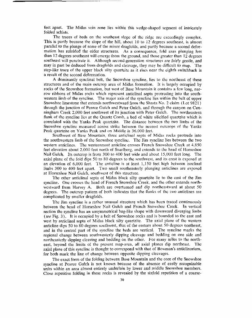
feet apart. The Midas vein zone lies within this wedge-shaped segment of intricately folded schists.
The traces of beds on the southeast slope of the ridge are exceedingly complex.
parallel to the plunge of some of the minor dragfolds, and partly because a second defor- This is partly because the slope of the hill, about 10 to 12 degrees southeast, is almost
mation has refolded the older structures. As a consequence, fold axes plunging less
southeast will penetrate it. Although second-generation structures are fairly gentle, and than 12 degrees southeast will emerge from the ground, and those greater than 12 degrees
may in part be deduced from dragfolds and cleavage, they may be ditlicult to map. The step-like trace of the upper black silty quartzite as it rises near the eighth switchback is a result of the second deformation.
A dominantly synclinal belt, the Snowshoe syncline, lies to the northeast of these
rocks of the Snowshoe formation, hut west of Base Mountain it contains a few long, nar- structures and of the main outcrop area of Midas formation. I t is largely occupied by
row ribbons of Midas rocks which represent anticlinal septa protruding into the south- western limb of the syncline. The major axis of the syncline lies within the belt of upper Snowshoe limestone that extends northwestward from the Shasta No. 2 claim (Lot 9821) through the junction of Pearce Gulch and Peter Gulch, and through the canyon on Cun- ningham Creek 2,000 feet southwest of its junction with Peter Gulch. The northeastern flank of the syncline lies at the Quartz Comb, a bed of white silicified quartzite which is correlated with the Yanks Peak quartzite. The distance between the two limbs of the Snowshoe syncline measured across strike between the nearest outcrops of the Yanks Peak quartzite on Yanks Peak and on Middle is 36,000 feet.
Southwest of Base Mountain, three anticlinal septa of Midas rocks protrude into the southwestern limb of the Snowshoe syncline. The Jim syncline lies between the two
feet elevation about 2,000 feet north of Snarlberg, and extends to the head of Horseshoe western anticlines. The westernmost anticline crosses French Snowshoe Creek at 4,850
Nail Gulch. Its outcrop i s from 300 to 400 feet wide and about 15,000 feet long. The axial plane of the fold dips 50 to SO degrees to the southwest, and its crest is exposed at
limbs 300 to 400 feet apart. Two small southeasterly plunging anticlines are exposed an elevation of 6,000 feet. The anticline is at least 1,150 feet high between isoclinal
at Horseshoe Nail Gulch, southwest of this structure. The other anticlinal septa of Midas black silty quartzite lie to the east of the Jim
westward from Harvey A. Both are overturned and dip northeastward at about SO syncline. One crosses the head of French Snowshoe Creek, and the other extends north-
complicated by smaller dragfolds. degrees. The outcrop pattern of both indicates that the flanks of the two anticlines are
The Jim syncline is a rather unusual structure which has been traced continuously between the head of Horseshoe Nail Gulch and French Snowshoe Creek. In vertical section the syncline has an unsymmetrical bag-like shape with downward diverging limbs
west by anticlinal septa of Midas black silty quartzite. The axial plane of the western (see Fig. 3 ) . It is occupied by a belt of Snowshoe rocks and is hounded to the east and
anticline dips 50 to 80 degrees southwest, that of the eastern about 50 degrees northeast,
regional change between southwesterly dipping cleavage and bedding on one side and and in the central part of the syncline the beds are vertical. The synclinz marks the
northeasterly dipping cleaving and bedding on the other. For many miles to the north- east, beyond the limits of the present map-area, all axial planes dip northeast. The axid plane of this syncline is thought to correspond with that of Bowman’s anticlinorium, for both mark the line of change between opposite dipping cleavages.
The exact form of the folding between Base Mountain and the core of the Snowshoe syncline at Pearce Gulch is not known because of the absence of easily recognizable units within an area almost entirely underlain by lower and middle Snowshoe members. Close repetitive folding in these rocks is revealed by the sixfold repetition of a coarse-
30

grit bed on Base Mountain and by the repetition of chlorite schist in numerous bands along the road south of the bridge across Peter Gulch.
The axis of the Snowshoe syncline lies within the outcrop belt of the upper Snow-
through the junction of Pearce Gulch and Peter Gulch to the canyon on Cunningham shoe member which extends northwestward from the Shasta No. 2 claim (Lot 9821)
Creek about 2,000 feet upstream from the junction of Peter Gulch. On the ljhasta claims close isoclinal folding is indicated by the numerous long outcrops of upper Snowshoe limestone. This limestone on Peter Gulch and Cunningham Creek is dragfolded and considerably thickened, and appears to be in the axial zone of the major fold (,we Plate V (B)) .
middle Snowshoe members are repeated, but not to the same extent that they are on the The northeastern limb of the Snowshoe syncline is overturned. On it the lower and
other limb. There is much close repetitive folding, particularly in the upper part of the Midas, disclosed by the outcrop pattern of the upper Midas limestone. This member outcrops in numerous long hands across a width of 4,000 feet northeast cd the Bralco
thick outcrops along Copper Creek. North of the mapped area it forms numerous cabin. Although the limestone may be not more than 25 feet thick, it forrns numerous
parallel ribs crossing Cunningham Creek downstream from Palmer Bench. Neither the precise outline of the stmcture nor the number of the many individual fol(ls is known, hut the tightness and repetitive nature of the isoclinal folding is apparent from the outcrop pattern of this readily recognizable limestone.
The Cunningham anticline lies on the northeast side of the Quartz Comb where Yanks Peak quartzite reappears at the surface on the northeastern side of the Snowshoe syncline. The core of the anticline is occupied by the Cunningham limeistone, which forms a continuous wide band extending northwestward from Sixbee Creek. Axial planes of the folds dip to the northeast, and the folds in the limestone appear to he smoother and larger than the more acute ones in overlying formations. The thinly bedded upper part of the formation is intensely dragfolded on a small scale.
which outlines the folds so well on the southwestern limb, outcrops prominently along Little is known of the northeastern limb, other than that the Yanks Peak quartzite,
the ridge extending in both directions from Cunningham S. The distance from Yanks Peak quartzite on the limb at Cunningham S to the southwestern limb at the Quartz Comb is about 12,000 feet.
The mapping of the Yanks Peak quartzite and of the Yankee Belle-6unningham contact has enabled the shape of the southwestern limb of the anticline to he interpreted in reasonably complete detail. Several large northwesterly plunging dragfolds having an amplitude from crest to trough of about 2,000 feet and numerous very much smaller ones are shown in cross-sections A-A3 and D-Dl of Figure 3.
Description of Structural Cross-sections
Four cross-sections have been drawn to provide a graphical illustration of the fold structure. A single long section, A-AiL, completely crosses the area from Yanks Peak to Cunningham S. The three other sections on Figure 3 illustrate structural features along selected lines.
along the lines of section were re-examined in order to substantiate the structural All structural sections were drawn in the field, and, wherever possible, outcrops
interpretation. The accuracy of the sections ranges downward from the reasonably accurate section D-Dl and the northeastern end of section A-A3 between Middle and Cunningham S, where information is fairly complete; to the diagrammatic representation of the form of the folds in A-A2 southwest of Harvey A, in B-B', and in CC1, where many uncertainties are involved in projecting dips, strikes, and plunges for Inore than a few tens of feet. The central part of section A-A:' between Harvey A and hliddle is the most diagrammatic because of the scarcity of marker beds and the general lack of specific
31

knowledge in the central part of the area. It is only when the trace of a single bed is thoroughly known that the form of a fold can be interpreted with confidence. Sections drawn on the basis of a large amount of detailed information may be found, when checked in the field, to be considerably less complex than the structures they represent.
east from French Snowshoe Creek in the extreme southwest of the map-area to Harvey A Section A - A 3,"The line of section A-A3 extends in a direction of north 50 degrees
on Base Mountain, and on Sheet A of Figure 2 the section line is marked A-A'. There is a break in the line of section at Base Mountain. The continuation, marked A2-A3 on Sheet B of Figure 2, extends through Middle to Cunningham S in a direction of north 40 degrees east.
west end of the section. The overturned fold is outlined by the Yanks Peak quartzite The Yankee Belle anticline with its core of Yankee Belle formation is at the south-
and i s surrounded by an envelope of Midas rocks. There are large dragfolds on the limbs of the fold. The intricate internal structure of the Midas rocks on the northeast side of Yanks Peak is shown diagrammatically.
To the northeast, near French Snowshoe Creek, is the Jim syncline with its filling of Snowshoe rocks. It is flanked on the southwest by a single southwesterly dipping anticlinal septum of Midas rocks and on the northeast by two northeasterly dipping anticlinal septa of Midas. Exposures on and west of Base Mountain indicate that there are numerous dragfolds on the limbs of the two main anticlines. The main feature of
of upper Snowshoe limestone west of Pearce Gulch. the central part of the section is the axis of the Snowshoe syncline marked by the belt
on its southwestern limb are drawn with reasonable accuracy. The thinning and tearing The northeastern end of the section shows the Cunningham anticline. The folds
displayed. This anticline extends northward to Roundtop Mountain with minor changes apart of the Yanks Peak quartzite on the flanks of the anticline at Middle are well
in shape. To the northeast a second anticlinal dragfold is outlined by the trace of the contact
between the Yankee Belle and Cunningham formations. These folds plunge northwest- ward at 10 to 20 degrees, and the southwesterly projections of the folded outline of the Yanks Peak quartzite and the Yankee Belle-Cunningham contact lie at a considerable elevation above ground surface on the ridge east of Nolaka Creek.
Creek in a direction of north 66 degrees east. The eastern side of an anticline extending Section B-Bl.-The line of section B-B' follows the top of the ridge north of Luce
from the head of Aster Creek is at the southwestern end of the section, and in it the thin upper member of Midas black silty quartzite is repeated many times across a width of
minor synclinal belt before the upper Midas black silty quartzite reappears at the surface 900 feet. To the east, ankeritic quartzite and limestone are repeated several times in a
and is repeated several times in steep, tight, isoclinal folds. Farther east is the lopsided
into it. The section ends at an anticline of Midas black silty quartzite. Jim syncline, with a very thin anticlinal septum of Midas black silty quartzite protruding
Section C-C'.-The line of section C-C1 runs due east from Horseshoe Nail Gulch to the head of Cunningham Creek northeast of the Cornish Ledges. A southwesterly
westerly dipping and southeasterly plunging anticlinal septa. Farther east is an anticline dipping anticline lies at the western end of the section. East of it are two small south-
whose crest near Horseshoe Nail Gulch is at 6,000 feet elevation and which is continuous to French Snowshoe Creek at 4,850 feet elevation. On Horseshoe Nail Gulch the axial
Luce Creek it i s more or less vertical, and at the ridge northeast of Yanks Peak and on plane of the anticline dips northeast, whereas on section B-B' along the ridge north of
section A-A' it dips to the southwest. No other individual structure is known to be similarly twisted. Farther east is the northeasterly dipping Jim syncline, flanked on its eastern side by an anticlinal septum of Midas upper black silty quartzite.
direction of north 41 degrees east. The anticlinal dragfold delineated by the Yanks Peak Section D-D1.-The line of section D-D' passes through Roundtop Mountain in a
32

quartzite has essentially the same shape as on the northeastern end of section .4-A3. The
Peak quartzite are extremely closely folded on a small scale, yet at the same time they Yankee Belle rocks in the core of the anticline and immediately below the hood of Yanks
accommodate themselves to the over-all form imposed by the Yanks Peak quartzite.
FAULTS Faults are a relatively inconspicuous surface feature in the Yanks Pea:k-Roundtop
Mountain area, and on the ground one is impressed more by the schistosity and the fold structures of the rocks. Actually, faults are fairly numerous, hut most are found only as the result of detailed mapping. However, some faults shown on the ac(:ompanying geological map may he observed, and are naturally exposed on the steep north face of Yanks Peak (see Plate I1 ( A ) ) , in the Yanks Peak quartzite along the helt striking
mine workings. The other faults are inferred. through Roundtop Mountain and Middle, or are exposed by surface and underground
In detailed mapping where outcrops are none too plentiful, a very real difficulty may be encountered in determining whether an offset bed has been displaced by a fault or by a plunging dragfold whose median limb has been greatly stretched or completely pulled apart. In many instances, exposures are too scarce to resolve the problem.
Most faults observed have a northerly to northeasterly strike between ;about north 20 degrees west and north 5 5 degrees east, and have an easterly dip. They are char- acteristic members of a general group of predominantly normal faults that is present throughout the mining area of the Cariboo. On many faults the movemellt has been
plunge of the folds and compensating for the regional plunge. On others the: movement mainly a down dropping of the eastern block, thus flattening the over-all northwesterly
has been largely horizontal, as indicated on the walls of some fault planes by striations plunging at small angles either to the north or south. Elsewhere the directicln of move- ment is disclosed by steep northerly plunging dragfolds of small amplitude.
exposed on the headwall, and runs southward across the southeast ridge of Yanks Peak. The Jews Hollow fault lies on the east side of Jews Hollow, where it is prominently
It has been mapped for a length of about 2,000 feet and has produced a right-hand hori- zontal separation of the formation of about 250 feet along the fault plane.
is another northerly striking fault with a right-hand horizontal separation of about 30 feet. About 400 feet to the west of it, and also exposed in the headwall of Jews Hollow,
Imperial vein at the head of Little Snowshoe Creek, underground in the Intermediate and Northerly striking faults of unknown displacement are observed along the wall of the
Low levels of the Snowshoe mine, along the Saddle vein, and in open-cuts made by J. Sockett on the south side of the main bend of French Snowshoe Creek. These points are more or less in line, hut it is uncertain whether they represent a single continusms fault or
ground in the Jim adit, in the Midas adit, and in the Plateau d’Or open-cuts. A large a number of similarly striking faults. Other northerly striking faults are exposed under-
fault was crossed by the Yankee Belle adit (now inaccessible) about 700 from the portal. It is thought to belong to this group of northerly striking faults.
Three main faults, largely disclosed by the detailed mapping of the Yanks Peak
to the southeast of Roundtop Mountain. The southeasternmost of the three, the Simlock quartzite, and of the contact between thc Yankee Belle and Cunningham formations, lie
fault, is the largest fault in the area. It follows an exceedingly sharp notch hetween the heads of Nolaka and Simlock Creeks, striking about north 10 degrees east. The extension of this fault southward beyond the limits of the area may account for the o e e t of lime- stone beds along a depression northeast of the junction of Simlock and Harvey Creeks.
The movement on the Simlock fault, as judged by the displacement of the crest of an anticline of Yanks Peak quartzite, was almost wholly horizontal and resulte83. in a left- hand separation of about 800 feet along the fault plane. Numerous small flexures in the Midas beds near the fault confirm the direction of relative movement.
2 3 3

Two smaller faults in the cirque at the head of Nolaka Creek are probably branches of the main Simlock fault. One has an apparent left-hand separation of about 200 feet and the other a 50-foot right-hand separation. Beds visibly offset on opposite sides of two small creeks make these faults clearly evident, hut their continuations are uncertain because of lack of outcrops in the talus at the head of the cirque.
The Lostway fault is inferred between Middle and Roundtop Mountain because all
degrees, and the lack of reversal in plunge indicates that a fault has dropped the structures fold structures on Middle and Roundtop Mountain plunge northwestward at 10 to 20
to their known position on its southeast side. The Lostway fault is assumed to strike north 27 degrees east and to lie along the northwest side of the head of Lostway Creek. Additional evidence of faulting is the displacement of the limestone contact just north- west of Lostway Creek and of the diabase dyke in the saddle between Roundtop Mountain and Middle. The amount of throw* is estimated to be about 550 feet. The estimate is based on the relative displacement of the axis of an anticline outlined by Yanks Peak quartzite and on the assumption that the average plunge is 10 degrees northwestward. A second estimate of the throw, based on the displacement of the Yankee Belk-CuMing- ham contact, is about 300 feet downward on the southeast side of the fault. There was probably a small amount of right-hand horizontal movement as well.
The Coppzr Creek fault is inferred because of the offset of the Midas-Snowshoe con- tact below the bridges on Copper Creek and of the belt of upper Snowshoe rocks that lies south of the junction of Peter Gulch and Pearce Gulch. Surface trenches near the south- west corner of the Cutler No. 1 claim (Lot 10596) disclose northerly striking faults that are assumed to be strands of the larger Copper Creek fault. The fault has a hearing of north 1 3 degrees east and a total right-hand horizontal separation of about 600 feet along the fault plane.
The Roundtop fault is visible as a prominent lineament cutting across the southeast slope of Roundtop Mountain (see Plate VI11 (A) ) . It is occupied by an unsheared lamprophyre dyke. The fault has an average strike of north 55 degrees east and dips steeply southeast. Striations plunging 40 degrees eastward on a slickensided plane dip- ping X0 degrees southeast show the direction of the last fault movement. An estimate, based on the displacement of fold structures on opposite sides of the fault, indicates
moved down and to the northeast (left). a throw of about 350 feet and a heave? of about 700 feet, the southeast side having
Gouge or pulped rock, in layers several feet thick and conformable with the bedding, has been observed on the surface and in underground workings. These layers probably
of interbed slippage during shear folding. An example is the crush zone 200 feet west of formed by concentration of movement in certain soft beds, and may represent an extreme
but there is no evidence that they cross the bedding in the axial regions of the folds. the Saddle shaft. Alternatively, these gouge or crush zones might represent strike-faults,
are known in the area. No large strike-faults such as have been described$ in other parts of the Carihoo region
CLEAVAGE
in the area, with the exception of a few of the intrusive rocks and some of the more Flow cleavage of varying degrees of perfection is regionally d e v e q e d in all rocks
completely ankentized or silicified rocks. The cleavage ranges from widely spaced planes in thickly bedded coarse quartzite, through %- to 1-inch spacing in flaggy impure quartz- ite, to highly fissile slate and papery schist. The degree of fissility depends mainly on the amount of sericite that has been developed in the rock, and to a lesser extent the position of the rock in relation to the crest or limb of a fold.
* vertical component of dipslip. t Horizontal component Of dip-slip. f ~ d . sur"., Canado, Mem. 149, P . 36: Paper 38-16, PP. 13, 16.
34
of the fold (see Plate V ( B ) ) and is taken to he axial plane or flow cleavage. By exten- In all the smaller fold structures the cleavage is seen to be parallel to the axial planes
sion it is inferred that this regional cleavage is parallel to the axial planes of major folds. In most instances the cleavage is parallel to the bedding of the rocks. If it is also
parallel to the axial plane, it must be inferred that the folds are isoclinal. It i r ; only at and near the crests or keels of folds that bedding is seen crossing cleavage (see Plates V (A) and VI1 (B)). The angular relationships between bedding and flow cleava~,e were used for structural interpretations.
the axial region of a fold where it is parallel to the bedding and obviously not parallel to In a few instances a bedding cleavage* as distinguished from flow cleavage is seen in
the axial plane. One of the difficulties in mapping complex structures in detail is that axas of poor
conditions, rocks in the axial region are more broken than those on the limb!; and conse- outcrop contain too little information in the axial regions of the folds. Under uniform
zone is the presence of the rod-like fragments which result from the rock breaking along quently are less capable of outcropping. One valuable clue to the location of an axial
both cleavage and bedding planes when they are almost at right angles to each other. Where no outcrops are present, one may safely infer the near-by presence of an axial zone when a rubble of pencil-shaped or rod-like pieces is seen.
a second, younger period of deformation. This folding has been accompanied by slippage In places the well-developed flow cleavage or schistosity bas been folded during
along the planes of foliation rather than along the planes of the original betiding. The younger folding is fairly gentle and open, hut is nevertheless accompanied by its own flow
older cleavage at various angles. cleavage, which is parallel to the axial planes of the secondary folds, and cuts across the
eastern side of the Jim syncline (see Plate VI (A)). The cleavage planes normally are Fracture cleavage cutting across the flow cleavage is widespread in a belt on the
spaced 1 to 2 inches apart. West of the axis of the Jim syncline the fracture cleavage dips 10 to 30 degrees southwestward, and east of the axis of the Jim syncline t i e fracture
planes, between the crosscutting planes of fracture cleavage, are bent into eit:ier normal cleavage dips 15 to 30 dcgrees northeastward. In some instances the o1dt:r cleavage
movement along the fracture cleavage surfaces. Too few observations were made to or reversed sigmoid curves (see Plate VI ( B ) ) , indicating that there has been slight
establish a pattern of direction for this movement.
JOINTS AND FRACTURES
Almost all the rocks in the area are intersected by joints. The joint-planes are vertical or dip steeply, mainly to the southeast. and the strike of almost all of them lies between north 40 and north 85 degrees east; most of them strike north 45 to '70 degrees east. In most instances the strike of a joint-plane is within a few degrees of being at right angles to the strike of the schistosity of the enclosing rock, and the dip is almost at right angles to the plunge of the fold structures. Most variations in strike of the rocks are accompanied by a change in the orientation of the joints. Joints of the group that are essentially at right angles io the plunge of the fold structures are believed to be extension (ac) joints that were formed during the initial folding.
which may have originated as a joint. The strike of associated tension fractures is either In some instances, movement has taken place along a northeasterly strikir:g fracture
easterly or northerly, depending on whether right- or left-hand movement was involved (see Fig. 5 ) .
65 degrees east. Several of these veins show evidence of movement along their walls, and Some quartz veins occupy fractures striking between north 80 degrees east and south
it is evident they occupy subordinate shears. Other veins occupying fractures striking M. P. Billings, ' ' S t m ~ f ~ r a l Geolok/," Prenrieo Hail, 194X p. 218.
35
R l g h t hand m o v e m e n t ' I L e f t h a n d m o v e m e n t
1 I o m p l o m o n t o r y s h e a r s a n d o r r o c i o t e d d i r e c t i o n o f t e n s i o n
Figure 5 . Diagram showing tension fractures in relation to direction of fault movement, and also complementary shears and their associated direction of tension.
north 40 to 60 degrees east are commonly associated with them (see Fig. 5). Comhina- tions of these two fracture directions are associated with northerly striking normal faults with right-hand displacements. It is believed that the easterly striking fractures and the northerly striking faults represent complementary shears. Normally the associated tension would be released by the formation of a set of northeasterly striking fractures, but because northeasterly striking extension joints already existed it is believed that the associated tension merely reopened pre-existing extension joints. Furthermore, any northeasterly striking fractures, especially those originally formed in tension, would be reopened by a continuation of right-hand movement along a northerly striking fault.
LINEATION Linear structures are developed in the rocks in the area, and almost without exception
the lineation strikes in a northwesterly direction and plunges either northwest or southeast, parallel to the regional plunge.
The features most commonly seen are dragfolds with amplitudes of a few inches to a few feet, and pencil- or rod-like fragments produced by breaking along cleavage and bedding planes more or less at right angles. Under favourable circumstances the trace of bedding on axial-plane cleavage may be observed in the axial zone of a fold; the plunge of the trace conforms with the regional plunge. The cleavage planes of argillaceous schists of the Midas formation commonly are crinkled in chevron-like folds ranging down from an amplitude of about 1 inch to a crepe-like puckering.
The pebbles in the basal Snowshoe conglomerate have been only slightly elongated and now possess the general proportions of pumpkin seeds. They are flattened in the plane of foliation, and their longest axis lies parallel to the structural plunge.
36

AGE OF STRUCTURAL FEATURES
The age of structural features cannot be determined from 0bservatio:w within the area but must be based upon regional information. The complex early f'olding of the
gently folded, nor the Jurassic Quesnel River group, which locally may be sharply folded. Cariboo group does not involve the Mississippian Slide Mountain group, which is more
The age of the early folding, therefore, must be pre-Mississippian. If the Lower Cambrian formations lie conformably* above rocks of the Cariboo group in the Little River area, then the early deformation must be post-Lower Cambrian in age.
Cariboo group by later deformation. The fact that Jurassic rocks are deformed indicates Open folds and other secondary structural features were developed in rocks of the
that some deformation was post-Jurassic. However, the suggestion that the intensity of the folding in the Slide Mountain and Quesnel River groups may be differmt raises the possibility that some of the deformation may be post-Mississippian and pre-Triassic? in
cannot be distinguished. age. Two ages of post-Mississippian secondary structures in the Carihoo group rocks
The precise age of the faulting is not known. The northerly and :northeasterly striking faults cut the Cariboo group and all fold structures within those rocks. They are
lated with the Mount Murray intrusions of uncertain age, in the Yanks Peak-Roundtop known to cut the Slide Mountain group in the Antler areat and cut diabase $dykes, corre-
Mountain area. They must be post-Mississippian in age, and even though they are not definitely known to cut the Quesnel River group. the fact that the faults th8:mselves are not deformed suggests that they are post-Jurassic in age.
* Geol. Sur"., Canada, Paper 38-16. p. 13. t Evidence i s piesenled in Geol. S~rv.,'Conndn, Mem. ZSZ, 1949, PP. 42. 43, 121, that Suggests pte-unper Triassic
deformation in the For1 St. James area.
37

CHAPTER 1V.-ECONOMIC GEOLOGY
INTRODUCTION
Roundtop Mountain area. The importance of the area, if judged solely upon the value Gold has always been the metal of chief interest to miners in the Yanks Peak-
of gold produced, may not appear very great in view of the total recorded lode-gold production* of only 5,204 fine ounces. Furthermore, the amount of placer gold recov- cred, although not accurately known, is estimated to be small and may he little greater
placer creeks-namely, Keithley, Harvey, and Cunningham Creeks-and contains the than the amount of lode gold. Nevertheless, the area lies at the heads of three important
outcrops of numerous gold-hearing quartz veins.
on the lower part of Little Snowshoe Creek indicates that a locus of gold mineralization The presence of gold-bearing veins at the head of Luce Creek and of rich placers
lies near Yanks Peak. Work was initiated there in continuation of a study of the placer- and lode-gold occurrences of the Cariboo, a study that was begun in the vicinity of Stanleyt. Near Yanks Peak it was known that reasonably numerous outcrops were present. Moreover, it was hoped that an understanding of the structural environment of the veins might be useful in guiding further exploration, not only within the area itself, but in other parts of the Cariboo.
stratigraphic and structural ideas regarding Cariboo geology needed revision, and, as As the work progressed, it became increasingly apparent that practically all former
a consequence, the mapping was extended beyond the original Yanks Peak area to
further extended by A. Sutherland Brown from Roundtop Mountain to the vicinity of include the Cariboo Hudson mine and Roundtop Mountain. The mapping has been
the mines at Wells. A considerable amount of time was devoted to working out some of the complex folds, because elsewhere in the Cariboo folds have been extremely important in localizing replacement mineralization and in controlling the position of certain rocks whose response to fracturing has made them more susceptible to vein mineralization. Some of the vagaries of vein occurrence, such as their non-persistence along strike or at depth, may be explained by changes in host rock resulting from intricate folding. It is hoped that the present interpretation of fold structures in the Yanks Peak-Roundtop Mountain area will provide basic ideas applicable to prospecting and exploration throughout a far larger area in the Cariboo.
EARLY HISTORY OF LODE-MINING
Many of the early placer-miners were familiar with lode deposits and were inter- ested in their discovery, and from time to time discoveries were made. Although only
some important quartz veins were found. However, none of the outcropping veins was a small amount of lode prospecting was done at the time of the early placer activity,
awaited better transportation facilities and the higher price of gold that has prevailed rich enough to he worked profitably by arrastre, and extensive development of the veins
since 1932.
bank of Little Snowshoe Creek (the identity of this vein is not known). A few months In December, 1862, three claims were recorded* on a quartz vein on the right
later, in April, 1863, Thomas Haywood, Edward Jeffrey, and eleven others, calling
of the creek now called Luce Creek. The Douglas vein is on the Old Timer claim (Lot themselves the Douglas Company, recorded claims on the Douglas veins at the head
property during the summer of 1949, and h s m d l production irom the Rand. The amount of gold recovered by *Largely from the Carihoo Hudson mine. hut including t h e production from a small mill operated on the Midar
arra~tre from the Haywood vein is not known but could not have becn very large. t B.C. Dem ol Miner. Buil. No. 26, 194R. f Recorded by L. D. Loucks, P. 0. Coole, and C. T. Seymour. 5 The Douglas vein was later h o w " as the Haywood yein or the Arraslre vein.
38

and Jeffrey had written the Colonial Secretary on October 25th, 1862, announcing their 11337),* and the Lower Arrastre adit shown on Figure 13 is driven on i t . Haywood
discovery of the vein and requesting discovery privileges. Their request was responsible for the enactment of the first regulations concerning simple partnerships for mines. The discovery of the Douglas vein led to a rush of quartz-claim stakings on Little Snow-
recorded a claim in May, 1863. shoe Creek in the early spring of 1863. William Luce’s name first appc:ars when he
In June, 1863, H. W. Steele and seventeen others, calling themselves the Monte Christ0 Company, recorded eighteen quartz claimsf on French Snowshoe Creek, run- ning 900 feet up each side of the valley from the creek and said by them to be about
and Cunningham tunnel which is shown on Bowman’s map of Little Snowshoe and 1% miles downstream from the upper forks. This company probably drove the Steele
Keithley Creeks, but whose precise position on the ground is unknown. In August, 1864, Thomas Haywood, G. W. Anderson, William Luce, and eight
others, known as the Rising Sun Company, recorded eleven claims on a quartz vein on
showings, but it may be on what are now known as the Talbot and Corban showings). Little Snowshoe Mountaini (the above location is not positively identified with present
In July, 1869, A. Johnson, B. Gallagher, and Rees Davies recorded three discovery
is now known either as the Hebson vein or the Imperial vein. quartz claims on a north fork of Little Snowshoe Creck. These may have been on what
ledge on Snowshoe now being prospected by Mr. Thos. Haywood was made last week The Cariboo Sentinels of August 28th, 1875, reports “ an assay of qllartz from a
at the Government Assay Office. The result, 7 02. silver and 2 oz. gold to the ton.
identified with any known today; it may be either a vein near the old Douglas vein or The Ledge is well defined and has only been sunk on a few feet. [This vein is not
some vein near the Holmes Ledge.] Mr. Holmes is also sinking on a ledge in the same neighbourhood and is down about 30 feet.”
In September, 1875, William Holmes recorded a claim on a quartz vein (the Holmes Ledge) on a small creek emptying into Swift River between Six Mile Creek and McMartin Creek. The next year Thomas Haywood recorded a claim adjoining the one belonging to Holmes. The Cariboo Sentinel of September 25th, 1875, reports that an
a content of 14 02. 17 dwt. I1 gr. silver, and 19 dwt. gold per ton. assay made by the Government Assay Office of a sample from the Holmes Ledge revealed
In 1886 Veith and Borland relocated the old Haywood vein (Douglas vein), cleaned out the old adit, and shipped out some vein quartz for a test. Additional work was done the next year, but thereafter nothing appears to have bcen done for many :fears. The claims lapsed, and the ground was relocated by R. Reinhold in 1928. It WIN Reinhold
Snowshoe Gold Mines Limited in 1937. and his partners who optioned the group of claims to Fred Wells when he organized
No records of quartz locations on Cunningham Creek are available before Bow- man’s visit to the creek in 1885. At that time he sampled the Quartz Comb near Round- top Mountain and also several veins exposed by placer operations at Sharp’s Bench and
claims were located in 1922. The showings on these claims, and other show..ngs farther farther downstream.1) No further lode activity is noted until the original Cariboo Hudson
down Peter Gulch, received only intermittent attention until the early 1930’s, when interest in gold prospects in the area revived with the advance in the price of gold.
properties described in Chapter VI, page 57. Lode activities since the early 1930’s are recorded individually under the various
* T h e lot numbers of all SurveYed clsims are listed numerically in Appendix A, Dp. 90, 91 t Qiartz claims at that time were 100 feel s4uare. $Yanks Peak was known to oldtimers as Little Snowshoe Mountain. 5 T h c Cariboo Sentincl WRS puhiished in Barkerviiie from 1865 to 1R75. I1 Geol. Surv., Conodo. Ann. Rept., 1887-88, Vol. 111, Pt. I, PP. 4% 44c.
39

GENERAL CHARACTERISTICS OF THE QUARTZ VEINS
The numerous quartz veins in the Yanks Peak-Roundtop Mountain area vary greatly in size, ranging in width from a few inches to tens of feet, and in length from a few tens
the basis of their general strike into three main classes-northerly striking, northeasterly of feet to more than a thousand feet. Regardless of their size, they may he grouped on
to the strike of the rocks and either dip with the bedding or cut across it, are rare. striking, and easterly striking. Northwesterly striking veins, that are generally parallel
degrees west and north 10 degrees east and dip steeply eastward. All the large veins in The northerly striking veins occupy faults or shears which strike between north 10
the area belong to this group. The longest is the Hebson vein, whose length is about
main veins belonging to this group are the Hudson, Hebson, Imperial, Snowshoe, Pauline, 1,600 feet, and the widest is the Imperial, whose greatest width is about 40 feet. The
Betty, Lipsey, and Saddle veins. The northeasterly striking veins occupy tension fractures striking between north
40 degrees east and north 80 degrees east and for the most part dipping steeply south-
direction. These veins generally are from a few inches to a foot or more wide and are eastward. Only in rare instances has there been movement along fractures of this
instances they are associated with a northerly striking fault having right-hand movement, seldom more than 100 feet long. Veins of this group generally occur in swarms. In most
northeasterly veins is more or less at right angles to the strike of the formation and to the or with a northerly striking vein which occupies a shear or fault. The strike of these
plunge of the fold structures. Consequently, variations in strike of the formation are reflected by changes in strike of the veins. Veins of this group are seen on the surface and underground on the Snowshoe, Jim, and Midas properties, and on the surface at the Corban showings and the Stockwork.
south 7 5 degrees east. In some instances there is shearing along the walls of the vein. The easterly striking veins occupy fractures striking from north 80 degrees east to
These easterly striking veins are narrow, from 1 to 3 feet in width, and in general are slightly longer than the northeasterly striking ones. Veins of this group may be seen on the surface and underground on the Jim and the Midas properties.
In some instances, veins do not occupy single fractures but form along two directions of fracturing, of which one or the other may dominate (see Fig. 6). The branching pattern thus produced is illustrated on the Camp and Intermediate levels of the Snowshoe mine by the main vein which has formed along a northerly striking fault and from which small strands branch off along northeasterly fractures; on the surface at the Jim mine by veins occupying both northeasterly and easterly striking fractures with either direction dominating; and in the Midas adit by veins occupying both northeasterly and easterly fractures, of which the easterly direction dominates.
strike at a small angle. They strike north 55 degrees west, dip stecply to the northeast, The Cornish Ledges are northwesterly striking veins which cross the formational
and presumably occupy tension fractures. The veins reach 2 feet in width and have a maximum observed length of 125 feet.
The Plateau d’Or vein and a vein lying east of the Cornish Ledges are northwesterly striking veins that are parallel to the strike of the beds. They dip steeply northeastward, cut across the dip of both bedding and cleavage, and presumably occupy small strike- faults. These veins in local enlargements may swell to a width of 10 feet or more and are 250 feet and 400 feet long respectively.
VEIN MINERALIZATION
appearance. Small crystal-lined vugs occur in most vein quartz. At the Corban showings The vein quartz is generally massive or only slightly fractured and has a milky-white
the vugs are exceptionally large and may be lined with quartz crystals 1 to 2 inches across. 40

C A R 1 0 0 0 H U D S O N MINE
200 L e v e l South ',.. '4
3y 9,.
0 u 2 0
SNOWSHOE M I N E
CarnpLovrl
4 0 0-
J I M O U T C R O P S
M I D A S C R O S S C U T THE S T O C K W O R K
SNOWSHOE M I N E
L o w e s t L e v e l
Figure 6. Patterns of branching veins shown in relation to the major directions of fracturing. ~~ ~ ~~ ~~
Ankerite is an extremely common but not universal gangue mineral w:iich for the most part appears as a selvage a quarter of an inch to an inch wide along thc vein walls, or as disseminated grains within the vein. In some instances, narrow veinlets of ankerite extend from quartz veins into the wallrock. The variability in composition of the ankerite is shown by the chemical analyses in Appendix B (see p. 92). I t is considered that the ankerite-bearing veins have been the source of at least part of the widespread ankerite in the country rocks (see p. 24).
content of any vein rarely being more than 1 or 2 per cent. Pyrite is the most abundant With few exceptions, the quartz is extremely sparsely mineralized, the sulphide
of the vein sulphides and occurs in irregular masses and disseminated grains. In addition,
French Snowshoe Creek are pyritized. Assays indicate that the quantity of gold is closely some of the wallrock in the Yankee Belle adit and some of the rocks in the canyon on
related to the amount of pyrite in a vein and that, where visible gold is not present, the highest assays are obtained from samples containing the most pyrite.
have been such that the quartz may be completely free of iron stain. In other veins Commonly the pyrite is leached from vein outcrops, and conditions of weathering
41
abundant limonitic residues and stains are present. Close observation should enable one to distinguish between the reddish-brown colour and rhombic cavities resulting from the weathering of ankerite and the yellow-brown colour and cubic forms derived from pyrite.
Galena and sphalerite may he present in the veins. Generally they are in small amounts as disseminated grains, although locally, as at the Carihoo Hudson and on the Sedan and Hibernian claims, small concentrations of galena and sphalerite may occur.
A vein discovered in 1951 on the Skam claim north of the Copper Creek bridges is well mineralized with tetrahedrite. This mineral is commonly present in veins along Copper Creek but has not been observed elsewhere.
Scheelite is present in small amounts in many of the quartz veins, but significant amounts are present only at the Taylor Tungsten, in a vein near Snarlberg, at the Cariboo Hudson, and near the bridges across Copper Creek. Tungstite formed by alteration of scheelite occurs in small amounts at the Taylor Tungsten showing.
Visible gold is present in the outcrops of some veins, mostly as small rough pieces and flakes lodged in the cubical cavities from which pyrite grains have been leached. Some gold, particularly in the Lipsey and Saddle veins, is in unfractured and otherwise unmineralized quartz, hut it is estimated that the amount of such free gold is small. Assays indicate that most gold is associated with pyrite. It only becomes visible when the pyrite is leached. As a consequence, little or no gold is visible in veins exposed in
outcrops. underground workings, whereas some was seen or has been reported from most vein
ORIGIN OF THE VEIN FRACTURES
Either they occupy the main fault or the fractures of two directions which may accompany The veins for the most part are closely associated with northerly striking faults.
it. The northerly striking faults are the dominant faults of the area, and fractures of two other directions were formed at the same time. Those fracturcs striking eastward are parallel to the complementary direction of shcar (see Figs. 5 and 6 and p. 35), and those striking northeastward are essentially parallel to the associated direction of tension.
has been post-mineral movement. It has not been possible to determine the total The northerly striking veins occupy faults along which, in some instances, there
displacement along the various faults, but some represent a considerable amount of movement. These northerly striking faults are comparable to ones of similar attitude which occur in all parts of the Carihoo and represent the last main structural event following the several periods of folding. No doubt both the mineralized and unmin- eralized faults were formed during the same structural episode. Their widespread distribution links them with regional structures, of which no further information is available within the area.
The northeasterly striking veins occupy tension fractures along which there has been no lateral movement. The fractures are almost at right angles to the elongation of the rock and are believed to have originated as extension ( ( I C ) joints (see p. 35). Later, right-hand movement along near-by northerly striking faults subjected the northeasterly fractures to tensional forces which tended to reopen them (see Fig. 5). In a few instances, zones of northeasterly veins are not known to be associated with any faults. Evidently such fractures were reopened by stresses that were not accompanied by fault movements.
The easterly striking veins are contemporaneous with those of the other two directions and are believed to occupy fractures formed by subordinate shearing stresses associated with the northerly striking faults. Right-hand movement along a northerly fault should he accompanied by left-hand movement along complementary easterly shears (see Fig. 5) . All observations do not fully conform with this relationship because there appears to have been post-mineral movement along some easterly striking veins. The direction of this last movement is not constant, nor is it certain that it has been in the same direction as the pre-vein movement.
42
The Plateau d’Or vein and the vein east of the Cornish Ledges are two northwesterly striking veins, parallel to the strike of the rocks, that are believed to occupy strike-faults. There has been some post-mineral movenlent along the vein walls, but no indication was seen of the total amount of displacement along the faults. The Corniilh Ledges are northwesterly veins occupying fractures which cut across the formation. They are regarded as tension fractures, inasmuch as there is no evidence of movemerlt along them. The veins are in the lower Snowshoe quartzite immediately overlying the crest of a small anticline of Midas black silty quartzite which lies on the west side of a larger anticline
The fractures could have been formed by left-hand movement parallel to the beds or along of the same rock. Both the structural setting and the direction of fracturing are unique.
a northerly striking fault, but no evidence of either was observed.
DISTRIBUTION OF QUARTZ VEINS
The position of northerly striking faults is the most important factor, becauiie most veins The chief factors inRuencing the distribution of quartz veins have helm structural.
either occupy such faults or occupy fractures that are directly related to them. Factors
particular rocks in a structural setting may affect the nature and extent of the fracturing. of lithology or rock type are important only in so far as the relative competencies of
Folding controls the distribution of rocks that locally may be favourable tc vein forma- tion, but the veins seem to bear no significant geometric relationship to a:ny particular
Quartz veins occur in the rocks of most of the formations, but they are more numer-
although it was not studied as extensively as the other formations, appears to contain very ous in the Midas and Snowshoe formations than in others. The Cunningham limestone,
few veins. The Yankee Belle formation near Yanks Peak contains the Corban and Talbot showings but near Roundtop Mountain is not known to contain any mineralized veins. The only known mineralized veins in the Yanks Peak quartzite are those at Sockett’s showing on French Snowshoe Creek. In contrast, many veins are known in rocks of the Midas and Snowshoe formations.
the northeasterly and easterly veins at the Midas mine, and the northerly and northeasterly Near Yanks Peak, Midas argillaceous schist contains the Lipsey and Saddle veins,
striking veins at the Snowshoe mine. The Midas black silty quartzite contains the Hebson, Imperial, Plateau #Or, Pauline, and Betty veins, all of which are northerly striking, yet that member is not known to contain any northeasterly veins. Near Round- top Mountain the only known mineralized veins in the Midas formation are the tungsten showings on the Skarn claim and the zinc replacement mineralization near the Bralco cabin.
Snowshoe rocks, there being a general absence of veins in the Midas rocks. In contrast, Near Roundtop Mountain the veins are dominantly northerly striking and are in
many northerly striking veins as well as numerous northeasterly and easterly striking veins occur in both Midas and Snowshoe formations near Yanks Peak.
veins, the Taylor Tungsten showing, the Cariboo Hudson vein, numerous veins along The Snowshoe formation contains the Stockwork, the Cornish Ledgl:s, the Jim
Peter Gulch and Cunningham Creek, and numerous unmineralized quartz veins on the Snowshoe Plateau. No veins have been seen in the Snowshoe basal conglomerate.
Hebson, Imperial, Snowshoe, Lipsey, and Saddle veins. The veins which actually occupy faults are the northerly striking Cariboo Hudson,
faults and all are more or less in line. Their alignment suggests that they lie along The four veins at the Imperial, Snowshoe, Midas, and Sockett workings all occupy
a single continuous fault, but there is no other evidence of one.
numerous northeasterly veins on the Snowshoe property, the Jim veins, and .the C a b a n Veins which probably are associated with near-by northerly striking faults are the
veins. 43
fold.
The position of veins in relation to the fold structures of the enclosing rocks is neither uniform nor particularly significant. The Cornish Ledges lie at the apex of a small anticline. The Hebson and Imperial veins are in anticlinal septa. The Snowshoe veins
that the Hebson vein occupies. The Corban veins are in an anticlinal rcgion. The Jim are in a minor anticlinal zone which may be a southeasterly extension of the same anticline
panel. The Cariboo Hudson and other veins along Peter Gulch lie along the east side of showings and the Stockwork lie in a synclinal zone, and the Midas veins are in a flanking
the Snowshoe syncline.
of an anticlinorium lying east of the Peak is without foundation, since it has been demon- The old concept that veins near Yanks Peak are in some way related to the axis
strated that no such structure exists. The veins are not related to the axis of the Yankee Belle anticline which lies just west of Yanks Peak, nor to any other fold structure.
Roundtop Mountain lay within the middle Hudson member.* This simple stratigraphic Formerly it was considered that the majority of auriferous veins in the vicinity of
relationship is no longer valid because the middle Hudson quartzite is now known to be part of the lower and middle Snowshoe members, which are far more widespread than are the known veins.
The main conclusions drawn from the distribution of veins arc that:- (a) Veins are localized mainly by structural rather than stratigraphic factors. ( b ) Most veins occur along or are associated with northerly striking faults. (c) Fold structures localize veins only in so far as they influence the position
of a bed that fractured more readily.
AGE OF GOLD MINERALIZATION
The contemporaneity of formation of northerly, northeasterly, and easterly veins is evident from the relationships of northerly and northeasterly veins in the underground workings of the Snowshoe mine (see Fig. 6 and p. 82), and of northeasterly and easterly veins in surface workings on the Jim and in underground workings in the Midas adit.
essentially contemporaneous and was later than the initiation of movement along the The introduction of vein quartz into all three sets of vein fractures must have been
northerly striking faults.
it is considered to be post-Jurassic in age. The age, therefore, of the quartz and gold The precise age of the faulting is not known, hut for reasons set forth on page 37
mineralization, which occupies fractures related to the major faults, cannot be pre- Mississippian but must be post-Jurassic.
River group of Jurassic age establishes the existence of a post-Jurassic gold-bearing The fact that elsewhere in the Cariboo auriferous quartz veins occur in the Quesnel
mineralization. This evidence supports the belief that the quartz veins of the Yanks Peak-Roundtop Mountain area are post-Jurassic.
DISTRIBUTION OF GOLD
Within the veins themselves visible gold is seen in and around pyrite, or in cavities or cracks surrounding pockets from which pyrite has been leached. All assays indicate
high gold assays are invariably obtained from samples containing a large proportion of that gold is associated with pyrite rather than with the other vein minerals. Although
pyrite, the gold-pyrite ratio is not constant. Visible gold not associated with pyrite or other sulphides was seen only in the Lipsey and Saddle veins.
There is no satisfactory explanation for the variability of the gold-pyrite ratio, nor for the fact that some veins are mineralized with pyrite and others near by are not.
The prevalence of visible gold in the vein outcrops and its absence from veins in underground workings seems to be directly related to the leaching of the pyrite which
proof of a secondary origin of the visible gold. allows the gold to be seen. Although some evidence might he so construed, there is no
* ~ e o l . Surv., Conado, Paper 38-16. P. 18. 44
Two main areas containing gold-hearing veins are indicated by the occurrence of auriferous veins near Yanks Peak in Midas rocks at the very head of Luce Creek, and near Roundtop Mountain in a band of lower and middle Snowshoe quartzites along the northeast side of the axial zone of the Snowshoe syncline. Erosion of vein!; in these two areas undoubtedly supplied gold that was concentrated in local placers a\: the head of Luce Creek and on Pearce Gulch and Peter Gulch.
Snowshoe Creek, and on Cunningham Creek downstream from the head of Palmer Bench The main concentrations of placer gold on Keithley Creek, the lower part of Little
are not believed to have heen derived from veins in the two known areas of vein outcrop. The distribution of gold in these three placers is interpreted as meaning that other areas are, or have been, underlain by gold-hearing veins. The Keithley Creek placer gold is thought to have had a bedrock source other than the known gold-beariug veins near Yanks Peak (see p. 56). Part of the placer on lower Little Snowshoe Crttek may have heen derived from veins at the head of the creek, hut a large part is believed to have had its bedrock origin in veins closer to the placers (see p. 5 5 ) . Small placer accumulations were worked on Pearce Gulch and on Peter Gulch downstream from the mouth of Crazy Cr-eek, but the bulk of the placer gold mined from Cunningham Creek wa!; downstream from the head of Palmer Bench. This main placer probably had its bedrock source closer than the known veins along Peter and Pearce Gulches. The known veins probably contributed gold to the two small placer accumulations in the gulches.
FINENESS AND SPECTROCHEMICAL ANALYSES OF GOLDS
When work was first started around Yanks Peak, samples of gold were obtained wherever possible from the outcrops of the various veins and from placer occurrences. The fineness of the gold in those samples was determined, and a spectrochemical analysis was made. It was hoped that some general relationships might be establixhed between lode golds from different veins, and between lode gold and placer gold derived from the same bedrock source. The investigation was not completed because of difficulties in
preliminary work. The fineness results are tabulated in Appendix C and Appendix D obtaining sufficient suitable gold samples, and also because of the erratic results from the
(see pp. 93-97). Sufficient weight of sample to ensure a reasonable accuracy for the fineness determinations and to provide a sample for spectrochemical analysic; was difficult
ing and is indicated in some instances. to obtain. The precision of the fineness values is dependent upon the accuracy of weigh-
On the Snowshoe property the fineness of gold from two surface exposures is 900 and 906, with an extreme range of from 879 to 920. The average fineness of gold from veins exposed underground, determined on gold beads obtained by smelting pyrite, is 915, with a range of from YO2 to 933.
The fineness determinations on the Jim claim are on golds obtained lrom a single open-cut. The average fineness is 867 and the range is from 861 to 879.
The fineness of golds from four veins on the Midas property lies within a snlall bracket of variation. Gold from the Saddle vein averages X78 fine and ranges from 875 to 880; from the Tait vein, averages 884 fine and ranges from 868 to 8511; from the Station 4 vein, averages 88s fine and ranges from 886 to 889; and from the Lipsey vein, averages 895 fine and ranges from 881 to 908.
and 887. Gold from the Corhan vein averages 864 fine from two determinations of 841
from 820 to 858. Gold from Keithley Creek averages 913 fine and ranges from 869 to Placer gold from French Snowshoe Creek has an average fineness of 834 and ranges
941. One fineness determination of gold from Little Snowshoe Creek is 888 and one of gold from Luce Creek is 818.
from different veins are not apparent from information available in the area. No explana- Reasons for significant differences in fineness of lode golds from the !;arne vein 01
45

tion is apparent for the low fineness of placer gold from French Snowshoe Creek, nor for the high fineness of placer gold from Keithley Creek.
samples were small, and in only a few instances was sufficient gold available for a sample Difficulties were encountered with the spectrochemical analyses because the initial
to be rerun. The significance of the presence or absence of some of the trace elements is not fully known.
mercury and copper. The significance of the content of lead is not apparent, nor is that The only consistent generalization is that all golds, both lode and placer, contain
of titanium and chromium. Two rerun samples suggest that the titanium and chromium might vary widely. The placer gold from French Snowshoe Creek has significant amounts of chromium which cannot have been introduced by contamination.
The results of the spectrochemical work, although unsatisfactorily incomplete, are tabdated in Appendices C and D, pages 93 to 97.
PROSPECTING POSSIBILITIES
Peak-Roundtop Mountain area since 1860. In so many years one might expect that every Prospectors and miners interested in both lode and placer have been in the Yanks
mineralized outcrop had been found and work had been done on all interesting showings.
hitherto unknown mineralization, and in 1951 Dan Jorgensen found a tetrahedrite-bearing Yet on French Snowshoe Creek in 1946 J. Sockett and his brother made a discovery of
vein near Copper Creek and Wilfred Thompson found a high-grade gold showing between Pearce Gulch and Peter Gulch.
Undoubtedly any future lode prospecting will be directed largely toward the discovery of veins in areas that are covered with overburden. In order to avoid more random
plan. It has been shown that many of the quartz veins are associated with northerly searching than is necessary, this prospecting should be based on some sound geological
striking faults and that right-hand fault movements tend to open pre-existing tension fractures. If this be generally true, there is good reason for believing that the Copper
fault or fault zone such as may extend from the Imperial vein southward to French Snow- Creek fault should be closely prospected throughout its length. Furthermore, a northerly
shoe Creek should provide favourable prospecting. Several other faults have been mapped in the area south of Roundtop Mountain and may warrant close search.
stretch of Little Snowshoe Creek is believed to have been derived from a bedrock source Beyond the limits of the area the placer gold on Keithley Creek and on the lower
close to the richest placer occurrences. The search for the sources of the placer gold on Keithley Creek undoubtedly has occupied the attention of numerous prospectors. Never- theless, it is possible that the geological study of this area may provide some basic ideas that could be applied advantageously.
46

CHAPTER V.-PLACER-MINING
HISTORY
imperfectly known. Much first-hand information about Keithley and Snowshoe Creeks The early history of mining on Cunningham, Keithley, and Snowshoe Creeks is
that could have been recorded some years ago from old-timers still living at );hat time was never obtained. An invaluable record of the past was lost in the destruction by fire of the old records and accounts kept by Robert Borland,’ who first came to Keithley in
been obtained from material on file in the Provincial Archives and from various Annual 1862 and who died there in the winter of 1922. Most of the subsequent information has
Reports of the British Columbia Minister of Mines.
KEITHLEY CREEK AND TRIBUTARIES Mining on Keithley and Snowshoe Creekst in the early days was chielly concerned
with placering, although there was some quartz-mining activity for a short time after the discovery in 1862 of the Douglas vein on Luce Creek.
W. R. (Doc) Keithley, who, in October of that year, recorded a claim on ]his discovery Placer gold was first found near the mouth of Keithley Creek in July, 1860, by
of placer gold on the Cariboo River (then called the North Fork of the Quesnel River)
were working on Keithley Creek,$ and George W. Weaver, William Haseltine, and four about 12 miles upstream from Quesnel Forks. In October, 1860, thirty 1.0 forty men
just above Sebastopol Point. Placer gold was also found on Snowshoe Creeks in Septem- partners, calling themselves the Slide Company, were mining on their discovery claims
ber, 1860. The tremendous new discoveries of placer on Antler, Cunningham, Williams, Lightning, and otber creeks in 1861 and 1862 drew men away from Keithley Creck, and
Creek subsided rapidly, and was overshadowed by the discoveries on other (creeks to the few claims were recorded there in those years. The early placer activity on Keithley
north. In 1866 the nine white men working on Keithley Creek were making $9 to $14 per day per hand, and all were intending to winter on the creek. In addition to them,
that on Little Snowshoe Creek “ there are three white men at work+ach has a separate it is reported11 that more than thirty Chinese miners were working on Keith1e:y Creek, and
claim-one is a Fenian, another a ‘ Live Yankee ’ [Wm. Luce], and the other a ‘ John Bull’ [Thos. Haywoody]. The ‘ Live Yankee ’ has every faith in his old quartz lead on Snowshoe [sic] and intends to resume work on it** as soon as he makes a little money.”
and half prospecting) and sixteen Chinese, and on (Little) Snowshoe Creek there were On Keithley Creek in 1867 there were twenty-two white men (half of ):hem mining
Chinese company near Weaver Creek were the only companies in good pay ground. twelve white men and twenty Chinese.?? It is stated that the Grotto Compan:y and a large
good pay, about $10 to $20 per man per day, and three others were tunnelling. In 1868 about four white companies and one or two Chinese companies were making
of [Little] Snowshoe Creek is working Chinamen and paying about wages.” On August In July, 1868, the Cariboo Sentinel reports that “the ‘Live Yankee ’ at the head
Sth, 1868, the Cariboo Sentinel records that ‘‘ ‘ Live Yankee ’ and ‘ English Tom ’ [Thos. Haywood] are at work on this [Little Snowshoe] Creek in opposite banks being not able to agree as to where they should work. These two worthies, so long partners, have separated and are each working on his awn hook.”
* Much of the gold mined on Keithley. Snowshoe, and Harvey Creeks was bought by Veith & Bodar8d’s Store. t In many accounts of the early days, references are made to Snowshoe Creek, but it is bdieved that they properly
f It is recorded in a letter to the Colonial Secretary from P. H. Nind, the Gold Commissioner at Williams Lake,
9 Probably Little Snowshoe Creek, although the record sfate3 Snowshoe Creek. I1 Cariboo Sentinel, Augusl 9th, IR66. T Haywood, according 10 Bowman (Minister ot Mines. B.C., Ann. Rept., 1886, P. 227), was an Euglish~Australian
refer to what is now lulown as Little Snowvshoe Creek.
that from loo to 150 men had been at work on the creek earlier in the autumn.
sailor.
B.C., Ann. Rept., 1902, 0. 92) . * * Haywood worked an arrastre on quartz from this deposit, but the work was unorofitubie (see Minixlo oj Mines,
tt Cariboo Senfind, July 8th. 1867. 47

In 1869 about a dozen companies were working on Keithley Creek, while on (Little) Snowshoe ‘‘ three companies have started to sink shafts-the ‘ Live Yankee ’ continues doing well and several other companies are prospecting*.” Those prospecting were “ Kimball and Robertson running a tunnel above ‘ Live Yankee’s ’ claim and Black Jack and Somers running a tunnel below.” In November, 1869, about sixty men were working during the winter on Keithley Creek.
pany, which had been in some very rich ground the previous year (reported to have run Little or no news was reported from Keithley Creek in 1870. The Stonewall Com-
in some places as high as 110 ounces to the drift set), closed down and abandoned its claims.
boo Sentinel, April Ist, 1871, reports that ‘‘ nothing having been struck this winter, most In 1871 things were very quiet on Keithley and Little Snowshoe Creeks. The Cari-
of the miners have been seized with Peace River fever because of the discovery of placer
now left on the creek.” The Cariboo Sentinel of June 17th, 1871, records “Keithley on Vital, Germansen, Slate and Manson Creeks in the Omineca and very few men are
Creek has yielded from the first large amounts and there are still a few companies at work. Snowshoe Creek with all its various branches has never been much worked hut there are a few old hands who remain there constantly and make money, how much it would be hard to say.”
‘‘Kansas John and Thos. Haywood have got bedrock in their shaft and will sink in it On March 23rd, 1872, the Cariboo Sentinel reports that on Little Snowshoe Creek
and open out preparatory to trying for deep ground.”
purposes on the east branch of Little Snowshoe Creek, this was the Luce claim (Lot 39, On September 12th, 1873, William Luce recorded 14.3 acres of land for mining
now cancelled) on what is now called Luce Creek. In July, 1874, there were thirty-five white men and seventy Chinese working on
Keithley Creek. In July, 1874, the Rawley Company, consisting of J. Rawley, R. Borland, J. Adams,
and G . Veith, recorded four claims extending upstream from the Newell Company at the mouth of Little Snowshoe Creek. From time to time the Rawley Company acquired more claims, until hy 1878 it controlled 2,200 feet along the lower stretch of Little Snowshoe Creek. This company sank two shafts on the lower part of Little Snowshoe Creek? and drifted the deep channel of the creek. The lower Rawley shaft was 52 feet to bedrock. The rise in production of gold from Little Snowshoe Creek in 1879, 1880, and 1881, as shown in Table 1 on page 53, resulted largely from the production of the
claims being located along the entire creek from the upper Rawley line upstream to the Rawley Company. The success of this company in mining the deep channel led to
foIks of the creek. The companies that located ground there between 1878 and 1880 were the Last Chance Company, recording immediately upstream from the Rawley Company; the Adams Company, which recorded 800 feet downstream from the forks on Little Snowshoe Creek; Naylor & Company, which recorded 1,200 feet upstream from Barr’s cabin on Little Snowshoe Creek; and Garfield C? Company, which recorded 800 feet upstream from Haywood’s old bedrock drain tunnel.
After the Rawley Company abandoned its workings, James Strain in June, 1883, re-recorded all of the ground formerly held by Rawley Company claims. He did a small amount of surface work, but his main effort was to sink a shaft and to drift downstream. The downstream drift is said to have been in ground running 11 ounces to the set when work was stopped because of his inability to handle the water.
downstream from the old Rawley Company drift workings was made by the Golden Gate A renewed attempt to mine the deep ground at the mouth of Little Snowshoe Creek
* Cariboo Sentinel, June 5th, 1869. ~n.41 ~ositions are shown on Bowman’s map of Little Snowshoe and Keithley Creeks (Geol. SUI^., cmdo,
Map 369, 1895).
48

Company, which in 1892 sank a shaft at great expense and drove into the dmp ground at the mouth of the creek. It is recorded that although “a t times very good prospects were met with the return has not proved satisfactory.” In 1901 and 1902 the Golden Gate lease was held by George Veith, Robert Barr, and T. Sevewright, who worked that ground as well as some ground on the old Strain lease immediately upstream.*
William Luce (“ Live Yankee ” or “ Old Yank ”) died on May 2811, 1881, and his claim, Lot 38, on the east fork of Little Snowshoe Creek was acquired by Smith and Anderson. The ground that had been drifted by Luce was hydraulicked by them. They put in a hydraulic system, and short accounts in Annual Reports of 1887 and subsequent years indicate that hydraulicking began about 1888 and was continued by them until 1905, when W. F. Anderson, who was the foreman and principal owner, died. In 1906 the ground (the old Luce claim) was purchased by Graham and V. Minisci, who, each year with a crew of from seven to ten men, operated the hydraulic mine until 1913, when
there since. a slide took out part of the ditch. There is no record of hydraulicking having been done
The Haywood placer claim, worked for many years previously by Thomas Haywood, was acquired by Veith and Borland, who in 1889 completed a new ditch and installed hydraulic equipment. Hydraulicking was begun by them in 1890 and continued on the Haywood claim until 1909. In 1932 it is recorded that J. W. Griffin and associates did some prospecting, hut no hydraulicking was attempted.
Haywood and Luce (Smith and Anderson, or Minisci) hydraulic mines were abandoned. There has been only sporadic placer-mining on Little Snowshoe Creek since the
CUNNINGHAM CREEK AND TRIBUTARIESt
The discovery of placer gold on Cunningham Creek was made in 1860 by William Cunningham, hut the first claims were not recorded until March, 1861, aftm the winter stampede to Antler Creek. There is little mention of work being done until 1864, when the discovery of rich shallow diggings was made, and many claims were recorded in August on ground lying downstream from Sharp’s Bench. In 1865 about 300 men were working on these claims, and the small settlement that grew up near the discovery claim and about half a mile upstream from Jawbone Flat was called Lewistown, after one of the miners. The shallow ground was soon worked out, and by the end of that season the peak of activity had passed and only fifteen men remained.
deep ground about 3 miles downstream, near the creek bend at the junction of Cunning- In 1866 an attempt was made by the Alpha Company to reach bedrock below the
ham Pass Creek, but the shaft was abandoned at a depth of 84 feet before bedrock was reached. In 1872 the Cunningham Company sank the shaft an additional 113 feet before abandoning it, and in 1876 and 1877 the Victoria Company completed the shaft to bedrock at a depth of 120 feet and did a considerable amount of work in the deep charnel’ before abandoning it as unprofitable.
After 1866 the two main operations were a hydraulic at Sharp’s Bench and the Standish Company hydraulic farther downstream. The latter ground was taken over in 1875 and operated by Chinese, and after 1923 was worked as the Trehouiie Placer by Fred Tregillus and Joe House. Palmer Bench was ground-sluiced in 1875 and 1876.
The placer on Pearce Gulch was found in 1882 by S. Pearce and W. Ilennett, who were outfitted by a grant from a government exploration fund. The ground is said to have paid “fair wages,” and two companies recorded claims on the gulch. However, 1883 found Pearce down the Willow River on another prospecting trip, and there is no further record of placering on the creek. Latterly, the caretaker at the Cariboo Hudson mine worked along Pearce Gulch downstream from the Cariboo Hudson mill and recovered scheelite as well as a small amount of gold.
+ Ylacer~mining on Cunningham Creek is well dcscribed by W. A. Johnston in Geological Survey of Canada Minister o/ Mines. B.C.. Ann. Rept.. 1902, P. 91.
Memoir 149, pp. 72-80.
49
has taken advantage of the spring high water, and there has been sporadic individual During the last few years a snlall hydraulic operation at the mouth of Crazy Creek
placering at the lower end of Sharp’s Bench for some years past.
GENERAL DESCRIPTION OF PLACERS
tributary to Keithley Creek, Cunningham Creek, or Harvey Creek. Creeks in the Yanks Peak-Roundtop Mountain area are, with a few minor exceptions,
Snowshoe Creek and its tributary Luce Creek, and on French Snowshoe Creek. On Keithley Creek drainage, gold-bearing placers have heen worked on Little
northeast comer of the Betty claim (Lot 11335). However, the main placer workings Continuous old placer diggings extend downstream on Luce Creek from the
on Little Snowshoe Creek are downstream from the forks and for the most part west of
head of the Haywood hydraulic pit and of placer ground which was worked for many the mapped area. The Haywood cabin, close to the western edge of the map, is near the
years by Thomas Haywood. On his death it was acquired by Veith and Borland, who put in a new ditch and installed additional hydraulic equipment. They hydraulicked the ground from 1890 to 1909. It would appear that the ground was worked out because no work has been done since. A section of the old filled channel of Little Snowshoe Creek lying on the south side of the valley was mined by drifting and hydraulicking. The normal flow of the creek was disturbed by mining, and the creek now runs through the hydraulic pit on this old channel, while the trail down Little Snowshoe Creek, west of the Haywood cabin, follows the abandoned creek bed through a narrow rock canyon. The old channel
creek to allow its being hydraulicked. Farther downstream the old channel lies below of the creek evidently had sufficient gradient and was sufficiently high above the present
the grade of the present creek and was drifted from shafts sunk to bedrock. Downstream the shafts are progressively deeper to the mouth of Little Snowshoe Creek, where bedrock in the lower Rawley shaft is 52 feet deep.
Old, shallow, surface placer workings extend up Little Snowshoe Creek for about
extensive, and they have the appearance more of prospecting work than of mining. 3,000 feet above its junction with Luce Creek. In most places the diggings are not
Accordingly, it is inferred that the amount of gold recovered was not great.
called Luce Creek. For many years William Luce drifted a buried side channel lying on The old Luce claim, Lot 3 B , was on the east fork of Little Snowshoe Creek, now
the north side of the present creek. After his death in 1881 Smith and Anderson acquired the claim, installed hydraulic equipment, and began hydraulicking in 1888. After Anderson’s death in 1905 the ground was purchased by Graham and Minisci, who continued hydraulicking until 1913, when a slide took out part of their ditch. The hydraulic pit is about 1,500 feet long and is shown on Sheet A of Figure 2. At its upstream end, bedrock in the bottom of the old channel is about 5 feet above the level of the present creek and is directly overlain by boulder clay. Extensive prospect trenches and pits east of the head of the pit show that all pregIacial gravel has been completely removed by ice, that boulder clay everywhere lies on bedrock, and that the head of workable pay ground was reached. A small island-like remnant of boulder clay lies between the old hydraulic pit on the north and the rocky channel of the present Luce Creek, and on it can still be discerned the site of Luce’s old cabin.
Little Snowshoe Creek. It was largely this channel, whether it lay above or below present Both the Luce and Haywood workings are in remnants of the preglacial channel of
creek grade, that contained the placer accumulations so extensively worked by the old- timers. Near the head of the creek the channel lay at and above the grade of the present creek and was drifted or hydraulicked, but downstream from the Haywood pit it lay below creek grade and was drifted from shafts. The present creek contained gold only where the old channel had been eroded by the new. A few small placer workings along the crkek were on bedrock bench remnants or in shallow postglacial gravels. Although
50

these may have provided small, rich, easily worked concentrations of placer gold, the bulk of the gold is believed to have been mined from the preglacial channel.
Placer deposits on French Snowshoe Creek were not nearly so extensive as those
lies at considerable depths below creek grade. For example, bedrock at the face of Jim on Little Snowshoe. Between the mouth of the creek and the foot of the canyon, bedrock
Adams’s Long Tunnel is 110 feet below surface, drill-holes on French Snowshoe Creek above the road crossing are 70 to 80 feet to bedrock, and shafts and drill-holt:s just below the foot of the canyon are 40 to 45 feet to bedrock. Nowhere in this distance of about 8,000 feet has bedrock in the creek bottom been drifted.
Bedrock is almost continuously exposed for about 5,500 feet through the canyon on French Snowshoe Creek. In the canyon there is very little evidence of old pla’zer diggings, other than those of Pat McGovern* on a bedrock bench 10 to 20 feet above the creek level and about 600 feet upstream from the foot of the canyon.
Upstream from the head of the canyon, fairly extensive old placer diggings extend for about 2,700 feet to the mouth of Dutchman Creek. Some of this ground was worked by old-timers, and some more recently by Jack Larsen, whose cabin in the canyon is now owned by J. Sockett. About 500 feet below the mouth of Dutchman Creek, on the north side of French Snowshoe Creek, are fairly extensive ground sluice workings on a small rich spot found and worked by Tom Mitchell and later worked by Jack Walton and Tom Clark in the later 1920’s. Small, shallow hand diggings extend along the creek upstream from Dutchman Creek to a point about 2,200 feet north of Calgary Dam al: the mouth
of these old workings, boulder clay lies directly on bedrock and nearly all preglacial gravel of a branch of French Snowshoe Creek 3,500 feet upstream from Snarlberg;. In many
probably was small. appears to have been eroded. The amount of gold mined from this stretch of creek
Cunningham Creek downstream from Palmer Bench about 3,500 feet north of the On Cunningham Creek drainage the main accumulation of placer gold was on
mapped area. In this stretch of Cunningham Creek, gold-hearing placers were mined on Palmer Bench, Sharp’s Bench, and the bench at Trehouse, all of which are only a short distance above creek level, and which probably are remnants of a once continuous bedrock level. Placer was also mined where Cunningham Creek had cut into I.he benches and reconcentrated gold in the bottom of the present creek below them. The placers on this stretch of Cunningham Creek are well described by Johnston in Geological Survey of Canada Memoir 149, pages 72 to 80.
Bench and the junction of Peter Gulch, nor on Cunningham Creek upstream from the There are no old placer diggings on the main Cunningham Creek between Palmer
junction. Within the area mapped, placer accumulations have been mined in two places-one
on Pearce Gulch and the other on Peter Gulch. The Pearce diggings on Pearce Gulch are shown on Bowman’s map of Cunningham
Creek,? but no details of their history are known. More recently, the caretaker at Cariboo
recovered a small amount of gold as well as a hundred or more pounds of placer scheelite. Hudson mine, Charles Petersen, placered along the creek downstream from the mill and
the junction of Crazy Creek. Latterly, K. Martinson and P. Edberg, by taking advantage On Peter Gulch, old placer diggings extend upstream for about 1,000 feet from
of the spring run-off of Copper Creek, have been hydraulicking a low bedrock bench on the north side of Peter Gulch at the junction of Crazy Creek. The gold from this oper- ation is rough and must have been eroded from a bedrock source very close by. Similarly, the placer gold and scheelite on Pearce Gulch are presumed to come from the Cariboo Hudson vein or others near by.
The other tributaries, Roundtop, Lostway, and Nolaka Creeks, flowing northward into Cunningham Creek, are not known to have been mined for placer. ___
* One stovy relates that McGovcrn re~overed about 7,000 onll~es Of eald from the small area Of his diggings, hut
t Ccol. Surv., Canada, Map 36R, 1895. there is no official record of that amount Of gold having heen mined at the time hc worked.
5 1

from the junction of Simlock and Harvey Creeks, There has been no placer-mining On Harvey Creek drainage the main accumulation of placer gold was downstream
within the area mapped on the upper reaches of Harvey or Simlock Creeks. Of possible
fault lies just east of the junction of Simlock and Harvey Creeks near a depression along bearing on Harvey Creek placers is the fact that the southerly extension of the Simlock
which limestone beds appear to have been displaced.
PLACER PRODUCTION AND DISTRIBUTION OF PLACER GOLD
The Yanks Peak-Roundtop Mountain area lies at the heads of several important placer creeks whose recorded production of placer gold, set out in Table 1, is undouht-
For the most part the richest stretches of the placer creeks lie beyond the area even edly very much greater than the amount of gold actually mined within the mapped area.
though their headwaters lie within it. This is particularly true of Little Snowshoe, Cun- ningham, and Harvey Creeks.
The recorded amounts of placer gold produced since 1874 from Snowshoe, Little Snowshoe, and French Snowshoe Creeks, as well as Keithley, Harvey, Cunningham, and Barr Creeks, are shown in yearly detail in Table 1. A great deal of gold was mined between 1860, the year of discovery of placer gold on Keithley Creek, and 1874, the first year for which records are available, but there is absolutely no record of either the annual or total production of placer gold mined during that period. From 1874 to 1897 regular estimates of annual prodnction were made by the Gold Commissioner in Barker- ville, but from 1898 to 1921 returns of gold production were haphazardly recorded. Since 1922 a yearly estimate of the gold produced is available.
French Snowshoe Creek as 834, from Keithley Creek as 897, from Little Snowshoe Creek In Table 1 the average fineness of placer gold from Barr Creek is taken as 902, from
as 888, from Snowshoe Creek as 888, from Harvey Creek as 901, and Cunningham Creek
convert the estimated dollar value of gold produced into weight in ounces of crude placer as 861. These fineness figures have been used to derive the factor which is used to
gold, or vice versa.*
Snowshoe Creek, and undoubtedly most of the gold recorded in Table 1 under Snowshoe In early days the creek now called Little Snowshoe Creek was generally known as
Creek was actually mined on Little Snowshoe Creek. Snowshoe Creek, as presently defined, has few placer workings on it, other than those just above its junction with Keithley Creek. There can be little doubt that its production of gold was small in com- parison with that of Little Snowshoe.
ground was mined shortly after the discovery of gold on the creek in 1860. During the On Little Snowshoe Creek the shallow, readily found and easily worked placer
1870’s numerous working shafts were sunk and the deep bedrock channel of the lower part of the creek was drifted. The production peak from 1879 to 1884 was the result of the deep drifting by the Rawley and other companies on the lower creek.
Since 1897 the record of gold produced from Little Snowshoe Creek is very incom- plete, and no record of the amount of gold mined by hydraulic at either Haywood’s or Luce’s old workings is available. Hydraulicking began there in 1888 and 1890, and it would appear that the combined annual production was between $6,000 and $8,000 for the first few years of operation.
nor of the total gold produced within the boundaries of the area mapped. There are no records of the gold produced from any single operation on the creek,
and no part of the deeply buried bedrock helow the canyon has been mined. Although All placer gold from French Snowshoe Creek was mined above the foot of the canyon,
the recorded information is most incomplete, every indication is that the total production of the creek is small in comparison with that of Little Snowshoe Creek.
*For further details see B.C. Depl. of Minm, Bull. NO. 28, 1950, pp. 11, 12, 21, 49.
52
Table I.-Placer-gold Production, 1874-1950
Little Snowshoe
[Tribufarv ot Snow- shoe Creek)
Creek
- ~ ~~ "
Harvey Creek
-
Cunningham Creek
~
ValUe __ Value I I
0""CCS 1 value
.. ....
. . ... . .
25,025 44.100 26,200 17.300 I5,250 12,320 1,800
6.500 6.500
1,750 8.500
1,000 8.000
6.850 7,350
6.250 8,300
5.694 4,500
~~~~~~~
~~~~~~~
86 1 1 , 5 0 0 69 1 1,200 :! I 43 26 1 450
150

Table 1 .-Placer-gold Produclion, 1874-1950-Continued
Tributary of Snow-
Little Snowshoe
shoe Creek)
Creek :Tributary Of S n o w
French Snowshoe
$hoc Crcekl
Creek 'ribufary of Keifhley Snowshoe Creek'
Creek) Keithley Creek CunninEham Creek Harvey Creek
3 u n c e s Value
-
Snowshoe Creek unquestionably war mined from what is now known BQ Little Snowshoe Creek. ,f $1,283,951.

production is $674,873. Its actual production must he considerably greater for several The most productive placers in the district were on Keithley Creek, whose recorded
reasons, chief of which is that between 1860 and 1873 there is no knowledge of the value of the gold mined. Moreover, the estimates of later years may be low, fcr there was always gold mined of which there was no record, some having been mined by Chinese who seldom disclosed details of their production, and some having been mine'd and trans- ported from the country without its having been handled by any hank, store, or express company. Finally, since 1897 there are some years for which no record of production has been kept, even though gold is known to have been mined.
There can he little doubt, therefore, that the total recorded placer production of the district, 69,237 ounces of crude gold valued at $1,283,951, is considerably less than the total gold mined. An estimate, based on an intimate knowledge of the district from 1862 to 1922, was made by the late Robert Borland, of Keithley Creek. The firm of Veith & Borland handled a large part of the gold produced in the area, and Borlanc: had reason to believe that Keithley Creek and its tributaries had produced gold to the value of about $5,000,000.*
Bench, and the hulk of the placer production has been from the stretch of the creek The initial discovery of placer gold on Cunningham Creek was made near Sharp's
extending downstream from the head of Palmer Bench. A separate record of the amount
Cunningham Creek it is undoubtedly small. of gold from Peter Gulch and Pearce Gulch is not available, hut in comrlarison with
No placer gold has been mined on Simlock Creek and little or none on Harvey Creek above the junction with Simlock. The placer-gold production of Harvey Creek,
junction of Simlock and lies outside the area. shown in Table 1, was mined from that stretch of creek lying downstrean from the
RELATION OF PLACER DEPOSITS TO BEDROCK GEOLOGY
which undoubtedly was the source of part of the placer gold on Luce and Little Snowshoe Erosion of the gold-hearing quartz veins at the head of Luce Creek rdeased gold
Creeks. Preglacial gravel at the very head of Luce Creek was eroded by gla.cia1 ice and the placer gold was dispersed, possibly to he reconcentrated by postglacial erosion at downstream points. Whether or not all placer gold in the placers on Little Snowshoe Creek had its bedrock source in the veins at the head of Luce Creek ir unknown. Originally, it was hoped that fineness and spectrochemical analysis might provide some direct evidence hcaring on this question, but the difficulty of obtaining samples of placer gold prevented sugcient analyses being made. It seems hardly likely that all placer gold at the mouth of Little Snowshoe Creek could have migrated the 3% to 4 miles down- stream from the only known auriferous veins, those lying at the head of Luce Creek.
as the source is approached. There is no evidence to indicate that the upstream placers If this were so, the richness of the placers and the coarseness of the gold should increase
were the richer, and actually the reverse seems to have been the case. As a cmmsequence, it is assumed that some placer gold on the lower stretch of Little Snowshoe Creek was derived from bedrock veins closer than those at the head of the creek.
placer gold to suggest that the source of the placer gold lies in a particular rock formation. On Little Snowshoe Creek no information is available regarding the dimibution of
junction with Luce Creek indicate that little of the downstream placer gold could have The small number of placer workings on Little Snowshoe Creek upstream from its
had its source there, and that less gold was released from veins at the head of Little
numerous nor so rich. Snowshoe than from Luce Creek. Moreover, one infers that the veins wer,: neither so
and value of the old placers that little indication is given of the bedrock source of the On French Snowshoe Creek so few details are available regarding the occurrence
gold. Most placer-mining was done above the canyon in workings underhin by dark *Min ing and Engineering Record, Vmcouver, B.C.. Vol. XXVIII, NO. 1, 1923, p. 44.
5 5

Midas rocks, hut there is no further indication that the placer gold was derived from the erosion of veins within the Midas formation.
for 5 miles to a point above the junction of Snowshoe Creek. Some gold was mined on On Keithley Creek the placer deposits extended from the mouth of the creek upstream
Snowshoe Creek above its mouth, but the distribution of placers does not indicate that the gold migrated downstream from a source either on Little Snowshoe or French Snow- shoe Creeks and then down Snowshoe Creek to he concentrated in the placers on Keithley Creek. Even though no bedrock veins are known, it is believed that the placer gold on Keithley Creek had its source close by. If the source were in quartz veins local-
lower part of Little Snowshoe Creek and might serve to localize veins there. This con- ized by northerly striking faults, the northerly extensions of such faults would cross the
jecture has no supporting evidence hut could serve as a working hypothesis for prospecting. The two small placer occurrences on Peter Gulch and on Pearce Gulch are on
Snowshoe formation rocks and probably represent local concentrations of gold from near-by bedrock sources. The main concentration of placer gold on Cunningham Creek coincided very closely with the crossing of a wide belt of Midas rocks, and there is no indication that the placer gold migrated downstream from a bedrock source close to the head of the creek. Despite the fact that no veins are currently known, a near-by bedrock source is assumed. It might be assumed further that the veins were localized by a north- erly striking fault, even though bedrock mapping has revealed none.
The placer accumulation on Harvey Creek lies beyond the limits of bedrock mapping.
Simlock fault. The only information available is that it lies close to the southerly extension of the
Placer-mining within the area has come to a standstill, except for a small exploratory operation at the foot of the canyon on French Snowshoe Creek and a small hydraulic at the mouth of Crazy Creek. Apparently little unworked placer ground remains. It is
remnants that would be suitable only for individual sniping or small-scale operation. believed that the best that placer prospecting could hope to find would be small unworked
DESCRIPTION OF PLACER PROPERTIES
Until January, 1952, the Cariboo Keithley Gold Placers held three Carib00 Keithley placer leases on French Snowshoe Creek extending upstream from
Gold Placers the bridge across the creek to a point about 1,000 feet upstream from the foot of the rock canyon. From 1945 to 1950, with
K. C. F. Monckton, of Vancouver, in charge of operations, this company worked on its leases below the foot of the canyon.
Downstream the creek is flowing on fill in the bottom of the valley. Old shafts about Upstream from the foot of the canyon, bedrock is exposed in the creek bottom.
below creek level. Farther downstream some drilling, done by the company in 1945, 1,500 feet below the foot of the canyon indicate that the depth to bedrock is 43 feet
Downstream to the junction with Snowshoe Creek, bedrock is at progressively greater indicates that 2,000 feet above the bridge the bedrock lies at a depth of about 65 feet.
depths. Bedrock gravel below creek level in this section of French Snowshoe Creek has never been mined.
the rims above creek level. From 1946 to 1950 the company has been hydraulicking In the past a small amount of mining has been done on gravel lying on bedrock on
on the south bank of the creek in several small pits below the foot of the canyon. Water for the work is supplied by a small creek. It is delivered under a head of about 215 feet to a small monitor which uses 1- to 2-inch nozzles.
1950 a double-drum hoist operating a dragline bucket was delivering gravel to a washing unit. Water for washing the gravel was supplied by a 5-inch centrifugal pump to a small monitor which washed the gravel from the dragline bucket through a grizzly into a short string of sluice-boxes.
56
CHAPTER VI.-DESCRIPTIONS OF LODE PROPERTIES NoTB."AI~ surveyed claims are designated by lot number on Figure 2 and the
sheets A and B of Figure 2 are listed numerically with their corresponding claim accompanying detailed maps. In Appendix A, pages YO and 91, the lot numbers on
names.
and B of Figure 2. These numbers appear in the headings of the following The positions of mineral occurrences are designated by numbers on sheets A
property descriptions.
Cariboo-Hudson Hudson, and Black Martin groups of Crown-granted claims, and The Cariboo-Hudson property consists of the Cunningham, Cutler,
Gold Mines (1946) the Moneta group of five recorded claims, all owned by Carihoo- Limited Hudson Gold Mines (1946) Limited. The property forms a block
The camp is on the north side of Pearce Gulch, 18 miles by road from Barkerville. From the portal of the main adit, the 200 level, on the H:udson claim
portal is on the Shasta No. 2 claim (Lot 9821). The portal of the 600 level is on the (Lot 9816) a crosscut runs through the ridge to the Simlock Creek side, where the east
Fourth of July claim (Lot 9818).
(Lot 9819), and the Fourth of July, were located in 1922 by I. E. Moore. These and The first claims, the Hudson (Lot 9816), Glen Echo (Lot 98171, First of July
Hudson group. These claims were acquired by Cariboo Amalgamated Gold Mines the two Shasta claims (Lots 9820 and 9821), located in 1926, constituted the ori&al
Limited and subsequently were transferred to Cariboo-Hudson Gold Mines Limited when that company was incorporated in 1936. This original company dt:veloped the mine, built a 100-ton cyanide mill, and mined 12,938 tons of ore, from which 5,186 fine ounces of gold was recovered before operations were discontinued in 1939. In 1940 about 19,000 lineal feet of bulldozer stripping was done on the Hudson (Lot 9816), Glen Echo (Lot 9817), and Shasta (Lots 9820 and 9821) claims under the direction of A. M. Richmond. The present company, formed in 1946 to acquire the holdings of Cariboo-Hudson Gold Mines Limited, did some underground work and surface and underground diamond drilling in 1946 and 1947, first under the direction of E. E. Mason and later under C. E. Gordon Brown and Colin H. Macdonald. Work was done in 1952 and 1953 on the scheelite showing on Peter Gulch by J. W. Wylie under the: direction of R. R. Rose.
are described by A. H. Lang, Geological Survey of Canada, Preliminary Paper 38-16, Cariboo-Hudson Mine [6].-The original surface showings at the Cariboo-Hudson
pages 27 to 29, and by D. Lay, Brit ish Columbia Minister of Mines An:?ual Report, 1929, page 191.
on five lcvels connected by a winze. Most development work has been done on the 200 The mine is developed by a total of about 8,000 feet of drifting and crosscutting
and 600 levels, which constitute 3,800 feet and 3,700 feet of workings, respectively. Other drifting includes 350 feet on the 250 sublevel, 800 feet on the 300 level, and
Hudson shear below the 200 level. 300 feet on the 400 level. Most of the underground work was done tc explore the
from Pearce Gulch through the mountain to the Simlock Creek side, a distance of 1,580 The 200 level adit, the main entry to the mine, was started in 1937 and was driven
feet. In 1938 the winze was sunk, the 250 and 300 level workings were started, and the 600 level was driven from the Simlock Creek side. From it, in 1939, a rake connection was made to the bottom of the winze on the 300 level.
The mine lies mostly in lower and middle Snowshoe rocks on the nor1,heast side of the axial zone of the Snowshoe syncline. The rocks encountered underground are dominantly medium-grey fissile to f l a g 3 quartzite or quartz sericite schist, a few black argillaceous beds, sericite schist, and chlorite schist. The green chlorite xhist appears
57
[5,61 extending south from Copper Creek to the head of Simlock Creek.

mainly near the south end of the 200 level and on the 250 level. It is presumably part of the upper member of the Snowshoe formation.
intricacies would he revealed only by detailed mapping of the mine workings, An anti- The fold structnres in the rocks underground are extremely complex, and the
cline is indicated by dragfolds in the crosscut northwest of the Hudson vein and in the main crosscut west of the Hudson vein. In the drift running south and more or less parallel to the Hudson vein, another anticline is indicated by dragfolds in some thin chert-like beds. It is apparent from a short examination that many of the beds are dragfolded and that there are many repetitions of beds. The over-all pattern of folding is not definitely known, except that it is isoclinal and repetitive. Nevertheless, there is some indication that the blocky quartzite in the walls of the shear adjacent to the Hudson orebody lies near the axial region of a minor anticline. Throughout the mine the regional plunge of dragfolds is to the northwest at angles ranging between 8 and 20 degrees.
The rocks are crossed by a series of northerly striking shears, some of which are mineralized, and by gently dipping northwesterly striking thrust faults of small displace- ment. The Hudson vein lies in one of the northerly shears.
crosses the Hudson vein at a point where it is 6 feet wide. The vein occupies the Hudson The main adit crosscut is driven south 83 degrees east, and 280 feet from the portal
shear, which strikes about north 6 degrees east and is vertical or dips about 80 degrees east. It cuts across the formations which strike north 30 to 60 degrees west and dip 50 to 75 degrees northeast. The Hudson shear is a comparatively small break with branches running off along the bedding planes on both hangingwall and footwall sides. I t appears to have a right-hand horizontal separation of about 15 feet. In some places small crumples along the walls indicate a later, small left-hand movement. Striations on the walls plunge at low angles to the north.
The Hudson shear contained a single orebody that outcropped on surface, was as much as 9 feet wide, and in some places contained high gold values. The orebody had
mined helow the 250 level, but the vein was mined from the 250 level to the surface 95 a stope length on the 200 level of 195 feet, and on the 250 level of 185 feet. No ore was
to 110 feet above the 200 level. At the south end on the 200 level the orebody terminates abruptly at a point where numerous narrow quartz stringers branch from it and run parallel to the beds. At the north end the vein swings away from the Hudson shear along the foliation planes of the quartzite. The vein was followed for a considerable distance on the footwall side of the shear, hut no additional ore was found. An extensive search for ore below the 250 level was made prior to 1940. The Hudson shear was explored by 800 feet of drifting on the 300 level, by 300 feet of drifting on the 400 level, and by 250 feet of drifting on the 600 level, hut no additional ore was found.
Several northerly shears approximately parallel to the Hudson shear lie east and west of it. To the west, on the footwall side, the Shasta shear was explored on the 200 level to the south and found to contain no ore. Seventy-five feet east, on the hangingwall side, is a fault marked by a broken zone 10 to 12 feet wide dipping 55 to 70 degrees east and containing no ore. Three hundred and sixty feet east the 605 shear was followed by a drift for 150 feet on the 200 level. It is occupied by quartz, and the average of company
per ton, is about 0.25 ounce of gold per ton. sampling at regular intervals, including four gold assays higher than 0.50 ounce of gold
The veins are cut by a series of gently dipping thrust faults striking about north 60 degrees west and dipping 15 to 40 degrees northeastward. Judged by the amount of gouge, it appears that only one fault represents an important displacement. On the others the movement appears to have been only a few feet.
The reasons for the localization of the Hudson orebody are not known. It is probable that the blocky quartzite observed on the 200 level is a repetition by isoclinal folding of
sufficiently thickened by repetition to act as a competent rock unit. If the fracturing of a single, fairly thin sequence of beds which, within the axial region of an anticline, is
58

such rock were more favourable for quartz mineralization, then the non-persiritence of the Hudson orebody at depth could he attributed either to vagaries of the folding cIr to passage from quartzite in the axial region of the anticline into other less competent rock.
In 1946 it was assumed that ore was localized where the Hudson shear crosses blocky quartzite beds in a situation where the dips were somewhat flatter than usual.
level and were assumed to represent a flexure plunging about 20 degrees no:rth. A dia- These dips of 40 to 55 degrees may be seen on the east side of the oreshoot on the 200
mond-drilling programme based on the hypothesis that the flexure was the controlling structure was directed toward exploring parallel shears where they would intersect the northward plunging flexure. Ten holes were drilled from surface and fiftet:n from the 200 level without encouraging results.
The last work undertaken in 1947 consisted of driving a drift on the 600 level along a shear which lies about 50 feet west of the Hudson shear on the footwall side. In this
pyrite, galena, sphalerite, and bright orange scheelite. The average of eleven samples 635 drift, which is about 60 feet in length, a 55-foot length of quartz is mineralized with
taken at 5-foot intervals across an average sampled width of 4 feet is: Gold, 0.03 oz. per ton; silver, nil; tungstic oxide, 0.14 per cent.
Peter Gulch Scheelite Showings [5].-In the summer of 1942 scheette was dis-
ningham No. 1 (Lot 5905) and the Cutler No. 1 (Lot 10596) claims. The main scheelite covered by J . S . Stevenson, of the British Columbia Department of Mines, on the Cun-
showing is on the west hank of Peter Gulch about 4,000 feet northwest of the mine. Near the showings the sides of the valley are steep, heavily wooded, and drift-cove:red.
because of disseminated ankerite, huff coloured where weathered. Some of the schist is The rocks are mainly quartz sericite schists, silvery grey where unweathered and,
limy, and limestone outcrops near by at the junction of Pearce Gulch and Peter Gulch.
zone of the Snowshoe syncline. The rocks are interfolded middle and upper Snowshoe members very close to the axial
The following description of the showing is quoted from Stevenson's repcsrt in British Columbia Department of Mines Bulletin No. 10 (Revised), 1943, pages 93 to 95:-
Scheelite occurs in surface outcrops that have been exposed and cleared by ground sluicing and in a short adit below these outcrops. The present exposures disclose several mineralized lenses which occur at several places along a zone that ranges from 2 to 25 feet wide over a length of 210 feet. The present workings show that the scheelite has a vertical extent of at least 25 feet within this zone.
below this stripping. The workings consist of a stripping approximately 60 square feet in area ancl a short adit
creek from the adit and 170 feet upstream. A small stripping has been made on B scheelite-bearing lens on the opposits side of the
In the main stripping the scheelite occurs as scattered patches of mineral in five quartz-
feet in length. They are in part bedded with the schist and in part constitute east-'west diagonal ankerite lenses. These lenses range from a few inches to 18 inches in width and from 2 to 15
lenses cutting the schist. Overburden covers the extension of some of the lenses. The lenses are separated across the width and along the length of the zone by barren schist.
The minerals in the lenses include the following, listed in order of abundance: ankeritic carbonate, vein-quartz, scheelite and galena. Much of the quartz is fine-grained and intimately intergrown with both the ankerite and the scheelite. The scheelite areas range from 3 by 6 inches to walnut-size. The smaller areas usually are intricately replaced by quartz. Galena occurs as only a few small grains and is rarely in contact with scheelite.
However, the scheelite is confined to a 40-inch width in the hanging-wall of the zone, and from In the adit, the scheelite occurs as nodules which lie within an 8-foot shear-zone in the schist.
1-inch to 4-inch lenses of barren quartz lie in the remaining width. The scheelite occurs as nodules or lenses of the pure mineral within the sheared schist and is not associated with any other mineral. It is most abundant on the south-easterly wall of the crosscut, becomes less
the shear-zone continues north-westerly and the scheelite may also occur in this direction. abundant across the back and is in only small amounts on the north-westerly wall. However,
Scheelite also occurs in a small stripping on the east side of the creek approxim,3tely 150 feet south-easterly from the main stripping. This small stripping exposes a scheelite-hearing lens of quartz and carbonate 10 inches wide in a vertical face. Because of the overhurdm, nothing is
59

known of the extent of this lens. However, it lies along the south-easterly extension of the strike of the mineralized lenses of the main stripping and probably belongs to the same general zone.
Fifteen channel samnles. each Yz-inch deeo and 3 inches wide. were taken across the . , scheelite-bearing lenses. The locations, widths, and assay results of these samples are shown in Figure 5 [of Bull. 101.
company let a contract to drive 200 feet of drift along the zone to the northwest. No further work was done on the showing until the spring of 1952, when the present
in the adit for about 60 feet northwest. There the zone was crossed by a fault strikimg The scheelite-bearing zone was followed from the point where it was first exposed
about north 10 degrees west and dipping 75 degrees west which offsets the zone 30 feet
When the working was examined, the drift was caved at the fault and inaccessible beyond to the right. The zone was followed for about 30 feet on the west side of the fault.
that point.
between the crosscut and the fault. The first 30 feet of mineralization is the best and Scheelite was observed on examination under ultra-violet light for the 60 feet
was estimated to contain about 2.5 per cent tungstic oxide across an average width of 2% feet.
In the summer of 1952 the bank along the east side of Peter Gulch was ground- sluiced for 300 feet upstream from the adit. Bedrock was laid bare and the southeastern extension of the scheelite-hearing zone was exposed. Scheelite is erratically distributed
small northerly striking faults offset the zone in the stripped area. across a 10-foot width in narrow quartz veinlets and in narrow limestone beds. Several
In September camp buildings were moved from the old Cariboo-Hudson camp down to the junction of Pearce Gulch and Peter Gulch. A portal site was prepared about
Difficulties were experienced in following the scheelite mineralization because of the lack 300 feet southeast of the old adit, and a drift southeastward along the zone was begun.
of any continuous structure to follow. The drift had been driven 420 feet by May, 1953, when all work stopped.
In the autumn of 1951 several hundred feet of stripping done on the Moneta No. 3 claim near the southwest corner of the Cutler No. 1 (Lot 10596) disclosed a 5-foot
an examining engineer assayed: Gold, 3.0 oz. per ton. This showing was not seen when width of gossan at a depth of 3% feet. A sample taken at random across this width by
comer of the Cutler No. 1 a northerly striking fault terminates upper Snowshoe limestone the stripping was examined in 1952. At a point about 250 feet south of the southwest
beds, and the drag of the beds along the fault indicates a right-hand displacement. This fault is interpreted as being a strand of the Copper Creek fault, whose existence had been postulated earlier (see p. 34). The high gold assay takes on added significance because of its proximity to the fault.
117. B.C. Dept. of Mines, Bull. No. 10 (Rev.), 1943, pp. 93-96. Geol. Surv., Camda, [References: Minister of Mines, B.C., Ann. Rept., 1925, p. 150; 1945, pp. 115-
Paper 36-15, p. 17; Paper 38-16, pp. 27-31.] The Cornish Ledges are on the Scott No. 5 claim, one of a group
Cornish Ledges of claims held by Sam Allison, of Cache Creek, and H. Matte and
between the heads of French Snowshoe Creek and a branch of Cunningham Creek. The feet on a gentle slope that falls off eastward into the divide area
veins are about 6,000 feet north of the Jim adit. The story is related that these veins were worked in the very early days by a group
of Cornish miners who mortared gold from the outcrops. Actually, work appears to have been done on only one vein. The old working consists of an opening about 25 feet in length and possibly averaging 3 feet in depth.
The Cornish Ledges consist of five main veins and two smaller veins outcropping
coarse quartzite and grit of the lower Snowshoe member. These rocks strike about north in an area about 200 feet wide and 300 feet long (see Fig. 7 ) . The veins are in grey
60
[121 N. Scott, of Wells. The veins outcrop at an elevation of 6,000

30 degrees west and dip 30 to 40 degrees northeast, forming a thin shell over a north- westerly plunging anticlinal septum of Midas black silty quartzite which outcrops in a small area to the southeast.
I . e d g e o p e n i n g . e d g e o p e n i n g
S N O W S H O E
F O R M A T I O N
\- S N O W S H O E
F O R M A T I O N
I
\ \ \
0 40 S c a l e F e e t
Figurc 7. The Cornish Ledges
and all the others except one dip 80 degrees northeast. This one, on which the Cornish The veins strike north 50 to 60 degrees west, one dips 80 to 85 degrees southwest,
Ledge opening was made, dips 80 degrees northeast at its southeast end and 70 degrees southwest at its northwest end. The veins cut across both the strike and dip of the beds
elsewhere. and occupy a set of fractures differing in strike from any that have bl:en observed
The veins have a maximum width of 4 feet and a greatest exposed length of 130 feet. The quartz for the most part is massive and unfractured, although the free walls of the Cornish Ledge indicate a small amount of right-hand post-mineral movement.
be the more abundant. Although gold is said to have been mortared out by Cornish The quartz is very sparsely mineralized with galena and pyrite; galeua appears to
miners, no visible gold was seen, nor has any been reported in recent timw 61
and some pyrite assayed: Gold, 0.01 oz. per ton; silver, 14.2 oz. per ton. A selected sample of quartz (No. 1 on Fig. 7 ) containing about 50 per cent galena
Ledges. Seven open-cuts expose quartz in a length of 400 feet. Continuity of the quartz Vein quartz is exposed in a series of open-cuts about 400 feet north of the Cornish
between individual exposures is not definitely established. but the presence of a vein striking about north 25 degrees west is probable. The vein appears to lie along the contact of Snowshoe grits and quartzites on the southwest and Midas black silty quartzite
definitely established. The vein reaches a maximum width of 14 feet in one open-cut on the northeast and to cut steeply across the dip of the beds, hut this relationship is not
and in five others is 6 to 10 feet wide. The quartz is sparsely mineralized with pyrite and galena. In one open-cut some lacy-textured marcasite is present, and from this cut a selected sample of pyrite and marcasite assayed: Gold, nil.
held four groups (the Allison, Matte, Scott, and Louvelette groups), totalling twenty-five Until the autumn of 1951 Sam Allison and his partners, Henry Matte and N. Scott,
recorded claims lying to the north of the Cornish Ledges. Most of the claims are outside
in the company of Sam Allison, indicated that hands of Midas and Snowshoe rocks which the limits of the area mapped. A brief examination of some of the veins on them, made
were mapped to the south extend northwestward across the claims. Most veins appear to be in Snowshoe quartzites.
The veins appear to fall into two groups, including those striking from north 50 to 70 degrees east, and those striking east to south 60 degrees east. All are more or less vertical. The quartz is mineralized with pyrite or galena, or both. In no instance is the amount of sulphide mineralization very large, and for the most part it is considerably less than 5 per cent.
[Reference: Geol. Surv., Canada, Paper 38-16, p. 34.1
Hebson Vein neck Ridge, about 1,100 feet west of Aster B. It outcrops for The Hehson vein is on the west side of the crest of the Aster-Break-
for about 1,000 feet. The total length of vein in natural exposures and open-cuts is about upland and extends southward downhill into Little Snowshoe Creek
1,600 feet. The vein is on the Hebson group, which is held by B. E. Taylor, of Wells, and was first located by him in 1931. The ground had been previously located about 1925 by F. M. Wells and before that by Hebson, after whom the vein was named, and who, in 1914, drove an exploratory adit on the vein. Undoubtedly the bold quartz out- crop was seen by the earliest prospectors in the country (see p. 39).
The vein is in Midas black silty quartzite which outcrops in a long narrow ribbon about 300 feet wide. These Midas rocks are folded into a thin anticlinal septum lying between synclines of grey Snowshoe quartzite to east and west.
The vein reaches a maximum of 25 feet wide near its northern end, in other expo- sures ranges between 4 and 15 feet wide, and in the southern open-cuts averages about 10 feet wide. It strikes about north 5 degrees west and cuts across the foliation of the enclosing rocks. The vein appears to dip 65 degrees east in the Hebson adit, and lower down, in the Taylor adit, it dips 75 degrees east. The vein is ribboned with slivers of unreplaced wallrock and has 2 to 3 inches of gouge along the hangingwall side. At the Hebson adit there is brecciated and recemented quartz along the walls. The vein occupies a northerly striking fault along which some of the movement was later than the introduc- tion of the vein quartz.
iron-stained, and no mineralization is to be seen in it. Taylor states that very fine gold The vein is very sparsely mineralized with pyrite. For the most part the quartz is
may be panned from several of the vein outcrops and that the highest assay he obtained was about 0.35 ounce gold per ton.
to be abmt 70 feet long and to have been driven along the west side of a 6- to 8-foot The Hebson adit is at an elevation of about 5,760 feet and is inaccessible. It is said
62
r101 ahout 500 feet at about 6,000 feet elevation on the gently sloping
vein which angles across the adit and which at the face is about 12 feet wide. Some high gold assays are reported to have been obtained about 30 feet from the portal.
from the side of a small tributary of Little Snowshoe Creek. The adit #crosscuts the The Taylor adit, at an elevation of about 5,560 feet, was driven by .B. E. Taylor
formation for about 150 feet and at the face exposes the full vein width of 9 feet. The quartz is crushed and ribboned and slightly iron-stained, but no mineralization is evident. A sample assayed: Gold, nil. Several open-cuts and short timbered drifts in overburden have traced the vein for several hundred feet south of the Taylor adit.
Geol. Surv., Cunadrc, Paper 38-16, pp. 32, 33.1 [References: Minister of Mines, B.C., Ann. Rept., 1912, p. 54; 1934, p. C31 .
Hibernian Seattle, is at the junction of Peter Gulch and Cunnin::ham Creek. The Hibernian mineral claim, held by August Buschmann, of
exposes an 18-inch northerly striking vein, well mineralized with galena and ,arsenopyrite. has been prospected by a series of ground-sluice cuts, lone of which
A selected, well-mineralized piece of quartz assayed: Gold, 0.76 oz. per ton. The Holmes Ledge is at about 5,600 feet elevation in Holnles Basin,
Holmes Ledge about 800 feet slightly north of west from Aster A. It is in a sliver
is hooded by Snowshoe grey quartzite and grit. The rocks exposed of Midas black silty quartzite in the core of a minor anticline that
along the southern and eastern rims of Holmes Basin are members of the Snowshoe formation and range from coarse basal conglomerate through to the upper limestone beds.
The old-timers’ work is an open-cut about 35 feet long on a vein striking north 80 degrees east and dipping 75 degrees south. The vein is from 2 to 3 feet wide in the bottom of the open-cut. The hard unfractured quartz contains two small visible concen- trations of galena with small amounts of pyrite, sphalerite, and pyrrhotite, and the rest of the vein quartz appears to be barren. A piece of selected quartz with galma assayed:
the showing seen by Bowman and mentioned* by him. Gold, 0.01 oz. per ton; silver, 6.3 oz. per ton; lead, 6.7 per cent. Evidently this was
open-cut and at a slightly lower level. The adit is driven south 46 degrees #east, and 29 In the late 1930’s an adit 48 feet long was driven from a point 30 feel west of the
feet from the portal crosses a 6-foot vein striking north 10 degrees east ancl dipping 30 degrees east; at the face of the adit is a 3- to 6-inch vein striking south 70 degrees east and dipping 60 degrees southwest. This vein is sparsely mineralized with galena, pyrite, and scheelite. The large vein in the adit evidently is the southern extension of a 30-foot length of vein 6 feet wide exposed just north of the open-cut. It is possible lhat the vein in the open-cut may be a branch of the larger northerly striking vein.
[References: Dept. of Mines, B.C., Bull. No. 10 (Rev.), 1943, pp. 96, 97. Geol. Surv., Canada, Ann. Rept., 1887-88, Vol. 111, Pt. I, Pt. C, 1889, p. 44c.I
Homestake group. They extend in single file down French Snowshoe Creek B. E. Taylor, of Wells, holds four claims comprising the Homestake
Snarlberg. The claims take in the camp buildings at Snarlberg, which is at the end of the motor-road, 11 miles from Keithley Creek.
One showing consists of a quartz vein at about 4,700 feet elevation on the east bank
from them by foot-trail. of French Snowshoe Creek. The vein is southeast of the camp buildings and is reached
formation near the western contact of a wide band of Midas formation. An adit just The vein is in biscuit-brown weathering quartz sericite schist of the Snowshoe
above creek level is driven 22 feet eastward and exposes at its face a 26-inch quartz vein striking north 60 degrees east and dipping 75 degrees southeast. The quartz is well mineralized with pyrite. A selected sample containing about 50 per cent pyrite assayed:
[I1 It is underlain by lower and middle Snowshoe quartzite. The claim
181
[221 from Calgary Dam, which is about 3,500 feet upstream from
* Gsol. SUN., Canada, Ann. Rept., 1887-88, Vol. 111, Pt. I, PI. C , P. 44c.
63

Gold, 0.22 02. per ton. The vein is also exposed in the west bank of the creek, where it is 26 inches wide.
A second showing, of quartz mineralized with scheelite, is reached by a road from
feet northward to a clearing where the Amparo Mining Company Limited proposed the north end of the second switchback above Snarlberg. The road was bulldozed 1,200
northeast comer of the Midas Extension No. 2 (Lot 4671). The vein is in massive driving a low-level adit beneath the Midas showings. The vein is 100 feet south of the
red-brown weathering ankeritic quartzite. It strikes north 70 degrees east and dips 65 degrees northwest. A 2- to %foot width of unfractured quartz is exposed for a length of about 40 feet. The quartz contains streaks of galena and irregular, discontinuous masses of light buff-coloured scheelite.
Bowman’s map of Snowshoe and KeithleyCreeks* shows the Steeie and Cunningham tunnel on the west side of French Snowshoe Creek upstream from the junction of Dutch- man Creek. This adit has not been seen in recent years but is thought to be close to Snarlberg and may be on the Homestake claims. It is probable that the tunnel was driven
as being 1 % miles below the upper forks of the creek. The upper forks probably would on the showings of the Monte Christo Company (see p. 39), whose location is described
from Dutchman Creek and not upstream from it as Bowman’s map shows. be at Calgary Dam, and the distance of 1 % miles would locate the adit well downstream
Imperial Vein east side of Aster-Breakneck Ridge about 800 feet east of Aster B. The Imperial vein outcrops at an elevation of 5,950 feet on the
which lie to the west. The vein is on the western flank of the anticline that extends tact with Snowshoe basal conglomerate and lower grey quartzite
southward from the head of Aster Creek.
occupies a strong fault which cuts across the enclosing rocks. The vein is exposed in The vein strikes north 5 degrees east and dips vertically to steeply eastward. It
trenches and natural exposures for a length of about 1,100 feet. The largest segment of vein exposed is a natural outcrop of white quartz 100 feet long and 42 feet wide; in trenches it ranges from 6 to 13 feet wide. Near the southern end an adit, now caved,
cavities from which pyrite has been leached, but, in general, no sulphide mineralization was driven westward across the vein. Some quartz on the dump of the adit is pitted with
quartz along the walls. is seen in the quartz. The quartz is unfractured, except for several inches of crushed
[111 The vein is in Midas black silty quartzite close to its western con-
[Reference: Geol. Surv., Canada, Paper 38-16, p. 34.1
International 3485 to 3495, has reverted to the Crown. The claims extend from The International group of eight claims and three fractions, Lots
claim (Lot 3499) leads to a cabin on the Dawn No. 2 Fraction (Lot 3494) on Simlock steep slope into Simlock Creek. A trail from the Peerless No. 3
Creek. The claims are largely underlain by quartzitic rocks of the lower and middle Snow-
shoe members. The showings include a 2- to 4-inch vein near the northern boundary of the International No. 8 claim (Lot 3488) about 100 feet from its northwest corner. This vein is in a deep open-cut, now caved, and is reported to be mineralized with pyrite, galena, sphalerite, and arsenopyrite. An examining engineer records having obtained an assay of 3.19 ounces of gold per ton across 4?h inches.
Another quartz vein striking about north 85 degrees west and mineralized with
vein. A selected sample, well mineralized with pyrite, is reported to have assayed 0.8 pyrite is on the International No. 8 claim (Lot 3488), 150 feet southeast of the above
ounce of gold per ton.
r71 the boundary of the Cariboo-Hudson ground southward down the
Geol. Surv.. Conodo, Map 369,1895.
64
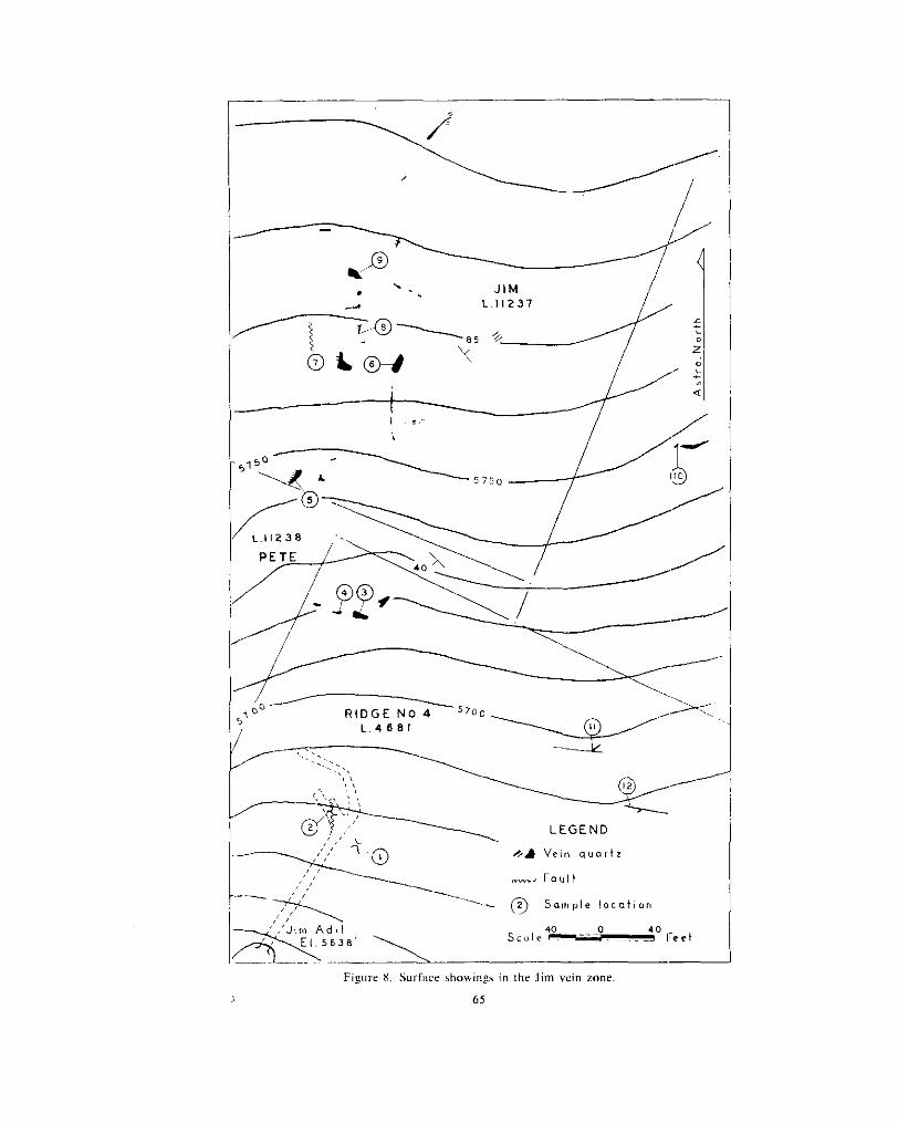
1 65
Jim The three Crown-granted claims Jim (Lot 11237), Pete (Lot 11238), and Ridge No. 4 (Lot 46811, and the Crystal group
II 51 Lieut.-Col. F. H. M. Codville, of Duncan. Quartz veins are exposed of recorded claims adjoining them on the north, are held by
in surface strippings in an area about 500 feet long and 200 feet wide (see Fig. X ) . These surface showings constituting the Jim vein zone are near the southeast corner of the J im claim. An adit whose portal is on the Ridge No. 4 claim and about 300 feet south of
of the vein zone. its northwest corner has been driven about 200 feet to explore the downward extension
A few small quartz veins were noted by Bowman* on Horseshoe Gulch7 at the head o f Luce Creek, but the prospecting and stripping of the veins in the J i m zone was done by Colonel Codville, who located the Jim and Pete claims in June, 1936, and the ground now covered by the Crystal group in 1938. The adit was started in 1946. The claims are underlain by northwesterly striking, hard grey quartzites of the lower and middle Snowshoe members. These lie in a syncline whose western limit is an anticline of Midas black silty quartzite at the northwest corner of the Pete claim and whose eastern limit is a narrow anticline of Midas black silty quartzite at the northeast corner of the Jim claim.
Snowshoe Creek. Its axial plane is close to the Jim vein zone and trends southeastward This structure, the Jim syncline, is continuous from Horseshoe Nail Gulch to French
through the Jim claim.
east corner of the Jim claim has exposed a large number of veins which lie in a zone Surface stripping in the northwest corner of the Ridge No. 4 claim and in the south-
about 500 feet long and 200 feet wide and whose general trend is a few degrees west of north. Many of the vein outcrops are incompletely exposed, and many of them seem irregular in outline. Their irregularity in shape is the result of the veins forming along two intersecting fracture sets, one striking northeastward (north 40 to 60 degrees east) and the other striking eastward (north 80 degrees east to south 80 degrees east); few veins occupy a simple fracture of one direction or the other. As a rule one fracture direction dominates, and offshoots from the vein occupy fractures having the other direction. Commonly veins shown in Figure X strike north 45 degrees east with off- shoots striking north 80 degrees east.
The quartz ranges from small veinlets a few inches wide to masses from 4 to 6 feet across. In general, the quartz is sparsely mineralized with pyrite and galena. Visible
gold assays have been obtained from some samples, and visible gold is reported to have gold may be present in and around areas from which pyrite has been leached. High
northwest of the northwest corner of the Ridge No. 4 claim. been seen in several outcrops. Most visible gold was seen in thc vein about 50 feet
Several northerly striking faults, which offset the veins a matter of a few feet, are seen in the open-cuts. The two veins about 300 feet northeast of the Jim adit are cut by steeply dipping faults striking north 70 degrees east, on which the movement is very small. Striations on the fault planes plunge 70 degrees west.
66

The sample locations are shown on Figure 8. The following tabulated assays are of samples taken from the vein outcrops in 1950.
SAMPLING OF JIM VEINS ON SURFACE
The Jim a dit
Figure 9. l im adit. showing veins and sample locations.
was started in 1946 to exulore the Jim vein zone at deD th. The oortal i s about 320 feet south of the northwest corner of the Ridge No. 4 claim. The eleiation of the portal is 5,638 feet, and that of the vein outcrops ranges from 5,670 1.0 5,790 feet. The adit (see Fig. 9) is driven north 33 degrees east for 105 feet, where it is crossed by a northerly striking fault. One branch 40 feet long was driven northward along the west side of the fault, and another 93 feet long was started on the east side of the fault but
67
crossed hack to the west side near the face of the drive. Thc northerly striking fault is exposed in two places underground as a gouge zone 2 to 4 feet wide. I t has a strike of north 8 degrees west and a steep westerly dip. Thc amount and relative direction n f movement are not known. All the veins underground, of which there are many, strike northeastward (about north 70 degrees east) and dip steeply southward. They range in width from a few inches to 30 inches, but most are less than 12 inches wide. The veins are sparsely mineralized with pyrite and Ealena and modcrate amounts of ankerite. High gold assays are obtainable from concentrations of pyrite (.SUP salnple Nos. I and 3 of Fig. 91, hut most assays are low because of the small pyrite content.
Assays of samples taken in the .linl adit are listed in thc following table. Sample locations are shown on Figure 9.
.. . . . . ~~~
ASSAYS O F SAMPLES FROM JIM AOIT ~ . ~_______ . ~~ ~~~~~~ .
The Midas property consists of a number of Crown-granted min- Midas era1 claims, of which the more important are the Saddle (Lot
4668), Saddle Extension (Lot 4669), Midas (Lot 4670), Midas Extension No. 2 (Lot 4671), Midas Extension No. 1 (Lot 4673).
West Midas Extension No. 1 (Lot 4677). and A. T. Fraction (Lot 4674). These and others are owned by Lieut.-Col. F. H. M. Codville, of Duncan. The claims lie east and northeast of the summit of Yanks Peak and on the top and sides of thc ridge between the head of Luce Creek and French Snowshoe Creek.
1 860’s. Bowman’s map shows the position of the Steele Ledge and the Galena Ledge, Many of the known veins were found at the time of the first quartz stakings in the
vein. The Saddle vein, as currently known, cannot be identified with any described by which probably are the ones now known, respectively, as the Tait vein and the Lipsey
Bowman. Interest in quartz veins dwindled after the first stakings in the 1860’s and 1870‘s.
and very little work other than a small amount of surface prospecting was done at that time. In the early 1920’s J. Glover and 0. J. Pickering began prospecting in the vicinity of Yanks Peak, and in 1923 they located the Saddle and Saddle Extension claims (Lots
ceeding years Glover and Pickering drove a crosscut adit southeastward for about 500 4668 and 4669) to cover their discovery (or rediscovery) of the Saddle vein. In suc-
Mining and Smelting Co. Limited took an option on the Saddlc. Midas. and associated feet to explore the vein at a depth of about 11 7 feet below its outcrop. In I933 Britannia
claims and organized Saddle Mines Ltd. This company, during 1933 and 1934, sank a shaft on the Saddle vein to connect with the crosscut driven by Glover and Pickering
and other veins in that vicinity. In 1938 Cariboo Mines Ltd. was organized by Amparo and did some surface trenching and prospecting to the northeast on the Tait, Lipsey,
of claims as well as others northeast of the head of Luce Creek. The company built the Mining Co. Ltd.. of Philadelphia. This company acquired the Saddle and Midas groups
camp at Snarlberg, built the road up the hill to the old camp at the Midas, drove a long exploratory crosscut at the Midas, and did about 35,000 feet of bulldozer stripping before stopping work in IY40. When the Amparo company went into voluntary liqui-
hR
r19,201

dation, Lieu[.-Col. F. H. M. Codville bought certain of the Crown-granted mineral claims. During 1948 Colonel Codville installed a 15-ton Gibson ball mill and a Wilfley table in a log building at the portal of the Midas adit, and in late July, 1949, began to (concentrate ore mined from a sublevel in the Saddle shaft. This operation was unprofitable, and was stopped i n September. 1949, after gold-bearing concentrates having a g m s value of $438 had been produced.
The quartz veins of chief interest on the Midas property, the Saddle. Lipsey, Tait,
Yanks Peak. They are in a belt of Midas formation that extends northwestward from Slim, and others, are exposed on the top and southeast slope of the northeast ridge of
hclt is hounded by the rather sinuous trace of thc Yanks Peak quartzite wtlich crosscs French Snowshoe Creek (see Fig. 2 , Sheet A, and Fig. 1 1 ) . On its western side the
slopes. swings to a more northerly direction through the western part of the Saddle Frcnch Snowshoc Creek at J . Sockett's showing, runs northwestward up the lower valley
Extension claim (Lot 4669). and then swings northwest and west across the north facc of Yanks Peak at elevations between 5,500 and 6,000 feet. The eastern side of the belt is i n contact with the Snowshoe formation which extends in a fairly straight line north- westward from Snarlberg. On top of the ridge the belt has a width of about 3,500 feet.
All the various types of rock making up the Midas formation are exposed, the predominant types being medium- to dark-grey argillaceous or sericitic schist; and black silty quartzitc.
They arc on thc overturned limb of the large Yankee Belle anticline whose axial planc In the vicinity of the veins thc rocks strikc northwest and dip steeply southwest.
lies about 1,800 feet west of the peak. The rocks within the belt are m o s intricately folded-an interpretation of thc internal structure was made on page 29 and is illustrated by the traces of the Midas quartzite on Figure 1 1 .
age of relativcly incompetent beds. Apart from dragfolds, the main featxes of the The complexities of the smaller-scale folding are the result of dragfolding and Row-
internal structure are two anticlines which may he thc southerly extensions of the two :Inticlines lying north of Little Snowshoe Creek.
Saddle Vein [20].-The Saddle vein is at 5,765 feet elevation on the top of the
claim. ridge 2.300 feet east of Yanks Peak. The vein is near the southern margin of the Saddlc
Glover and Pickering exposed the vein in an open-cut about 40 feet long. From it Lay* in 1929 obtained five samples of the vein, which assayed: Gold, 2.24 oz. per ton across 7 feet; Fold, trace across 2 % feet; gold, 0.08 07. per ton across 3 fee': 10 inches; gold, 3.34 02. per ton across 1 !'2 feet: and gold, 0.M oz. per ton across 2% feet. I n 1930 Lay again sampled the vein in the open-cut, with the following results:? Gold, 0.78 oz. per ton across 2 feet 7 inches; gold, 3.84 oz. per ton across 5 feet 3 inches; gold, 0.75 oz. per ton across 2 feet I 1 inches; gold, 0.83 oz. per ton across 4 feet; gold, 0.36 oz. per ton across 4 feet; gold, 0.50 oz. per ton across 3% feet; and gold, 0.30 02. per ton across 6 feet.
drovc a crosscut adit southeastward for ;I distancc of about 500 feet to explore the vein From the wcst side of the ridge at an elevation of 5,647 feet, Glover and Pickering
;jt a depth of about I 17 fcct below thc outcrop. Thc portal of the adit is caved. and these lower workings are inaccessible.
connect with the adit. Although the lowcr part of the shaft is now inacccss:ble, a copy in I933 Britannia Mining and Smelting Co. Limited sank a shaft on thc vcin to
of the assay plan of sampling done in the shaft by the Britannia company was made available hy Mr. Pickering. The assays and widths of vcin are shown on Figure 10.
level 9 feet north and 18 feet south. About 50 tons of vein quartz was hauled to the nlill In 1949 Colonel Codvillc hulkheaded the shaft at a depth of 37 feet and drove a sub-
at the portal of the Midas adit and milled in August, 1949. -
* ,Min, , , i~r 01 .Miner. n.C~., Ann. R a t . , 19ZY, n. 191. .M,,?;,~,,, ,,I uwr.,. R c.. ,tnn. ~ ~ ~ 1 . . 19x1, P. 170.
hY

Figure 10. Assay plan of the Saddle shaft.
The Saddle vein is exposed in an open-cut for a length of about 80 feet. South of the shaft it pinches to 1 foot in width, and north of the shaft it maintains a width of about
of the northerly striking fault whose zone it occupies. There has been post-mineral move- 4 feet for about 60 feet. The vein terminates abruptly at its northern end against a branch
ment along the east side of the vein, and striations on the walls, seen both at surface and underground, plunge ahout 20 degrees south. The amount of displacement along the fault is not known. The vein strikes about north 5 degrees west, dips 65 to 80 degrees cast, and cuts across the Midas rocks, whose general strike is about north 40 degrees west.
A band of Midas black silty quartzite about 100 feet wide and outcropping for a length of about 300 feet lies on the west side of the Saddle vein and is truncated by it. The Midas black silty quartzite band is thought to occupy an anticlinal septum, but its relation- ship to the complexly dragfolded structure about 400 feet southeast is not apparent. The rock on the east side of the vein is grey argillaceous and sericitic schist, and no extension of the black silty quartzite is to be seen.
A wide crush zone, parallel to the formation and about 200 feet west of the Saddle shaft, is exposed in bulldozed trenches for more than 2,000 feet. It is not known whether this crush zone is a strike-fault or not (see p. 34) .
in the shaft, solid pyrite about 3 inches thick lies along the footwall of the vein. A few The Saddle vein is mineralized with pyrite and some galena. At a depth of 37 feet
vein fragments on the dump were seen to contain visible gold in the quartz as well as in cavities from which pyrite had been leached.
and 1950. The locations of surface samples are shown on Figure 1 1 . The assays in the following table are of samples of Saddle vein quartz taken in 1949
70
SAMPLES FROM SADDLE VEIN
Sample NO. on Width Fig. 11 1
46
41
4x
sn 49
FI. In.
~ ~~.
4 0
4 2
4 0
4 0 2 6
and other unnamed veins, outcrop on the top and east side of the ridge between French Midus Vein Zone.-The Midas veins, which include the Tait, Lipsey, Slim, Allan,
Snowshoe Creek and the head of Luce Creek. They are about 1,000 feet northeast and east of the Saddle shaft. Two veins in that general area are shown on Bowman’s map of Little Snowshoe Creek, and it is probable that the Steele Ledge is now called the Tait vein and the Galena Ledge the Lipsey vein.
and 1934, but most work was done by the Amparo company. This company stripped The Britannia company did some surface stripping and sampling of the veins in 1933
and sampled all the known veins, and in the process of doing about 35,000 lineal feet of bulldozer stripping discovered numerous other veins. The bulldozer trenches explore the band of Midas formation between its contacts with the Yanks Peak quartzite and the basal Snowshoe member, from the fifth switchback above Snarlberg across to the Saddle shaft and uphill to the crest of the ridge. Were it not for the bedrock exposed in these trenches, the geological mapping of this area would be impossible.
which, with other rock types, comprise the Midas formation. With very few exceptions, Figure 1 1 shows the distribution of the several members of black silty quartzite
all the Midas veins are in grey argillaceous and sericitic schists rather than in black silty quartzite or ankeritic rock.
vein on top of the ridge at 5,690 feet elevation for about 2,000 feet downhill in a direction Most of the veins lie in a single zone (see Fig. 11) which extends from the Allan
south 15 degrees east to about 5,375 feet elevation. This zone outcrops within an area of grey argillaceous schist which is flanked on the west by middle Midas black silty quartzite and on the east by upper Midas black silty quartzite. These rwks lie in a
wedge-like cross-section is a shape imposed by regional structures, and conr,equently it wedge whose apex at about 5,350 feet elevation points downward (see pp. 29, 30). The
is believed that its apex will plunge northwestward parallel to the 20-degrm:e regional plunge.
A few veins lie outside the main vein zone and are part of no recogni:sable zone.
within the Midas vein zone. A few near the crest of the ridge have been named, mainly About twenty-five large veins as well as other narrower and shorter ores outcrop
because they are large or contain visible gold, but the rest are not designated separately. The individual veins strike northeastward or eastward. Some of them are straight,
but others are either slightly curved or step-like because alternate sections (of the vein
fracture direction is north 60 to 70 degrees east, and entire veins or segments of veins occupy one of two main fracture directions (see p. 40 and Fig. 6 ) . One prominent
may have this strike. The other fracture direction ranges from north 80 degrees east to south 80 degrees east. Some veins may have this strike or be composc:d of short
71

segments whose strike may vary 10 to 15 degrees from it. Other vcins combine segments occupying fractures that strike northeastward and eastward.
veins are commonly between 12 and 20 inches wide. The longest vein, the Slim vein, Although the veins range in width from a few inches to a maximum of 4 feet, most
is about 175 feet long, and the others are considerably shorter. The veins are all sparsely mineralized with pyrite and less abundant galena.
Ankerite is present in most veins, either disseminated throughout the vein or as a narrow
is reported to have been found in several others downhill from the Slim vein. It is selvage along the vein wall. Visible gold is present in the Teit and Station 4 veins, and
possible to pan fine gold from broken material at the outcrops of several veins.
sample locations are shown on Figure 1 I . The following assays are from samples obtained from the Midas vein zone. The
6 I
Y 1 0 Il 12 13 14 IS
I? 16
19
20 2 i 22
?4 23
25 26 27 28 29 3 0 31 32 33 34 35 36 31
8
18
3 x
39
41 40
42 43
"
sliver
~~~ ~~
)i. per 'TU11 0.9 Nil
Nil Nil
Nil Nil
Nil Nil
,Nil Nil Ni l Nil Nil
Nil
Nil N i l
Ntl Nil
Nil '31 lVll NlI
NIi Nli
Nil Nil Nil Nil Nii ,Vi1 Nil Nil
Nii Nil Nil Nil Nil
Nii ~
Lipsey and Other Veins.-Three large outcrops of quartz lie just west of the Midas vein zone and close to the eastern edge of an anticline o f middle Midas black silty quartzite. An open-cut has been made on each quartz outcrop, but continuity has not been proved between them. They are thought to represent segments of three separate northerly striking veins.
The northernmost outcrop exposes a lens of vein quartz having a maximum width of 11 feet tapering to 3 feet and 6 feet at the ends of the open-cut. Two samples
12

containing unreplaced fragments of wallrock and no visible pyrite-assayed: Gold, nil. (Nos. 1 and 2 on Fig. 11)-one across 11 feet and the other across 2 % f w t of quartz
and north of the outcrop exposes a 12-foot piece of quartz which may he a large boulder. The centre open-cut exposes the Lipsey vein continuously for a length of 30 feet,
The Lipsey vein strikes slightly west of north and dips steeply to the east. It occupies a small northerly striking fault zone. The vein is mineralized with galena and less pyrite and sphalerite. Visible gold is present in unmineralized quartz as well as in
mineralized quartz (Nos. 3 , 4, and 5 on Fig. 11) assayed: Gold, nil across 3% feet; and around cavities from which pyrite has been leached. Three samples of sparsely
is shown on Bowman’s map as the Galena Ledge. gold, 0.06 oz. per ton across 8 feet; and gold, 0.07 oz. per ton across 4 feet. This vein
The southern open-cut exposes shattered quartz for a length of about 25 feet. A shear along the east side strikes north 20 degrees west, and a narrow prong of quartz extends southwestward from the main mass along a fracture. A sample (No. 26 on Fig. 11) across 3 feet 4 inches of massive quartz containing sparse pyrite and galena, and showing visible gold near the galena mineralization, assayed: Gold, 0.13 oz. per ton.
northwest side of the ridge at the head of Luce Creek to explore the downward extension Midas Adit [19].-The Amparo company drove a crosscut southeastward from the
of the Midas vein zone and of the three large veins just west of it. Neither the company’s plans of the crosscut and surface workings nor their extensive assay plans are available. The plan in Figure 12 is from a tape and compass survey of the workings.
All the workings are accessible, except for a short section which is caved near the end of the second crosscut on the west side. The air is good for about 500 feet in from the portal, but beyond that point there is a deficiency of oxygen and a match or candle will not burn. Safety precautions should be observed by anyone examining these workings.
hearing south 36 degrees east, and ahout 1,300 feet of lateral workings, drifts on veins, The Midas workings consist of an almost straight crosscut about 1,200 feet long
and exploratory crosscuts (see Fig. 12). The rocks exposed underground are dark-grey ankeritic argillaceous schists and
slates with some thin quartzite layers. No black silty quartzite correspomling to the middle or upper Midas black silty quartzite was identified. No beds seen on surface could he correlated with any exposed underground, and no interpretation of the folding within the wedge-shaped mass could be made (see p. 29). A northerly striking fault crosses the workings and appears in three places as a zone of shattered rock about 20 feet wide. The direction of movement on this fault is unknown, and althoxgh the dis- placement is unknown, it is thought to be small in amount. At least three other small northerly striking faults are exposed in the underground workings.
ward continuations of the three large northerly striking veins exposed on surface. In Crosscuts were driven on the west side of the main adit in an attempt to find down-
the crosscut beneath the most northerly vein there is a swarm of small qua& veinlets
faulted rock was encountered in the crosscut below the Lipsey vein. This may be the and an area of partial silicification, hut there is no vein. A wide zone of sheared and
crosscut beneath the southernmost vein did not cross any quartz corresponding to the same shear as that exposed on surface, hut there is no vein in it underground. The
surface showing.
which strike north 50 to 60 degrees east and dip steeply southeast, or which strike about The working intersects at least twenty quartz veins. The veins occupy fractures
south 85 degrees east and dip steeply south. The easterly striking veins have short, narrow offshoots striking northeastward. Some of the easterly striking veins have been followed by drifts as far as 150 feet. Four such veins on the east side of the: main adit from 800 to 1,200 feet from the portal are directly beneath outcrops of the IMidas vein zone, hut the veins exposed underground are not necessarily the same as those exposed on surface.
4 73

74
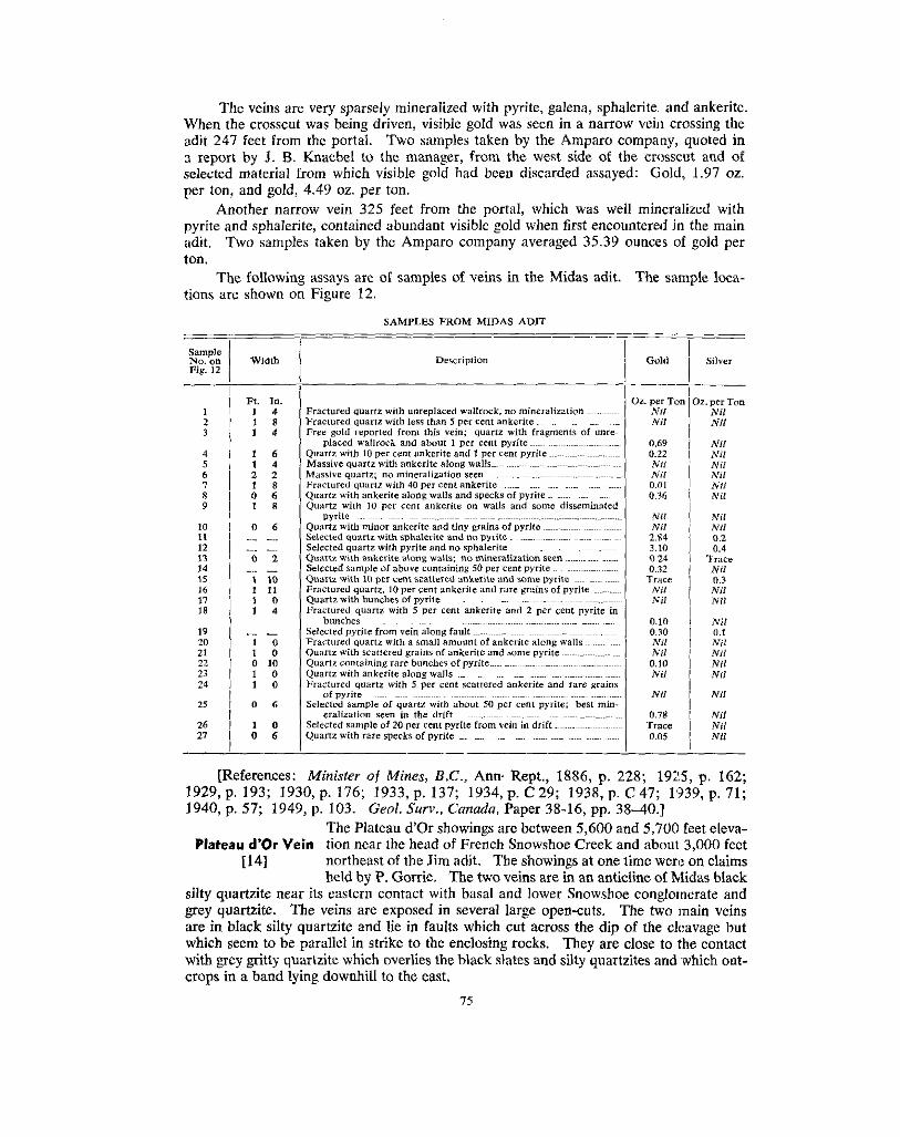
When the crosscut was being driven, visible gold was seen in a narrow vein crossing the The veins are very sparsely mineralized with pyrite, galena, sphalerite, and ankerite.
adit 247 feet from the portal. Two samples taken by the Amparo company, quoted in
selected material from which visible gold had been discarded assayed: Gold, 1.97 02. 3 report by J . B. Knaebel to the manager, from the west side of the crosscut and of
per ton, and gold, 4.49 oz. per ton.
pyrite and sphalerite, contained abundant visible gold when first encountered in the main Another narrow vein 325 feet from the portal, which was well mineralized with
adit. Two samples taken by the Amparo company averaged 35.39 ounces of gold per ton.
tions are shown on Figure 12. The following assays are of samples of veins in the Midas adit. The sample loca-
__ __ Sample No. on Fig. 12
2 1
3
4 5 6 7 R 9
10 11 12 13 14 15
17 16
18
19
21
23 22
24
25
26 27
20
-
Fl. In. 1 4 1 8 1 4
1 6 1 4
0 6 1 8
1 8
0 6
a 2
.~~.
.~. 0 2
I 10 1 11 1 0 1 4
." -
"
1 0
0 10 1 0
1 0 1 0
0 6
0 6 1 0
SAMPLES FROM MIDAS ADIT
>z. per Tor Nil Nil
0.69 0.22
Nii Nil
0.36
Nil Nil 2.84
0.24
Trace 0.32
Nil Nil
0.10 0.30 Nil Nil 0.10 Nil
Nil
0.78 Trace 0.0s
0.01
3.10
2. per Ton Nil Nl i
Nil Nil Nil Nil Nil Nil
Nil Nil 0.2
Trace 0.4
Nil 0.3 Nil Nil
Nil
Nil u.1
Nil Nil Nil
Nil
Nil Ni i Nil
1929, p. 193; 1930, p. 176; 1933, p. 137; 1934, p. C29; 1938, p. C47; 1'339, p. 71; [References: Minister of Mines, B.C., Ann Rept., 1886, p. 228; 19:!5, p. 162;
1940, p. 57; 1949, p. 103. Geol. Surv., Canada, Paper 38-16, pp. 38-40.] The Plateau d'Or showings are between 5,600 and 5,700 feet eleva-
Plateau d'0r Vein tion near the head of French Snowshoe Creek and about 3,000 feet
silty quartzite near its eastern contact with basal and lower Snowshoe conglomerate and held by P. Gorrie. The two veins are in an anticline of Midas black
grey quartzite. The veins are exposed in several large open-cuts. The two main veins are in black silty quartzite and lie in faults which cut across the dip of the cleavage but
with grey gritty quartzite which overlies the black slates and silty quartzites and which out- which seem to be parallel in strike to the enclosing rocks. They are close to the contact
crops in a band lying downhill to the east.
[I41 northeast of the Jim adit. The showings at one time wen: on claims
7s

The eastern vein appears to he the more continuous and occupies a fault which strikes Both main veins are exposed in a long open-cut at the northern end of the showings.
north 25 degrees west and dips 80 degrees to the northeast, cutting across the 40-degree northeasterly dipping beds. Drag structures suggest that the downthrow side is on the east. This eastern vein is about 3 feet wide in the open-cut and reaches a maximum width of 8 feet in outcrops 50 feet to the south. It is exposed in open-cuts on both sides of a draw 125 feet to the south. On the north side of the draw the vein is about 4 feet wide and is seen to contain a small amount of pyrite. A selected sample of quartz con- taining about 10 per cent pyrite and some lacy-textured marcasite assayed: Gold, nil. On the south side of the draw, vein quartz having a width of 4 feet at surface pinches out at a depth of 8 feet. The southernmost exposure is 240 feet south. There, what is pre-
from the southwest by a vein 24 to 28 inches wide, striking north 65 degrees east, and sumed to be the east vein, about 2 feet wide and striking north 25 degrees west, is joined
mineralized with black sphalerite and galena in irregular concentrations. Several open- cuts farther south do not appear to have encountered any vein quartz.
The west vein is exposed in the large open-cut at the north end of the showings. It is 30 feet west of the east vein, is 4% feet wide, strikes north 25 degrees west, and
farther south and about 24 feet west of the east vein there is a large amount of vein stands vertical. Sixty feet south 2 feet of quartz is exposed in an open-cut, and 95 feet
quartz which, from Lang's description,* has a maximum width of 8 feet. At present one sees only a width of 2% feet. The quartz is honeycombed with cavities from which pyrite has been leached, and is mineralized with some galena. The west vein is not traced south of this point, and even its northward continuity between open-cuts may be
no recent work has been done. uncertain. Undoubtedly more could be seen when the open-cuts were newly made, hut
[Reference: Geol. Surv., Canada, Paper 38-16, pp. 35, 36.1
Penny 4, 5, 6, claims are held by Joseph and Elizabeth Wendle, of Barkerville. The Penny 4, 5 , 6, and 7 Fractions, Par, and Uneven Fraction
and 7 Fractions, They are on Peter Gulch and extend downstream on the northeast Par, and Uneven side of the creek from the Uneven Fraction at the mouth of Copper
Fraction 131
Creek. These claims are relocations of others which formerly constituted the Cariboo Thompson (Rand) property and which
inary Paper 38.16, pages 24 to 26, under Wendle group. were described by Lang in Geological Survey of Canada Prelim-
eastern overturned limb of the Snowshoe syncline. The claims are underlain by lower and middle Snowshoe quartzite in the north-
The main showings are gold-bearing quartz veins on the Par and Uneven Fraction
twelve ground-sluice cuts, each about 300 feet long. These cuts have exposed several claims. The lower hillside downstream from Copper Creek has been prospected by
quartz veins, of which one about 200 feet east of the northeast corner of the Cunningham Extension No. 1 (Lot 5908) has received most attention. The vein strikes north 5 degrees west and occupies a shear in basal Snowshoe grit and pea-pebble conglomerate. Striations on the walls of the shear plunge 20 degrees north. A drift, the Coniagas adit, was driven along the vein for 110 feet, and at 35 feet from the portal a winze was sunk to a depth of 26 feet. In the drift, from records of work done, the vein averages 1.7 feet wide, and the average of thirty-two assays is 1.3 ounces of gold per ton (sampling by Island Mountain Mines Company Limited).
In January, 1937, a shipment to the Trail smelter of 3.9875 tons of cobbed ore from the vein assayed 1.63 ounces of gold per ton and 2.6 ounces of silver per ton. It
In the autumn of 1938, 9.9615 tons of cohhed ore shipped to the Department of Mines is reported by Stevenson+ that this shipment contained about 500 pounds of scheelite.
sampling plant at Prince Rupert assayed: Gold, 3.71 oz. per ton; silver, 1.25 oz. per *Gaol. Sur".. Conado, Paper 38-16. P. 35. tB .C. De@. of Mines, Bull. 10 (Rev.). 1943.P. 90.
76
ton; and arsenic, 7.1 per cent. About 8 tons of this shipment came from the vein in the Coniagas adit and winze, and the remainder, of about 2 tons, was from a vein on the west side of Peter Gulch about 150 feet west of the portal of the Langley adit.
The portal of the Langley adit is about 60 feet lower in elevation th,m and about 50 feet west of the northeast corner of the Cunningham Extension No. 1 (Lot 5908). It consists of a crosscut driven south 60 degrees east 325 feet to the vein and 130 feet of drifting on the vein. The portal of this adit is caved.
In 1946 Cariboo-Hudson Gold Mines (1946) Limited held an option m the claims and drilled fourteen diamond-drill holes totalling 2,557 feet without encouraging results.
The other principal gold showing is a small northerly striking vein near the mouth of Copper Creek. The vein strikes north 10 degrees east and occupies a shear in Snow- shoe argillaceous quartzite and grit. The shear dissipates itself along fractures parallel- ing the foliation planes. The quartz is stripped for about 75 feet on the west side of Copper Creek and is mineralized with pyrite and some scheelite. On the east side of the creek the vein is followed by a drift for a short distance in an adit now caved. Pyrite in the vein is irregularly distributed and the gold content is low.
to and about 150 feet west of Copper Creek. A selected sample containing about 50 A 6- to 10-inch northerly striking vein is exposed in a ground-sluice cut parallel
per cent pyrite assayed: Gold, 0.36 oz. per ton. [References: B.C. Depf. of Mines, Bull. No. 10 (Rev.), 1943, pp. 90-512. Minister
Surv., Canada, Preliminary Paper 38-16, pp. 23-26.] of Mines, B.C., Ann. Rept., 1938, pp. B 36, C 47; 1940, p. 57; 1943, p. 78. Geol.
Skarn Nos. 1 and 2 and W. E. Thompson, of Barkerville. The claims cover scheelite The Skarn Nos. 1 and 2 mineral claims are held by Dan Jorgenson
of the scheelite showings were described under Rand (Cariboo Thompson) by Stevenson discovered tetrahedrite-bearing quartz vein to the north. Some
in British Columbia Department of Mines Bulletin No. 10 (Revised), 1943, pages 90 to 92.
below the bridges. In this vicinity the upper Midas black limestone is overlain by Snow- The contact between the Midas and Snowshoe formations crosses Copper Creek
shoe quartzite and all rocks are closely and repeatedly folded so that the same limestone bed outcrops as a number of parallel ribs. The Copper Creek fault, inferred because of the lateral displacement of the Midas-Snowshoe contact, is believed to cross Copper Creek about 650 feet downstream from the forks of the creek.
extend about 200 feet upstream and 600 feet downstream from the eastern of the twin The showings are exposed naturally and in open-cuts along Copper Creek. They
bridges. They are in Midas rocks on the east side of the Copper Creek fault. There are several showings above the bridge on the south branch of Copper Creek.
An open-cut in black slate on the east side about 200 feet above the bridge exposes narrow quartz stringers across a width of 16 feet. Some copper stain is evident, and scheelite, which is light coloured and not readily seen otherwise, is visible under ultra- violet light. The best scheelite mineralization occurs on the footwall side o f the zone and is estimated to contain about 3 per cent tungstic oxide across a width of about 3 feet,
The zone of quartz veins apparently crosses to the west side of the creck and out- crops about 50 feet downstream from the bridge, but at that point contains no scheelite.
On the west side of the creek and upstream from the bridge several open-cuts expose vein quartz as much as 30 inches wide occupying shears which partly cut the foliation and are partly parallel to it. The quartz is irregularly mineralized with scheelite.
by a shear which strikes north 10 degrees west and which has a right-hand displacement of On Copper Creek 150 feet downstream from the forks a rib of black limestone is cut
a few feet. The shear is occupied by 3 to 4 feet of vein quartz, and the limestone walls are 77
P I showings on Copper Creek near the twin bridges and a newly
well mineralized with scheelite. This showing was discovered by Stevenson in 1942 and is described* by him as follows:-
a compound quartz zone 42 inches wide which consists of 2 lenses of quartz striking north 10 An open-cut has been driven south-easterly for 6 feet to a face 6 feet high. The cut exposes
degrees west and dipping 65 degrees eastward. The hangingwall-lens is 1 foot wide and the
schist. The hanging-wall is grey, talcose schist, strike north 50 degrees west and about vertical, footwall-lens is 16 inches wide. They are separated by 14 inches of badly crushed, graphitic
but the footwall is grey, massive limestone. The mineralization in these lenses consists of quartz. scheelite and small amoonts of tetrahedrite, galena and sphalerite. Most of the scheelite in the zone is in the footwall-limestone immediately adjacent to the vein-wall. Here the scheelite ~ccurs as high-grade patches of mineral measuring up to 4 feet by 16 inches in surface area, but probably only a few inches in thickness. Insufficient work has been done to determine the continuity of these patches northerly along the strike of the zone. Smaller amounts of scheelite occur as ribbons of discontinuous grains in and near the foot-wall of the footwall-lens.
and the abundant crushed rock within the zone indicate much post-mineral movement. The A gouge seam, 1 inch thick, lies in the hanging-wall of the hangingwall-lens. The gouge
strike of the schist and its position relative to the limestone suggest that the west side of the zone has moved northerlv.
The following samples were taken on the showing:. Footwall-lens-
3 feet from floor; 16 inches wide . ~ ~ ~ ~ ~ ~ ~ ~ . . ~~~~~~~. . ~ ~ ~ ~ ~ . . 0.2 5 feet from floor; 14 inches wide ~ ~~~~~~~~ . ~ ~ ~ ~ ~ ~ . ~ . trace
1 foot from floor; across 14-inch patch of mineralization, vertical^..^ 12.6 I foot from floor; across 14-inch patch of mineralization, horizontal 18.2
Footwd-limestone-
One hundred and twenty-five feet farther down the creek another rib of black lirne- stone is cut by a northerly striking shear having a left-hand displacement of about IO feet. The shear contains small amounts of scheelite and purple fluorite.
veins mineralized with tetrahedrite cross the creek. Three hundred feet farther down the creek, near some diabase dykes, several narrow
between the two Copper Creek bridges. The vein is 18 to 30 inches wide and is con- A quartz vein is exposed by trenching and open-cuts on the north side of the road
tinuously exposed for 80 feet in a trench between the road and the east fork of the creek.
and scheelite. A 30-foot length of vein 12 to 18 inches wide is exposed on the north side It occupies a northerly striking shear. The quartz is mineralized with pyrite, tetrahedrite,
is no greater between limestone walls. The limestone is replaced across a narrow width of the creek. The vein crosses a bed of limestone, but the amount of scheelite in the vein
by pyrite, of which a selected sample assayed: Gold, trace. On the south side of the creek a wedge-shaped horse of quartzite splits the vein where it has a maximum width of 4 feet. The vein at this point is estimated to contain about 3 per cent tungstic oxide.
sparsely mineralized with tetrahedrite and scheelite. Ninety feet farther downstream another northerly striking vein 6 to 18 inches wide is
north of the bridge across the northern branch of Copper Creek. The vein strikes about During the summer of 1951 Dan Jorgenson discovered a new vein about 500 feet
north 40 degrees east and is exposed in two open-cuts 35 feet apart. About 75 feet farther uphill a band of limestone outcrops along the hillside. The lower open-cut exposes
amounts of scheelite. A selected sample well mineralized with tetrahedrite assayed: 14 feet of quartz mineralized with pyrite, galena, sphalerite, tetrahedrite, and very small
Silver, 62.4 02. per ton. [Reference: B.C. D e p f . of Mines, Bull. IO (Rev.), 1943, pp. 90-92.1
Snowshoe Gold Mines Limited, Room 209, 602 Hastings Strect Snowshoe Gold West, Vancouver, owns Lots 11332 to 11346. These fifteen Miner Limited Crown-granted claims are near the head of Luce Creek on the
[I61 north side of the valley, due north of Yanks Peak. They were formerly known as the Jane group. On their eastern side they
adjoin the J i m group, and on the southeast the Midas. * B.C. DsprofMines. Bull. NO. 10 (Rev.), 1943, pp. 91,92.
78

Timer (Lot 11337). This, the first quartz vein found in the Keithley Creel; district, was In 1862 a quartz vein was discovered on ground which is now includ'sd in the Old
discovered by Thomas Haywood and Edward Jeffrey, who named it the Ilouglas vein. It is so named on Bowman's map of Little Snowshoe and Keithley Creeks. Later it has been known as either the Haywood vein or the Arrastre vein. Bowman ~records' that Haywood drove a YO-foot adit to tap the vein below its outcrop and that an arrastre built on the ground was unprofitably worked by William Luce on quartz from the vein. In
cleaned out the old adit and shipped some quartz for a test. There is no re8:ord of work 1886, after Haywood's death, the ground was relocated by Veith and Elorland, who
having been done for many years after 1887. The claims lapsed in the interval and were relocated by R. Reinhold in 1928. In 1933 the group was under option to Island Mountain Mines Company Limited, for which Reinhold drove a short adit on the south side of Luce Creek near the northeast corner of the Betty Fraction (Lot 112134). Rein- hold and partners optioned the Jane group to F. M. Wells, who in 1937 organized Snow- shoe Gold Mines Limited. The company built a camp and in 1938 began )underground
Pioneer Gold Mines of B.C. Limited took an option on the property and did some under- exploration which continued into 1939. The property was idle in 1940, and in 1941
ground exploration. Work by the Pioneer company ceased in January, 1942, and since then no further work has been done.
The claims are in part underlain by the dominantly argillaceous rocks o f the Midas formation and by conglomerate and grey quartzite of the Snowshoe formation, A contact between Midas formation on the west and Snowshoe formation on the east trends in a northwesterly direction through the northeast corners of the Old Timer (Lot 11337) and the Junior Fraction (Lot 11336).
11333) claims, the rocks are Midas argillaceous and grey sericitic schist, locally with thin On the Old Timer, Jane (Lot 11338), Bertha (Lot 11332), and Indian Broom (Lot
interbeds of quartzite and black silty quartzite. Upper Midas black silty quartzite out- crops between the northwest corner of the Old Timer and the northeast corner of the Junior Fraction. It is repeated many times by close isoclinal folding about essentially horizontal axes.
definitely known. The anticline just east of Aster B may extend southward through the The Midas rocks are involved in rather complex folding, whose details are not
central part of the Bertha claim, and the anticline at Breakneck Ridge may projNsct through the western part of the Indian Broom claim, but lack of outcrops makes it impossible to verify their presence. The intricacies of the smaller structures within the dominantly incompetent Midas formation remain largely conjectural, but they are thought to be com- parable to those studied in detail on the Midas claims. Insufficient outcrops of marker beds prevent detailed structural interpretations being made and prevent correlations between rocks exposed on surface and in underground workings.
An anticline, which brings a 200-foot hand of upper Midas black silty quartzite to the surface, lies along the eastern side of the Little Robert (Lot 11340) and Jnnior (Lot 11341). The Snowshoe rocks lying to the east and west of this anticline occupy a com- plex belt in which narrow ribbons of basal and lower Snowshoe alternate with ribbons of upper Midas black silty quartzite or ankeritic rocks.
road at a point about 600 feet east of the northeast corner of the Old Timer. An outcrop Float from a rhyolite porphyry dyke extends in a line uphill northwestward from the
about 150 feet long and 50 feet wide of altered diorite lies at 5,700 feet elevation on the ridge-top 300 feet east of the northeast corner of the Junior Fraction. These are the only known intrusive rocks on the property.
A wide fault zone is exposed in the hank just west of the portal of the Camp adit, in the Intermediate adit about 40 feet from the portal, and in the Lower adit 130 feet from the portal. This fault strikes a few degrees west of north and dips about 60 degrees to
GeoLSurv.. Conado,Ann. R e m , (1887-88),Vol. 111. Pt. LPt. C,P. 44c.
79


the southwest. Another fault, strike unknown, hut possibly slightly west of north, was encountered at the face of the Intermediate adit.
The main surface workings are on the Jane, Old Timer, and the Bertha (see Fig. 1 3 ) .
first discovery and are on the Jane and Old Timer close to camp, and the other, lying The workings are in two separate areas; one area includes the veins which c:onstituted the
about 1,200 feet to the north, includes several veins on the Bertha. The trenching and stripping around the principal showing was done mainly by Fred
Wells for Snowshoe Gold Mines Limited. Pioneer Gold Mines of B.C. Limited, during their short period of operation, bulldozed a single strip straight uphill hut did little strip- ping to the side of it. The cuts are now partly sloughed and the veins are imperfectly exposed in them, hut it is reasonably certain that several quartz veins ars: present and several others are indicated.
a length of about 150 feet. The vein probably extends south as far as a short adit which Open-cuts on the west side of the bulldozed strip expose a northerly striking vein for
passes beneath the road but which is now caved. This evidently is the same northerly striking vein that is followed by the Camp and Intermediate adits. Near the northern end of the vein and exposed in the bulldozed trench is a short lens of quartz as much as 3 feet thick, trending slightly east of north and separate from the first vein.
is a narrow quartz vein whose full length is not exposed. This vein probably is the original East of the bulldozed trench and extending southward from the upper Arrastre adit
Douglas vein discovered by Haywood. Several old surface cuts on it are caved and the
feet elevation, is 62 feet long and is driven in a northerly direction on the Douglas vein. southward continuity of the vein cannot he seen. The upper Arrastre adit, at 5,401
The rock exposed in it is light, biscuit-brown weathering sericite schist, all considerably oxidized and iron-stained because the adit is only a few feet below the surface. The vein,
Beyond, the adit follows a small northerly striking fault, hut there is no vein along it. 24 to 30 inches wide, is exposed for 12 feet south of the portal and for 10 feet within it.
ping 75 degrees northwest, extend laterally from the fault and cross the drift obliquely. Instead, quartz stringers a few inches wide, striking mostly north 70 degrees east and dip-
is thoroughly oxidized and in many veins is leached, leaving small cubical pils. The stringers are mineralized with pyrite, and visible gold is present in some. The pyrite
The lower Arrastre adit, elevation 5,362 feet, is 120 feet south of the upper Arrastre adit. The portal is caved and the workings are inaccessible. However, a survey of them was made in September, 1940, by B. T. OGrady, and the following information is derived from his notes. The adit comprises about 160 feet of workings consisting of a northerly drive of about 90 feet and a branch to the northeast about 60 feet in length. At 50 feet from the portal thcre is a raise to the surface, beyond which the adit follous a northcrly striking vein for 30 to 40 feet. Vein quartz in the face is about 5 feet wide, The north- easterly striking branch follows a vein which pinches out about 35 feet from the inter- section.
is the same as that in the outer part of the upper Arrastre adit. It is possible that the northerly striking vein in the face of the lower Arrastre adit
Old arrastre tailings are partly covered by the dump of the lower Arrastre adit. It is apparent that very little vein quartz was milled, other than the amount broken in driving the two adits. There is no stoping in the upper adit, and OGrady indicates that not more than 15 square feet of vein area could have been stoped in the lower adit. None of the assays suggests that the average grade of the vein quartz is sufficiently rich For profitable milling by arrastre. Evidently the same conclusion was reached through experience by Hayward and Luce. About 100 feet east of the portal of the lower Arrastn: adit are the remains of an arrastre which was never operated. The other is huricd beneath the dump.
Three adits-the Camp adit, Intermediate adit, and Lower adit-totalling about 1,850 feet were driven by Snowshoe Gold Mines Limited in 1938 and j.939 and by Pioneer Gold Mines of B.C. Limited in 1941. Thc same northerly striking vein that is exposed in surface trenches on the west side of the bulldozed strip is followed on both the
8 1

Camp and Intermediate levels. The northerly striking fault, accompanied by some vein
vein. quartz that crosses the Lower adit about 460 feet from the portal, is probably the same
The Intermediate and Lower adits cross a strong fault zone about 30 feet wide. This fault strikes a few degrees west of north and dips about 65 degrees west. It is seen only in the underground workings; neither its extension beyond them nor its surface expression has been observed.
240 feet. The rocks are mostly medium-grey soft argillaceous schists; some pale sericite The Camp adit, at 5,262 feet elevation, is driven in a northerly direction for about
schist appears near the face. The dominant schistosity dips steeply northeast and is crossed by a more widely spaced cleavage of a second generation dipping about 25 degrees northeast. About 80 feet from the portal, vein quartz reaching a maximum width of 16
the adit for about 75 feet. At that point the vein joins a northerly striking fault, strike inches and striking about 20 degrees east comes in from the west wall and is followed by
north 5 degrees west and dip 70 degrees east, of very small displacement. Vein quartz 18 to 22 inches wide follows along the fault for about 60 feet, at which point the vein appears to swing into the east wall. Striations on the smooth wall of quartz in the fault plunge 15 degrees south. The post-vein movement along the northerly fault displaces veins about 2% feet to the right. The quartz is mineralized with pyrite and a small amount of galena. Assays of samples are listed in the tabulation 011 page 84. From
zation. The veins occupy a single northerly striking fault of small displacement and them it is apparent that higher gold values accompany the more abundant pyrite minerali-
associated tension fractures striking about north 40 degrees east. The contemporaneity of quartz mineralization is shown by the merging of the small northeasterly striking veins with the larger northerly striking one.
The Intermediate adit, at 5,242 feet elevation, comprises about 700 feet of workings beneath the Camp adit. Most of the rocks are dark argillaceous schists which display a moderate to steep southwest-dipping schistosity and a gentle northeast-dipping fracture cleavage. A bed of ankerite rock is involved in some small-scale folding east of the fault zone near the portal. The fault zone on this level has a width of 35 feet and crosses the
flutings along minor shear planes within it plunge gently southward, parallel to the stria- adit 40 feet from the portal. The fault dips about 45 to 60 degrees west, and small
tions on the vein wall in the Camp and Intermediate adits. About 225 feet from the portal a 6- to %inch quartz vein comes in on the east wall of
the adit, expands to a maximum width of 24 inches, and occupies a well-defined northerly
corresponds with the northerly striking segment in the Camp adit about 20 feet above. trending fault for about 150 feet. The vein is sparingly mineralized wjth pyrite and
At the northern end of the quartz a narrow fracture branches to the northeast, and although the fault continues northward, no quartz appears along it. The northerly
places it about 3 feet to the right. striking fault is crossed by an easterly striking fault dipping 20 degrees south which dis-
Beyond the north end of the northerly striking vein, scores of narrow quartz veins, all striking about north 60 degrees east, cross the adit. Most of these veins contain little or no pyrite. High gold assays are obtainable from a narrow vein, well mineralized with pyrite, on the east wall opposite the first crosscut to the left, about 380 feet from the portal. The average of eleven samples taken by Pioneer Gold Mines of B.C. Limited along 30 feet of drift in this vicinity was about 0.3 02. gold per ton.
The Lower adit is at 5,148 feet elevation and is driven 650 feet at north 23 degrees east. From it 360 feet of drifts and crosscuts have been driven. The rocks exposed in it
slate and quartzite at the innermost end. A bed of ankerite rock probably is the same are dark argillaceous schist, black slate, and pale biscuit-coloured sericite schist, and black
one that appears in the upper levels. The rocks show two sets of cleavage, with the gently dipping second-generation set fairly prominent.
82

about north 25 degrees west, dips 65 degrees to the southwest, and appears to he more or A fault zone 40 feet wide crosses the adit 130 feet from the portal. The zone strikes
less parallel to the beds. At 260 feet from the portal a vein striking north 75 degrees east crosses the adit and
is followed for 90 feet to the northeast before the fracture disappears. The vein has a maximum width of 10 inches and is poorly mineralized.
with striations plunging 15 degrees south, comes in on the east wall and crosses to the west At 450 feet from the portal a northerly striking fault, with some quartz along it and
side of the adit. It reappears in a crosscut driven west 550 feet from the portal. This mineralized fault is probably the same one that has been followed in the upper levels. On this level it appears less well mineralized with quartz. Beyond this vein numerous
cross the adit. This fracture direction is fairly constant throughout the underground quartz-filled fractures only a few inches wide and striking about north 60 degrees east
shearing along the northerly striking faults (see Figs. 5 and 6 ) . workings. I t is believed to represent the direction of tensional release associated with
Two other veins lying to the north of the principal showings have been partly exposed by stripping (see Fig. 13). One vein reaches a maximum width of 8 feet in trenches at about 5,490 feet elevation and 80 feet northwest of the north end of the bulldozed strip. T h i s vein is exposed for a length of about 80 feet. Samples numbered 9, 10, and 11 on page 84 are from it.
The other vein is well exposed for a length of at least 200 feet at 5,570 .Feet elevation
Fig. 13). This vein strikes about north 15 degrees east and ranges in width from 3 to 7 in the northwest corner of the Old Timer and the northeast corner of the Bertha (see
feet. The vein quartz is little fractured and is very sparsely mineralized. Samples num- bered 12 to 20 on page X4 are from this vein.
In 1933 Reinhold drove a short adit on the south side of Luce Creek 75 feet west of the southwest corner of the Indian Broom claim. The adit is now caved. Quartz on
by Lay* assayed: Gold, 0.32 oz. per ton. Lay states that the vein is pzrrallel to the the dump is sheared and crushed, and some is mineralized with pyrite. A :;ample taken
strike hut not to the dip of the enclosing dark argillaceous schist and black quartzite. A selected sample of well-mineralized quartz from the dump assayed: Gold, 0.15 oz. per ton.
*Minister oiMinex, B.C., Ann. Rept.. 1933, P. 137.
83

TABULATION OF ASSAYS FROM SNOWSHOE SURFACE WORKINGS
__ - Sample NO. on Fig. 13
1
2
3 4 5 6
~~~~
7
9 8
10
11
12 13
14
15 16
18 I7
20 19
22 21
~~~
~~~~
Width
. . ~I
Upper Arra~tre adit-selectid quartz from dump with 5 per Lint 1
0.93
0.44 1.07
Nil 0.01 0.01
1.86
0.29 0.02
Nil
0.01
0.01 0.09
Nil
0.02 Nil
0.01 Nil
0.02 0.01 0.01 Nil Nil
0.28
0.12
TABULATION O F ASSAYS FROM CAhlP ADIT
Width 1 from 1 Distance
Portal uescription ! Gold Silver
84
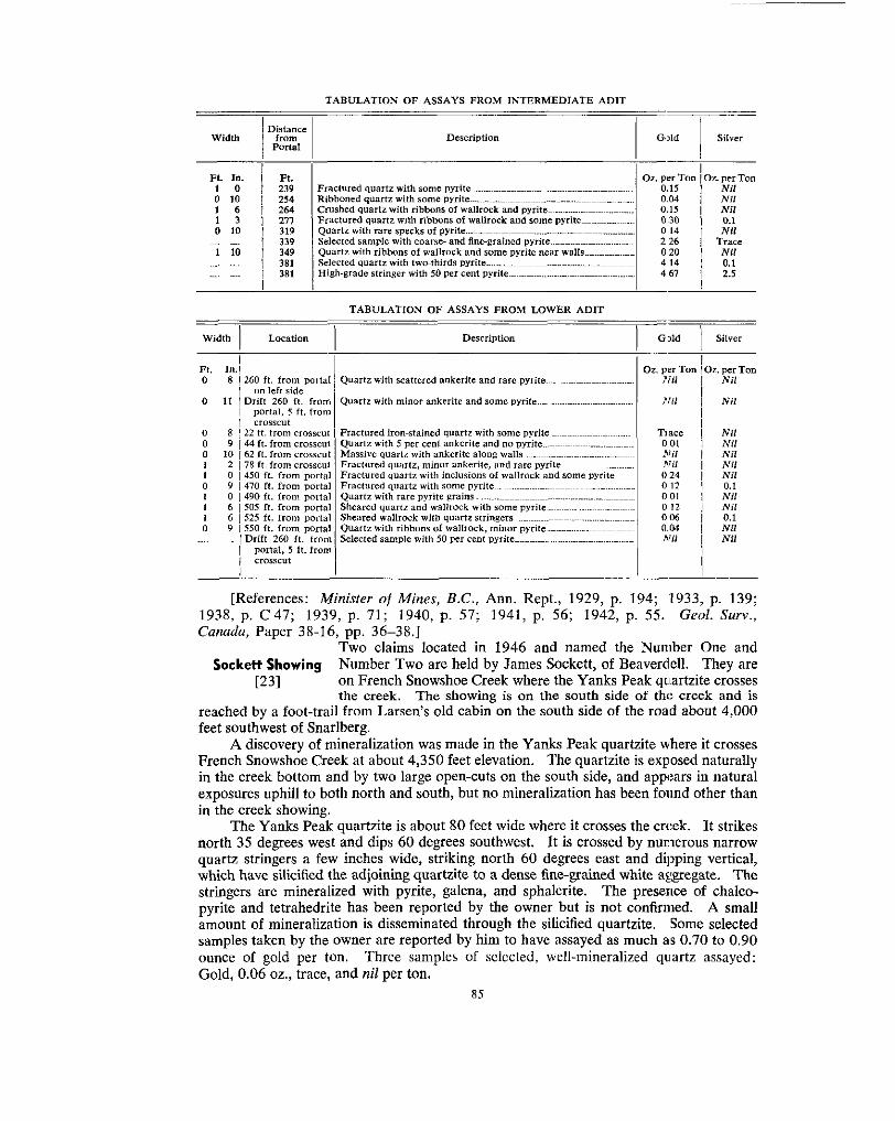
". TABULATION OF ASSAYS FROM INTERMEDIATE ADlT
Description 1 Gllld I Silver
TABULATION OF ASSAYS FROM LOWER ADlT
Width 1 Location Description I G,>ld 1 Silver
~~
Ft. 0
n
0 0 0
0 I
I
Nil Nil Nil Nil Nil 0.1 Nil Nil
Nil 0.1
Nil
1938, p. C 4 7 ; 1939, p. 71; 1940, p. 57; 1941, p. 56; 1942, p. 55. Geol. Surv., [References: Minister of Mines, B.C., Ann. Rept., 1929, p. 194; 1933, p. 139;
Canada, Paper 3R-16, pp. 36-38.] Two claims located in 1946 and named the Number One and
Sockett Showing Number Two are held by James Sockett, of Beaverdell. They are
the creek. The showing is on the south side of the creek and is reached by a foot-trail from Larsen's old cabin on the south side of the road about 4,000 feet southwest of Snarlberg.
French Snowshoe Creek at about 4,350 feet elevation. The quartzite is exposed naturally A discovery of mineralization was made in the Yanks Peak quartzite where it crosses
in the creek bottom and by two large open-cuts on the south side, and appears in natural exposures uphill to both north and south, hut no mineralization has been fonnd other than in the creek showing.
The Yanks Peak quartzite is about 80 feet wide where it crosses the creek. It strikes north 35 degrees west and dips 60 degrees southwest. It is crossed by numerous narrow
which have silicified the adjoining quartzite to a dense fine-grained white aggregate. The quartz stringers a few inches wide, striking north 60 degrees east and dipping vertical,
stringers are mineralized with pyrite, galena, and sphalerite. The presence of chalco- pyrite and tetrahedrite has been reported by the owner but is not confirmed. A small amount of mineralization is disseminated through the silicified quartzite. Some selected samples taken by the owner are reported by him to have assayed as much as 0.70 to 0.90 ounce of gold per ton. Three samples of selccted, well-mineralized quartz assayed: Gold, 0.06 oz., trace, and nil per ton.
t231 on French Snowshoe Creek where the Yanks Peak qllartzite crosses
85

The Stockwork about 5,850 feet, about 3,000 feet north of the Jim adit and about The Stockwork consists of a group of quartz veins at an elevation of
quartzite of the Snowshoe formation and occupy an area about 300 feet square just west Lieut.-Col. F. H. M. Codville, of Duncan. The veins are in grey
of the western contact of a narrow band of Midas black silty quartzite. The vein area is on the western flank of a northeasterly dipping anticlinal septum of Midas rocks.
in rocks striking about north 30 degrees west and dipping gently northeast. Lineation in The veins are exposed in shallow surface workings and natural outcrops, They are
the Midas formation just east of the vein area plunges 15 degrees to the northwest. Quartz veins occupy several sets of fractures. The most prominent fracture direction
north 25 degrees east and due east. Vein quartz parallel to the schistosity of the rocks strikes about north 50 degrees east, and less conspicuous fracture directions strike about
joins the northeasterly striking veins and in so doing tends to form a rather complex pattern. Some of the veins attain a width of 12 feet and several are 3 to 6 feet wide. The amount of quartz in this small area js quite impressive. However, in most exposures the quartz is barren or only sparsely mineralized. One vein near the western side of the area is well mineralized with galena, sphalerite, and pyrite. From it three samples of selected material were taken. One containing galena and no pyrite or sphalerite assayed: Gold, 0.01 oz. per ton; silver, 7.8 02. per ton; and lead, 20.5 per cent. One containing sphal- erite and some pyrite but no galena assayed: Gold, 0.01 oz. per ton; silver, 0.1 02. per ton; and zinc, 1.3 per cent. One containing about 20 per cent pyrite and no galena or sphalerite assayed: Gold, nil.
Canada, Paper 38-16, p. 34.1 [References: Minister of Mines, B.C., Ann. Rept., 1929, p. 195. Geol. Surv.
Scheelite was discovered by B. E. Taylor, of Wells, about 1,000 Taylor Tungsten feet north of the underground workings on the Hebsou vein. The
in grey quartzites of the Snowshoe formation striking north 30 degrees west and dipping gently westward into the head of McMartin Creek. The veins are
clinal septum of Midas black silty quartzite, the Breakneck anticline which encloses the about 45 degrees to the southwest. They are about 700 feet west of the axis of an anti-
Hebson vein. The Snowshoe formation lies in a northwesterly plunging syncline whose axial plane is about 1,500 feet west of the workings.
The workings were examined by Stevenson in 1940 at a time when the trenching had been newly done. The following description is from his report in British Columbia Department of Mines Bulletin No. 10 (Revised), 1943, pages 98 to 100:-
The tungsten occurs in a lenticular quartz-scheelite vein, strike north 60 degrees west and dip 75 degrees south-westward, that ranges in width from 1 inch to 4 inches and is exposed for approximately 18 feet before disappearing into sheared rock. The vein shear cuts fissile quartz- ites and sericite schists that strike in general north 15 degrees west and dip SO degrees south- westward; these rocks comprise part of the Richfield [sic] formation. In the vicinity of the vein-shear the rocks have been impregnated by small amounts of pyrite and galena.
The workings consist of two trenches and in one of them a shaft. Elsewhere two pits have been dug.
Number 1 trench extends north-westerly for 38 feet. I t is 6 to 7 feet wide, 1 to 2 feet deep and towards the middle a shaft 6 feet in diameter and 6 feet deep is sunk.
Number 2 trench, in direction transverse to that of Number I , lies north-westerly from it. The north-east end of Number 2 trench, extending for 35 feet in a south-westerly direction, is 15 feet north from the north-west end of Number 1 . It is 4 feet wide, 6 feet deep at its north- east end and 1 foot deep at its south-west end.
t131 2,800 feet south of the Cornish Ledges. It is on ground held by
P I scheelite showings are at 5,900 feet elevation on ground sloping
Scheelite was seen only in Number 1 trench.
exposure is in the north-west face of the shaft in Number 1 working, where the vein is slightly The vein is a quartz-filled shear that cuts fissile quartzites and sericite schists. Its best
lenticular, ranging from 3 to 4 inches in width and is bordered by Y8 inch of sheared rock. The vein-matter consists of large, poorly-deiined crystals of quartz arranged perpendicularly to the walls of the vein and enclosing patches and crystals of scheelite, its oxidation product tungstite
86

ments. The amount of scheelite is quite variable, ranging in places from a fraction of a per cent and stolzite. A small amount of galena occurs as widely-scattered grains in the adjacent sedi-
to about 50 per cent of the vein-matter. A representative 30-pound sample taken along the full .(.inch width of the vein and over a 4-foot length in the north-west face of the shaft assayed: Tungstic oxide (WOO), 26.2 per cent.
The writer did not see any scheelite in the last 12 feet of the vein but it is reported to have been The scheelite vein extends south-easterly for 18 feet from the north-west side of the shaft.
found when digging the trench. In a north-westerly direction the vein narrows to a barren shear within a few inches of the side of the shaft, and, as such, disappears under the debris that covers the floor of the trench dug along the projected extension of the vein. Numbel 2 trench cuts
not expose any vein-matter or well defined vein-shear. across the projected strike of the vein at a point 30 feet north-westerly from the shaft but does
The vein appears to cut three earlier bedded quartz veins, barren of scheelit,:. One of the bedded veins extends along a bedding plane in the sediments for a distance of 3 feet northerly
vein for 1 foot along bedding planes of the sediments. These bedded veins appear to have been from the scheelite vein, The other two bedded veins extend south-westerly from the scheelite
fed by the fissure now occupied by the scheelite vein. The formation of then: bedded veins would therefore have antedated the deposition of the scheelite in the main vein.
A shallow pit has been dug in the banks of a small south-westerly-flowing creek at a point approximately 570 feet north-westerly from Number 1 pit. This working exposes a small amount of galena which occurs as (1) grains in bedded quartz lenses 1 inch thick and 1 foot to 2 feet in length, and (2) as grains disseminated in fissile quartzite adjacent to the quartz lenses. A low percentage of pyrite and sphalerite is associated with the galena.
exposes a 2-foot length of a quartz lens 1 foot thick that contains pyrite, marcasite, galena and Fourteen feet upstream from the last pit, another working 6 feet in diameter and 5 feet deep
sphalerite.
a general north-westerly direction and dip 10 degrees south-westward. The rocks in these two pits are nearly flat-lying, fissile quartzites that appear to strike in
Since the property was examined by the writer in July, 1940, two new pits have been sunk
the season of 1942 to get under these showings. However, the work has so far failed to disclose 10 feet and 8 feet on the main tungsten showings and it is understood an adit was started late in
additional ore.
The adit referred to was driven 90 feet but did not cross any tungsten-bearing vein.
[Reference: B.C. Dept. of Mines, Bull. No. 10 (Rev.), 1943, pp. 98-:.00.]
Yanks Peak Lots 10662 to 10668. The assessed owner is Cariboo Yankee The Yanks Peak group consists of seven Crown-granted claims,
Bank Building, Vancouver. The claims are on the southwest slope of Yanks Peak and extend in single file from the top of the ridge at 5,800 feet elevation southeastward downhill to French Snowshoe Creek at 4,500 feet elevation.
Yanks Peak, and three claims were located in that year. Three other claims were located Veins were found in 1923 by H. Talbot and J. Larsen on the southwest slope of
in 1924. In 1929 a mill of 25 tons capacity was erected near the camp and near the portal of a low-level adit. The Yanks Peak Mining Company Limited was incorporated in January, 1930, to explore the showings. Little work was done until 1933, by which time the property was being worked by Cariboo Yankee Belle Mining Company Limited. This company began in August, 1933, to drive a crosscut to explore the Corhan vein zone
in 1935. In 1938 the length of the crosscut was increased to 1,643 feet, and :no work has about 350 feet below its outcrop. The crosscut was driven 1,585 feet when work stopped
been done on the property since. The portal is caved and the workings are :inaccessible.
except that the East Yanks Peak NO. 2 (Lot 10668) near French Snowshoe Creek is The Yanks Peak claims are underlain by rocks of the Yankee Belle formation,
crossed by Yanks Peak quartzite and some Midas rocks. On the upper claims near the Corban showings the rocks are dominantly laminated argillaceous silty quartzites, either grey or brownish weathering, and commonly spotted with porphyroblastic ankerite.
The rocks have a prevailing northwesterly strike and occupy the core of the Yankee Belle anticline, a major fold structure whose isoclinal limbs are about 3,500 feet apart. The Yanks Peak claims straddle and lie to the east of the axis of this anticke. Small
87
It was abandoned at that point and no further work has been done.
r211 Belle Mining Company Limited, c/o B. G . Hawkins, 424 Standard

dragfolds indicate that the minor details of folding are extremely complex, probably
peak. The scarcity of exposures and the absence of marker beds make detailed structural comparable to the internal structure of the Midas formation on the ridge northeast of the
mapping very dficult. Several faults which are to he seen on the north face of Yanks Peak (see Plate I1
was observed. When the main crosscut was driven, a large fault was encountered about (A) ) may extend southwest across the claims, but no surface indication of their presence
extension to the north is believed to lie to the east of the surface workings on the Corban 700 feet from the portal. This fault is reported to strike slightly east of north. Its
vein, but no surface expression of it was observed.
Yanks Peak claim (Lot 106621, between 5,575 and 5,725 feet elevation, in an area about The veins for the most part lie in two main groups. The Corban vein zone is on the
500 feet long and 200 feet wide below the old high-level trail to the Midas camp. The Talbot veins are on the Yanks Peak No. 2 claim (Lot 10663) at about 5,700 feet eleva- tion and are about 1,500 feet northwest of the Corban showings.
The main surface showings are veins in the Corban zone. These veins have been exposed in three adits, two shallow shafts, and two open-cuts (see Fig. 14). The adits are caved and the open-cuts partly sloughed so that the veins are not all visible. Actual and inferred positions of the veins indicate that they occupy fractures striking north 50 to 60 degrees east. The zone is believed to lie on the west side of the large fault that was encountered in the long crosscut. Vein quartz as much as 30 inches wide is exposed in some of the workings, and quartz is seen on the dumps of others. The quartz is extremely vuggy and contains numerous large quartz crystals which distinguish it from other vein quartz in the area. Cubical cavities mark the places where pyrite has been weathered from the vein outcrops, and limonitic incrustations in the vugs are common. However,
of only two veins. the amount of pyrite mineralization was small, and visible gold was seen in the outcrops
The three adits appear to have been driven on separate veins. From available surveys their lengths are: Lower adit, 148 feet; middle adit, 182 feet; and upper adit,
are shown on Figure 14. 86 feet. Assays of samples taken in 1950 are tabulated below. The sample locations
ASSAYS OF SAMPLES FROM CORBAN VEIN ZONE ____
$5:; I Width Fig. 14
DeECriYtion 1 Gold 1 Silver
~
I 1 PL. in.
I
I I I 2 6 Brecciated and recemented quartz, Partly YUgSY: Pyrite 3 inches
2 1 2 2 Massive quartz with 5111811 amount of pyrite, small number of vugs.
I Fractured partly vuggy quam, irohwincd, but no visiblc rnineruli- 5 ! 1 6 0.01 1 0.2 Massive partly w g g y quartz, rare pyrite, some limonite ~~~~~ ~~~~~~ ~~.~~~~~~~~~ 4 1 1 4 0.08 I Nil Brecciated recemented quartz. limonite in Cement an6 in vugs ~ ~ . . . . ~ ~ ~ ~ ~ ~ ~ ~ 3 1 2 9 Nil I Nil
h i 1 6 Fractured vueev ~milrtz with limonite as slain5 and in vu- ~~ ~~~~~~~~~~~ ~~ Nil I 0 7
01. per Ton 101. per Tan
wide near one wall: some visible gold present . . . ~ . ~ ~ ~ ~ ~ ~ ~ ~ ~ ~ ~ ~ ~ . . ~ . ~ ~ ~~~~~~ 0.03 1 Trace
zation ~~ ~~~ . ~~~~~~~~~~ ~ ~ ~ ~ . ~ ~ ~ ~ ~ ~ ~ ~ ~ ~ ~ . ~ ~ ~ . ~ ~ ~ ~ ~ ~ ~ ~ ~ ~ ~ ~ ~ ~ ~ . ~ ~ ~ ~ ~ ~ ~ ~ ~ ~ ~ ~ ~ . . ,Mi 1 *Til
claim expose some quartz veins whose attitude is not known. These veins probably are A number of trenches about 200 feet east of the southeast corner of the Yanks Peak
on the east side of the fault encountered underground in the long crosscut. The portal of the long Carihoo Yankee Belle crosscut is 280 feet southeast of the
west corner of the Yanks Peak No. 3 claim (Lot 10664) at 5,301 feet elevation. The
Corban vein zone. The adit is inaccessible, hut a survey made in July, 1935, by C. crosscut has a total length of 1,643 feet and was driven to explore the area below the
88

Beadon, of London, is shown on Figure 14. A large fault zone, presumed to strike about 10 to 20 degrees east of north, was crossed about 700 feet from the portal. The face of the crosscut is about 380 feet vertically below the Corban vein zone. It is reported* that a large number of veins were crossed, striking from north 33 degrees cast to south 80 degrees east and either vertical or dipping steeply southeast. The 1arge:;t was about 6 feet wide and many were less than 1 foot. The highest assays, reported to be about half an ounce of gold per ton, are said to have been obtained from a 15-inch vein about 685 feet from the portal. One of Beadon’s maps indicates that veins 1,510 and 1,512 feet from the portal contained visible gold.
The Talbot showings consist of a number of veins at an elevation of about 5,700 feet in the central part of the Yanks Peak No. 2 claim. The veins are exposed in a shallow shaft and in surface trenches. Most of the veins occupy northeasterly striking fractures. The quartz is extremely vuggy and is sparsely mineralized.
Five samples from the Talbot showings assayed: Gold, nil or trace. Ore of selected pyrite from a vein 100 feet east of the shaft assayed: Gold, 0.55 oz. per ton.
1933, p. 137; 1934, p. C 30; 1938, p. C 48. Geol. Surv., Canada, Paper 38-16, pp. [References: Minister of Mines, B.C., Ann. Rept., 1925, p. 161; 1!>29, p. 192;
40, 41 .I * Geol. S u n . , Conodu, Paper 38~16, p. 41.
89

APPENDICES -
APPENDIX A
SURVEYED LOTS ON FIGURE 2, SHEET A, AND CORRESPONDING CLAIM NAMES 4668. Saddle. 4669. Saddle Extension. 4670. Midas. 4671. Midas Extension No. 2. 4672. E. T. Fraction. 4673. Midas Extension No. 1. 4674. A. T. Fraction. 4675. I. B. Fraction. 4676. Fill Fraction. 4677. West Midas Extension No. 1. 4678. Ridge No. 1. 4679. Ridge No. 2. 4680. Ridge No. 3. 4681. Ridge No. 4.
10662. Yanks Peak. 10663. Yanks Peak No. 2. 10664. Yanks Peak No. 3. 10665. Y. P. Fraction. 10666. East Yanks Peak. 10667. Y. P. E. Fraction.
10668. East Yanks Peak No. 2. 11237. Jim. 11238. Pete. 11331. Jane Extension No. 1. 11332. Bertha. 11333. Indian Broom. 11334. Betty Fraction. 11335. Betty. 11336. Junior Fraction. 11337. Old Timer. 11338. Jane. 11339. Old Faithful. 11340. Little Robert.
11 342. Bella Coola. 11341. Junior.
11 343. Junior Extension. 11 344. Grouse. 11345. Jane Extension No. 2. 11346. Tri Fraction.
SURVEYED LOTS ON FIGURE 2, SHEET B, AND CORRESPONDING CLAIM NAMES
3485. International No. 5. 3486. International No. 6. 3487. International No. 7. 3488. International No. 8 . 3489. International No. 1. 3490. International No. 2. 3491. International No. 3. 3492. International No. 4. 3493. Dawn Fraction. 3494. Dawn No. 2 Fraction. 3495. No. 1 International Fraction, 3497. Sedan No. 3. 3498. Huh No. 2 Fraction. 3499. Peerless No. 3. 3500. Huh Fraction. 3501, Sedan No. 2. 3502. Peerless No. 2. 3503. Sedan No. 1. 3504. Peerless No. 1. 3505. Sedan No. 4 Fraction. 3506. Sedan No. 5 Fraction. 3507. Federal No. 1. 3508. Peerless No. 4 Fraction. 3509. Federal Fraction.
3510. Surprise No. 2. 351 1. Surprise No. 4. 3512. Surprise No. 7 Fraction. 3513. Surprise No. 1. 3514. Surprise No. 3. 5905. Cunningham No. 1. 5906. Cunningham No. 2. 5907. Cunningham No. 3. 5908. Cunningham Extension No. 1. 5909. Cunningham Extension No. 2. 5910. Sidewinder No. 1. 5911. Sidewinder No. 2. 5912. Sidewinder No. 3. 5913. Sidewinder Fraction. 5914. Black Martin No. 2. 5915. Black Martin No. 1.
5917. Black Martin No. 4. 5916. Black Martin No. 3.
5918. Black Martin Fraction. 5920. Roundtop. 5921. Cunningham Fraction. 5922. Tiny Fraction. 9816. Hudson. 9817. Glen Echo.
90
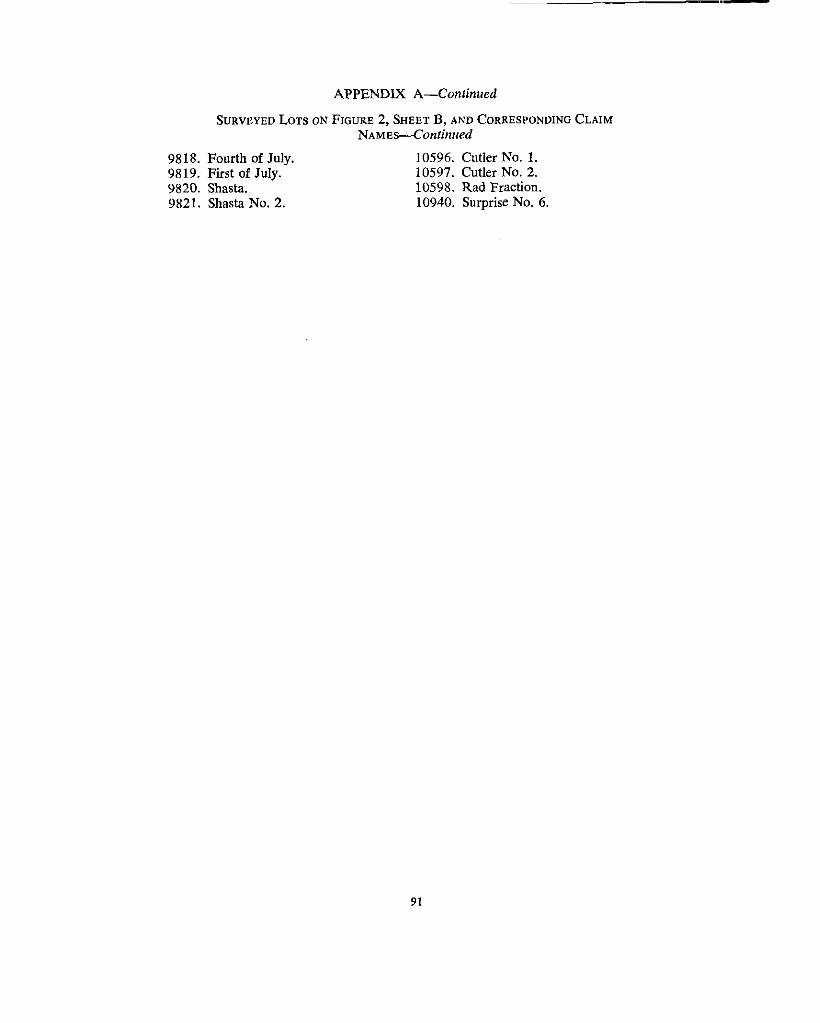
APPENDIX A-Continued
SURVEYED LOTS ON FIGURE 2, SHEET B, AND CORRESPONDING CLAIM NAMES-Continued
9818. Fourth of July.
9820. Shasta. 9819. First of July.
9821. Shasta No. 2.
10596. Cutler No. 1. 10597. Cutler No. 2. 10598. Rad Fraction. 10940. Surprise No. 6 .
91
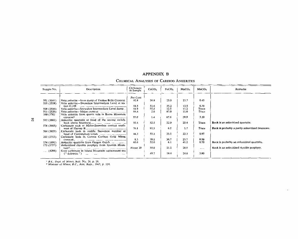
APPENDIX B
CHEMICAL ANALYSES OF CARIBOO ANKERITES
551 (3641) 535 (2539)
509 (2516) 513 (2520) 160 (776)
\o N 512 (3661)
516 (3665)
564 (3653)
262 (2713)
174 (1891) 173 (1757)
(4284)
Per cent 92.8
5R.5 81.9 Y4.4
s5.0
55.4
76.1
44.3
60.6 8.3
About 20
__ __ c a c o j __
50.8
51.6 55.5 2.0
1.4
52.5
92.3
53.3
39.1 52.0
50.0
49.7
25.0
35.2 32.5 87.0
65.6
22.0
6.2
23.5
36.1 6.1
21.2
19.4
23.7
11.2 12.5
11.0
29.9
25.4
1.7
22.3
23.7 41.2
28.8
24.6
Remark
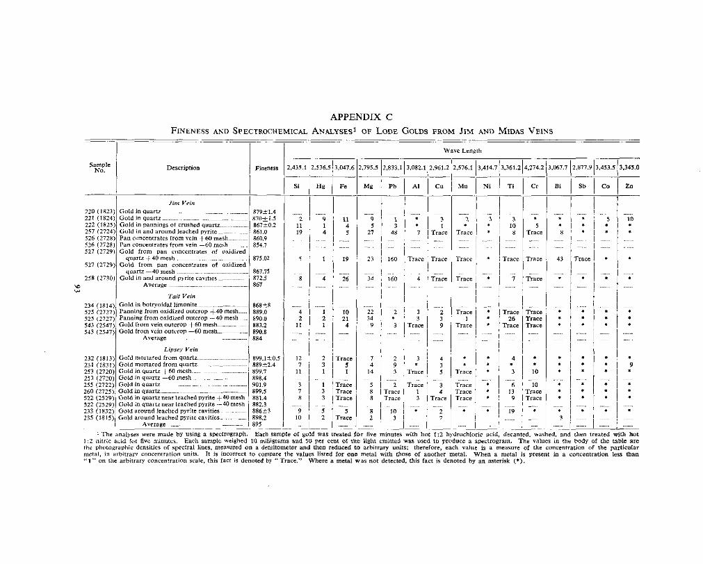
APPENDIX C FINENESS AND SPECTROCHEMICAL ANALYSESi OF LODE GOLDS F R O M JIM AND MIDAS VEINS
Description
86828 889.0 890.0
890.8 883.2
884
rrace 7 ' 2 I
rat EO

APPENDIX C-Continued
FINENESS AND SPECTROCHEMICAL ANALYSES~ OF LODE GOLDS FROM JIM AND MIDAS VEINS-Confinued
I I I Wave Length
Saddle vein 544 (2548)
Gold in quartz with pyrite. galena, and 545 (2549)
Gold in quartz with pyrite and SDhaierite 544 (2546)
Gold in quartz with pyrite and Sphalerite + 4 0 m c s h ~ ~ ~ ~ ~ ~ ~ . ~ . ~ ......
879.6 sphalerite, +60mesh
874.6 - 40 me.h
881.3
A ~ e r a g e 878
252 (2719) 889.42 Gold in honeycomb quanr 2% (2723) 886.01 Gold picked from leached pyrite cavities
Slotion 4 vein
E average^^-^^.^^^.^ ...... ~ ~~~~~~~ 888
,274.2 3.067.7 12.877.!
Bi 1 Sb
I I
1:2 nitric acid for five minutes. Each Sample weighed 10 milligrams and SO per cent of the light emitted was used to produce a spectrogram. The values in the body of the table are 1 The ~ ~ I Y J C S were made by using a spectrograph. Each sample of gold was treated for five minutes with hot 1:2 hydrochloric acid, decanted, washed, and then treated with hot
the photographic densifies of SDCCfml lines, measured on a densitometer and then reduced to arhitrary units; therefore, each value is a measure of the cmcentmtion of the pa'ticular metal. in arbitrary concentration units. I t i s incorrect to camparc the values listed for one metal with those Of another metal. When a metal is present in a Concentration less than " 1 " on the arbitrary concentration scale, this fact i s denoted by "Trace." Wherc a metal was not detected, this fact in denoted b y an asterisk (*).

APPENDIX C d o n t i n u e d
FINENESS AND SPECTROCHEMICAL ANALYSESi OF LODE GOLDS FROM SNOWSHOE AND CORBAN VEINS
Sample NO. Description Fineness

APPENDIX C-Continued
FINENESS AND SPECTROCHEMICAL ANALYSES~ OF LODE GOLDS FROM SNOWSHOE A N D CORBAN V E I N S - C o n t i n u e d
,536.513.047.6 2,795.:
H8 I Fe I- Mg
i i I
Wave Length
1:2 nitric acid far five minutes. Each sample weighed 10 milligram$ and 50 per cent of the light emitted was used to produce a ~ p e ~ f r o g r a m . The value$ in the body of the table are *The ~lnalyse? were made by Usins a rpectrosraph. Each sample of gold was treated for five minutes with hot 1:2 h y d r o ~ h l o r i ~ acid. decanted, washed, and then treated with hot
fhe phologruphi~ densities 01 spectral lines, measured on a dcnsitometer and then reduced to arbitrary Units; therefore, each ?due i s a measure of the Concentration of the particular metal, in vrbilrary concentration units. It is incorrect t o compare the values listed far one melai with those of mother mc131. When a metal is prercnt in a concentration less than '' 1 " on the rrbitrary concentration scale. lhis fact is denoted by "Tracc." Where a metal was not detected, this fact is denoted by an asterisk (*).
a Fineness of sold bead obtained by smelting pyrite.
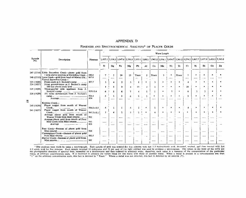
APPENDIX D FINENESS AND SPECTROCHEMICAL ANALYSES~ OF PLACER GOLDS
~- Wave Lenglh
Sample N O . DeSCriptiOll
3.067.7/2,877.9/3.453.513,345.0 2,576.1 13,414,713,361.214.274.2 2,795.5~?,833.1/3,082.1~2,961.2 2,435.112,536.5)3,047.6 Fineness
Si I Hg I Fs Bi 1 Sb I Co 1 Zn M n I Ni 1 Ti I Cr ME I Pb 1 AI Cu
I ~
I 24
2
3
6
3 .""
247 (2714) Little Snowshoe Creek-placer gold from 1 mile aMYc junction Of Snowshoe CreekL 880.0
248 (2715) L u ~ e Creek-gold from head Of Minisci Pit .. 817.6
223 (1826) Fmm creek at I . Socken's s i l m p ~ ~ - ~ ~ ~ - ~ ~ . . ~ ~ 857.7 224 (1827) From ground-slnice at 1. Sockeft's camp
22s (1828) Threequarter mile upstream from J.
French Snowshoe Creek-
1W feet above creek level
Sockett's s m l l 82O-tO
...."
I 1 2
3
226 (1829)l 1% miles dow&eam from J. Sockett's cam0 1 824.4
I 2
I 4 I
3
1
4
4 1
2
5
3
2
2

INDEX
. . ............................. Adams. Jim 48, 51 A T Fraction, Lot 4674 68, 90
Adams Comoanv ................... 48 ..........
~~
Aitkens. D........ ................................................ 11 Allan vein^^^ .......................... - ......................... 71 Allison . Sam ...-....... ............... ~ ~ . ~ ~ . ~ 6 0 . 62 Allison (group) ............................................... 62 Alpha company^^^^^.^^..^^^.^^ ............... ......... 49 Amparo Co . Ltd. ... IO, 20, 29, 64, 68, 71, 73, 75 Anderson, G . ...................... 39 Anderson, W . F . ~ ~ ~ ~ ~ . ~ ~ ~ ~ .................................... 49 Ankerites, chemical analyses of Cariboo
Antler Creekk 1 2. 22 26 anker1te.s 92 ............ ............
........................................ . ...... ~~
Placer ............................ ........ 47, 49 Apps, G . E................................... .................... 1 1 Arrastre adit^^^^^.^^^_^^^.^^^ ............ 8 1 Arrastre ............................. 79 Aster A, triangulation station.. .............. 11, 22, 63 Aster B, triangulation station ..............
Aster Creek 10, 13, 29, 32, 64 ..11, 13, 22, 29, 62, 64, 79 ..................................
...............................
Barr. R o h e r t ~ ~ ~ ........ ..... 48, 49 Barr Creek, placer.^ .............. .... - 52
Placer production ......................................... 53
Beadon, C 89 Base Mountain 10, 12, 14, 15, 22, 27, 30, 31, 32
Bee, triangulation station .......... 11, 17, 18, 21, 27 Bella Coola, Lot 11342~ ............... 90
Bennett, W.............. 49 Benedict, P 25
Bertha, Lot 11332 ............................ 79, 81, 83, 90 Betty, Lot 11335~ SO, 90 Betty Fraction, Lot 11334 .......................... 79, 90 Betty vein^^^^^^^^^^^^^ ........................................ 40, 43 Bibliography .................................................... 11
Black Martin group)^^^^..^^^ 57 Big Valley Creek 14
Black Martin Fraction, Lot 5918 .................. 90 Black Martin No . I , Lot 5915 ........................ 90 Black Martin No . 2, Lot 5914 ........................ 90 Black Martin No . 3, Lot 5916 ........................ 90 Black Martin No . 4, Lot 5917 ....................... 90 Bowman, Am os.................. ..IO, 25, 39, 63, 66, 68 Borland, Robert (see also Veith and Bor-
............................ 9, 48, 55 Bralco cabin ........................... ... 21, 22, 31, 44 Breakneck Ridge ............. 13, 29, 62, 64, 79, 86 Britannia Mining and Smelting Co . Limited
............................................................ 68, 69, 71 Brown, A . Sutherland ............................ 11, 14, 38 Brown . C . E . Gordon .................................... 57
.... . .....
. .............................. ........
.............................................. ...........................
Buschmann. august^^^^ ..................................... 63
Calgary Dam ................................................. 51, 63 Camp adit ....................................... ~ . ~ ~ ~ ~ ~ ~ 7 9 , 81, 82
Carihoo Amalgamated Gold Mines Limited 57 Tabulation of assays f r o m ~ ~ ~ ~ 84
C a r i b Gold Quartz mine ............................ 25 Carihoo-Hudson Gold Mines limited^^^^^.^. ... 57 Carihoo-Hudson Gold Mines (1946) Limited
......................
" "
................................... ." ........ Carihoo Hudson mine^^..^^.^^^^^^^^^^^^^^^^^^^^
57,
Scheelite 49, 10, 14, 38, 39, 42, 44, 57, 60,
vein^^^^ 43,
......... ..............
....................................................
.............................................. Cariboo Keithley Gold Placers Cariboo Mines Ltd ...........................................
......................
11
64 5 1
56 5 1
68
Carihoo mountains^^.^^^^^^^^^^^^^^^^^^^^^^^ ............. 12 Cariboo (North Fork of Quesnel) river^^^^ ........................................................... 14, 26, 47
Carihoo Sentinel, The .......................... 39, 47, 48 Carihoo Thompson (Rand). 76, 77 Carihoo Yankee Belle Mining Company
Limited ...................... 87 Clark. Tom ..................................................... 51 Cleavage ................................ .- ....................... 34 Codville, F . H . M., L i e u t . - C o l . ~ ~ ~ ~ ~ ~ ~ ~ t i 6 , 68, 69, 86 Coniagas adit^^^. .......................................... 76, 77 Contents ...... ................. 3 Copper, in gold^^^^^.^^^^^^^^^.^^^.^.^ ......................... 46 Copper C r e e . ~ ~ ~ . ~ ~ ~ .......................
Comer Creek fault .............................. 3 4. 60 . 71 IO, 12, 13, 21, 23, 31, 34, 42, 46, 57, 76, 17
Prospecting possihilities~~~ 46 Corban ............................ 88
Assays of samples from. ............................ 88 Fineness and spectrochemical antilyses of
S h o w i n g s ~ ~ ~ ~ ~ ~ ~ ~ ~ ~ ~ ~ ~ ~ ~ ~ ~ ~ ~ ~ ~ ~ ~ ~ ~ ~ . ~ ..L19, 40, 43, 44 lode golds f r o m ~ ~ ~ ~ ~ ~ ~ ~ ~ ~ ~ ~ ~ ~ 45, 96
Cornish Ledges ... 12, 24, 32, 40, 43, 14, 60, 62, 86 Crazy Creek ......................................... 10, 12, 51
Crystal 66 Placer 50, 56
Cunningham, William .................................. 49 Cunningham c group)^^^^..^ .......................... 57 Cunningham anticline^^^^^^^^^^^^^^^^^^^^^^^
~ 27, 3 1 , 32 Cunningham company^^^^^^^^^^^^^.^ .................... 49
.. . . ...........................
........................
.......
.........................................................
...........................................................
.. Cunningham Creek ..........................................
~~ ~ ~ . 1 0 , 12, 13, 22, 26, 31, 39, 43, 50, 60, 63
Placer production 53 ............................... Placer .38, 45, 47, 49, 51, 5 2
......................................... Cunningham Extension No . 1, Lot 5 9 0 8 ~ ~ ~ ~ ~ ~ ~ ~
..........................................................
Cunningham Extension No . 2, Lot 5 9 0 9 ~ ~ ~ ~ ~ ~ ~ ~ 90 76, 77, 90
Cunningham limestone^^^^^ 16 Cunningham Fraction, Lot 5921 90
Cunningham No. 1, Lot 5 9 0 5 ~ ~ ~ ~ ~ ~ ~ ~ ~ ~ ~~~~~~.~ .39, 90
....................
.............................
Cunningham No. 2, Lot 5 9 0 6 ~ ~ ~ - ~ ~ ~ ~ ~ ~ ~ ~ ~ ~ ~ ..... 90 Cunningham No . 3, Lot 5907 ....................... 90 Cunningham Pass Creek .............................. 49
Cutler (group) 57 Cunningham S., triangulation s t a t io~ l~~~ . l I , 17, 31
Cutler No . 1 , Lot 10596 .................. 1.4, 59, 60, 91 Cutler No. 2, Lot 1 0 5 9 7 ~ ~ ~ ~ ~ ~ ~ ~ ~ ~ ~ ~ ~ ~ ~ ~ ~ ~ ~ ~ ~ ~ ~ ~ ~~~~~~ 91
Davies, Rees ................................................. 39 Dawn Fraction, Lot 3493 ......................... 23, 90 Dawn No . 2 Fraction, Lot 3 4 9 4 . ~ ~ ~ . ~ ~~~~~~~~ ~ 64, 90
................................................
Douglas company^^^^ ....................................... 38 Douglas vein ............................. 38, .19, 47, 79, 81 Dutchman creek^^^^^^^^^^^^^^^.^^^. ..................... 51, 64
E.T. Fraction, Lot 4672 ................................ 90
Economic geology 38 East Yanks Peak No 2, Lot 10668 87, 90
Edberg, P ...................................................... 51
Faults .......................................................... 26, 33 Prospecting possibilities ............................ 46
Federal Fraction, Lot 3509 .... ......... 90 Federal No . I , Lot 3507 .................................. 90 Fill Fraction, Lot 4676 ................................... 90 Fineness and spectrochemical analyses of
Placer golds ................................................ 97
East Yanks Peak, Lot 10666 ......................... 90 . ..............
................................... ....
golds ........................................................ 45, 93
99

PADB Fint of July. Lot 9 8 1 9 ~ ~ ~ . ~ ~ ~ ~ ~ ~ ~ ~ ~ ~ ~ ~ ~ ~ ~ ~ ~ ~ ~ ~ ~ ~ ~ ~ ~ ~ ~ ~ . ~ 5 7 , 91 Folds ........................................................... 25, 27 Formations. Table o f ~ L ................................ 16 Fourth of luly, Lot 9 8 1 8 ~ ~ ~ ~ ~ ~ ~ ~ ~ ~ ~ . ~ ~ ~ ~ ~ ~ ~ ~ ~ ~ ~ ~ ~ ~ ~ ~ ~ ~ 5 7 , 91 Fraser Plateau ................................................. 12 French Snowshoe, triangulation station ...... 11, 22 French Snowshoe
~~~ ~~~~~~~ 9, 10, 12, 13, 17, 21, 23, 27, 30, 32, 33, . 39, 41, 60, 63, 64, 66, 67, 69, 75, 85 Chromum ................................................... 46 placer^^^^.^^^^^^^^^. ................ 45, 50, 51, 52, 55, 56 Placer production ....................................... 53 Prospecting p o s s i b i l i t i e s ~ ~ ~ ~ ~ ~ ~ ~ ~ . ~ ~ ~ ~ ~ ~ ~ ~ ~ ~ ~ ~ ~ ~ ~ ~ ~ ~ ~ ~ ~ 46
Galena Ledge ........................................ 68, 71, 73 Gallagher. B . ~ ~ ~ ~ ~ ~ ~ .................................... 39 Garfield & Company .................................... 48 Glen Echo . Lot 9817 .................................... 5 7. 90
~~~~~ ~, Glover. 69 Gold mineralization. age of^^^^^^^^^.^^^^^^^^^^^^^^^^^. 44
Distribution of^^^.^^^^^^^^^^^^^^^^^^^^.^^^^^^^^^^^^^^^^^^^^^ 44
Gorrie P 75 Golden Gate company^ 48
Graha6, Mr ............................................... 49, 50
Grotto company^^ .......................................... 47 Grouse, Lot 1 1 3 4 4 ~ . ~ ~ ~ ~ ~ ~ ~ ~ ~ ~ ~ ~ ~ ~ ~ ~ ................... 90
................................. . ...........................................
Griffin, J . w... .............................................. 49
Hanson. G. ............................ ~ ~ ~ ~ ~ ~ ~ ~ ~ ~ . ~ ~ ~ ~ ~ ~ ~ ~ I O , 25 Harvey A. triangulation station.^^^^^^ ............
Harvey B, triangulation station ..11, 22, 24 ~ ~ ~ ~ ~ ~ ~ ~ ~ ~ ~ ~ ~ ~ ~ ~ ~ ~ ~ ~ ~ . ~ ~ 1 1 , 12. 15. 24. 30. 31. 32
Harvey Creek ............................. 12. 33. 38. 50 Placer ........................................................ 52. 56
............
. .. Hascltine. William 47
Placer production^^^^^^^^^^^^^^^^^^^^^^^^^ 53
Hawkins, B . G . ~ ~ ~ . ~ ~ ..... ~ ................................... 87 Haywood, tho mas^..^^^ .....................................
Haywood (placer c lam) ............................. 49 Haywood c a b i n ~ ~ ~ ~ ~ ~ ~ ~ ~ ~ ~ ~ ~ ~ ~ ~ ~ ~ ~ ~ ~ ~ ~ ~ ~ ~ ~ . ~ ~ ~ ~ ~ ~ ~ ~ ~ ~ ~ ~ ~ ~ ~ ~ . ~ l O , 50
Hebsan cabin IC Haywood vein (see also Douglas vein)^^^^^^.. 79
Hebson (group) ... ......................... 62 Hebson vein ... 10, 27, 28, 39, 40, 43, 44, 62, 86
...........................................
....................... 38, 39, 47, 48, 49, 50, 52, 79, 81
Hibernian ..................................................... 42, 63 Holmes, Wlll~am 39 Holmes basin^^^^^^^..^^...^^ ....... ~ ~ . ~ ~ . ~ 1 3 , 22, 23, 29, 63 Holmec k d e e ............................................... 39 . 63
. . .............................................
......... Holyk. W........ 11 Homestake ~~~~~~~~~~~~~~~~~ .................................. 63, 64
~~ ~
..................................................
Horseshoe G u l c h ~ ~ ~ ~ ~ . ~ ~ ~ ~ ~ ~ ~ ~ ~ ~ ~ ~ ~ ~ ~ ~ ~ ~ . ~ ~ ~ ~ ~ ~ ~ ~ ~ ~ . ~ ~ ~ ~ ~ ~ ~ ~ ~ ~ 6f Horseshoe Nail Gulch~~. l3 , 15. 20. 23. 30. 32. 6f House Joe ..................................................... 45 Huh iraction, Lot 9C Hub No . 2 Fraction, Lot 3498 ...................... 9( Hudson, Lot 9816 ......................................... 57, 9( Hndwn ( ~ o u o ) ............................................. 57 ........ _ O ~ ~ . . Hudson vein 5E
I.B. Fraction. Lot 4 6 7 5 ~ ~ ~ ~ ~ ~ ~ ~ ~ ~ ~ ~ ~ . ~ ~ ~ ~ ~ ~ ~ ~ ~ ~ ~ ~ ~ ~ ~ ~ ~ ~ ~ ~ 9( Imperial vein 43. 44. 6d Indian Broom. Lot 11333 ........................ 79. 83. 9( Intermediate 80 . 8; ......... . . .
Tabulation of assays from ......................... 81 International p group)^...^^ ................................ 62 International No. 1, Lot 3489~ ....................... 9( International No . 2, Lot 3 4 9 0 ~ ~ ...................... 9( International No . 3, Lot 3 4 9 1 ~ ~ . ~ ~ ~ ~ ~ ~ ~ ~ ~ ~ ~ ~ ~ ~ ~ ~ ~ ~ ~ ~ ~ 9( International No . 4, Lot 3492 ........................ 9( International No . 5, Lot 9(
PAOE
'nternational No . 6. Lot 3486 ....................... 90 'nternational No . 7. Lot 3487 . ......... 90 'nternational No . 8, Lot 3 4 8 8 ~ . ~ ~ ~ ~ ~ ~ ~ ~ ~ ~ ~ ~ ~ ~ ~ ~ ~ ~ ~ ~ 6 4 , 90 ntroduction ............................................ 9 ntrusive racks ........................... _ 23 sland mountain^^^^.^^^^^^^^^^^^^^ ... 14, 25 'sland Mountain Mines Company Limited..76, 79
lane, Lot 11338 ..................................... 79, 81, 90 lane 79 lane Extension No . 1, Lot 11331~ ................ 90 lane Extension No . 2, Lot 11345 .................. 90 'awbone F h - ~ ~ ~ . ~ . ........................................ 49 leffrey, E d w a r d ~ ~ ~ ~ ........ ..38, 39, 79 lews hollow^^^^^^^^ ~ ~ . ~ ~ ~ ~ ~ ~ ~ . ~ ~ ~ ~ ~ . ~ ~ ~ ~ ~ ~ ~ ~ ~ ~ 1 2 , 15, 20, 29 lews Hollow fault .................................. 28, 29, 33 lim, 1.ot 11237 ..................... 12, 40, 44, 45, 66, 90 lim adit 75, 86
Assays of samples from ............................. 68 lim (group) ..................................................... 78 lim syncline ................................ 27, 30, 32, 35, 36 lim vein .......... ............................. 43
Fineness and spectrochemical analyses of lode golds from ................. 93
lohnson, ............................................. 39 Sampling an surface of^ 67 ..............................
........... lohnston. W . A ............................... ~~~~~~~~~~~ 5 1 loints and fractures ................................... 35 lorcenson . D a n ~ ~ ~ ~ ~ ~ ~ . ~ ~ ~ ~ ........................... 46. 77 . 78 . lunior. Lot .......... ..79, 90 lunior Extension, Lot 11343 .......................... 90 lunior Fraction, Lot 11336 .......................... 19, 90
Keithley, W . R . ( D o F ) ~ ~ ~ - ............................... 47 Keithley Creek ............... 9, IO, 12, 23, 39, 50, 79
History of^^^^^^^^^^^^.^^^^ 47 Fineness of gold 45
P l a c e r ~ ~ ~ ~ ~ ~ ~ ~ ~ ~ ~ . ~ ~ ~ ~ ~ ~ ~ ~ ~ ~ ~ ~ ~ ~ ~ ~ ~ ~ ~ ~ 3 8 , 45, 50, 52, 55, 56 Placer production ...................................... 53
Kimball, Mr 48 Prospecting possibilities 46
Kimball C.reek ............................................. 14 Knaebel, I . B ............................................... 75
Lang, A . H: . .IO, 14, 18, 19, 22, 23, 25, 26, 57, 76 Langley adlt ..................... ......... 77 Larsen, John (Jack) ................................ 51, 85, 87 Last Chance company^^^ ................................. 48 Lay, D........... ......................................... 57, 69, 83
............................
...................................
.............................. ..................................................
Lewistown .... 49 Lightning Creek, placer .................................. 47 Lineation ............................................. 36 Little Robert, Lot 11340 ...... ................... 79, 90 Little Snowshoe (Snowshoe) creek^^^^^^^^^^^^^^
~~ ~~~ ..9, 10, 12, 13, 21, 23, 29, 33, 39, 62, 63 Fineness of gold .......................................... 45 History of^^^^^.^^^^^.^^^. ................................... 47 P l a c e r ~ ~ ~ ~ ~ ~ ~ ~ ~ ~ ~ ~ ~ ~ ~ ~ ~ ~ ~ . ~ ~ ~ ~ 3 8 , 45, 49, 50, 51, 52, 55 Placer production ......................... 53
Little Snowshoe Mountain ......... 39 Lipsey vein ... 20, 40, 42, 43, 44, 45, 68, 69, 71, 72
Fineness of gold ...................... 45 Fineness and spectrochemical analyses of
Lode.mining, early history of 38 lode golds f r o m ~ ~ ~ ~ ~ . ~ ~ ~ ~ 93
Lode properties, descriptions 57
Lostway fault^^^^^.^^^ ~~~~~~~~~~~~~ 34 Lostway Creek 10, 12, 13, 18, 23, 34
Louvelette (group) ..................... - .................. 62 Lower ................. 79, 81
Tabulation of assays from .......................... 85
.............................. ........................
... ..........
100

PAGB
Lower Arrastre adit ......................................... 39 Luce. William ........ 39. 47. 48. 49. SO. 52. 79. 81 Luce. Lot 3e .............. ... 48, 49, 50 Luce CreekLlZ, 13, 20, 21, 23, 38, 47, 68, 78, 83
Placer ........................................... .38, 45, 50, 55
McCartney. W . D . ~ ~ ~ ....................................... 11
McGovern. Pat 51 Macdonald, Colin H 57
Martinson, K 51 McMartin creek^^^^^.^^..^ 39, 86
Mason, E . E . ~ ~ ~ ~ ............................................. 57
Matte (group) 62 Matte, Hen ry... 60, 62
Mercury, in gold^^^^^ ........................................ 46 Metamorphism and rock alternation^^^^^^^^^_^^. 24
Midas (group)L ~ ~ . ~ 1 7 , 68 Midas, Lot 4670 ~ ~ ~ . ~ ~ ~ 1 2 , 40, 43, 45, 68, 78, 90
Midas adit.^^^^.^^^ ............................................. 33, 73
Midas Camp 10, 21, 88 Samples from. 75
Midas Extension No . 1, Lot 4673 .............. 68, 90
Midas fault^^^.^^.^^^^^^^^^^^ 29 Midas Extension No 2, Lot 4671L ..64, 68, 90
Midas formation ..... ............................... i 9 Stratigraphy of^^^^^ ................................. 20
Midas vein ........................................... 30, 71, 72 Fineness and spectrochemical analyses of
Middle, triangulation station^^^^^^.^..^^^^^^^^^^^^^..^ lode golds from 93
Mimscr, V . ~ ~ 49, 50 I!, !2 . 16, 17, 18, 19, 21, 27, 30, 31, 33, 34
Mitchell, tom^^^^^ ............................................ 51 Monckton, K . C . F........ ................................... 56 Moneta ............. ~~~~~ ........................................ 57 Monte Christo Company .............................. 39, 64 Moore, I . E ................................................... 57
...................................... .
McCregor, C . A.............. ................................. 11 .................................
....................................................
............................................. ..................................................
... ........................................
..............................................
.....
. ..... ........ ..............
......................................
...............................................
Naylor & Campany .......................................... 48 Newell camp any^^^^^.^.^.^ ............................... 48 Nolaka C r e e k ~ ~ ~ ~ ~ ~ ~ ~ ~ ~ ~ ~ ~ ~ ~ . l O , 12, 13, 19. 21. 33. 34 Nugget ....................... 22
No . 1 International Fraction. ~~~ ~ ~ ~~~~~~
Number Two ..................................................
O'Grady. B . T. ............................................... 81 Old Faithful, Lot 11339 ............................. 90 Old Timer, Lot 11337 ................ 38, 79, 81, 83, 90
Palmer Bench ............................................... 31, 45 Placer ........................................................ 49, 51
Par ............................................................. 76 Pauline vein ~~~~~~~~~ ..................................... 40, 43 Pearce, S ...................................................... 49, 51 Pearce gulch^^^^ .............................................
Placer 4 5. 49 56 .. ~~~~~~~~.~ ~~ 10, 12, 22, 23, 28, 30, 31, 32, 34, 57
................................... ..... . Peerless :
. ~~~ ~ ~, Peter GulchL ............................................ 10,
Placer 45, 51 , 56 12, 28, 30, 31, 34, 39, 43, 44, 59, 63, 76, 77
Petenen, Charles 5 1 Scheelite 57, 59
.................................................
................................................... ............................................
101
No . 1. Lot 3504 ............................... 90 Lot 3502 ................................ 90 .. ~
. .
Peerless iuo . L . Peerless No . 3. Lot 3499 ............ - ........ 64, 90 Peerless No. 4 Fraction. Lot 3508L .............. 90
Pete Lot 1 1238 66 90 Penny 4, 5, 6, 7 Fractions 76 ..............................
. ........................................... .
Pickering. 0 . J . ~ ~ ~ ~ ~ ~ ~ ~ ~ . ~ ~ ~ ................................ 68. 69 Pioneer Gold Mines of B.C. Limited ..79. 81. 82 placer ........................................................ 3 8. 50
Description of properties 56 History of ................................................... 47 Production ............................................... 52, 53 Relation of deposits to bedrock geology~~~~ 5 5
Plateau d '0r ............................................... 33 Plateau d'Or vein ................................... 40, 43, 75 Poole, W . H ............................................... 11 Prospecting possibilities ............................... 46
Quartz comb^^^^^.^ .......... 31, 39 Quartz veins, distribution of^^^^^^^^^..^^. ~~~~~~~~~~ 43
General characteristics of^^^^^^^^^^^^..^^^^^^^^^^^. 40
Rad Fraction, Lot 10598.. ............................ 91 Rand . See Cariboo Thompson . Rawley Company 48, 52 Rawley, J 48
Rawley shaft ........................................... ..48, 50 Reinhnld, R ........................................ .39, 79, 83 Richmond, A . M ........................................... 57 Ridge No . 1 , Lot 4678 .................................. 90 Ridge No . 2, Lot 4679 .................................. 90 Ridge No . 3, Lot 4680 ............................... 90 Ridge No . 4, Lot 4681 ................................. 66, 90
Robertson, Mr 48 Rising Sun company^^^^^^^..^^^^^^^.^ 39
Rose, R . R .................................................... 57 Roundtop, Lot 5920 ....................................... 90 Roundtop, triangulation station .. ...... 11 Roundtop Mountain ............................. 9, 10 .
12, 13, 14, 16, 17, 18, 19, 21, 23, 25, 26, 27, 32, 33, 34, 38, 39, 43, 44, 4!,, 46, 50, 52
Saddle, Lot 4668 ........................................... .68, 90 Saddle Extension, Lot 4669 .................... 68, 69, 90 Saddle Mines L t d . ~ ~ ....... ..... 68 Saddle shaft.^^. .......................... 15, 19, 34, 69, 71 Saddle vein .................. 33, 40, 42, 43, 44, 68, 69
Fineness of gold^^^^^^ ..... 45 Fineness and spectrochemical analyses of lode golds from ........................... -. .............. 94 Samples from ......................... ................. 71
.. ............................
.................................................... .........................................
...................
..............................................
Scheelite, at Peter Gulch (Caribw Hudson) ..................................... ........ At Homestake ............. ~~~~ .......................... 64
49, 51, 57
At Taylor Tunarten .................................. 86 . Scott. N ....................................................... 60, 62 Scott group)^^^..^^^^^^^^^ ..................................... 62 Scott No . 5 ................... .................... 60 Sehastopol Point ............................ 47 Sedan (group) ......................................... 42 Sedan No . 1, Lot 3503 ............. 90 Sedan No . 2, Lot 3501 ................................... 90 Sedan No . 3, Lot 3497 .............. 90 Sedan No . 4 Fraction, Lot 3505 .................. 90
Sedimentary rocks 16 Sedan No 5 Fraction, Lot 3506 90
Sevcwright, T .............................................. 49 Sharp's Bench ........... .. 39
Shata, Lot 9820 57, 91 Placer .49, so, 51, 55
Shasta No . 2, Lot 9821 ............ ..22, 30, 31, 57, 91 Shasta shear ..................... ........................... 58 Sidewinder Fraction, Lot 5913 ...................... 90 Sidewinder No . I , Lot 5 9 1 L ....................... 90 Sidewinder No . 2, Lot 5911 ............................ 90 Sidewinder No . 3, Lot 5912 ..... 90
. ........ ........ ... ..
......................................... ...........................................

Simlock Creek .............. IO, 12, 21. 23. 33, 52. 57 Simlock fault^^^^^^^^^^ .......... 33, 34, 56 Six Mile creek^^^^^^^^^ - ..................................... 39 Sixbee Creek ................................... 10 . 12 . 19 . 31 ~~ ~~~~ ~ . . . Skarn Nos . 1 and Z............ ...................... 42, 43. 77 Skerl. A . C . ~ ~ ~ ~ ~ ~ ~ ~ ~ ~ ~ ......... .................... 25 Slide Company ............................................... 47 Slim vein.^^^^^^^^^^^^^^^ ................. 69, 71, 72
snarl berg.^^^ 10, 17, 20, 30, 63, 68 Smith and Anderson.. 49, 50
Snowshoe Camp ............................................ 10, 20 Snowshoe Creek . See Little Snowshoe Creek . Snowshoe Creek, Keithley Creek, placer .... 52, 56
Snowshoe formation 22 Placer production 53
Snowshoe Gold Mines L imi t ed~~~~ .~39 , 78, 79, 81 Snowshoe mine ........................ 12, 33, 40, 44, 45
........................
.......... ...
....... ..............
Tabulation of assays from surface work- mgs ......................................... ..
Snowshoe Plateau ........................... 10, 12, 22, Snowshoe syncline^^^^^^^^^ ....... 27, 30, 31. 44. 57. Snowshoe vein ............................................. 40.
Fineness and saectrochemical analvses of ~ ~~~~~ ~1 ~~ ~
lode golds from ....................................... Sockett, J . ~ ~ ~ ~ ..... ~ ~ . ~ ~ ~ ~ 1 7 , 23, 33. 43. 46. 51. 69. Somen. MI .................................................... Spectrochemical analyses and fineness of
Standish Company Station 4 vein ..................................................
Fineness of gold ..
Suectrcchernical analyses of lode ~ o l d s
.................................................. golds 4 5 . ..........................................
84 43 59 44
95 85 48
49 93
72 45
.................... .......................
Steele. H W. 39 from 94
Steele and Cunningham tunnel ................... 39, 63 Steele ledge^^^^^^^^^^^^^ - .................................. 68, 71 Stevenson, J . S........................ ... 59, 76, 77, 78, 86 Stockwork, The ............................... 24, 40, 44, 86 Stonewall Company ........................................ 48 Strain, James .............. 48 Strain (lease) ................................................ 49 Structural features, age of^^..^^^^ ...................... 37
Interpretation of ............... ........... 26 Stratigraphic use of^^^.^^ ..................... .- ........ 14
Summary - ". 7 Structural geology.. 25, 27
Surprise No . 1, Lot 3 5 1 3 ~ ~ ~ ~ ~ ~ ~ ~ " ~ 90 Surprise No . 2, Lot 3510 .......... 90 Surprise No . 3, Lot 3 5 1 4 ~ ~ ~ ~ ~ ~ ........................ 90 Surprise No . 4, Lot 3511 .......................... .- 90 Surprise No . 6, Lot 10940 91 Surprise No . 7 Fraction, Lot 3 5 1 2 ~ ~ ~ ~ ~ . ~ ~ ~ ~ ...... 90 Swift River ...................................................... 39
. ...................................................
...............................
................... ................. ........
Tait vein^^^^^^^^^^ ........ ........ 68, 69, 71. 72 PAOB
Fineness and spectrochemical analyses of Fineness of gold 45
Talbot, ................................ 43, 87 lode golds f r o m ~ ~ ~ ~ ~ ~ 93
Talbot ve in^^..^^....^^^^^.^.^^^^^^^^^^^^^.^^^^^^........ 39, 88, 89 Taylor, B . E....... ........................ ......... 62, 63, 86
........................................
......... ..................
Taylor adit .................................................... 63 Taylor Tungsten.. ................................. 42, 43, 86 Thompson. W . E . ~ ~ ~ ~ ~ ~ ~ ~ ~ ~ .............................. 46, 77 Tiny Fraction, Lot 5 9 2 2 ~ ~ ~ ~ ~ ~ ~ ~ " ~ ....................... 90 Treeillus . Fred ................................................ 49 Trehouse Bench. placer^^^^^^^^^^^^^^^^^^ 51 Trehouse Placer .......................................... 49 Tri Fraction, Lot 1 1 3 4 6 ~ ~ " ~ ~ ........................... 90
Uglow, W . L .................................. I O , 14, 17, 25 Uneven Fraction ............................................ 76
Veith, George (see also Veith and Borland)
" . ................
................................................................. 48, 49 Veith and Borland .................... 39, 49, 50, 55, 79 Vein fractures, geologic distribution of.......^^^ 43
Origin of ~~~~~~~~~~~~~~~~ ...... 42 Vein mineralization ........................................ 40 Victoria Company .......................................... 49
Walton, Jack ............................................... 5 1 Weaver. George W ......................................... 47 Weaver Creek, placer^^^-^.^.^ ............................ 47 Wells . F . M . ~ ~ ~ ~ ~ ~ ........................... 3 9. 62 . 79 . 81 . . . Wendle. Elizabeth .................. 76 Wendle. Joseph .............................................. 76 Wendle (group') ............................................ 76 West Midas Extension No . 1, Lot 4677 ...... 68. 90 Williams Creek. placer^^^^^^.^^^ .............. 47 Willow river^^^^^^^^.. .......................... 14, 26 Wylie, J . W . ~ ~ ~ ~ ~ ~ ~ ............................................ 57
Y.P. Fraction. Lot 1 0 6 6 5 ~ ~ ~ ~ ~ . ~ ~ ~ ~ ~ ~ ~ ~ ~ ~ ~ ~ ~ ~ ~ ~ ~ . ~ ~ ~ ~ ~ ~ ~ . Y.P.E. Fraction, Lot 10667 ............................ Yankee belle^^^^^^^.^^ ...................................... 12, Yankee Belle adit^^^_^ .................................... Yankee Belle anticline^^^.^^^^ ........... .27, 28, 69, Yankee Belle camp .................... ...... IO, Yankee Belle formation^^^^^^^^^^^^^.^^ .................. Yanks, triangulation station^ ....... Yanks peak^ .... 9, 10, 12, 13, 14, 16, 17, 18,
19, 20, 21, 24, 25, 26, 27, 28, 29, 30, 32, 33, 38, 43, 44, 45, 46, 50, 52, 65, 69,
Yanks Peak (group) ............................ ~~~~~~~~
Yanks Peak, Lot 10662 ................................ 88, Yanks Peak Mining Company Limited .. Yanks Peak No. 2, Lot 10663 .............. 88, 89, Yanks Peak No . 3, Lot 10664 ......... ......... 88, Yanks Peak quartzite ....................................
90 90 41
87 17
17 17 11
87
90 87
90 87
90 18
Printed by Dolr McDma~m. Printer to rhe Queen's Most Excellent Majem VICTORIA. B.C.
19s4
102

PLATE 1
(A) View eastward from Harvey A down Harvey Creek and up Little Rivstr to the high Cariboo Mountains in the distance (photo by Topographic Division of Department of Lands and Forests).
of the Swift River to the sky-line of monotonously timbered summits of the Interior (B) View northwestward from Yanks Peak across Little Snowshoe Creek and t l e head
Plateau (photo by Topographic Division of Department of Lands and Forests).

PLATE 11
steeply, right-dipping gullies, the two at the left filled with snow and the two beneath the ( A ) Yanks Peak as seen from the camp of Snowshoe Cold Mines Limited. Four
peak in shadow, mark the traces of faults. The Jews Hollow fault is the one at extreme left.
( B ) Camp buildings and mine dumps of Snowshoe Gold Mines Limited at the head of Luce Creek as seen from Yanks Peak.

PLATE 111
. . .
of French Snowshoe Creek lo Base Mountain and Roundtap Mountain in left distance. (A) Looking northeast from Yanks Peak across the Snowshoe Plateau and the head
The Cariboo Mountains are on the distant sky-line (photo by Topographic Dlvision of Departmcnt of Lands and Forests).
ningham Creek and ZCIOSS the Snowshoe Plateau to Yanks Peak in the left distmce and ( B j Looking southwest from Roundtop Mountain up thc valley of the head of Cun-
Cariboo Mountain i n the right distance.

PLATE IV
dipping beds are truncated by almost horizontal cross-beds. The steep right-dipping axial (A) Cross-bedding on a vertical face in Midas silty quartzite. The gentle right-
plane cleavage (parallel to the pencil) indicates that the crest of an anticline lies to the left.
Snowshoe Creek. The hammer-handle is in the axial plane of the fold, and the plunge ( B ) The keel of an overturned syncline in Snowshoe formation at the head of Little
of the fold i s about 20 degrees into the picture.
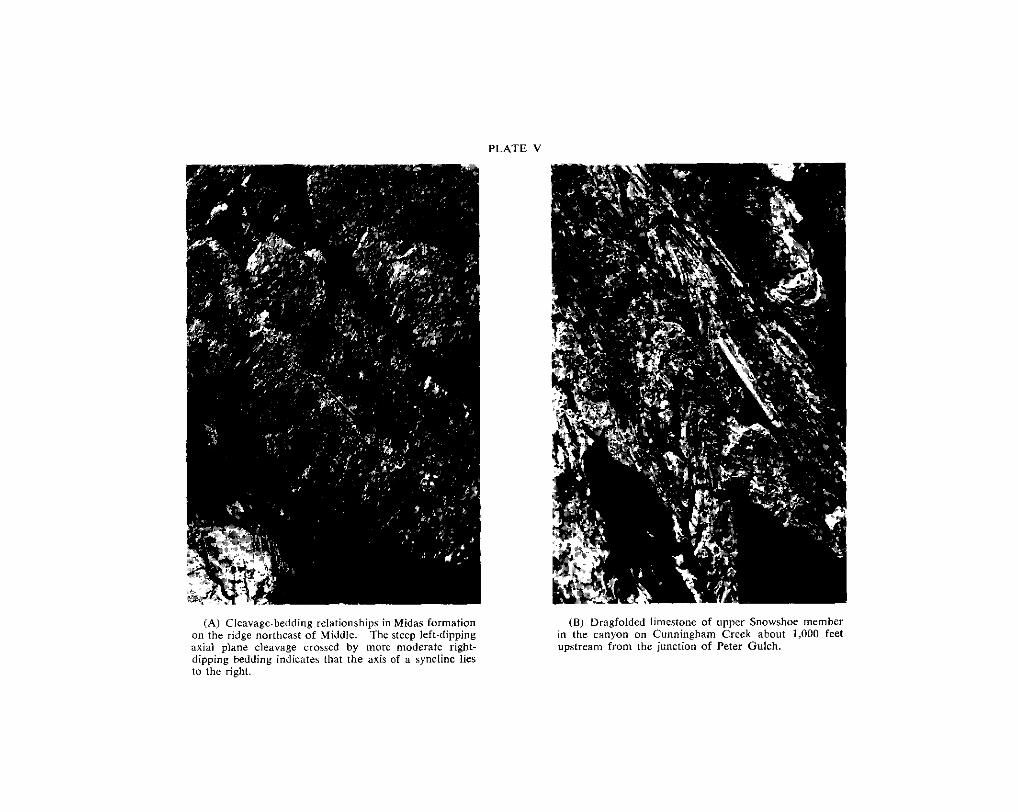
PLATE V
(A) Cleavage-bedding relationships in Midas formation on the ridge northeast of Middle. The steep left-dipping axial plane cleavage crossed by more moderate right- dipping bedding indicates that the axis of a syncline lies lo the right.
in the canyon on Cunningham Creek about 1,000 feet (6) Dragfolded limestone of upper Snowshoe member
upstream from the junction of Peter Gulch.

PLATE VI
of Luce Creek. The pebbles are squeezed and their (A) Basal Snowshoe conglomerate on the ridge north
long dimensions lie in a steep left-dipping plane. The pencil lies in a plane of almost horizontal fracture cleavage.
(B) A n outcrop of upper Midar silty quartzite on Horscshoe Nail Gulch showing steep left-dipping axial plane cleavage crossed by gentle left-dipping fracture
cleayage have deformed the foliation planes into slight cleavage. Small movements along the planes of fracture
" S " shapes.

PLATE VI1
dipping (southwesterly) beds are close lo the crest of an anticlinal fold and are overlain ( A ) Outcrap of Cunningham limestone an the north side of Sixbee Creek. The left-
uphill by Yankee Belle formation.
The right-dipping axial plane cleavage is at a flatter angle than the pencil and is almost at ( B ) Detail of uppcr Cunningham limestone located just left of centre in pictwe above.
right angles to the dip of the bedding, indicating that the outcrop lies at the crest of an anticline.
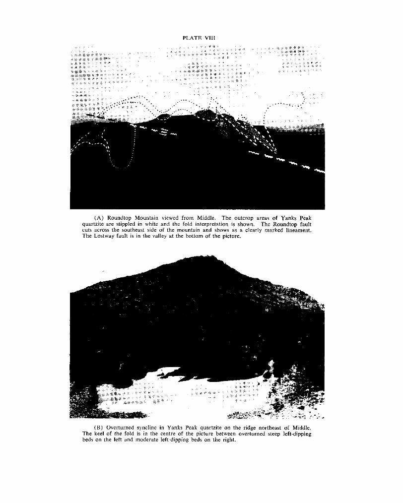
PLATE VI11
( A ) Roundtop Mountain viewed from Middle. The outcrop areas of Yanks Peak quartzite are stippled in white and the fold interpretation is shown. The Roundtop fault cuts across the southeast side of the mountain and shows as a clearly marked lineament. The Lostway fault is in the valley at the bottom of the picture,
The keel of the fold is in the centre of the picture between overturned steep left-dipping (B) Overturned syncline in Yanks Peak quartzite on the ridge northeast of Middle,
beds on the left and moderate left~dipping beds on the right.