WVGISTC 2007 annual report 18Dec07 - West Virginia...
8
WV GIS Technical Center ANNUAL REPORT Fiscal Year 2007 Mission: Provides focus, direction and leadership to users of geographic information systems (GIS), digital mapping and remote sensing within the State of West Virginia. The WV GIS Technical Center (WVGISTC) was established under Executive Order No. 4‐93 in November 1993, which specified that the Technical Center should provide technical support services to support the development and operation of GIS in West Virginia. Objectives: o Reduce the duplication of GIS data development efforts among organizations o Disseminate GIS spatial data, Web map services, mapping applications, and other geographic information free‐of‐charge through the Internet o Coordinate acquisition of new data additions to the West Virginia Spatial Data Infrastructure o Assist with strategic planning, development and implementation of GIS and mapping guidelines statewide o Provide advisory services and training programs in GIS o Conduct research and provide education towards improvement of geographic information technologies in West Virginia. Personnel: The staff consists of two geography professors who serve as co‐directors, five full‐time employees, and student and temporary employees hired periodically to accomplish project tasks. o Dr. Gregory Elmes, Co‐director o Dr. Trevor Harrris, Co‐director o Kurt Donaldson, Manager o Frank LaFone, Senior Internet Programmer o Eric Hopkins, GIS Analyst o Kevin Kuhn, GIS Analyst o Evan Fedorko, GIS Analyst (departed March 2007) Funding: Primary FY 2006‐07 funding of $295,000 received from the state‐appropriated Mineral Lands Mapping Program (Fund 0253, Activity 207) approved under House Bill 2222 in February 1995. Fiscal management of this program was delegated to the WV Geological & Economic Survey, with programmatic oversight by the GIS Policy Council. Additional external funding was obtained from several grants and service contracts.
Transcript of WVGISTC 2007 annual report 18Dec07 - West Virginia...

WV GIS Technical Center ANNUAL REPORT Fiscal Year 2007
Mission: Provides focus, direction and leadership to users of geographic information systems (GIS), digital mapping and remote sensing within the State of West Virginia. The WV GIS Technical Center (WVGISTC) was established under Executive Order No. 4‐93 in November 1993, which specified that the Technical Center should provide technical support services to support the development and operation of GIS in West Virginia.
Objectives: o Reduce the duplication of GIS data development efforts among organizations o Disseminate GIS spatial data, Web map services, mapping applications, and other geographic
information free‐of‐charge through the Internet o Coordinate acquisition of new data additions to the West Virginia Spatial Data Infrastructure o Assist with strategic planning, development and implementation of GIS and mapping guidelines
statewide o Provide advisory services and training programs in GIS o Conduct research and provide education towards improvement of geographic information
technologies in West Virginia.
Personnel: The staff consists of two geography professors who serve as co‐directors, five full‐time employees, and student and temporary employees hired periodically to accomplish project tasks. o Dr. Gregory Elmes, Co‐director o Dr. Trevor Harrris, Co‐director o Kurt Donaldson, Manager o Frank LaFone, Senior Internet Programmer o Eric Hopkins, GIS Analyst o Kevin Kuhn, GIS Analyst o Evan Fedorko, GIS Analyst (departed March 2007) Funding: Primary FY 2006‐07 funding of $295,000 received from the state‐appropriated Mineral Lands Mapping Program (Fund 0253, Activity 207) approved under House Bill 2222 in February 1995. Fiscal management of this program was delegated to the WV Geological & Economic Survey, with programmatic oversight by the GIS Policy Council. Additional external funding was obtained from several grants and service contracts.

WV GIS Technical Center, WVU Department of Geology & Geography, 330 Brooks Hall, P.O. Box 6300, Morgantown, WV 26506 Phone : (304)2930557 FAX : (304)2936522
Kurt Donaldson, Manager [email protected]
2
Projects and Activities FY 2007: Build and Disseminate State’s Spatial Data Infrastructure: Digital data conversion, data development, and coordination with federal geospatial data initiatives, statewide mapping programs, and local (county, municipal) data producers. Data clearinghouse at http://wvgis.wvu.edu//data/data.php
o SAMB Base Layer Development: Center collaborates with the Statewide Addressing and Mapping Board (SAMB), USGS, and other partners to create a value‐added, high resolution 1:4800‐scale digital base map for West Virginia. Elevation, transportation, streams and administrative map layers benefit mapping in the entire state community; government, private and non‐profit.
National Hydrology Dataset (NHD) Initiated development of an attributed, linear referenced, 1:4800‐scale local resolution
hydrography data set for two 8‐digit watersheds: Upper Guyandotte (05070101) and Gauley (05050005).
Validated completeness of 1:4800‐scale hydrographic geometry derived from the SAMB project and posted this new stream geographic database on the State Data Clearinghouse.
Cooperated with USGS and WVU Natural Resources Analysis Center to develop new NHD geo‐conflation tools.
Attended and presented progress and results at the NHD Stewardship conference in April 2007 at Denver, Colorado.
Received funding from the USGS through Great Lakes‐Northern Forest Cooperative Ecosystems Studies Unit.
National Elevation Dataset A value‐added statewide grid elevation dataset originating from the SAMB project was
made publicly available via file download and Web map services. West Virginia is the first state in the Nation to have complete statewide coverage of 1/9 arc‐second (3‐meter) resolution digital elevation data as part of the USGS National Elevation Dataset (NED). This accomplishment is a major milestone in the ongoing development of new high resolution datasets for the State of West Virginia and for the Nation, and directly supports the vision of the National Spatial Data Infrastructure (NSDI).
Created statewide 20‐foot contours from the 3‐meter grid elevation dataset. Available via FTP download or Web map service.
WV GIS Technical Center, WVU Department of Geology & Geography, 330 Brooks Hall, P.O. Box 6300, Morgantown, WV 26506 Phone : (304)2930557 FAX : (304)2936522
Kurt Donaldson, Manager [email protected]
3
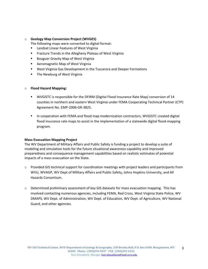
o Geology Map Conversion Project (WVGES) The following maps were converted to digital format: Landsat Linear Features of West Virginia Fracture Trends in the Allegheny Plateau of West Virginia Bouguer Gravity Map of West Virginia Aeromagnetic Map of West Virginia West Virginia Gas Development in the Tuscarora and Deeper Formations The Newburg of West Virginia
o Flood Hazard Mapping:
WVGISTC is responsible for the DFIRM (Digital Flood Insurance Rate Map) conversion of 14 counties in northern and eastern West Virginia under FEMA Cooperating Technical Partner (CTP) Agreement No. EMP‐2006‐GR‐3825.
In cooperation with FEMA and flood map modernization contractors, WVGISTC created digital flood insurance rate maps to assist in the implementation of a statewide digital flood‐mapping program.
Mass Evacuation Mapping Project The WV Department of Military Affairs and Public Safety is funding a project to develop a suite of modeling and simulation tools for the future situational awareness capability and improved preparedness and consequence management capabilities based on realistic estimates of potential impacts of a mass evacuation on the State. o Provided GIS technical support for coordination meetings with project leaders and participants from
WVU, WVAGP, WV Dept of Military Affairs and Public Safety, Johns Hopkins University, and All Hazards Consortium.
o Determined preliminary assessment of key GIS datasets for mass evacuation mapping. This has involved contacting numerous agencies, including FEMA, Red Cross, West Virginia State Police, WV DMAPS, WV Dept. of Administration, WV Dept. of Education, WV Dept. of Agriculture, WV National Guard, and other agencies.

WV GIS Technical Center, WVU Department of Geology & Geography, 330 Brooks Hall, P.O. Box 6300, Morgantown, WV 26506 Phone : (304)2930557 FAX : (304)2936522
Kurt Donaldson, Manager [email protected]
4
Map West Virginia (WV Geographic Information Network): "MapWV" is a public gateway to online mapping resources in the Mountain State. MapWV comprises Internet services: online map viewers, web mapping services, metadata catalogs, and FTP downloadable services. http://www.mapwv.gov/
Internet Map Service Development: Assists the Department of Health and Human Resources (DHHR), the Department of Natural Resources, the State Historic Preservation Office (SHPO), the State Flood Insurance Program Coordinator, and other state agencies to create Internet databases and mapping systems for intra‐agency and public use.
o DNR Trout Stream Web Application Public access project with custom interface for Trout Streams in WV Housing and serving of project for the coming fiscal year and expected beyond
o DHHR Secure Internet Mapping Application
Creation of secure access to service water areas Housing and serving of the project in the coming fiscal year Organize and Coordinate the NHD users community for comments and concerns of the current
NHD and future Local Res NHD for West Virginia
o SHPO Internet Mapping Application: Created a prototype Internet mapping application for cultural and archeological resources of the State Historic Preservation Office.
o WV Flood Determination Tool (Figure 4) Funded by FEMA and the State National Flood Insurance Program Coordinator, this Internet
mapping application allows the public to locate their property and ascertain if they are within or in proximity of any identified flood hazard areas.
It provides the user the ability to identify an elevation value at any geographic location using the new statewide high‐resolution elevation data which has an accuracy of plus or minus 10 vertical feet. It incorporates the best available reference mapping layers such as the new statewide color orthophotos.
For counties where modern digital flood maps are available, it links users to FEMA’s flood insurance rate map library.
o Grade School Internet Mapping Application: Created a statewide grade school Internet mapping
application utilizing Google maps and Web map hosted on WVGISTC map servers.
WV GIS Technical Center, WVU Department of Geology & Geography, 330 Brooks Hall, P.O. Box 6300, Morgantown, WV 26506 Phone : (304)2930557 FAX : (304)2936522
Kurt Donaldson, Manager [email protected]
5
Strategic Planning: Assists with strategic planning, development, and implementation of statewide GIS. Coordinates with state, federal, local government and private sector entities to define, refine, and implement the GIS Coordinating Council and State GIS Strategic Plan.
o As part of the Fifty States Initiative, WVGISTC and other state partners received a cooperative assistance program grant from the Federal Geographic Data Committee to create a new GIS coordinating body for West Virginia (Figure 2). This new coordinating body, named the WV Association of Geospatial Professionals (WVAGP), approved bylaws and elected officers in March 2007. WVAGP is interdependent with other coordinating bodies and provides a broad‐level representation to include the private sector, academia, and all levels of government.
o WVGISTC and other state partners have begun working on creating a State GIS Plan to replace the 1993 GIS Development plan.
o WVGISTC was the primary drafter of procedural and legislative tax map rules that were approved in May 2007 by the WV Property Valuation Training and Procedures Commission (Figure 5).
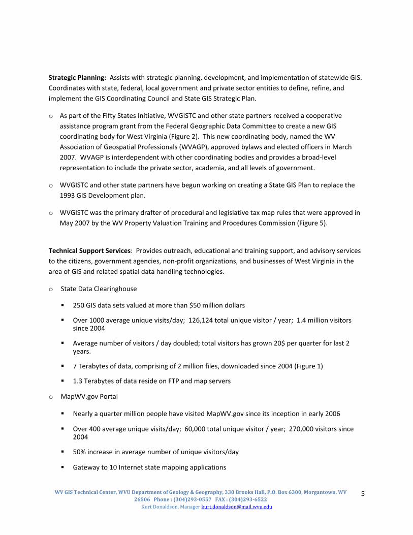
Technical Support Services: Provides outreach, educational and training support, and advisory services to the citizens, government agencies, non‐profit organizations, and businesses of West Virginia in the area of GIS and related spatial data handling technologies.
o State Data Clearinghouse
250 GIS data sets valued at more than $50 million dollars
Over 1000 average unique visits/day; 126,124 total unique visitor / year; 1.4 million visitors since 2004
Average number of visitors / day doubled; total visitors has grown 20$ per quarter for last 2 years.
7 Terabytes of data, comprising of 2 million files, downloaded since 2004 (Figure 1)
1.3 Terabytes of data reside on FTP and map servers
o MapWV.gov Portal
Nearly a quarter million people have visited MapWV.gov since its inception in early 2006
Over 400 average unique visits/day; 60,000 total unique visitor / year; 270,000 visitors since 2004
50% increase in average number of unique visitors/day
Gateway to 10 Internet state mapping applications

WV GIS Technical Center, WVU Department of Geology & Geography, 330 Brooks Hall, P.O. Box 6300, Morgantown, WV 26506 Phone : (304)2930557 FAX : (304)2936522
Kurt Donaldson, Manager [email protected]
6
Over 30 Web map services allow users to connect to "live" map data
o Service Activities (Walk in/email/Phone Service): Roughly 18 man hours per week
o Training: Six "Introduction to GIS" classes taught by certified ESRI instructors
Figure 1: Download of map files in Gigabytes from State Data Clearinghouse
Figure 2: Charting meeting of new GIS coordination body named the WV Association of Geospatial Professionals. The Federal Geographic Data Committee awarded WGISTCS a grant to assist in the creation of this new organization.

WV GIS Technical Center, WVU Department of Geology & Geography, 330 Brooks Hall, P.O. Box 6300, Morgantown, WV 26506 Phone : (304)2930557 FAX : (304)2936522
Kurt Donaldson, Manager [email protected]
7
Figure 3: Data products and applications resulting from the statewide, high‐resolution elevation data created by WVGISTC and other partners
New elevation data in Google Maps
Photorealistic photo draped over elevation data
Flood predictive model using new elevation data
The West Virginia 3‐meter resolution elevation data represents the highest resolution product maintained in the national elevation database by the U.S. Geological Survey
USGS elevation status map showing WV as the only state with 3‐meter elevation data

WV GIS Technical Center, WVU Department of Geology & Geography, 330 Brooks Hall, P.O. Box 6300, Morgantown, WV 26506 Phone : (304)2930557 FAX : (304)2936522
Kurt Donaldson, Manager [email protected]
8
Figure 4: The Flood Hazard Determination Tool, an online mapping application, determines if a resident lives in a flood hazard area. WVGISTC created this application for FEMA and the WV NFIP Coordinator. This application is receiving national acclaim from FEMA.
Figure 5: Revised tax map standard drafted by WVGISTC for the Property Valuation Training and Procedures Commission