Wrl crop insurance2.0
48
-
Upload
arijit1985 -
Category
Investor Relations
-
view
52 -
download
0
Transcript of Wrl crop insurance2.0

C R O PI N S U R A N C E S O L U T I O N S -O V E R V I E W
S O N U A G R A W A L
M A N A G I N G D I R E C T O R
sonu.agrawal@weather- r isk .com N O V E M B E R 2 0 1 4

To provide all in the world security against climate change as the world’s No. 1 climate risk management company innovatively combining Big Data, Analytics, Smart Devices & Financial Services
Founded2004
Team101 People
AsiaPhilippines
Cambodia
InvestorsSIDBI / IIT / ILO
Ford Foundation
Global FootprintIN / Africa / EU / US / LatAM
V I S I O N W H AT W E D O C L I E N T S T E AM I M PAC T O P P O R T U N I TY
Cambodia
Bangladesh
Sri Lanka
AfricaTanzania
Rwanda
Zambia
Mozambique
Existing Presence
Building Presence

We are a global Risk Management company delivering
innovative products and services to large enterprises as well
as farmers in the remotest of villages worldwide.
Big Data Services & Analytics
Smart Devices & Technology
Weather Insurance1 2 3� India
� Global
� Agri Information Systems
� Weather Forecasting
� Remote Sensing
� Automated Weather Stations
� Vehicle Tracking Systems
� Energy Efficiency
V I S I O N W H AT W E D O C L I E N T S T E AM I M PAC T O P P O R T U N I TY
as farmers in the remotest of villages worldwide.
2004 2006 2008 2010 2012 2004 2006 2008 2010 2012
Founded with
ICICI Lombard as
the first client
SIDBI Seed Fund
Incubation at IIT
Kanpur
Ford Foundation
grant
Convinced GoI for regulatory
approval & subsidize weather
insurance with Rs. 1000 Cr.
Stabilizing pan-
India business
AWS Grid
~ 100 Stations
SIDBI invests for
working capital
First International
projects in Tanzania
and Bangladesh
Expansion of Products
& Services to Africa &
ASEAN
2005 2007 2009 2011 20142005 2007 2009 2011 2014

V I S I O N W H AT W E D O C L I E N T S T E AM I M PAC T O P P O R T U N I TY

Vijay MahajanMentor
Founder & Chief Executive Officer
Basix Social Enterprise Group
Dr. AK BohraDirector
Weather Scientist and Former Director
National Centre for Medium Range Weather Forecasting
Pankaj KhandelwalDirector
Chairman & Managing Director
A D V I S O R Y B O A R D
Sonu Agrawal, 39Founder & Managing Director
Weather & Climate Risk Pioneer
IIT Kanpur and IIM Calcutta Alumnus
Anuj Khumbat, 38Chief Executive Officer
Finance and Management Specialist
Chartered Accountant
E X E C U T I V E T E A M
Ashish Agarwal, 31Chief Technology Officer
V I S I O N W H AT W E D O C L I E N T S T E AM I M PAC T O P P O R T U N I TY
Chairman & Managing Director
INI Farms
Dr. Kanti PrasadDirector
Weather Scientist and Former Dy. Director General
Indian Meteorological Department
Dr. BV PhaniDirector
Professor / Finance
Indian Institute of Technology - Kanpur
Dr. Jayant K. SinghTechnology Advisor
Professor / Chemical Engineering
Indian Institute of Technology - Kanpur
Passionate and Diverse Team101 people with expertise in:
T E A M W R L
FINANCIAL RISK MANAGEMENT
COMPUTER SCIENCE
METEOROLOGY
ATMOSPHERIC PHYSICS
CLIMATOLOGY
ELECTRONICS & INDUSTRIAL DESIGN
Electronics and Technology Specialist
IIT Kanpur Alumnus

Industry Leader with robust,
comprehensive and integrated services
Weather Insurance1
Underwriting Services for Insurance Companies ����
�
Risk Management Application
� Fraud Analytics
• Claims Control
V I S I O N W H AT W E D O C L I E N T S T E AM I M PAC T O P P O R T U N I TY
• Claims Control
• Remote Sensing & UAV
� Portfolio Risk Management
Reinsurance Services ����
Market Making ����
As market makers we help financial institutions & companies to design / execute
innovative risk offerings in Agriculture & Power
���� We work with several farmer associations
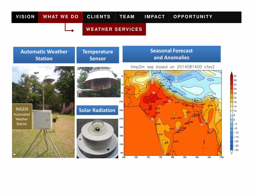
W E AT H E R S E RV I C E S
Automatic Weather
Station
Temperature
Sensor
Seasonal Forecast
and Anomalies
V I S I O N W H AT W E D O C L I E N T S T E AM I M PAC T O P P O R T U N I TY
Solar Radiation

V I S I O N W H AT W E D O C L I E N T S T E AM I M PAC T O P P O R T U N I TY
S AM P L E F O R E C AS T
7 Days Forward Forecast for every 15 minutes interval / updated every 6 hours

V I S I O N W H AT W E D O C L I E N T S T E AM I M PAC T O P P O R T U N I TY
W E AT H E R I N S U R AN C E AN ALY T I C S P L AT F O R M
9

Arial SurveysRemote Sensing
V I S I O N W H AT W E D O C L I E N T S T E AM I M PAC T O P P O R T U N I TY
C R O P AS S E S S M E N T & E VAL U AT I O N
10
Cloud Sourcing

Get Market Prices
Get Temperature Data
Get Insurance
Monsoon Outlook
�Location�Commodity�Unit�Price
�Max Temperature�Min Temperature
�Product�Location�Sum Insured� Get Premium
�Monsoon Outlook by Dr. Kanti Prasad
V I S I O N W H AT W E D O C L I E N T S T E AM I M PAC T O P P O R T U N I TY
AG R I C U LT U R E I N F O R M AT I O N S Y S T E M S
11
Get Satellite Data
Get NDVI Data
Get Forecast
�Data Date�Rain
�Year�Month
�Max Temp�Min Temp�Rain�Humidity�Wind Speed�Wind Direction
Kanti Prasad
Click to View Video

Business Case What we did Impact
Cholamandalam • WRL helped to structure Weather and • Cholamandalam
Cholamandalam is a leading Indian general insurance company. In 2011 Weather Risk was hired to help structure Weather and Yield Index based Crop Insurance Products.
V I S I O N W H AT W E D O C L I E N T S T E AM I M PAC T O P P O R T U N I TY
Representative Case Study
Cholamandalam
wanted to establish
a robust Crop
Insurance Products
portfolio
• WRL helped to structure Weather and
Yield Index based products as well as
advised Cholamandalam to manage its
Crop Insurance portfolio.
• We helped to build necessary banking
channels for sales and distribution.
• WRL also installed Weather Stations and
conducted claim settling audits.
• Cholamandalam
generated a premium
income of US $ 20m in FY
13 - 14
• The portfolio covers
20000 farmers in Bihar
and Rajasthan
• WRL continues to help
Cholamandalam target
US $40 m in 2014 - 15

Business Case What we did Impact
Large Scale • WRL embarked on an exercise to • The Ministry kindly
Since 2007 we have helped ICICI Lombard implement a joint nationwide weather and agriculture Insurance market making and strategic development exercise.
V I S I O N W H AT W E D O C L I E N T S T E AM I M PAC T O P P O R T U N I TY
Representative Case Study
Large Scale
implementation of
subsidized weather
insurance program
• WRL embarked on an exercise to
remove technological, policy level and
reinsurance capacity bottlenecks.
• WRL developed low cost weather
stations, unmanned aerial vehicles, and
automated yield measurement
instruments to facilitate claim
settlement.
• WRL also pursued the Ministry of
Agriculture for subsidy support.
• The Ministry kindly
consented in 2007 and
granted support to
Weather Insurance
Products.
• In Rabi 2009 - 10 season
WRL covered close to
4000 farmers for 10000
acres in just 2 districts of
West Bengal.

Business Case What we did Impact
Difficult to extend • WRL worked with the PepsiCo ground • Program successfully
Late Blight is a lethal potato disease. In 2006 PepsiCo contract farmers lost 60 % of their crops due to this bane. We helped PepsiCo provide risk management to over 10000 farmers in Punjab.
V I S I O N W H AT W E D O C L I E N T S T E AM I M PAC T O P P O R T U N I TY
Representative Case Study
Difficult to extend
cover under
existing Crop
Insurance programs
due to moral hazard
• WRL worked with the PepsiCo ground
team in Punjab.
• Our analysis indicated high correlations
with location humidity and
temperature.
• We created an index to cover blight risk
specific to the region.
• Additional weather stations were
installed to minimize basic risk – critical
for extending this kind of cover.
• Program successfully
running in its 9th year.
• Covers 10000 potato
farmers in Punjab.
• Strong demonstration of
how insurance can be
used by contract farming
companies to sustain
their grower base.

Business Case What we did Impact
Innovation for • Bayer Bio Science was facing a risk of • The cover was
We have helped Bayer face the challenge of insufficient data availability and develop an innovative Cloud Cover product helping to insure seed crop during pollination under cloudy conditions.
V I S I O N W H AT W E D O C L I E N T S T E AM I M PAC T O P P O R T U N I TY
Representative Case Study
Innovation for
Cloud Cover
• Bayer Bio Science was facing a risk of
loss of its seed crop on account of
cloudy conditions during pollination
• Due to lack of historical data for cloud
coverage, insurance companies were
not able to design a suitable product to
cover the possible losses of Bayer
• We designed a cover correlating rainfall
of all weather stations within a 50 km
radius of the cropped location to cover
the risk of cloud cover.
• The cover was
successfully tested in
sample of 200 acres.
• Bayer is now working on
a product launch

� Indian Market:
– Provide tools for risk assessment and evaluation for
Weather and Yield Insurance in India: other than already
serviced clients
– Offer comprehensive reinsurance services to smaller
players in the market who are not offered capacity by
V I S I O N W H AT W E D O C L I E N T S T E AM I M PAC T O P P O R T U N I TY
What we can do
with Willis Re
players in the market who are not offered capacity by
major reinsurers
• Risk Assessment and Evaluation to be done by WRL
• Reinsurance placements to be arranged by Willis Re
– Include Agriculture Insurance in the general Cat-XL given to
insurance companies in India
• This well help optimize Cat-XL treaty for insurer
– Risk Evaluation inputs to be given by WRL
– Placements to be arranged by Willis Re

• Project: Launching Index Insurance in Bangladesh
• Objective: Index Insurance through ADB project client Sadharan
Bima Corporation / Donor: Asian Development Bank
• Work Done:
– Have collected all the available weather data available in the country
– Have completed feasibility study for launching Index Insurance (IFC Funded)
V I S I O N W H AT W E D O C L I E N T S T E AM I M PAC T O P P O R T U N I TY
Global Market Development:
Weather InsuranceB AN G L AD E S H
– Have completed feasibility study for launching Index Insurance (IFC Funded)
– Have investment plan ready for the launch of the product
• Risks Covered:
– Phase-wise launch starting with simple weather indexes on Deficit and Excess
Rainfall in Phase I
– Phase II launch of complex products such as Flood & Cyclone Index Covers
• Business Size:
– Intend to cover 3000 farmers in the first season but overall 20000 farmers
during project duration

• Project: Launching Index Insurance for Paddy farmers in Cambodia
• Objective: Covering borrower farmers of a Large MFI client of
insurance company / Partner: Forte General Insurance Co.
• Work Done:
– Have rainfall data of the all the major weather observatories in the Country
– Initial product has been designed and proposal submitted by insurance
V I S I O N W H AT W E D O C L I E N T S T E AM I M PAC T O P P O R T U N I TY
Global Market Development:
Weather InsuranceC AM B O D I A
– Initial product has been designed and proposal submitted by insurance
company to client
• Risks Covered:
– Drought resulting in increased cost of operations for Paddy Farmer
– Unusually long break in monsoon captured in the form of Dry Days Index
– Unseasonal severe rainfall resulting in loss of paddy crop
• Business Size:
– Intend to cover 5000 farmers in the first season

• Project: Testing NDVI based Index Insurance for Pasture-land in some
areas of Mexico
• Objective: Covering rangeland owners through NDVI based
insurance / Partner: Proagro Seguros
• Work Done:
– Have rainfall data of the all the major weather observatories in the Country
V I S I O N W H AT W E D O C L I E N T S T E AM I M PAC T O P P O R T U N I TY
Global Market Development:
Weather InsuranceM E X I C O
– Have rainfall data of the all the major weather observatories in the Country
– Initial product has been designed and proposal submitted by insurance
company to client
• Risks Covered:
– Drought resulting in increased cost of operations for Paddy Farmer
– Unusually long break in monsoon captured in the form of Dry Days Index
– Unseasonal severe rainfall resulting in loss of paddy crop
• Business Size:
– Overall Index Insurance market is of around USD 400 million in Premium

• Project: Crop & Weather Insurance for Maize, Beans & Horticulture
Crops
• Partner: Leading insurers / Commodity Exchange in South Africa
• Work Done:
– Designed few products for Horticulture Crops
– Have rainfall and temperature data of few stations in South Africa
V I S I O N W H AT W E D O C L I E N T S T E AM I M PAC T O P P O R T U N I TY
Global Market Development:
Weather InsuranceS O U T H AF R I C A
– Have rainfall and temperature data of few stations in South Africa
• Risks Covered:
– Frost Loss to Grapes
– Loss due to unseasonal rainfall
– Drought

• Project: Installation of Automatic Weather Station for insurance
settlement
• Partner: MicroEnsure, Bankable Frontier
• Work Done:
– Have done IFC / SDC / World Bank funded feasibility study & Risk Review
Projects in Zambia, Malawi, Kenya & Mozambique
V I S I O N W H AT W E D O C L I E N T S T E AM I M PAC T O P P O R T U N I TY
Global Market Development:
Weather InsuranceE AS T & C E N T R AL AF R I C A
Projects in Zambia, Malawi, Kenya & Mozambique
– Have installed 60 AWS stations in Tanzania and Rwanda
– Stations measure Rainfall, Temperature and RH
• Further Work
– Review of Insurance program in Malawi
– Launching Index Insurance projects in Mozambique and Malawi

� International Market
– Product Development & Portfolio Risk Assessment
• WeatherSecure Platform can be used for:
– Designing and Pricing weather / yield insurance products for any crop in any country
– Portfolio Risk Evaluation and Assessment
– Weather Station Installation for settlement of Weather
Insurance Contracts
V I S I O N W H AT W E D O C L I E N T S T E AM I M PAC T O P P O R T U N I TY
What we can do
with Willis Re
Insurance Contracts
– Yield Assessment / Claims Management
• Using Ground Surveys and Satellite Imagery for estimating crop yields or
evaluating flood losses
22

The sky is not the limit
C R O P I N S U R A N C E –D E S I G N , P R I C I N G , R I S K A S S E S S M E N T
S O N U A G R A W A L
sonu.agrawal@weather- r isk .com
N O V E M B E R 2 0 1 4

SecureWeather Risk Management Application for
Insurance Business
V I S I O N W H AT W E D O C L I E N T S T E AM I M PAC T O P P O R T U N I TY
� Key Features
• Secure Machine independent web-
based tool allows flexibility of use
• Comprehensive Termsheet options
� Application Architecture
• Comprehensive Termsheet options
allow complete migration from
error-prone Excel based workings
• Large database of cleaned and
enhanced weather and satellite data
from various sources
• Provide Portfolio Analytics and
Monitoring Tools

SecureWeather Risk Management Application for
Insurance Business
V I S I O N W H AT W E D O C L I E N T S T E AM I M PAC T O P P O R T U N I TY
� Historical Data Manager
• Secure upload & access to all weather
data in database
• Tools for identifying errors in data
• Options to compare data with nearby • Options to compare data with nearby
locations
• Tools for data cleaning & gap filling
� HDM Snapshots

All India Data: Historical Data Manager now contains historicalweather parameter data for each and every part of India
Filling Options: New options have been added in data filling to allowmore control over filled data. Backup data filling can now be used tofill data for only uploaded months, uploaded years or any day data
SecureHistorical Data Manager
V I S I O N W H AT W E D O C L I E N T S T E AM I M PAC T O P P O R T U N I TY

SecureProduct Development Application
V I S I O N W H AT W E D O C L I E N T S T E AM I M PAC T O P P O R T U N I TY
• Includes both Weather & Crop Insurance Products
• Can make diverse term sheets in single module
• Accommodates large variety of term sheets required for Indian MarketIndian Market
• Almost 95% of term sheet can be made on the App
• Upto 50 locations can be priced in Single Termsheet
• Allows de-trending and VAR Distribution fitting
• Normal, Lognormal and Gamma Distribution included
• Goodness of fit details are provided
• Allows user change the return on capital rate for pricing

SecurePDA Snapshots
V I S I O N W H AT W E D O C L I E N T S T E AM I M PAC T O P P O R T U N I TY

SecurePortfolio Builder
V I S I O N W H AT W E D O C L I E N T S T E AM I M PAC T O P P O R T U N I TY
� Can build one or more portfolio with different
weights or sales scenarios
� Portfolio gets automatically updated for any � Portfolio gets automatically updated for any
change in individual termsheets
� Allows additions and deletions in the Portfolio
� Displays Basic Portfolio Statistics
� Allows VAR Distribution fitting & de-trending
on the Portfolio payoffs

SecurePortfolio
V I S I O N W H AT W E D O C L I E N T S T E AM I M PAC T O P P O R T U N I TY
GIS Display Displays the portfolio locations with PML distribution in
GIS. Any location marker can be clicked to get the acreage, structure
detail and historical index of the structure for that location.

SecureClaims Manager
V I S I O N W H AT W E D O C L I E N T S T E AM I M PAC T O P P O R T U N I TY
� Claims monitoring for both
Weather and Crop Insurance
� GIS mapping of claims� GIS mapping of claims
� Comparison with claims in adjacent
weather stations
� Real-time monitoring possible if
data is updated
� Claim sheets can be extracted in
Excel for govt submission

SecureCMA Snapshot
V I S I O N W H AT W E D O C L I E N T S T E AM I M PAC T O P P O R T U N I TY

The sky is not the limit
C R O P I N S U R A N C E – C L A I M A S S E S S M E N T
S O N U A G R A W A L
sonu.agrawal@weather- r isk .com
N O V E M B E R 2 0 1 4

V I S I O N W H AT W E D O C L I E N T S T E AM I M PAC T O P P O R T U N I TY
Y I E L D E S T I M AT I O NV I D E O G R AP H Y & C L O U D S O U R C I N G
� ANDROID Application for SmartPhones

V I S I O N W H AT W E D O C L I E N T S T E AM I M PAC T O P P O R T U N I TY
Y I E L D E S T I M AT I O NV I D E O G R AP H Y & C L O U D S O U R C I N G
In - Season Crop Damage / Loss Yield Estimation
Dividing crop
period into
different
vegetative and
reproductive
stages.
� Vegetative stages – counted as consecutive
unfolded leaves, until the reproductive parts
are visible on the plants.
� Reproductive stages – as soon as the
flowers/tuber/ear head are visible until all the
kernels/seed/tuber are physiologically mature.
Crop damage
based on parts of
the crop which is
damaged.
� Crop Stand damage – Count or percentage
of crop stand area with no living axils/buds.

V I S I O N W H AT W E D O C L I E N T S T E AM I M PAC T O P P O R T U N I TY
Y I E L D E S T I M AT I O NV I D E O G R AP H Y & C L O U D S O U R C I N G
In-Season Crop Damage/Loss Yield Estimation
Crop damage
based on parts
of the crop
which is
damaged.
�Crop stem damage – Count and
percentage of crop stem snapped off with
physiologically unable to produce yield or
inactive.
�Branch damage – Position and percentage
of branches snapped off or damaged.of branches snapped off or damaged.
�Leaf damage - Count and percentage of
leaves are snapped off, shredded, de-
colourized and physiologically inactive that
wilts and dies.
�Ear/Pod/Head/Boll damage – Count and
percentage of yield part knocked
off/chaffed/shriveled/
broken or disease/pest infected.

In-Season Crop Damage/Loss Yield Estimation
Fruit damage � Count and percentage of fruits/ tree knocked
off/ malformed/ disease/pest infected and
quality degraded.
�Crop Yield
estimation
before
� Locating representative sample area.
� Determining the plant stand and row width.
V I S I O N W H AT W E D O C L I E N T S T E AM I M PAC T O P P O R T U N I TY
Y I E L D E S T I M AT I O NV I D E O G R AP H Y & C L O U D S O U R C I N G
before
harvesting
period.� Determining the plants (or ear/ fruit/ pod)
sample population / 100 sq mt.
� Filling observation report.
� Estimating the yield based on observations.
Forecast Yield (Y) = F (seed weight, plants, row width)
Y = …… t/ha
Yield Loss = Normal Yield – Forecast yield

V I S I O N W H AT W E D O C L I E N T S T E AM I M PAC T O P P O R T U N I TY
Y I E L D E S T I M AT I O NV I D E O G R AP H Y & C L O U D S O U R C I N G

V I S I O N W H AT W E D O C L I E N T S T E AM I M PAC T O P P O R T U N I TY
Y I E L D E S T I M AT I O NV I D E O G R AP H Y & C L O U D S O U R C I N G

V I S I O N W H AT W E D O C L I E N T S T E AM I M PAC T O P P O R T U N I TY
Y I E L D E S T I M AT I O NU AV & S AT E L L I T E
UAV Images from 100 meters
Object - based hierarchical image analysis to classify imagery of
plots measured concurrently on the ground using standard
rangeland monitoring procedures.

V I S I O N W H AT W E D O C L I E N T S T E AM I M PAC T O P P O R T U N I TY
Y I E L D E S T I M AT I O NU AV & S AT E L L I T E
UAV Images using regular camera from 250 meters
Objects are further classified into vegetative groups and to
species level by Rule Based Classification with well defined
thresholds and Near Neighbor Classification Algorithm, feasible
for few crops.

V I S I O N W H AT W E D O C L I E N T S T E AM I M PAC T O P P O R T U N I TY
Y I E L D E S T I M AT I O NU AV & S AT E L L I T E
UAV Images using spectral camera from 250 meters

V I S I O N W H AT W E D O C L I E N T S T E AM I M PAC T O P P O R T U N I TY
Y I E L D E S T I M AT I O NU AV & S AT E L L I T E

� Monitor Yields through Satellite
images (LISS4, LANDSA, SAR).
� We use LANDSAT images of
resolution 30m*30m.
V I S I O N W H AT W E D O C L I E N T S T E AM I M PAC T O P P O R T U N I TY
Y I E L D E S T I M AT I O NU AV & S AT E L L I T E
Methodology
resolution 30m*30m.
� In case, of more detailed analysis,
will use LISS4 images of 5m*5m
resolution.
� Where visibility is affected due to
clouds, Microwave SAR data can be
used.

Methodology
Stasny-Goel method
(Bayesian method)
Bayesian yield estimation algorithm with a simple spatial component based on
the crop yields (close geographic proximity tend to be more similar than those
further apart).
Griffith method (AR
model)
Box-Cox and Box-Tidwell transformations are employed in conjunction with an
autoregressive specification so as to optimize agreement with model
assumptions.
V I S I O N W H AT W E D O C L I E N T S T E AM I M PAC T O P P O R T U N I TY
Y I E L D E S T I M AT I O NM O D E LL I N G
assumptions.
Standard ratio estimation Multi-Phase stratified sampling is used to generate ratio estimates that are
weighted by the sampling rate.
Econometric methodology Use of Econometric principles and model building by considering endogenous
and exogenous variables such as prices of both product and inputs, farmer
planting decision and consumer preferences, etc..
Agro-Met methodology These model are crop growth stimulation model which is a function of
complex interaction of different physiological processes with the environment,
biotic and a biotic factors.
Geographic Information
System and Remote
Sensing Methodology
These model use RS and GIS information for quick assessment based on
multispectral, large area. Best for taking critical decision on procurement,
transportation, storage and trade.

Frame work for Integrated Crop Yield Forecast
Growth Monitoring
- Crop phenology,
Vegetative Index (NDVI)
Crop Survey, AWS and Satellite Data
Input
Empirical Method
YPA = f(xi)
Yield Per unit Area (YPA)
V I S I O N W H AT W E D O C L I E N T S T E AM I M PAC T O P P O R T U N I TY
Y I E L D E S T I M AT I O NM O D E LL I N G
Agro Meteorological
Data – Precipitation,
PAR, Water Holding
Capacity, GDD
Input YPA = f(xi)
Xi = Meteorological
indices, Drought Index,
Vegetative indices
Crop yield estimate
Yield = f(NDVI , Rain Index, GDD, Ancillary data)

Integrated Yield Estimation Model
Crop yield can be estimated by adopting advance technologies such as remote sensing imagery
(RS), Geographical Information system (GIS), etc. and appropriate methodologies such as
Multivariate regression.
Crop models with other important inputs from weather data, land based observations and
economic parameters that influence the farmer’s decision on cultivating particular crop.
V I S I O N W H AT W E D O C L I E N T S T E AM I M PAC T O P P O R T U N I TY
Y I E L D E S T I M AT I O NM O D E LL I N G
A general integrated yield estimation model for estimating crop yield.
Y = f (RD, RFs, W, S, Pt, I, G)
Y = Yield of the crop.
RD = Remote sensing imagery data (NDVI, SAR, IRS-WiFS, etc.)
RFs = Rainfall received during sowing and Vegetative stage.
W = other important weather parameters.
Pt = Previous year yield of the crop.
S = Soil type and its Parameters
I = Irrigated area availability.
G = Ground truth data by using CCE (crop cutting experiment) approach.

Parameters Source
Remote Sensing Imagery Landstat, NRRS, UAV’s and Aerial vehicles
Weather Data Ingen AWS, IMD, TRMM, GFS, NASA
Previous year’s Data State Govt. DES
V I S I O N W H AT W E D O C L I E N T S T E AM I M PAC T O P P O R T U N I TY
Y I E L D E S T I M AT I O NM O D E LL I N G
Previous year’s Data State Govt. DES
Fertilizer and Input Details State Agriculture Department
Soil Details NBSS & LUP
Irrigation Details Central Ground Water Board
Ground truth Data Weather Risk (Field Survey data)