Identity patterns and anit-patterns in real world web services

World Climatic Patterns -Part I
By SudarshanGurjar


Check out Previous Years Prelims Questions Trends- World Climate Patterns

The graph given below shows the mean average monthly temperatures (in ºC) and mean monthly rainfall (in cms) of a place: [1995]
This graph is indicative of which one of the climaticzones of the world?(a) Wet and dry tropical(b) Rainy tropical(c) Semi-arid tropical(d) Temperate marine
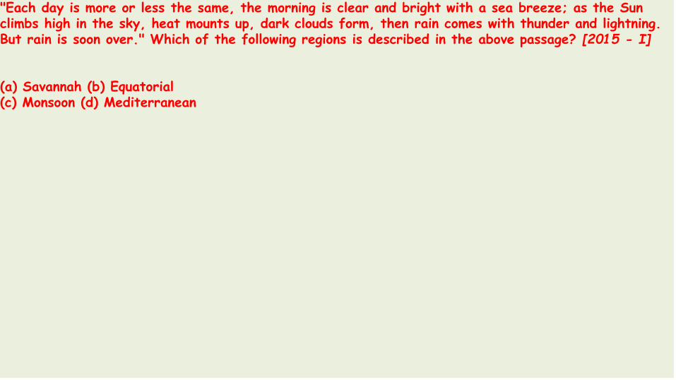
"Each day is more or less the same, the morning is clear and bright with a sea breeze; as the Sun climbs high in the sky, heat mounts up, dark clouds form, then rain comes with thunder and lightning. But rain is soon over." Which of the following regions is described in the above passage? [2015 - I]
(a) Savannah (b) Equatorial(c) Monsoon (d) Mediterranean

Willy Willy is: [1995]
(a) a type of tree grown in temperate regions(b) a wind that blows in a desert(c) a tropical cyclone of the north-west Australia(d) a kind of common fish found near Laccadives Islands

Which one of the following is the continent with the highest mean elevation in the world? [1995]
(a) Antarctica (b) North America(c) Asia (d) South America
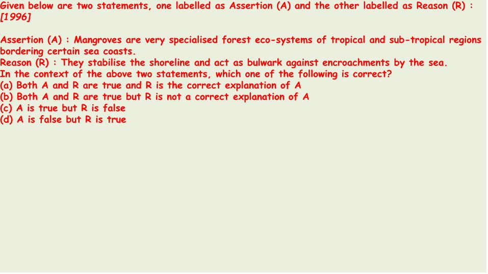
Given below are two statements, one labelled as Assertion (A) and the other labelled as Reason (R) : [1996]
Assertion (A) : Mangroves are very specialised forest eco-systems of tropical and sub-tropical regions bordering certain sea coasts.Reason (R) : They stabilise the shoreline and act as bulwark against encroachments by the sea. In the context of the above two statements, which one of the following is correct?(a) Both A and R are true and R is the correct explanation of A(b) Both A and R are true but R is not a correct explanation of A(c) A is true but R is false(d) A is false but R is true

Consider the map given below: [1997]
Of the four shaded areas in the map, which ischaracterised by hot dry summers, mild and moistwinters and seasonal reversal of winds.
(a) 1 (b) 2(c) 3 (d) 4

Physical regions marked as 1, 2, 3, and 4 on the given map are respectively: [1999]
(a) Andes, Brazilian Shield, Guyana Highlands and Amazon Basin(b) Andes, Guyana Highlands, Brazilian Shield and Amazon Basin(c) Amazon Basin, Guyana Highlands, Brazilians Shield and Andes(d) Guyana Highlands, Brazilian Shield Andes and Amazon Basin

Match List-I with List-II and select the correct answer using the codes given below the lists: [1999]
List-I (Timber) List-II (Country)A. Cedar 1. MyanmarB. Douglas Fir 2. CanadaC. Mahogany 3. MexicoD. Teak 4. Honduras
Codes:(a) A - 3; B- 2; C- 1; D-4(b) A - 3; B- 2; C- 4; D-1(c) A - 2; B- 3; C- 4; D-1(d) A - 2; B- 3; C- 1; D-4

Consider the following statements: [2002]
1. In equatorial regions, the year is divided into four main seasons2. In Mediterranean region, summer months receives more rain.3. In China type climate; rainfall occurs throughout the year4. Tropical highlands exhibit vertical zonation of different climates
Which of these statements are correct?(a) 1, 2, 3 and 4 (b) 1, 2 and 3(c) 1, 2 and 4 (d) 3 and 4

Consider the following ecosystems: [2002]
1. Taiga 2. Tropical Evergreen3. Tropical Deciduous 4. Tundra
The correct sequence in decreasing order of the Albedo values of these ecosystems is :(a) 1, 4, 3, 2 (b) 4, 1, 3, 2(c) 4, 1, 2, 3 (d) 1, .4, 2, 3

Assertion (A) : Unlike temperate forests, the tropical rain forests, if cleared, can yield productive farmland that can support intensive agriculture for several years even without chemical fertilizers.Reason (R) : The primary productivity of the tropical rain forest is very high when compared to that of temperate forests. [2003]
(a) Both A and R are individually true and R is the correct explanation of A.(b) Both A and R are individually true but R is not the correct explanation of A(c) A is true but R is false(d) A is false but R is true

Assertion (A) : Areas lying within five to eight degrees latitude on either side of the equator receive rainfall throughout the year.Reason (R) : High temperatures and high humidity cause convectional rain to fall mostly in the afternoons near the equator.
(a) Both A and R are individually true and R is the correct explanation of A(b) Both A and R are individually true but R is not the correct explanation of A(c) A is true but R is false(d) A is false but R is true

Which one among the following covers the highest percentage of forest area in the world? [2003]
(a) Temperate coniferous forests(b) Temperate deciduous forests(c) Tropical monsoon forests(d) Tropical rain forests

Consider the following statements: [2007]
1. Either of the two belts over the oceans at about 30° to 35° N and S Latitudes is known as Horse latitude.2. Horse latitudes are low pressure belts.
Which of the statements given above is/are correct?(a) 1 only (b) 2 only(c) Both 1 and 2 (d) Neither 1 nor 2

A geographic region has the following distinct characteristics: [2010]
1. Warm and dry climate2. Mild and wet winter3. Evergreen Oak trees
The above features are distinct characteristics of which one of the following regions?(a) Mediterranean(b) Eastern China(c) Central Asia(d) Atlantic coast of North America

If a tropical rain forest is removed, it does not regenerate quickly as compared to a tropical deciduous forest. This is because [2011 - I]
(a) the soil of rain forest is deficient in nutrients(b) propagules of the trees in a rain forest have poor viability(c) the rain forest species are slow-growing(d) exotic species invade the fertile soil of rain forest.

“Climate is extreme, rainfall is scanty and the people used to be nomadic herders.” [2013 - I]
The above statement best describes which of the following regions?(a) African Savannah(b) Central Asian Steppe(c) North American Prairie(d) Siberian Tundra

Koeppen’s scheme Of ClassificationOf Climate
• The most widely used classification of climate is the empirical climateclassification scheme developed by V. Koeppen.
• Koeppen identified a close relationship between the distribution ofvegetation andclimate.
• He selected certain values of temperature and precipitation and relatedthem to the distribution of vegetation and used these values forclassifying the climates.
• Koeppen recognized five major climatic groups four of them are based ontemperature and one on precipitation.

• The capital letters : A, C, D and E delineate humid climates and B dryclimates.
• The climatic groups are subdivided into types, designated by small letters,based on seasonality of precipitation and temperature characteristics.
• The seasons of dryness are indicated by the small letters : f, m, w and s,where f corresponds to no dry season, m – monsoon climate, w – winterdry season and s – summer dry season.
• The small letters a, b, c and d refer to the degree of severity oftemperature.
• The B – Dry Climates are subdivided using the capital letters S for steppe or semi-arid and W for deserts.

Climatic Groups According to KoeppenGroup Characteristics
A - Tropical Average temperature of the coldest month is 18° C or higher
B - Dry Climates Potential evaporation exceeds precipitation
C - Warm Temperate
The average temperature of the coldest month of the(Mid-Latitude) climates years is higher than (minus) -3° C but below 18° C
D - Cold Snow Forest Climates
The average temperature of the coldest month is -3° C or below
E - Cold Climates Average Temperature for all months is below 10° C
H - High Land Cold due to elevation


Tropical Humid Climates• Tropical humid climates exist between Tropic of Cancer and Tropic of
Capricorn.
• The sun being overhead throughout the year and the presence of Inter Tropical Convergence Zone (INTCZ) make the climate hot and humid.
• Annual range of temperature is very low and annual rainfall is high.
• The tropical group is divided into three types, namely
• Af – Tropical wet climate;
• Am – Tropical monsoon climate;
• Aw – Tropical wet and dry climate.

Tropical Wet Climate• Also known as ‘The Hot, Wet Equatorial Climate’, ‘Equatorial Rainforest
Climate’.
• The regions are generally referred as ‘Equatorial Rainforests’, ‘Equatorial Evergreen Forests’, ‘Tropical Moist Broadleaf Forest’, ‘LowlandEquatorial Evergreen Rainforest’.

• Distribution• Mostly between 5° N and S of Equator. Its greatest extent is found in
the lowlands of the Amazon, the Congo, Malaysia and the East Indies.

• Equatorial Climate• Dominated by Maritime Tropical air masses.
• Temperature• Temperature is uniform throughout the year.
• The mean monthly temperatures are always around 27° C with very littlevariation.
• There is no winter
• Cloudiness and heavy precipitation moderate the daily temperature.
• Regular land and sea breezes assist in maintaining a truly equable climate.
• The diurnal range of temperature is small, and so is the annual range.

• Precipitation• Precipitation is heavy and well distributed throughout the year.
• Annual average is always above 150 cm.
• In some regions the annual average may be as high as 250 – 300 cm.
• There is no month without rain (distinct dry season is absent).
• The monthly average is above 6 cm most of the times.

• Equatorial Vegetation• High temperature and abundant rainfall support a luxuriant tropical rain
forest.
• In the Amazon lowlands, the forest is so dense that it is called ‘selvas’.
• Unlike the temperate regions, the growing season here is all the year round-seeding, flowering, fruiting and decaying do not take place in a seasonal pattern.
• The equatorial vegetation comprises a multitude of evergreen trees that yield tropical hardwood, e.g. mahogany, ebony, dyewoods etc.
• In the coastal areas and brackish swamps, mangrove forests thrive.

• Canopy• From the air, the tropical rain forest appears like a thick canopy of foliage,
broken only where it is crossed by large rivers or cleared for cultivation.
• All plants struggle upwards (most ephiphytes) for sunlight resulting in a peculiar layer arrangement.

• Epiphyte: An epiphyte is a plant that grows harmlessly upon another plant (such as a tree) and derives its moisture and nutrients from the air, rain, and sometimes from debris accumulating around it.
• The tallest trees attain a height close to 50 m.
• The smaller trees beneath form the next layer.
• Because the trees cut out most of the sunlight the undergrowth is not dense.

Life and Economy• Agriculture
• The forests are sparsely populated.
• In the forests most primitive people live as hunter gatherers and the moreadvanced ones practice shifting cultivation.
• Food is abundantly available. People generally don’t stock food for the next day.

Life and Economy• Commercial
• In the Amazon basin the Indian tribescollect wild rubber,
• in the Congo Basin the Pygmies gather nutsand
• in the jungles of Malaysia the Orang Asli make all sorts of cane productsand sell them to people in villages and towns. [The names of the tribes comeunder Social Geography – Prelims]

Plantations Regions
Palm Malaysia, Indonesia
Sugarcane Brazil
Coffee Brazil
Rubber Malaysia, Indonesia
Cocoa Ghana, Nigeria
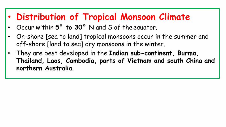
• Distribution of Tropical Monsoon Climate• Occur within 5° to 30° N and S of theequator.
• On-shore [sea to land] tropical monsoons occur in the summer and off-shore [land to sea] dry monsoons in the winter.
• They are best developed in the Indian sub-continent, Burma, Thailand, Laos, Cambodia, parts of Vietnam and south China and northern Australia.


Climate• In the summer, when the sun is overhead at the Tropic of Cancer, a low
pressure is created in Central Asia.
• The seas, which warm up much slower, remain comparatively at high pressure.
• At the same time, the southern hemisphere experiences winter, and a regionof high pressure is set up in the continental interior of Australia.
• Winds blow outwards as the South-East Monsoon, to Java, and after crossing the equator are drawn towards the continental low pressure area reaching the Indian sub-continent as the South-West Monsoon (Coriolis force).
• In the winter, conditions are reversed.

• Temperature• Monthly mean temperatures above 18 °C.
• Temperatures range from 30-45° C in summer. Mean summer temperatureis about 30°C.
• In winters, temperature range is 15-30° C with mean temperature around 20-25° C.

• Precipitation• Annual mean rainfall ranges from 200-250 cm. In some regions it is around
350 cm.
• Places like Cherrapunji & Mawsynram receive an annual rainfallof about 1000 cm.
• They lie on the windward side of the Meghalaya hills, so the resultingorographic lift (orographic rainfall) enhancesprecipitation.


• The Retreating Monsoon• The amount and frequency of rain decreases towards the end of the rainy
season.
• It retreats gradually southwards after mid-September until it leaves the continent altogether.
• The skies are clear again and the cool, dry season returns in October, withthe out blowing North-East Monsoon.
• The role of monsoons in India is vital for its economy.

Tropical Monsoon Forests
• Drought-deciduous forest, dry forest, dry-deciduous forest, tropicaldeciduous forest.
• Broad-leaved hardwood trees. Well developed in southeast Asia.
• Trees are normally deciduous, because of the marked dry period, duringwhich they shed their leaves to withstand the drought [They shed theirleaves to prevent loss water through transpiration].
• The forests are more open and less luxuriant than the equatorial jungleandthere are far fewer species.

Shifting Cultivation
• This most primitive form of farming is widely practiced.
• Instead of rotating the crops in the same field to preserve fertility, thetribesmen move to a new clearing when their first field is exhausted.
• Maize, dry padi, sweet potatoes and some beans are the most common crops.
• Farming is entirely for subsistence i.e. everything is consumed bythefarmer’s family it is not traded or sold.
• As tropical soils are rapidly leached and easily exhausted, the first crop may be bountiful but the subsequent harvests deteriorate.
• Shifting cultivation is so widely practiced amongst indigenous peoples thatdifferent local names are used in different countries.

Region Name of ShiftingCultivation
Malaysia Lacking
Burma Taungya
Thailand Tamrai
Philippines Caingin
Java Humah
Sri Lanka Chena
Africa and CentralAmerica
Milpa
North-east India Jhum

Savanna Climate or Tropical Wet and Dry Climate or Sudan Climate
• This type of climate has alternate wet and dry seasons similar to monsoon climate but has considerably less annual rainfall.
• Also there is no distinct rainy season like in monsoonclimate.
• [Only two seasons – winter and summer Rains occur in summer].
• Floods and droughts are common.
• Vegetation, wildlife and human life are quite different frommonsoon climate regions.

Distribution of Savanna Climate• It is confined within the tropics and is best developed in Sudan, hence its
name the Sudan Climate.
• It is a transitional type of climate found between the equatorial rainforests and hot deserts.
• African Savanna
• The belt includes West African Sudan, and then curves southwards into East Africa and southern Africa north of the Tropic of Capricorn.
• South American Savanna
• There are two distinct regions namely the llanos of the Orinoco basin [northof equator] and the compos of the Brazilian Highlands [South ofequator].

• Australian savanna• The Australian savanna is located south of the monsoon strip (northern
Australia) running from west to east north of the Tropic of Capricorn.
• Indian Savanna• Certain parts across Northern Karnataka, Southern Maharashtra and
Telangana exhibit characteristics of both semi-arid and savanna climate.
• Due to irrigation and cultivation, this region is different from othersavanna regions.


Savanna Climate• Rainfall• Mean annual rainfall ranges from 80 – 160 cm [Rainfall decreases with
distance from equator].
• In the northern hemisphere, the rainy season begins in May and lasts till September.
• In the southern hemisphere, the rainy season is from October to March.

• Temperature• Mean annual temperature is greater than 18° C.
• The monthly temperature hovers between 20° C and 32° C for lowlandstations.
• Highest temperatures do not coincide with the period of the highest sun (e.g. June in the northern hemisphere) but occur just before theonset of the rainy season i.e. April in Northern Hemisphere and October in Southern Hemisphere.
• Days are hot and nights are cold.
• This extreme diurnal range of temperature is anothercharacteristic feature of the Sudan type of climate.

• Winds• The prevailing winds of the region are the Trade Winds, which bring rain to
the coastal districts.
• They are strongest in the summer [favorable position of ITCZ] but are relatively dry by the time they reach the continental interiors or the western coasts [Trade winds are easterlies – flow from east to west. So rainfall decreases from east to west here].
• In West Africa, the North-East Trades, in fact, blow off-shore [continentto sea] from the Sahara Desert and reach the Guinea coast as a dry, dust-laden winds.

• What is the reason for alternating wet and dry seasons in Savanna typeclimate?
• On shore winds is summer bring rains.
• Off-shore winds in winter keep the climate dry.

Natural Vegetation of Savanna Climate
• The savanna landscape is typified by tall grass and short trees.
• The grasslands are also called as ‘bush-veld’.
• The trees are deciduous, shedding their leaves in the cool, dry season to prevent excessive loss of water through transpiration, e.g. acacias.
• Trees usually have broad trunks, with water-storing devices to survive through the prolonged drought..
• In true savanna lands, the grass is tall and coarse, growing 6 to 12 feet high. The elephant grass may attain a height of even 15feet.
.


Life and Economy in the Savanna• Many tribes live in savanna region.
• Tribes like the Masai tribes of the East African plateau are pastoralistswhereas Hausa of northern Nigeria are settledcultivators.
• The old grazing grounds of Masai tribes in the Kenyan Highlands were takenover by the immigrant white settlers for plantation agriculture (coffee, tea,cotton) and dairy farming.
• The cattle kept by the Masai are kept entirely for the supply of milk. Theydon’t slaughter cattle for meat. Agriculture is barely practiced.
• The Hausa are a tribe of settled cultivators who inhabit the savanna lands of the Nigeria. They are more advanced in their civilization.
• They do not practice shifting cultivation. Instead, they clear a piece of landand use it for several years.

Desert Climate• Deserts are regions where evaporation exceeds precipitation.
• There are mainly two types – hot like the hot deserts of the Saharantypeand temperate as are the mid-latitude deserts like theGobi.


Hot Desert Climate• The aridity of the hot deserts is mainly due to the effects of off-shore
Trade Winds, hence they are also called Trade Wind Deserts.• The major hot deserts of the world are located on the western coasts of
continents between latitudes 15° and 30°N. andS• They include the biggest Sahara Desert, Great Australian Desert,
Arabian Desert, Iranian Desert, Thar Desert, Kalahari andNamib Deserts.
• In North America, the desert extends from Mexico into U.S.A. and is called by different names at different places e.g. the Mohave, Sonoran, Californian and Mexican Deserts.
• In South America, the Atacama or Peruvian Desert (rain shadow effect and off-shore trade winds) is the driest of all deserts with less than 2 cm of rainfall annually.


Mid-Latitude Desert Climate• The temperate deserts are rainless because of either continentiality or
rain-shadow effect. [Gobi desert is formed due to continentiality andPatagonian desert due to rain-shadoweffect]
• Amongst the mid-latitude deserts, many are found on plateau and are at aconsiderable distance from the sea.
• These are Ladakh, The Kyzyl Kum, Turkestan, Taklimakan and Gobideserts of Central Asia, drier portions of the Great Basin Desert ofthe western United States and Patagonian Deserts of Argentina etc..
• The Patagonian Desert is more due to its rain-shadow position on theleeward side of the lofty Andes than to continentiality.

Desert Climate• Rainfall (Both Hot and Cold deserts)
• Deserts, whether hot or mid-latitude have an annual precipitation of less than 25 cm.
• Atacama (driest place on earth) has practically no rain at all.
• Rain normally occurs as violent thunderstorms of the convectional type.
• It ‘bursts’ suddenly and pours continuously for a few hours over small areas.

• Major hot deserts in northern hemisphere are located between 20-30degree north and on the western side of the continents. Why?
• The hot deserts lie along the Horse Latitudes or the Sub-Tropical High Pressure Belts where the air is descending, a condition least favorable for precipitation of any kind to take place.
• The rain-bearing Trade Winds blow off-shore and the Westerlies thatareon-shore blow outside the desert limits.
• Whatever winds reach the deserts blow from cooler to warmer regions, and their relative humidity is lowered, making condensation almost impossible.

• On the western coasts, the presence of cold currents gives rise to mists and fogs by chilling the on-coming air. This air is later warmed by contact with the hot land, and little rain falls. T
• he desiccating effect of the cold Peruvian Current along the Chilean coast is so pronounced that the mean annual rainfall for the Atacama Desert is not more than 1.3 cm.


Temperature of Hot deserts• There is no cold season in the hot deserts and the average summer
temperature is high around 30°C.
• The highest temperature recorded is 57.77° C in 1922 at A1 Azizia, Libya.

Desert Vegetation• The predominant vegetation of both hot and mid-latitude deserts is
xerophytic or drought-resistant.
• This includes the cacti, thorny bushes, long-rooted wiry grasses andscattered dwarf acacias.
• Trees are rare except where there is abundant ground water to supportclusters of date palms.
• Along the western coastal deserts washed by cold currents as in theAtacama Desert, support a thin cover of vegetation..

Desert Vegetation• Most desert shrubs have long roots and are well spaced out to gather
moisture, and search for ground water. Plants have few or no leaves and thefoliage is either waxy, leathery, hairy or needle-shaped to reduce the lossof water through transpiration.


Life in the Deserts• Despite its inhospitality, the desert has always been peopled by different groups of inhabitants.
Tribe Desert Occupation
Bedouin Arabs Arabia nomadic herdsmen
Tuaregs Sahara nomadic herdsmen
Gobi Mongols Gobi nomadic herdsmen
Bushmen Kalahari primitive hunters and collectors.
Bindibu Australia primitive hunters and collectors.

Steppe Climate or Temperate Continental Climate or Temperate Grassland Climate
• Distribution• They lie in the interiors of the continents.
• Lie in the Westerly wind belt [mid-latitudes or temperate region].
• Grasslands are practically treeless due to continentiality [deep within theinteriors of the continents where rain bearing winds don’t reach].
• In Eurasia, they are called the Steppes, and stretch eastwards from theshores of the Black Sea to the foothills of the Altai Mountains. [2,000 mileslong belt].

Name oftheTemperate Grassland
Region
Pustaz Hungary and surrounding regions
PrairiesNorth America [between the foothills of the Rockies and the Great Lakes]
Pampas Argentina and Uruguay [Rain-shadow effect]
Bush-veld (moretropical)
Northern South Africa
High Veld (moretemperate)
Southern South Africa
DownsAustralia: Murray-Darling basin of southern Australia
Canterbury New Zealand


Steppe Climate• Temperature
• Temperatures vary greatly between summer and winter.
• The summers are hot and the winters are cold.
• Summers are very warm, over 18 – 20° C.
• The steppe type of climate in the southern hemisphere is never severe.

• Precipitation• The average rainfall may be taken as about 45 cm, but this varies according
to location from 25 cm to 75 cm.
• The heaviest rain comes in June and July (late spring and early summer).
• Most of the winter months have about an 2.5 cm of precipitation, broughtby the occasional depressions of the Westerlies and coming in the form ofsnow.
• The maritime influence in the southern hemisphere causes more rainfall.

Natural Vegetation of Steppe Climate• Grasses• Greatest difference from the tropical savanna is that steppes are
practically treeless and the grasses are much shorter.
• Grasses are tall, fresh and nutritious. This is typical of the grass of thewheat-lands in North America, the rich black earth or chernozem areasof Russian Ukraine and the better watered areas of the AsiaticSteppes.
• Where the rainfall is light or unreliable, or the soil is poor, as in thecontinental interiors of Asia the short steppe type of grass prevails.

• Trees• Polewards, an increase in precipitation gives rise to a transitional zone of
wooded steppes where some conifers gradually appear.
• In recent years, the grasslands have been ploughed up for extensive,mechanized wheat cultivation and are now the ‘granaries of the world’[Prairies].
• The tufted grasses have been replaced by the more nutritious Lucerne oralfalfa grass for cattle and sheeprearing.
• In the cultivated regions, such as the wheat farms of the Prairies, doublerows of trees are planted around the house to shield the occupants from thestrong wind.

• Animals
• Does not have much animal diversity.
• Horses are common in AsianSteppes.

• Nomadic herding in Asian Steppes
• This type of migratory animal grazing has almost disappeared from themajor grasslands.
• The herders were wandering tribes e.g. the Kirghiz, and the Kazakhs.

• Extensive mechanized wheat cultivation• The temperate grasslands are ideal for extensive wheat cultivation.
• The level ness of the Steppes and other temperate grasslands all overtheworld makes ploughing and harvesting a comparatively easy job.
• In the Prairies, the Argentinian Pampas, the Ukrainian Steppes and the Downs of Australia, agriculture is completely mechanized.

• Pastoral farming• The natural conditions suit animal farming.
• With the development of refrigerated ships in the late nineteenth century, the temperate grasslands became major pastoral regions, exporting large quantities of beef, mutton, wool, hides.
• Milk, butter, cheese and other dairy products are also important in someparts of the North American grasslands.

Grassland Major Economic Activity
PrairiesWheat Granaries Extensive Ranching
Pustaz
Rich black soilAbundant wheat productionSugar from Sugar beet [Beta vulgaris,is a plant whose root contains a high concentration of sucrose]Countries like Hungary, Ukraine, Romania etc.
Pampas
Alfalfa: nutrient rich grass.Ranching, cattle rearing; Dairy productsExtensive wheat producing regionEconomy depends on wheat and beef export

Grassland Major Economic Activity
Downs andCanterbury
Sheep and Cattle rearing,Merino sheep: wool production
VeldtsMaize farmsSheep and Cattle rearing

Mediterranean Climate or Warm Temperate Western Margin Climate

• Distribution• Entirely confined to the western portion of continental masses between 30°
and 45° north and south of theequator.
• The basic cause of this type of climate is the shifting of the wind belts.
• Mediterranean Sea has the greatest extent of this type of ‘winter rain climate’ and gives rise to the name MediterraneanClimate.
• The best developed form of this climatic type is found in central Chile.
• Other Mediterranean regions include California (around San Francisco) thesouth-western tip of Africa (around Cape Town), southern Australia, andsouth-west Australia .

Mediterranean Climate• Clear skies and high temperatures; hot, dry summers and cool, wet
winters.
• In summer when the sun is overhead at the Tropic of Cancer, the belt ofinfluence of the Westerlies is shifted a little pole wards.
• Rain bearing winds are therefore not likely to reach the Mediterranean lands.
• The prevailing Trade Winds [tropical easterlies] are off-shore and thereis practically no rain.
• Strong winds from inland desert regions pose the risk of wildfires.

• Rainfall in winter with on-shore Westerlies
• The Mediterranean lands receive most of their precipitation in winter whenthe Westerlies shift equator wards.
• In the northern hemisphere, the prevailing on-shore Westerlies bring much cyclonic rain from the Atlantic

Natural Vegetation in the Mediterranean Climate• Trees with small broad leaves are widely spaced and never very tall.
• The absence of shade is a distinct feature of Mediterraneanlands.
• Plants are in a continuous struggle against heat, dry air, excessiveevaporation and prolonged droughts.
• They are, in short xerophytic [drought tolerant], a word used to describe the drought-resistant plants in an environment deficient in moisture.

Mediterranean evergreen forests• These are open woodlands with evergreen oaks.
• They are found only in the climatically most favored regions.
• The trees are normally low, even stunted, with massive trunks, small leathery leaves and a wide-spreading root system in search of water.
• The cork oaks are specially valued for their thick barks, used for making wine-bottle corks and for export around theworld.

• Evergreen coniferous trees• These include the various kinds of pines, firs, cedars andcypresses
which have evergreen, needle-shaped leaves and tall, straight trunks.
• Mediterranean bushes and shrubs• This is perhaps the most predominant type of Mediterranean vegetation.
• Grass• Conditions in the Mediterranean do not suit grass, because most of the
rain comes in the cool season when growth is slow.

Agriculture in the Mediterranean Climate
• Orchard farming
• The Mediterranean lands are also known as the world’s orchard lands.
• A wide range of citrus fruits such as oranges, lemons, limes, citrons and grapefruit are grown.
• The fruit trees have long roots to draw water from considerable depths during the long summer drought.
• The Mediterranean lands account for 70 per cent of the world’s exports of citrus fruits.
• many nut trees like chestnuts, walnuts, hazelnuts and almonds are grown andthe nuts picked as fruits or for the chocolate industry.

• Wine production• Viticulture is by tradition a Mediterraneanoccupation.
• Regions bordering the Mediterranean Sea account for three-quarters of theworld’s production of wine.
• Some 85 per cent of grapes produced, go into wine.
• The long, sunny summer allows the grapes to ripen.

By Sudarshan Gurjar

By Sudarshan Gurjar

By Sudarshan Gurjar

By Sudarshan Gurjar

By Sudarshan Gurjar

By Sudarshan Gurjar

By Sudarshan Gurjar

By Sudarshan Gurjar

By Sudarshan Gurjar

By Sudarshan Gurjar

By Sudarshan Gurjar

By Sudarshan Gurjar
Warm Temperate Eastern Margin Climate
• Different variants of Warm Temperate Eastern Margin Climate include the
• Temperate monsoon Climate or China Type Climate,
• Gulf Type Climate and
• Natal Type Climate.
• Found between 20° and 35° N and S latitude (warm temperate latitudes just outside the tropics); on the east coast in both hemispheres.

By Sudarshan Gurjar
• China Type Climate• Temperate Monsoon or China Type climate is observed in most parts of China.
The climate is also observed in southern parts of Japan.
• Gulf Type Climate• Found in south-eastern U.S.A., bordering the Gulf of Mexico where
continental heating in summer induces an inflow of air from the coolerAtlantic Ocean.

By Sudarshan Gurjar
• Natal Type Climate• Found in in New South Wales (Australia), Natal (South Africa), Parana-
Paraguay-Uruguay basin (South America).
• Natal type is different from temperate monsoon or China type as it receivesrainfall from on-shore Trade Winds all the year round.

By Sudarshan Gurjar

By Sudarshan Gurjar
Precipitation
• Rainfall is more than moderate, anything from 60 cm to 150 cm.
• This is adequate for all agricultural purposes and hence supports a widerange of crops.
• Areas which experience this climate are very densely populated.
• There is the fairly uniform distribution of rainfall throughout the year.
• Rain comes either from convectional sources or as orographic rain in summer, or from depressions in prolonged showers in winter.
• Local storms, e.g. typhoons (tropical cyclones) and hurricanes, also occur.

By Sudarshan Gurjar
China type climate• Summer
• Intense heating within interiors (Tibet, desert region) sets up a region of lowpressure in summer attracting tropical Pacific air stream (South-EastMonsoon).
• Monsoon does not ‘burst’ as suddenly, nor ‘pour’ as heavily as in India.
• Typhoons form mostly in late summer, from July to September.
• Winter
• There is little rain but considerable snow on the windward slopes.
• Another climatic feature associated with the China type of climate insouthern China is the occurrence of typhoons.

By Sudarshan Gurjar
Natural Vegetation• Supports a luxuriant vegetation.
• The lowlands carry both evergreen broad-leaved forests and deciduous trees [hardwood].
• On the highlands, are various species of conifers such as pines andcypresses which are important softwoods.

By Sudarshan Gurjar
British Type Climate
• Westerlies come all the year round.
• There is a tendency towards an autumn or winter maximum of rainfall.
• Light snow falls in winter.
• Ports are never frozen but frosts do occur on cold nights.
• The seasons are very distinct .
• And the climate is very favorable for maximum human output.
By Sudarshan Gurjar
• British Type Climate or Cool Temperate Western Margin Climate orNorth-West European Maritime Climate.
• The cool temperate western margins are under the influence of the Westerlies all-round the year.
• They are the regions of frontal cyclonic activity [Temperate Cyclones].
• This type of climate is typical to Britain, hence the name ‘British Type’.
• Also called as North-West European Maritime Climate due to greater oceanic influence.

Distribution of British Type Climate
By Sudarshan Gurjar

By Sudarshan Gurjar
Europe• Climatic belt stretches far inland into the lowlands of North-West Europe
(northern and western France, Belgium, the Netherlands, Denmark, western Norway and also north-western Iberia).
• North America
• Confined mainly to the coastlands of British Columbia. [high Rockies prevent the on-shore Westerlies from penetrating far inland]
• Southern Hemisphere
• The climate is experienced in southern Chile, Southern Australia,Tasmania and most parts of New Zealand.

By Sudarshan Gurjar
Precipitation
• The British type of climate has adequate rainfall throughout the year witha tendency towards a slight winter maximum (due to frontal cyclones).
• Western margins have the heaviest rainfall due to westerlies.
• This is particularly significant in New Zealand where the western marginsare subjected to heavy orographic rainfall whereas the eastern Canterburyplains receive comparatively less rainfall due to rain-shadow effect.
By Sudarshan Gurjar
Natural Vegetation in British Type Climate• The natural vegetation of this climatic type is deciduous forest.
• The trees shed their leaves in the cold season.
• This is an adaptation for protecting themselves against the winter snow andfrost.
• Shedding begins in autumn, the ‘fall’ season.
• Some of the common species include oak, elm, ash, birch, beech, and poplar.

By Sudarshan Gurjar
Taiga Climate or Boreal ClimateCool• Boreal Climate OR Taiga Climate OR Siberian Climate OR
Temperate Continental Climate OR Continental Sub-Polar Climate.
• Found only in the northern hemisphere [due to great east-west extent.Absent in the southern hemisphere because of the narrowness in the highlatitudes].
• Experienced in the regions just below Arctic circle.
• On its poleward side, it merges into the Arctic tundra.
• The climate fades into the temperate Steppe climate.

By Sudarshan Gurjar

By Sudarshan Gurjar
• Distribution• It stretches along a continuous belt across central Canada, some parts
of Scandinavian Europe and most of central and southern Russian. [50° to 70° N]
• Absent in Southern Hemisphere• Narrowness of the southern continents in the high latitudes is the main
reason.
• Coniferous forests are found only on the mountainous uplands of southern Chile, New Zealand, Tasmania and south-east Australia.

Taiga Climate
By Sudarshan Gurjar

By Sudarshan Gurjar
with a summer
• Precipitation• Maritime influence in the interiors is absent.
• Frontal disturbances might occur in winter.
• Typical annual precipitation ranges from 38 cm to 63 cm.
• It is quite well distributed throughout the year, maxima [convectional rain in mid-summer – 15 °C to 24 °C]
• In winter the precipitation is in the form of snow, as mean temperatures are well below freezing all the time.

By Sudarshan Gurjar
Natural Vegetation of Taiga Climate• The predominant vegetation is evergreen coniferous forest.
• The conifers, which require little moisture are best suited to this type of sub-Arctic climate.
• The greatest single band of the coniferous forest is the taiga (a Russianword for coniferous forest) in Siberia.
• In Europe the countries that have a similar type of climate and forests are Sweden and Finland.
• There are small amounts of natural coniferous forest in Germany, Poland,Switzerland, Austria and other parts of Europe.
• In North America, the belt stretches from Alaska across Canada intoLabrador.

By Sudarshan Gurjar
Lumbering• This is the most important occupation of the Siberian type ofclimate.
• The vast reserves of coniferous forests provide the basis for the lumberingindustry.
• Lumberjacks: Contract laborers called lumber jacks used to temporarilymove to the forest regions to fell the trees. Now felling is done bymachines.
• Paper and pulp industry: Timber is pulped by both chemical and mechanicalmeans to make wood pulp. Wood pulp is the raw material for paper-makingand newsprint.

By Sudarshan Gurjar
Laurentian Climate or Cool Temperate Eastern Marine Climate
• Intermediate type of climate between the British Type Climate(moderate) and the Taiga Type Climate (extreme)of climate.
• It has features of both the maritime and the continentalclimates.
• Distribution of Laurentian Climate• Laurentian type of climate is found only in two regions and that too only in the
northern hemisphere.

By Sudarshan Gurjar

By Sudarshan Gurjar
• North American region
• North-eastern North America, including eastern Canada, north-eastU.S.A., and Newfoundland.
• This may be referred to as the North American region.
• Asiatic region
• Eastern coastlands of Asia including eastern Siberia, North China, Manchuria, Korea and northern Japan.
• Absent in Southern Hemisphere

By Sudarshan Gurjar
Laurentian Climate• Precipitation• Rainfall occurs throughout the year with summer maxima [easterly winds
from the oceans bring rains]
• Annual rainfall ranges from 75 to 150 cm [two – thirds of rainfall occurs in the summer].
• Dry Westerlies that blow from continental interiors dominatewinters.

By Sudarshan Gurjar
The Asiatic regionJapan
• The climate of Japan is modified by the meeting of warm and cold oceancurrents.
• It receives adequate rainfall from both the South-East Monsoon in summerand the North- West Monsoon in winter (western coasts of Japan)
• The warm Kuroshio makes the climate of Japan lessextreme.
• The meeting zone between warm Kuroshio from south and cold Oyashio fromthe north produce fog and mist, making north Japan a ‘secondNewfoundland’.

By Sudarshan Gurjar
Economic Development – Laurentian Climate• Lumbering and its associated timber, paper and pulp industries arethe
most important economic undertaking.
• Agriculture is less important because of long and severe winters.
• In the North American region, farmers are engaged in dairy farming.
• The Annapolis valley in Nova Scotia is the world’s most renownedregion for apples.
• Fishing is, however, the most outstanding economic activity.

By Sudarshan Gurjar
Fishing off Newfoundland
• Regions around the Grand Banks of Newfoundland are the world’s largestfishing grounds.
• Mixing of warm Gulf Stream and cold Labrador currents make the regionthe most productive fishing ground on earth.
• Fish feed on minute marine organisms called plankton. Plankton isabundantly available in shallow waters [continental shelves] where theyhave access to both sunlight as well as nutrients.
• Also, cold and warm water mixing creates upwelling of cold nutrient richwater to the surface.

By Sudarshan Gurjar
• The gently sloping continental shelves stretch for over 200 miles south-eastof Newfoundland, and off the coasts of the Maritime Provinces and NewEngland.
• Hence microscopic plankton are abundant [Continental Shelf + Mixing ofWarm and Cold Ocean Currents].
• Fish of all types and sizes feed and breed here and support a thrivingfishing industry.
• Along with Canada and U.S.A., countries like Norway, France, Britain,Portugal, Denmark, Russia and Japan, also send fishing fleets to the GrandBanks.
• In Newfoundland, fishing provides employment for almost the entirepopulation.

By Sudarshan Gurjar
• Further inland, in lakes and rivers, such as the St. Lawrence and the GreatLakes, freshwater fish, e.g. salmon etc. are caught.
• All the fishing activities are carried out by highly mechanized trawlerswhich can store fish in refrigerated chambers for months.
• St. John’s, chief port of Newfoundland is the headquarters of the Grand Banks fishing industries.
• All processing activities like cutting, cleaning, packing for disposal are done at the ports itself.
• Over-fishing is a growing problem.

Tundra Climate or Polar Climate or Arctic Climate
By Sudarshan Gurjar

By Sudarshan Gurjar
• Distribution• Found in regions north of the Arctic Circle and south of Antarctic Circle.
• The ice-caps are confined to highlands and high latitude regions ofGreenland and Antarctica.
• In the southern hemisphere, Antarctica is the greatest single stretch of ice-cap (10,000 feet thick).
• The lowlands – coastal strip of Greenland, the barren grounds of northernCanada and Alaska and the Arctic seaboard of Eurasia, have tundra climate.

By Sudarshan Gurjar
Tundra Climate• Temperature
• The tundra climate is characterized by a very low mean annualtemperature.
• In mid-winter temperatures are as low as 40 – 50 °C below freezing.
• Within the Arctic and Antarctic Circles, there are weeks of continuous darkness (Rotation and Revolution).
• The ground remains solidly frozen and is inaccessible to plants.
• Frost occurs at any time and blizzards, reaching a velocity of 130 miles an hour are not infrequent.

By Sudarshan Gurjar
• Precipitation• Precipitation is mainly in the form of snow and sleet.
• Convectional rainfall is generally absent.

By Sudarshan Gurjar
Natural Vegetation – Tundra Climate• There are no trees in thetundra.
• Lowest form of vegetation like mosses, lichens etc. are found here and there.
• Mammals like the wolves, foxes, musk-ox, Arctic hare and lemmings also live in tundra regions.
• Penguins live only in Antarctic regions.

By Sudarshan Gurjar
Human Activities• Human activities of the tundra are largely confined to the coast.
• In Greenland, northern Canada and Alaska live the Eskimos.
• During winter they live in compact igloos.

By Sudarshan Gurjar
Recent Development of the Arctic Region• New settlements have sprung up because of the discovery of minerals.
• Gold is mined in Alaska, petroleum in the Kenai Peninsula, Alaska; and copperat the Rankin Inlet, Canada.
• With the declining reserves of iron ore around the Great Lakes, iron oredeposits in Labrador are gaining importance. New railway lines have beenconstructed to bring the ores to the St. Lawrence River.