Woollybutt 4H & 6H Drilling Campaign · PDF fileWoollybutt 4H & 6H Drilling Campaign Summary...
34
Eni Australia Eni Australia WOOLLYBUTT 4H & 6H WOOLLYBUTT 4H & 6H DRILLING CAMPAIGN SUMMARY ENVIRONMENT PLAN ENI-WA25L-W4H0-BN-0002 SEPTEMBER 2007 Eni Australia Limited Level 3, 40 Kings Park Road, West Perth WA 6005 Tel: +61 8 9320 1111 Fax: +61 8 9320 1100 email: [email protected] This document is the property of Eni Australia Limited Confidentiality shall be maintained at all times. This document will be deemed uncontrolled when printed.
-
Upload
nguyenkhanh -
Category
Documents
-
view
228 -
download
5
Transcript of Woollybutt 4H & 6H Drilling Campaign · PDF fileWoollybutt 4H & 6H Drilling Campaign Summary...

Eni Australia Eni Australia
WOOLLYBUTT 4H & 6H WOOLLYBUTT 4H & 6H DRILLING CAMPAIGN
SUMMARY ENVIRONMENT PLAN
ENI-WA25L-W4H0-BN-0002 SEPTEMBER 2007
Eni Australia Limited Level 3, 40 Kings Park Road,
West Perth WA 6005
Tel: +61 8 9320 1111 Fax: +61 8 9320 1100 email: [email protected]
This document is the property of Eni Australia Limited Confidentiality shall be maintained at all times. This document will be deemed uncontrolled when printed.

Woollybutt 4H & 6H Drilling Campaign Summary Environment Plan
ENI-WA25L-W4H0-BN-0002 September 2007
This document is the property of Eni Australia Limited Confidentiality shall be maintained at all times. This document will be deemed uncontrolled when printed.
Eni Australia
TABLE OF CONTENTS
ABBREVIATIONS....................................................................................................................4
1. INTRODUCTION.............................................................................................................6 1.1 The Operator ......................................................................................................6 1.2 Scope and Objectives of this EP......................................................................6 1.3 External Consultation .......................................................................................6 1.4 Relevant Environment legislation....................................................................7
2. DESCRIPTION OF THE OPERATIONS.........................................................................7 2.1 Field Location ....................................................................................................7 2.2 Current Field Operations ..................................................................................8 2.3 Proposed Drilling Campaign ............................................................................9 2.4 Drilling Support .................................................................................................9
3. DESCRIPTION OF THE ENVIRONMENT......................................................................9 3.1 Climate................................................................................................................9
3.1.1 Temperature...............................................................................................................9 3.1.2 Rainfall .......................................................................................................................9 3.1.3 Wind Patterns...........................................................................................................10
3.2 Oceanography .................................................................................................10 3.3 Turbidity ...........................................................................................................10 3.4 Geomorphology...............................................................................................10 3.5 Biological Environment ..................................................................................11
3.5.1 Regional Distribution Patterns .................................................................................11 3.5.2 Flora and Fauna of the Woollybutt Project Area .....................................................11 3.5.3 Flora and Fauna of Adjoining Sensitive Areas ........................................................12 3.5.4 Sensitive Biological Resources................................................................................13
3.6 Social Environment .........................................................................................13 3.6.1 Shipping ...................................................................................................................14 3.6.2 Commercial Fishing .................................................................................................14 3.6.3 Aquaculture ..............................................................................................................14 3.6.4 Tourism and Recreational Fishing ...........................................................................14 3.6.5 Shipwrecks and Heritage Sites ................................................................................14
4. ENVIRONMENTAL RISK ASSESSMENT ...................................................................15 4.1 Description of General Environmental Risks and their Mitigation .............15 4.2 Environmental Effects and Mitigation Measures for High and Significant
Risks.................................................................................................................26 4.2.1 Drilling chemicals .....................................................................................................26 4.2.2 Atmospheric Emissions............................................................................................26

Woollybutt 4H & 6H Drilling Campaign Summary Environment Plan
ENI-WA25L-W4H0-BN-0002 September 2007
This document is the property of Eni Australia Limited Confidentiality shall be maintained at all times. This document will be deemed uncontrolled when printed.
Eni Australia 4.2.3 Oil and Fuel Spills ....................................................................................................27
5. IMPLEMENTATION STRATEGY .................................................................................29 5.1 Systems, Practices And Procedures .............................................................29
5.1.1 General.....................................................................................................................29 5.1.2 Emergency Response Manual.................................................................................29 5.1.3 OSCP and Resources..............................................................................................29
5.2 Training, Awareness and Competence .........................................................29 5.3 Monitoring, Auditing and Reporting ..............................................................30
5.3.1 Monitoring.................................................................................................................30 5.3.2 Auditing ....................................................................................................................30 5.3.3 Reporting and Recording .........................................................................................30
5.4 Management and Review of the EP ...............................................................30
6. REFERENCES .............................................................................................................31
TABLES
Table 1.1: Woollybutt JVPs ..................................................................................................6 Table 4.1: WB4 and WB6 Drilling: Identified Potential Environmental Risks and Their
Safeguards ........................................................................................................16 Table 4.2: Oil, fuel and chemical spills: identified potential environmental risks and
their safeguards.................................................................................................24
FIGURES
Figure 2.1: Location of Woolybutt Fields and Wells...............................................................8

Woollybutt 4H & 6H Drilling Campaign Summary Environment Plan
ENI-WA25L-W4H0-BN-0002 September 2007
This document is the property of Eni Australia Limited Confidentiality shall be maintained at all times. This document will be deemed uncontrolled when printed.
Eni Australia
ABBREVIATIONS AFM Australian FPSO Management Pty Ltd ALARP As Low As Reasonably Practicable AMOSC Australian Marine Oil Spill Centre AMSA Australian Maritime Safety Authority APPEA Australian Petroleum Production and Exploration Association BoM Bureau of Meteorology BOP Blow-out Preventer DEH Department of the Environment and Heritage DEWR Department of the Environment and Water Resources DoIR Department of Industries and Resources Eni Eni Australia Limited Eni Rep. Eni Representative aboard MODU EP Environment Plan EPBC Act Environment Protection and Biodiversity Conservation Act 1999 FPSO Floating Production, Storage and Offloading Facility HAZID Hazard Identification HAZOP Hazard and Operability HSE Health, Safety and Environment HSEQ Health, Safety, Environment and Quality IRC International Risk Consultants Pty Ltd JVP Joint Venture Partner KCl Potassium Chloride
MARPOL 73/78 International Convention for the Prevention of Pollution from Ships, 1973, as modified by the Protocol of 1978 relating thereto
MD Metres Depth MODU Mobile Offshore Drilling Unit mRT Metres Below Rotary Table MSDS Material Safety Data Sheet nm Nautical Mile NPI National Pollutant Inventory NWP North West Province NWS North West Shelf OIM Offshore Installation Manager OIW Oil in Water OSCP Oil Spill Contingency Plan P(SL)(MoE)R Petroleum (Submerged Lands) (Management of Environment)
Regulations 1999 P(SL)A Petroleum (Submerged Lands) Act 1967 ROV Remotely Operated Vehicle

Woollybutt 4H & 6H Drilling Campaign Summary Environment Plan
ENI-WA25L-W4H0-BN-0002 September 2007
Eni Australia SBM Synthetic Based Mud SCSSV Surface Controled Subsea Safety Valve SG Specific Gravity Songa Offshore Songa Offshore ASA SOPEP Shipboard Oil Pollution Emergency Plan SWR Synthetic/Water Ratio VFPA Vanguard Floating Production (Australia) Pty Ltd VOC Volatile Organic Compound WBM Water Based Mud WA Western Australia WB4 Woollybutt-4H Well WB6 Woollybutt-6H Well WSL Woollybutt South Lobe
This document is the property of Eni Australia Limited Confidentiality shall be maintained at all times. This document will be deemed uncontrolled when printed.

Woollybutt 4H & 6H Drilling Campaign Summary Environment Plan
ENI-WA25L-W4H0-BN-0002 September 2007
Eni Australia
1. INTRODUCTION
1.1 THE OPERATOR
Eni Australia Limited (Eni) is the operator of the Woollybutt field, located approximately 80 km off the north-west coast of Western Australia (WA) in permit WA-25L. Currently, a Floating Production, Storage and Offloading Vessel (FPSO) draws from 3 wells that are tied in using subsea infrastructure.
The Woollybutt facility is operated on a day-to-day basis by Australian FPSO Management Pty Ltd (AFM – formerly known as Vanguard Floating Production (Australia) Pty Ltd (VFPA)), on behalf of Eni. Eni assume overall responsibility for the field, and direct responsibility for the subsurface reservoir management and Offload Tanker operations.
The Joint Venture Partners (JVPs) for the Woollybutt Field development are listed in Table 1.1.
Table 1.1: Woollybutt JVPs
Company Interest in Woollybutt Field Eni Australia Ltd (Field Operator) 65%
Tap West Pty Ltd 15%
Mobil Australia Resources Co Pty Ltd 20%
1.2 SCOPE AND OBJECTIVES OF THE EP AND THIS SUMMARY
This Summary EP is based on the Woollybutt 4H & 6H Drilling Campaign EP (Eni 2007a), submitted and subsequently approved by the Department of Industry and Resources (DoIR) (WA). The drilling campaign commenced in August 2007 and consists of at least one development well, Woollybutt-4H (WB4), as well as an exploration and well test, Woollybutt-6H (WB6). Both WB4 and WB6 will be well tested for approximately 3 days each. Should the well test prove successful for WB6, Eni intends to develop it into a production well. This EP covers the range of outcomes for this campaign.
The overall aim of the EP is to demonstrate to DoIR that Eni has a sound understanding of how its operations interact with the environment and to demonstrate that they have implemented environmental safeguards to reduce the risks to as low as reasonably practicable (ALARP).
1.3 EXTERNAL CONSULTATION
Prior to the initial Woollybutt field developments, extensive consultations have been undertaken with the relevant stakeholders. Relevant stakeholders and their involvement include:
This document is the property of Eni Australia Limited Confidentiality shall be maintained at all times. This document will be deemed uncontrolled when printed. Page 6

Woollybutt 4H & 6H Drilling Campaign Summary Environment Plan
ENI-WA25L-W4H0-BN-0002 September 2007
Eni Australia
• DEWR – Initial EPBC Act, Section 86 Preliminary Documentation. The scope of
this drilling campaign is within the original referral;
• DoIR – Initial and ongoing field developments, HAZID workshops (IRCE 2001);
• Department of Fisheries;
• WAFIC;
• AMOSC; and
• AMSA.
Eni will make itself available for ongoing consultation with relevant government authorities, interested persons or organisations. This will include meetings with DoIR at regular intervals.
Eni has advised the Australian Maritime Safety Authority (AMSA) in advance of the drilling activities to allow appropriate communication to other stakeholders who may use the area (including commercial fisheries). Other requirements for notifying AMSA during a drilling campaign will be followed.
1.4 RELEVANT ENVIRONMENT LEGISLATION
As stated in Eni’s Health, Safety and Environment (HSEQ) policy, Eni is committed to conducting operations in accordance with legislative requirements. Eni will ensure that the drilling campaign complies with all relevant Acts and regulations.
Eni has compiled a database that describes legislation relevant to the environmental management aspects of its operations. The permit area is located in Commonwealth waters and accordingly is subject to Commonwealth jurisdiction.
Eni will review the environmental legislation database annually or when significant environmental legislation changes occur
2. DESCRIPTION OF THE OPERATIONS
2.1 FIELD LOCATION
The Woollybutt Development is located in Commonwealth waters within Permit Area WA-25-L in the Barrow sub-basin on the North West Shelf (NWS) in approximately 100 m water. The field is approximately 40 km west of Barrow Island, 80 km north north west of Onslow, and 190 km west of Dampier Western Australia. Figure 2.1 shows the location of the Woollybutt field and shows WB4 and WB6 in relation to the current Woollybutt wells; Woollybutt-1, Woollybutt-2A and Scalybutt-1.
This document is the property of Eni Australia Limited Confidentiality shall be maintained at all times. This document will be deemed uncontrolled when printed. Page 7

Woollybutt 4H & 6H Drilling Campaign Summary Environment Plan
ENI-WA25L-W4H0-BN-0002 September 2007
Eni Australia
Figure 2.1: Location of Woolybutt Fields and Wells
2.2 CURRENT FIELD OPERATIONS
At present the Woollybutt Field Development consists of three development wells that produce oil, water and associated gas through subsea wellheads and flexible flowlines to an FPSO vessel, the Four Vanguard.
Offtake tankers regularly visit the Four Vanguard to offload oil. The offtake tankers are supported by a static tow to maintain adequate back tension and to prevent potential collision with the Four Vanguard.
This document is the property of Eni Australia Limited Confidentiality shall be maintained at all times. This document will be deemed uncontrolled when printed. Page 8

Woollybutt 4H & 6H Drilling Campaign Summary Environment Plan
ENI-WA25L-W4H0-BN-0002 September 2007
Eni Australia
2.3 PROPOSED DRILLING CAMPAIGN
Commencing July 2007, Eni proposes to drill two new wells as a part of their Woollybutt South Lobe (WSL) development. This involves the development of WB4 and its tie in to the subsea infrastructure as a production well. WB6 will be drilled and tested, evaluated from a production perspective and subsequently completed (similarly to WB4) or plugged and abandoned.
The Songa Venus drill rig is a semi-submersible Mobile Offshore Drilling Unit (MODU) owned and operated by Songa Offshore ASA (Songa Offshore). The drilling campaign will require use of the Songa Venus for approximately 2.5 months.
The wells are to be drilled as a part of the WSL development. WSL is in the same hydrocarbon reservoir and is in pressure communication with the current Woollybutt Field. The campaign will utilise water based muds (WBMs) for upper well sections and synthetic based muds (SBMs) for lower sections. Where practical, a 70/30 SWR (synthetic/water ratio) SBM will be used as drilling fluid.
2.4 DRILLING SUPPORT
The WSL drilling campaign will be supported by two vessels, based in Dampier. They are charged with towing the rig to the location, positioning the rig anchors and supplying the rig with fuel, chemicals, drilling muds, food and water. Eni will ensure that sufficient environmental procedures are in place and that the contractor follows the requirements of this EP.
3. DESCRIPTION OF THE ENVIRONMENT
3.1 CLIMATE
3.1.1 Temperature
The climate of the region is subtropical with moderate winters and very hot summers. Climatic observations have been made at Barrow Island, approximately 40 km to the east of the Woollybutt facility. In summer (December to February), the mean maximum daily temperature recorded is about 34.0˚C and mean daily minimum temperature is 24.5˚C (BoM 2007a). In winter (June to August) mean daily maximum temperatures at Barrow Island are approximately 25.2˚C, while mean daily minimums are approximately 17.5˚C..
3.1.2 Rainfall
Rainfall is low and unpredictable. The highest rainfall occurs during March and June. Average annual rainfall recorded at Barrow Island during the period of records is 315.6 mm (BoM 2007a). Rainfall in summer is often associated with tropical cyclones, which affect the region between November and April. Two tropical cyclones each year could, on average, be expected to affect the Eni facility. However the number of cyclones and their associated rainfall is highly variable between years.
This document is the property of Eni Australia Limited Confidentiality shall be maintained at all times. This document will be deemed uncontrolled when printed. Page 9

Woollybutt 4H & 6H Drilling Campaign Summary Environment Plan
ENI-WA25L-W4H0-BN-0002 September 2007
Eni Australia
3.1.3 Wind Patterns
During October to March, winds are predominantly south westerly or southerly in the morning, tending more westerly in the afternoon. October, November and December generally have the strongest prevailing winds, with wind speeds often in the range 25 to 40 kmh-1. The months of May through to July experience mainly easterly winds, sometimes swinging southerly in the afternoon.
April is a transitional period when the winds are light and variable (mostly less than 20 kmh-1). Wind direction is southerly or south-easterly in the morning, turning either north-easterly or south-westerly in the afternoon. August is the second transitional period of variable winds with directions generally southerly or south-easterly in the morning, with south-westerly or north-easterly winds in the afternoon.
3.2 OCEANOGRAPHY
Water depth of the Woollybutt field is approximately 100 m. To the north west the water deepens gradually across the outer continental shelf before falling more steeply to form the continental slope. To the east the seafloor shallows slowly before rising to form the shoals and islands that include Barrow Island and the Montebello Islands, approximately 40 km away.
The waters that encompass the Woollybutt field lie in the formation area of the Leeuwin Current that flows down the west coast of Western Australia. The source waters for this area extend from the Indonesian Archipelago and across the north of Australia as a result of the Pacific-Indian Ocean Throughflow (CSIRO 2001).
Water temperatures in the vicinity of the Woollybutt site vary due to seasonal conditions and depth. Average monthly sea surface temperatures in the region range from about 24.4˚C in August to 28.4˚C in February (Directorate of Oceanography and Meteorology 2007). Temperatures close to the seafloor will be lower, ranging from 18.5˚C to 29˚C.
3.3 TURBIDITY
The offshore waters in the region of the Woollybutt field are relatively clear. As with most of the waters off WA, the ocean in the region is oligotrophic, with very low nutrient and phytoplankton levels (Pearce 1991, 1997). Turbidity increases in summer, mainly due to the increase in plankton load. However regional scale events, such as flooding associated with cyclonic rainfall, may cause occasional periods of prolonged increase in turbidity.
3.4 GEOMORPHOLOGY
The Woollybutt field is located on the outer part of the continental shelf. A detailed sonar survey of the development area was undertaken in August 2001 to assess bottom conditions in the area. The seabed in the vicinity of the well site slopes gently down towards the west at a gradient of 1:1,000 before dropping away more steeply beyond the western edge of the permit area (Fugro 2001).
This document is the property of Eni Australia Limited Confidentiality shall be maintained at all times. This document will be deemed uncontrolled when printed. Page 10

Woollybutt 4H & 6H Drilling Campaign Summary Environment Plan
ENI-WA25L-W4H0-BN-0002 September 2007
Eni Australia
The seafloor in the vicinity of the well site is comprised of loose fine carbonate silty sand with occasional shell fragments overlying calcarenite at depths of between 1 and 5 m. The geology of the Woollybutt field is expected to comprise an upper Tertiary section of thin sands, marls and carbonates above a lower Cretaceous section, which is primarily shale in its upper area and sandstone inter-bedded with shale at the base of the wells.
3.5 BIOLOGICAL ENVIRONMENT
3.5.1 Regional Distribution Patterns
The outer continental shelf bottom (demersal) habitat that will be affected by the Woollybutt development is predominantly flat and featureless and comprised of loose silty carbonate sands. This habitat is regionally common and the associated flora and fauna widespread. Biological productivity in this environment is low, a function of water depth (50 – 200 m), low nutrient availability and the general absence of hard substrates. Low densities of sponges, gorgonians, ascidians, echinoderms, crustaceans, bryozoans and soft corals are found on hard substrates. Burrowing molluscs, crustaceans and polychaete worms inhabit the sediments, also at low densities.
A range of listed (Threatened and/or Migratory) pelagic and migratory fish, sharks (including whale sharks), turtles and cetaceans (whales and dolphins) are known to pass through the waters in the vicinity of the development site. In particular, the Humpback whale migration route passes through the development area. Migratory seabirds may also overfly the area (DEWR 2007a).
There are a number of reefs, shoals and islands in the broad region in which the development is located. The nearest, Barrow Island, is located approximately 40 km to the east of the Woollybutt field. Shallow sub-tidal and intertidal habitats also occur to the north-east at the Lowendal and Montebello Islands, and to the south at Rosily Island and Serrurier Island.
3.5.2 Flora and Fauna of the Woollybutt Project Area
Benthic Flora and Fauna
Given the depth of water and sedimentary seabed, few benthic resources are expected to be located across the survey area. The depth of water limits the occurrence of algae, seagrasses, corals and some fish and reptile species.
Biota observed on the seafloor in the Woollybutt location included sponges, gorgonians (sea whips and sea fans), soft corals, crinoids (feather stars), ophiuroids (brittle stars), crustaceans (eg hermit crabs) and bryozoans (lace corals). The predominant infauna (animals living within seafloor sediments) recovered from sediment samples were burrowing and tube-dwelling polychaete worms, brittle stars, gastropods, bivalves (molluscs) and amphipods (crustaceans).
This document is the property of Eni Australia Limited Confidentiality shall be maintained at all times. This document will be deemed uncontrolled when printed. Page 11

Woollybutt 4H & 6H Drilling Campaign Summary Environment Plan
ENI-WA25L-W4H0-BN-0002 September 2007
Eni Australia
Mobile fauna observed at the seafloor during ROV surveys (particularly evening surveys) included crustaceans (shrimps, mantis shrimps, hermit crabs) and fish (scorpion fish, dragonets, gobies). A range of other fish and shark species also occur in the area in which the Woollybutt development is located.
Marine Reptiles
Sea snakes and sea turtles are expected to migrate through the Woollybutt development area at certain times during the year. However, the open oceanic conditions of the area mean that there are no features such as feeding or breeding grounds that will result in aggregations of these fauna in the development area.
Marine Mammals
As in the case of marine reptiles, the open oceanic conditions of the study area mean that there are no features such as feeding or breeding grounds that will cause marine mammals to aggregate in the permit area. However, the humpback whale, which migrates annually between summer feeding grounds in Antarctica and winter breeding grounds on the NWS and areas further north, can be expected to pass through the area in significant numbers during its northward and southward migrations. These occur in the vicinity of Woollybutt in winter (June-July) and spring (September-October) respectively (Jenner et al 2001).
Seabirds
The open oceanic conditions of the study area mean that there are no features such as feeding or breeding grounds that will result in concentrations of sea birds. Temporary feeding aggregations may occur at the Woollybutt development.
Some 31 species of sea bird have been recorded on Barrow Island, the nearest site for which such records exist. Many of these species are listed under the JAMBA and CAMBA agreements and it is expected that some individuals of these species would pass through the permit area during their annual migrations and may form temporary feeding aggregations, subject to the availability of food.
3.5.3 Flora and Fauna of Adjoining Sensitive Areas
The nearest sensitive marine habitats in the vicinity of the Woollybutt development are Barrow Island and the Barrow Shoals 40 km to the east, the Lowendal and Montebello Islands more than 40 km to the north-east, and Rosily Island 30 km to the south south-east. Shallow sub-tidal and inter-tidal habitats occur around each of the islands and shoals (URS 2001). Assemblages and species with high conservation and protection significance found in all of these areas are described below.
Seagrasses and Macroalgae
Seagrass habitats are important as a feeding ground for turtles and dugongs, nursery areas for juvenile fish and crustaceans, and as nutrient sinks and sediment traps. Macroalgae form the basis of many food webs in the marine environment and contribute to reef structure and to sediment formation. Algal meadows grow on shallow limestone pavement while seagrass beds are generally located on sandy patches in
This document is the property of Eni Australia Limited Confidentiality shall be maintained at all times. This document will be deemed uncontrolled when printed. Page 12

Woollybutt 4H & 6H Drilling Campaign Summary Environment Plan
ENI-WA25L-W4H0-BN-0002 September 2007
Eni Australia
the lagoons. These habitats occur extensively between and to the east of Barrow Island and the Montebello Islands.
Corals
The islands and shoals have assemblages of reef building corals. Coral reefs are ecologically important due to their high biological productivity and the high diversity and abundance of marine organisms that they support. The shallow offshore limestone reefs support a diverse assemblage of reef forming corals and associated organisms such as fish, invertebrates, seagrasses and macroalgae. Coral reefs occur along the coasts of Barrow Island and the Lowendal and Montebello Islands and in isolated patches between the islands.
Dugongs and Turtles
The shallows surrounding the reefs and islands are feeding grounds for dugong and sea turtles. The adjacent beaches provide nesting sites for green turtles, loggerhead turtles and hawksbill turtles. Turtles use seagrass and algal meadows as feeding areas and nest above the high water mark on sandy beaches. Nesting occurs in summer (September - May) with a peak in December. Hatchlings appear from January to May.
Barrow Island and the Montebello Islands are regarded as two of the most important and remote offshore breeding locations for marine turtles along the north-western Australian coastline.
3.5.4 Sensitive Biological Resources
There are no World Heritage properties, Ramsar wetlands or Commonwealth lands in the Woollybutt development area, nor in adjacent areas potentially affected by the development (DEWR 2007a).
However the development is located within a Commonwealth marine area, and a search of the EPBC Act Erin Database (DEWR 2007a) revealed that there are 50 Listed Marine Species and 26 Whales and Other Cetaceans listed as “may occur” within a 25 km radius of the Woollybutt development. These species may migrate through the permit area to breeding or feeding areas elsewhere. Humpback whales, in particular, are expected to pass through the development area during their annual migrations.
3.6 SOCIAL ENVIRONMENT
The level of human activity in the open ocean in the vicinity of the Woollybutt development is low. Onslow is the nearest mainland town with a population of about 700. A small tourism industry is important in the area, but is mainly oriented towards fishing in the waters near coastal islands and conducted well away from Woollybutt.
Most human activity within the region is associated with the oil and gas industry and general shipping, oil production on offshore and island bases, general cargo shipping, pearl culture in the Montebello Islands and commercial fishing, as described below.
This document is the property of Eni Australia Limited Confidentiality shall be maintained at all times. This document will be deemed uncontrolled when printed. Page 13

Woollybutt 4H & 6H Drilling Campaign Summary Environment Plan
ENI-WA25L-W4H0-BN-0002 September 2007
Eni Australia
3.6.1 Shipping
Most shipping that occurs in the vicinity of Woollybutt is associated with the oil and gas industry. The Woollybutt field is not located near to a major shipping route. The closest major ports to the field are Dampier and Port Hedland to the north-east. It is possible that transient shipping traffic would move though the area en route between southern Australian ports and areas to the north of Australia, however the short temporal duration of the drilling activities are considered to pose a minimal navigational hazard to shipping in the area. The MODU and support vessels are required to report their position to AMSA on a regular basis.
3.6.2 Commercial Fishing
The commercial fisheries that operate in the waters of the NWS are centred in Onslow, 80 km to the south-southeast; Exmouth, 120 km to the southwest, and Dampier, 190 km to the east. The focus of commercial fishing activity is the inner continental shelf and waters surrounding the offshore islands to depths of about 30 m.
3.6.3 Aquaculture
A significant aquaculture industry based on open water culture of the pearl oyster, Pinctada maxima, is located in the sheltered waters of the Montebello Islands.
3.6.4 Tourism and Recreational Fishing
A small tourism industry is in the area, but is oriented towards fishing in the waters near coastal islands. The primary location used is Thevenard Island, which is located about 65 km south-west of the development site. No recreational fishing is known to occur in the deep-water areas around Woollybutt development. However, occasional tourist and fishing charter vessels may pass through the area in transit between Exmouth and the Montebello Islands.
3.6.5 Shipwrecks and Heritage Sites
No heritage sites are known to occur in the vicinity of the Woollybutt development. The DEWR National Shipwreck Database confirms no nearby shipwrecks (DEWR 2007). The nearest wreck is a Tyrall Rocks, approximately 70 km to the north of the development.
This document is the property of Eni Australia Limited Confidentiality shall be maintained at all times. This document will be deemed uncontrolled when printed. Page 14

Woollybutt 4H & 6H Drilling Campaign Summary Environment Plan
ENI-WA25L-W4H0-BN-0002 September 2007
This document is the property of Eni Australia Limited Confidentiality shall be maintained at all times. This document will be deemed uncontrolled when printed. Page 15
Eni Australia
4. ENVIRONMENTAL RISK ASSESSMENT 4.1 DESCRIPTION OF GENERAL ENVIRONMENTAL RISKS AND THEIR MITIGATION
The identified potential environmental risks and their safeguards are presented in Table 4.1. The risks associated with hydrocarbon spills, identified during a separate leak frequency HAZID (IRC 2001) are presented in Table 4.2. The environmental effects and management safeguards for those risks ranked high or significant during the HAZID are described in greater detail in Section 4.2.

Woollybutt 4H & 6H Drilling Campaign Summary Environment Plan
ENI-WA25L-W4H0-BN-0002 September 2007
Eni Australia
Table 4.1: WB4 and WB6 Drilling: Identified Potential Environmental Risks and Their Safeguards
Source of Risk
Potential Environmental
Effects Safeguards or Risk Management Measures
Likelihood of Consequences Being Realised Consequence Risk
Physical Disturbances to Marine Fauna
MODU and support vessel anchoring
Disturbance to benthic marine fauna
• Fauna living in the sediment consisted primarily of low densities of echinoderms (brittle stars), crustaceans and molluscs which are regionally common (URS 2001) .
• Disturbance to these fauna will be spatially localised around the well sites. Each anchoring typically disturbs around 40 m2 of seabed and organisms are expected to recolonise these areas quickly.
• There are no sensitive benthic habitats in the vicinity of the Woollybutt field and the nearest islands and reefs are located over 30 km to the east.
Almost certain Insignificant Low
Noise caused by drilling
Disturbance to cetaceans, turtles, seabirds and fish
• Woollybutt location not in known feeding, breeding or aggregation areas for marine fauna. Typically low densities of fish and seabirds in the oligotrophic waters.
• Expected noise levels (McCauley 1998) are below the guideline threshold, the level of noise that may cause interference to cetaceans of 150 db, published by Environment Australia (DEH 2001).
• The dominant frequencies of drilling are below the hearing range of turtles (100 – 700 Hz).
• An ‘alarm’ response is displayed by turtles approximately 2 km from a seismic survey source (McCauley et al. 2000). The noise intensity of drilling is far less, so the range of disturbance would be decreased. Cetaceans may demonstrate avoidance behaviour from 2 – 8 km away.
• Drilling noise frequencies and intensities (McCauley 1998) are not in the most sensitive range for cetaceans or turtles.
• The relatively constant noise source of drilling is less likely to traumatise fauna than erratic sources.
Unlikely Minor Low
This document is the property of Eni Australia Limited Confidentiality shall be maintained at all times. This document will be deemed uncontrolled when printed. Page 16
Woollybutt 4H & 6H Drilling Campaign Summary Environment Plan
ENI-WA25L-W4H0-BN-0002 September 2007
Eni Australia
Source of Risk
Potential Environmental
Effects Safeguards or Risk Management Measures
Likelihood of Consequences Being Realised Consequence Risk
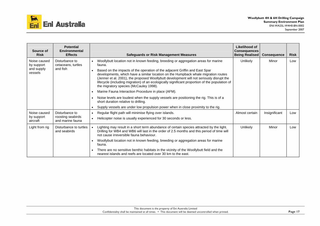
Noise caused by support and supply vessels
Disturbance to cetaceans, turtles and fish
• Woollybutt location not in known feeding, breeding or aggregation areas for marine fauna.
• Based on the impacts of the operation of the adjacent Griffin and East Spar developments, which have a similar location on the Humpback whale migration routes (Jenner et al. 2001), the proposed Woollybutt development will not seriously disrupt the lifecycle (including migration) of an ecologically significant proportion of the population of the migratory species (McCauley 1998).
• Marine Fauna Interaction Procedure in place (AFM).
• Noise levels are loudest when the supply vessels are positioning the rig. This is of a short duration relative to drilling.
• Supply vessels are under low propulsion power when in close proximity to the rig.
Unlikely Minor Low
Noise caused by support aircraft
Disturbance to roosting seabirds and marine fauna
• Regular flight path will minimise flying over islands. • Helicopter noise is usually experienced for 30 seconds or less.
Almost certain Insignificant Low
Light from rig Disturbance to turtles and seabirds
• Lighting may result in a short term abundance of certain species attracted by the light. Drilling for WB4 and WB6 will last in the order of 2.5 months and this period of time will not cause irreversible fauna behaviour.
• Woollybutt location not in known feeding, breeding or aggregation areas for marine fauna.
• There are no sensitive benthic habitats in the vicinity of the Woollybutt field and the nearest islands and reefs are located over 30 km to the east.
Unlikely Minor Low
This document is the property of Eni Australia Limited Confidentiality shall be maintained at all times. This document will be deemed uncontrolled when printed. Page 17

Woollybutt 4H & 6H Drilling Campaign Summary Environment Plan
ENI-WA25L-W4H0-BN-0002 September 2007
Eni Australia
Source of Risk
Potential Environmental
Effects Safeguards or Risk Management Measures
Likelihood of Consequences Being Realised Consequence Risk
Waste Discharges
Drilling chemicals
Disturbance to sensitive environment
Adverse effects on water quality
Smothering of benthic organisms
• Chemicals are reviewed and selected based on technical suitability and by having a minimum overall effect on environment (including ecotoxicity and dosing requirement characteristics).
• Use of drilling chemicals will be minimised as far as is practicable.
• Location remote from sensitive habitats.
• High dilution rates – dilutions of > 1:100 within 20 m of the discharge are predicted during all sea conditions (APASA 2001b).
• Bunded drill floor catches any chemical spills.
Almost certain Moderate Signif-icant
Drill cuttings Increased turbidity in the water column
Smothering of benthic organisms
• The larger particles of the drill cuttings will sink to the sea floor near the MODU and cover the seabed, causing mortality to or displacing benthic organisms. This process occurs slowly and is unavoidable.
• Turbidity in the water column during drilling is caused by the fine cuttings and drilling muds remaining suspended in the water. The turbid plume is minimised by the cuttings shakers equipment aboard the rig.
Almost certain Moderate Signif-icant
This document is the property of Eni Australia Limited Confidentiality shall be maintained at all times. This document will be deemed uncontrolled when printed. Page 18

Woollybutt 4H & 6H Drilling Campaign Summary Environment Plan
ENI-WA25L-W4H0-BN-0002 September 2007
Eni Australia
Source of Risk
Potential Environmental
Effects Safeguards or Risk Management Measures
Likelihood of Consequences Being Realised Consequence Risk
Deck drainage Disturbance to sensitive resources, adverse effects on water quality
• Sealed rig floor drains to a sump.
• Low concentration of contaminants when combined with wash down water.
• Low volumes of overboard discharges involved.
• Localised zone of effect from deck drainage discharge.
• Absorbents and containers will be available on the rig to clean up small accumulations of oil and grease around work areas and decks.
• Process bunding has many times the capacity of the chemical tank volume with the facility to overflow to a main skid bund.
• Oily water from MODU machinery space bilges captured and directed to a sludge tank, which in turn drains into a slops tank.
• The discharge of oily water from machinery spaces in the MODU is regulated by MARPOL 73/78 oil in water requirements.
• Deck areas occasionally washed down with biodegradable industrial detergent such as ‘Rigwash’ to avoid build up of oily contaminants.
Likely Insignificant Low
Laboratory wastes
Disturbance to sensitive resources, adverse effects on water quality
• Oil soluble chemicals will be disposed to the MODU oil storage holds.
• Other laboratory chemicals will be disposed of to hazardous waste containers for transport to the mainland for disposal at approved facilities.
Rare Minor Low
Cooling water Disturbance to sensitive resources, adverse effects on water quality
• High dilution rates would mean that no change in salinity would be detectable outside a localised area.
• Cooling water will be discharged at less than 3 ˚C above ambient sea surface temperature.
Almost Certain Insignificant Low
Reject water Disturbance to sensitive resources, adverse effects on water quality
• Small volumes discharged and high dilution rates would mean that no change in salinity would be detectable outside a localised area.
Almost Certain Insignificant Low
This document is the property of Eni Australia Limited Confidentiality shall be maintained at all times. This document will be deemed uncontrolled when printed. Page 19

Woollybutt 4H & 6H Drilling Campaign Summary Environment Plan
ENI-WA25L-W4H0-BN-0002 September 2007
Eni Australia
Source of Risk
Potential Environmental
Effects Safeguards or Risk Management Measures
Likelihood of Consequences Being Realised Consequence Risk
Waste oil and chemicals
Disturbance to sensitive resources, adverse effects on water quality
• Waste oil and chemicals will be stored aboard the MODU and transferred to the mainland for disposal.
Unlikely Insignificant Low
Sewerage, grey waters and putrescibles wastes
Disturbance to sensitive resources, adverse effects on water quality
Nutrient enrichment and biostimulation of the water column surrounding the MODU
• No sensitive resources in vicinity of Woollybutt location.
• The estimated volume of sewage water produced is 60 L/person/day. Sewage effluent on the MODU will be treated in an extended aeration system and comminuted to pass through a screen of less than 25 mm diameter prior to discharge, in accordance with MARPOL 73/78. The effluent is then discharged directly to the ocean.
• The small volumes of sewage water discharged ensure that only a localised area would be affected by the waste discharge.
• The estimated volume of greywater produced is 140 L/person/day. The small volumes of greywater discharged ensure that only a localised area would be affected by domestic waste discharge.
• Domestic wastes discharged after being macerated to a size less than 25 mm.
• The greywater is comprised of potable water, soap and detergents so none of the identified components of greywater are inherently toxic.
Almost Certain Insignificant Low
This document is the property of Eni Australia Limited Confidentiality shall be maintained at all times. This document will be deemed uncontrolled when printed. Page 20

Woollybutt 4H & 6H Drilling Campaign Summary Environment Plan
ENI-WA25L-W4H0-BN-0002 September 2007
Eni Australia
Source of Risk
Potential Environmental
Effects Safeguards or Risk Management Measures
Likelihood of Consequences Being Realised Consequence Risk
Ballast Water Localised impact on the water column
Introduction of marine pests into WA waters
• Low risk of introduced pests, as the MODU will be towed to the field from the Browse Basin.
• Ballast water exchange procedure in place.
• The MODU ballast water is contained in segregated tanks with dedicated pumping and distribution systems, so is isolated from the crude oil storage tanks, and cannot be polluted with hydrocarbons.
• No chemicals are added or discharged with the ballast water.
Almost certain Insignificant Low
Displacement fluid discharge
Leakage of fluids to environment
• KCl brine will be used as the displacement fluid during drilling.
• Later, during the subsea tie-in, diesel and nitrogen lifting will be used, but all displacement fluids will enter the FPSO and be properly treated.
Unlikely Minor Low
Solid and Hazardous Wastes General rubbish
Disturbance to sensitive resources, adverse effects on water quality
• Transfer of the waste to the mainland for disposal at the Karratha municipal landfill is an appropriate method of disposal and minimises their environmental impacts.
• Selection of offtake tankers and vessels will include a procedure to ensure that they conform to the requirements of MARPOL 73/78 with respect to the handling and disposal of wastes.
• Induction of all personnel.
• Good housekeeping practices.
Unlikely Insignificant Low
This document is the property of Eni Australia Limited Confidentiality shall be maintained at all times. This document will be deemed uncontrolled when printed. Page 21

Woollybutt 4H & 6H Drilling Campaign Summary Environment Plan
ENI-WA25L-W4H0-BN-0002 September 2007
Eni Australia
Source of Risk
Potential Environmental
Effects Safeguards or Risk Management Measures
Likelihood of Consequences Being Realised Consequence Risk
Hazardous wastes
Disturbance to sensitive resources, adverse effects on water quality
• No discharge of solid and/or hazardous wastes from MODU (onshore disposal).
• Wastes stored onboard in appropriate containers.
• Hazardous wastes will be labelled and transferred to the mainland, in accordance with the MSDS instructions.
• Induction of all personnel includes information on waste management procedures.
Unlikely Insignificant Low
Atmospheric Emissions Power generation
Localised effect on air quality
Global contribution to greenhouse gases
• Large quantities of diesel will be combusted for drilling and ship propulsion requirements.
• Localised air quality will suffer a minor, short term decline. • Fuel usage will be minimised through the sound maintenance and tuning of engines. • Many atmospheric emissions are reported through the National Pollution Inventory.
Almost certain Minor Mode-rate
Flared gas Localised effect on air quality
Global contribution to greenhouse gases
• Gas will be flared only during the well testing of WB4 and WB6 and possibly during an emergency.
• Equipment will be maintained to a high standard.
Almost certain Major High
Ozone depleting substances
Localised effect on air quality
• Ozone depleting substances will be avoided wherever possible. Rare Major Mode-rate
Physical Presence Causing Social Disturbances Interference with commercial fishing
Disruption to fishing vessels
Entanglement of trawling equip. (eg nets) on rig anchors or tethers
• Commercial fisheries advised of activity at Woollybutt location (through the rig reporting its position to AMSA and from initial consultation for the facility EP).
• The majority of effort from fisheries is focused inshore of the proposed drilling locations, in waters of depth less than 100 m (trap fisheries generally in less than 50 m of water and trawl fisheries generally in less than 100 m of water).
• A temporary exclusion zone will apply around the MODU. • Navigation lighting and permanent watch aboard the rig and support vessels. • Watch is kept at all times.
Unlikely Minor Low
This document is the property of Eni Australia Limited Confidentiality shall be maintained at all times. This document will be deemed uncontrolled when printed. Page 22

Woollybutt 4H & 6H Drilling Campaign Summary Environment Plan
ENI-WA25L-W4H0-BN-0002 September 2007
Eni Australia
Source of Risk
Potential Environmental
Effects Safeguards or Risk Management Measures
Likelihood of Consequences Being Realised Consequence Risk
Interference with shipping
Disruption to shipping routes
• No major shipping lanes in vicinity of Woollybutt location.
• AMSA notified of location of MODU.
• Navigation lighting and permanent watch aboard the rig and support vessels.
Unlikely Minor Low
Interference with recreational vessels
Disruption to recreational users
• Few recreational vessels utilise this area. Rare Insignificant Low
This document is the property of Eni Australia Limited Confidentiality shall be maintained at all times. This document will be deemed uncontrolled when printed. Page 23

Woollybutt 4H & 6H Drilling Campaign Summary Environment Plan
ENI-WA25L-W4H0-BN-0002 September 2007
Eni Australia
Table 4.2: Oil, fuel and chemical spills: identified potential environmental risks and their safeguards
Release Event Cause
Maximum Spill Size
(L) Safeguards Likelihood Consequence Risk
Loss of well control and blow-out
Well integrity failure Errant vessel collision Well head damage in severe weather
1,000,000 • Test the Blow-out Preventer (BOP) prior to commencement of operations and regularly during operations.
• Pressure test casing strings. • Continuously monitor for abnormal pressure
parameters during drilling. • Ensure the drill crew is fully trained in emergency
well control and Oil Spill Contingency Plan (OSCP) procedures.
• Normal pressure gradients anticipated based on study using nearby well data.
• Designed for 20 tonne snap load. • Surface Controled Subsea Safety Valve (SCSSV). • Exclusion zone. • AMSA aware of well location.
Rare Major Moderate
Leak from fittings and connections
Equipment failure Negligible • SCSSV. • Pressure tested equipment. • Pressure low switch on flowlines. • Detailed HAZOP.
Unlikely Insignificant Low
This document is the property of Eni Australia Limited Confidentiality shall be maintained at all times. This document will be deemed uncontrolled when printed. Page 24

Woollybutt 4H & 6H Drilling Campaign Summary Environment Plan
ENI-WA25L-W4H0-BN-0002 September 2007
This document is the property of Eni Australia Limited Confidentiality shall be maintained at all times. This document will be deemed uncontrolled when printed. Page 25
Eni Australia
Release Event Cause
Maximum Spill Size
(L) Safeguards Likelihood Consequence Risk
Refuelling incident Localised and temporary acute and chronic toxic effects to sensitive resources Adverse effects on water quality
2,500 • Refuelling will be undertaken only during periods of calm weather and in daylight hours.
• Transfer hoses will be fitted with ‘dry break’ couplings.
• Refuelling operations will be overseen by the vessel’s Master or First Officer.
Possible Moderate Moderate
Vessel collision Localised and temporary acute and chronic toxic effects to sensitive resources Adverse effects on water quality
80,000 • Hydrocarbons (ie. diesel) likely to have high evaporation and dispersion rates in NWS waters.
• No sensitive resources permanent in area, spill unlikely to reach shorelines.
• MODU OSCP. • AMSA aware of location of MODU.
Rare Major Moderate
Leaks of hydraulic fluids
Localised and temporary acute and chronic toxic effects to sensitive resources
Adverse effects on water quality
50 • Preventative maintenance. • Manned operation (visual detection of release). • Drip pans/bunds.
Unlikely Insignificant Low
Chemical spills Spills during transfers eg dropped bulk bin Spills during storage and handling
1,000 • Transfers will be undertaken only during periods of calm weather and in daylight hours.
• Transfer operations will be overseen by the vessel’s Master or First Officer.
Unlikely Moderate Moderate

Woollybutt 4H & 6H Drilling Campaign Summary Environment Plan
ENI-WA25L-W4H0-BN-0002 September 2007
This document is the property of Eni Australia Limited Confidentiality shall be maintained at all times. This document will be deemed uncontrolled when printed.
Eni Australia
Page 26
4.2 ENVIRONMENTAL EFFECTS AND MITIGATION MEASURES FOR HIGH AND SIGNIFICANT RISKS
4.2.1 Drilling chemicals
It is proposed to use WBMs for the top sections. WBMs will consist of a KCL/Polymer base (as previously used at the Woollybutt location), which has been used widely in the NWS. These fluids have low toxicities, degrade rapidly in the marine environment and are routinely accepted for use by the regulatory authorities (Hinwood et al. 1994).
Eni is satisfied that with continuous management and optimisation of chemical injection rates, the residual chemicals in the water discharged overboard can be maintained to ALARP. Other NWS drilling operations use the same chemical supplier and achieve a satisfactory environmental performance.
4.2.2 Atmospheric Emissions
Given the short duration of the drilling campaign, there are no specific methods to reduce atmospheric emissions. Eni have made commitments at the front of this EP to maintain all machinery and engines in good mechanical order, thereby maximising fuel efficiency and reducing emissions.
Flared well fluids
The flaring of well test formation gases will release mostly carbon dioxide (CO2) into the atmosphere. Smaller quantities of other gases, such as oxides of nitrogen (NOx) and carbon monoxide (CO) will also be generated, with minimal quantities of sulphur dioxide (SO2), owing to the low sulphur content of the formation oil.
Exhaust gases
As with well test emission, exhaust gases will be produced from running the power generation equipment, namely diesel engines. The composition of exhaust gases varies slightly from the well test flaring, but the primary constituent remains CO2.
Other emissions
Processing and sampling of the well stream fluids during well testing will lead to some fugitive atmospheric emissions. These emissions will mostly be associated gas from the reservoir. Based on standard industry figures, the maximum volume of compressed gas that may escape from worn seals is 2% (Eni 2006). The MODU has undergone recent maintenance and upgrades.
The storage of crude oil for sampling results in the evolution of vapours and gases as light ends (low molecular weight compounds) being volatised. Venting of these storage tanks may be necessary for safety reasons and when the storage tanks are being filled. The principal component of vent gas is volatile organic compounds (VOCs). VOCs are greenhouse gases emitted in very small quantities during well testing.

Woollybutt 4H & 6H Drilling Campaign Summary Environment Plan
ENI-WA25L-W4H0-BN-0002 September 2007
This document is the property of Eni Australia Limited Confidentiality shall be maintained at all times. This document will be deemed uncontrolled when printed.
Eni Australia
Page 27
No adverse environmental impacts are expected from the unavoidable venting to atmosphere of VOCs, apart from a minor and unavoidable contribution to the release of greenhouse gases.
4.2.3 Oil and Fuel Spills
During the drilling of the WB4 and WB6 wells there is the potential for oil of the following types to be spilt:
1. lubricants/hydraulic fluids (rarely spilt, small quantities only);
2. diesel fuel; and
3. formation crude.
Potential sources, volumes and risk of an oil spill
Eni commissioned International Risk Consultants Pty Ltd (IRC) to undertake a HAZID workshop to identify potential events for hydrocarbon release during development (drilling and installation of flowlines), production and decommissioning (IRC 2001). The results from this exercise found that proposed operational controls would render such events as rare or unlikely.
Diesel release from MODU due to impact
The likelihood of vessel collision is rare. However, should such an event occur, it is estimated that a maximum of 80 m3 of diesel could be released from the MODU. Safeguards to prevent this occurring are the use of approved safety procedures during positioning of the MODU, and AMSA being aware of MODU location.
Diesel release during transfer
Spills caused by fuel handling mishaps are rare, but because of the number of times fuel is handled at sea and the volumes involved, this is one of more common sources of spills. Causes include hose rupture, coupling failures, and tank overflow. The likely maximum volume of fuel spilt as a result of one of these events has been estimated at 2.5 m3. Quantities are minimised by shutdown of pumps and automatic closure of safety valves. Rupture of a fuel transfer hose typically leads to a spill of no more than 0.2 m3.
Leak of hydraulic fluid from hoses/pipe work in derricks
Leaks of hydraulic fluids from hoses or pipework in derricks could occur sometime during the project but is unlikely to due to the safeguards in place: preventative maintenance, manned operations and the presence of drip pans/bunds. Should such an event occur, spill volumes of hydraulic fluid would be very small.

Woollybutt 4H & 6H Drilling Campaign Summary Environment Plan
ENI-WA25L-W4H0-BN-0002 September 2007
This document is the property of Eni Australia Limited Confidentiality shall be maintained at all times. This document will be deemed uncontrolled when printed.
Eni Australia
Page 28
Blow-outs
The presence of shallow gas pockets can cause a kick, which increases the chances of a blowout. However, no shallow gas has been encountered in previous drilling. Should a blow-out occur, the volume spilled will depend on the permeability of the producing formation, the thickness of the encountered producing interval, the viscosity of the oil, the number and type of obstructions in the well hole, and the time taken to regain control and seal off the well bore. . The maximum volume of oil that could be released has been estimated at 1,000 m3.
Well testing
There will be no drill string testing. Only wire-line pre-tests and sampling will be performed based on the presence of hydrocarbons. This eliminates the risk of accidental releases of hydrocarbons during well testing operations.
Release from a general support vessel
Release from a general support vessel incident (ie. vessel collision) is highly unlikely. Credible worst case volumes lost under this scenario would be up to 80 m3 of diesel, which would have a generic leak frequency assessment estimated at approximately 1.1 x 10⁻⁶ (Apache 2001).
Oil Spill Modelling
Oil spill modelling for the Woollybutt Field was commissioned by Eni to assess the risk for oil to be transported from the production site to surrounding shorelines (APASA 2001b). The FPSO mooring site was used as the spill location. This is considered representative of all operational sites within the area due to the proximity of the well sites to the FPSO location, and the large distance to the nearest islands.
The results of the modelling indicate that, during the transition months (April and September), south westerly winds are relatively common, resulting in oil being transported in the direction of the islands to the east and north east of Woollybutt, but wind strengths are lower. The probability of contact is less than 10 % and the minimum time before exposure of the nearest island Barrow Island would be over 50 hours.
During winter (May to August) winds are predominantly from the east resulting in negligible exposure to the islands. Any spill would be transported parallel to the coast towards the west and away from any sensitive areas.
Oil Spill Contingency Plan (OSCP)
An updated OSCP (Eni 2007b, ENI-WA25L-0000-PQ-0001, Rev 5) has been submitted and approved by DoIR in accordance with the requirements of Section 14(8) of the P(SL)(MoE)R 1999. Included in the OSCP is a report on the weathering characteristics of Woollybutt crude and its amenability to dispersant application (Geotech 2002). This report has been used to validate whether the response strategies identified in the OSCP are appropriate.

Woollybutt 4H & 6H Drilling Campaign Summary Environment Plan
ENI-WA25L-W4H0-BN-0002 September 2007
This document is the property of Eni Australia Limited Confidentiality shall be maintained at all times. This document will be deemed uncontrolled when printed.
Eni Australia
Page 29
Given the location of the field in most instances it is anticipated that the environmentally preferred strategy will be to allow the spilled oil to weather naturally until it disappears. During this weathering period the slick’s location will be regularly monitored and the need for intervention assessed. The time required for a slick to reach the nearest islands will provide sufficient time for the appropriate response to be determined and implemented.
5. IMPLEMENTATION STRATEGY
5.1 SYSTEMS, PRACTICES AND PROCEDURES
5.1.1 General
As the Operator, Eni will ensure that its personnel and contractors comply with all regulatory controls under the P(SL)A, EPBC Act, the EP (Eni 2007a) and other relevant legislation
Other key aspects of Eni’s environmental management strategies include:
• HSE Management System (Eni 2001a) and supporting documentation, including the HSE Project Plan (Eni 2001b), Eni OSCP (Eni 2007b) and the drilling contractor’s Emergency Response Plan and Emergency Management Plan;
• Use of the Songa Venus MODU and drilling programme with previous proven success on the NWS environment;
• Use of personnel with local area experience; and
• Compliance with the APPEA Code of Environmental Practice.
5.1.2 Emergency Response Manual
Eni has supplied an up-to-date emergency response manual (including an OSCP) that includes detailed response and investigative arrangements.
5.1.3 OSCP and Resources
Oil spill emergency will be managed in accordance with the Eni OSCP (Eni 2007b, ENI-WA-25L-0000-PQ-0001 Rev 5). Equipment can be sourced locally through the Australian Institute of Petroleum Regional Industrial Controller and through the Australian Marine Oil Spill Centre (AMOSC) in Geelong, Victoria. Eni, as a member of AMOSC, has priority access to equipment and training. .
5.2 TRAINING, AWARENESS AND COMPETENCE
Contractors and staff will receive appropriate training on their environmental responsibilities in connection with the WSL drilling campaign. All Eni and contractor personnel will receive an environmental induction. The induction will follow induction procedures (Eni 2001c) and address the issues and actions identified within this EP.

Woollybutt 4H & 6H Drilling Campaign Summary Environment Plan
ENI-WA25L-W4H0-BN-0002 September 2007
This document is the property of Eni Australia Limited Confidentiality shall be maintained at all times. This document will be deemed uncontrolled when printed.
Eni Australia
Page 30
5.3 MONITORING, AUDITING AND REPORTING
5.3.1 Monitoring
The Eni representative will conduct an environmental inspection audit during drilling operations to ensure compliance with the performance standards in detailed in Table 5.1 of the EP (Eni 2007a). The results of the inspection will be a trigger to review the EP and ensure that any deficiencies are incorporated into the planning of future drilling programmes. Any significant incidents occurring during the drilling will also trigger a review of the EP.
Record keeping of emissions and discharges will be in compliance with the requirements of the P(SL)(MoE) Regulations 1999.
5.3.2 Auditing
Audits of the MODU will be conducted against the environmental performance objectives detailed in Table 5.1 of the EP (Eni 2007a) to ensure effective legislative compliance and management of the high and significant risks. A report will be produced and non-conformances will be incorporated into the current and future campaigns.
5.3.3 Reporting and Recording
DoIR will be notified of all reportable incidents, according to the requirements of Regulation 26 of the P(SL)(MoE)R 1999. Eni, as operator of the Woollybutt field will provide written reports on any reportable incidents to DoIR. Eni will keep a record of reports for each reportable incident, and of the details, in each case, of any corrective action taken.
5.4 MANAGEMENT AND REVIEW OF THE EP
This EP will be reviewed:
• when an environmental audit of the drilling campaign finds significant breaches of the EP requirements; or
• if any significant new environmental risk or effect, or significant increase in an existing environmental risk or effect occurs that is not provided for in the existing environment plan.
Any significant incident occurring during operations would also trigger a review of the EP.

Woollybutt 4H & 6H Drilling Campaign Summary Environment Plan
ENI-WA25L-W4H0-BN-0002 September 2007
This document is the property of Eni Australia Limited Confidentiality shall be maintained at all times. This document will be deemed uncontrolled when printed.
Eni Australia
Page 31
6. REFERENCES
ANZECC (1998). Interim Marine and Coastal Regionalisation for Australia: an Ecosystem-based Classification for Marine and Coastal Environments, Imcra Technical Group, Australian and New Zealand Environment and Conservation Council, Australia.
ANZECC (2000). Australian and New Zealand Guidelines for Fresh and Marine Water Quality. Http://www.mincos.gov.au/pub_anzwq.html (accessed august 2006) Australian and New Zealand Environment Conservation Council (ANZECC) and Agriculture and Resource Management Council of Australia and New Zealand (ARMCANZ), Canberra.
Apache Energy (2001). Simpson Development: Public Environmental Report, April 2001. Perth, Western Australia. Report number: EA-60-R1-110. l
APASA (2001a). An Assessment of the Risk of Exposure to Surrounding Locations from Hypothetical Oil Spills from the Proposed Woollybutt FPSO and Production Site. November 2001. Unpublished report prepared by APASA for Eni, Perth, Western Australia.
APASA (2001b). Modelling the Expected Concentrations of Total Hydrocarbons Found Within the Woollybutt Plume. November 2001. Unpublished report prepared by APASA for Eni, Perth.
BOM (2007a). Averages for Barrow Island, Bureau of Meteorology, Canberra, ACT. Online: http://www.bom.gov.au/climate/averages/tables/cw_005058.shtml
BOM (2007b). Tide Predictions for Western Australia, Bureau of Meteorology, Canberra, ACT. Online: http://www.bom.gov.au/oceanography/tides/maps/tanker.shtml#form
CSIRO (2001). The Leeuwin Current – Life of the West Fact Sheet No. 44 August 2001, CSIRO Marine Research, Hobart, TAS. Online: http://www.marine.csiro.au/leafletsfolder/pdfsheets/44.pdf
DEH (2001). Guidelines on the Application of the Environment Protection and Biodiversity Conservation Act to Interactions Between Offshore Seismic Operations and Larger Cetaceans. Environment Australia (Department of the Environment and Heritage), Canberra.
DEH (2005). Emission Estimation Technique Manual for Oil & Gas Exploration & Production National Pollutant Inventory, Department of the Environment and Heritage, Canberra, ACT. http://www.npi.gov.au/handbooks/approved_handbooks/pubs/foilgas.pdf
DEWR (2007). National Shipwreck Database, Department of the Environment and Water Resources, Canberra, ACT. Accessed: 22 March 2007. http://eied.deh.gov.au/nsd/public/search_latlon.cfm
DEWR (2007a). Protected Matters Search Tool, Department of the Environment and Water Resources, Canberra, ACT. Accessed: 22 march 2007. http://www.environment.gov.au/erin/ert/epbc/index.html
Directorate of Oceanography and Meteorology (2007). Surface Temperature Search Tool Directorate of Oceanography and Meteorology, Royal Australian Navy, Garden Island, Sydney, NSW. http://www.metoc.gov.au/products/data/aussst.php
Eni (2001a). Woollybutt Development HSE Management System Procedure. Document reference W00-IN-PQ-0018. Perth.
Eni (2001b). Woollybutt Development Project HSE Plan. Document reference W00-IN-PQ-0019. Perth.
Eni (2000b). Woollybutt Development Cetacean Interaction Procedure. Document reference W00-IN-PQ-0090. Perth.
Eni (2001c). Woollybutt Development Induction Procedure. Document reference W00-IN-PQ-0007. Perth.

Woollybutt 4H & 6H Drilling Campaign Summary Environment Plan
ENI-WA25L-W4H0-BN-0002 September 2007
This document is the property of Eni Australia Limited Confidentiality shall be maintained at all times. This document will be deemed uncontrolled when printed.
Eni Australia
Page 32
Eni (2001d). Woollybutt Development Incident Reporting and Investigating. Document reference W00-IN-PQ-0031. Perth.
Eni (2001f). Woollybutt development hazard and risk register. Document reference W00-IN-PQ-0033. Perth.
Eni (2001g). Woollybutt Development Hazard Identification and Risk Assessment. Document reference W00-IN-PQ-0034. Perth.
Eni (2001e). Woollybutt Development Audit and Review. Document reference W00-IN-PQ-0037. Perth.
Eni (2002a). Woollybutt Field Development Facility Environment Plan. Document reference Eni-W00-IN-PQ-0022. Eni, Perth.
Eni (2002b). Woollybutt Field Development Production Drilling Environment Plan. Document reference Eni-W00-IN-PQ-0017. Eni, Perth.
Eni (2004a). Application to Drill Scalybutt-1 (WA-25-L) Part 2 Drilling Programme (Preliminary. Document reference Eni-WA25L-0002-RD-0101 Rev. A. Eni, Perth.
Eni (2006). Woollybutt Field Environment Plan, July 2006. Document reference, ENI-0000-PF-502, Rev 5, Eni, Perth.
Eni (2007a). Woollybutt 4H & 6H Drilling Campaign Environment Plan. Document reference, ENI-WA25L-W4H0-BN-0001, Rev 0. Eni, Perth.
Eni (2007b). Woollybutt Development Oil Spill Contingency Plan. Document reference, ENI-WA25L-0000-PQ-0001, Rev 5. Eni, Perth.
Fugro (2001). Woollybutt Project – Permit WA-234-P Geophysical Investigation Final Survey Report Volume 1 – Text and Appendices. Report prepared for Eni Australia Limited by Fugro Survey Pty Ltd, Perth Western Australia. Document number HY 16434.
Geotech (2002). Laboratory Scale Weathering and Dispersability of Oil. Report prepared for Eni Australia Limited by Geotechnical Services Pty Ltd, Perth Western Australia. Document number ENV 02-228.
Heyward, A. J. and Smith, l. D. (1996). Analysis of Timor Sea Macrobenthos from ROV Video – Bayu-Undan. Produced at the request of BHP Petroleum Pty. Ltd. By the Australian Institute of Marine Science, Dampier, Western Australia: in Leprovost Dames and Moore (1997), Appendix C.
Hinwood, J. B., Potts A.E., Dennis, l. R., Carey, J. M., Houridis, H., Bell, R. J., Thompson, J. R., Boudreau, P. & Ayling, D.M. (1994). Environmental Implications of Offshore Oil and Gas Development in Australia – Drilling Activities. In Swan, J. M., neff, J. M. & Young, P. C. (eds). Environmental Implications of Offshore Oil and Gas Development in Australia – the Findings of an Independent Scientific Review. Australian Petroleum Exploration Association (APEA) and Energy Research and Development Corporation (ERDC). Sydney.
Holloway, P.E., Humphries, S.E., Atkinson, M. And Imberger, J. (1985). “Mechanisms for Nitrogen Supply to the Australian North West Shelf”. Australian Journal of Marine and Freshwater Research, 36(6):753–764.
IRC (2001). Woolybutt Development. Hydrocarbon Release Identification Workshop. October 2001. RS-REP-01-188-001 Rev 1. Unpublished Report prepared by IRC for Eni, Perth, Western Australia.
IRCE (2001). Proposed Woollybutt Development Preliminary Information for Environment Australia. Unpublished Report Prepared by IRC Environment for Eni, Perth, Western Australia. Report: E-REP-01-188-003 Rev 2.

Woollybutt 4H & 6H Drilling Campaign Summary Environment Plan
ENI-WA25L-W4H0-BN-0002 September 2007
This document is the property of Eni Australia Limited Confidentiality shall be maintained at all times. This document will be deemed uncontrolled when printed.
Eni Australia
Page 33
IRCE (2002). Woollybutt Field Development. Environmental HAZID. Unpublished Report prepared by IRC Environment for Eni, Perth, Western Australia. Report: E-REP-01-188-011 REV 0.
Jenner, C., Jenner, M N. And McCabe, K. (2001). Geographical and Temporal Movements of Humpback Whales in Western Australian Waters – a Preliminary Report and Description of a Computer Assisted Matching System. Centre for Whale Research (Western Australia) Inc., Fremantle.
Jones, H. E. (1986). Marine Resources Map of Western Australia. Part I, the Resources; and Part 2, the Influence of Oil on the Marine Resources and Associated Activities with an Emphasis on those found in Western Australia. Western Australian Department of Fisheries Report No. 74, Fisheries Department, Perth, Western Australia.
Kagi, R. I., Fisher, S. J. & Alexander, R. (1988). Behaviour of Petroleum in Northern Australian waters. In: Purcell, R. G. & Purcell, R. R. (eds), the North West Shelf Australia Proceeding, North West Shelf Symposium. Perth, Western Australia. Petroleum Exploration Society of Australia Limited.
LDM (1997). Environmental Management Plan for the Drilling of Woollybutt-2 and-3, WA-234-P. Report prepared for Hardy Petroleum Limited by Leprovost Dames & Moore, Perth. Report No. R649.
LDM (1998). WA-271-P Resource Atlas, Unpublished report prepared for Woodside Energy Ltd. By Leprovost Dames and Moore, Perth, Western Australia
LDM (2000). Environment Plan for the Drilling of Corkybark-1, WA-234-P. Report prepared for British Borneo Australia Limited by Leprovost Dames & Moore, Perth, Western Australia. Report No. R743.
McCauley, R. (1998). Radiated Underwater Noise Measured from the Drilling Rig Ocean General, Rig Tenders Pacific Ariki and Pacific Frontier, Fishing Vessel Reef Venture and Natural Sources in the Timor Sea, Northern Australia. Report prepared for Shell Australia, Melbourne, July 1998.
McCauley, R. D., Fewtrell, J., Duncan, A. J., Jenner, C., Jenner, M-N., Penrose, J. D., Prince, R. I. T., Adhitya, A., Murdoch, J. And McCabe, K. (2000). Marine Seismic Surveys – a study of environmental implications. APPEA Journal 2000, pp. 692.
Pearce, A. F. (1991). Eastern Boundary Currents of the Southern Hemisphere. Journal of the Royal Society of Western Australia 74:35-45.
Pearce, A. F. (1997). The Leeuwin Current and the Houtman Abrolhos Islands. In: Wells, F. E. (ed) the Marine Flora and Fauna of the Houtman Abrolhos Islands, Western Australia.
Swan, J.M., Neff, J.M. & Young, P.C. (eds.) (1994). Environmental Implications of Offshore Oil and Gas Development in Australia, the Findings of an Independent Scientific Review. Australian Petroleum Exploration Association (APEA), Energy Research and Development Corporation (ERDC), Australia.
URS (2001). Woollybutt Field Development Environmental Field Investigation (draft). Report to Eni Australia Limited by URS, Perth, Western Australia. Document number WIN-0000-RN-0001.
Wells, F.E. (1980). The Distribution of Shallow-Water Marine Prosobranch Gastropod Molluscs Along the Coastline of Western Australia. Veliger 22: 232–247.
Wells, F.E. (1997). Shallow Water Marine Gastropods Endemic to Western Australia. Haliotis 26: 73–80.
Wilson, B.R. & Allen, G. (1987). Major Components and Distribution of Marine Fauna. In: Fauna of Australia, Vol 1a - General Articles. Australian Government Publishing Service, Canberra 1987.
Wilson, B.R. And Gillett, K. (1971). Australian Shells. A.H. & A.W. Reed, Sydney