Winter Weather Basics: Cold Air Outbreaks Basics of...Winter Weather Basics: Cold Air Outbreaks...
28
Winter Weather Basics: Cold Air Outbreaks Or…”Exactly why is it so cold out there?” 2014 Winter Talk Series National Weather Service Gaylord, MI
Transcript of Winter Weather Basics: Cold Air Outbreaks Basics of...Winter Weather Basics: Cold Air Outbreaks...

Winter Weather Basics: Cold Air Outbreaks
Or…”Exactly why is it so cold out there?”
2014 Winter Talk Series National Weather Service Gaylord, MI

As meteorologists…we tend to have a bad habit of getting into “geek speak” when we try to explain weather to the public or media. This was especially true last winter with the heavy media attention given to the persistent outbreaks of cold air.
Talk of ridges and troughs, jet streams and fronts, and other technical jargon sounds simple to us, but usually flies over the heads of casual observers.
So we thought it might be helpful to explain some of these terms, and how they come together to produce prolonged periods of frigid weather.

Atmospheric Flow: Troughs…Ridges…and Jet Streams
Let’s start by talking about the jet stream and its importance in driving our day-to-day weather.
Differences in solar heating across the globe (more at the Equator…less at the poles), result in a contrast in temperature from north (cold) to south (warm) between the poles and the equator.
What we call “weather” is a result of the atmosphere simply trying to redistribute this excess heat from the Equator toward the poles.

Atmospheric Flow: Non Rotating Earth

But the rotation of the Earth complicates this simple circulation of warm air moving north and cold air pushing south (in the Northern Hemisphere).
The tendency is then toward something of a “collision” between these cold and warm air masses, which actually focuses these temperature differences across a smaller area.
Atmospheric Flow: Troughs…Ridges…and Jet Streams
These contrasting air masses often meet in the middle latitudes, where the United States happens to reside.
Global cloud circulation

Atmospheric Flow: Troughs…Ridges…and Jet Streams
The difference in temperature over a given distance is what we call a temperature gradient. The larger the temperature contrast over a given distance, the stronger the gradient is. Temperature gradients often contain areas of significant weather.
15F
70F
60F
75F
Strong Gradient
Weak Gradient

Areas of strong temperature gradients are also regions of sharp changes in air pressure over a given difference...which is called a pressure gradient.
Pressure gradients are what causes the wind to blow...driving air flow from higher toward lower pressure. A stronger pressure gradient results in a stronger wind speed.
Atmospheric Flow: Troughs…Ridges…and Jet Streams
These strong temperature contrasts are what give rise to the jet stream...which is essentially a fast (often >100mph during winter) ribbon of winds at high levels of the atmosphere (typically above 25,000 feet)...and mostly circles the globe (though wind strength varies).
Orange/Red Shading: Stronger Winds
Cold
Warm
The jet stream is the “dividing line” separating colder and warmer air masses.

The strength of the jet stream is greater during the cool season given the greater temperature contrasts from north to south (think Michigan versus Florida in January).
But the jet stream usually doesn’t flow directly from west to east...it has a tendency to meander...the result of the atmosphere trying to transport warm air north and cold air south.
Atmospheric Flow: Troughs…Ridges…and Jet Streams
These “wobbles” take the form of waves in the upper levels of the atmosphere...with areas of low pressure referred to as troughs and higher pressure with ridges.

Since cold air is more dense than warm air...cold air masses are associated with lower pressure at a given height in upper levels of the atmosphere (think of the atmosphere being compressed).
So troughs in the upper level wind pattern are associated with cold air masses, and ridges with warm air masses.
Atmospheric Flow: Troughs…Ridges…and Jet Streams
Cold air outbreaks are associated with a strong trough in the upper levels of the atmosphere...and are offset by warmth and upper level ridges both up and downstream of the trough.
Cold Warm
Cold
Cold Cold
Warm
Warm

Atmospheric Flow: Troughs…Ridges…and Jet Streams
Some example of strong upper level troughs associated with notable cold air outbreaks. Note the ridging along the west coast of North America...unusually warm weather over the western U.S. and Alaska is a common occurrence during Great Lakes cold snaps.
15-19 Jan 1994: Record Low Max at SSM 1/5 (-12F)
15-23 Dec 1989: Pre-Christmas Cold Snap
Jan 2014 Average Jet Pattern: Top Ten Coldest Winter
5-9 Feb 1994: The dreaded “polar vortex”

Polar Vortex:
Last winter’s cold brought about an unprecedented amount of attention (and unfortunate hype) over the polar vortex.
The polar vortex is not some unusual type of phenomenon. It is a persistent part of the atmospheric circulation that is found over both poles throughout the year...stronger during the winter and weaker during the summer.
Atmospheric Flow: Troughs…Ridges…and Jet Streams

Polar Vortex:
Very cold air over the North Pole during the winter is surrounded by a fast moving jet stream called the polar night jet. Think of this jet as “fencing in” the coldest air over the poles. This circulation is the polar vortex.
At times, a weakness in this “fence” allows cold air to escape south...along with an area of low pressure aloft.
Atmospheric Flow: Troughs…Ridges…and Jet Streams
So there are times where the polar vortex is displaced away from the poles during significant cold air outbreaks. But there is nothing insidious or unusual about this...it is just what happens in winter when it gets very cold.

Atmospheric Flow: Troughs…Ridges…and Jet Streams
In addition to the jet stream...temperature gradients are associated with fronts. Cold fronts are associated with cold air coming in behind them...and warm fronts with warmer air.
Cold Front

Atmospheric Flow: Troughs…Ridges…and Jet Streams
Coming full circle...we see how upper level troughs (associated with cold air) are situated in the wake of cold fronts...with the cold front to the east of the upper trough axis. This is the location where low pressure centers develop.

Anatomy of a Cold Air Outbreak: 30 December 2013 - 9 January 2014
Departure from normal temperature for the 11 day cold snap. Two things to notice:
1. Note the warmer than average temperatures along the west coast.
2. The impacts of the Great Lakes on Michigan temperatures, as coldest air “horseshoes” around the region
Let’s put this all together and look at a cold period from this past winter. 30 Dec 2013-9 Jan 2014: New Year’s Cold Snap – Departure from Normal Temperature
-9F
-7F
-7F -5F
-3F
-3F
+3F
+3F
+6F
-5F

28 Dec 2013:
Cold air building to the north with upper level winds blowing straight from the North Pole.
Developing trough coming out of Canada.
Westerly winds across the Great Lakes.
Upper level ridge over the eastern Pacific pushing warmer air into western North America.
Anatomy of a Cold Air Outbreak: 30 December 2013 - 9 January 2014

28 Dec 2013:
Front associated with leading edge of cold air mass along the Canadian border.
Bitterly cold temperatures across Canada poised to spill into the U.S.
Anatomy of a Cold Air Outbreak: 30 December 2013 - 9 January 2014
0 0 -10 -10 -20 -20 -30 -30
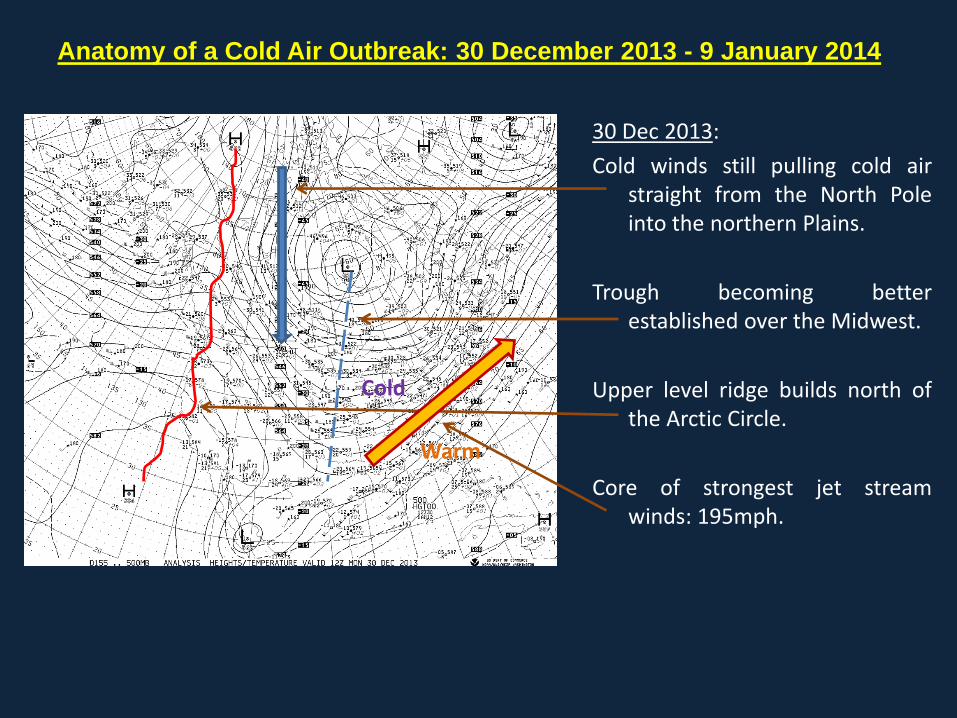
30 Dec 2013:
Cold winds still pulling cold air straight from the North Pole into the northern Plains.
Trough becoming better established over the Midwest.
Upper level ridge builds north of the Arctic Circle.
Core of strongest jet stream winds: 195mph.
Anatomy of a Cold Air Outbreak: 30 December 2013 - 9 January 2014
Warm
Cold

30 Dec 2013:
Front has pushed through the Great Lakes...with sub-zero temperatures into the upper Midwest.
Note warmer temperatures over Michigan thanks to the moderating effects of the surrounding lakes.
Anatomy of a Cold Air Outbreak: 30 December 2013 - 9 January 2014
0 0 -10 -10 -20 -20 -30 -30

2 Jan 2014:
Trough firmly in place across the Midwest...moving east which is leading to the development of low pressure over the Ohio valley (which we’ll see on the next slide).
Upper level ridge over the western U.S.
Anatomy of a Cold Air Outbreak: 30 December 2013 - 9 January 2014

2 Jan 2014:
Still quite cold across central Canada and the Upper Midwest and Upper Peninsula with sub-zero temperatures.
Developing low pressure bringing snow to the Ohio Valley and southern Michigan.
High Temperatures 2 January:
SSM 1
GLR 6 (Low -20)
APN 6 (Low -8)
PLN 7 (Low -24)
Anatomy of a Cold Air Outbreak: 30 December 2013 - 9 January 2014
0 0 -30 -30

4 Jan 2014:
After a couple of days of moderating temperatures... cold air is reloading again through the Rocky Mountain and High Plains.
Upper level ridge reforming over the eastern Pacific...pattern is repeating itself.
Anatomy of a Cold Air Outbreak: 30 December 2013 - 9 January 2014

4 Jan 2014:
Next cold front and push of Arctic air coming across the Midwest.
South winds ahead of the front helping warm things up temporarily across Michigan.
North winds bringing the cold back into the Plains states.
Anatomy of a Cold Air Outbreak: 30 December 2013 - 9 January 2014
0 0

6 Jan 2014:
Heart of the cold air firmly entrenched across the nation’s midsection.
Very strong upper level trough develops and the polar vortex gets displaced south into northwest Ontario and the upper Great Lakes.
Anatomy of a Cold Air Outbreak: 30 December 2013 - 9 January 2014

6 Jan 2014:
Brisk northwest winds bringing the cold to Michigan and Midwest down into the southeastern U.S.
High Temperatures 7 January:
SSM 4
GLR 4
HTL 5
PLN 8
APN 8
TVC 9
Anatomy of a Cold Air Outbreak: 30 December 2013 - 9 January 2014
0 0 -10 -10 -20 -20
-30 -30

10 Jan 2014:
Cold air breaks...southwest winds allows warmer air to flood back into Michigan.
High temperatures back into the 30s and 40s by 10 January.
Polar vortex returns to its normal position across the Arctic for now...it will make another return southward 10 days hence (bringing an even colder air mass to Michigan).
Anatomy of a Cold Air Outbreak: 30 December 2013 - 9 January 2014

Upper level flow forecast this coming Sunday evening!

Thank You For Your
Attention!
The End