Winter Bird Survey Report
28
HARRAS MOOR WHITEHAVEN WINTER BIRD SURVEY REPORT TEP Genesis Centre Birchwood Science Park Warrington WA3 7BH Tel: 01925 844004 Email: [email protected] www.tep.uk.com Offices in Warrington, Market Harborough, Gateshead, London and Cornwall PLANNING I DESIGN I ENVIRONMENT
Transcript of Winter Bird Survey Report

HARRAS MOOR
WHITEHAVEN
WINTER BIRD SURVEY REPORT
TEP
Genesis Centre
Birchwood Science Park
Warrington
WA3 7BH
Tel: 01925 844004
Email: [email protected]
www.tep.uk.com
Offices in Warrington, Market Harborough, Gateshead, London and Cornwall
PLANNING I DESIGN I ENVIRONMENT
Harras Moor Whitehaven Winter Bird Survey Report
Document Title Winter Bird Survey Report
Prepared for Homes England
Prepared by TEP - Warrington
Document Ref 5060.ECO.HarrasMoorEcoandArb.005.004
Author Damian Young
Date May 2018
Checked Mike Walker
Approved Francis Hesketh
Amendment History
Version Date Modified
by
Check /
Approved
by
Reason(s) issue Status
2.0 25/05/18 Lynsey
Crellin
Francis
Hesketh Report date. Para 3.4 typo. Final

Harras Moor Whitehaven Winter Bird Survey Report
5060.ECO.HarrasMoorEcoandArb.005 Page 3 May 2018 2.0
CONTENTS PAGE
1.0 Introduction ............................................................................................................. 4
2.0 Method .................................................................................................................... 5
3.0 Results .................................................................................................................... 6
4.0 Implications and Recommendations ........................................................................ 9
TABLES PAGE
Table 1: Peak counts of wader, wildfowl, other waterbird, raptors, protected and BoCC
species on the ground within 500m of the proposed development site boundary during the
transect survey. ..................................................................................................................... 7
APPENDICES
APPENDIX A: Designated site citations
APPENDIX B: Winter bird survey weather data
DRAWINGS
G05060.Eco.HarrasMoorEcoandArb.003
G05060.Eco.HarrasMoorEcoandArb.006
G05060.Eco.HarrasMoorEcoandArb.008
G05060.Eco.HarrasMoorEcoandArb.010
G05060.Eco.HarrasMoorEcoandArb.011

Harras Moor Whitehaven Winter Bird Survey Report
5060.ECO.HarrasMoorEcoandArb.005 Page 4 May 2018 2.0
1.0 Introduction
1.1 TEP was commissioned in September 2017 by Homes England to determine the
usage of the site off Caldbeck Road, Harras Moor, Whitehaven, by overwintering
birds.
1.2 Homes England is proposing construction of housing with associated infrastructure.
Site Description
The site primarily comprises poor semi-improved grassland fields used for grazing
animals although some areas are unmanaged and have become overgrown. There
are areas of marshy grassland within a number of the fields and many of the fields
are bordered by strips of mixed plantation woodland of varying ages. Scrub and
hedgerows are present in areas across the site. Existing residential and commercial
development bounds the site on 3 sides and there is a golf course at the northeast
border. The central grid reference of the site is NX986180 and the location of the site
is shown at Figure 1.
Site Suitability for Overwintering Birds
1.3 The grassland habitat within the northern part of site provides suitable refuge and
foraging opportunities for overwintering birds, including waders and raptors. The
woodland, hedgerows and scrub within the site has potential to support various
woodland and woodland edge passerine species of conservation concern.
Figure 1

Harras Moor Whitehaven Winter Bird Survey Report
5060.ECO.HarrasMoorEcoandArb.005 Page 5 May 2018 2.0
2.0 Method
Winter Bird Survey
2.1 The winter bird survey comprised five visits across the months of November 2017 to
March 2018. October to March forms the winter period where species of potential
interest for this site are likely to be present in the area.
2.2 During each survey visit a transect route was walked throughout the proposed
development site and surrounding area (up to 500m from site boundary). The transect
surveys lasted for between four and six hours.
2.3 Birds recorded during the transect survey included: all wader, wildfowl and raptor
species; Birds of Conservation Concern (BoCC) Amber or Red List species; priority
species listed under Section 41 of the Natural Environment and Rural Communities
(NERC) Act (2006); and protected species listed on Schedule 1 of the Wildlife and
Countryside Act (1981, as amended). Additionally, any species listed as qualifying
features of the Solway Firth proposed Special Protection Area (pSPA) were recorded.
This marine designation is ca 1.8km west of the proposed development, and it is
possible that some qualifying species may use farmland for roosting or foraging.
2.4 Observations were recorded directly onto the survey map.

Harras Moor Whitehaven Winter Bird Survey Report
5060.ECO.HarrasMoorEcoandArb.005 Page 6 May 2018 2.0
3.0 Results
Designated Sites
3.1 There are no internationally designated sites within 1km of the application site,
however the following statutory sites are located within the wider area:
St Bees Head SSSI 1.7km Southwest
River Ehen SAC and River Ehen SSSI 5.3km Southeast
3.2 Although the site falls within Natural England's Impact Risk Zone (IRZ) for the above
SSSI sites, the residential proposals are unlikely to impact upon the designated sites.
Neither of these statutory sites are designated for wintering birds.
3.3 The Solway Firth proposed Special Protection Area (pSPA) is not formally designated
but has the same planning status as if it were. It is (at its closest point) 1.8km west
of the site. It is a marine site which is a proposed southwards extension of an existing
SPA. The pSPA supports internationally important non-breeding numbers of five
specific waterfowl and waders, of which one (golden plover) might use inland sites
with the grassland and woodland habitats present at Harras Moor.
3.4 The pSPA also supports an assemblage of internationally important numbers of
migratory and non-breeding waterfowl, waders, wintering gulls and other waterbirds,
of which the following might use inland sites like Harras Moor:
Oystercatcher
Grey plover
Lapwing
Curlew
Black-headed gull
Common gull
Herring gull
3.5 There are five locally designated sites within 1km of the application site, which are:
Midgey Gill County Wildlife Site (CWS) lies 50m southwest of the site
boundary. This site however is 200m from the development boundary.
Castle Park Woodland CWS lies 130m west of the site.
Hope Mission Pond CWS lies 700m north east of the site.
Priestgill Wood Site of Invertebrate Significance lies 650m east of the site.
Snebra Hill Local Geological site lies 790m south of the site.
3.6 None of these locally designated sites have been designated for their bird interest.
Winter Bird Survey
3.7 The results of the 2017-2018 winter bird survey are illustrated in Drawings
G5060.Eco.HarrasMoorEcoandArb.003 to .011. Counts for each species during each
survey visit are presented in Table 1.
Harras Moor Whitehaven Winter Bird Survey Report
5060.ECO.HarrasMoorEcoandArb.005 Page 7 May 2018 2.0
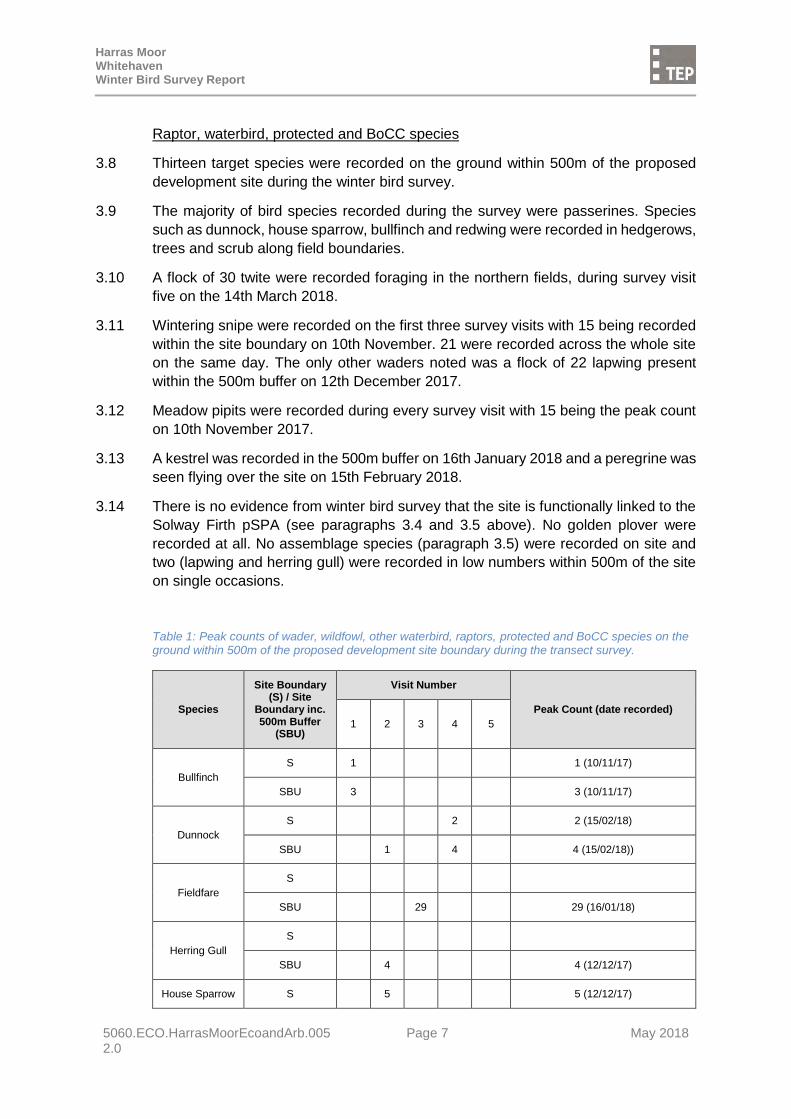
Raptor, waterbird, protected and BoCC species
3.8 Thirteen target species were recorded on the ground within 500m of the proposed
development site during the winter bird survey.
3.9 The majority of bird species recorded during the survey were passerines. Species
such as dunnock, house sparrow, bullfinch and redwing were recorded in hedgerows,
trees and scrub along field boundaries.
3.10 A flock of 30 twite were recorded foraging in the northern fields, during survey visit
five on the 14th March 2018.
3.11 Wintering snipe were recorded on the first three survey visits with 15 being recorded
within the site boundary on 10th November. 21 were recorded across the whole site
on the same day. The only other waders noted was a flock of 22 lapwing present
within the 500m buffer on 12th December 2017.
3.12 Meadow pipits were recorded during every survey visit with 15 being the peak count
on 10th November 2017.
3.13 A kestrel was recorded in the 500m buffer on 16th January 2018 and a peregrine was
seen flying over the site on 15th February 2018.
3.14 There is no evidence from winter bird survey that the site is functionally linked to the
Solway Firth pSPA (see paragraphs 3.4 and 3.5 above). No golden plover were
recorded at all. No assemblage species (paragraph 3.5) were recorded on site and
two (lapwing and herring gull) were recorded in low numbers within 500m of the site
on single occasions.
Table 1: Peak counts of wader, wildfowl, other waterbird, raptors, protected and BoCC species on the ground within 500m of the proposed development site boundary during the transect survey.
Species
Site Boundary (S) / Site
Boundary inc. 500m Buffer
(SBU)
Visit Number
Peak Count (date recorded)
1 2 3 4 5
Bullfinch
S 1 1 (10/11/17)
SBU 3 3 (10/11/17)
Dunnock
S 2 2 (15/02/18)
SBU 1 4 4 (15/02/18))
Fieldfare
S
SBU 29 29 (16/01/18)
Herring Gull
S
SBU 4 4 (12/12/17)
House Sparrow S 5 5 (12/12/17)

Harras Moor Whitehaven Winter Bird Survey Report
5060.ECO.HarrasMoorEcoandArb.005 Page 8 May 2018 2.0
Species
Site Boundary (S) / Site
Boundary inc. 500m Buffer
(SBU)
Visit Number
Peak Count (date recorded)
1 2 3 4 5
SBU 2 12 12 (12/12/17)
Kestrel
S
SBU 1 1 (16/01/18)
Lapwing
S
SBU 22 22 (12/12/17)
Meadow Pipit
S 15 3 1 1 2 15 (10/11/17)
SBU 20 8 1 1 2 20 (10/11/17)
Redwing
S 21 21 (15/02/18)
SBU 21 21 (15/02/18)
Snipe
S 15 2 15 (12/12/17)
SBU 17 21 2 21 (12/12/18)
Song Thrush
S 1 1 1 (16/01/18 and 15/02/18)
SBU 1 1 1 1 (12/12/17,16/01/18 and 15/02/18)
Starling
S 27 12 27 (16/01/18)
SBU 15 28 12 12 28 (16/01/18)
Twite
S 30 30 (14/03/18)
SBU 30 30 (14/03/18)
S: Site; SBU: Site including 500m buffer Visit 1: 10th October 2017; Visit 2: 12th December 2017; Visit 3: 16th January 2018; Visit 4: 15th February 2018; Visit 5: 14th March 2018

Harras Moor Whitehaven Winter Bird Survey Report
5060.ECO.HarrasMoorEcoandArb.005 Page 9 May 2018 2.0
4.0 Implications and Recommendations
4.1 Thirteen raptor, waterbird, protected or BoCC species were recorded on the ground
within 500m of the proposed site boundary during the winter bird survey. Generally
low numbers of each of these species was recorded.
4.2 The site is assessed to be of less than local importance for wintering birds, due to the
low numbers of priority bird species recorded to use the site during the survey.
4.3 There is no functional linkage between the site and the Solway Firth proposed Special
Protection Area.
4.4 Snipe appear to have been wintering at the site in the areas of damp grassland during
the first half of the winter. These however appear to have moved on towards the latter
part of the survey. Snipe are likely to be present on fields throughout the wider area.
It is recommended that the areas of marshy grassland are retained within the site
where possible, to continue to form suitable wintering habitat for this species.
4.5 Twite winter in coastal areas in the UK. Birds recorded along the western coast, such
as the birds recorded within the site on the fifth survey visit, are likely to be birds that
breed in Scotland. Twite are mobile through the winter and were likely to be passing
through the site, rather than the site forming important habitat for this species. With
the volume of suitable feeding habitat nearby, they are likely to be unaffected by the
proposals.
4.6 Many of the other passerines recorded are associated with the hedgerows and
woodland on site. These include Birds of Conservation Concern species such as
bulfinch, dunnock, house sparrow, redwing and song thrush. The hedgerow and
woodland habitats should be retained within the site wherever possible.

Harras Moor Whitehaven Winter Bird Survey Report
5060.ECO.HarrasMoorEcoandArb.005 Appendices May 2018 2.0
APPENDIX A: Designated site citations

Solway Firth
Proposed Special Protection Area (pSPA)
NO. UK9005012
SPA Site Selection Document:
Summary of the scientific case for site selection
A composite of the existing Upper Solway Flats and Marshes SPA
and a proposed marine extension

1
1. Introduction This document provides Scottish Natural Heritage’s (SNH) and Natural England’s (NE) advice on the proposed extension to the existing Upper Solway Flats and Marshes Special Protection Area (SPA) in the marine waters of the “Solway Firth” for inshore non-breeding waterfowl and non-breeding gulls. The proposal includes a name change from the Upper Solway Flats and Marshes SPA to the Solway Firth proposed SPA to include the marine extension. From this point forward, the site will be referred to as the Solway Firth proposed SPA (pSPA). The document summarises the evaluation for each of the species of interest according to the SPA site selection guidelines (JNCC, 1999) and provides an overview of how the site boundary was developed. The Solway Firth pSPA has been selected to provide protection to important wintering grounds used by feeding and roosting red-throated diver, common scoter and goosander which migrate to the UK or from inland breeding sites every year to overwinter or to stop off at as one of their staging posts while on migration. The Solway is also notable for its concentrations of three species of non-breeding gulls. The protection of these inshore waters will make a key contribution to the maintenance of these species in their natural range in UK marine waters and form part of a coherent network of sites at a European level. The importance of the marine environment for birds which spend all or part of their lives around our coasts is well recognised. A total of 106 species of bird are thought to use UK marine waters of which 45 occur in numbers greater than fifty each year and are dependent on the marine environment for a large part of their lifecycle. All of these 45 species except one (black guillemot1) are considered rare or vulnerable bird species (Annex 1), or regularly occurring migratory species by the Birds Directive (EC Directive on the conservation of wild birds (amended) - 2009/147/EC). This means that all Member States are obliged to take account of the requirements of Article 4.1 of the Birds Directive for each of these 44 species. Article 4.1 states that “Member States shall classify in particular the most suitable territories in number and size as special protection areas for the conservation of these species, taking into account their protection requirements in the geographical sea and land area where this Directive applies”. EU guidance on the establishment of SPAs in the marine environment (2007) sets out the groups of marine birds for which SPAs should be considered in the marine environment. This includes sites for non-breeding waterfowl and gulls. In the UK, whilst some coastal SPAs include marine waters below the Mean High Water Springs (MHWS) there are only four entirely marine SPAs classified; Outer Thames Estuary SPA (England), Liverpool Bay/Bae Lerpwl SPA (England/Wales) and Bae Caerfyrddin/Carmarthen Bay SPA (Wales) and Belfast Lough - Open Water SPA (Northern Ireland). In Scotland, 31 marine extensions to seabird colony SPAs
1 Nature Conservation Marine Protected Areas were designated in August 2014 for black guillemot.

2
have also been classified. The existing suite of sites is not considered sufficient to meet the requirements of Article 4.1 because it currently does not include suitable territories at sea for all of the species that the UK has a responsibility for. Additionally, the UK SPA Review (Stroud, 2001) which concentrated on terrestrial SPAs highlighted that the UK had no existing SPAs to support wintering gulls. The Review recommended that appropriate data be collected to allow a national (UK) assessment of wintering gulls to enable the consideration of additional SPAs. Furthermore, the Review also concluded that there were not enough SPAs for species such as lapwing, ringed plover and great cormorant and that these species should be added into existing sites and new sites, where their populations met the required selection guidelines. The Solway Firth is being proposed as part of a suite of marine sites that aim to fulfil the requirements for SPAs in the marine environment for rare or vulnerable birds and regularly occurring migratory birds in the UK. As required by Article 4 of the Directive, the classification of the extended area of this site will enable the application of special conservation measures concerning the habitat of Annex 1 and regularly occurring migratory birds in order to ensure their survival and reproduction in their area of distribution. Full details of the site survey methodologies, data and analysis used to inform the proposed selection of this site are provided in Lawson et al (2015) for non-breeding inshore waterfowl and Burton et al (2013) for non-breeding gulls. All scientific work received full external independent peer review at key stages.
2. Site summary The Solway Firth pSPA is a large estuarine/marine site with a total area of 1357.49km2 situated between the western coastal margins of Cumbria in England and Dumfries and Galloway in Scotland, off the west coast of Great Britain (Figure 1). It is one of the largest estuaries in the UK along with Morecambe Bay and the Wash. The Solway Firth (including the classified Upper Solway Flats and Marshes SPA and the proposed marine extension) supports populations of European importance of the following Annex 1 species:
Red-throated diver (Gavia stellata)2 Whooper swan (Cygnus cygnus) Barnacle goose (Branta leucopsis) Golden plover (Pluvialis apricaria) Bar-tailed godwit (Limosa lapponica)
2 Qualifying Annex 1 species of the pSPA marine extension

3
And supports migratory populations of European importance, of the following species:
Pink footed goose (Anser brachyrhynchus) Shelduck (Tadorna tadorna)* Teal (Anas crecca)* Pintail (Anas acuta) Shoveler (Anas clypeata)* Scaup (Aythya marila) Common scoter (Melanitta nigra)*3 Goldeneye (Bucephala clangula)* Goosander (Mergus merganser)*3 Oystercatcher (Haematopus ostralegus) Knot (Calidris canutus) Ringed plover (Charadrius hiaticula)4 Grey plover (Pluvialis squatarola)* Lapwing (Vanellus vanellus)*4 Dunlin (Calidris alpina)* Sanderling (Calidris alba)* Redshank (Tringa totanus) Turnstone (Arenaria interpres)* Curlew (Numenius arquata) Cormorant (Phalacrocorax carbo)*4 Black –headed gull (Larus ridibundus)*4 Common gull (Larus canus)*4 Herring gull (Larus argentatus)*4
*Named qualifiers of the water bird assemblage. The coastal area within the existing SPA includes a range of habitats including mudflats and sandflats, lagoons, salt marshes and inland water bodies. This diversity is extended into the marine environment with the sea bed comprising a wide range of mobile sediments. The inner Solway firth is shallow often less than 10m deep, as is Wigtown Bay. This and the funnel-like shape of the inner firth cause strong tidal currents and therefore the sediments tend to be predominantly sandy nature. Channels within the estuary are constantly moving changing the shapes of sandbanks. The tidal currents decrease in speed to the north of the Irish Sea, and hence the sea-bed sediments generally become muddier. However, northwards towards the entrance to Luce Bay, the sea bed is largely covered with a coarse gravel overlying till or glacial sediments. The extensive mudflats and sandflats of the Solway support a typical estuarine fauna including a mix of polychaetes worms and bivalves, together with vast numbers of
3 Qualifying migratory species of the pSPA marine extension 4 Species included as part of the 2001 UK SPA Review requirements

4
the burrowing amphipods Corophium volutator and Bathyporeia species (Perkins 1973). A wide range of pelagic and demersal fish also occur in the area, which acts as spawning grounds or nursery areas for a number of species. Red-throated divers and goosanders move to coastal areas in winter from their breeding sites and feed on a wide variety of fish, which they catch by diving from the surface and pursuing their prey underwater. The fish species taken will be influenced by what is locally most readily available, but the diet of divers and goosanders can include haddock Melanogrammus aeglefinus, cod Gadus morhua, herring Clupea harengus, sprats Sprattus sprattus and gurnard Eutrigla gurnardus along with smaller species such as sand-eels Ammodytidae, pipefish Syngathidae, gobies Gobiidae, flatfish Pleuronectidae and butterfish Pholis gunnellus. Common scoter feed almost exclusively on molluscs and small crustaceans, diving from the surface to pluck their prey from the sea bed. Diving activity varies among species but average foraging dive depths for red-throated diver, common scoter and goosander are shallower than 15m. The presence of high densities of non-breeding waterfowl at this site is indicative of the productivity and availability of prey these shallow waters and their habitats provide. Black-headed gull, common gull and herring gull use the inshore waters primarily for roosting, although some day time foraging in intertidal areas will also take place. Whilst the shallower areas may be the focus for foraging activities, the wider area within close proximity will also be used by non-breeding birds for preening, moulting, loafing and roosting. The northern Irish Sea is relatively land-locked and the exposure of coasts to winds is variable. Local topography and wind direction are important in determining local conditions and extreme wind speeds and therefore prime factors in determining suitable habitat for birds that over-winter.

5
Figure 1. The Solway Firth pSPA.
Harras Moor Whitehaven Winter Bird Survey Report 2017 - 2018
5060.ECO.HarrasMoorEcoandArb.005 Appendices April 2018 1.0
Name: St Bees Head
District: Copeland
Status: Site of Special Scientific Interest (SSSI) notified under Section 28 of the Wildlife and
Countryside Act 1981.
Local Planning Authority: Copeland District Council
National Grid Reference: NX 945133 Area: 171.52 (ha) 423.7 (ac)
Ordnance Survey Sheet 1:50,000: 89 1:10,000: NX 91 SE, NX 91 NE,
NX 91 SW, NX 91 NW
Date Notified (Under 1949 Act): 1959 Date of Last Revision: 1968, 1984, 1995
Date Notified (Under 1981 Act): 1995
Other Information:
1. The boundary of this site has been modified by an extension at this revision, to
incorporate new geological sites.
2. This site incorporates five Geological Conservation Review sites, locations in Saltom Bay
and Fleswick-St Bees Head, St Bees.
3. A large part of the site is managed as a nature reserve by the Royal Society for the
Protection of Birds.
Description and Reasons for Notification:
St Bees Head is the most westerly point on the Cumbria coast, approximately 1 km
southwest of Whitehaven. The SSSI comprises a 8 km stretch of coast between St Bees and
Whitehaven and encompasses the sheer cliff face, an area of cliff-top grassland and the
shore down to the mean low-water mark. The cliffs reach a height of 90 m in places and
expose the St Bees Sandstone, some sections of which are of great geological interest for
their sedimentary structures. Further south, the cliffs at St Bees are of considerable
importance for interpreting late Devensian glacial events and environmental conditions.
Further north, in Saltom Bay the foreshore and adjacent areas provide the best exposure of
the Permian rock sequence and marine strata in Cumbria and also the best available
exposure of the Whitehaven Sandstone formation.
The biological interest of the site is represented in a number of different habitats: natural cliff-
top grassland and heath, sheer cliff face and cliff-fall rubble, shingle and wave-cut platform.
The outstanding interest of this area lies, however, in the sheer cliffs which provide the only
breeding site on the coast of Cumbria for a variety of colonial seabirds. These include over
2,000 pairs of guillemots along with lesser numbers of fulmar, kittiwake, razorbill, cormorant,
puffin, shag and herring gull. The cliffs are, in addition, the only breeding site on the entire
coast of England for black guillemots. Several other birds are known to use this site regularly
for breeding and these include the tawny owl, sparrowhawk, peregrine, raven and rock pipit,
which is known to breed in only one other site in Cumbria. The rugged cliff face supports a

Harras Moor Whitehaven Winter Bird Survey Report 2017 - 2018
5060.ECO.HarrasMoorEcoandArb.005 Appendices April 2018 1.0
diverse flora in the crevices and ledges of the crumbling sandstone. Towards the cliff base,
sea pink or thrift Armeria maritima, scurvygrass Cochlaria officinalis and sea campion Silene
maritima are commonly found. Sea spleenwort Asplenium marinum occurs in damp crevices
and rock samphire Crithmum maritimum and the rare rock sea lavender Limonium
binervosum have also been recorded. Towards the top of the cliff, bloody cranesbill
Geranium sanguineum, wood vetch Viccia sylvatica and orpine Sedum telephium are found
and soft shield-fern Polystichum setiferum occurs in several rocky recesses. Along the cliff
top, on the dry sandy soils grassland with species such as dyerÕs greenweed Genista
tinctoria alternates with patches of western gorse Ulex gallii, heather Calluna vulgaris and
bracken Pteridium aquilinum.
The geological interest of the site is concentrated in three main areas, between Fleswick and
Rottington Beck and the cliffs of St Bees golf course in the south and around Saltom Bay at
the North End of the site. The middle part of the Lower Triassic St Bees Sandstone is
magnificently exposed at Fleswick Bay. The succession is dominated by fine to medium
grained sandstones bounded by major erosion surfaces. Sedimentary structures include
planar-tabular and trough cross-bedding, with minor cross-laminated siltstone and mudrock
intervals. The erosion surfaces separate a series of fining-upwards rock units, which are
similar to those of modern, sandy, braided-river deposits. Further south the upper St Bees
Sandstone is seen. Sedimentary structures such as infraformational conglomerates and
major erosion surfaces are well-developed and crossbedding here indicates fluvial transport
towards the north-north-west. An important feature is the presence of soft sediment
deformation structures which were produced by water escaping from the sediment after
deposition. This is a key site for the demonstration of fluvial environments in rocks and
Triassic age. The cliffs of the St Bees golf course and further south are a site of considerable
importance for interpreting Late-Devensian glacial events and Late-glacial environmental
conditions in northwest England. Coastal sections in a belt of hummocky deposits have over
the years revealed a succession of interbedded tills, sands and gravels. Although
interpretations differ in detail, parts of the succession have been referred to a re-advance of
Scottish ice on to the Cumbrian coast. The upper part of the succession is also significant in
providing lithostratigraphic and biostratigraphic evidence for Late-glacial environmental
conditions. Radiocarbon dates, pollen and coleoptera from a sequence of organic deposits
together provide complementary evidence for the sequence and timing of environmental
change during the Windermere Interstadial and Lock Lomond Stadial. St. Bees is therefore a
key site both for assessing the evidence for a readvance of Scottish ice and for
palaeoenvironmental studies. Some of the foreshore in Saltom Bay and adjacent areas (e.g.
disused quarries) provide the best exposure of the Permian rock sequence in West Cumbria.
A basal breccia (brockram) rests unconformably on the Whitehaven Sandstone
(Carboniferous) and passes upwards into the Saltom Dolomite, an Upper Permian marine
carbonate. The overlying St Bees Shales (Upper Permanian) are seen at Barrowmouth, and
southwards and ascending sequence in the lower part of the St Bees Sandstone shows a
variety of sedimentary features typical of a fluvial environment. This is a key locality affording
sections showing a variety of Lower and Upper Permian environments and facies.
The northernmost section of foreshore, towards Whitehaven is the best available exposure
of the Whitehaven Sandstone Formation, a sequence of red sandstones of middle
Westphalian (probably Westphalian C) age. They were originally thought to lie
unconformably on the underlying grey Coal Measures, but they are now believed to be
conformable. Their reddening is thus probably linked with that of the Etruria Formation in the

Harras Moor Whitehaven Winter Bird Survey Report 2017 - 2018
5060.ECO.HarrasMoorEcoandArb.005 Appendices April 2018 1.0
Midlands coalfields. The sedimentology of these strata have not been studied in detail, which
will be essential if the exact relationship of the sandstones to the other British sequences is
to be determined; and Saltom Bay provides the best available section for such a study. This
is a site of considerable scientific significance. The coastal section at Barrowmouth is the
best exposure of late Permian marine strata in Cumbria. The marine strata are represented
by 4.6 m of varied shallow-water dolomite (Saltom Dolomite Formation) that was formed
near the eastern edge of the Bakevellia Sea. Barrowmouth Beach is the only GCR site to
display marine Permian strata from the eastern margin of the Bakevellia Sea. Common
fossils in the sequence include the bivalves Bakevelli and Permophorus.

Harras Moor Whitehaven Winter Bird Survey Report
5060.ECO.HarrasMoorEcoandArb.005 Appendices May 2018 2.0
APPENDIX B: Winter bird survey weather data

Harras Moor Whitehaven Winter Bird Survey Report 2017 - 2018
5060.ECO.HarrasMoorEcoandArb.005 Appendices April 2018 1.0
Winter bird survey weather data
Visit/Date Surveyor Weather
Visit 1 10/11/2017 Lausanne Jenkins Overcast, breezy with light rain. Excellent visibility.
Visit 2 12/12/2017 Lausanne Jenkins Overcast, breezy and dry. Excellent visibility.
Visit 3 16/01/2018 Tim Ross Overcast, breezy and dry. Excellent visibility.
Visit 4 15/02/2018 Phil Askew Bright, sunny, dry and breezy. Excellent visibility.
Visit 5 14/03/2018 Phil Askew Dry, cloudy and still. Excellent visibility.

Harras Moor Whitehaven Winter Bird Survey Report
5060.ECO.HarrasMoorEcoandArb.005 Drawings May 2018 2.0
DRAWINGS
G05060.Eco.HarrasMoorEcoandArb.003 G05060.Eco.HarrasMoorEcoandArb.006 G05060.Eco.HarrasMoorEcoandArb.008 G05060.Eco.HarrasMoorEcoandArb.010 G05060.Eco.HarrasMoorEcoandArb.011

,
,
,
,
,
,,
,
,
,
,
,
,
,
, ,
,
,
,
,
,
,,
,
,
,
,
,
,
,
þþ
/F
þ
þ
co l
co l
þþ
_̂
_̂
_̂
_̂
_̂
_̂ _̂
_̂
_̂
_̂
_̂
_̂
_̂
_̂
_̂
_̂
_̂
_̂
_̂_̂
_̂
_̂
_̂
_̂
A595LoopRoadSou th Harras Road
Highfields
SH
7MP
BH
K
BF
MP
MP
7MP
2BF
SN
K
2MP
7SN
3MPSN
8SN
3HG
ST
HG
HG
HG
3SG 2HG
2HG
2SG
6HG
HG
30SG
3HG
SG
3HG
HG
HS
HS
10SG
HG
HG
2SG
298000
298000
299000
299000
5170
00
5170
00
5180
00
5180
00
5190
00
5190
00
Project
Drawing Number
Drawn
Title
Checked Approved
JSRH KS 16/01/20181:8,000 @ A3
Genesis Centre, Birchwood Science Park, Warrington WA3 7BHTel 01925 844004 e-mail [email protected] www.tep.uk.com
Scale Date
Rev Description Drawn Approved Date
Site Map
1:60,000
0 300 600150
Metres
KEYSite Boundary
500m Offset from Site Boundary
_̂ Section 41 Species
co l Colony
þþ Alarm Call
þ Calling
/F Male
,
Directional Flightline
Winter Bird Survey - Visit 1 10th
November 2017
Harras Moor, Cumbria
G5060.Eco.HarrasMoorEcoandArb.003
NoteRed Red List Species
Amber Amber List Species
Reproduced by permission of Ordnance Survey on behalf of Her Majesty's
Stationery Office.
Contains OS data © Crown Copyright and database right 2017. All rights reserved.
Base mapping provided by client
Bird Species List BF Bullfinch BH Black-headed Gull HG Herring Gull HS House Sparrow K Kestrel
MP Meadow Pipit SG Starling SH Sparrowhawk SN Snipe ST Song Thrush

,
,
, ,
,
,
,
,
,
,
,
,
,
, ,
,
,
,,
,
,
,
,
,
,,
þ co l
þ
þþ
_̂
_̂
_̂
_̂
_̂_̂
_̂
_̂
_̂
_̂
_̂
_̂
_̂
_̂
_̂
_̂_̂ _̂
_̂
_̂_̂
_̂
A595LoopRoadSo ut h Harras Road
High
fields
2BZ
2SN4SN
4BHMP SN
2MP3SN
SN
6SN5MPD
2BHMP
MP
2SN
2SN
22L
SG
2HG
2HG
HGHG
HGHG
HS
4SG
HG
4SGHG
SG
22SG4HS ST HG
HG 7HS
HG
298000
298000
299000
299000
5170
00
5170
00
5180
00
5180
00
5190
00
5190
00
Project
Drawing Number
Drawn
Title
Checked Approved
JS/LJAP KS 09/04/20181:8,000 @ A3
Genesis Centre, Birchwood Science Park, Warrington WA3 7BHTel 01925 844004 e-mail [email protected] www.tep.uk.com
Scale Date
Rev Description Drawn Approved Date
Site Map
1:60,000
0 300 600150
Metres
KEYSite Boundary
500m Offset from Site Boundary
_̂ Section 41 Species
þ co l Colony Calling
þ Calling
,
Directional Flightline
Winter Bird Survey - Visit 2 12th
December 2017
Harras Moor, Cumbria
G5060.Eco.HarrasMoorEcoandArb.006
NoteRed Red List Species
Amber Amber List Species
Reproduced by permission of Ordnance Survey on behalf of Her Majesty's
Stationery Office.
Contains OS data © Crown Copyright and database right 2017. All rights reserved.
Base mapping provided by client
Bird Species List BH Black-headed Gull BZ Buzzard D Dunnock HG Herring Gull HS House Sparrow
L Lapwing MP Meadow Pipit SG Starling SN Snipe ST Song Thrush

,
,
,
/F
_̂
_̂
_̂
_̂
_̂
_̂
A595LoopRoadSo ut h Harras Road
High
fields
K
SN
MP
SN ST
12SG
HG
HG
29FF
3SG
298000
298000
299000
299000
5170
00
5170
00
5180
00
5180
00
5190
00
5190
00
Project
Drawing Number
Drawn
Title
Checked Approved
MKRH TR 09/04/20181:8,000 @ A3
Genesis Centre, Birchwood Science Park, Warrington WA3 7BHTel 01925 844004 e-mail [email protected] www.tep.uk.com
Scale Date
Rev Description Drawn Approved Date
Site Map
1:60,000
0 300 600150
Metres
KEYSite Boundary
500m Offset from Site Boundary
_̂ Section 41 Species
_̂ Schedule 1 Species
/F Male
,
Directional Flightline
Winter Bird Survey - Visit 3 16th
January 2018
Harras Moor, Cumbria
G5060.Eco.HarrasMoorEcoandArb.008
NoteRed Red List Species
Amber Amber List Species
Reproduced by permission of Ordnance Survey on behalf of Her Majesty's
Stationery Office.
Contains OS data © Crown Copyright and database right 2017. All rights reserved.
Base mapping provided by client
Bird Species List FF Fieldfare HG Herring Gull K Kestrel MP Meadow Pipit SG Starling
SN Snipe ST Song Thrush

,
,
,
,
,
,
,
_̂
_̂
_̂
_̂
_̂
_̂
_̂
_̂
A595LoopRoadSou th Harras Road
Highfields
BZ
PE
K
MP
MP
D
D
HG
3HGHG
HG
21RE
298000
298000
299000
299000
5170
00
5170
00
5180
00
5180
00
5190
00
5190
00
Project
Drawing Number
Drawn
Title
Checked Approved
JSJO TR 22/03/20181:8,000 @ A3
Genesis Centre, Birchwood Science Park, Warrington WA3 7BHTel 01925 844004 e-mail [email protected] www.tep.uk.com
Scale Date
Rev Description Drawn Approved Date
Site Map
1:60,000
0 300 600150
Metres
KEYSite Boundary
500m Offset from Site Boundary
_̂ Section 41 Species
_̂ Schedule 1 Species
,
Directional Flightline
Winter Bird Survey - Visit 4 15th
February 2018
Harras Moor, Cumbria
G5060.Eco.HarrasMoorEcoandArb.010
NoteRed Red List Species
Amber Amber List Species
Reproduced by permission of Ordnance Survey on behalf of Her Majesty's
Stationery Office.
Contains OS data © Crown Copyright and database right 2017. All rights reserved.
Base mapping provided by client
Bird Species List BZ Buzzard D Dunnock HG Herring Gull K Kestrel MP Meadow Pipit
PE Peregrine RE Redwing

,,
,
_̂
_̂
_̂_̂
A595LoopRoadSo ut h Harras Road
High
fields
BZ
2MP30TW
12SG
4HG HG
298000
298000
299000
299000
5170
00
5170
00
5180
00
5180
00
5190
00
5190
00
Project
Drawing Number
Drawn
Title
Checked Approved
JSRH TR 03/04/20181:8,000 @ A3
Genesis Centre, Birchwood Science Park, Warrington WA3 7BHTel 01925 844004 e-mail [email protected] www.tep.uk.com
Scale Date
Rev Description Drawn Approved Date
Site Map
1:60,000
0 300 600150
Metres
KEYSite Boundary
500m Offset from Site Boundary
_̂ Section 41 Species
,
Directional Flightline
Winter Bird Survey - Visit 5 14th
March 2018
Harras Moor, Cumbria
G5060.Eco.HarrasMoorEcoandArb.011
NoteRed Red List Species
Amber Amber List Species
Reproduced by permission of Ordnance Survey on behalf of Her Majesty's
Stationery Office.
Contains OS data © Crown Copyright and database right 2017. All rights reserved.
Base mapping provided by client
Bird Species List BZ Buzzard HG Herring Gull MP Meadow Pipit SG Starling TW Twite

HEAD OFFICE MARKET HARBOROUGH
GATESHEAD LONDON CORNWALL
Genesis Centre, Birchwood Science Park, Warrington WA3 7BH
No. 1 The Chambers, Bowden Business Village, Market Harborough, Leicestershire, LE16 7SA
Office 26, Gateshead International Business Centre, Mulgrave Terrace, Gateshead NE8 1AN
8 Trinity Street, London, SE1 1DB
4 Park Noweth, Churchtown, Cury, Helston Cornwall TR12 7BW
Tel: 01925 844004 Tel: 01858 383120 Tel: 0191 605 3340 Tel: 020 3096 6050 Tel: 01326 240081 E-mail: [email protected] E-mail: [email protected] E-mail: [email protected] E-mail: [email protected] E-mail: [email protected]