Wind Resource Measurement and Analysis for Wind Energy...
1
Download the poster Confex2017.com #confex2017 1. Ishihara T, Yamaguchi A, Goit JP and Tanemoto J 2017 Annual Meeting JAWE pp.87-88 2. Ishihara T and Qian G 2016 24 th Wind Eng. Symposium pp. 151-156 Wind Resource Measurement and Analysis for Wind Energy Application using Scanning Doppler Lidar Jay Prakash Goit, Atsushi Yamaguchi and Takeshi Ishihara Department of Civil Engineering, The University of Tokyo Abstract Test Site and Measurement Setup Objectives Summary Measurement Techniques and their Validation References PO.097 The scanning Doppler Lidar-based wind field measurements and analysis techniques are evaluated for wind energy application. The Lidar measurements are first validated against measurements from existing V1 Lidar, showing good agreement even for the availability limit of 20%. Vertical profiles of wind blowing from land and that from sea, measured using DBS configuration shows that later is significantly higher. A method is proposed to retrieve velocity vector field from the measured radial wind speed using RHI and PPI scans and is employed to investigate near shore velocity fields and wind turbine wake. An internal boundary layer develops from the shore and persists up to 2000m offshore. Flow field around wind turbine shows the characteristic velocity deficit in wind turbine wakes. Lidar measurements data are also used to validate mesoscale simulation and a wake model. Results 285 m Lidar 3.5 Km N Choshi http://www.leosphere.com/ Windcube 100S Met tower MWT92/2.4 Measurement data collected from Choshi offshore wind energy test facility Meteorological tower equipped with two Lidars on the platform, other sensors at multiple heights Doppler beam swinging (DBS) configuration x (E) y (N) Lidar u= − 2 cos , v= − 2 cos , w= Retrieval of velocity vector = mes max × 100% 10 = No. of 10 min avg data for ≥ lim Maximum possible 10 min avg data Availability lim =20% lim =80% Comparison of 100S and V1 Agreement is better when lim =80% …but availability drops significantly at higher altitude Even for lim =20%, agreement is fairly good Evaluate the performance of Lidar technology in measurement of wind field and propose methods for processing of measured data Characterize near shore marine atmospheric boundary layer (ABL) Measure and characterize wind turbine wake Use Lidar measurement to validate mesoscale and wake models. Plan-position indicator (PPI) Range height indicator (RHI) =∙ = cos sin + cos cos = sin , = cos Retrieval of velocity vector Wind direction ( ) from wind vane on nacelle or met tower is used Vertical profiles of wind from land & from sea Wind blowing from sea is significantly higher (35% high at hub height) Good agreement between measurement & mesoscale simulations up to 300 m. Lidar Close to coast 0 100 200 300 400 500 0 2 4 6 8 10 12 z [m] V [m/s] 0 100 200 300 400 500 0 2 4 6 8 10 12 z [m] V [m/s] Measurement 2km 667m 222m From Land From Sea Terrain effect 0 100 200 300 400 500 0 2 4 6 8 10 12 z [m] V [m/s] 0 100 200 300 400 500 0 2 4 6 8 10 12 z [m] V [m/s] Measurement 2km 667m 222m 1950 m from coast 2950 m from coast Simulations agree well with measurement RHI scan towards the northern coast Internal boundary layer develops and persists until 2000 m Measurement of wind turbine wake x/D=3 x/D=0.5 x/D=-1.0 Upstream x/D=6 Horizontal profiles of mean wind speed at hub height Lidar 80m Single PPI elevation scan Maximum velocity deficit at x/D = 3 Characteristic double peak observed in the measurements Wake model agrees with the measurements Validated Lidar measurement and proposed a method for retrieval of velocity vector from RHI PPI scans ABL profiles showed that wind from land is slower than that from sea IBL could be observed for wind blowing from the shore Measured and characterized wind turbine wake Acknowledgements: The study was carried out as a part of Offshore wind condition observation research program, funded by The New Energy and Industrial Technology Department Organization (NEDO).
Transcript of Wind Resource Measurement and Analysis for Wind Energy...
Download the poster
Confex2017.com #confex2017
1. Ishihara T, Yamaguchi A, Goit JP and Tanemoto J 2017 Annual Meeting JAWE pp.87-88
2. Ishihara T and Qian G 2016 24th Wind Eng. Symposium pp. 151-156
Wind Resource Measurement and Analysis for Wind Energy Application using Scanning Doppler Lidar
Jay Prakash Goit, Atsushi Yamaguchi and Takeshi Ishihara Department of Civil Engineering, The University of Tokyo
Abstract Test Site and Measurement Setup
Objectives
Summary
Measurement Techniques and their Validation
References
PO.097
The scanning Doppler Lidar-based wind field measurements and analysis techniques are evaluated for wind energy application. The Lidar measurements are first validated against measurements from existing V1 Lidar, showing good agreement even for the availability limit of 20%. Vertical profiles of wind blowing from land and that from sea, measured using DBS configuration shows that later is significantly higher. A method is proposed to retrieve velocity vector field from the measured radial wind speed using RHI and PPI scans and is employed to investigate near shore velocity fields and wind turbine wake. An internal boundary layer develops from the shore and persists up to 2000m offshore. Flow field around wind turbine shows the characteristic velocity deficit in wind turbine wakes. Lidar measurements data are also used to validate mesoscale simulation and a wake model.
Results
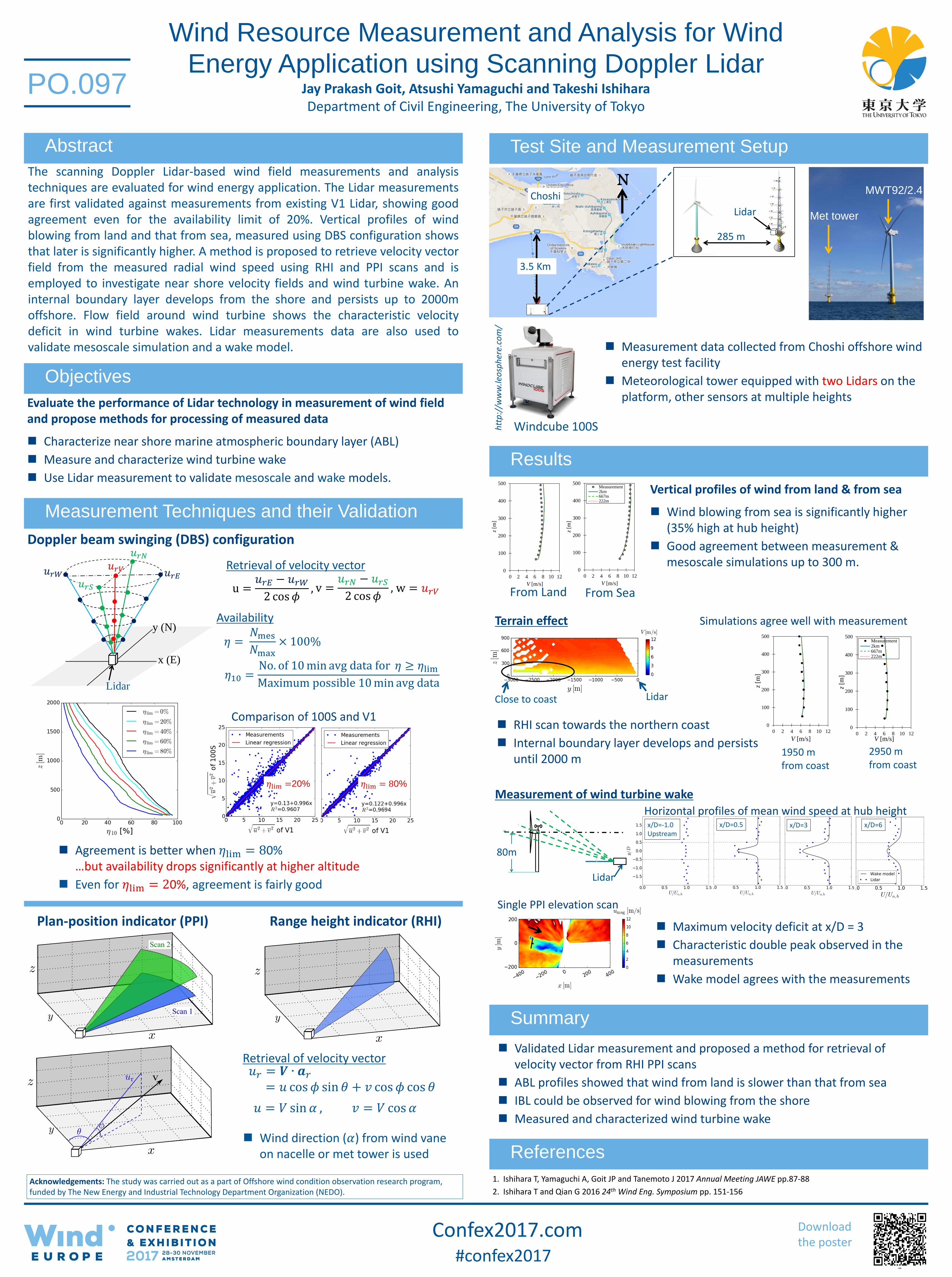
285 m
Lidar
3.5 Km
N Choshi
htt
p:/
/ww
w.le
osp
her
e.co
m/
Windcube 100S
Met tower
MWT92/2.4
Measurement data collected from Choshi offshore wind energy test facility
Meteorological tower equipped with two Lidars on the platform, other sensors at multiple heights
Doppler beam swinging (DBS) configuration
𝑢𝑟𝐸 𝑢𝑟𝑊
𝑢𝑟𝑁
𝑢𝑟𝑉
x (E)
y (N)
𝑢𝑟𝑆
Lidar
u =𝑢𝑟𝐸 − 𝑢𝑟𝑊
2 cos 𝜙, v =
𝑢𝑟𝑁 − 𝑢𝑟𝑆
2 cos 𝜙, w = 𝑢𝑟𝑉
Retrieval of velocity vector
𝜂 = 𝑁mes
𝑁max× 100%
𝜂10 =No. of 10 min avg data for 𝜂 ≥ 𝜂lim
Maximum possible 10 min avg data
Availability
𝜂lim =20% 𝜂lim = 80%
Comparison of 100S and V1
Agreement is better when 𝜂lim = 80% …but availability drops significantly at higher altitude
Even for 𝜂lim = 20%, agreement is fairly good
Evaluate the performance of Lidar technology in measurement of wind field and propose methods for processing of measured data
Characterize near shore marine atmospheric boundary layer (ABL)
Measure and characterize wind turbine wake
Use Lidar measurement to validate mesoscale and wake models.
Plan-position indicator (PPI) Range height indicator (RHI)
𝑢𝑟 = 𝑽 ∙ 𝒂𝑟
= 𝑢 cos 𝜙 sin 𝜃 + 𝑣 cos 𝜙 cos 𝜃
𝑢 = 𝑉 sin 𝛼 , 𝑣 = 𝑉 cos 𝛼
Retrieval of velocity vector
Wind direction (𝛼) from wind vane on nacelle or met tower is used
Vertical profiles of wind from land & from sea
Wind blowing from sea is significantly higher (35% high at hub height)
Good agreement between measurement & mesoscale simulations up to 300 m.
Lidar Close to coast
0
100
200
300
400
500
0 2 4 6 8 10 12
z [m
]
V [m/s]
0
100
200
300
400
500
0 2 4 6 8 10 12
z [m
]
V [m/s]
Measurement2km667m222m
From Land From Sea
Terrain effect
0
100
200
300
400
500
0 2 4 6 8 10 12
z [m
]
V [m/s]
0
100
200
300
400
500
0 2 4 6 8 10 12
z [m
]
V [m/s]
Measurement2km667m222m
1950 m from coast
2950 m from coast
Simulations agree well with measurement
RHI scan towards the northern coast
Internal boundary layer develops and persists until 2000 m
Measurement of wind turbine wake
x/D=3 x/D=0.5 x/D=-1.0 Upstream
x/D=6
Horizontal profiles of mean wind speed at hub height
Lidar
80m
Single PPI elevation scan
Maximum velocity deficit at x/D = 3
Characteristic double peak observed in the measurements
Wake model agrees with the measurements
Validated Lidar measurement and proposed a method for retrieval of velocity vector from RHI PPI scans
ABL profiles showed that wind from land is slower than that from sea
IBL could be observed for wind blowing from the shore
Measured and characterized wind turbine wake
Acknowledgements: The study was carried out as a part of Offshore wind condition observation research program, funded by The New Energy and Industrial Technology Department Organization (NEDO).