Winchester - Shenandoah at War · AREA. AT WAR. Winchester. Battlefield . Driving Tour. 1862...
4
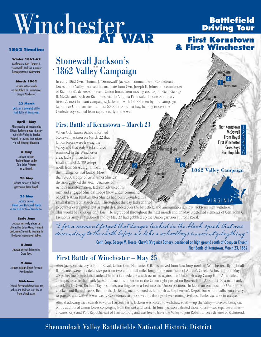
AREA AT WAR Winchester Battlefield Driving Tour 1862 Timeline Winter 1861-62 Confederate Gen. Thomas J. “Stonewall” Jackson in winter headquarters in Winchester. March 1862 Jackson retires south, up the Valley, as Union forces occupy Winchester. 23 March Jackson is defeated at the First Battle of Kernstown. April – May After pausing at modern-day Elkton, Jackson moves his army out of the Valley to deceive Federal forces and then returns via rail through Staunton. 8 May Jackson defeats Federal forces under Gen. John Frémont at McDowell. 23 May Jackson defeats a Federal garrison at Front Royal. 25 May Jackson defeats Union Gen. Nathaniel Banks at the First Battle of Winchester. Early June Jackson narrowly eludes an attempt by Union Gens. Frémont and James Shields to trap him in the lower Shenandoah Valley. 8 June Jackson defeats Frémont at Cross Keys. 9 June Jackson defeats Union forces at Port Republic. Mid-June Federal forces withdraw from the Valley and Jackson joins Lee in front of Richmond. Shenandoah Valley Battlefields National Historic District Stonewall Jackson’s 1862 Valley Campaign In early 1862 Gen. Thomas J. “Stonewall” Jackson, commander of Confederate forces in the Valley, received his mandate from Gen. Joseph E. Johnston, commander of Richmond’s defenses: prevent Union forces from moving east to join Gen. George B. McClellan’s push on Richmond via the Virginia Peninsula. In one of military history’s most brilliant campaigns, Jackson—with 18,000 men by mid-campaign— kept three Union armies—almost 60,000 troops—at bay, helping to save the Confederacy’s capital from capture early in the war. First Battle of Kernstown – March 23 When Col. Turner Ashby informed Stonewall Jackson on March 22 that Union forces were leaving the Valley and that only a token force remained in the Winchester area, Jackson marched his small army of 3,700 troops north from Strasburg. In fact, the intelligence was faulty. More than 8,000 troops of Gen. James Shields’ division guarded the area. Unaware of Ashby’s misinformation, Jackson advanced his men and engaged Shields’ troops (now under command of Col. Nathan Kimball after Shields had been wounded in a small skirmish on March 22). Throughout the day Jackson tried to counter every move, but as night descended over the battlefield and ammunition ran low, Jackson’s men withdrew. This would be Jackson’s only loss. He regrouped throughout the next month and on May 8 defeated elements of Gen. John C. Frémont’s army at McDowell and by May 23 had gobbled up the Union garrison at Front Royal. First Battle of Winchester – May 25 After Jackson’s victory at Front Royal, Union Gen. Nathaniel P. Banks moved from Strasburg north to Winchester. By nightfall Bank’s men were in a defensive position two-and-a-half miles long on the north side of Abram’s Creek. At first light on May 25 picket fire opened the battle. The first Confederate attack occurred against the Union left atop Camp Hill. After failed attempts to seize that flank Jackson turned his attention to the Union right posted on Bowers Hill. Around 7:30 a.m. a flank attack led by Gen. Richard Taylor’s Louisiana Brigade smashed into the Union position. In less than one hour the Union line cracked and Banks’ troops fled north. Jackson’s men pursued as far north as Stephenson’s Depot, but with insufficient cavalry to pursue, and with the war-weary Confederate army slowed by throngs of welcoming civilians, Banks was able to escape. After shadowing the Federals towards Harper’s Ferry, Jackson was forced to withdraw south—up the Valley—to avoid being cut off by additional Union forces converging from the east and west. In June, Jackson defeated those forces—two separate armies— at Cross Keys and Port Republic east of Harrisonburg and was free to leave the Valley to join Robert E. Lee’s defense of Richmond. VIRGINIA “I for a moment forgot at danger lurked in eblack speck at was descending eear beforemelikea schoolboy’ s innocent playing” Conf. Corp. George M. Neese, Chew’s (Virginia) Battery, positioned on high ground south of Opequon Church First Battle of Kernstown, March 23, 1862 1 2 3 4 5 6 1 4 3 5 2 6 Winchester Kernstown Strasburg Harrisonburg McDowell Staunton Front Royal First Kernstown McDowell Front Royal First Winchester Cross Keys Port Republic 1862 Valley Campaign First Kernstown & First Winchester
Transcript of Winchester - Shenandoah at War · AREA. AT WAR. Winchester. Battlefield . Driving Tour. 1862...
AREA AT WARWinchester Battlefield
Driving Tour
1862 Timeline
Winter 1861-62
Confederate Gen. Thomas J. “Stonewall” Jackson in winter headquarters in Winchester.
March 1862
Jackson retires south, up the Valley, as Union forces
occupy Winchester.
23 March
Jackson is defeated at the First Battle of Kernstown.
April – May
After pausing at modern-day Elkton, Jackson moves his army
out of the Valley to deceive Federal forces and then returns
via rail through Staunton.
8 May
Jackson defeats Federal forces under Gen. John Frémont
at McDowell.
23 May
Jackson defeats a Federal garrison at Front Royal.
25 May
Jackson defeats Union Gen. Nathaniel Banks
at the First Battle of Winchester.
Early June
Jackson narrowly eludes an attempt by Union Gens. Frémont and James Shields to trap him in
the lower Shenandoah Valley.
8 June
Jackson defeats Frémont at Cross Keys.
9 June
Jackson defeats Union forces at Port Republic.
Mid-June
Federal forces withdraw from the Valley and Jackson joins Lee in
front of Richmond.
Shenandoah Valley Battlefields National Historic District
Stonewall Jackson’s 1862 Valley CampaignIn early 1862 Gen. Thomas J. “Stonewall” Jackson, commander of Confederate forces in the Valley, received his mandate from Gen. Joseph E. Johnston, commander of Richmond’s defenses: prevent Union forces from moving east to join Gen. George B. McClellan’s push on Richmond via the Virginia Peninsula. In one of military history’s most brilliant campaigns, Jackson—with 18,000 men by mid-campaign—kept three Union armies—almost 60,000 troops—at bay, helping to save the Confederacy’s capital from capture early in the war.
First Battle of Kernstown – March 23When Col. Turner Ashby informed Stonewall Jackson on March 22 that Union forces were leaving the Valley and that only a token force remained in the Winchester area, Jackson marched his small army of 3,700 troops north from Strasburg. In fact, the intelligence was faulty. More than 8,000 troops of Gen. James Shields’ division guarded the area. Unaware of Ashby’s misinformation, Jackson advanced his men and engaged Shields’ troops (now under command of Col. Nathan Kimball after Shields had been wounded in a small skirmish on March 22). Throughout the day Jackson tried to counter every move, but as night descended over the battlefield and ammunition ran low, Jackson’s men withdrew. This would be Jackson’s only loss. He regrouped throughout the next month and on May 8 defeated elements of Gen. John C. Frémont’s army at McDowell and by May 23 had gobbled up the Union garrison at Front Royal.
First Battle of Winchester – May 25After Jackson’s victory at Front Royal, Union Gen. Nathaniel P. Banks moved from Strasburg north to Winchester. By nightfall Bank’s men were in a defensive position two-and-a-half miles long on the north side of Abram’s Creek. At first light on May 25 picket fire opened the battle. The first Confederate attack occurred against the Union left atop Camp Hill. After failed attempts to seize that flank Jackson turned his attention to the Union right posted on Bowers Hill. Around 7:30 a.m. a flank attack led by Gen. Richard Taylor’s Louisiana Brigade smashed into the Union position. In less than one hour the Union line cracked and Banks’ troops fled north. Jackson’s men pursued as far north as Stephenson’s Depot, but with insufficient cavalry to pursue, and with the war-weary Confederate army slowed by throngs of welcoming civilians, Banks was able to escape.
After shadowing the Federals towards Harper’s Ferry, Jackson was forced to withdraw south—up the Valley—to avoid being cut off by additional Union forces converging from the east and west. In June, Jackson defeated those forces—two separate armies—at Cross Keys and Port Republic east of Harrisonburg and was free to leave the Valley to join Robert E. Lee’s defense of Richmond.
V I R G I N I A
“I for a moment forgot that danger lurked in the black speck that was descending to the earth before me like a schoolboy’s innocent plaything”
Conf. Corp. George M. Neese, Chew’s (Virginia) Battery, positioned on high ground south of Opequon ChurchFirst Battle of Kernstown, March 23, 1862
123456
14
3
52 6
Winchester
Kernstown
Strasburg
Harrisonburg
McDowell
Staunton
Front Royal
First KernstownMcDowell
Front RoyalFirst Winchester
Cross KeysPort Republic
1862 Valley Campaign
First Kernstown& First Winchester
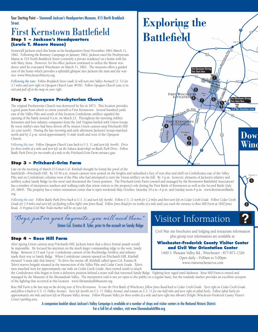
Stop 1 ~ Jackson’s Headquarters (Lewis T. Moore House)Stonewall Jackson used this home as his headquarters from November 1861-March 11, 1862. Following the Romney Campaign in January 1862, Jackson used the Presbyterian Manse at 319 North Braddock Street (currently a private residence) as a home with his wife Mary Anna. However, for his office Jackson continued to utilize the Moore resi-dence until he evacuated Winchester on March 11, 1862. The museum offers a guided tour of the home which provides a splendid glimpse into Jackson the man and the war-rior. www.WinchesterHistory.org.
Following the tour: Follow Braddock Street south (it will turn into Valley Avenue/U.S. 11) for 3.7 miles and turn right on Opequon Church Lane (#706). Follow Opequon Church Lane to its end and pull off at the map on your right.
Stop 2 ~ Opequon Presbyterian ChurchThe original Presbyterian Church was destroyed by fire in 1873. This location provides a good point from which to orient yourself to First Kernstown. Several hundred yards east of the Valley Pike and south of this location Confederate artillery signaled the opening of the battle around 9 a.m. on March 23. Throughout the morning Ashby’s horsemen and four infantry companies from the 2nd Virginia battled with Union troops. By noon Ashby’s men had been driven off by sixteen Union cannon atop Pritchard’s Hill (to your north). During the late morning and early afternoon Jackson’s troops marched north and by 2 p.m. stood approximately ½ mile south and west of the Opequon Church.
Following the tour: Follow Opequon Church Lane back to U.S. 11 and turn left (north). Drive for three-tenths of a mile and turn left (at the Subaru dealership) on Battle Park Drive. Follow Battle Park Drive for two-tenths of a mile to the Pritchard-Grim Farm entrance gate.
Stop 3 ~ Pritchard-Grim FarmLate on the morning of March 23 Union Col. Kimball thought he found the jewel of the battlefield—Pritchard’s Hill. By 10:30 a.m. sixteen cannon were posted on the heights and unleashed a fury of iron shot and shell on Confederates east of the Valley Pike and on Confederate columns west of the Pike who had attempted to turn the Union artillery on the hill. By 3 p.m., however, elements of Jackson’s infantry and artillery scaled Sandy Ridge (to the west) and threatened the Union position. The Pritchard-Grim Farm (owned and managed by the Kernstown Battlefield Association) has a number of interpretive markers and walking trails that orient visitors to the property’s role during the First Battle of Kernstown as well as the Second Battle (July 24, 1864). The property has a visitor orientation center that is open weekends May-October, Saturday 10 a.m.-4 p.m. and Sunday noon-4 p.m. www.KernstownBattle.org.
Following the tour: Follow Battle Park Drive back to U.S. 11 and turn left (north). Follow U.S. 11 north for 1.2 miles and then turn left on Cedar Creek Grade. Follow Cedar Creek Grade for 1.9 miles and turn left (at flashing yellow light) onto Jones Road. Follow Jones Road for six-tenths of a mile until you reach the entrance to Rose Hill Farm at 1850 Jones Road. A Virginia Civil War Trails marker will be on your left.
Stop 4 ~ Rose Hill FarmAfter spying Union cannon atop Pritchard’s Hill, Jackson knew that a direct frontal assault would be impossible. He focused his attention on the much larger commanding ridge to the west, Sandy Ridge. Between 2:15 and 3 p.m. Confederate cannon of the Rockbridge Artillery and infantry made their way to Sandy Ridge. When Confederate cannon opened on Pritchard’s Hill, Kimball shouted “I must take that battery.” To drive the enemy off, Kimball called upon Col. Erastus B. Tyler’s reserve brigade situated at the intersection of the Valley Pike and Cedar Creek Grade. Tyler’s men marched west for approximately one mile on Cedar Creek Grade, then turned south to attack the Confederates who began to form a defensive position behind a stone wall that traversed Sandy Ridge. Fighting here raged until darkness. Rose Hill Farm is owned and managed by the Museum of the Shenandoah Valley. The interpretive trail is not yet open to the public on a regular basis, but the roadside marker provides an excellent synopsis of the fighting that occurred at this location. www.ShenandoahMuseum.org.
Rose Hill Farm is the last stop on the driving tour of First Kernstown. To tour the First Battle of Winchester, follow Jones Road back to Cedar Creek Grade. Turn right on Cedar Creek Grade and follow it back to U.S. 11 (Valley Avenue). Turn left (north) on U.S. 11 (Valley Avenue) and remain on U.S. 11 for one-half mile and turn right on Jubal Early. Follow Jubal Early for approximately one mile and turn left on Pleasant Valley Avenue. Follow Pleasant Valley for three-tenths of a mile and turn right into Abram’s Delight (Winchester-Frederick County Visitor’s Center) parking area.
First Kernstown BattlefieldTour Starting Point ~ Stonewall Jackson’s Headquarters Museum, 415 North Braddock Street.
“Boys, put on your bayonets…you will need them.” Union Col. Erastus B. Tyler, prior to the assault on Sandy Ridge
A companion booklet about Jackson’s Valley Campaign is available at a number of shops and visitor centers in the National Historic District.For a full list of retailers, visit www.ShenandoahAtWar.org
3
5
1
2
4
10
8
9
67
11
81
81
8111
11
11
50
50
Senseny Rd
Val
ley
Ave
Mar
tinsb
urg
Pik
e
37
37
37
11
Jone
s R
d
522
522
BowersHill
BowersHill
Sand
y Ridg
eSa
ndy R
idge
Pritchard’sHill
Pritchard’sHill
R
edbud Rd
Exit 317
Exit 313
Exit 310
7
Milb
urn
Rd
Old Charles Town Road
FIRST WINCHESTER BATTLEFIELD
FIRST KERNSTOWN BATTLEFIELD
Plea
sant
Val
ley
Rd
Cedar Creek Grade (Rt. 622)
Middle Rd
Exit 315
CampHill
CampHill
Civil War Orientation Center
First Kernstown DrivingTour Starts Here
First Winchester DrivingTour Starts Here
Exploring the Battlefield
Amherst St
11
50
11
50
11
522
7
Piccadilly St
Boscawen St
Cork St
Handley Ave
Cam
eron
St
Loud
oun
St
Bra
ddoc
k S
t
Ken
t S
tWas
hing
ton
St
Ea
st L
n
Cam
eron
St
Loud
oun
St
Bra
ddoc
k S
t
Fai
rmon
t Ave
Pedestrian Mall
Downtown Historic District
Valley A
ve
Southwerk St
Juba l Ea r l y D r
Mi l lw
oo
d A
ve
1
9
6
Ramseur Ln
7
CampHill
CampHill
Bowers Hill
8
DowntownWinchester
Visitor InformationCivil War site brochures and lodging and restaurant information
plus group tour information are available at:
Winchester-Frederick County Visitor Center and Civil War Orientation Center
1400 S. Pleasant Valley Rd., Winchester - 877-871-1326Open daily - 9:00am to 5:00pm
www.visitwinchesterva.com
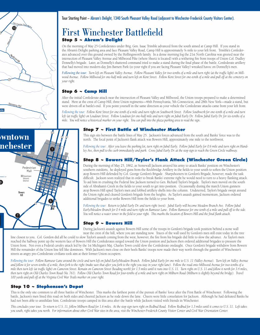
First Winchester BattlefieldTour Starting Point ~ Abram’s Delight, 1340 South Pleasant Valley Road (adjacent to Winchester-Frederick County Visitors Center).
Stop 5 ~ Abram’s DelightOn the morning of May 25 Confederates under Brig. Gen. Isaac Trimble advanced from the south aimed at Camp Hill. If you stand in the Abram’s Delight parking area and face Pleasant Valley Road, Camp Hill is approximately ¼ mile to your left front. Trimble’s Confeder-ates advanced over this ground owned by the Hollingsworth family. In a dense morning fog the 21st North Carolina was greeted near the intersection of Pleasant Valley Avenue and Millwood Pike (where Sheetz is located) with a withering fire from troops of Union Col. Dudley Donnelly’s brigade. Later, as Donnelly’s shattered command tried to make a stand during the final phase of the battle, Confederate artillery that had moved into modern-day Jim Barnett Park (to your right if you are facing Pleasant Valley) wreaked havoc on Donnelly’s men.
Following the tour: Turn left on Pleasant Valley Avenue. Follow Pleasant Valley for two-tenths of a mile and turn right (at the traffic light) on Mill-wood Avenue. Follow Millwood for one-half mile and turn left on Kent Street. Follow Kent Street for one-tenth of a mile and pull off at the cemetery on your right.
Stop 6 ~ Camp HillAfter the initial Confederate attack near the intersection of Pleasant Valley and Millwood, the Union troops prepared to make a determined stand. Here at the crest of Camp Hill, three Union regiments—46th Pennsylvania, 5th Connecticut, and 28th New York—made a stand, but were driven off at battle’s end. If you point yourself in the same direction as your vehicle the Confederate attacks came from your left front.
Following the tour: Follow Kent Street for one-tenth of a mile and turn right on Southwerk Street. Follow Southwerk for one-tenth of a mile and turn left (at traffic light) on Loudoun Street. Follow Loudoun for one-half mile and turn right on Jubal Early Dr. Follow Jubal Early Dr. for six-tenths of a mile. You will notice a historical marker on your right. You can pull into the plaza parking area to read the sign.
Stop 7 ~ First Battle of Winchester MarkerThis sign sits between the battle lines of May 25. Jackson’s forces advanced from the south and Banks’ force was to the north. The focal point of Jackson’s flank attack was Bowers Hill, approximately one mile to the northwest.
Following the tour: After you leave the parking lot, turn right on Jubal Early. Follow Jubal Early for 0.6 mile and turn right on Hand-ley Ave, then pull to the curb immediately and park. Cross Jubal Early Dr. at the stop sign to reach the Green Circle walkway.
Stop 8 ~ Bowers Hill/Taylor’s Flank Attack (Winchester Green Circle)During the morning of May 25, 1862, as Stonewall Jackson arrayed his army to attack Banks’ position on Winchester’s southern outskirts, he deployed guns from the Rockbridge Artillery in the fields to your south to soften the Union position atop Bowers Hill defended by Col. George Gordon’s Brigade. Sharpshooters in Gordon’s Brigade, however, made the task difficult. Jackson soon realized that in order to break Banks’ extreme right he would need to turn to a heavy flanking attack. To aid him in crushing the Federal line Jackson turned to Gen. Richard Taylor’s brigade. Taylor’s men moved on the south side of Abraham’s Creek in the fields to your south to get into position. Occasionally during the march Union gunners atop Bowers Hill spied Taylor’s men and lobbed artillery shells into the column. Undeterred, Taylor’s brigade swept around the Union right and cleared Gordon’s brigade from the heights. As Taylor’s assault gained momentum, Jackson ordered additional brigades to strike Bowers Hill from the fields to your front.
Following the tour: Return to Jubal Early Dr. and turn right (west). Jubal Early will become Meadow Branch Ave. Follow Jubal Early/Meadow Branch for 0.4 mile and turn right on Ramseur Lane. Follow Ramseur for one-tenth of a mile and pull off to the side. You will notice a water tower in the field to your right. This marks the location of Bowers Hill and the final flank attack.
Stop 9 ~ Bowers HillDuring Jackson’s assault against Bowers Hill some of the troops in Gordon’s brigade took position behind a stone wall near the crest of the hill, where you are standing now. Traces of the wall used by Gordon’s men still exist today in the tree
line closest to you. Col. Gordon did all he could to slow Taylor’s assault coming from the west, however, the fire from his brigade did little to slow the advance. As Taylor’s men reached the halfway point up the western face of Bowers Hill the Confederates surged toward the Union position and Jackson then ordered additional brigades to pressure the Union front. Not even a Federal cavalry attack led by the 1st Michigan’s Maj. Charles Town could slow the Confederate onslaught. Once Gordon’s brigade withdrew from Bowers Hill the remainder of the Union line fell like dominoes. With Jackson’s men close on their heels Banks’ troops now made their way north through the gauntlet of Winchester’s streets as angry pro-Confederate civilians took aim at their former Union occupiers.
Following the tour: Follow Ramseur Lane around the circle and turn left on Jubal Early/Meadow Branch. Follow Jubal Early for one mile to U.S. 11 (Valley Avenue). Turn left on Valley Avenue and follow it for seven-tenths of a mile, then fork to the right (make sure that after you fork to the right you stay in your right lane). Follow the road onto Millwood Avenue for two-tenths of a mile then turn left (at traffic light) on Cameron Street. Remain on Cameron Street (heading north) for 1.5 miles until it runs into U.S. 11. Turn right on U.S. 11 and follow it north for 3.4 miles, then turn right on Old Charles Town Road (Va. 761). Follow Old Charles Town Road for four-tenths of a mile and turn right on Milburn Road (Milburn is slightly beyond the bridge). Travel 100 yards and pull off at the Virginia Civil War Trails marker on your right.
Stop 10 ~ Stephenson’s DepotThis is the only site common to all three battles of Winchester. This marks the farthest point of the pursuit of Banks’ force after the First Battle of Winchester. Following the battle, Jackson’s men lined this road on both sides and cheered Jackson as he rode down the lane. Cheers were little consolation for Jackson. Although he had defeated Banks he had not been able to annihilate him. Confederate troops camped in this area after the battle while Jackson visited with friends in Winchester.
This concludes your tour. To return to U.S. 11, follow Milburn Road for 1.6 miles. At the stop sign turn right on Redbud Road. Follow Redbud for 1.3 miles until it comes to U.S. 11. Left takes you south, right takes you north. For information about other Civil War sites in the area, visit the Winchester-Frederick County Visitor Center and Civil War Orientation Center.
3
5
1
2
4
10
8
9
67
11
81
81
8111
11
11
50
50
Senseny Rd
Val
ley
Ave
Mar
tinsb
urg
Pik
e
37
37
37
11
Jone
s R
d
522
522
BowersHill
BowersHill
Sand
y Ridg
eSa
ndy R
idge
Pritchard’sHill
Pritchard’sHill
R
edbud Rd
Exit 317
Exit 313
Exit 310
7
Milb
urn
Rd
Old Charles Town Road
FIRST WINCHESTER BATTLEFIELD
FIRST KERNSTOWN BATTLEFIELD
Plea
sant
Val
ley
Rd
Cedar Creek Grade (Rt. 622)
Middle Rd
Exit 315
CampHill
CampHill
Civil War Orientation Center
First Kernstown DrivingTour Starts Here
First Winchester DrivingTour Starts Here
Amherst St
11
50
11
50
11
522
7
Piccadilly St
Boscawen St
Cork St
Handley Ave
Cam
eron
St
Loud
oun
St
Bra
ddoc
k S
t
Ken
t S
tWas
hing
ton
St
Ea
st L
n
Cam
eron
St
Loud
oun
St
Bra
ddoc
k S
t
Fai
rmon
t Ave
Pedestrian Mall
Downtown Historic District
Valley A
ve
Southwerk St
Juba l Ea r l y D r
Mi l lw
oo
d A
ve
1
9
6
Ramseur Ln
7
CampHill
CampHill
Bowers Hill
8
DowntownWinchester
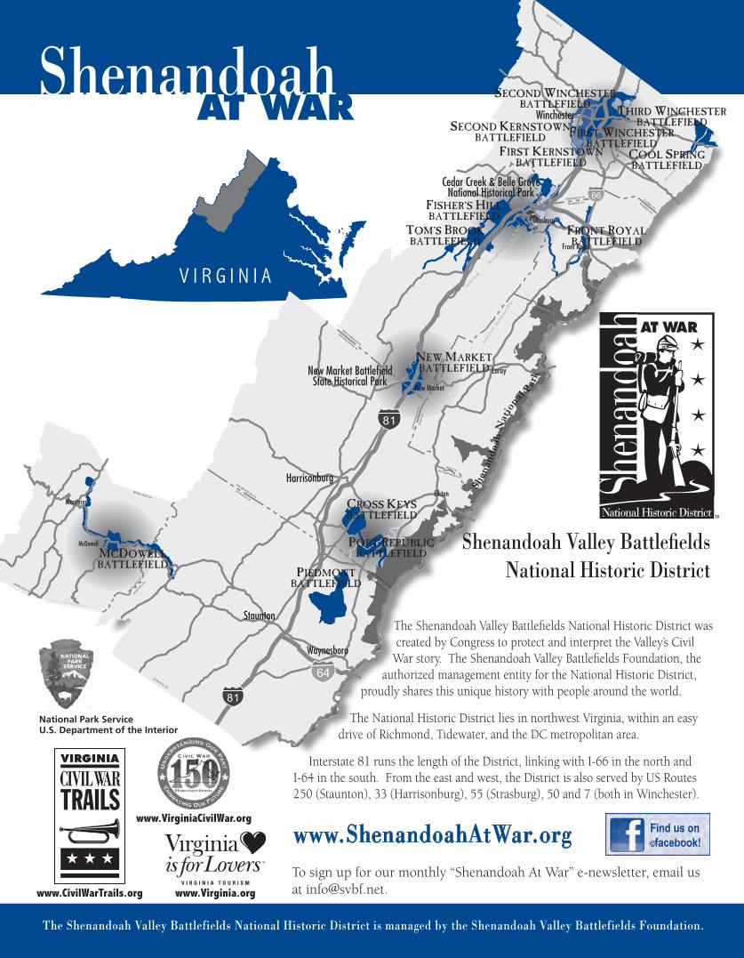
The Shenandoah Valley Battlefields National Historic District is managed by the Shenandoah Valley Battlefields Foundation.
Shenandoah Valley Battlefields National Historic District
AT WARShenandoah
The Shenandoah Valley Battlefields National Historic District was created by Congress to protect and interpret the Valley’s Civil
War story. The Shenandoah Valley Battlefields Foundation, the authorized management entity for the National Historic District,
proudly shares this unique history with people around the world.
The National Historic District lies in northwest Virginia, within an easy drive of Richmond, Tidewater, and the DC metropolitan area.
Interstate 81 runs the length of the District, linking with I-66 in the north and I-64 in the south. From the east and west, the District is also served by US Routes 250 (Staunton), 33 (Harrisonburg), 55 (Strasburg), 50 and 7 (both in Winchester).
www.ShenandoahAtWar.orgwww.VirginiaCivilWar.org
www.CivilWarTrails.org www.Virginia.org
National Park ServiceU.S. Department of the Interior
To sign up for our monthly “Shenandoah At War” e-newsletter, email us at [email protected].
V I R G I N I A
Strasburg
Front Royal
Luray
Elkton
McDowell
Harrisonburg
Waynesboro
Staunton
Winchester THIRD WINCHESTERBATTLEFIELD
FIRST WINCHESTERBATTLEFIELD
SECOND WINCHESTERBATTLEFIELD
SECOND KERNSTOWNBATTLEFIELD
TOM’S BROOKBATTLEFIELD
NEW MARKETBATTLEFIELD
CROSS KEYSBATTLEFIELD
PORT REPUBLICBATTLEFIELD
FISHER’S HILLBATTLEFIELD
FIRST KERNSTOWNBATTLEFIELD
FRONT ROYALBATTLEFIELD
COOL SPRINGBATTLEFIELD
New Market BattlefieldState Historical Park
Cedar Creek & Belle GroveNational Historical Park
New Market
Monterey
MCDOWELLBATTLEFIELD
PIEDMONTBATTLEFIELD