Willowmoor Floodplain Restoration Project Kick-Off Meeting ... · Project Kick-Off Meeting June 27,...
33
1 Willowmoor Floodplain Restoration Project Kick-Off Meeting June 27, 2013 Clise Mansion, Marymoor Park
Transcript of Willowmoor Floodplain Restoration Project Kick-Off Meeting ... · Project Kick-Off Meeting June 27,...

1
Willowmoor Floodplain Restoration Project Kick-Off Meeting
June 27, 2013
Clise Mansion, Marymoor Park

Presentation Overview Project Area History &
Context Transition Zone
Maintenance Willowmoor Project
Purpose & Goals Project Scope Funding & Schedule Public Involvement
2

Project Area History & Context
3

Sammamish River
4 Project Site

Transition Zone
Marymoor Park
Lake Sammamish
5
Bear Cr.

6

Low Flow Channel
Willow Buffer
High Flow Channel
7
Transition Zone
Weir

Early Sammamish River
Meandered through large wetland complex
River channel very shallow, with frequent logs and log jams
Flooding was common Floodplain wetlands provided storage
for flood waters
8
Known as “Squak Slough” Traditional hunting
and fishing area for Native Americans

Late 1800’s – Mid 1900’s
Floodplain cleared and developed for homesteads and farming
Logs and log jams removed for improved navigation
Floodplain ditched and drained for farming River channel straightened Chronic flooding of farm fields during spring
run-off 9
Period of European settlement
Logging in surrounding forests

1964 Army Corps Project
Project Elements: Deepened river channel Further straightened the river channel Reconstructed river banks Constructed Transition Zone to control flows
into Sammamish River channel Constructed weir at upstream end of TZ
10
Project Goals: Prevent spring-time
flooding of Sammamish Valley ag-lands
Provide more control of Lake Sammamish water levels

Post 1964 Channel Modifications River Scale
1990’s Salmon Habitat Enhancements 1990’s Sensitive Area’s Ordinance + imminent listing Chinook
Habitat Related Enhancements Example: Mammoth Sammamish: King County, City of Redmond,
USACE Projects addressed high water temperatures and lack of structural
diversity Innovative methods to increase vegetation while maintaining flood
capacity 2002 Sammamish River Corridor Action Plan – Path Forward
King County, USACE 11

12
1990’s Transition Zone modifications 1998 weir rebuild included Chinook low-flow fish passage Dog exclusion fencing and re-vegetation projects Willow buffer allowed to grow Reduced intensity of mowing banks
2003 Willowmoor Conceptual Report Long term plan to provide better flood and habitat benefits Similar goals as current project Smaller study area Data, analyses and design concepts will be used as
appropriate in current effort
Post 1964 Channel Modifications Transition Zone

13
2000’s Lake Water Surface Elevation
• Increasing trend of high water surface elevation on Lake Sammamish from 1990’s to 2000’s
• Lake Sammamish Food Reduction Plan - 2011
• Increase mowing on banks and removing clippings • Trim willow buffer and restore navigation channel • Remove aquatic weeds (Brazilian elodea) • Evaluate sediment removal • Monitor plan effectiveness • Re-invigorate Willowmoor effort as long term
solution

BEFORE AFTER
Sammamish River Transition Zone 2011 Vegetation Maintenance: Before/After Photo Monitoring
Photo 5 before, left bank buffer missing willow, no navigation issue, weir found.
Photo 5 after, no trimming, willow planted on left bank, weir reported and surveyed.
Photo 6 before, both bank buffers >> 10 feet, encroaching on navigation
Photo 6 after, both banks trimmed, buffer width and navigable channel
Log revealed
Weir found
14

15
2000’s Lake Water Surface Elevation
• Increasing trend of high water surface elevation on Lake Sammamish from 1990’s to 2000’s
• Lake Sammamish Food Reduction Plan - 2011 Increase mowing on banks and removing clippings Trim willow buffer and restore navigation channel • Remove aquatic weeds (Brazilian elodea) • Evaluate sediment removal Monitor plan effectiveness Re-invigorate Willowmoor effort as long term
solution

Willowmoor = Long term Maintenance Solution
Develop better site design for the flood project in order to address modern regulatory environment and support salmon recovery
Reduce maintenance costs by installing a design that addresses multiple benefit river management
16

Willowmoor Floodplain Restoration Project
17

Project Goals Design: Provide effective, sustainable flood control Reduce maintenance Enhance habitat
Process: Effectively communicate with public Engage stakeholders in project development
18

19
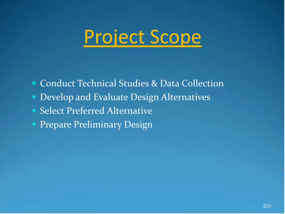
Project Scope
Conduct Technical Studies & Data Collection Develop and Evaluate Design Alternatives Select Preferred Alternative Prepare Preliminary Design
20

Technical Studies and Data Collection
Conduct suite of technical studies to: Characterize project site Identify opportunities & constraints Establish design criteria
Prepare “Basis of Design” report
21
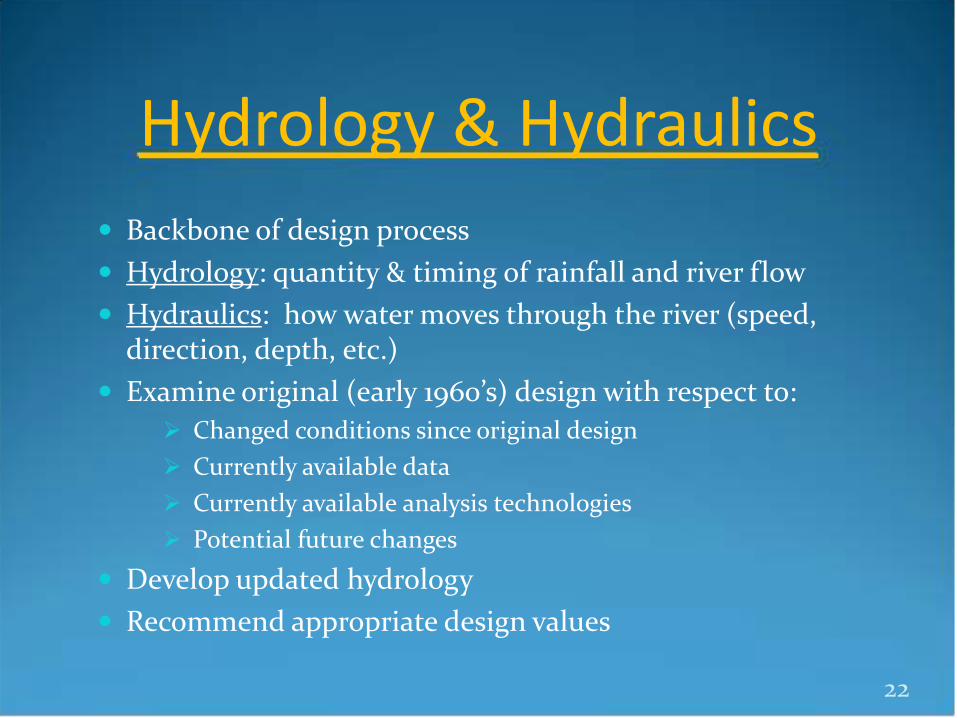
Hydrology & Hydraulics Backbone of design process Hydrology: quantity & timing of rainfall and river flow Hydraulics: how water moves through the river (speed,
direction, depth, etc.) Examine original (early 1960’s) design with respect to:
Changed conditions since original design Currently available data Currently available analysis technologies Potential future changes
Develop updated hydrology Recommend appropriate design values
22

Habitat / Water Quality Identify Land Use Restrictions on Parks Property Wetland and Vegetation Mapping Stream Corridors and Connectivity
Identify opportunities and constraints for improving riparian and wetland habitat connectivity
Cold Water Sources Develop planning level sketches and estimates for a variety of
cold water sources Fish and Wildlife
Identify opportunities and constraints for habitat improvement for listed species and others
WRIA 8 goals and 2002 Sammamish Corridor Action Plan goals
23

Public Access & Recreation
Consideration of existing uses (dog park, rowing, walking, bird-watching, etc.)
Public access potential on southwest (left) bank Safety and access for water users Improved conditions for passive recreation
24
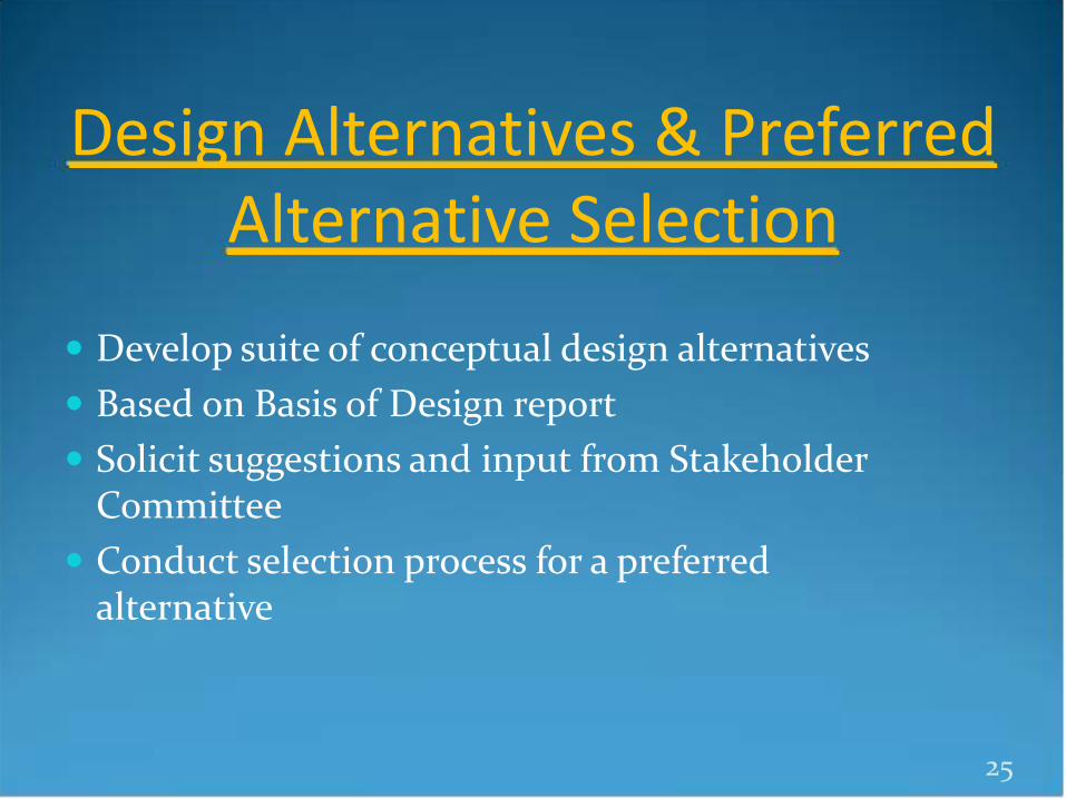
Design Alternatives & Preferred Alternative Selection
Develop suite of conceptual design alternatives Based on Basis of Design report Solicit suggestions and input from Stakeholder
Committee Conduct selection process for a preferred
alternative
25

Preliminary Design
Further develop design of the preferred alternative
Prepare more detailed cost-estimate Permit ready plan set Suitable for grant applications.
26

Project Funding
Current Project Phase funded by KC-FCD, including $150K opportunity funding
from Redmond
Future Project Phases
will likely be a combo of KC-FCD funds + habitat restoration grants
Will fund final design, permitting and construction
27

Partners & Stakeholders Partnership between KC-FCD, KC-DNRP (Parks & Rivers)
and City of Redmond Large variety of stakeholders representing diverse set of
interests:
28
Park users Lake property owners River valley property
owners Environmental interests Tribes
Municipalities Local, state and federal
agencies Businesses Public at large.

Project Schedule
Tech Studies & Data Collection Now – Dec 2013
Alternatives Development & Selection Jan– Jun 2014
Preliminary Design Jul – Dec 2014
29

Communications & Public Involvement
Website Mailings Public Meetings Stakeholder Advisory Committee
30

Stakeholder Advisory Committee Purpose & Roles
Represent their organization’s positions and interests related to design of the project;
Exchange information and ideas with the project team and other stakeholders;
Assist with the creation of design goals and criteria; Help to develop project alternatives; Disseminate information about the project to their
membership or peers; and Provide a public voice to help guide the project toward
implementation.
31

Stakeholder Advisory Committee Meeting Topics & Schedule
Jun 27, 2013 Public Mtg #1: Project Kick-off
Jul 2013 Stakeholder Mtg #1: Committee Kick-off
Aug – Oct 2013 Stakeholder Mtg s #2-3: Discuss project criteria/review tech studies
Nov – Dec 2013 Stakeholder Mtg #4: Brainstorm on Project Alternatives Concepts
Jan 2014 Public Mtg #2: Technical Studies Results / Intro of Early Concepts
Feb – May 2014 Stakeholder Mtg #5-6: Further Development of Project Alternatives
Jul 2014 Stakeholder Mtg #7: Discussion of Alternative Selection
Aug 2014 Public Mtg #3: Presentation of Preferred Alternative
32

Thank you!
33