Wildland Fire Management Information (WFMI) Weather Lesson 5: Station Information April 2014.
21
Wildland Fire Management Information (WFMI) Weather Lesson 5: Station Information April 2014
-
date post
19-Dec-2015 -
Category
Documents
-
view
215 -
download
0
Transcript of Wildland Fire Management Information (WFMI) Weather Lesson 5: Station Information April 2014.

Wildland Fire Management Information (WFMI) WeatherLesson 5: Station Information
April 2014

WFMI Weather
Select Station link in WFMI Weather

Select Station
A station can be selected from this list or the Change Selection Criteria button can be chosen. More
information about Select Station is in Lesson 4.

Station Page
The Station page displays the station’s metadata. Depending on permissions, buttons to view/edit are available.

Station InformationThe top left side of the Station page shows some basic
information about the station.
The Last Observation shows the last time data was transmitted from the station and received by WFMI weather.
If the field is red, observations are not current in WFMI.
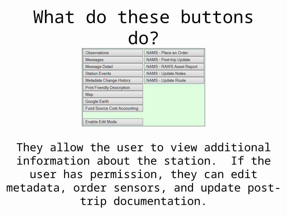
What do these buttons do?
They allow the user to view additional information about the station. If the user has permission, they can edit metadata,
order sensors, and update post-trip documentation.

Observations
Shows the last 24 hours of observations from the station.
User can change selection.Click for
more information

Messages
Information about the transmission of data from the station through the GOES satellite

Message Detail
Header information about GOES transmission and the raw data (Message) from the station

Station Events
Station events describe data transmission errors and anomalous events

Metadata Change History
All edits/changes to the station metadata are recorded in WFMI Weather, including the data and time, the user who
made the change, and what was changed.

Print Friendly Description
Station metadata in a format that can be printed.

Map
The map shows the location of the station.

Google Earth
• This allows the user to create a file showing the location of the station, which may then be opened in Google Earth.

Edit Mode
• Enable Edit Mode
• Edit Metadata• Commit Changes
If the user has edit access to the station, the Enable Edit Mode will allow editing for fields that permission has
been granted, based on Role.

NAMS
• WFMI Weather module is linked to National Interagency Fire Center (NIFC) Asset Management System (NAMS)
• User can perform tasks through WFMI Weather interface

NAMS – Place an Order
• The steps for this are discussed in lesson 6.

NAMS – Post-trip Update
• The steps for this are discussed in lesson 7.

NAMS – RAWS Asset Report
The asset report includes information about the station, including site description, notes, narrative, route, and
sensors. One or more email addresses can be entered to receive an asset report.

NAMS – Update Notes
Notes contain site-specific information such as uncommon sensors, lack of standard sensors, special access procedures,
precautions, etc. The information in notes is not visible outside of WFMI and can only be seen by user who has edit access to the station. Notes page allows the option to email an asset report. Once changes are made, update or cancel.
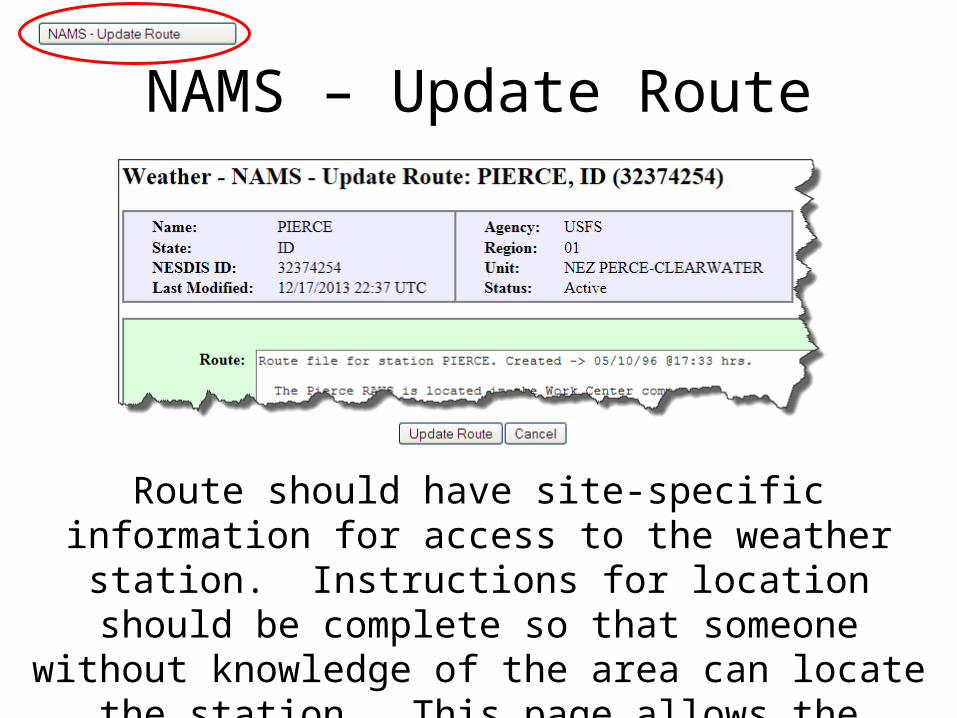
NAMS – Update Route
Route should have site-specific information for access to the weather station. Instructions for location should be
complete so that someone without knowledge of the area can locate the station. This page allows the option to email an asset report. Once changes are made, update or cancel.