WIDESPREAD PEGMATITE-HOSTED LITHIUM AND TIN · PDF fileWIDESPREAD PEGMATITE-HOSTED LITHIUM AND...
29
ASX Announcement 10 November 2017 ABN 45 600 308 398 Level 1 282 Rokeby Road Subiaco WA 6008 | PO Box 2019 Subiaco WA 6904 P +61 8 9327 0950 | F +61 8 9327 0901 | E [email protected] www.trrltd.com.au WIDESPREAD PEGMATITE-HOSTED LITHIUM AND TIN POTENTIAL OUTLINED AT SOLDIERS CREEK PROJECT, NT Three new lithium prospects outlined by mapping and sampling at Soldiers Creek, located south of the Bynoe Lithium Field – currently being explored by multiple companies HIGHLIGHTS • Results received from maiden mapping and sampling program over the recently granted Soldiers Creek Project, located west of Katherine and south of the Bynoe Lithium Field in the Northern Territory. • Three new lithium prospects outlined with the Muldiva and Buldiva areas returning: o Rock chip results to 2,235ppm Li2O, 1,400ppm Ta, 431ppm Cs, and 331ppm Nb; o 800m of strike with anomalous pXRF soil results for Sn, and other Li-related elements; o Up to 75% SnO2 (tin) in pan concentrates, with eight samples averaging 52%; and o Very high tin content in alluvium • The Collia area has: o 800x1500m of abundant sheeted pegmatite exposed within the Soldiers Creek Granite; o Rock chip results to 1,636ppm Li2O, and 632ppm Cs; o Pan Concentrate tin values up to 54% SnO2; and o Highly anomalous REE values in concentrates 1.22% Ce, 5930ppm Y, 6070ppm La and 4870ppm Nd • Further mineralogical work is in progress, prior to planning a 2018 program Todd River Resources Limited (ASX: TRT) is pleased to advise that it has outlined three extensive pegmatite-hosted lithium prospects with very high tin values at the recently granted Soldiers Creek Project area, located west of Katherine in the Northern Territory (Figure 1). The Soldiers Creek EL 31209 covers 181 blocks, some 160km to the south of Darwin and west of Katherine. The tenement was granted to Todd River in December 2016, clearing the way for it to undertake the first-ever field program at the project in September. The tenement covers most of the Wingate Mountain pegmatite district of the Litchfield pegmatite belt within the Pine Creek Orogen of Paleoproterozoic rocks. The Bynoe pegmatite field, which lies to the north, has had significant lithium exploration work conducted on it over the last two years by companies such as Core Exploration (ASX: CXO), Liontown Resources (ASX: LTR), and Kingston Resources (ASX: KSN).
Transcript of WIDESPREAD PEGMATITE-HOSTED LITHIUM AND TIN · PDF fileWIDESPREAD PEGMATITE-HOSTED LITHIUM AND...

ASX Announcement 10 November 2017
ABN 45 600 308 398 Level 1 282 Rokeby Road Subiaco WA 6008 | PO Box 2019 Subiaco WA 6904 P +61 8 9327 0950 | F +61 8 9327 0901 | E [email protected] www.trrltd.com.au
WIDESPREAD PEGMATITE-HOSTED LITHIUM AND TIN
POTENTIAL OUTLINED AT SOLDIERS CREEK PROJECT, NT Three new lithium prospects outlined by mapping and sampling at Soldiers Creek, located
south of the Bynoe Lithium Field – currently being explored by multiple companies
HIGHLIGHTS
• Results received from maiden mapping and sampling program over the recently granted Soldiers Creek Project, located west of Katherine and south of the Bynoe Lithium Field in the Northern Territory.
• Three new lithium prospects outlined with the Muldiva and Buldiva areas returning:
o Rock chip results to 2,235ppm Li2O, 1,400ppm Ta, 431ppm Cs, and 331ppm Nb; o 800m of strike with anomalous pXRF soil results for Sn, and other Li-related
elements; o Up to 75% SnO2 (tin) in pan concentrates, with eight samples averaging 52%; and o Very high tin content in alluvium
• The Collia area has:
o 800x1500m of abundant sheeted pegmatite exposed within the Soldiers Creek
Granite; o Rock chip results to 1,636ppm Li2O, and 632ppm Cs; o Pan Concentrate tin values up to 54% SnO2; and o Highly anomalous REE values in concentrates
1.22% Ce, 5930ppm Y, 6070ppm La and 4870ppm Nd
• Further mineralogical work is in progress, prior to planning a 2018 program Todd River Resources Limited (ASX: TRT) is pleased to advise that it has outlined three extensive pegmatite-hosted lithium prospects with very high tin values at the recently granted Soldiers Creek Project area, located west of Katherine in the Northern Territory (Figure 1). The Soldiers Creek EL 31209 covers 181 blocks, some 160km to the south of Darwin and west of Katherine. The tenement was granted to Todd River in December 2016, clearing the way for it to undertake the first-ever field program at the project in September. The tenement covers most of the Wingate Mountain pegmatite district of the Litchfield pegmatite belt within the Pine Creek Orogen of Paleoproterozoic rocks. The Bynoe pegmatite field, which lies to the north, has had significant lithium exploration work conducted on it over the last two years by companies such as Core Exploration (ASX: CXO), Liontown Resources (ASX: LTR), and Kingston Resources (ASX: KSN).

2
Earlier this year, Core Exploration defined the first Lithium Mineral Resource in the Northern Territory at the Grants Prospect. It has also recently purchased Liontown’s tenure in the Bynoe Field for $3.5 million (cash plus shares), with a further $1.5 million payable on the definition of a Mineral Resource exceeding 5 million tonnes (see Liontown’s ASX release on 14 September 2017).
Figure 1. Location of the Soldiers Creek Project, showing the three prospect areas mapped. Three historical tin mining centres are located on the southern portion of the Wingate Mountain district, and within EL 31209. The Muldiva and Buldiva historical tin mining centres are immediately west of the Fish River homestead, while the Collia (Collah) tin field is near the southern boundary of the licence (Figure 1). Historical tin and tantalum mining in these areas was predominantly from both alluvial (creek sand) and eluvial (soil) material, with only minor production from pegmatite.

3
Production resulted in cassiterite (a tin oxide mineral) and a smaller amount of tantalite (Fe-Mn tantalum oxide mineral) concentrates being produced. Recorded historical tin production from these three tin fields was 45.7 tonnes. Program of Work Completed Todd River completed an initial program of geological mapping and sampling over the three prospect areas during September. A full assessment of the results received is provided below. Geological Mapping Geological mapping was completed over all historical mining areas and covered the extent of the known pegmatite. Collia has the most extensive area of workings and mapping covering an area of 2.5km x 1.5km area for 2.3km2 (Figure 2). Buldiva and Muldiva (Figure 3) were combined as the main workings were almost along strike from each other. In total, at Muldiva/Buldiva a strike length of 1,500 metres was mapped. The country rock over much of the tenement is the Burrell Creek Formation of the Finiss River Group, which forms the western margin sequence of the Pine Creek Orogen. The same sequence hosts many of the Bynoe Sn-Ta-Li pegmatites, some 150km to the north. The Burrell Creek Formation in the mapped areas comprises greenschist facies metamorphosed turbidites – siltstones, phyllites and schists, which have been tightly folded along NW striking axes as part of the Litchfield Event ca. 1850Ma. The tin and tantalum mineralisation at Collia and Buldiva/Muldiva is genetically and spatially associated with the Soldiers Creek Granite, which crops out along the western side of the tenement and over much of the Collia mining area. It is a differentiated granite forming part of the Allia Creek Suite of peraluminous S-type granites. Pegmatites bearing tin, tantalum and lithium form a late phase related to the granite intrusion, being focussed at the apical or roof zones of granites where incompatible elements are concentrated both within and exterior to the granite. Pegmatites comprise mostly: albite and microcline feldspars, quartz, and muscovite. The presence of spodumene has been confirmed (in 20-40% of the pegmatites) on the Bynoe field by Core Exploration’s work over the last year. Generally with weathering to moderate depth (5-30+ metres) there is no fresh spodumene identifiable at surface, having, with the feldspars, been weathered to kaolinite clay. Accessory minerals, both in the pegmatites and in proximal altered-granite, include: cassiterite, tantalite, apatite, tourmaline, and fluorite. At Collia, most of the area with historical mining comprises granite sub-crop with much of the original soil/eluvium layer (up to two metres thick) removed and treated to recover heavy minerals in unconsolidated sand/soil material. Collia Geology Geological mapping over a 2.5km x 1.5km area at Collia outlined abundant pegmatites hosted by the Soldiers Creek Granite (Figure 2). To the west and north, Cretaceous and Tertiary sediments mask the prospective package. Historical alluvial mining activity appears to continue further to the south, outside of the tenement. Much of the historical processing of the alluvials appears to have been conducted on the Fish River and at the Collia waterhole, just east of the mapping area.

4
Figure 4. Collia geological mapping area. Low ridge of pegmatite and aplite. Within the central granite/pegmatite area, which has seen the most historical mining activity, outcrop is variable. Low hills are generally crested by aplitic or pegmatitic dykes and mostly strike north-east or NNE. Granite is exposed on hill flanks, and in creek exposures, and elsewhere there is a thin (<1m thick) residual granitic “grus” soil. Most exposures are only weakly to moderately weathered, and the weathering depth appears quite thin (a few to several metres). Pegmatites rarely exceed two metres thickness, but are abundant and frequently occur in sheeted sub-parallel swarms trending to the NNE or north-east, and dipping shallowly to the north-west. Several small (to 200m long) outcrops of the Burrell Creek Formation occur over the area, indicating that the whole area is on the granite stock roof (pendant zone), where the most fractionation would have occurred. The area mapped is the extreme southern extent of the Soldiers Creek Granite. It is wrapped and bound, to the west and south, by the regional Collia Fault. Historical mining has covered a significant area, some 1500m x 1200m. The area has ca. 20m of topography, with low ridges of reasonably fresh aplite/pegmatite/granite (Figure 4), flats with grus and thin (<1m) soils on weathered granite, and broad shallow creek lines with up to two metres of alluvium on basement outcrop.

5
There are several shallow creek lines up to 1km long traversing the area between the Fish River to the east and a tributary to the west. Mining appears to have been undertaken by front-end loader/excavator where all the alluvium was taken for processing from most of the creek lines in the area. Processing would have been via a screen and scrubber/trammel, and then heavy mineral collection by jigs and/or spirals. Buldiva/Muldiva Geology Both areas were mapped and have the main hard-rock target being a north-west striking pegmatite body which crops out intermittently for 600m at Buldiva (Figure 3) and over some 100m at Muldiva (Figure 5). There is a 150m offset between the strike of the two pegmatite zones, coinciding with an area of Cretaceous sandstone cover, with the Muldiva trend to the north-east of the strike line at Buldiva. This trend is open to both the north, where it goes under further Cretaceous cover, and to the south. The pegmatites noted are steeply-dipping, lenticular, up to 10m thick, and are predominantly quartz-muscovite types, with lesser amounts of feldspar noted (Figure 6). In addition to the main pegmatite line there are several smaller pegmatite and aplite zones (<1m thick) mapped, within a broad ca. 150m wide and 1500m long corridor. Pegmatite preferentially intrudes the less competent Burrell Creek Formation lithologies – phyllites and pelitic units. The far northernmost exposure of the Soldiers Creek Granite occurs some 150 metres to the west of the gap between Buldiva and Muldiva (Figure 3). A major sub-parallel fault to the east of the workings divides the Burrell Creek Formation from the younger Depot Creek Sandstone. Despite diggings up to 2m deep on pegmatite, essentially all mining from these two areas was of alluvium. Here the topography was greater with steep slopes and well defined narrow creeks containing only a modest alluvial load. Downslope/downstream material from all pegmatite outcrops appears to have been processed. There are three creek tributaries at Buldiva and a single creek line at Muldiva with evidence of mining. The amount of mined material would be considerably lower at Buldiva/Muldiva, compared to Collia.

6
Figure 5. Mapping and sampling at the Muldiva Prospect area, Soldiers Creek.
Figure 6. Part of the historic workings at the Buldiva Prospect area, Soldiers Creek.

7
Sampling Program 105 rock chip samples were collected and submitted for laboratory analysis while mapping progressed over the tenement. All areas of workings and the surrounds were soil sampled using a portable XRF unit, for 1080 analyses. A further 32 -80 mesh soil samples were submitted for laboratory analysis. 5-20kg of creek alluvium (8 from Buldiva, 1 from Muldiva, and 13 from Collia) was collected and then panned to generate a pan concentrate for analysis. Details of the sampling procedures can be found in Appendix A, while results for relevant elements are tabulated in Appendix B. Rock Chip Sampling 48 rock chip samples from the combined Buldiva and Muldiva area (Figure 3) were submitted for analysis along with 57 from Collia (Figure 2). 1-4kg rock samples were analysed at ALS for a lithium suite of elements by Na2O2 fusion and ICP-MS finish (details in Appendix A). Significant lithium assays include a 2235ppm Li2O result at Buldiva and a maximum value of 1636ppm Li2O at Collia. Support with the lithium is outlined in Table 1. Elevated values for caesium (Cs), niobium (Nb) and tantalum (Ta) in over 40 samples confirm that all pegmatite is of the highly prospective LCT (Lithium-Caesium-Tantalum) type. Results from other trace and major elements, such as elevated Rb, Sn, P, confirm this interpretation. Table 1. Maximum rock chip samples results for pegmatite related elements.
Soil Sampling Soil samples over the three prospect area were analysed with portable XRF (pXRF), for a total of 1080 analyses. Samples were of B horizon soil directly onto the ground surface at spacings of 25m along lines on lines 100m or 50m apart. Samples were determined on SOIL Mode with a 60 second read time. At Collia 729 analyses were obtained over a 2.0 sqkm area (Figure 7). At Buldiva/Muldiva an area of 0.4 sqkm was covered with 351 analyses (Figure 8). The Olympus Delta pXRF unit used does not analyse lithium, but several pegmatite-related elements can be determined and were used for anomaly and lithogeochemical discrimination mapping of the areas of Sn-Ta-Li pegmatite. Results (Appendix B) show the areas of pegmatites clearly outlined by >75ppm tin (Sn) results, as shown in Figures 7 and 8. At Collia, an area of 1800m x 800m was anomalous at the 75pppm Sn threshold, a total of 219 samples or 30% of the dataset for the area.
ROCK CHIP Maximum ValuesSAMPLING Li2O (ppm) Cs (ppm) Nb (ppm) Ta (ppm)Buldiva/ 2235 431 331 1400MuldivaCollia 1636 632 135 <100

8
800m of strike was anomalous at Buldiva and 150m at Muldiva, at the same threshold. There is broad but patchy support in the pXRF data from Nb and Ta, as would be expected of these incompatible elements. The 32 -80 mesh soil samples submitted to ALS were analysed for the same suite as the rock samples and broadly corroborated the pXRF values, if with minor variations in background/threshold values. The pXRF dataset has a much smaller sample size, and so is less representative and therefore suffers with more variable results. Pan Concentrate Sampling A total of 22 pan concentrate samples were collected, weighed, and then concentrated by panning (Figure 9) till a 10-150g concentrate was formed – one from Muldiva, eight from Buldiva and 13 from the Collia area. All were taken from active creek and non-trap sites. This was analysed by the same suite of elements as the rock samples, with results shown on Figures 2 and 3 and Appendix B. Samples from Buldiva had abundant cassiterite (SnO2) in the pan concentrates, with eight samples containing more than 20% cassiterite, in fact, the only other sample was taken from a creek that did not drain from the pegmatite area. The eight samples averaged 51.5% SnO2, with the highest value being 74.65% SnO2 in concentrate. Collia also had good high-grade tin-in-concentrate, not surprisingly given most of the creeks had been mined for cassiterite, with some lower values likely due to the removal of ore sands. Values ranged up to 54.21% SnO2, with four above 20% SnO2, and averaged 17% SnO2 in concentrate. The sands from Buldiva and Collia have a calculated sand content that is likely to be, for any reasonable tonnage, economic, with Collia still having significant tonnage potential. Average Tin Content Buldiva 0.196% SnO2 in alluvial material sampled Collia 0.012% SnO2 in alluvial material sampled Note: Average of the 8 and 12 samples (respectively) that drain areas of pegmatite. These
values are not intended to represent grade values, and no Mineral Resource has been determined.
While poorly recorded, historical alluvial tin mining in the Northern Territory had average mined grades in the range of 0.01 to 0.02% SnO2. Compared to these values the Buldiva creek sands are very high grade. Muldiva has a small pegmatite outcrop and a single creek with minimal alluvial load. The only alluvial sand sample able to be collected was taken some 400m down steam and had low cassiterite content. None of the lithium-bearing minerals will persist into alluvial material, as they break down to clays, which get eroded and washed away. Intriguingly, most of the Collia pan conc. samples returned highly anomalous rare earth element (REE) values, particularly the light REE. Maximum values of 12200ppm (1.22%) Cerium (Ce), 5930ppm yttrium (Y), 6070ppm lanthanum (La), and 4870ppm neodymium (Nd) highlight the area (Figure 10).

9
A REE-bearing mineral, such as monazite, allanite or xenotime, must be common in the Collia alluvium, having been derived from the decomposition of the underlying pegmatite and granite. Additional analyses and mineralogical determination work is ongoing. Discussion A relatively quick and cost effective program of mapping and sampling by Todd River at the Soldiers Creek project has outlined three areas of lithium-bearing pegmatites, in an area that has had no previous work focused on lithium. The existing tin mining activity provides a focus and indicates potential size of the lithium-bearing pegmatite system being greater in the vicinity of Collia. The elevated REE values also suggest the pegmatites could be of either REE-type, and offer another avenue for further work. Next Steps Additional analyses are awaited (XRD mineralogy) and petrographic and mineralogical will be done on the samples obtained during this field program, to confirm the lithium and rare-earth minerals present. Once assessed, follow-up work will be planned for early in the 2018 dry season. Paul E Burton Technical Director 10 November 2017

10
Figure 9. Pan concentrate from the Buldiva prospect area, with abundant cassiterite (black grains). Enquiries: Paul Burton, Technical Director + 61 (0) 8 9327 0950 Nicholas Read Read Corporate + 61 (0) 8 9388 1474 Competent Person Statement The information in this report that relates to Exploration Results is based on, and fairly represents, information and supporting documentation compiled by Exploration Manager Mr Kim Grey B.Sc. and M. Econ. Geol. Mr Grey is a member of the Australian Institute of Geoscientists, and an employee of Todd River Resources Limited. Mr Grey has sufficient experience relevant to the style of mineralisation and type of deposit under consideration and to the activity which he is undertaking to qualify as a Competent Person as defined in the 2012 Edition of the ‘Australasian Code for Reporting of Exploration Results, Mineral Resources and Ore Reserves’. Mr Grey consents to the inclusion in the report of the matters based on his information in the form and context in which it appear.

11
Forward-Looking Statements This announcement has been prepared by Todd River Resources Ltd. This announcement is in summary form and does not purport to be all inclusive or complete. Recipients should conduct their own investigations and perform their own analysis in order to satisfy themselves as to the accuracy and completeness of the information, statements and opinions contained. This is for information purposes only. Neither this nor the information contained in it constitutes an offer, invitation, solicitation or recommendation in relation to the purchase or sale of Todd River Resources Ltd shares in any jurisdiction. This does not constitute investment advice and has been prepared without taking into account the recipient's investment objectives, financial circumstances or particular needs and the opinions and recommendations in this presentation are not intended to represent recommendations of particular investments to particular persons. Recipients should seek professional advice when deciding if an investment is appropriate. All securities transactions involve risks, which include (among others) the risk of adverse or unanticipated market, financial or political developments. To the fullest extent permitted by law, Todd River Resources Ltd, its officers, employees, agents and advisers do not make any representation or warranty, express or implied, as to the currency, accuracy, reliability or completeness of any information, statements, opinions, estimates, forecasts or other representations contained in this announcement. No responsibility for any errors or omissions from this arising out of negligence or otherwise is accepted. This may include forward looking statements. Forward looking statements are only predictions and are subject to risks, uncertainties and assumptions which are outside the control of Todd River Resources Ltd. Actual values, results or events may be materially different to those expressed or implied. For more information please see the company’s website at www.trrltd.com.au

12
Figure 2. Collia area geological mapping showing
rock chip and pan concentrate sampling tin (Sn) results.

13
Figure 3. Buldiva and Muldiva area geological mapping showing
rock chip and pan concentrate sampling tin (Sn) results.

14
Figure 7. Collia area. pXRF soil sampling tin (Sn) results.

15
Figure 8. Buldiva and Muldiva area. pXRF soil sampling tin (Sn) results.

16
Figure 10. Collia area showing rock chip and pan concentrate sampling Light Rare Earth Element
(LREE) results. LREE = Lanthanum (La) + Cerium (Ce) + Praseodymium (Pr) + Neodymium (Nd) + Samarium (Sm) + Europium (Eu).

17
Appendix A - JORC Table One - Sampling Techniques and Data
Soldiers Creek – Rock Chip, pXRF Soils and Pan Concentrate Sampling
Criteria JORC Code explanation Commentary Sampling techniques Nature and quality of sampling (eg cut channels, random
chips, or specific specialised industry standard measurement tools appropriate to the minerals under investigation, such as down hole gamma sondes, or handheld XRF instruments, etc). These examples should not be taken as limiting the broad meaning of sampling. Include reference to measures taken to ensure sample representivity and the appropriate calibration of any measurement tools or systems used. Aspects of the determination of mineralisation that are Material to the Public Report.
B-horizon material was analysed by an Olympus Delta Professional portable XRF unit in the field. Sample sites were determined by GPS position. No sample preparation was conducted other than removing the A-horizon organic surface layer (up to 1 cm thick). 5-10kg alluvial samples were panned on site to a concentrate being 15-150g for analysis. 1-4kg Rock Chip samples taken. All samples submitted to ALS with industry standard crushing (rocks only) and pulverisation (>90% <75um).
Drilling techniques Drill type (eg core, reverse circulation, open-hole hammer, rotary air blast, auger, Bangka, sonic, etc) and details (eg core diameter, triple or standard tube, depth of diamond tails, face-sampling bit or other type, whether core is oriented and if so, by what method, etc).
Not relevant
Drill sample recovery Method of recording and assessing core and chip sample recoveries and results assessed. Measures taken to maximise sample recovery and ensure representative nature of the samples. Whether a relationship exists between sample recovery and grade and whether sample bias may have occurred due to preferential loss/gain of fine/coarse material.
Not relevant
Logging Whether core and chip samples have been geologically and geotechnically logged to a level of detail to support appropriate Mineral Resource estimation, mining studies and metallurgical studies. Whether logging is qualitative or quantitative in nature. Core (or costean, channel, etc) photography. The total length and percentage of the relevant intersections logged.
Soil sampling and pan concentrate sites were described briefly for: regolith type and lithology (if seen). Rock samples had a full geological description recorded. All logging was qualitative.
Sub-sampling techniques and sample preparation
If core, whether cut or sawn and whether quarter, half or all core taken. If non-core, whether riffled, tube sampled, rotary split, etc and whether sampled wet or dry. For all sample types, the nature, quality and appropriateness of the sample preparation technique. Quality control procedures adopted for all sub-sampling stages to maximise representivity of samples. Measures taken to ensure that the sampling is representative of the in situ material collected, including for instance results for field duplicate/second-half sampling. Whether sample sizes are appropriate to the grain size of the material being sampled.
All pXRF soil samples were of dry soil material dominated by fines (silt and clay material). No sub sampling was conducted. No field duplicate readings were taken. Standard samples (Certified for lithium, AMIS340, 341, and 342) and Blank samples (GLG312-2) were inserted into all sample batches. In total 55 standard determinations were made, along with 11 Blank analyses. Results were acceptable. Orientation soil sampling lines were conducted in all three areas to allow comparison of pXRF data with laboratory soil results. Results were broadly comparable and allowed anomalous thresholds to be determined in the pXRF data. Given the sample medium and the results of the orientation surveys the pXRF sample material is considered appropriate for the grain size and representative of the material sampled.

18
Criteria JORC Code explanation Commentary Mineral tenement and
Type, reference name/number, location and ownership including agreements or material issues with third parties such as joint ventures, partnerships, overriding royalties,
The Soldiers Creek Project is located on tenement EL 31209 held by 100% Todd River Metals Pty Ltd, which is wholly-owned subsidiary of Todd River Resources Limited.
Quality of assay data and laboratory tests
The nature, quality and appropriateness of the assaying and laboratory procedures used and whether the technique is considered partial or total. For geophysical tools, spectrometers, handheld XRF instruments, etc, the parameters used in determining the analysis including instrument make and model, reading times, calibrations factors applied and their derivation, etc. Nature of quality control procedures adopted (eg standards, blanks, duplicates, external laboratory checks) and whether acceptable levels of accuracy (ie lack of bias) and precision have been established.
The Olympus Delta Professional pXRF unit was on GEOCHEM Mode with a 60 second read time (30 seconds beam 1 and 30 seconds beam 2). Three certified lithium standards and a certified blank sample were analysed during pXRF soil sampling, at a rate of 1 in 16 samples. Standards used were AMIS-340, AMIS-341, and AMIS-342, together with Blank GLG312-2. pXRF results for the standards and the blank were acceptable, and no calibration factors have been applied. The same standard and blank samples were inserted into the batches submitted for laboratory analysis – rock chip, -80 mesh soil, and pan concentrate – at a rate of between 1 in 10 and 1 in 25. Results for these standards were acceptable. Given the above QA/QC work the pXRF soil data is considered to have acceptable levels of accuracy and precision for the elements of interest.
Verification of sampling and assaying
The verification of significant intersections by either independent or alternative company personnel. The use of twinned holes. Documentation of primary data, data entry procedures, data verification, data storage (physical and electronic) protocols. Discuss any adjustment to assay data.
Sampling was conducted by the field geologists and field assistants, under the supervision of the exploration manager. All data was entered into standardized spreadsheets on field laptops and uploaded into the company Access database. No adjustments have been made to the primary assay data
Locations of data points Accuracy and quality of surveys used to locate drill holes (collar and down-hole surveys), trenches, mine workings and other locations used in Mineral Resource estimation. Specification of the grid system used. Quality and adequacy of topographic control.
All sampling locations were located up using a standard GPS unit to an accuracy of ca. 3-5m for Easting, Northing and RL. All coordinate data for the Soldiers Creek project are in MGA_GDA94 Zone 53.
Data spacing and distribution
Data spacing for reporting of Exploration Results. Whether the data spacing and distribution is sufficient to establish the degree of geological and grade continuity appropriate for the Mineral Resource and Ore Reserve estimation procedure(s) and classifications applied. Whether sample compositing has been applied.
Sampling was of an exploratory and reconnaissance nature and spacings are insufficient to establish continuity or define Mineral Resources.
Orientation of data in relation to geological structure
Whether the orientation of sampling achieves unbiased sampling of possible structures and the extent to which this is known, considering the deposit type. If the relationship between the drilling orientation and the orientation of key mineralised structures is considered to have introduced a sampling bias, this should be assessed and reported if material.
Samples were point sampled and so do not relate to the orientation of the mineralisation noted.
Sample security The measures taken to ensure sample security. All samples were under company supervision at all times prior to delivering to ALS laboratories in Alice Springs.
Audits or reviews The results of any audits or reviews of sampling techniques and data.
See above note on the orientation soil lines – to compare pXRF and laboratory data. No sampling audits have been conducted at the Soldiers Creek project to date.
Section 2 Reporting of Exploration Results
19
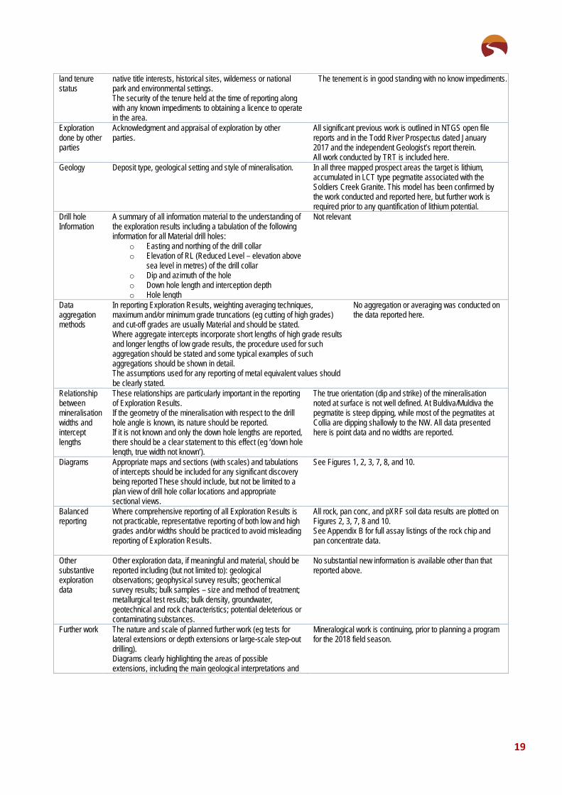
land tenure status
native title interests, historical sites, wilderness or national park and environmental settings. The security of the tenure held at the time of reporting along with any known impediments to obtaining a licence to operate in the area.
The tenement is in good standing with no know impediments.
Exploration done by other parties
Acknowledgment and appraisal of exploration by other parties.
All significant previous work is outlined in NTGS open file reports and in the Todd River Prospectus dated January 2017 and the independent Geologist’s report therein. All work conducted by TRT is included here.
Geology Deposit type, geological setting and style of mineralisation. In all three mapped prospect areas the target is lithium, accumulated in LCT type pegmatite associated with the Soldiers Creek Granite. This model has been confirmed by the work conducted and reported here, but further work is required prior to any quantification of lithium potential.
Drill hole Information
A summary of all information material to the understanding of the exploration results including a tabulation of the following information for all Material drill holes:
o Easting and northing of the drill collar o Elevation of RL (Reduced Level – elevation above
sea level in metres) of the drill collar o Dip and azimuth of the hole o Down hole length and interception depth o Hole length
Not relevant
Data aggregation methods
In reporting Exploration Results, weighting averaging techniques, maximum and/or minimum grade truncations (eg cutting of high grades) and cut-off grades are usually Material and should be stated. Where aggregate intercepts incorporate short lengths of high grade results and longer lengths of low grade results, the procedure used for such aggregation should be stated and some typical examples of such aggregations should be shown in detail. The assumptions used for any reporting of metal equivalent values should be clearly stated.
No aggregation or averaging was conducted on the data reported here.
Relationship between mineralisation widths and intercept lengths
These relationships are particularly important in the reporting of Exploration Results. If the geometry of the mineralisation with respect to the drill hole angle is known, its nature should be reported. If it is not known and only the down hole lengths are reported, there should be a clear statement to this effect (eg ‘down hole length, true width not known’).
The true orientation (dip and strike) of the mineralisation noted at surface is not well defined. At Buldiva/Muldiva the pegmatite is steep dipping, while most of the pegmatites at Collia are dipping shallowly to the NW. All data presented here is point data and no widths are reported.
Diagrams Appropriate maps and sections (with scales) and tabulations of intercepts should be included for any significant discovery being reported These should include, but not be limited to a plan view of drill hole collar locations and appropriate sectional views.
See Figures 1, 2, 3, 7, 8, and 10.
Balanced reporting
Where comprehensive reporting of all Exploration Results is not practicable, representative reporting of both low and high grades and/or widths should be practiced to avoid misleading reporting of Exploration Results.
All rock, pan conc, and pXRF soil data results are plotted on Figures 2, 3, 7, 8 and 10. See Appendix B for full assay listings of the rock chip and pan concentrate data.
Other substantive exploration data
Other exploration data, if meaningful and material, should be reported including (but not limited to): geological observations; geophysical survey results; geochemical survey results; bulk samples – size and method of treatment; metallurgical test results; bulk density, groundwater, geotechnical and rock characteristics; potential deleterious or contaminating substances.
No substantial new information is available other than that reported above.
Further work The nature and scale of planned further work (eg tests for lateral extensions or depth extensions or large-scale step-out drilling). Diagrams clearly highlighting the areas of possible extensions, including the main geological interpretations and
Mineralogical work is continuing, prior to planning a program for the 2018 field season.

20
future drilling areas, provided this information is not commercially sensitive.

21
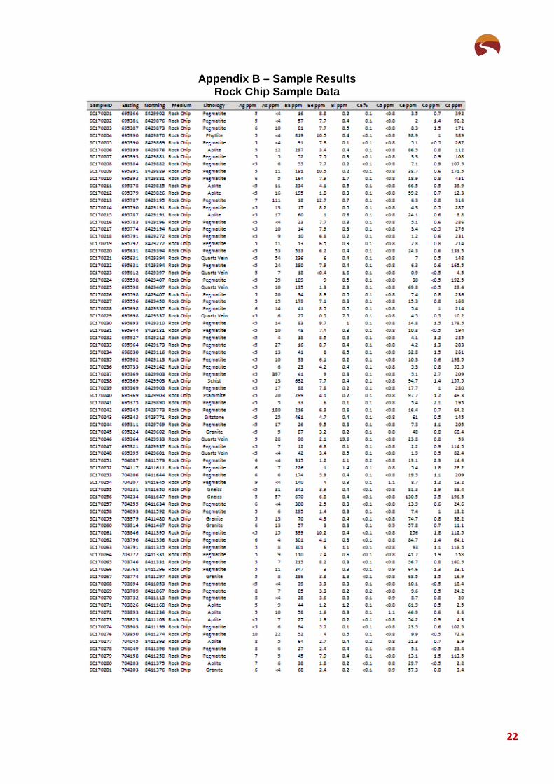
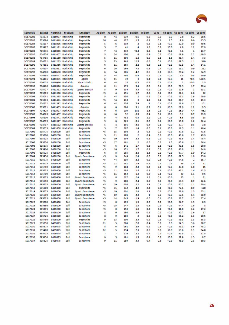
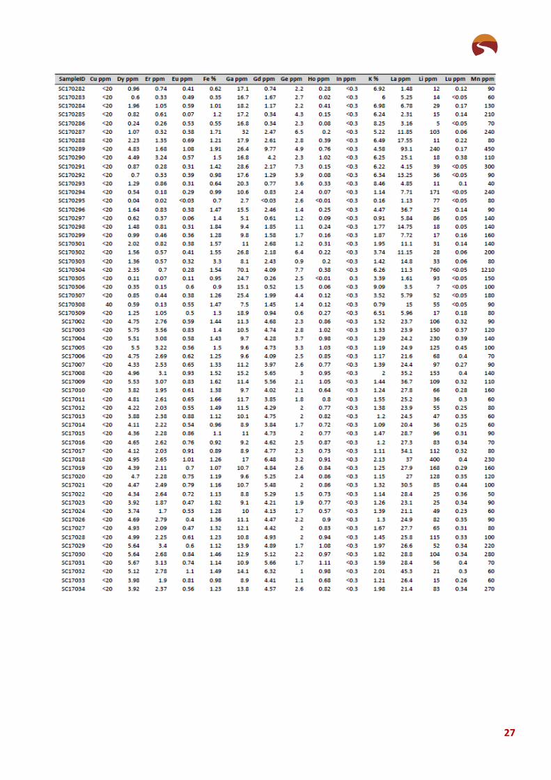
Appendix B – Sample Results Rock Chip and Pan Concentrate Samples
Pan Concentrate Data
Coordinates are MGA94 Zone53
SampleID Prospect Easting Northing SnO2_% Ce_ppm La_ppm Nd_ppm Pr_ppm Sm_ppm
SCA01 Buldiva 695579 8429326 68.56 13.2 6.08 6.44 1.42 1.77SCA02 Buldiva 695602 8429274 0.93 29.2 11.5 13.1 3.2 3.59SCA03 Buldiva 695813 8429328 74.65 13.6 5.52 6.32 1.61 1.62SCA04 Buldiva 695700 8429230 24.69 34.3 15.45 15.3 3.9 5.33SCA05 Buldiva 695671 8429202 35.42 44.3 19.45 19.4 5.6 8.97SCA06 Buldiva 695828 8429315 44.56 29 12.9 12.6 3.43 6.02SCA07 Buldiva 695854 8429309 41.26 33.6 16.35 14.25 3.95 4.51SCA08 Buldiva 695952 8429398 73.00 10.5 5.3 4.48 1.29 1.18SCA09 Muldiva 695512 8430177 0.27 18 8.74 8.14 2.13 1.97SCA10 Collia 704648 8410812 28.44 956 517 356 102 77.7SCA11 Collia 705009 8410951 54.21 1425 680 497 148 115.5SCA12 Collia 704093 8411410 0.57 721 325 294 84.6 59.5SCA13 Collia 703727 8411307 12.51 6420 2990 2480 714 551SCA14 Collia 704076 8411520 15.17 1285 573 518 148 112SCA15 Collia 704369 8411242 33.77 3740 1750 1405 409 307SCA16 Collia 704523 8411156 8.18 7350 3480 2750 789 600SCA17 Collia 704807 8411129 0.29 450 213 174.5 50.9 31.1SCA18 Collia 704666 8411343 0.90 1920 842 718 201 150.5SCA19 Collia 705381 8410865 44.94 3370 1480 1260 369 275SCA20 Collia 704583 8411472 6.47 12200 6070 4870 1385 1135SCA21 Collia 704407 8411703 19.42 8510 3880 3290 944 732SCA22 Collia 703337 8411203 0.17 1595 753 606 168.5 128
22
Appendix B – Sample Results Rock Chip Sample Data

23

24

25
26
27

28

29