Whole crustal response to late Tertiary extension near...
15
For permission to copy, contact [email protected] © 2008 Geological Society of America Whole crustal response to late Tertiary extension near Prince Rupert, British Columbia Lincoln S. Hollister* Department of Geosciences, Princeton University, Princeton, New Jersey 08544, USA John Diebold Lamont Doherty Earth Observatory, P.O. Box 1000, Route 9W, Palisades, New York 10964, USA Triparna Das Department of Geosciences, Princeton University, Princeton, New Jersey 08544, USA 360 Geosphere; April 2008; v. 4; no. 2; p. 360–374; doi: 10.1130/GES000144.1; 10 figures. *Corresponding author: [email protected] ABSTRACT Crust-penetrating multichannel seismic data imaged crustal features of late Tertiary extension in east Dixon Entrance, British Columbia. The data show grabens as much as 3 km deep, mid-crustal west-dipping reflecting packages interpreted as normal sense shear zones, middle to lower crustal subhorizontal reflecting horizons, a generally reflective Moho, and arches of the Moho with relief of as much as 3 km (Moho depths 24.8– 27.5 km). Based on dated extension-related features reported for the region, east-west extension occurred between 40 and 20 Ma and may have been concentrated between 25 and 20 Ma. If the pre–late Tertiary crustal thick- ness of east Dixon Entrance was the same as that of the mainland to the east (34 km), the minimum amount of crustal thinning in the study area was 30%. Thinning of the whole crust above a stronger mantle lithosphere is implied by the extension-related features that we describe from the brittle upper crust down through the ductile lower crust to the Moho. Our data confirm and extend the interpre- tation of crustal extension by Lowe and Dehler and Dehler et al. for Hecate Strait and Queen Charlotte Sound. Integration of our results with the geologic history across the study area leads to a conclusion that preexisting zones of weakness may have controlled the pattern of crustal thinning during the extension. Keywords: crustal extension, seismic reflectivity, Moho, British Columbia, tectonic reactivation. INTRODUCTION The 1994 ACCRETE offshore-onshore wide- angle reflection and refraction seismic experi- ment (http://geoweb.princeton.edu/research/ ACCRETE/accrete.html) imaged features related to the accretion of terranes in western Canada (Morozov et al., 1998, 2001, 2003; Hammer et al., 2000; Hammer and Clowes, 2004; Rohr et al., 2000; Andronicos et al., 2003; Hollister and Andronicos, 2006). Included in the ACCRETE study was the collection of 1700 km of marine multichannel seismic (MCS) reflec- tion data in the inland waterways of northern British Columbia and southeast Alaska (Rohr et al., 2000; Das, 1997; Figs. 1 and 2). Previous geological and geophysical studies concluded that Miocene extension resulted in the opening of Hecate Strait and Queen Char- lotte Sound (Fig. 2). Rohr and Dietrich (1992) used MCS reflection data to image extensional grabens in this region (Fig. 2). Dehler et al. (1997) integrated those seismic reflection data with seismic refraction, geologic, gravity, and heat-flow data (Hyndman and Hamilton, 1993; Lowe and Dehler, 1995; Spence and Asudeh, 1993; Spence and Long, 1995; Hickson, 1991; Woodsworth, 1991) to describe this extension. Intersecting ACCRETE MCS reflection lines in east Dixon Entrance (Fig. 3) provide a crude three-dimensional image of 6000 km 2 of the crust. These profiles are described and inter- preted in this paper. We tie our MCS results to the onshore-offshore wide-angle reflection and refraction results of Morozov et al. (1998, 2001, 2003) and describe the response of the whole crust of east Dixon Entrance to late Tertiary extension. Our results confirm and extend the evidence for Neogene extensional tectonics in Queen Charlotte Sound and Hecate Strait; we describe the effects of the extension on the whole crust, and we infer that the pattern of response of the crust to extension may have been controlled by anisotropy in the crust formed during terrane accretion during the Mesozoic. GEOLOGICAL AND GEOPHYSICAL SETTING Hollister and Andronicos (2006) used the results of ACCRETE and those of previous studies to compile a geologic cross section (Fig. 4) from the interior of British Columbia to the Pacific Ocean. Included in their inter- pretation of this section is the recognition of the profound effects of an early Tertiary high- temperature extension event in forming the crust east of the Coast shear zone. This exten- sion occurred while the rocks east of the shear zone were partially molten, and we assume here that extension of crust when the lower part was partially melted would lead to a rela- tively flat Moho. The map pattern for the Coast Mountains batholith (Fig. 1) outlines the region where the early Tertiary high-temperature extension likely occurred. The Insular superterrane, which is com- posed of the Alexander and Wrangellia ter- ranes, is to the west of the Coast shear zone (Fig. 1). Queen Charlotte Sound, Hecate Strait, and Dixon Entrance are bordered by islands and headlands underlain mainly by the Insular superterrane. The inferred boundary between Wrangellia to the southwest and the Alex- ander terrane to the northeast projects across our study area (Wheeler and McFeely, 1991; Fig. 1). During the mid-Cretaceous, units of the Insular superterrane within the study area
Transcript of Whole crustal response to late Tertiary extension near...

For permission to copy, contact [email protected]© 2008 Geological Society of America
Whole crustal response to late Tertiary extension near Prince Rupert, British Columbia
Lincoln S. Hollister*Department of Geosciences, Princeton University, Princeton, New Jersey 08544, USA
John DieboldLamont Doherty Earth Observatory, P.O. Box 1000, Route 9W, Palisades, New York 10964, USA
Triparna DasDepartment of Geosciences, Princeton University, Princeton, New Jersey 08544, USA
360
Geosphere; April 2008; v. 4; no. 2; p. 360–374; doi: 10.1130/GES000144.1; 10 fi gures.
*Corresponding author: [email protected]
ABSTRACT
Crust-penetrating multichannel seismic data imaged crustal features of late Tertiary extension in east Dixon Entrance, British Columbia. The data show grabens as much as 3 km deep, mid-crustal west-dipping refl ecting packages interpreted as normal sense shear zones, middle to lower crustal subhorizontal refl ecting horizons, a generally refl ective Moho, and arches of the Moho with relief of as much as 3 km (Moho depths 24.8–27.5 km). Based on dated extension-related features reported for the region, east-west extension occurred between 40 and 20 Ma and may have been concentrated between 25 and 20 Ma. If the pre–late Tertiary crustal thick-ness of east Dixon Entrance was the same as that of the mainland to the east (34 km), the minimum amount of crustal thinning in the study area was 30%.
Thinning of the whole crust above a stronger mantle lithosphere is implied by the extension-related features that we describe from the brittle upper crust down through the ductile lower crust to the Moho. Our data confi rm and extend the interpre-tation of crustal extension by Lowe and Dehler and Dehler et al. for Hecate Strait and Queen Charlotte Sound. Integration of our results with the geologic history across the study area leads to a conclusion that preexisting zones of weakness may have controlled the pattern of crustal thinning during the extension.
Keywords: crustal extension, seismic refl ectivity, Moho, British Columbia, tectonic reactivation.
INTRODUCTION
The 1994 ACCRETE offshore-onshore wide-angle refl ection and refraction seismic experi-ment (http://geoweb.princeton.edu/research/ACCRETE/accrete.html) imaged features related to the accretion of terranes in western Canada (Morozov et al., 1998, 2001, 2003; Hammer et al., 2000; Hammer and Clowes, 2004; Rohr et al., 2000; Andronicos et al., 2003; Hollister and Andronicos, 2006). Included in the ACCRETE study was the collection of 1700 km of marine multichannel seismic (MCS) refl ec-tion data in the inland waterways of northern British Columbia and southeast Alaska (Rohr et al., 2000; Das, 1997; Figs. 1 and 2).
Previous geological and geophysical studies concluded that Miocene extension resulted in the opening of Hecate Strait and Queen Char-lotte Sound (Fig. 2). Rohr and Dietrich (1992) used MCS refl ection data to image extensional grabens in this region (Fig. 2). Dehler et al. (1997) integrated those seismic refl ection data with seismic refraction, geologic, gravity, and heat-fl ow data (Hyndman and Hamilton, 1993; Lowe and Dehler, 1995; Spence and Asudeh, 1993; Spence and Long, 1995; Hickson, 1991; Woodsworth, 1991) to describe this extension.
Intersecting ACCRETE MCS refl ection lines in east Dixon Entrance (Fig. 3) provide a crude three-dimensional image of 6000 km2 of the crust. These profi les are described and inter-preted in this paper. We tie our MCS results to the onshore-offshore wide-angle refl ection and refraction results of Morozov et al. (1998, 2001, 2003) and describe the response of the whole crust of east Dixon Entrance to late Tertiary extension. Our results confi rm and extend the evidence for Neogene extensional tectonics in
Queen Charlotte Sound and Hecate Strait; we describe the effects of the extension on the whole crust, and we infer that the pattern of response of the crust to extension may have been controlled by anisotropy in the crust formed during terrane accretion during the Mesozoic.
GEOLOGICAL AND GEOPHYSICAL SETTING
Hollister and Andronicos (2006) used the results of ACCRETE and those of previous studies to compile a geologic cross section (Fig. 4) from the interior of British Columbia to the Pacifi c Ocean. Included in their inter-pretation of this section is the recognition of the profound effects of an early Tertiary high- temperature extension event in forming the crust east of the Coast shear zone. This exten-sion occurred while the rocks east of the shear zone were partially molten, and we assume here that extension of crust when the lower part was partially melted would lead to a rela-tively fl at Moho. The map pattern for the Coast Mountains batholith (Fig. 1) outlines the region where the early Tertiary high- temperature extension likely occurred.
The Insular superterrane, which is com-posed of the Alexander and Wrangellia ter-ranes, is to the west of the Coast shear zone (Fig. 1). Queen Charlotte Sound, Hecate Strait, and Dixon Entrance are bordered by islands and headlands underlain mainly by the Insular superterrane. The inferred boundary between Wrangellia to the southwest and the Alex-ander terrane to the northeast projects across our study area (Wheeler and McFeely, 1991; Fig. 1). During the mid-Cretaceous, units of the Insular superterrane within the study area

Late Tertiary extension, B.C.
Geosphere, April 2008 361
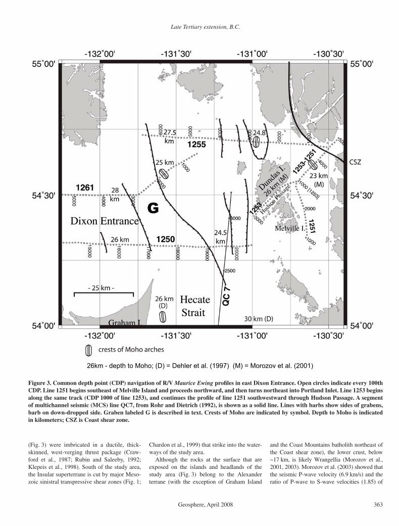
Figure 1. Regional map showing distribution of major geologic features of southeast Alaska and the north coast of British Columbia, and the location of the boundary between Wrangellia (southwest side) and the Alexander terrane (northeast side), after Wheeler and McFeeley (1991). Also shown south of Prince Rupert are three Mesozoic sinistral shear zones (Chardon et al., 1999) that project into the study area of east Dixon Entrance (see Fig. 3). SW-NE—line of the geologic cross section shown in Figure 4.

Hollister et al.
362 Geosphere, April 2008
º º
º
ºº
º
º º º
º
º
Figure 2. ACCRETE ship tracks (solid lines) and on-shore portable seismometer locations (small open circles). Numbers on ship tracks identify multichannel seismic (MCS) profi les. Shows area of Figure 3, the study area, grabens related to late Tertiary crustal extension (after Rohr and Currie, 1997), including those identifi ed in this study, and late Tertiary sediment basins and extrusive volcanic rocks. Localities A and B are discussed in text. G labels a large graben described in text.
Late Tertiary extension, B.C.
Geosphere, April 2008 363
(Fig. 3) were imbricated in a ductile, thick-skinned, west-verging thrust package (Craw-ford et al., 1987; Rubin and Saleeby, 1992; Klepeis et al., 1998). South of the study area, the Insular superterrane is cut by major Meso-zoic sinistral transpressive shear zones (Fig. 1;
Chardon et al., 1999) that strike into the water-ways of the study area.
Although the rocks at the surface that are exposed on the islands and headlands of the study area (Fig. 3) belong to the Alexander terrane (with the exception of Graham Island
and the Coast Mountains batholith northeast of the Coast shear zone), the lower crust, below ~17 km, is likely Wrangellia (Morozov et al., 2001, 2003). Morozov et al. (2003) showed that the seismic P-wave velocity (6.9 km/s) and the ratio of P-wave to S-wave velocities (1.85) of
26km - depth to Moho; (D) = Dehler et al. (1997) (M) = Morozov et al. (2001)
Figure 3. Common depth point (CDP) navigation of R/V Maurice Ewing profi les in east Dixon Entrance. Open circles indicate every 100th CDP. Line 1251 begins southeast of Melville Island and proceeds northward, and then turns northeast into Portland Inlet. Line 1253 begins along the same track (CDP 1000 of line 1253), and continues the profi le of line 1251 southwestward through Hudson Passage. A segment of multichannel seismic (MCS) line QC7, from Rohr and Dietrich (1992), is shown as a solid line. Lines with barbs show sides of grabens, barb on down-dropped side. Graben labeled G is described in text. Crests of Moho are indicated by symbol. Depth to Moho is indicated in kilometers; CSZ is Coast shear zone.

Hollister et al.
364 Geosphere, April 2008
the lower crust between common depth points (CDPs) 19,000 and 20,000 on line 1250 (Fig. 3) correspond to gabbro. According to Lassiter et al. (1995), Wrangellia, which underlies most of the Queen Charlotte Islands, is a fl ood basalt province composed of basalt from a plume source that intruded into and through an island arc. The physical properties of the lower crust in the study area are thus consistent with intrusions associated with oceanic fl ood basalt and/or the middle crust of an island arc (Shillington et al., 2004). However, the seismic velocities of the upper crust of the study area are consistent with the felsic crust of the Alexander terrane (Moro-zov et al., 2001, 2003). This felsic portion of the crust thickens toward the east and reaches the Moho at the Coast shear zone (Fig. 4).
Dehler et al. (1997) described extension in Hecate Strait and Queen Charlotte Sound. They inferred that the extension occurred between 43 and 20 Ma based on the age range of late Ter-tiary basalts, which they attributed to decom-pression melting in the mantle due to unloading during the extension. These basalts are com-mon in Queen Charlotte Sound and along its shores (Fig. 2; Hickson, 1991; Woodsworth, 1991; Hyndman and Hamilton, 1993; Rohr and Currie, 1997). The majority of these extension-related basalts extruded between 25 and 20 Ma, which led Dehler et al. (1997) to suggest that the extension may have been focused in this time interval.
Stock and Molnar (1988) and Rohr and Die-trich (1992) concluded that the area inboard of the Queen Charlotte fault underwent a period of transtension during the late Tertiary. Rohr and Dietrich (1992) argued that extension in Queen
Charlotte Sound and Hecate Strait was linked to transform motion along the Queen Charlotte fault, whereby the shear stresses along the fault were distributed across the continental margin as east-west extension and north-northwest dextral strike slip parallel to the Queen Charlotte fault.
The orientations, kinematics, and ages of brittle faults on land, to the east of east Dixon Entrance, help constrain the stretching direc-tion of the late Tertiary extension. According to Evenchick et al. (1999) and van der Heyden et al. (2000), an extensional structure parallels and includes the north-south trend of Portland Canal (Fig. 2), which probably formed by glacial ero-sion along a brittle fault system (Evenchick et al., 1999) associated with this structure. This faulting must have occurred after the rocks of the Coast Mountains batholith, now exposed at the surface, had cooled through the brittle-ductile transition, which took place ca. 48 Ma, according to Hollister (1982) and Andronicos et al. (2003).
At locality A (Fig. 2), north-south– trending nearly vertical faults are on strike with the north-south trend of Portland Canal, and they cut the ductile fabric of the gneiss of the Coast Moun-tains batholith. These faults have slickenslided surfaces and striations indicating east side down displacement and east-west extension. The faults are cut by vertical, northeast-trending basalt dikes that have been assigned ages from 45 to 20 Ma (Gareau et al., 1997; van der Heyden et al., 2000; Evenchick et al., 1999). At locality B (Fig. 2), psuedotachylites, which form during rock displacement that is rapid enough to cause local melting, occur in a dextral strike-slip fault zone within the Coast shear zone, which strikes
parallel to its north-northwest trend; Davidson et al. (2003) dated them as 29.8 Ma, using the Ar/Ar method. The age, orientation, and displace-ment direction of the faults at localities A and B provide a complimentary data set to the pro-posed regional late Tertiary extension described and discussed in this paper.
DATA ACQUISITION AND PROCESSING
The ACCRETE EW9412 seismic profi les together compose a transect from the Pacifi c plate, across the Queen Charlotte fault zone (Rohr et al., 2000), the Wrangellia and Alexan-der terranes, the Coast shear zone, and north-eastward up Portland Inlet and Portland Canal to Stewart, British Columbia (Fig. 2). The inter-pretations in this paper are based on the loose grid of MCS profi les shot in relatively shallow water of east Dixon Entrance (Fig. 3). The air-gun pulses were also recorded by an onshore seismograph array deployed from Dundas Island to Stewart and in line with Portland Canal north of Stewart (Fig. 2) (Morozov et al., 1998, 2001, 2003; Hammer et al., 2000; Hammer and Clowes, 2004).
The seismic source was an 8500 in3 20 airgun array, which was towed by R/V Maurice Ewing, as was a 240 channel, 3000 m digital hydro-phone streamer. This equipment was deployed in the deep water west of the Queen Charlotte fault zone (Fig. 2), and profi ling proceeded eastward. Because of the need to tow and maneuver the hydrophone array all the way into the freshwa-ter at the head of Portland Canal, the array was shortened from its usual 4000 m to 3000, and it
Figure 4. Generalized and simplifi ed southwest-northeast cross section from the Pacifi c plate to the interior of British Columbia from Hol-lister and Andronicos (2006); the location of cross section is shown in Figure 1. Present-day lithologies, location of Moho, compressional wave velocities (Vp, km/s), major geologic features, and displacement directions across major shear and fault zones are shown. Note three arches of the Moho between the Queen Charlotte fault and the Coast shear zone (CSZ). The western arch was defi ned by gravity and wide-angle seismic refl ection (Dehler et al., 1997); the central arch is based on that of line 1255 (Fig. 6); the arch west of the CSZ was defi ned by wide-angle refl ection (Morozov et al., 2001). The portion of section labeled Wrangellia may include the Alexander terrane toward its northeastern limit. CMB—Coast Mountains batholith.

Late Tertiary extension, B.C.
Geosphere, April 2008 365
was reballasted, to match the lower density of freshwater. From the Queen Charlotte fault zone to Melville Island (line 1250, Figs. 2 and 3), it was diffi cult to control the depth of the hydro-phone array, and it tended to tow close to or at the sea surface, resulting in noisy and weak data quality. The array performed as desired within Portland Canal (line 1251). Upon re entering Dixon Entrance, the array was reballasted again, to a density more suitable for seawater. As a result, the refl ection lines 1253, 1255, and 1261, collected subsequent to line 1251, are of higher quality than line 1250.
The diffi culties of acquiring refl ection seismic data in fjords and fjord-like environments are well known (cf. Hurich, 1996; Hurich and Rob-erts, 1997; Brady et al., 2000). Echoes from the rocky walls of these channels are nearly impos-sible to discriminate from the desired vertically traveling arrivals, and reverberations from hard bottoms in a shallow water column are common. Virtually all of our recorded data were domi-nated by waterborne diffracted energy. Similar effects were also described by Hurich (1991). Data processing began, therefore, with the elimination of noisy traces and two-dimensional (F-K) velocity fi ltering of shot gathers, which eliminated much of the waterborne energy arising from diffractions from the bottom and sides of the various waterways. This fi ltering, however, is ineffective at small source-receiver offsets, where the primary refl ections and the water-column multiples are indistinguishable, and in the upper section, where data with larger source-receiver offsets cannot be included in the stacks. The shot gathers were then sorted into CDP gathers spaced 12.5 m apart. Poststack pro-cessing included a further velocity fi ltering pass and deconvolution. Coherence was enhanced by dip-adaptive trace mixing, as well as the usual enhancements afforded by bandpass fi ltering and trace gain adjustments. The result of this processing was that the effects of waterborne diffractions were confi ned to the upper 1–2 s of the profi les in most cases, revealing mid-crustal refl ectors in many locations. Refl ection Moho can also be tracked in most of the profi les.
Self-consistent prestack statics corrections were applied before CDP gathering, and these tended to increase the coherence of crustal refl ections at the expense of the reverberation noise. These were based on a model of the sea-fl oor and of the crystalline basement-sediment interface that was derived from preliminary brute stacks of the data (Das, 1997). Although routinely done in onshore refl ection processing, this was an unusual step for processing marine refl ection data.
The uppermost sedimentary sections are well imaged in simple, non-statics-corrected
stacks (e.g., Fig. 5), whereas the uppermost crustal structures are poorly resolved, due to reverberations and the scattering effects of the rough sediment-basement interface. When the scattering effects are ameliorated by prestack statics corrections, the sedimentary sections are distorted, because the traces were shifted by the computed statics time corrections prior to stack-ing. This procedure improved the coherence of the refl ectors at depth (e.g., Fig. 6) at the cost of the loss of the continuity of the seafl oor refl ec-tions and the refl ections within the top few hun-dred milliseconds of the surface.
Poststack time migration was carried out on most of the stacked sections, but this process tended to smear seismic noise arising from the various sources described above, making the images more diffi cult to interpret. Accord-ingly, we used the technique known as line migration. We digitized the profi le interpre-tations on the prestack static corrected sec-tions, using the stacking velocity functions, and migrated the digitized refl ectors (e.g., Fig. 7) to move them into their original physi-cal positions. This process assumes that all of the refl ections come from within the plane of the seismic profi le. None of the digitized refl ectors was moved far enough by this pro-cess to affect our interpretations. In order to estimate depth of the digitized horizons, the velocity function determined by Morozov et al. (1998, 2001) was used in a similar proce-dure. The easternmost velocity function pre-sented by Morozov et al. (2001, their Fig. 6) was specifi ed for the zone between 20 km and 40 km east-southeast from the southeastern tip of Dundas Island. This corresponds roughly to CDPs 19,200–20,000 of line 1250 (Figs. 3 and 5). Since this is the only place that the Morozov et al. (2001) model overlaps with the area studied in the current paper, it was applied, after combination with the water and sediment column models determined from the MCS data. In this way, the distorting effects of variations in the upper section (such as gra-bens) were minimized.
SEISMIC REFLECTION OBSERVATIONS
In the sections below, we refer to the profi les that best illustrate the features discussed.
Refl ection Moho
In line 1255 (Fig. 6), the Moho refl ection is prominent at 8–9 s two-way traveltime (TWTT) and is in the shape of an arch with ~1 s ampli-tude; the apex of the arch is at approximately CDP 2800. The Moho refl ection is also promi-
nent along line 1253 (Fig. 8). Morozov et al. (2001) reported a depth to the Moho of 26 km at about CDP 2600, where the MCS image of the Moho is at 8.5 s TWTT. Given that the lower crust of the Insular superterrane has a velocity of 6.8 km/s (Morozov et al., 2001), the arch of line 1255 (Fig. 6) has an amplitude of ~3 km, from 24.8 to 27.5 km. Although the character of Moho refl ections is variable, the position and shape of the Moho are clear.
There are several intervals of laterally con-tinuous, high-amplitude refl ectivity that defi ne the Moho, and one interval of especially high amplitude refl ectivity around CDP 5000 (unmigrated). This interval is highly reverber-ant, suggesting the presence of layering with high-velocity contrasts. The fact that similar reverberation is not apparent in the overlying crustal, seafl oor, or sediment refl ections indi-cates that its origin is local to the refl ection Moho. Besides the interval of relatively high refl ectivity on Moho of line 1255, there are also intervals of relatively high amplitude refl ectiv-ity on line 1261 at CDP 1600 (Fig. 7) and on line 1250 at CDP 19,000 (Fig. 5).
Moho on line 1261 (Fig. 7) appears also to have an arch; its apex is at CDP 1700, at a depth of 25 km. Moho deepens to the west from this arch to a keel at a depth of 28 km at CDP 3500.
Middle to Lower Crustal Refl ectivity
Mid to lower crustal discontinuous, subhori-zontal (in line of section) refl ectors (> 5 s TWTT, or ~15 km) are prominent in the profi les shown in Figures 8 and 9. Apparent west-dipping pack-ages of refl ectivity are present in Figures 5, 6, and 8. On the profi le of line 1255 (Fig. 6), one prominent group of refl ectors (CDPs 3600–5400) has apparent dips to the west in the line of section. A second, less prominent, west- dipping group is between CDPs 1000 and 2000. These west-dipping refl ecting packages extend from ~3 s TWTT (~9 km in depth) to almost 6 s TWTT (~18 km in depth). Based on the velocity model of Morozov et al. (2001) the maximum apparent dip of these refl ectors is ~15º.
Because of the crude three-dimensional coverage in the study area, we can constrain the three-dimensional orientation of some of the refl ecting horizons. Portions of lines 1251 and 1253 (Figs. 1 and 3) are merged into one continuous line (Fig. 8) from the Coast shear zone through Hudson Passage, in line with Portland Inlet (Fig. 2). In Figure 8, CDPs are shown for line 1251 from 5000 to 3000 (north-east half of fi gure) and for line 1253 from 1000 to 3000 (southwest half of fi gure). The portion of the seismic section through Hudson Passage (Fig. 3) shows a southwest-dipping (in line
Hollister et al.
366 Geosphere, April 2008
14,500 15,500 16,500 17,500 18,500 19,500 20,500
15,000 16,000 17,000 18,000 19,000 20,000
12
11
10
9
8
7
6
5
4
3
2
1
0
12
11
10
9
8
7
6
5
4
3
2
1
0
<- West East ->
EW9412 Line 1250
14,000
Moho
Bright Moho
West-dipping reflectors
14,500 15,500 16,500 17,500 18,500 19,500 20,500
15,000 16,000 17,000 18,000 19,000 20,000
12
11
10
9
8
7
6
5
4
3
2
1
0
12
11
10
9
8
7
6
5
4
3
2
1
0
Tw
o-w
ay tr
avel
time,
s
25 km
<- West East ->
EW9412 Line 1250
14,000
Tw
o-w
ay tr
avel
time,
sT
wo-
way
trav
eltim
e, s
Tw
o-w
ay tr
avel
time,
s
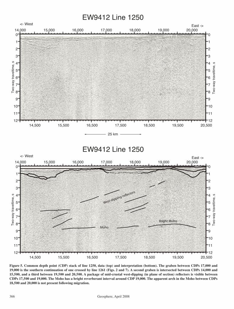
Figure 5. Common depth point (CDP) stack of line 1250, data (top) and interpretation (bottom). The graben between CDPs 17,000 and 19,000 is the southern continuation of one crossed by line 1261 (Figs. 2 and 7). A second graben is intersected between CDPs 14,000 and 15,500, and a third between 19,500 and 20,500. A package of mid-crustal west-dipping (in plane of section) refl ectors is visible between CDPs 17,500 and 19,000. The Moho has a bright reverberant interval around CDP 19,000. The apparent arch in the Moho between CDPs 18,500 and 20,000 is not present following migration.

Late Tertiary extension, B.C.
Geosphere, April 2008 367
6000 5000 4000 3000 2000 1000
6000 5000 4000 3000 2000 1000
EW9412 Line 1255 CDP#
12
11
10
9
8
7
6
5
4
3
2
1
0
12
11
10
9
8
7
6
5
4
3
2
1
0T
wo-
way
trav
eltim
e, s
25 kmA
6000 5000 4000 3000 2000 1000
6000 5000 4000 3000 2000 1000
EW9412 Line 1255 CDP #
12
11
10
9
8
7
6
5
4
3
2
1
0
12
11
10
9
8
7
6
5
4
3
2
1
0
Tw
o-w
ay tr
avel
time,
s
25 km
East Dixon Entrance
SW-dipping reflectors
East-dipping reflectors
Moho archbright spot
mid-crustal reflectors
grabengrabengraben
B
Figure 6. (A) Seismic profi le for line 1255. Prestack statics corrections have been applied to enhance the coherence of crustal refl ectors (Das, 1997). Those include strong, west-dipping mid-crustal refl ection packages between common depth points (CDP) 3600 and 5400, and between CDPs 1000 and 2000. The strongest mid-crustal refl ector, at ~4 s two-way traveltime (TWTT), between CDPs 3800 and 5400, dips westward at ~15°. East-dipping refl ectors occur at 3–4 s TWTT between CDP 600–1200. The refl ection Moho defi nes a smooth arch, with a very bright reverberant section around CDP 5000. Subhorizontal lower crustal refl ectors are apparent below 5 s TWTT. The absence of refl ecting packages, for example between CDPs 2000 and 2500, is likely due to interference from shallow structures (Peddy and Hobbes, 1987). (B) Line drawing interpretations of refl ecting horizons of A. (Continued on following page.)

Hollister et al.
368 Geosphere, April 2008
12
11
10
9
8
7
6
5
4
3
2
1
0
two-
way
trav
eltim
e, s
6000 5000 4000 3000 2000 1000
unmigratedmigrated
EW9412 Line 1255 CDP #
East Dixon Entrance
C
30
25
20
15
10
5
0
dept
h, k
m
6000 5000 4000 3000 2000 1000
V. E. 1.0
EW9412 Line 1255 CDP #
East Dixon Entrance
D
Figure 6 (continued). (C) Line drawings of the crustal arrivals in B (shown in black) have been migrated, using the velocity function of Morozov et al. (2001), and shown in red. Each individual line segment in the digitized horizons is migrated separately, and their positions may diverge, as dipping arrivals migrate updip in proportion to their observed dips. (D) The migrated line segments of C are converted to depth, again using the Morozov et al. (2001) velocity function. Despite the distorting effect of the two grabens labeled in B, the Moho arch is retained.

Late Tertiary extension, B.C.
Geosphere, April 2008 369
5000 4000 3000 2000 1000
12
11
10
9
8
7
6
5
4
3
2
1
0
Tw
o-w
ay tr
avel
time,
s
12
11
10
9
8
7
6
5
4
3
2
1
0
Tw
o-w
ay tr
avel
time,
s
<- West East -> <- Southwest Northeast ->(course change)
EW9412 Line 1261 data
12
11
10
9
8
7
6
5
4
3
2
1
0
Tw
o-w
ay tr
avel
time,
s
12
11
10
9
8
7
6
5
4
3
2
1
0
Tw
o-w
ay tr
avel
time,
s
EW9412 Line 1261 horizons, reflectors from image and velocity analysis
30
25
20
15
10
5
0
dept
h, k
m
5000 4000 3000 2000 1000
V. E. 1.0
EW9412 Line 1261, line migrated with Morozov velocity function
G
Figure 7. Line 1261. Top panel: pro-cessed data. As shown in Figure 3, this profi le includes a course change as it passes over a sizeable graben (G), located between common depth points (CDPs) 1800 and 3500. Due to strong reverbera-tions over thinly sedimented sections and weather-induced shallow towing of the hydrophone array, data quality is poor. Nonetheless, the Moho is detectable from place to place, particularly beneath the graben, where reverberations are minimized. Middle panel: line draw-ing interpretation of refl ecting horizons of line 1261. Depth to the graben fl oor is constrained by analysis of refracted and wide-angle refl ected arrivals in shot gathers. Lower panel: line segments of the horizons picked in middle panel have been migrated, using the velocity function of Morozov et al. (2001). In the lower panel, the migrated arrivals are plotted at the same horizontal scale as in the other panels, but the vertical scale is in kilometers, with no vertical exaggera-tion. The graben is thus determined to have a depth of 2.75 km, and the Moho depth varies from 25 to 28 km. This pro-cess was used to determine Moho depths for all the EW9412 profi les presented in this paper.

Hollister et al.
370 Geosphere, April 2008
of section) refl ector (Fig. 8) from a depth of 3 s TWTT down into a zone of horizontal (in line of section) mid-crustal refl ectors at ~6 s TWTT (about CDP 2200 on line 1253). How-ever, where line 1251 trends nearly north along the east side of Melville Island (south of CDP 3000; Fig. 9), there are no dipping refl ectors; where the line turns to a northeast trend there is a southwest-dipping refl ector. In Figure 8, this same refl ector merges with the southwest- dipping refl ector on line 1253. The portion of line 1253 (not shown) that trends north, along the west side of Dundas Island (Fig. 2), also has apparent subhorizontal lower crustal refl ectiv-ity, which is similar to that illustrated on the north-trending portion of the profi le shown in Figure 9 (CDPs 1000–3000). Because the nearly north-south segments of lines 1253 and 1251 do not show dipping refl ectors, and because the east-west lines (Figs. 5 and 6) and northeast–southwest lines (Fig. 8) do show dipping refl ectors, the resolved dip of the refl ectors is toward the west, with a strike line nearly north-south.
East-dipping refl ecting horizons occur between 3 and 4 s TWTT at the eastern end of
line 1255 (Fig. 6), near CDP 600–1200. A fab-ric with this orientation was also imaged by the wide-angle seismic refl ection experiment of Morozov et al. (2001).
Grabens
Grabens were clearly imaged in the stan-dard CDP stacks of lines 1255 (Fig. 6), 1250 (Fig. 5) and 1261 (Fig. 7). Simple non statics-corrected stacks enhance shallow sedimen-tary sections and this was done for profi les 1250 and 1261. Three grabens are shown in Figure 5. The graben on line 1261 (Fig. 7), between CDPs 1800 and 3400, has ~3 km of sediment fi ll based on its depth in TWTT of2 s. For line 1250 (Fig. 5), the graben between CDPs 17,000 and 19,000 likely connects with the one imaged on line 1261 to the north-west and one imaged to the southeast on QC7 (CDPs 2400–2000; Rohr and Dietrich, 1992). These are connected in Figure 2 and labeled G. The eastern side of the same graben is imaged on line 1255 at CDP 6400, but this is not clear in Figure 6 because this profi le was not pro-cessed to image shallow features.
DISCUSSION OF FEATURES ATTRIBUTED TO LATE TERTIARY EXTENSION
Figure 10 shows a compilation of our imaged features on an idealized east-west profi le. The fi gure shows the arch in the Moho that is clearly imaged on line 1255. The Moho is refl ective, and an interval below the Moho of high- amplitude refl ectivity is also shown (bright spot). Packages of west-dipping refl ectors occur in the middle crust, and the lower crust has refl ectors subpar-allel to Moho, especially toward the eastern por-tion of the profi le.
The relatively high refl ectivity of the Moho may be due to shearing at the mantle-crust boundary during extension. In observations of other extended terranes, extension Moho typically appears as a narrow band of gen-erally continuous refl ections. Hammer and Clowes (1997), in reviewing occurrences of Moho refl ections in the Canadian Lithoprobe transects, found that the strong, coherent Moho refl ections appeared to be in zones where whole crustal deformation has been recognized, including crustal extension. Strain localized
EW9412 EW9412
two
-way
tra
velt
ime,
s
two
-way
tra
velt
ime,
s
Figure 8. Common depth point (CDP) stack of line 1251–1253. Two line segments are juxtaposed, showing the continuity of the southwest-dipping (in line of section) mid-crustal refl ector beneath Dundas and Melville Islands. Middle and lower crustal subhorizontal refl ections are prominent at depths >5 s two-way traveltime (TWTT); the Moho is well imaged.

Late Tertiary extension, B.C.
Geosphere, April 2008 371
at the crust-Moho discontinuity could result in sharpening the velocity gradient, and shear-ing within the transitional zone would enhance refl ective properties.
One interpretation of the high-amplitude refl ective intervals on the Moho is that they could be due to where basalt accumulated below the crust-mantle interface after rising through the mantle lithosphere. The occurrences of late Tertiary volcanism (Fig. 2), which Rohr and Currie (1997) and Dehler et al. (1997) argued result from decompression melting during the late Tertiary extension of the region, support the inference that the high-amplitude refl ec-tive intervals could represent accumulations of solidifi ed basalt within upper mantle peridotite.
We interpret the west-dipping refl ecting hori-zons to be ductile normal sense shear zones produced during east-west extension. There are no west-dipping structures on the islands and headlands that surround and lie within the study area. In contrast, the prevailing dip of the
mid-Cretaceous rock fabric on shore is toward the northeast or east (Hutchison, 1982; Klepeis et al., 1998; Gehrels, 2001). If the west-dipping mid-crustal fabric (Fig. 10) is due to ductile shearing, the fact that it is not observed at the surface implies it is relatively young; i.e., there has not been enough exhumation to bring rocks to the surface that were below the brittle-ductile transition during the late Tertiary.
Dipping horizons that are oriented parallel to the extension direction were described by Peddy and Hobbes (1987) for offshore south-west Britain. These are in the same depth range as those we imaged. Lie and Husebye (1994) also described refl ectors along the northwest side of the Permian Skagerrack graben of Scan-dinavia with apparent dips in the direction of extension. Lie and Husebye (1994) interpreted these to be a reactivated preextension fabric. An arch is imaged beneath the southern segment of the Skagerrack graben (Lie and Husebye, 1994), and it is under dipping refl ectors, simi-
lar to the relation shown in Figure 10. We sug-gest that the ACCRETE-imaged west-dipping refl ectors are normal sense shear zones that helped transfer strain from the brittle region of the crust, where the grabens occur, down into the region of ductile fl ow (below ~5 s TWTT).
Refl ection seismic profi les over extended continental crust typically show a refl ective zone in the lower crust, as seen in Figures 8 and 9, extending to the Moho (e.g., Allmendinger et al., 1987; Peddy and Hobbs, 1987; Holbrook, 1990; Holbrook et al., 1991). In the northern Basin and Range province these features have been attributed to combinations of ductile fl ow in felsic crust and basalt sills intruded during extension (Holbrook et al., 1991). Adams et al. (1997) attributed subhorizontal crustal refl ec-tivity to layering in mafi c intrusions, based on correlation of seismic data with lithologies found in a drill core. In the study by Adams et al. (1997), the average seismic velocities are similar to those found by Morozov et al. (2003)
1000 1500 2000 2500 3000 3500 4000
1000 1500 2000 2500 3000 3500 4000
12
11
10
9
8
7
6
5
4
3
2
1
0
Tw
o-w
ay tr
avel
time,
s
12
11
10
9
8
7
6
5
4
3
2
1
0
Tw
o-w
ay tr
avel
time,
s
25 km
<- SSE NNW -> <- SW NE ->
EW9412 Line 1251
East of Melville Island
Figure 9. Portion of line 1251 extending parallel to eastern shore of Melville Island from common depth point (CDP) 1000–2900; at CDP 2900, the track turns northeast, beginning the southwest-northeast crossing of the Coast shear zone into Portland Inlet. Subhorizontal middle and lower crustal refl ections are plentiful below 4.8 s two-way traveltime (TWTT). The mid-crustal southwest-dipping (in line of section) refl ectors occur only between CDPs 2900 and 4000, where the line is northeast-southwest. The refl ections are subhorizontal where the line trends north-south, between CDPs 1000 and 2900, showing that the true dip of the refl ectors is to the west.

Hollister et al.
372 Geosphere, April 2008
in the lower crust of the Insular superterrane, that correspond to gabbro. Thus, some of the lower crustal refl ectivity in our study area could be due to layering in gabbro intrusions accen-tuated by shear strain. However, lower crustal refl ectivity is most prominent in the eastern por-tion of our study area, where the seismic data of Morozov et al. (2001) indicate most of the crust is felsic (Fig. 4, for the mid-Cretaceous thrust belt at and southeast of the Coast shear zone), and therefore more likely to show features attributable to ductile fl ow of felsic rock.
The wide-angle refl ection-refraction experi-ment (Morozov et al., 1998, 2001) imaged a pronounced arch in the Moho immediately west of the Coast shear zone (Figs. 3 and 4). The apex of this Moho arch is at a depth of 23 km. The depth to Moho increases to 26 km toward the southwest limit of the wide-angle model (CDP 2700 on line 1253; Fig. 8). The dip of the west side of this arch is continuous with the east-dipping wide-angle refl ecting horizons (<3 s TWTT; Fig. 4) that Morozov et al. (2001) interpreted to be a mid-Cretaceous thrust fabric. This fabric, which is also seen at the eastern end of line 1255 (Fig. 6), may have
controlled the location of shear at this location during the late Tertiary extension.
The location and orientation of the large northwest-trending graben (G in Figs. 2, 3, and 10) suggest that its orientation may have been controlled by a preexisting weakness in the crust created by one or more of the Mesozoic sinistral shear zones and/or the Wrangellia-Alexander terrane boundary that project into it (Fig. 1; Chardon et al., 1999). The shear zones and the graben are subparallel to the Coast shear zone and the late Miocene dextral shears within the Coast shear zone (location B; Fig. 2). The age and kinematics of the late Miocene dextral shears are compatible with late Tertiary east-west extension. Chardon et al. (1999, p. 284) described late dextral shearing where the north-east side of the graben comes onshore south of the study area, and suggested that this displace-ment represents partitioning of slip during the Miocene transtension. Morozov et al. (2001) interpreted an apparent offset across the west side of the graben, within the study area, of an off-line wide-angle refl ector to be due to dextral shear during transtension. Dextral offset across the graben is schematically noted in Figure 10.
Lowe and Dehler (1995) used gravity to model crustal thickness from Hecate Strait south through Queen Charlotte Sound. The model is constrained by seismic refraction data from that region (Spence and Asudeh, 1993). They described an arch in the Moho in northern Hec-ate Strait with depth to the Moho of 26 km; it is located (Fig. 3) at ~131.7º–131.5°W and 54°N, and deepens eastward to 30 km at the limit of their model at 131°W and 54°N (Fig. 3).
East of the Coast shear zone, the thickness under the Coast Mountains batholith, prior to the late Tertiary extension was 34 km. This is based on an average of 2 km height of the mountains added to the deepest present-day Moho under the Coast Mountains batholith of 32 km below sea level (Morozov et al., 2001). The Coast Mountains east of the Coast shear zone were affected by a profound episode of early Tertiary extension while the rocks there were partially melted (Andronicos et al., 2003). Accordingly, it is reasonable to assume that Moho was rela-tively fl at and 34 km deep following this event. Assuming no discontinuity across the Coast shear zone prior to the late Tertiary extension, a preextension depth to Moho across the Coast
Figure 10. Interpretative sketch of east-west seismic profi les, based mainly on data from line 1255 (Fig. 6), showing the refl ective Moho, arch of Moho, bright reverberant interval (bright spot) on Moho, grabens, packages of west-dipping refl ecting horizons interpreted as nor-mal sense shear zones, and middle to lower crustal subhorizontal refl ectivity. Northwest-trending dextral component of offset is shown on the western side of the western graben. These features are consistent with an interpretation of extension of the whole crust in an east-west direction. In addition, east-dipping refl ectors at the eastern end of section are interpreted to be due to west-verging, mid-Cretaceous thrusts. CSZ—Coast shear zone. The graben labeled “G” refers to the graben G in Figs. 2 and 3.

Late Tertiary extension, B.C.
Geosphere, April 2008 373
Mountains and Insular superterrane was 34 km. This is the same thickness used by Dehler et al. (1997), based on similar reasoning, for cal-culating extension in Hecate Strait and Queen Charlotte Sound. However, we have no data that show that the crust west of the Coast shear zone was at the same thickness as that east of the Coast shear zone following the early Tertiary extension event.
The crust might have thinned the most during extension where there were preexisting zones of weakness. For example, the prominent arch near the Coast shear zone (Figs. 3 and 4) is clearly spatially related to the Coast shear zone as well as to the mid-Cretaceous thrusts. In addition, the arches on profi le 1261 and off the northeast tip of Graham Island are near to where the Alexander-Wrangellia terrane boundary and the Mesozoic sinistral shear zones project (Fig. 1).
The pattern of relief on the Moho (Fig. 3) in the study area is suggestive of a pinch and swell structure. The stronger mantle lithosphere appears to bulge up under the arches and the weaker crust to pinch down between the arches. Such a pattern can be visualized as forming at the top of the lithospheric mantle during exten-sion; the lithospheric mantle would be stron-ger than the crust above and the asthenosphere below. However, it is possible that some apparent topography on the Moho may be due to unrec-ognized local variations in velocity structure.
CONCLUSIONS
We identifi ed several elements attributable to east-west extension during the late Tertiary in east Dixon Entrance, near Prince Rupert, British Columbia. The elements are seismi-cally refl ective lower crust and Moho; a pinch and swell structure defi ned by the Moho, which ranges from 23 to 30 km deep in the study area (Fig. 3); west-dipping refl ecting horizons from ~9–15 km depth through the middle crust that we attribute to the transfer of strain from the brittle upper crust into the ductile lower crust; grabens as much as 3 km deep in the upper crust; and intervals of high-amplitude refl ectiv-ity at and below the Moho, which may be the result of basaltic magmatism that was focused into zones of weakness during extension.
The late Tertiary extension of our study area is inferred to have affected a preextension crust with a thickness of ~34 km. Where this crust was reduced in thickness to 25 km, the amount of apparent thinning was a minimum of 30%. A greater amount of thinning could have occurred if the crust had been infl ated by additions of basalt dikes and sills during extension. The period of east-west extension appears to have been between 40 and 20 Ma.
Based on an integration of our MCS results with the geological and geophysical interpreta-tions of the ACCRETE project, we suggest that there is a correlation of the pattern of late Ter-tiary crustal thinning to features inherited from the earlier geologic history, namely preexisting zones of weakness such as the Coast shear zone and the Mesozoic transcurrent and thrust shear zones west of the Coast shear zone.
ACKNOWLEDGMENTS
Many people and organizations helped with the navigation of the R/V Maurice Ewing and the logistic and permitting tasks associated with fi ring airguns in the inland waterways of Alaska and British Columbia. Captain Ian Young and his crew provided exceptional service. The science team on board included George Gehrels, Bill Clement, Anne Trehu, Kristin Rohr, and Carmel Lowe. Environmental observers were Sally Mizroch and George Gosnell. Glenn Woodsworth directed the small boat to intercept fi shing boats from crossing the 3-km-long line of hydrophones. The Cana-dian Coast Guard provided immeasurable assistance. Peter Carrol of Lithoprobe directed the formal permit-ting process. The manuscript was much improved as a result of discussions and review by Chris Andronicos, and journal reviewers Scott Smithson, Fred Cook, Phil Hammer, Randy Keller, and anonymous. The authors’ support was from the National Science Foundation Continental Dynamics program, grants EAR-92-19294 and EAR-95-26531 (Hollister) and EAR-92-19002 and EAR-95-27293 (Diebold).
REFERENCES CITED
Adams, D.C., Miller, K.C., and Kargi, H., 1997, Reconcil-ing physical properties with surface seismic data from a layered mafi c intrusion: Tectonophysics, v. 271, p. 59–74, doi: 10.1016/S0040-1951(96)00219-3.
Allmendinger, R.W., Hauge, T.A., Hauser, E.C., Potter, C.J., Klemperer, S.L., Nelson, K.D., Knuepfer, and Oliver, J., 1987, Overview of the COCORP 40ºN Transect, western United States: The fabric of an orogenic belt: Geological Society of America Bulletin, v. 98,p. 308–319.
Andronicos, C.L., Chardon, D.H., Hollister, L.S., Gehrels, G.E., and Woodsworth, G.J., 2003, Strain partition-ing in an obliquely convergent orogen, plutonism, and synorogenic collapse: Coast Mountains batholith, Brit-ish Columbia, Canada: Tectonics, v. 22, p. 1012–1035, doi: 10.1029/2001TC001312.
Brady, R., Wernicke, B., McNutt, M., Mutter, J., and Correa, G., 2000, Results of the Basin and Range Geoscientifi c Experiment (BARGE): A marine-style seismic refl ec-tion survey across the eastern boundary of the central Basin and Range Province: Geochemistry, Geophysics, Geosystems, v. 1, no. 9, doi: 10.1029/2000GC000078.
Chardon, D., Andronicos, C.L., and Hollister, L.S., 1999, Large-scale transpressive shear zone patterns and dis-placements within magmatic arcs: The Coast Plutonic Complex, British Columbia: Tectonics, v. 18, p. 278–292, doi: 10.1029/1998TC900035.
Crawford, M.L., Hollister, L.S., and Woodsworth, G.J., 1987, Crustal deformation and regional metamorphism across a terrain boundary, Coast Plutonic Complex, British Columbia: Tectonics, v. 6, p. 343–361.
Das, T., 1997, Crustal structure of western North America using surface waves and marine multichannel seismic refl ection data [Ph.D. thesis]: Princeton, New Jersey, Princeton University, 115 p.
Davidson, C., Davis, K.J., Bailey, C.M., Tape, C.H., Sin-gleton, J., and Singer, B., 2003, Age, origin, and sig-nifi cance of brittle faulting and psuedotachylite along the Coast shear zone, Prince Rupert, British Colum-
bia: Geology, v. 31, p. 43–46, doi: 10.1130/0091-7613(2003)031<0043:AOASOB>2.0.CO;2.
Dehler, S.A., Keen, C.E., and Rohr, K.M.M., 1997, Tec-tonic and thermal evolution of Queen Charlotte Basin: Lithospheric deformation and subsidence models: Basin Research, v. 9, p. 243–261, doi: 10.1046/j.1365-2117.1997.00043.x.
Evenchick, C.A., Crawford, M.L., McNicoll, V.J., Currie, L.D., and O’Sullivan, P.B., 1999, Early Miocene or younger normal faults and other Tertiary structures in west Nass River map area, northwest British Colum-bia, and adjacent parts of Alaska, in Current research: Geological Survey of Canada Paper 99-1A, p. 1–11.
Gareau, S.A., Woodsworth, G.J., and Rickli, M., 1997, Regional geology of the northeastern quadrant of Terrace map area, west-central British Columbia, in Current research: Geological Survey of Canada Paper 1997-A, p. 47–55.
Gehrels, G.E., 2001, Geology of the Chatham Sound region, southeast Alaska and coastal British Columbia: Cana-dian Journal of Earth Sciences, v. 38, p. 1579–1599, doi: 10.1139/cjes-38-11-1579.
Hammer, P.T.C., and Clowes, R.M., 1997, Moho refl ectivity patterns—A comparison of Canadian LITHOPROBE transects: Tectonophysics, v. 269, p. 179–198, doi: 10.1016/S0040-1951(96)00164-3.
Hammer, P.T.C., and Clowes, R.M., 2004, Accreted terranes of northwestern British Columbia, Canada: Lithospheric velocity structure and tectonics: Journal of Geophysi-cal Research, v. 109, doi: 10.1029/2003JB002749.
Hammer, P.T.C., Clowes, R.M., and Ellis, R.M., 2000, Crustal structure of NW British Columbia and SE Alaska from seismic wide-angle studies: Coast Plutonic Complex to Stikinia: Journal of Geophysical Research, v. 105, p. 7961–7981, doi: 10.1029/1999JB900378.
Hickson, C.J., 1991, The Masset Formation on Graham Island, Queen Charlotte Islands, British Columbia, in Woods-worth, G.J., ed., Evolution and hydrocarbon potential of the Queen Charlotte Basin, British Columbia: Geologi-cal Survey of Canada Paper 90-10, p. 305–324.
Holbrook, W.S., 1990, The crustal structure of the North-western Basin and Range Province, Nevada, from wide-angle seismic data: Journal of Geophysical Research, v. 95, p. 21,843-21,869.
Holbrook, W.S., Catchings, R.D., and Jarchow, C.M., 1991, Origin of deep crustal refl ections: Implications of coin-cident seismic refraction and refl ection data in Nevada: Geology, v. 19, p. 175–179, doi: 10.1130/0091-7613(1991)019<0175:OODCRI>2.3.CO;2.
Hollister, L.S., 1982, Metamorphic evidence for rapid (2 mm/yr) uplift of a portion of the Central Gneiss Complex, Coast Mountains: B.C: Canadian Mineralo-gist, v. 20, p. 319–332.
Hollister, L.S., and Andronicos, C.L., 2006, The formation of new continental crust in western British Columbia during transpression and transtension: Earth and Plan-etary Science Letters, v. 249, p. 29–38, doi: 10.1016/j.epsl.2006.06.042.
Hurich, C.A., 1991, Source-generated noise in marine seismic profi les: The limits of refl ection detectability in the upper crust, in Meissner, R., et al., eds., Con-tinental lithosphere: Deep seismic refl ections: Ameri-can Geophysical Union Geodynamics Series, v. 22,p. 443–450.
Hurich, C.A., 1996, Kinematic evolution of the lower plate during intracontinental subduction: An example from the Scandinavian Caledonides: Tectonics, v. 15, p. 1248–1263, doi: 10.1029/96TC00828.
Hurich, C.A., and Roberts, D., 1997, A seismic refl ection profi le from Stjordalen to Outer Fosen, central Nor-way; a note on the principal results: NGU Bulletin, v. 433, p. 18–19, ISSN: 0332–5768.
Hutchison, W.W., 1982, Geology of the Prince Rupert–Skeena map area, British Columbia: Geological Survey of Canada Memoir 394, 116 p.
Hyndman, R.D., and Hamilton, T.S., 1993, Queen Charlotte area Cenozoic tectonics and volcanism and their asso-ciation with relative plate motions along the northeast-ern Pacifi c margin: Journal of Geophysical Research, v. 98, p. 14,257–14,277.
Klepeis, K.A., Crawford, M.L., and Gehrels, G.E., 1998, Structural history of the crustal-scale Coast Shear Zone north of Portland Canal, southeast Alaska and

Hollister et al.
374 Geosphere, April 2008
British Columbia: Journal of Structural Geology, v. 20, p. 883–904, doi: 10.1016/S0191-8141(98)00020-0.
Lassiter, J.C., DePaolo, D.J., and Mahoney, J.J., 1995, Geo-chemistry of the Wrangellia fl ood basalt province: Implications for the role of continental and oceanic lithosphere in fl ood basalt genesis: Journal of Petrol-ogy, v. 36, p. 983–1009.
Lie, J.E., and Husebye, E.S., 1994, Simple-shear deforma-tion of the Skagerrak lithosphere during the formation of the Oslo Rift: Tectonophysics, v. 232, p. 133–141, doi: 10.1016/0040-1951(94)90080-9.
Lowe, C., and Dehler, S.A., 1995, Crustal structure beneath Queen Charlotte basin, Canada: Results of seismi-cally constrained gravity inversion: Journal of Geo-physical Research, v. 100, p. 24,331–24,345, doi: 10.1029/95JB01874.
Morozov, I.B., Smithson, S.B., Hollister, L.S., and Diebold, J.B., 1998, Wide-angle seismic imaging across accreted terranes, southeastern Alaska and western British Columbia: Tectonophysics, v. 299, p. 281–296, doi: 10.1016/S0040-1951(98)00208-X.
Morozov, I.B., Smithson, S.B., Chen, J., and Hollister, L.S., 2001, Generation of new continental crust and terrane accretion in southeastern Alaska and western British Columbia: Constraints from P- and S-wave wide-angle data (ACCRETE): Tectonophysics, v. 341, p. 49–67, doi: 10.1016/S0040-1951(01)00190-1.
Morozov, I.B., Christensen, N.L., Smithson, S.B., and Hol-lister, L.S., 2003, Seismic and laboratory constraints on crustal formation in a former continental arc (ACCRETE, southeastern Alaska and western British Columbia): Journal of Geophysical Research, v. 108, no. B1, 9 p., doi:10.1029/2001JB001740.
Peddy, C.P., and Hobbes, R.W., 1987, Lower crustal refl ec-tivity of the continental margin southwest of Britain: Annales Geophysicae, v. 5B, p. 331–338.
Rohr, K.M.N., and Currie, L., 1997, Queen Charlotte Basin and Coast Mountains; paired belts of subsid-ence and uplift caused by a low-angle normal fault: Geology, v. 25, p. 819–822, doi: 10.1130/0091-7613(1997)025<0819:QCBACM>2.3.CO;2.
Rohr, K.M.M., and Dietrich, J.R., 1992, Strike-slip tecton-ics and development of the tertiary Queen Charlotte Basin, offshore western Canada: Evidence from seis-mic refl ection data: Basin Research, v. 4, p. 1–19, doi: 10.1111/j.1365-2117.1992.tb00039.x.
Rohr, K.M.M., Scheidhauer, M., and Trehu, A.M., 2000, Transpression between two warm mafi c plates: The Queen Charlotte Fault revisited: Journal of Geophysical Research, v. 105, p. 8147–8172, doi: 10.1029/1999JB900403.
Rubin, C.M., and Saleeby, J.B., 1992, Tectonic history of the eastern edge of the Alexander terrane, southeast Alaska: Tectonics, v. 11, p. 586–602.
Shillington, D.J., Van Avendonk, H.J.A., Holbrook, W.S., Kelemen, P.B., and Hornbach, M.J., 2004, Composi-tion and structure of the central Aleutian island arc from arc-parallel wide-angle seismic data: Geochem-istry, Geophysics, Geosystems, v. 5, Q10006, doi: 10.1029/2004GC000715.
Spence, G.D., and Asudeh, I., 1993, Seismic velocity structure of the Queen Charlotte Basin beneath Hec-ate Strait: Canadian Journal of Earth Sciences, v. 30, p. 787–805.
Spence, G.D., and Long, D.T., 1995, Transition from oce-anic to continental crustal structure: Seismic and
gravity constraints at the Queen Charlotte transform margin: Canadian Journal of Earth Sciences, v. 32, p. 699–717.
Stock, J.M., and Molnar, P., 1988, Uncertainties and impli-cations of the Late Cretaceous and Tertiary position of North America relative to the Farallon, Kula, and Pacifi c plates: Tectonics, v. 7, p. 1339–1384.
van der Heyden, P., Woodsworth, G.J., and Snyder, L.D., 2000, Reconnaissance geological mapping in south-west Nass River map area, British Columbia, in Cur-rent research: Geological Survey of Canada Paper 2000-A6, 8 p.
Wheeler, J.O., and McFeely, P., compilers, 1991, Tectonic assemblage map of the Canadian Cordillera and adja-cent parts of the United States of America: Geological Survey of Canada Map 1712A, scale 1:2,000,000.
Woodsworth, G.J., 1991, Neogene to recent volcanism along the east side of Hecate Strait, British Columbia, in Woodsworth, G.J., ed., Evolution and hydrocar-bon potential of the Queen Charlotte Basin, British Columbia: Geological Survey of Canada Paper 90-10,p. 325–335.
MANUSCRIPT RECEIVED 31 JULY 2007REVISED MANUSCRIPT RECEIVED 22 OCTOBER 2007MANUSCRIPT ACCEPTED 18 NOVEMBER 2007