Whitehall Conservation Area Audit - City of Westminster · 2007-02-20 · conservation area in the...
83
CONSERVATION AREA AUDIT WHITEHALL 19
Transcript of Whitehall Conservation Area Audit - City of Westminster · 2007-02-20 · conservation area in the...

CO
NS
ER
VAT
ION
AR
EA
AU
DIT
WHITEHALL 19

Whitehall Conservation Area Audit

PREFACE Since the designation of the first conservation areas in 1967 the City Council has undertaken a comprehensive programme of conservation area designation, extensions and policy development. There area now 53 conservation areas in Westminster, covering 76% of the City. These conservation areas are the subject of detailed policies in the Unitary Development Plan and in Supplementary Planning Guidance. In addition to the basic activity of designation and the formulation of general policy, the City Council is required to undertake conservation area appraisals and to devise local policies in order to protect the unique character of each area. Although this process was first undertaken with the various designation reports, more recent national guidance (as found in Planning Policy Guidance Note 15 and the English Heritage Conservation Area Practice and Conservation Area Appraisal documents) requires detailed appraisals of each conservation area in the form of formally approved and published documents. This enhanced process involves the review of original designation procedures and boundaries; analysis of historical development; identification of all listed buildings and those unlisted buildings making a positive contribution to an area; and the identification and description of key townscape features, including street patterns, trees, open spaces and building types. Given the number and complexity of Westminster’s conservation areas the appraisal process has been broken down into three stages, the first of which is complete. This first stage involved the publication of General Information Leaflets or mini-guides for each conservation area covering in brief a series of key categories including Designation, Historical Background, Listed Buildings and Key Features. The second stage involved the production of Conservation Area Directories for each Conservation Area. A Directory has now been adopted for 51 of the City’s conservation areas and includes copies of designation reports, a detailed evaluation of the historical development of the area and analysis of listed buildings and key townscape features. The City is now working on a programme to prepare Conservation Area Audits for each of its conservation areas. This will form the third and final stage of the appraisal process. As each audit is adopted as Supplementary Planning Guidance it will incorporate the Directory for that conservation area.
2

CONTENTS
PREFACE 1 INTRODUCTION 2 HISTORIC DEVELOPMENT 3 CHARACTER OF THE CONSERVATION AREA
GENERAL HIERARCHY OF STREETS AND SPACES ARCHITECTURAL AND HISTORIC CHARACTERISTICS OF BUILDINGS
overview unlisted buildings of merit landmark buildings roof extensions
METROPOLITAN AND LOCAL VIEWS CHARACTERISTIC LAND USES CHARACTERISTIC LOCAL TOWNSCAPE DETAILS
railings, boundary walls & enclosure Historic shopfronts Statues and Monuments Street Furniture historic floorscapes trees
NEGATIVE FEATURES 4 DIRECTORY DESIGNATION AND EXTENSIONS LISTED BUILDINGS OTHER DESIGNATIONS
Adjacent conservation areas Strategic views Areas of archaeological priority Article 4 directions Regulation 7 direction
PUBLICATIONS
Design Briefs and Guidelines Further reading.
3

1 INTRODUCTION 1.1 The City Council has a statutory duty to review the character and boundaries of its conservation areas. The Audit is the third, and final stage of the appraisal process. The overall appraisal strategy is based upon the English Heritage publication Conservation Area Practice. 1.2 The first stage (Mini-guide) and second stage (Directory) documents have already been adopted. The Mini-guide provides a brief description of the area and its characteristics. The Directory provided a detailed source of factual information. This has now been incorporated as part of the Audit providing an Appendix of factual information to the main body of the report. 1.3 The Audit describes both the historical development, and character and appearance of the conservation area. It is designed to identify and explain important local features such as unlisted buildings of merit, unbroken rooflines and local views. In addition the audit also seeks to apply relevant Unitary Development Plan policies to the local context in order to preserve and/or enhance the character and appearance of the area. 1.4 The Cabinet Member for Customer Services adopted the Conservation Area Audit for the Whitehall Conservation Area as Supplementary Planning Guidance on 19 December 2003. The Whitehall Conservation Area was first designated in 1969 as part of the Government Precinct Conservation Area and redesignated as the Whitehall Conservation Area in 1987. The designation reports can be found in the first part of the Directory at the back of this document.
4

2 HISTORIC DEVELOPMENT 2.1 The Whitehall Conservation area runs between two important sites in the Saxon landscape. Saxon London was composed of two elements; Lundenwic, a busy market and international port and Thorney Island, a Saxon royal and religious centre. Lundenwic, founded in the seventh century, stretched from the walls of the Roman city (now City of London) to a southern edge between Trafalgar Square and Downing Street. Recent excavations in Lundenwic have revealed evidence of houses, agriculture and industries such as metalworking, antler working and cloth production. The settlement appears to have been abandoned during Viking raids in the ninth century, when the Roman city was resettled. 2.2 Thorney Island, was the name given to the area defined by the River Tyburn and the River Thames on which Westminster Abbey and the Houses of Parliament stand. Later Edward the Confessor moved his main royal residence to the area, resulting in the separation of the commercial centre of the capital from the seat of Royal Power and Justice. A village is thought to have existed in this area from an early date and a substantial Saxon Hall has been excavated in Whitehall. In the Domesday Book of 1086 the area was recorded to include a settlement of 86 households. 2.3 In medieval London the land covered by the Conservation Area belonged to the Abbot of Westminster. It subsequently passed to the Earl of Kent, who built the first of the palaces for which Whitehall is noted. He retained possession of the property and he bequeathed it to the Black Friars, who came to London in 1221. After his death in 1243, the friars sold the land in 1248, to Walter Grey, Archbishop of York (Chancellor of England 1205-14). He was Archbishop from 1215 until his death in 1255. He left York House to his successors in the See "for ever, to be their house, when they should repair to the City of London". 2.4 Cardinal Wolsey came into possession of York Place – York House as it was originally called – through the See of York. He was the thirteenth, and last, Archbishop of York who lived there. In 1529 Henry VIII confiscated the property, and established the royal palace here called 'Whitehall', almost doubling the building in size. Whitehall is believed to be named either due to the number of white stones which were introduced into the new buildings, or from the custom of naming any festive hall 'White Hall'. It extended almost from Charing Cross (and Scotland Yard) to Canon Row, Westminster. 2.5 The name Whitehall is of Tudor origin and was originally applied only to the northern part of the present thoroughfare between Holbein Gate and Charing Cross. The narrow central section was known simply as 'The Street', whereas the part south was called King Street. King Street – very roughly the present Parliament Street – connected the royal palace to parliament at Westminster. An Act of 1532 describes King Street "as very foul and full of pits and sloughs, very perilous and noyous as well for all the King's subjects".
5

th(The narrowness of King Street caused congestion of traffic in the 17 century, the section called Whitehall was however, considerably wider.) 2.6 A route connecting Charing Cross to Westminster existed in medieval times and by the 16th century it was a residential street. Inns, shops and houses were knocked down to make way for the Kings new buildings, but the Axe Brewery, on which No. 10 Downing Street would eventually be partly built, remained to supply the Royal Table with necessary beer. The entire complex occupied more than one half of the area today covered by the Conservation Area. The Holbein Gate (north) and New Gate or King Street Gate (south) at the spot where Downing Street now runs into Whitehall. A turreted gateway 'Whitehall Gate' gave access to the palace from the street and two new sets of stairs were established which led down to the river. Two massive gates were built at the north and south ends of Whitehall Palace: Queen Mary's Stairs remain in part at the Embankment Gardens front of the MOD building. 2.7 Four tennis courts were laid out, both covered and open, as well as a bowling green, a cockpit and a tilt yard used for bear-baiting. (See Morgan’s Map 1682 'Part of Whitehall to the Thames' Figure 1). Along the east side of Whitehall, beside the river was a large Privy Garden. This was laid out in 1545 (later extended and altered c1723 by removing the wall). Whitehall became the chief residence of the court and it was here that Henry VIII died in 1547. (Of Henry VIII's Palace, only the wine cellar survives, which was lowered to its present position beneath the Ministry of Defence building in 1948. One complete wall of Henry's Great Close Tennis Play, the gallery connecting the tennis plays, and some fragments of the other tennis play today survive within Dover House and behind the Privy Council Office). 2.8 In 1540 Henry VIII hosted a great tournament on the site of the tilt yard of Whitehall Palace, this was attended by the Knights from all over Europe. For many years after this exercises were held here on Elizabeth I’s birthday and from the 17th century reviews, parades and medal presentation ceremonies were carried out. Today this site provides the location of the Horse Guards Parade. 2.9 In 1572 the first Banqueting House was built at Whitehall for the visit of a French delegation. In 1581 Elizabeth I erected a more permanent building on the same site. It was made from wood and canvas, but contained 292 glass windows and was richly painted. James I considered this to be "an old, rotten, slight-builded shed" and in 1606 it was pulled down. Its replacement was set out as a theatre but was later burnt down in 1619.
6

Figure 1: Morgan’s Map 1682 Copyright Guildhall Library
7

2.10 The New Banqueting House by Inigo Jones was faced with Portland stone. Horace Walpole writes "It is so complete in itself that it stands as the model of the more pure and beautiful taste". (Morgan 1682 'The Banqueting House'). It has a gallery, with a stone balustrade and the ceiling, was commissioned by King Charles I and painted by Rubens. It was opened in 1622 and the Banqueting House was used for a variety of state and court ceremonies (in 1649 it provided the site for the beheading of Charles I) The building was also used for regular theatrical entertainments until 1635. The fire of 1698, destroyed much of the Palace of Whitehall and marked the end of the ceremonial significance of the Banqueting House. (See Rocque’s Map 1746, Figure 2). 2.11 The Banqueting House was converted by Wren into the Chapel Royal, as the old chapel had been burnt. (However, in 1809 it became the Chapel of the Horse Guards, remaining until 1829). In 1890 it was granted as a museum to the Royal United Services Institute and in 1963 was redecorated in its original colours and opened to the public. The Banqueting House, is amongst the most conspicuous and certainly the most architecturally influential buildings in Whitehall. The weather vane which still stands on the roof of the Banqueting House was hurriedly put up by Charles II, who is said to have been anxious to know if the wind was favourable to an invading Dutch fleet. 2.12 The street plan of Downing Street, and the core of Nos. 10 and 11 Downing Street are formed from the structure of the houses built by Sir George Downing in 1682-3. George II restored and repaired No.10 Downing Street and then offered it as a gift to his principal minister Sir Robert Walpole. So, on 22 September 1735, British politics moved into the house. Sir Robert would accept it only as the official residence of the First Lord of the Treasury and to this day it is occupied by the Prime Minister, only in his or her capacity as the First Lord.
th2.13 By early 18 century, increasing pressures of traffic led to new proposals to clear and broaden the thoroughfare along the centre of Whitehall. Thus in 1723 King Street Gate and the Gun platform (erected in the Civil War in 1688) were demolished, to be followed by the Holbein Gate and the adjoining house of Van Huls in 1759. King Street disappeared altogether when, as a result of the destruction of two blocks of houses between Downing Street and Great George Street, it was finally merged with Parliament Street in 1899 (See Map by Stanford 1900, see figure 6). 2.14 Thereafter, the growth of government services engendered new buildings in and near Whitehall, many of which now survive. Importantly among those of the C18 are the Admiralty (Ripley 1722-26) with its screen by Robert Adam (1759-61), the Horse Guards (Kent 1750-60), Kent's Treasury (1733-36) overlooking Horse Guards Parade and adjoining Dover House (c1700-10, a part of the Treasury Building). Together with the late 17th century, early 18th century buildings of Downing Street they form a remarkable complex of official and domestic architecture around Horse guards Parade. (As shown on Horwood's Map 1792-99, Figure 3).
8

Figure 2: Roque’s Map 1746 (Copyright Motco Enterprises Ltd) 2.15 Part of the old precincts of the Old Whitehall Palace were originally made over for lodgings for the Kings of Scotland. By 1829, when Sir Robert Peel was casting about for a suitable headquarters for his newly formed Metropolitan Police Force, only Great Scotland Yard remained as a commemoration of these lodgings. The former alleys that had been known as Middle Scotland Yard and Little Scotland Yard had been merged into Whitehall Place and a row of houses built around 1820. (See Horwoods Map1819, Figure 4). No. 4 was empty and was shortly acquired for the new
9

headquarters and converted into a police station and Commissioners offices, the whole being named 'Scotland Yard'. Gradually, as the force expanded it outgrew the buildings and in the 1870's the search for new premise began. 2.16 The Thames' north shore was originally on the line of the river front of the present MoD main building (see Stanford Map 1862, Figure 5). Between 1868 and 1874 the engineer Joseph Bazalgette was responsible for the construction of the Victoria Embankment. In the mid nineteenth century sanitary conditions in London, after deteriorating for the previous 100 years, had become unbearable. A series of outbreaks of cholera in the first half of the century were followed by the Great Stink in 1858 – a long hot summer now famous for the disruption of parliament by the powerful smell rising from the Thames. In response to these conditions the Metropolitan Board of Works was established and engineer Joseph Bazalgette appointed to solve the problem. Bazalgette adopted a scheme proposed some years earlier by artist John Martin – of a series of sewers intercepting the sewage destined for the Thames, and taking it to an outfall to the east of London. 2.17 Bazalgette built two great intercepting sewers flanking the Thames, one on each bank, and covered them over with a promenade and gardens to form Victoria Embankment on the north bank, and Albert Embankment on the south. The district line (then the Metropolitan District Railway) was also under construction at this time, and was therefore built alongside the new sewer on the north bank. This mammoth feat of engineering was begun in 1868 and completed in 1874. The gardens were laid out in 1875. Other benefits of the construction of the embankment included the reclamation of 330 feet of land from the Thames, and the improvement of London’s flood defences. The replacement of the shallow mud and shingle banks of the Thames with a uniform masonry embankment has helped to significantly reduce the risk of flooding in Westminster. 2.18 With the completion of the Victoria Embankment came the reclamation of 30 acres of land, and interest of focused on a site close to Westminster Bridge for the building of the new police HQ. (Stanford Map 1900, figure 6). This was to be the site of the Royal Opera House, the foundation stone had been laid but due to financial collapse the project was only partly completed. The architect chosen to design the new headquarters and police station was Norman Shaw who produced what A.P. Herbert described as 'a very constabulary kind of castle' which was then named New Scotland Yard. The police moved in in 1890, and in 1895 they expanded into the newly built Scotland House next door. They remained here up to 1967 when they moved to the Broadway. The original New Scotland Yard later being renamed the 'Norman Shaw Buildings'.
10

Figure 3: Horwood’s Map 1799 Copyright Motco Enterprises Ltd
11

Figure 4: Stanford’s Map 1862 Copyright Motco Enterprises Ltd
12

2.19 In the C19 building began to be undertaken in the area on a much larger scale. The Foreign Office was completed in 1873 to the 1861 designs of Sir George Gilbert Scott. The New Government Offices (built as the New Public Offices) were built 1898-1912 by John Brydon and completed by Sir Henry Tanner. No 55 Government Offices built for the Ministry of Agriculture Fisheries and Food by J W Murray, 1909 and the Old War Office 1898 by William Young. The area north of Richmond Terrace, called Whitehall Gardens was laid out in 1824. This had formed part of the Privy Gardens and was the site for the Ministry of Defence building, designed 1913-15 by Vincent Harris, and built in phases between1938 - 1940 and 1946 - 1959. 2.20 In the 1980's, the Government commissioned new work within the Conservation Area, Richmond House for the DHSS, by William Whitfield and Partners, and the new Portcullis House, by Michael Hopkins and Partners, on the corner of Bridge Street and the Victoria Embankment which replaced St Stephen's Club. These quality architectural additions to the area have won numerous awards from the Civic Trust and R.I.B.A.. In general however, the Conservation Area is comprised of buildings dating back to the earlier times. The whole area has reached a stage of completeness and quality in which the scope for change to buildings is extremely limited.
13

3 CHARACTER OF THE CONSERVATION AREA GENERAL 3.1 Whitehall Conservation Area in the heart of London lies on part of the site of Saxon Lundenwic and contains the only surviving building of Whitehall Palace, Inigo Jones’s Banqueting House. Rich in archaeology, surviving medieval remains can be found below ground or incorporated in later buildings. The area today is of international renown, the ceremonial route along Whitehall linking Trafalgar Square and the Palace of Westminster and Westminster Abbey World Heritage Site. Throughout the area there are listed buildings of national importance from the 17th, 18th, 19th and 20th centuries which continue to play a key role in the history of Britain. 3.2 The buildings in the southernmost part of the conservation area are located within the Palace of Westminster and Westminster Abbey World Heritage Site character area buffer zone, the northern boundary of which is defined by King Charles Street and Derby Gate. The New Government Offices and Portcullis House form the backdrop to Parliament Square and New Palace Yard respectively, and are important in the setting of the Palace of Westminster and Westminster Abbey. The development along the eastern side of Parliament Street is also important, forming the foreground in views along Whitehall. 3.3 Whilst Whitehall, a grand and impressive processional route with strong solid built frontages forms the core of the conservation area, there are two other distinct elements of equal importance and collectively they provide some of the most important and well known views in London. To the west is Horse Guards Parade with its exceptional built edge, the impressive courtyard continuing the openness of St James’s into the conservation area. To the east is Bazalgette’s Victoria Embankment over the northern low level sewer with a strong urban edge and formal garden setting, and the river Thames corridor providing important views towards the Palace of Westminster to the south and City of London to the north. Victoria Embankment provides a key green space in the otherwise built up area, and an important pedestrian and vehicular route along the Thames. Below the Embankment the District Line, one of London’s earliest underground lines follows the course of the road. The river generates much activity in this part of the Conservation Area with Westminster Pier providing boat trips to Greenwich. 3.4 An international tourist attraction in its own right the area is home to the Prime Minister’s residence and the Cabinet War Rooms. It is the stage for some of London’s best known ceremonies and traditions such as the Remembrance Day Service held annually at the Cenotaph and the Trooping the Colour at Horse Guards. 3.5 It is necessary to look at specific components of the built fabric of the conservation area in order to gain a full understanding of the character and appearance of the area. This will range from an analysis of views of metropolitan or local importance to the identification of local townscape
14

qualities such as notable shopfronts. Individually and collectively these factors will define the unique character of an area and should be considered fully in the determination of any application. The Unitary Development Plan provides the policy basis for the determination of applications and the relevant policy or polices are referred to where appropriate.
15

Figure 6: Boundaries of the Conservation Area
16

HIERARCHY OF STREETS AND SPACES 3.6 The hierarchy of the street pattern and its interrelationship with the open space network will define the overall framework of an area. Within this the importance of the grain of development in terms of plot patterns and building lines will establish the pattern of the built form. All of these factors will affect the character of an area dictating the scale of development and the level of enclosure. 3.7 For the purposes of the conservation area audits the council has defined 3 categories of routes or spaces according to a combined analysis of their scale, level of enclosure and the function they perform within the area. These are (see figure 7): Primary routes and spaces Secondary routes and spaces Intimate routes or spaces 3.8 With some of the Country’s best known open spaces and routes Whitehall Conservation Area has significant primary spaces which define the overall structure of the area. Whitehall, Victoria Embankment and Horse Guards Road all form strong routes running north/south. The width and combination of built frontage and monuments give Whitehall a distinct character forming an open space in its own right. The lawn to the west of the MOD buildings provides relief to its massive scale and opens the street space to provide a counterpoint to the processional route. Associated with the other two routes are major primary spaces, the parade ground of Horse Guards, and the Embankment Gardens and Embankment walkway. 3.9 To the north the conservation area includes a small part of the ceremonial route of The Mall (see adopted St James’s Conservation Area Audit) and to the east Northumberland Avenue provides a main route into Trafalgar Square from Victoria Embankment and a pedestrian route from the South Bank via the new Golden Jubilee Footbridges. To the south the northern side of Parliament Square links Great George Street with Bridge Street and Westminster Bridge, the main east/west route through the area and an important route in the World Heritage Site. 3.10 Secondary spaces include Whitehall Place, King Charles Street and Horse Guards Avenue which continue the grand scale of the primary routes providing links through but generally hosting less activity. There are also streets which retain buildings of a smaller scale from the earlier phases of development such as Downing Street and Richmond Terrace, these together with Derby Gate are however gated and inaccessible to the public. 3.11 Within the rich historic fabric there are also intimate spaces and routes which add considerably to people’s experience of the area contributing to the rich townscape. Many of the internal courtyards and intimate enclosed spaces are private but provide glimpsed views and relief in the hard frontages such as to the front of the Admiralty and Horse Guards on Whitehall, or located
17

centrally as with the Foreign and Commonwealth Office, New Government Offices and Old War Office. 3.12 Providing an important link to St James’s Park is the small passage through the Horse Guards building which opens out into Horse Guards Parade with views of St James’s Park to the west and into a small courtyard with views of the impressive buildings along Whitehall to the east. The forecourt to Richmond House though contributing to the openness of Whitehall by the Cenotaph does also provide an intimate space off this route. 3.13 There are strong building lines throughout, many defining the formally planned spaces and routes such as Horse Guards Parade and Kings Charles Street. Others have evolved with the development of the area such as Whitehall where screens such as at the eastern end of King Charles Street and the Admiralty Screen provide a continuous street edge which contributes to the impressive urban character of the area. 3.14 A number of smaller buildings from the 17th, 18th and 19th century survive providing a rich grain such as at Downing Street and along the eastern side of Parliament Street and maintain a continuous uniform building line. The majority of the buildings are however of a monumental scale with large footprints occupying whole blocks such as the Foreign and Commonwealth Office and Old War Office Building. The built frontage to the Thames provides a varied scale of development, the larger properties set back behind Embankment Gardens. Dominant patterns should be respected and where historic patterns remain these should be protected and reflected in any proposed schemes. Policies DES1 A 2, 4, 5, 6, 7 and DES 12 should be consulted.
18

Figure 7: Hierarchy of Streets and Spaces
19

ARCHITECTURAL AND HISTORIC CHARACTERISTICS OF BUILDINGS Overview 3.15 The majority of the buildings in the conservation area are listed, most Grade I or II*, providing a built fabric of exceptional quality and international significance. There are a variety of building types reflecting the development of the area through the ages from the site of a Royal Palace to an area with a high concentration of Government buildings. Whilst there is a varied scale and style of development throughout the area, traditional proportions and rhythms dominate with regular fenestration patterns. This provides an overall solidity and harmony and allows for the natural expression of grandness of some schemes through the hierarchy and proportions of floor levels. 3.16 The facades of the larger schemes are generally modelled through the use of detail such as window surrounds and decoration including applied orders, carving, inset panels and sculpture. The overall articulation of these buildings incorporates elements such as projecting bays, grouped window patterns and gable features at roof level to break down their mass and ensure they do not dominate the townscape. 3.17 Traditional materials can be seen throughout and the use of stone, mainly Portland, is fundamental in defining the character of the area. This can be seen along Whitehall and has been used in all the later government buildings. This is complimented in places where the use of brickwork provides highlights and is generally seen in the smaller scale earlier developments and parts of the park front to the Horse Parade Guards complex. 3.18 Natural slate roofs can be found to most buildings, some hidden behind parapets, others with steep pitches and decorative features. This provides a richness and characteristic colour to the roofscape which compliments the natural materials of the facades. Exceptions include the copper clad roof of the M.o.D. building and domes to the Old Admiralty Building (identified as Civil Services Department Offices (former Admiralty Offices in the Statutory List)), the bronze clad roof to Portcullis House and the clay tiles to the rear section of No. 10 Downing Street. The variety of natural roofing materials contributes to picturesque group around Horse Guards Parade. 3.19 The earlier development in the conservation area is of 2 or 3 storeys. The residential terraced properties generally with mansards and the Army, Admiralty and Banqueting House buildings tending to be of a grander scale and hence overall height. The later 19th and early 20th century government buildings are of 4 or 5 storeys. Along Victoria Embankment the building height increases to 8 storeys including roof form to the group incorporating Portcullis House and Embankment Police Station to the south, and to 8 storeys to the main building with roofscape elements above to the north. This includes Whitehall Court and the National Liberal Club and their modelled pitched roofs, and the MoD Offices with its 2 storey top hampers. This variety in
20

height throughout the area is an important characteristic of the conservation area, as are the taller floor heights of some of the grander buildings. Government Buildings 3.20 Accommodation built for the Government makes up a large part of the conservation area and is found throughout. Today much of the area houses government offices, though in some cases this is in property built originally for other purposes and is described in other sections. To the north west smaller scale buildings form part of the group around Horse Guards Parade and elsewhere there are grand schemes which take up whole blocks. 3.21 No. 36, the former Paymaster General’s Office, 1732-33 by John Lane with alterations is of brown brick with Portland Stone dressings in a Palladian style. The Horse Guards Parade elevation is the west façade of the former No 37 Great George Street re-erected in 1910. 3.22 There then follows an interesting group including some of the remains of Henry VIII’s Whitehall Palace (see history section) and Dover House. Kent’s Treasury of 1733-36, forming the southern edge of Horse Guards Parade with its ashlar rusticated facade is another variant of the Palladian style. The main facade to Whitehall is the Cabinet Office; the result of the enlarging and remodelling of John Soane’s 1824-27 building by Charles Barry in 1845-47 (Soane’s columns and frieze were reused). This group are included on the Statutory list as ‘Treasury Buildings (Cabinet Offices and Privy Council Offices)’. 3.23 The Foreign Office was completed in 1873 to the 1861 designs of Sir George Gilbert Scott, with Sir Matthew Digby Wyatt for the St James’s Park front. Of Portland stone it has enrichments of polished Granite columns and insets. This design of Italian opulence has a picturesquely composed park front with tower, and a symmetrical facade to Whitehall. 3.24 The New Government Offices (now commonly known as Government Offices Great George Street or GOGGS), 1898-1912 by John Brydon & Sir Henry Tanner, is a massive English Baroque revival building of Portland stone with symmetrical facades. It is a dominant feature at the southern edge of the conservation area. The passage from Great George Street links through a circular courtyard and is on axis with the central courtyard of the Foreign and Commonwealth Office. 3.25 To the north, the eastern side of Whitehall begins with No 55, the former Ministry of Agriculture Fisheries and Food. Of Portland stone in a plain classical style it dates from 1909 by J W Murray, with rear extension 1951-52 by Ministry of Works architect C E Mee and is currently being refurbished for DEFRA. To the east of Scotland Place and linked via an arch is No. 10 Whitehall Place, built in the early 20th century as the Board of Agriculture and Fisheries. In a classical style the symmetrical stone front with pitched roof with dormers is framed by bold projecting end bays with channelled stone work, projecting pedimented windows and column details. The rear facade is less detailed.
21

3.26 To the south is the Old War Office, 1898 by William Young, which was completed in 1907. The large footprint of this building occupies a whole block and combined with the architectural detailing of the facades provides a building of monumental scale. Constructed in Portland stone this English Baroque composition with much modelling and similar detail to all facades has 2 storey cupolas which are an essential part of the Whitehall roofscape. 3.27 The Ministry of Defence building, currently being refurbished has a dominant presence in the area due to its bold simplicity, designed in 1913-15 by Vincent Harris it was completed in 1959. In a stripped Edwardian Baroque style it has Portland stone ashlar facing and a copper clad roof. The gently curving north facade with giant pylons supporting sculptures of “Earth” and “Water” by Charles Wheeler to the central entrance with metal clad doors, forms an impressive edge to Horse Guards Avenue. ‘Georgian’ metal casements contribute to the simplicity of upper floors. It is listed Grade I due to the vaulted undercroft wine cellars c.1530 and the 5 historic room interiors incorporated in the building. 3.28 There have been recent additions of high quality to the government buildings in the area. Richmond House sits well within the existing built fabric, its intricate stone and brick facade with much modelling set back within a forecourt and respecting the height of adjoining buildings. Portcullis House is a notable addition to the riverscape with its well proportioned and articulated façade. The use of quality materials and detailing ensures that it sits well with its neighbours. The strong roof form is a reference to the former New Scotland Yard to the north, the height and strong eaves line of which it continues. There have been many refurbishments of the Government buildings along Whitehall, all of which have respected the Whitehall streetscape. Royal, Military and Police buildings 3.29 Banqueting House (1619-25), revolutionary in English architecture, is an interpretation of the Palladio town Palace by Inigo Jones. Originally of Oxford and Northamptonshire stone it was refaced in Portland stone by Soane in 1829-30. Of 2 storeys above a basement, its grand proportions help it maintain its dominance along this Whitehall with its equally impressive rear elevation looking onto Whitehall Gardens. Adjoining it is the Royal United Services Institute by Aston Webb and Ingress Bell, 1893-95; the use of Portland stone and free baroque style ensuring its neighbourliness to the Banqueting Hall. Gwydyr House c. 1772 of brown brick has a plain Palladian style elevation and completes this group. 3.30 The Admiralty, (1723-26) by Thomas Ripley is built of brown brick with Portland stone dressings, the Portland stone Admiralty Screen, (1759-61), by Robert Adam providing a monumental Roman façade to Whitehall. Admiralty House, (1786-88) by S. P. Cockerell is of stock brick with Portland stone dressings and entered from the Admiralty courtyard. To the west is the Old Admiralty building (occupied by the Foreign and Commonwealth Office), built in red brick with Portland stone in 1894-95 by Leeming and Leeming of Halifax with French Grand Siècle and English Baroque details. It has corner
22

towers with French Square domes and square towers with Wren like cupola-steeples contributing to the Whitehall skyline. Now forming the western elevation of this is the 1939 Citadel, a ‘massive cubist fortress’ of reinforced concrete and pebble and flint aggregate block facing. 3.31 Horse Guards was built as the Army Headquarters in 1750-59 to the c.1745-48 designs of William Kent. Of Portland stone with slate roof it is the major Palladian public building of the Burlington-Kent school. The Portland stone Guard House and wrought iron railings and gates to the forecourt complete Kent’s composition. 3.32 The former New Scotland Yard buildings (The Metropolitan Police old Headquarters), 1887-90 by Norman Shaw with Dixon Butler and the later extension designed 1896-98 (built 1904-06) have Flemish and English Baroque details. Built in red brick with Portland stone banding and window details they have finely articulated roofs with elaborate large gables domed roofed torelles, and lofty banded chimney stacks. To the north is Embankment Police Station, 1935-40 by W Curtis Green. A stone fronted neo-classical building which retains its original windows it has a symmetrical composition to the river front. Residential and commercial developments 3.33 Nos. 10 & 11 Downing Street are 1682 in origin and were built as part of Sir George Downing’s development of the street. Both now incorporate other houses and were refaced c. 1766-75 with their darkened brick street front and sparse stone dressings by Kenton Couse. No. 10, originally built as 2 houses, was remodelled to incorporate a large house to the north facing Horse Guards Parade, 1723-35 by the Office of Works. Dating from c 1682 it is of red brick with a hipped tiled roof and is a reminder of the residential scale and character of the original development in the area. No. 10 has been the residence of the Prime Minister as first Lord of the Treasury since 1735. 3.34 Other 18th and early 19th century brick buildings include Dover House, (Scotland Office) built as a mansion in 1755-58 by James Paine. It is hidden by Henry Holland’s ashlar faced sophisticated Parisian Neo-classical screen, (1787). The Horse Guards Parade front is of three storeys with a rusticated ground floor. Facing Dover House across Whitehall is Gwydyr House, currently occupied by the Wales Office. Built as a residential development in 1772, Gwydyr house is a brick house of two and a half storeys with attic. Richmond Terrace, 1822-24, by Henry Harrison is built of amber bricks with a rusticated Bath Stone ground floor and dressings. This was rebuilt behind the façade in 1984-86 as part of the Richmond House scheme. 3.35 On the eastern side of Parliament Street is a group of smaller scale terraced properties. Nos. 43 & 44 (the latter altered early 19th century) are the only two surviving properties from the original Parliament Street opened in 1749-50. The adjoining properties, fronted in Portland Stone and in a classical Italianate design are from c.1860-80. The narrow Portland stone fronted richly detailed Renaissance style No. 37, was built as a Chamber and shop c.1870. Grander properties act as end pieces to this group. There is a renaissance
23

style Portland Stone office scheme c.1900 with corner tower feature looking onto Parliament Square to the south. This has a Bridge Street frontage and adjoins the Portland stone and brick P.H. (1875) of a similar style to complete this group. To the northern end is the former Whitehall Club (c.1864-66) by C O Parnell, richly modelled and decorated in a 16th century Venitian manner with bold modillion cornice. Slate clad roofs dominate a varied skyline defined by strong parapet and eaves lines. 3.36 A group of a similar scale but more varied styles can be found to the north, dating form the later part of the 19th century. On the corner is the Red Lion Public House in an eclectic Flemish Baroque Style adjoining an Italianate style stone fronted pair of offices and chambers 1880-90. No. 53 is a chambers development by H Huntly-Gordon (1896) In red brick with terracotta by Leach it is of a Franco-Flemish Renaissance style. Next door is a Norman Shaw influenced office development (1898), in red brick with Portland Stone dressings by Alfred Williams. No. 85 Whitehall, a Georgian town house altered c.1860, finishes the group. 3.37 Whitehall Court is a mansion block of flats, 1884 by Thomas Archer and A Green. In Portland stone with slate roofs it is in an impressive exuberant French Renaissance style. With modelling to the facades including balconies and projecting bays it has a highly decorative roofscape with pyramidal pavilion forms and elaborate dormer and gable details. Adjoining this and forming a complete block is the National Liberal Club, 1884-1887 by Alfred Waterhouse. Continuing the lines of Whitehall Court it is of a more Flemish Baroque style with an ornate corner tower toped with a ‘belfry’ to the north east corner. 3.38 To the north of the above is the former Hotel Metropole, 1882-3 by Francis and Saunders. Stone fronted, it has a well articulated corner with Whitehall Place and Northumberland Avenue and gabled dormers. Window surrounds and string courses help relieve the scale of the elevations. 3.39 Other structures within the area include Westminster Pier, a low key lightweight structure with appropriately detailed roof minimising its impact. Associated with this are the timber structures for ticket sales for river cruises which are also of a simple appearance. To the north there are moored vessels providing bar and restaurant facilities. Whilst the boats themselves suit the riverside location their proliferation, and the design and number of associated walkways, canopies and signage needs to be carefully considered to avoid clutter along the Embankment. Any proposal should take into account the character of its context. Policies , DES1 A 3 and 4 and DES4 should be consulted on the Principles of Development and DES5 A and B should be consulted on alterations and extensions DES4B should be referred to for scholarly replicas within terraces of unified townscape and/or DES4A in terms of respecting adjoining buildings in areas of varied townscape.
24

Unlisted buildings of merit 3.40 The vast majority of the buildings are in keeping with the character of the conservation area or the respective sub-areas within, most contributing in a positive manner. Those properties or developments which are considered to harm the character of the conservation area are identified in the section ‘Negative Buildings’ below 3.41 There are numerous buildings or groups of buildings that are not listed but are considered to be of special merit. These are buildings which may be considered for listing at a future date and are of local significance. They are defined in the Audits as unlisted buildings of merit. This may be due to their townscape or group value, their contribution to the overall character of the area, their inherent architectural qualities or historic association. By definition these properties are of particular value to the character and appearance of the conservation area and their demolition or unsympathetic alteration will be resisted. 3.42 There are only three unlisted buildings in the conservation area and these are considered to be unlisted buildings of merit (see figure 8). Whitehall Place No. 10 former Board of Agriculture and Fisheries Former Hotel Metropole Victoria Embankment Embankment Police Station. Policy DES9 2 states that permission will not normally be given for proposals which involve the demolition or partial demolition of buildings which contribute positively to the character and appearance of the conservation area. Permission will only be granted where it can be demonstrated that the existing building cannot be repaired or adapted so as to extend its useful life and that the proposed development will preserve or enhance the character or appearance of the area. This requirement may be balanced against the City Council’s other policy objectives, for example the provision of affordable housing or small office accommodation.
25

Figure 8
Whitehall Conservation Area Audit

Landmark buildings 3.43 Within the conservation area there are buildings which are considered to be of landmark quality. This can be as a result of numerous factors including their siting and detailed design. They contribute significantly to the character and townscape of the area being focal points or key elements in views. 3.44 This conservation area contains and exceptional concentration of listed buildings of particularly high quality and importance, the majority Grade I and II*. Many are stone faced and of a monumental scale in a variety of grand classical designs and the river frontage provides an impressive diversity of building styles and ages. These buildings sit well together to form a rich and cohesive townscape. However some are more dominant than others in the townscape due to their scale, roofscape or historic associations. In view of this the following have been identified as landmarks (see figure 8). • The principal landmark buildings are Whitehall Court and the National
Liberal Club on account of their pinnacled roof forms and their prominence in views along the Thames corridor and from the Royal Parks.
• Along Whitehall, Banqueting House is considered a landmark due to its
intricate design and historic significance; the Old War Office Building is considered a landmark due to its grand façade and the double storey cupolas and their contribution to the skyline; and the Cenotaph is of landmark quality due to its symbolic role and location in the centre of the roadway.
• The built frontage seen from Horse Guards Avenue provides a townscape
of exceptional quality and it is considered that the Old Admiralty Building, Horseguards, Foreign and Commonwealth Office and New Government Offices are all of landmark quality and provide focal points in views from the Park.
• The Royal Air Force Memorial (c 1920, by Sir R Blomfield) on Victoria
Embankment topped with a gilt bronze eagle is considered a landmark along the Embankment walk.
• The MoD Main Building on Whitehall is considered a landmark building
due to scale and prominence in views into the conservation area. • Westminster Bridge, 1862 by Thomas Page is of cast iron with grey
granite piers and abutments. Somewhat overshadowed by the Palace of Westminster it is however a familiar feature in views of this building and considered a landmark in its own right.
• The recently opened Golden Jubilee Footbridges are also considered to
be landmarks along the river corridor and the southern walkway lies in the conservation area and can be seen in views along the Embankment and of the river corridor.
Whitehall Conservation Area Audit

Roof extensions 3.45 Roof profiles are an important element which can influence the character and appearance of the conservation area. As a result roof extensions are not always acceptable as they can have a negative impact on this. Policy DES6C highlights instances where roof extensions would not be acceptable without proper justification. This includes terraces where the existing roofline is largely unimpaired by any extensions or alterations; buildings that are significantly higher than their neighbours; buildings or terraces which are complete compositions or which have existing roof extensions; where there is an unbroken line of butterfly roofs; and where a roofline is visible in long views of public spaces. 3.46 The existing established and familiar roofscape is an essential part of the character and appearance of the Conservation Area. Roof extensions which extend beyond the existing building envelope and harm the skyline composition of the area would therefore be unacceptable. 3.47 The majority of buildings in the area are listed Grade I or II* and therefore any proposals for alterations at roof level would need to respect the integrity of the original fabric of the structure. Most buildings have been designed as set pieces with the visible roof form or strong parapet line designed as an integral part of the architectural composition. Many buildings show highly modelled skylines with turrets, dormers and gable ends providing a rich townscape. Alterations to these is considered unacceptable as it would harm the overall architectural proportions of the building and its roofscape. 3.48 The more modest terraced properties such as in Downing Street and along the eastern side of Parliament Street were built with mansards or have since had roof extensions. The varied height of the properties produces an interesting townscape at roof level and further alterations or extensions to these properties would not be acceptable. 3.49 In view of the above it is considered that there are no locations where roof extensions would be considered acceptable in this conservation area. Policy DES6A highlights instances where roof extensions would not be acceptable in townscape terms without proper justification. Further advice is given in the publication ‘Roofs. A Guide to Alterations and Extensions on Domestic Buildings (1995). ‘Mews, a Guide to Alterations’ explains how these policies apply in mews-streets. METROPOLITAN AND LOCAL VIEWS 3.50 The Unitary Development Plan defines two categories of views in Policy DES15 which contribute to Westminster’s townscape and historic character. The following section of the audit identifies local views in the
2

conservation area and provides a preliminary list of views which are considered to be of Metropolitan importance. A separate Borough wide document will be produced identifying views of Metropolitan Importance which will undergo full consultation before being adopted as Supplementary Planning Guidance. 3.51 Full consideration must be given to the impact of any development proposals on important metropolitan and local views both within the conservation area and into and out of it. 3.52 One Strategic View originates from within the conservation area; the view of St Paul’s Cathedral form Westminster Pier. A large part of the conservation area is affected by Strategic View corridors as shown in the plan in the directory section. This includes the views of The Palace of Westminster from Primrose Hill and from Parliament Hill and the view of St Paul’s Cathedral from Richmond Park. Metropolitan views 3.53 Whilst only two of the preliminary Metropolitan views originates from within the conservation area a number of them focus on buildings within the conservation area. These include (See figure 9): View from Conservation Area • View of Palace of Westminster and Westminster Abbey across Parliament
Square from the footway of Great George Street. • The view northwards up Whitehall from outside Horse Guards. • Part of the conservation area lies within the vista along The Mall from
Admiralty Arch to Buckingham Palace Views into the Conservation Area• The views from Trafalgar Square southwards along Whitehall. • The view northwards up Whitehall from Parliament Square. • View from St James’s Park footbridge of Horse Guards with the roofscape
of the Old War Office and Whitehall Court beyond. • View from the bridge over the Serpentine to the towers and turrets of
Horse Guards, the War Office and Whitehall Court. • Views from the Golden Jubilee Footbridge of the river frontage towards the
Palace of Westminster. • View from Westminster Bridge northwards of river frontage including
Whitehall Court, Somerset House and the City of London beyond. Local views 3.54 There are many local views of landmark buildings from within the conservation area which change constantly due to the high quality of the built environment. There are a large number of Memorials and statues in the conservation area and views of these contribute significantly to the character of the area. Important local views include (See figure 9):
3

• view north from Parliament Street, the Cenotaph in the middle of the thoroughfare, with Gwydyr House, the Banqueting House behind.
• views of Old Admiralty Building, Horse Guards, Dorset House, Kent’s Treasury, Nos. 10, 11 & 12 Downing Street, Foreign Office, New Government Offices, and MOD Buildings beyond from St James’s Park and Horse Guards Road.
• views south along the Embankment towards Westminster Bridge, the Houses of Parliament and Big Ben as well as the former New Scotland Yard and Portcullis House.
• views north along the Embankment towards Hungerford Bridge with Whitehall Court and Embankment Gardens to the west
• views from the Embankment of the south bank with County Hall, the London Eye and Queen Elizabeth Hall.
• views into St James’s Park from Western boundary of conservation area. • view down Horse Guards Road of stepped frontages of the Government
office buildings towards the central tower of Horse Guards with the park and curving street lined with mature plane trees on the western side.
• view from Parliament Street to Westminster Abbey and the Palace of Westminster.
• view from Bridge Street into New Palace Yard. • views from the northern part of Whitehall to Trafalgar Square, National
Galley and St. Martin-in-the-Fields. • view into Downing Street through the gated entrance. • intimate views through arches, gateways and screens into forecourts and
internal courtyards. • views from Horse Guards Parade towards Carlton House Terrace and
Duke of York Monument. • view from north of the Citadel of Admiralty Arch and beyond through
Spring Gardens of the National Gallery. • view west along Great Scotland Yard to the portico of The Admiralty and
Admiralty Screen. • view west along Whitehall Place towards Admiralty House with skyline
details of Old War Office Building and Liberal Club. • view of Big Ben from corner of Horse Guards Road and Great George
Street. • view from Horse Guards passage of St James’s Park • view east from Horse Guards passage of gates, Guard houses and Old
War Office Buildings beyond. • view of Boadicea and Palace of Westminster beyond with Westminster
Bridge to the east from lower Embankment level by Westminster Pier • View along Whitehall Place to Hungerford Bridge and St Paul’s beyond. • view along Whitehall court to entrance of M.o.D. building. • view to Institute of Civil Engineers 1912 by James Millar, from southern
end of Horse Guards Road. In the Unitary Development Plan Policy DES14 seeks to protect strategic views across the city, resisting development that impinges or adversely affects these views. Policy DES15 seeks to protect metropolitan and local views.
4

Figure 9
Whitehall Conservation Area Audit

CHARACTERISTIC LOCAL TOWNSCAPE DETAILS 3.55 Local townscape details contribute to the sense of local distinctiveness and may be unique to a particular conservation area. They can range from specific building detailing, characteristic building elements, boundary treatments to the landscape qualities of the streetscape. Individually and collectively they contribute to the overall quality of Westminster as well as enhancing individual areas of character within the City. Boundary walls railings, & decorative ironwork 3.56 Railings and boundary walls can contribute significantly to the character of a conservation area. The City Council considers that they should be protected and properly maintained. They add interest and richness and provide a sense of enclosure marking the boundaries between public and private spaces. 3.57 The most dominant boundary treatment in the conservation area is the listed Embankment Wall and associated stairs, 1864-70 by Sir Joseph Bazalgette. These boldly detailed granite retaining walls include Whitehall Stairs towards the centre of the conservation area which provide the setting for the RAF Memorial. A similarly detailed wall runs between the Embankment and the road as it rises to bridge level at Westminster Bridge. 3.58 A hard uniform street edge can be found throughout most of the area. There are more varied frontages such as at Horse Guards Road where the mixture of set backs and open spaces provides relief and draws the openness of the park into the area; and at Victoria Embankment Gardens, and the lawn to the west of the MOD building which provide the setting for the larger scale developments in the area. Good decorative iron railings can be found to the northern section of Embankment Gardens and enclose this space well. 3.59 There are numerous screens and boundaries of note along Whitehall including the Admiralty Screen, the archway to King Charles Street and the gates and lodges to Horse Guards. All of these are listed, either in their own right or as part of the main building and they add considerably to the quality of the area. Listed boundaries can also be found to some of the smaller scale and terraced developments such as the garden wall with Coade stone urn and balustrade to Richmond Terrace, and the heavy cast iron railings to Nos. 38-42 Parliament Street. 3.60 Elsewhere where there are lightwells or small set backs, solid stone walls or bottle balustrading provide a continues boundary to the street edge and many of these are listed. Some brick boundary walls can be found such as to the Embankment Police Station. Whilst this boundary is of a considerable height it is built of good quality materials. 3.61 Later development such as the Former New Scotland Yard North and South buildings have tall railings enclosing their forecourts. The gates and piers on the Embankment between these two buildings were erected in 1904;
Whitehall Conservation Area Audit

the ornate iron work gates are by Sir Reginald Blomfield and the piers have globe lanterns. The Gates at the Derby Gate side of the site, also 1904 are, by J Dixon Butler with Norman Shaw. Both are listed in their own right. There are good examples of a modern railing boundary to the Richmond House scheme on Derby Gate 3.62 Examples of decorative iron work to buildings can be found such as in Parliament Street with the early 19th century cast iron first floor balcony to No 44, the simply detailed cast iron rails at 1st floor level to Nos. 50 & 49 and the cast iron decorative window guards to No.37. St. Stephens Tavern on Bridge Street also has decorative cast iron balconies on the first and second floors, cast iron cresting to the roof and iron columns to the side elevation. Richmond Terrace has a continuous first floor cast iron balcony and there are numerous decorative cast iron balconette panels contributing to the modelling and detail of Whitehall Court. Listed as part of the property these feature are of value as are the cast iron rain water goods that dominate throughout, many designed specifically for the building. The relevant City Council policy in respect of these is DES7 G and further guidance can be found in the design guide Railings in Westminster A guide to their design, repair and maintenance. Historic shopfronts 3.63 Shopfronts, including non-original ones of an appropriate design, can be of great importance in contributing to the character and appearance of both individual buildings and the conservation area and can be of historic and architectural interest in their own right. 3.64 The Red Lion Public House No. 48 Whitehall has a unaltered pub front c.1890 with basket handle arched bar windows with cut and frosted glass and corner entrance under a deep entablature fascia. The St. Stephens Tavern on Bridge Street (1875) is currently undergoing restoration, including slightly altered ground floor elevations. 3.65 There are few shopfronts in the area. Those at Nos. Nos. 50 & 49 Parliament Street are of traditional proportions with timber frames to the fenestration set within the stone surround of the ground floor of the building. The shop fronts to Nos. 34-36 Parliament Street and Nos. 11-12 Bridge Street are now set back within a colonnade formed by the stone work of the original ground floor elevation. There are modern shopfronts designed as part of the Portcullis House scheme. The relevant City Council policies concerning historic shopfronts and the design of new ones are DES5 C. Reference should be made to the design guide 'Shopfronts, Blinds and Signs: ‘A Guide to their Design' (1990) and ‘Advertisement Design Guidelines’ (1992).
2

Statues and Monuments 3.66 Many of the Country’s most important monuments and statues are to be found in Westminster. Many of these are listed, and are of importance to both the townscape of the city and in their own right as pieces of public art. 3.67 Whitehall Conservation Area contains a significant number of statues and monuments of national importance. In Whitehall, these collectively contribute to the character of this route forming focal points along its length. Others are situated within the open spaces such as Victoria Embankment Gardens, Embankment or Horse Guards where they contribute to the character and sense of national importance of these spaces. Some of the most notable are listed below. 3.68 Being a focus of public and ceremonial life, Whitehall contains many memorials. The most significant of these is the Cenotaph, the monument to the war dead of the Commonwealth from the two World Wars. Designed by Sir Edwin Lutyens and erected after the First World War in 1920, the Cenotaph replaces a wood and plaster construction from 1919. An inscription reads “The Glorious Dead”. 3.69 Other memorials include one to the RAF (1920), Samuel Plimsoll (1929) and S. Joseph Bazalgette (1890) all on Victoria Embankment, the Royal Artillery Memorial on The Mall (1910) and the Guards and Cadiz memorials on Horse Guards Parade (1926 and 1814 respectively). Also on Horse Guards Parade is the recently reinstated memorial to the Royal Naval Division, returned from its Greenwich location. Victoria Embankment Gardens host a number of memorial statues; to Sir Bartle Frere (1888), Charles George Gordon (1887), James Outram (1871) William Tyndale (1884) Lord Trenchard (1961) and Lord Portal. More recent additions are the memorial sculpture to those who served in the Heavy Section, Heavy Branch, Machine Gun Corps, Royal Tank Corps and Royal Tank Regiment at the Junction of Whitehall Court and Northumberland Road, and the Gurkha and the Fleet Air Arm memorials on Victoria Embankment. 3.70 On Whitehall a parade of statuary is composed of the Field Marshal Lord Montgomery (1980), Field Marshal Earl Haig (1936) the 8th Duke of Devonshire (1910) and the Duke of Cambridge (1907). Those mounted on pedestals adding to the sense of ceremony along the route. There are statues of Field Marshall Montgomery, the Viscount Alanbrooke and the Viscount Slim facing Whitehall in the lawned area to the west of the MOD building. 3.71 Horse Guards Parade contains statues of Field-Marshal Viscount Wolseley (1917), Earl Mountbatten (1926), Lord Kitchener (1926) and Field Marshal Earl Roberts (1923). 3.72 Other important statues within the conservation area include Captain Cook on the Mall (1914), Clive of India in King Charles Street (1912), and the imposing statue of Boadicea with horses and chariot by Thomas Thornycroft on Victoria Embankment, unveiled on site in 1902 to the designs of Sir T G
3

Jackson. There is also a commemorative plaque to Norman Shaw on the Norman Shaw North Building. Policy DES7 (A) encourages the provision of public art in association with all large development proposals. Street Furniture 3.73 Westminster has an outstanding heritage of interesting and historic street furniture, many of them listed. The appropriate maintenance and protection of these is important as is the need to prevent modern street clutter from detracting from their setting. 3.74 An important assemblage in the street furniture of Whitehall Conservation Area is sited along the Victoria Embankment. This stretch features the listed river wall, with distinctive ‘dolphin’ and globe lamp standards, lions head mooring rings (both 1864-70, Timothy Butler), and a number of bench seats (1872-4, Lewis and G. F. Vulliamy) with end pieces in the form of winged Sphinxes. 3.75 There are a multitude of listed street lamps including those on Horse Guards Road (C.1910, pattern unique to Royal Parks), Downing Street (early to mid 19th century, cast iron Windsor pattern), Richmond Terrace (1822-25, by Henry Harrison), King Charles Street (c.1873, by Gilbert Scott or Digby Wyatt) and Presentation Standard 1907 in Horse Guards Parade by S Nicholson. 3.76 There are lamp standards with twin lanterns on Whitehall Place and Northumberland Avenue which are not listed but are of interest and inscribed St Martin in the Fields and dated 1899. Grey Wornum lamp standards can be found elsewhere and make a positive contribution to the character of the area. 3.77 Of interest is the cab shelter of timber construction at the eastern end of Northumberland Avenue by Embankment Place. 3.78 In view of the high concentration of government and police buildings in the area the requirements for increased security can place pressure on the historic environment. This includes the need for CCTV cameras, additional security gates, sentry boxes, security kiosks and in some instances more protective boundaries. In meeting the requirements for additional security measures it is important to consider the character and appearance of the area and provide solutions of an appropriate and sympathetic design and finish so as to minimise their impact on the historic fabric. Policy DES7 C & F intends to protect these historic and characteristic features of the street scene. Historic floorscapes
4

3.79 Historic floorscapes are important elements in the townscape of an area and often an integral part of landscaping schemes in an urban environment. This can include major city squares or a mews development. Paving, if well-designed and maintained and in suitable quality materials, will contribute to the townscape qualities of an area, often by providing a backdrop to the surrounding built fabric. 3.80 Areas of historic paving remain within the curtilage of many of the listed buildings. The York stone paving to the footways running through the passage and around the building, and areas of granite sets to the forecourt, of Horse Guards compliment the fine architecture. The stone steps leading up to King Charles Street from the west are an impressive feature providing a monumental quality to route through. Areas of York stone paving can be found to the hard landscaping in the area to the west and south of Admiralty Arch. 3.81 With regards to the footways granite curb stones predominate throughout and areas of York stone are being laid in the improvements around Whitehall Place and Northumberland Avenue. The footway to the north of the Old Admiralty Building is paved with York stone. Policy DES7 F intends to promote good quality paving materials by the Council and in private schemes. For guidance on best practice relating to both street furniture and public realm works, the Westminster way is the council’s emerging public realm manual. Landscaping and Trees 3.82 Trees and landscaped spaces provide significant amenity value in an urban environment in both visual and environmental terms. Trees are important elements in the character and appearance of a conservation area contributing to the townscape in many ways. This can range from a single specimen providing a focal point, a group of mature trees forming part of an historic planting scheme or street trees forming an integral part of an estate layout. 3.83 Along the Embankment an avenue of mature plane trees provide an important green buffer to the river Embankment development by Bazalgette. Trees have been planted in the street at the northern end of Whitehall Court (Metasequoia) and by Embankment Place which will provide fine features once mature. Along the western boundary there are open views to St James’s Park with its many mature trees. 3.84 Embankment Gardens were laid out following the completion of Joseph Bazalgette's grand engineering works along the Thames in 1874. The two sections of the Victoria Embankment Gardens in the conservation area were not opened until 1875 (the other two being to the north of Golden Jubilee Footbridges). The elaborate design fronting Whitehall Court and the National Liberal Club has been restored by Westminster City Council and contains fine specimen trees and shrub planting set within a formal layout. That fronting the
5

Ministry of Defence is a simple lawn studded with Plane trees and monuments with the listed Queen Mary’s steps and remains of Whitehall Palace wall at northern end. 3.85 Horse Guards Parade, finished mostly in pea gravel, is the main open space within the conservation area and links to the south with the grassed open are to the west of Downing Street and the Foreign Office, and to the north with the grassed area in front of the Citadel. These spaces bringing the open green setting of St James’s right up to the built frontage UDP policy ENV 14 seeks to protect trees which make a significant contribution to the character and appearance of a conservation area. Advice on trees and their protection is given in the City Council design guide, Trees and Other Planting on Development Sites.
6

CHARACTERISTIC LAND USES 3.86 The contribution of land uses to the character and appearance of a conservation area is of importance. This will not only have a direct influence on the building typology or make-up of an area but also on the nature and use of the public spaces and streets. Particular uses may be of historic or national importance and will have dictated the evolution of an area. 3.87 All but a few buildings within the area are now Government owned and Whitehall is today dominated by Government offices. These include Dover House, Gwydyr House, MOD building, Paymasters General Office, the Treasury and War Office. In contrast is Whitehall Court, a residential development fronting the river. 3.88 The area attracts a large amount of tourists and includes attractions such as Horse Guards, the Cabinet War Rooms, Banqueting House and No. 10 Downing Street. There are numerous commercial activities including some retail, a café, hotel and public house which generally support the tourist industry. River uses are supported by Westminster Pier which itself is a generator of tourist activity providing boat trips to Greenwich and river bus services. The City Council will consider the contribution of existing and proposed uses to the character or appearance of the conservation area. DES9 D is the relevant UDP policy. NEGATIVE FEATURES 3.89 Negative features detract from the special character of an area and present the opportunity for change which will enhance the character and appearance of an area. It may be that simple maintenance works could remedy the situation or in some cases there may be the opportunity to redevelop a particular site. 3.90 Those buildings or features considered to have a negative impact on the character and appearance of the conservation area include: • the proliferation of kiosks at the junction of Westminster Bridge and
Victoria Embankment and the modern kiosk in-between the timber ticket offices on the Embankment by Westminster Pier
• heavy traffic in Whitehall is a major cause of environmental degradation in
the area and the proliferation of street furniture associated with crossings and public transport should be given careful consideration.
• Millbank Tower is a negative addition in views southwards along Whitehall
toward the Palace of Westminster Any proposal will be judged against policies DES1 and DES9.
7

DIRECTORY
8

DESIGNATION REPORTS Relevant extracts and copies have been taken from the following reports: Town Planning Committee 8 May 1969: Conservation Areas: Government Precinct Town Planning Committee 6 November 1969: Designation of Conservation
Area Government Precinct Town Planning Committee 30 June 1987: Extension to Government
Precinct Conservation Area – Report on Consultation.
Planning and Development Committee 17 November 1987: Redesignation of
the Government Precinct Conservation Area
9

CITY OF WESTMINSTER TOWN PLANNING COMMITTEE – 8TH MAY 1969
CIVIC AMENITIES ACT 1967 CONSERVATION AREAS: GOVERNMENT PRECINCT
REPORT BY THE DIRECTOR OF ARCHITECTURE AND PLANNING
In accordance with a report accepted by the Committee on 29 June 1967, concerning the Civic Amenities Act 1967 and conservation areas, studies have now been made of the area stretching from Trafalgar Square to Smith Square and between St James’s Park and the River. Near the great mediaeval Abbey of Westminster which was founded possibly in the seventh century, certainly by the tenth, on a site that had been used in Roman times, the seat of King and government also was established remote from the important and flourishing mercantile capital, the City of London, sometime in the eleventh century. The principal buildings of the Abbey now standing are of the thirteenth century while of the mediaeval Royal Palace of Westminster the most conspicuous survival is Westminster Hall. The Palace of Westminster remained a Royal residence until Henry VIII moved the Palace of Whitehall, leaving the former as an administrative Centre, and he made substantial addition and alterations to his new palace: parts of these works are now embedded in the Treasury Buildings and his wine cellar is preserved underneath the Board of Trade building. Throughout the mediaeval period and for long after, the Strand, the road linking the City of London to the Abbey and Palace at Westminster, was a poor mud track beset by thieves; on its south side were established the palaces of bishops and lords. At its western end, Charing Cross, it split north and westwards as well as turning southwards, and it passed through and indeed under the complex of buildings forming the Palace of Whitehall as extended by Henry VIII. He also acquired St James’s Park and other lands as hunting land, thus assuring the close relationship which still survives of open space to the royal and government buildings. The eastern portion of the Palace of Whitehall was a rambling hotch potch, the result of gradual enlargement, and it was as the first instalment of a grandiose building scheme that Inigo Jones’ Banqueting House was begun in 1619. It remained isolated and by the end of the Century Kensington Palace was much preferred as a residence, so that when a great fire in 1698 destroyed almost the whole of the place east of Whitehall there was no desire to rebuild it as royal residence. Thereafter the growth of government services engendered new buildings in and near Whitehall many of which now survive; important among those of the eighteenth century are the Admiralty (by Ripley, 1722-1726) with its screen (by Robert Adam, 1959-1761), the Horse Guards (built 1750-1760 to designs of Kent), next to it Dover House (by Paine 1755-1758) domed forebuilding (by Holland 1787), Kent’s Treasury (1733-1736) overlooking Horse Guards Parade and adjoining Dorset House (c.1700-1710, a part of the Treasury Buildings). Together with the late seventeenth and early eighteenth century buildings of Downing Street they form a remarkable complex of official and domestic architecture around Horse Guards Parade. In the nineteenth century building was undertaken on a much larger scale and with increasing
10

grandeur; the south end of the west side of Whitehall shows this very clearly; the Treasury Buildings towards Whitehall were partly rebuilt by Soane (c. 1810-1820) and refaced by Barry in 1845 in a classical idiom; the Home and Foreign Offices were built to design of Scott in 1860-1873, and a further block of Government Offices at the southern end by Brydon and Tanner (1898-c.1912). These represent neatly the three stages of official Victorian architecture, Early, High and Late. Quite apart from the characteristic buildings of the eighteenth and nineteenth centuries so far mentioned is the enormous and astonishing composition of the Houses of Parliament, where another disastrous fire, in 1834 had destroyed almost the whole of the old, rambling, informal, almost undignified, assortment of buildings which had served for parliament and administrative offices. The new buildings were constructed over the period 1840-1860 to designs of Charles Barry with much of the detailing by A.W.N. Pugin. It was not until the late nineteenth century that Parliament Street was opened up to form the final grand sweep of Whitehall towards the Houses of Parliament and the Abbey and Parliament Square formed by the removal of many fine Georgian houses in an eastward extension of what is now Great George Street; previously the open spaces had been comprised mainly of the churchyard of the Abbey and of St Margaret’s (16th Century). Parliament Square is now enclosed on its northern, eastern and southern sides by government offices, Houses of Parliament and the Abbey and St Margaret’s already mentioned, and on the western side by two smaller institutional buildings, the more important of these being the Middlesex Guildhall (by Gibson and Partners) 1906-1913 with in the background Central Hall (by Lanchester and Richards, 1905-1911). Apart from the last mentioned all the enclosing buildings bear a very informal relationship to the open space and to one another and form an extremely interesting townscape composition. Whitehall itself although much widened at its southern end (Parliament Street) still retains the feeling of medieval irregularity of width and curve. South of the Abbey Church itself stands the remains of the Abbey complex, partly incorporated in and much added to, to form Westminster School, and further south again stretching as far as Smith Square interesting groups of buildings of the early eighteenth century in Barton Street and Cowley Street as one group and in Lord North Street and the north side of Smith Square with the splendid Baroque Church of St John (by Archer 1713-1728) as a second adjacent group. Associated with these two groups are several domestic brick buildings of the beginning of this century of a high quality, some of them by Lutyens. At its northern end Whitehall narrows as it curves and then opens out in a funnel into Trafalgar Square. Like much of the West End town planning alterations the formation of Trafalgar Square was an idea of Nash’s and was carried out in the 1820’s where formerly there was only a slight widening of roads meeting. Although there has been an attempt at a formal arrangement, this Square is marred by the indeterminate gaps in its enclosure and the unsatisfactory scale of massing of the buildings. The National Gallery (Wilkins 1832-1838) was designed to provide air owning visual effect but is not very successful in this; very few of the other original buildings put up for the new square have survived and those on the south side have been replaced by dull Victorian and Edwardian stone buildings. The building on the west side incorporates the principal external features of the Royal College of Physicians (Smirke, 1824-1827); on the east side is South Africa House (Sir Herbert Baker, 1935).
11

St Martin’s-in-the-Field was built in 1722-1726 to designs of James Gibbs on the site of a mediaeval church; its present relationship to its neighbours is due entirely to the nineteenth century alterations in the layout out of Trafalgar Square and its enclosure to the north and east also part of Nash’s concept. Facing Victoria Embankment are two further buildings of considerable importance in the townscape; one is Whitehall Court (Archer & Green 1884) whose roofs especially add to the romantic skyline seen from St James’s Park; the other is New Scotland Yard (Norman Shaw 1888-1890 and 1912). The principal character of the area is as a government precinct interspersed with various national institutions; as soon as the main squares an thoroughfares are left the character can change rapidly to much smaller scale, often domestic in use or appearance, as in the area south of the Abbey and in Craven Street. At present all the thoroughfares are full of traffic which often makes it difficult to appreciate the architectural and townscape qualities of the area; studies are being made to improve this aspect of the environment particularly in Trafalgar Square, Whitehall and Parliament Square. The areas described contain a large number of buildings of special architectural or historic interest. In the light of the forgoing remarks it is suggested that the area shown on Map No. CD.R.0016 should be considered for designation as a conservation area. RECOMMENDATIONS:
(1) That the area shown outlined on Map No. CD.R.0016 be approved as suitable for designation as a conservation area subject to consultation.
(2) That the Greater London Council be consulted.
(3) That the Civic Trust, the Georgian Group, the Victorian Society, the
Westminster Society and the Westminster Architectural Society be consulted.
(4) That the Ministry of Public Buildings be consulted.
(5) That the Dean and Chapter of Westminster and Westminster School be consulted.
F.G. WEST
DIRECTOR OF ARCHITECTURE AND PLANNING
12

DECISION
9. Government Precinct Area
(i) Report received and recommendations adopted subject to the eastern boundary of the conservation area being drawn down the centre of the river.
(ii) See report to Council.
(Note for Director or Architecture and Planning – Recommendation 5 of your report should be amended to refer to the “Dean and Chapter of Westminster Abbey” and “Westminster School”).
13

TOWN PLANNING COMMITTEE – 6TH NOVEMBER, 1969 DESIGNATION OF CONSERVATION AREA
GOVERNMENT PRECINCT REPORT BY THE DIRECTOR OF ARCHITECTURE AND
PLANNING
1. On 8th May 1969 the Committee considered proposals for the Government Precinct Conservation Area and authorised consultations with the Greater London Council the Civic Trust, the Georgian Group, the Victorian Society, the Westminster Society, the Westminster Architectural Society, the Ministry of Public Building and Works, the Dean and Chapter of Westminster and Westminster School.
2. Plan No. CD.R.0016A attached to this report shows the boundaries of the
area approved by Committee and amended in the light of observations received; a plan at a larger scale (CD.R.0016A) showing this area will be displayed.
3. CONSULTATIONS
Replies have been received from Civic Trust, Westminster Society and Westminster School expressing satisfaction with the proposals, and from the undermentioned with comments as follows:- (a) The Greater London Council (commenting orally) would like to see the
following additions:
“(1) The large building symmetrical to Horseferry Road known as Thames House, the boundary would then run along Thorney Street and would pick up that small portion of Victoria Embankment on the other side of Lambeth Bridge and keep the whole of that section of the Embankment together.
(2) The area between Tufton Street and Marsham Street contains little of any interest but would act as a buffer between Smith Square and new development on the other side of Marsham Street. This land is unlikely to be redeveloped soon and some direct control from the historic buildings aspect may be desirable, especially to the closing of the vista down Dean Trench Street.
(3) If any proposal that the Birdcage Walk area might be extended along Lewisham Street to Princes Street were accepted, I would suggest that the boundary of the Precinct area should run to Lewisham Street behind No. 4 Matthew Parker Street, including that building and then along the boundary of the other Conservation Area to St James’s Park. (4) I would suggest also that the boundary of the north-west corner should include Nos. 1, 3, 5, 7, 9, 13 Charing Cross Road and Nos. 11, 12, 9 and 10 Irving Street and run across the road from No. 13 to the Garrick Theatre.”
14

(b) The Victorian Society are very pleased in principle and add, “we
wonder if, after designating the Conservation Area, your Council will oppose the demolition of the many fine buildings which are, or may be, affected by the proposals” (in Sir Leslie Martin’s Study.)
(c) The Dean and Chapter of Westminster in addition to supporting the
proposals also advocate the addition of area (2) in the Greater London Council’s observations.
4. COMMENT (Related to the G.L.C. suggestions)
(1) It is accepted that the Embankment Garden and the planning on the axis of Lambeth Bridge should be covered by the Conservation Area.
(2) It is considered that planning control over areas immediately adjoining
a Conservation Area is sufficiently strong and that the inclusion of this area, which cannot be justified on its own merits, is unnecessary.
(3) In the report on the Birdcage Walk Conservation Area, it is suggested
that the whole of Old Queen Street should be included and therefore it seems logical and convenient to take in most of the small group of intervening buildings between Mathew Parker Street and Lewisham Street which is suggested by the G.L.C.
(4) As in (2), control over adjoining buildings makes it unnecessary to
include those on the west side of the open space between the National Portrait Galley and the Garrick Theatre.
RECOMMENDATION That the officers be authorised to carry out the Statutory Consultations with the Greater London Council and request comment within two months and, subject to any observations being received within that period to proceed with the Designation of the Government Precinct Conservation Area as shown on Plan CD.CO.0016. F G WEST DIRECTOR OF ARCHITECTURE AND PLANNING
15

TOWN PLANNING COMMITTEE TH6 NOVEMBER 1969
DECISION
CONSERVATION AREAS
6. Government Precinct Area (i) Report received and recommendation adopted.
(ii) See report to Council.
(Text Missing) Embankment on the other side of Lambeth Bridge and keep the whole of that section of the Embankment together.
(2) The area between Tufton Street and Marshal Street contains little of any interest but would act as a buffer between Smith Square and new development on the other side of Marsham Street. This land is likely to be redeveloped soon and some direct control from the historic buildings aspect may be desirable, especially to the closing of the vista down Dean Trench Street.
(3) If any proposal that Birdcage Walk area might be extended along Lewisham Street to Princes Street were accepted, I would suggest that the boundary of the Precinct area should run to Lewisham Street behind No. 4 Matthew Parker Street, including that building and then along the boundary of the other Conservation Area to St James’s Park.
(4) I would suggest also that the boundary of the north-west corner should
include Nos. 1, 3, 5, 7, 9, 13 Charing Cross Road and Nos. 11, 12, 13, 9 and 10 Irving Street and run across the road from No. 13 to the Garrick Theatre.”
(b) The Victorian Society are very pleased in principle and add, “we
wonder if, after designating the Conservation Area, your Council will oppose the demolition of the many fine buildings which are, or may be, affected by the proposals” (in Sir Leslie Martin’s Study.)
(c) The Dean and Chapter of Westminster in addition to supporting
the proposals also advocate the addition of area (2) in the Greater London Council’s observations.
16

CITY OF WESTMINSTER STATUS : FOR GENERAL RELEASE
COMMITTEE : PLANNING AND DEVELOPMENT
DATE : 30 JUNE 1987
REPORT OF : ACTING DIRECTOR OF PLANNING AND TRANSPORTATION
SUBJECT : EXTENSION TO GOVERNMENT PRECINCT
CONSERVATION AREA – REPORT ON CONSULTATION
:
WARD VICTORIA
:
BACKGROUND PAPERS LIST ATTACHED
1. SUMMARY
At its meeting on 24 March 1987 the Planning and Development Committee agreed in principle to the designation of an extension to the Government Precinct Conservation Area, subject to appropriate consultations. These have revealed public interest in a wider extension being designated. Authorisation is now sought to proceed formally with such a designation. The Committee is also asked to note progress made regarding a sub-division of the overall conservation area into more coherent, smaller areas. This will be the subject of a future report.
2. RECOMMENDATION 2.1 That authority is given to proceed with the designation of the area shown on
map number CD/C0/0016 (on display and attached as Figure 2) as part of the Government Precinct Conservation Area under the provisions of Section 277, Town and Country Planning Act 1971.
3. BACKGROUND 3.1 Consultation letters on the proposed extension of the conservation area
(shown at Figure 1) were sent to the following organisations, giving them 28 days in which to comment:
Victoria Society The Westminster Society Georgian Group Great Smith Street Neighbourhood Group English Heritage (Historic Buildings and Monuments Commission)
17

3.2 Written responses have been received from the following organisations:
Victorian Society – strongly supports the extension. It sees the unique mixture of types and architectural styles of buildings around Great Smith Street has having, “… an identity which should be protected from the characterless monstrosities of Victoria and Millbank.” Rather than seeing the area swept away by redevelopment in the future, the Society hopes that conservation area status would lead to more effort being made to enhance and re-use the existing buildings. It also supports a wider designation being made than that proposed to the committee on 24 March 1987. (This wider area is shown on Figure 3 attached). English Heritage – suggests that the extension should include all the properties in the block bounded by St Ann’s Street, Great Peter Street, Great Smith Street and Abbey Orchard Street. Westminster Society – welcomes the proposal in principle. Great Smith Street Neighbourhood Conservation Group – the Secretary of the Group has written to advise that the proposal is welcomed, and that Orchard House and Sanctuary Buildings should be included in the extension. On the east side of Great Smith Street the Group proposed the inclusion of all the buildings between Little Smith Street and Bennett’s Yard, being particularly concerned that the Christian Science Garden should be within the conservation area. Additionally, a resident at Westminster Mansions has written in support, agreeing with the extension proposed by the Great Smith Street Neighbourhood Group, as well as proposing the inclusion of local shops in Marsham Street and Horseferry Road.
3.3 In the light of the above representations further investigations have been carried out in the Great Smith Street area. Consequently, a broader designation – as shown on Figure 2 attached and map number CD/C0/0016 on display – is now proposed. This will incorporate the listed ‘Orchard House’, Sanctuary Buildings (1920, Trehearne and Norman) together with Westminster Mansions and hold Library for the Blind building on the east side of Great Smith Street. All are thought to be of sufficient architectural quality to merit inclusion in the conservation area, and with the buildings on the southern part of the street block can be seen to form a coherent visual grouping.
3.4 It is not proposed that the Abbey Orchard Street Estate should be included in
the designation. The design of this (and the Old Pye Street Estate) is considered to be of a distinct architectural character, quite different from that of the Government Precinct area and therefore not appropriate for inclusion in it. The main building of interest here – the Christian Science Church – is already listed and the minor building which neighbour it are not considered to merit conservation area status.
3.5 In considering the proposed extension at its meeting on 24 March 1987, -
Committee also agreed to examine the possible sub-division of the existing conservation area, which at present contains several distinct architectural groupings within its boundaries. These range from the grand formality of the major offices of State in Whitehall to the intimate domestic scale seen in the
18

area of Smith Square. A future sub-division of the designation would enable the City Council to present more coherent design arguments, particularly at planning appeals, directly related to the architectural character of each sub-area. Detailed work on such a sub-division is being carried out. An initial appraisal by officers has resulted in the proposed divisions illustrated in Figure 4 attached. Once detailed building analysis has been carried out a further report will be presented to Committee.
Local Government (Access to Information Act 1985 Background Papers 1. Letter from Victorian Society, dated 4.3.87. 2. Letter from Victorian Society, dated 14.4.87. 3. Letter from English Heritage, dated 15.4.87, 4. Letter from Westminster Society, dated 7.5.98.
19

RELEVANT EXTRACT AND COPY FROM REPORT DATED 17.11.97
ITEM No. 12 CITY OF WESTMINSTER STATUS : FOR GENERAL RELEASE
COMMITTEE : PLANNING AND DEVELOPMENT
DATE : 17 NOVEMBER 1987
REPORT OF : ACTING DIRECTOR OF PLANNING AND TRANSPORTATION
REDESIGNATION OF THE GOVERNMENT PRECINCT CONSERVATION AREA INTO FOUR SMLLER CONSERVATION AREAS
SUBJECT :
:
WARD ST JAMES’S, VICTORIA AND MILLBANK
:
BACKGROUND PAPERS LIST ATTACHED
1. SUMMARY
At its meeting on 30 June 1987 the Committee agreed to proceed with the designation of an extension to the Government Precinct Conservation Area and noted that officers were investigating the possibility of sub-dividing the existing designation into smaller, more architecturally coherent areas. The proposed redesignation will divide the existing diverse townscape areas into smaller, more cogent architectural entities, enabling the City Council to create a clearer design and conservation context.
2. RECOMMENDATION
That the following four conservation areas be designated:-
(iii) Trafalgar Square; (iv) Whitehall; (v) Westminster Abbey and Parliament Square; and (vi) Smith Square.
Under the provisions of Section 277 of the Town and Country Planning Act 1971 and that officers be instructed to proceed with the necessary advertising of these designations. These are shown on the map number on display and attached as Figure 1.
20

3. BACKGROUND
3.1 The existing Government Precinct Conservation Area was designated in 1969
and comprises a number of areas, urban spaces and building groups which have distinctly different architectural and functional character. This element of variety sets the existing Government Precinct Conservation Area apart from those designations elsewhere in the City which have a very much more uniform architectural or functional character.
4. REDESIGNATION 4.1 This diversity of character leads to difficulties when attempting to apply
conservation and urban design policies in a logical and consistent manner. In order to overcome this and to give developers, their agents and the public a better guide to the individual design characteristics of the different parts of the present designation the Committee is asked to agree to the following redesignation:-
(i) Trafalgar Square
4.2 The character of the area centred upon Trafalgar Square is largely
determined by the architectural character of the Square itself and the important buildings surrounding it. Its surrounding buildings were not constructed to a formal layout or plan but rather were developed in a piecemeal manner. All are characterised by the consistent use of stone as their primary facing material and have an essentially classical theme in their elevational design.
4.3 Dating mostly from the 1880’s the majority of the buildings which line
Northumberland Avenue have an architectural character which gives the street a distinctly Parisian ‘boulevard’, “Second Empire” architectural character.
4.4 A third element of the Trafalgar Square area is the formal entrance to St
James’s Park and the Mall marked by the triple archways of Admiralty Arch, and the northern ending of Whitehall where the buildings are generally of a lesser scale than those in Trafalgar Square and Northumberland Avenue. Nevertheless they relate very strongly in design terms to the Square, and in functional terms mirror the rich fusion of civic and commercial uses seen throughout this area.
(ii) Whitehall
4.5 In contrast Whitehall and Parliament Street have an architectural
character dominated by Government and State uses. This character derives from the presence of a range of buildings and features of major historic and national importance and the ceremonial and public open spaces – all of national renown and each having a particular character of its own.
(iii) Westminster Abbey and Parliament Square
4.6 The grassed expanse of Parliament Square acts as a piazza setting for
several of the most famous and important buildings of both Church and State
21

institutions. The Square has a series of major public buildings which have established its present framework. The architecture is dominated by the gothic of the Abbey and the Houses of Parliament and the quality of the townscape emphasised by the viewing opportunities afforded by the open spaces of Broad Sanctuary, Parliament Square itself and the Victoria Tower Gardens.
22

(iv) Smith Square
4.7 The character of this proposed designation is substantially shaped by the
distinctive and singularly attractive groups, comprising Georgian or Georgian Revival domestic buildings which run between Abbey Gardens and Smith Square. These streets share a character – quite at variance with the reminder of the present Government Precinct designation, and their function remains overwhelmingly residential.
4.8 Complementing this a group of very much larger, early twentieth century,
mainly commercial buildings fronting onto Millbank. 5. RESOURCE IMPLICATIONS 5.1 Redesignation of a conservation area need not involve public consultation of
the type normally undertaken with new areas or extensions. It will be sufficient to give notice to the Secretary of State and to give notice of the proposal in the London Gazette and a local newspaper (as required by sections 277(6) and 277(7) of the Town and Country Planning Act 1971).
5.2 A redesignation of this kind should not result in any addition to the workload
of the Department. It should have no effect on applicants except to make clear the context in which their developments should be set.
Local Government (Access to Information) Act 1985 Background Papers
1. Report to Planning and Development Committee of 30 June 1987 entitled, “Extension to Government Precinct Area – Report on Consultation.”
23

LISTED BUILDINGS
24

Whitehall Listed Buildings Name/Address Type Period Grade 10 Bridge Street Offices, Shop 1875 II 11 & 12 Bridge Street See 34-36 Parliament Street II Cannon Row Police Station
Police Station 1898-1902 II*
4 Lampstandards, Cannon Row
Lampstandards 1890-1900 II
Gates and Gate Piers c.1904 II Gates and Piers to
Entrance to Derby House 10 Downing Street Terraced Town House 1682-1826 I 11 Downing Street Terraced Town House 1682-1963 I 12 Downing Street Terraced Town House Early-mid
C19 II
Downing Street 9 Lampstandards Early-mid
C19 II
Government Offices C16th and
C18th I MOD Offices including
Historic Rooms Numbers 13, 24, 25, 27, 79, MOD, Horse Guards Avenue Queen Mary’s Steps, Horse Guards Avenue
Riverside terrace, steps and wall
1691-93 l
Equestrian Statue 1917 II Statue of F M Viscount
Wolsley, Horse Guards Parade Statue of F M Earl Roberts, Horse Guards Parade
Equestrian Statue 1923 II
Horse Guards Parade Lampstandard 1907 II Statue of Lord Kitchener, Horse Guards Parade
Equestrian Statue 1926 II
Gadiz Memorial, Horse Guards Parade
Memorial 1814 II
Civil Services Department Offices
Offices 1894-95 II
25

(former admiralty offices) The Citadel, Horse Guards Parade
Air Raid Shelter and Fortress 1939 II
The Guards Memorial, Horse Guards Parade
Memorial 1926 II
Horse Guards Parade 9 Lampstandards c.1910 II King Charles Street Steps and parapet with
lampstandards at east end C.1873 II
Statue of Clive of India, King Charles Street
Statue 1912 II
The Mall 4 Lampstandards, part of a
group for 44 lining The Mall 1911 II
Memorial 1910 II Royal Artillery Memorial,
South African War, The Mall 34-36 Parliament Street, including 11&12 Bridge Street
Offices and shop c.1900 II
37 Parliament Street Chambers and Shop 1870-80 II 38 & 39 Parliament Street
Offices 1870-80 II
41 & 42 Parliament Street
Offices 1870-80 II
43 Parliament Street Terraced House C1753 II* 44 Parliament Street Terraced House C1753 II*
45 & 46 Parliament Street
Terraced House C1750-53 II*
47 Parliament Street Former club 1846-66 II* 48 Parliament Street (Red Lion PH)
Pub C1890 II
49 & 50 Parliament Street
Offices and Chambers c.1880-90 II
53 Parliament Street Office and Chambers 1896 II
1-8 Richmond Terrace Terraced town houses 1822-24 II* Richmond Terrace Balustrade and 5 1822-25 II
26

Lampstandards Richmond Terrace 2 Lampstandards 1822-25 II
1822-25 Richmond Terrace Richmond Terrace east garden wall with pier and urn adjoining No. 1
Admiralty and Admiralty Screen, Whitehall
Government Offices 1723-26 I
Admiralty House, Whitehall
Residence 1786-88 I
Dover House, Whitehall Government Offices 1755-58 I
Horse Guards, Whitehall Army HQ and Guardhouse 1750-59 I Horse Guards, Whitehall Railings and Gates C.1750-60 l
Government Offices c.1530 I Treasury buildings (Cabinet Office and Privy Council Office), Whitehall
Government Offices 1873 I The Foreign Office (FCO with Home Office), Whitehall
Government Office 1898-1901 II* New Government Offices (HM Treasury) and archway link with Foreign Office at East End of King Charles Street, Whitehall
Office and Chambers 1909 II* Ministry of Agriculture, Fisheries and Food, 55 Whitehall War Office (MOD), Whitehall
Office and Chambers 1898 II*
Office and Chambers 1732-33 II* Former Paymaster
Generals Office, Whitehall Statue of Sir Walter Raleigh, Whitehall
Statue 1959 II
Gwydyr House, Whitehall
Town Mansion c.1772 II*
No. 85 Whitehall Terraced House Mid C18 II Banqueting House, Former Palace 1619-25 II*
27

Whitehall Royal United Services Institute, Whitehall
Institute 1893-95 II*
Statue of Duke of Cambridge, Whitehall
Statue 1907 II
Gwydyr House, Whitehall
Town Mansion c.1772 II*
No. 85 Whitehall Terraced House Mid C18 II Banqueting House, Whitehall
Former Palace 1619-25 I
Royal United Services Institute, Whitehall
Institute 1893-95 II*
Statue of Duke of Cambridge, Whitehall
Statue 1907 II
thStatue of 8 Duke of
Devonshire, Whitehall Statue 1910 II
Statue of F M Earl Haig, Whitehall
Statue 1936 II
The Cenotaph, Whitehall
Memorial 1919-20 I
Whitehall Court, Whitehall Court
Block of flats 1884 II*
National Liberal Club, Whitehall Court
Club and Flats 1884-87 II*
Boadicea Statuary Group, Victoria Embankment
Ensemble 1850 II
Plimsoll Memorial, Victoria Embankment
Bust 1929 II
RAF Memorial, Victoria Embankment
Memorial 1920 II
Statue 1888 II Statue of sir Bartle
Frere, Victoria Embankment Gardens
Statue 1887 II Statue of Charles George Gordon, Victoria Embankment Gardens
28

Statue 1871 II Statue of James Outram, Victoria Embankment Gardens Statue of William Tyndale, Victoria Embankment Gardens
Statue 1884 II
Statue 1961 II Statue of Lord
Trenchard, Victoria Embankment Gardens Bazalgette Memorial, Victoria Embankment Gardens
Memorial 1890 II
Embankment River Wall, Victoria Embankment
Stairs and Lampstandards 1864-70
Embankment Pavement, Victoria Embankment
21 Bench Seats 1872-74 II
Westminster Bridge, Victoria Embankment
Road Bridge 1862 II*
Former Police HQ 1887-90 I Former New Scotland
Yard, Norman Shaw North Building, Victoria Embankment
Former Police HQ 1896-98 II* Former New Scotland Yard, Norman Shaw South Building, Victoria Embankment
Gates and Piers 1904 II* Gates and Piers Between Norman Shaw North and South Buildings, Former New Scotland Yard, Victoria Embankment
29

OTHER DESIGNATIONS
Adjacent conservation areas Ancient Monuments
Strategic views Register of Historic Parks and Gardens
Jubilee Line Extension Areas of archaeological priority
Article 4 directions Regulation 7 direction
30

ADJACENT CONSERVATION AREAS
The following conservation areas adjoin this conservation area: SAVOY, TRAFALGAR SQUARE, ST JAMES, ROYAL PARKS, BRIDCAGE WALK, WESTMINSTER ABBEY & PALIAMENT SQUARE.
31

ANCIENT MONUMENTS IN WHITEHALL CONSERVATION AREA The Secretary of State is required to compile and maintain a Schedule of Monuments to which Statutory protection is afforded. The scheduling of monuments has been carried out since 1882. The main criteria for inclusion in the Schedule is that the monument must be of national importance scheduling is thus very selective. In Whitehall conservation area there is one ancient monument, described below:
Parish Monument Number
Title Grid Reference
Westminster 56 Tudor Wine Cellar TQ 302 799
King Henry VIII’s
32

STRATEGIC VIEWS Four strategic views cross this conservation area. These are: A Primrose Hill to Palace of Westminster B Parliament Hill to Palace of Westminster C King Henry VIII Mound, Richmond Park to St Paul’s Cathedral D Westminster Pier to St Paul’s Cathedral Dome
33

REGISTER OF HISTORIC PRKS AND GARDENS VICTORIA EMBANKMENT GARDENS TQ3079 GD1012 II* Later C19 public gardens, 4.5ha. The site of Victoria Embankment Gardens was created in 1864-70, following the embankment of the Thames by Sir Joseph Bazalgette The gardens occupy a series of four sites curving round a loop of the Thames. All four sections are bounded on the river side by Victoria Embankment. Whitehall Conservation Area includes the two south-western sections which are separated from the first two by Hungerford Bridge, and were not opened until 1875. Whitehall Gardens are bounded to the north by the railway, to the west by Whitehall Court, to the south by Horseguards Avenue. Railed, with shrubbery and mature plants, round peripheral path and central lawns. The southern most section lies south of Horseguards Avenue, and is bounded to the west by the Ministry of Defence and by Richmond Terrace to the south. Queen Mary’s Steps, a remnant of the Tudor Place, discovered 1939, in the north west corner of this area and monuments to General Gordon, Air Chief Marshal Trenchard, Lord Portal Victoria Embankment Gardens are open to the public every day of the year. Cecil E, London Parks and Gardens, 1907, 132-133. Pevsner N, rev Cherry B, LondonI, 1985, 388, 660. Sexby JJ, The Municipal Parks of London 1898.
34

ARTICLE 4 DIRECTIONS
There are no Article 4 directions affecting this conservation area
REGULATION 7 DIRECTION
The area is not covered by a Regulation 7 direction
35

PUBLICATIONS Design Briefs and Guidelines
Further reading and sources of information.
36

General Policies and Design Guide Relating to Whitehall 1. City of Westminster Unitary Development Plan – Pre-Inquiry Deposit 2002 2 Design Matters in Westminster 3 Mews: A Guide to Alterations 4 A Guide to Roof Alterations and Extensions 6. Shopfronts, Blinds and Signs 7. Standards for Residential New Building, Conversion and Rehabilitation Schemes 8. Refuse Storage in New Developments 9. Mobility Guide 10 Stucco: A Gide to its Care and Maintenance 11. Trees: Legislation and Procedure 12. Trees: Planting and Care 13. Conservation Areas: A Guide to Property Owners 14. The Listing of Historic Buildings: A Guide to Owners and Occupiers 15. Westminster’s Architectural Heritage: Guidance about Architectural Theft for
Owners of Historic Buildings 16. A Guide to the Siting of Satellite Dishes and other Telecommunications
Equipment.
17. Plant and Air conditioning Equipment: Guidance Notes. 18. The Placing of Tables and Chairs on the Highway 19. Lighting up the City: A Good Practice Guide for the Illumination of Buildings
and Monuments. 20. Public Art in Westminster
21. The Protection of Historic Buildings in Westminster – A Guide to Structural
Alterations for Owners, Architects and Developers. 22. Facade Cleaning: The Removal of Soiling and Paint from Brick and Stone Facades. 23. A Guide to providing Access for All. 24. Advertisement Design Guidelines
37

25. A Guide to the siting of Security Cameras and other Security Equipment 26. Strategic Views in Westminster Design Guides and Planning Briefs Specific to Whitehall 1. Whitehall Conservation Area No. 19 – General Information Leaflet 2. Good Practice Guide for Whitehall – DoE Publication 1996
38

General Reading Relating to the History of Whitehall 1. A Prospect of Westminster Westminster City Council 1989
City Hall 12th Floor 2. Buildings in England
London Volume I Cherry & Pevsner,Penguin 1994 City Hall 12th Floor
3. Westminster & Pimlico Past Isobel Watson 1993
Archives Library 4. The London Encyclopaedia B. Weinreb & C. Hibbert 1983
Papermac City Hall 12th Floor
5. Georgian London John Summerson
Pimlico 1991 City Hall 11th Floor
6. Extract from Good Practice
Guide for Whitehall Author Richard Hewlings 1995 (EH) Consultants Conservation, Architecture and Planning. DoE Publication 1996
7. Whitehall All Through The Centuries
Phoenix House Ltd. 1950 London Archives Library
8. The Story of Old Whitehall A Brereton
Archives Library 9. Number 10 Downing Street
The Story of a House Christopher Jones BBC Publishing 1985 Archives Library
39

AUDIT DESIGNATION REPORT AND STATEMENT OF
DECISION
40

City of Westminster
Item No. CMfCS\21\2003
Decision-maker Date Title of Report
11 December 2003
CABINET MEMBER FOR CUSTOMER SERVICES
Whitehall Conservation Area Audit – adoption as Supplementary Planning Guidance (SPG). Report of CLASSIFICATION FOR GENERAL
RELEASE Director of Planning and Transportation
Wards Involved St James’s The Civic Review Initiative has a target to adopt 8 Conservation Area Audits as supplementary planning guidance by 2003/04 in order to implement the programme to prepare audits for the City’s 53 conservation areas. The review of conservation area boundaries forms part of this process
Policy Context
Financial Summary There are no financial implications arising from
this report at this stage.
Summary 1.1 National guidance and advice places the responsibility on the City Council to produce detailed appraisals of each of its 53 conservation areas and to consider the designation of further ones. The Council wishes to adopt the Whitehall Conservation Area Audit following full consultation and a public meeting where boundary extensions were proposed. This report takes on board comments received in writing and at the public meeting following a comprehensive programme of consultation on the draft Audit. The Chairman of the Planning and Development Committee has been consulted on the report and concurs with the proposed recommendations. RECOMMENDATIONS 2.1 That the Cabinet Member for Customer Services resolves to adopt the Whitehall Conservation Area Audit (attached in Appendix 4) as Supplementary Planning Guidance. 2.2 That the Cabinet Member for Customer Services resolves to undertake the formal designation process on the proposed extensions to the conservation area listed in para. 5.1 & 5.2 of the report.
41

3 Background Information 3.1 On 22 October 1998, the Planning Applications Sub-Committee agreed a priority list of conservation areas to be audited as part of the City Council’s comprehensive review of its then 51 conservation areas (there are now 53). This review is a statutory duty and an updated timetable is being progressed. 3.2 Given the complexity and scale of the City’s conservation areas this process has been broken into three stages involving the production of mini-guides (General Information Leaflets), directories and audits. The audits represent the third and final stage of the preparation of appraisals of all of the Borough’s 53 conservation areas. Boundary reviews have been undertaken by consultants in conjunction with the preparation of Conservation Area Audits. 4 Detail
th4.1 The Whitehall Audit was adopted for consultation on 8 May 2003. Extensive public consultation, including a public meeting, has resulted in the policies contained within the Audit receiving widespread public support. A summary of correspondence received and the Council’s response can be found in Appendix 3. Comments made during the public meeting are summarised in the minutes of the meeting. Original written consultation
th4.2 40 letters of consultation were issued on 6 June 2003 to local amenity groups, national bodies, ward Councillors and local organisations and businesses inviting them to comment in writing on the draft audit. See list in Appendix 1. 4.3 6 written responses were received commenting on the content of the audit and are listed in the background paper section. The points that were raised are dealt with in this report. It should be noted that English Heritage are very supportive and hope it will be adopted as Supplementary Planning Guidance. Public meeting
th4.4 The letter of 6 June 2003 also invited local groups, national bodies, ward Councillors and local organisations or businesses to attend a public meeting on 1st July 2003 to discuss the Whitehall Conservation Area Audit. • This was also advertised in the local newspaper (Thurs 19th June) • The meeting was advertised on the Westminster City Council website.
4.5 The meeting was chaired by Councillor Angela Hooper, and attended by 3 people (See Appendix 2). The audit was presented to the meeting and
42

was followed by a question and answer session, and discussion of possible boundary extensions. The principal issues raised are outlined below. Northumberland Avenue 4.6 Robert Tavernor felt that the construction of the new Hungerford footbridge has created a new pedestrian through route, connecting the South Bank with Trafalgar Square via Northumberland Avenue. He feels that the significance of route is not recognised in the Audit. 5 Proposed Extensions to the Conservation Area 5.1 It was suggested at the public meeting that the entirety of Northumberland Avenue be included in the Trafalgar Square Conservation Area, rather than having a part in the Whitehall Conservation Area as at present. 5.2 The proposal will now be given further consideration before a more detailed report is put to the Cabinet Member for Customer Services recommending which areas should undergo formal consultation as extensions to the conservation area. 6 Financial Implications 6.1 There are no financial implications arising from this report at this stage. Expenditure costs will be met from existing revenue budgets. 7 Legal Implications 7.1 Under Section 69 (1)(a) of the Planning (Listed Buildings and Conservation Areas) Act 1990 every local authority “shall from time to time determine which parts of their area are areas of special architectural or historic interest the character and appearance of which it is desirable to preserve or enhance”. Planning Policy Guidance Note 15 ‘Planning and the Historic Environment’ interprets this responsibility by advising local authorities to periodically review existing conservation areas and their boundaries. 8 Consultation 8.1 A comprehensive programme of consultation was undertaken, see section 4, involving English Heritage, national amenity societies, local resident groups and ward Councillors. 9 Human Rights Act 1998 9.1 The Human Rights Act came into force in England on 2 October 2000. It gives teeth to the European Convention on Human Rights (ECHR), which was ratified by the UK in 1951 and has been in force since 1953. The Act confers the direct protection of English law in relation to Convention rights. For the purposes of the role of a local planning authority the relevant provisions are: Article 2 - right to life, Article 6 – right to a fair hearing, Article 8
43

- right to respect for private and family life, Article 14 – prohibition of discrimination and Article 1 of the First Protocol - protection of property. 10 Conclusion 10.1 The Whitehall Conservation Area Audit has been through a comprehensive programme of public consultation. The adoption of such documents as Supplementary Guidance is a statutory duty and the Whitehall Conservation Area Audit will help guide development sympathetically in the future. This document has gained considerable public support. This document specifically relates Council UDP policies to the local area as encouraged by best practice. Failure to do so would weaken the Councils' position in implementing its Borough wide polices when determining applications. 10.2 The areas put forward for analysis during the formal designation process in this report are those suggested during the consultation process. More detailed analysis will now be undertaken before a further report is presented to the Cabinet Member for Customer Services putting forward areas to undergo formal consultation. The alternative is not to progress with this work of identifying suitable extensions. Any areas identified would then not benefit from the application of conservation area policies and legislation in the future leaving them vulnerable to unsympathetic proposals. IF YOU HAVE ANY QUERIES ABOUT THIS REPORT OR WISH TO INSPECT ANY OF THE BACKGROUND PAPERS, PLEASE CONTACT TOBY CUTHBERTSON.ON 020 7641 8705; EMAIL ADDRESS [email protected]; FAX NUMBER 020 7641 2338
BACKGROUND PAPERS
1. Report to Planning and Development Committee, 13 July 2000. 2 Whitehall Conservation Area mini-guide 3 Minutes of public meeting 4 Letters from:
Thorney Island Society English Heritage Theatres Trust Westminster Society Victorian Society Montagu Evans for the Crown Estate.
44

APPENDIX 1 LIST OF CONSULTEES English Heritage Georgian Group Victorian Society Garden History Society SPAB Twentieth Century Society Westminster Society Covent Garden Community Association Thorney Island Society Theatres Trust Society of London Theatres SATSA Westminster Property Owners Association London Underground Lambeth Borough Council Southwark Borough Council Greater London Assembly Foreign and Commonwealth Office DEFRA Ministry of Defence Parliamentary Estates Directorate Office of the Deputy Prime Minister Cabinet Office Historic Royal Palaces Canadian High Commission South African High Commission Church of St Martin-in the-Fields National Portrait Gallery National Gallery Cluttons Councillor Louise Hyams Councillor Tim Mitchell Councillor Alexander Nicoll Head of Parks and Leisure WCC Senior Aboricultural Officer WCC Policy Manager WCC APPENDIX 2 ATTENDEES OF PUBLIC MEETING Ruth Waistell, Montagu Evans Robert Tavernor, University of Bath Roz Bark, University of Bath Council: Councillor Hooper (Chair) Rosemarie MacQueen Mike Gray Gareth Jones Toby Cuthbertson
45

APPENDIX 3 COMMENTS RECEIVED Consultation Responses Council response Consultee Comment Agree/ Justification
do not agree Agree Montagu
Evans The opening of the Hungerford Footbridge has created a new pedestrian route across the river, and up Northumberland Avenue to Trafalgar Square.
Could be included under ‘Hierarchy of Plan Form’ Suggest that the audit should note
that this provides the “ideal opportunity to open up this part of the Conservation Area by enhancing pedestrian links and encouraging improvements to the environment”
The enhanced pedestrian links provided by the new bridge will be noted in the audit.
Agree / Noted
Environmental improvements are beyond the scope of this audit.
Conservation Area Boundaries. Suggest that the Whitehall/Trafalgar Square boundary be altered to include the whole of Northumberland Avenue within the Trafalgar Square Conservation area.
While the Council can often see the logic in making small adjustments to Conservation Area boundaries, the resource implications in terms of staff time and legal requirements mean that the resources required are disproportionate to the benefits.
Noted
Do not agree
Designation of unlisted buildings of merit: Montagu Evans objected to the classification of the Metropole Hotel on Northumberland Avenue as an unlisted building of merit.
After further investigation and a site visit, the Council remained convinced that the Metropole building should be designated an unlisted building of merit. The façades contribute positively to their surroundings and especially to the boulevard feel of Northumberland Avenue. The interesting roofscape is in excellent condition. The patchy appearance of the repairs to the stonework and the removal of decoration to the 5
In a detailed submission Montagu Evans argue that on grounds of architectural quality, townscape contribution and poor condition the Metropole building should be removed from the list of unlisted buildings of merit.
th floor windows are not considered to be major defects. The architects F&H Francis have buildings listed in both Westminster (Christ Church, Down Street) and the City of London (33-35 Cornhill)
46

Consultation Responses Council response Consultee Comment Agree/ Justification
do not agree
A meeting was held on the 3rd Agree September 2003 with representatives of the Crown Estate. It was agreed that the Metropole Building made a positive contribution to the character of the area and should therefore remain identified as an Unlisted Building of Merit.
Welcome support
Agree Montagu Evans support inclusion of 10 Whitehall Place as an unlisted building of merit.
Welcome support
Noted The Westminster Society
Do not think that any of the unlisted buildings in the Conservation Area would qualify for listing.
None of these buildings are proposed for listing at present.
Agree The statue of Sir Walter Raleigh has been moved from in front of the MoD building to a new site in Greenwich
This passage has been changed.
Noted Successive refurbishments of the Government office estate (and the limited amount of new construction) have managed to retain the overall grandeur of the Whitehall streetscape.
Will make reference in relevant section. (3.2.8)
The Victorian Society
Might be useful to emphasise in ‘Government Buildings’ section that these buildings “are symmetrical in character, the formality of the design reflecting the order and authority imposed by the government department contained and also denoting the status of the relevant section of government.”
The government buildings in Whitehall were built over a range of periods, and many have changed hands several times, making it difficult to apply an inclusive character statement.
Agree
Noted The Victorian Society commend the audit programme
Welcome support
Agree The Theatres Trust
Corrected some minor factual and typographical errors
Will amend the audit as necessary.
Agree There is no reference in the audit to the use of Banqueting House for theatrical purposes. Although not a theatre, the building was purpose designed for regular theatrical events, which were held until 1635.
Will make reference in relevant section. (2.10).
47
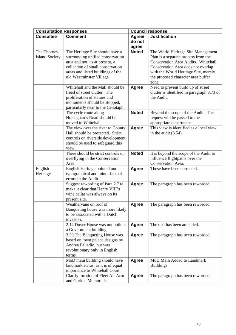
Consultation Responses Council response Consultee Comment Agree/ Justification
do not agree
The Thorney Island Society
The Heritage Site should have a surrounding unified conservation area and not, as at present, a collection of small conservation areas and listed buildings of the old Westminster Village.
The World Heritage Site Management Plan is a separate process from the Conservation Area Audits. Whitehall Conservation Area does not overlap with the World Heritage Site, merely the proposed character area buffer zone.
Noted
Whitehall and the Mall should be freed of street clutter. The proliferation of statues and monuments should be stopped, particularly near to the Cenotaph.
Need to prevent build up of street clutter is identified in paragraph 3.73 of the Audit.
Agree
The cycle route along Horseguards Road should be moved to Whitehall
Beyond the scope of the Audit. The request will be passed to the appropriate department.
Noted
The view over the river to County Hall should be protected. Strict controls on riverside development should be used to safeguard this view
This view is identified as a local view in the audit (3.54).
Agree
There should be strict controls on overflying in the Conservation Area
It is beyond the scope of the Audit to influence flightpaths over the Conservation Area.
Noted
English Heritage
English Heritage pointed out typographical and minor factual errors in the Audit
These have been corrected. Agree
Suggest rewording of Para 2.7 to make it clear that Henry VIII’s wine cellar was always on its present site.
The paragraph has been reworded. Agree
Weathervane on roof of Banqueting house was more likely to be associated with a Dutch invasion.
The paragraph has been reworded Agree
2.14 Dover House was not built as a Government building
The text has been amended. Agree
3.29 The Banqueting House was based on town palace designs by Andrea Palladio, but was revolutionary only in English terms.
The paragraph has been reworded Agree
MoD main building should have landmark status, as it is of equal importance to Whitehall Court.
MoD Main Added to Landmark Buildings.
Agree
Clarify location of Fleet Air Arm and Gurkha Memorials.
The paragraph has been reworded Agree
48

Consultation Responses Council response Consultee Comment Agree/ Justification
do not agree
Dickens has a plaque on Derby Gate, not a Statue. There is also a fine commemorative plaque to Richard Norman Shaw, on the Norman Shaw North building riverfront.
The paragraph has been reworded Agree
2.18, 3.2, 3.11, 3.24 GOGGS – While referring to the list title of ‘New Government Offices’ may be the best choice, it may need some clarification. Suggest that:
2.18 Should Read “The New
Government Offices, built as the New Public Offices in 1898”.
Agree Text amended 3.24 should read: “the New
Government Offices, now commonly known as Government Offices Great George Street or GOGGS”.
Text Amended Agree
3.8 Last sentence EH suggest “The lawn to the west of MoD main building provides relief to it’s massive scale and opens the street space to provide a counterpoint to the processional route.”
The paragraph has been reworded Agree
Gwydyr House is misleadingly included in 3.29 under Royal, Military and Police buildings. Although it can be referred to here as completing the group, its main entry should be in or after 3.34 and could usefully be referred to as ‘currently occupied by the Wales Office’.
A description of Gwydyr House Has been inserted at section 3.34
Noted
3.30 Admiralty buildings should be in Government Buildings section
The Admiralty fits more easily into the thematic area of military buildings than government, especially given that the Citadel forms the western elevation.
Do not Agree
3.62 Sentence commencing ‘numerous cast iron’ would read better as ‘St. Stephens Tavern on Bridge Street also has decorative ironwork to the balconies on first and second floors and on the roof, and cast iron columns on the side elevation’.
The paragraph has been reworded Agree
3.64 Should also contain reference to St. Stephens Tavern, and the renovation programme.
This has been added Agree
49

Consultation Responses Council response Consultee Comment Agree/ Justification
do not agree
3.2 The buildings in the southern most part of the conservation area are not located in the World Heritage Site.
These buildings are contained within the World Heritage Site Character Area buffer zone. The Audit has been changed accordingly.
Agree
Hierarchy of Plan Form is a term which has been used consistently across the Audits adopted so far. It accurately describes the distinction between open and enclosed, busy and quiet spaces.
Hierarchy of Plan Form – Is there not a better, clearer heading? E.g. ‘urban character’
Do not agree
Unlisted buildings of merit. What are these? The term is not consistent with, nor defined in, the UDP. We assume that it refers to buildings which contribute positively/ significantly to the character and appearance of the area.
The identification of unlisted buildings of merit is encouraged in the EH Conservation area appraisals guidance (part vi). The term has been used consistently from the start of the CA audit programme with the support of EH
Noted
The section concerning Bazalgette (2.16) has been expanded and a new paragraph added (2.17).
Victoria Embankment. We are seriously concerned by the omission of references to the history, development and intrinsic value of Victoria Embankment, and its sub-structures (including the Metropolitan District Railway) and its massive significance in conservation area terms.
Agree
Section 3.3 has also been expanded to emphasise the importance of Victoria Embankment.
50

WESTMINSTER CITY COUNCIL STATEMENT OF DECISION SUBJECT: Whitehall Conservation Area Audit – Adoption as
Supplementary Planning Guidance Notice is hereby given that Councillor Robert Davis, the Cabinet Member for Customer Services, has made the following executive decision on the above mentioned subject for the reasons set out below. Summary of Decision: 1) Adopted the Whitehall Conservation Area Audit as set out at Appendix 4 of the report as Supplementary Planning Guidance. 2) Agreed to undertake the formal designation process on the proposed extensions to the conservation area listed in paragraphs 5.1 and 5.2 of the report. Reason for Decision: The Whitehall Conservation Area Audit has been through a comprehensive programme of public consultation. The adoption of such documents as supplementary guidance is a statutory duty and the Whitehall Conservation Area Audit will help guide development sympathetically in the future. This document has gained considerable public support. This document specifically relates Council Unitary Development Plan policies to the local area as encouraged by best practice. Failure to do so would weaken the Council’s position in implementing its borough wide policies when determining applications. The areas put forward for analysis during the formal designation process in this report are those suggested during the consultation process. C T Wilson Director of Legal and Administrative Services Westminster City Hall 64 Victoria Street LONDON SW1E 6QP Publication Date: 19 December 2003 Decision Ref: no. CMfCS/21/2003
51