White Earth State Forest
2
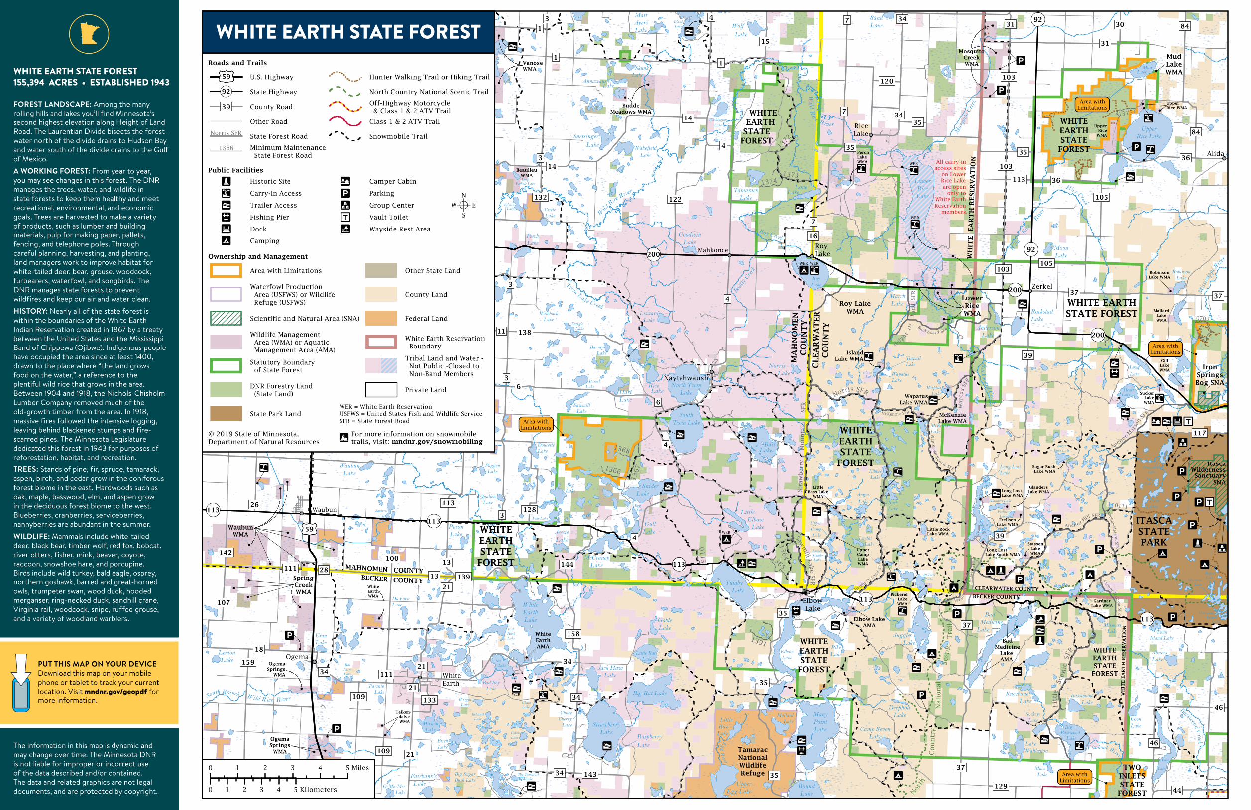
WHITE EARTH STATE FOREST 155,394 ACRES • ESTABLISHED 1943 FOREST LANDSCAPE: Among the many rolling hills and lakes you’ll find Minnesota’s second highest elevation along Height of Land Road. The Laurentian Divide bisects the forest— water north of the divide drains to Hudson Bay and water south of the divide drains to the Gulf of Mexico. A WORKING FOREST: From year to year, you may see changes in this forest. The DNR manages the trees, water, and wildlife in state forests to keep them healthy and meet recreational, environmental, and economic goals. Trees are harvested to make a variety of products, such as lumber and building materials, pulp for making paper, pallets, fencing, and telephone poles. Through careful planning, harvesting, and planting, land managers work to improve habitat for white-tailed deer, bear, grouse, woodcock, furbearers, waterfowl, and songbirds. The DNR manages state forests to prevent wildfires and keep our air and water clean. HISTORY: Nearly all of the state forest is within the boundaries of the White Earth Indian Reservation created in 1867 by a treaty between the United States and the Mississippi Band of Chippewa (Ojibwe). Indigenous people have occupied the area since at least 1400, drawn to the place where “the land grows food on the water,” a reference to the plentiful wild rice that grows in the area. Between 1904 and 1918, the Nichols-Chisholm Lumber Company removed much of the old-growth timber from the area. In 1918, massive fires followed the intensive logging, leaving behind blackened stumps and fire- scarred pines. The Minnesota Legislature dedicated this forest in 1943 for purposes of reforestation, habitat, and recreation. TREES: Stands of pine, fir, spruce, tamarack, aspen, birch, and cedar grow in the coniferous forest biome in the east. Hardwoods such as oak, maple, basswood, elm, and aspen grow in the deciduous forest biome to the west. Blueberries, cranberries, serviceberries, nannyberries are abundant in the summer. WILDLIFE: Mammals include white-tailed deer, black bear, timber wolf, red fox, bobcat, river otters, fisher, mink, beaver, coyote, raccoon, snowshoe hare, and porcupine. Birds include wild turkey, bald eagle, osprey, northern goshawk, barred and great-horned owls, trumpeter swan, wood duck, hooded merganser, ring-necked duck, sandhill crane, Virginia rail, woodcock, snipe, ruffed grouse, and a variety of woodland warblers. PUT THIS MAP ON YOUR DEVICE Download this map on your mobile phone or tablet to track your current location. Visit mndnr.gov/geopdf for more information. The information in this map is dynamic and may change over time. The Minnesota DNR is not liable for improper or incorrect use of the data described and/or contained. The data and related graphics are not legal documents, and are protected by copyright.
Transcript of White Earth State Forest
WHITE EARTH STATE FOREST155,394 ACRES • ESTABLISHED 1943
FOREST LANDSCAPE: Among the many rolling hills and lakes you’ll find Minnesota’s second highest elevation along Height of Land Road. The Laurentian Divide bisects the forest—water north of the divide drains to Hudson Bay and water south of the divide drains to the Gulf of Mexico.A WORKING FOREST: From year to year, you may see changes in this forest. The DNR manages the trees, water, and wildlife in state forests to keep them healthy and meet recreational, environmental, and economic goals. Trees are harvested to make a variety of products, such as lumber and building materials, pulp for making paper, pallets, fencing, and telephone poles. Through careful planning, harvesting, and planting, land managers work to improve habitat for white-tailed deer, bear, grouse, woodcock, furbearers, waterfowl, and songbirds. The DNR manages state forests to prevent wildfires and keep our air and water clean.HISTORY: Nearly all of the state forest is within the boundaries of the White Earth Indian Reservation created in 1867 by a treaty between the United States and the Mississippi Band of Chippewa (Ojibwe). Indigenous people have occupied the area since at least 1400, drawn to the place where “the land grows food on the water,” a reference to the plentiful wild rice that grows in the area. Between 1904 and 1918, the Nichols-Chisholm Lumber Company removed much of the old-growth timber from the area. In 1918, massive fires followed the intensive logging, leaving behind blackened stumps and fire-scarred pines. The Minnesota Legislature dedicated this forest in 1943 for purposes of reforestation, habitat, and recreation. TREES: Stands of pine, fir, spruce, tamarack, aspen, birch, and cedar grow in the coniferous forest biome in the east. Hardwoods such as oak, maple, basswood, elm, and aspen grow in the deciduous forest biome to the west. Blueberries, cranberries, serviceberries, nannyberries are abundant in the summer.WILDLIFE: Mammals include white-tailed deer, black bear, timber wolf, red fox, bobcat, river otters, fisher, mink, beaver, coyote, raccoon, snowshoe hare, and porcupine. Birds include wild turkey, bald eagle, osprey, northern goshawk, barred and great-horned owls, trumpeter swan, wood duck, hooded merganser, ring-necked duck, sandhill crane, Virginia rail, woodcock, snipe, ruffed grouse, and a variety of woodland warblers.
PUT THIS MAP ON YOUR DEVICE Download this map on your mobile phone or tablet to track your current location. Visit mndnr.gov/geopdf for more information.
The information in this map is dynamic and may change over time. The Minnesota DNR is not liable for improper or incorrect use of the data described and/or contained. The data and related graphics are not legal documents, and are protected by copyright.
FOR_660_19
WHITE EARTH!
WHITE EARTH STATE FOREST MAP
MAP AN
D G
UID
E
GENERAL STATE FOREST RULESWhether you are camping, hunting, riding, geocaching, skiing, or gathering berries, take care to leave the forest in good condition.• Forest lands are open at all times unless otherwise posted closed.• Tribal lands may be closed to non-band members. Contact 218-983-3285.• Pack out what you pack in. Remove all personal property. Do not burn litter or garbage.• Don’t leave equipment unattended for more than 24 hours.• Building permanent structures, including deer stands, is prohibited.• Use firewood purchased by vendors who harvested firewood in the same county as the
state forest or harvested in Minnesota and certified by the Minnesota Department of Agriculture or USDA. Bring your receipt. You may also collect dead firewood on site. Kiln-dried, unstained, unpainted dimensional lumber free from metal or other foreign objects is also permitted. It is illegal to bring in any other firewood. These rules are to prevent accidentally introducing harmful pests such as emerald ash borer. mndnr.gov/firewood
• Fireworks are prohibited on all state, county, and federal lands. • Keep campfires no larger than 3 feet wide and 3 feet high. Attend the fire at all times.
Completely extinguish fires before leaving the area. It should be cold to the touch.• Bury human waste (if vault toilets are not available) and animal parts such as fish guts at
least 150 feet from a water body and away from areas where it could cause a nuisance or hazard to public health.
• On state-managed lands, - We do not require permits to collect berries, mushrooms, balsam boughs, or dead
fuelwood for personal use while in the forest. However collecting large amounts of any item for sale requires a permit from the local DNR forestry office. mndnr.gov/areas/forestry
- Wild rice, Minnesota’s state grain, is abundant in the area and may be harvested when ripe unless posted otherwise. State permit required. mndnr.gov/regulations/wildrice
• On tribal lands:- Band members may collect berries, mushrooms, balsam boughs, fuelwood, and wild rice.- There may be more restrictions for non-band members who collect wild rice, fuelwood,
and other items. Contact 218-983-3285.• This is a partial list of rules. For more information, visit the website listed below.
mndnr.gov/forestrules
CAMPINGThere are no developed campgrounds in this state forest.Dispersed camping with no amenities is allowed on state forest land. Summer camping is limited to 14 days. Winter camping is limited to 21 days between the second Sunday in September and the first Saturday in May. LONG LAKE COUNTY PARK – CLEARWATER COUNTYThis campground has 89 campsites (31 with electric hook-ups), walking trail, sandy swimming beach and fishing on Long Lake. Reservations required and fees charged. https://longlakepark.com ROY LAKE AND LITTLE ELBOW PARKS – WHITE EARTH TRIBEThese scenic parks are open to the public. Roy Lake has a public boat launch and dock. Little Elbow has a picnic area and a campground. White Earth tribal permit required. Fees may be charged. 218-983-3285
TRAILSAll trails and roads are open to hiking, horseback riding, mountain biking, and cross-country skiing unless posted closed. Off-trail hiking, country-skiing, and snowshoeing are allowed.NORTH COUNTRY HIKING TRAILThis trail is complete all the way across Hubbard County through Itasca State Park and into Becker County to the Hubble Pond Wildlife Management Area. Eventually, the trail will link to a larger corridor similar to the Appalachian Trail that will traverse more than 4,000 miles through seven northern states from North Dakota to New York. For interactive maps and to download GIS/GPS data, visit http://northcountrytrail.org/MinnesotaSNOWMOBILE TRAILSHundreds of miles of groomed snowmobile trails wind their way through the hilly forest and connect to nearby trails. Trails are open between December 1 and April 1 and may be plowed during the winter for logging activities. Trails are marked with orange signs.• Snowmobile trail maps: mndnr.gov/
snowmobiling/interactive_map• Snowmobiles must be registered. See
mndnr.gov/regulations/snowmobile
OFF-HIGHWAY VEHICLE TRAILSThis state forest offers several miles of forest roads open to all-terrain vehicles (ATVs), off-road vehicles (ORVs), and off-highway motorcycles (OHMs).• Non-residents must have an ATV Trail
Pass. findthetrails.com • ATVs, ORVs, and OHMs must be
registered. mndnr.gov/licenses/ohv• Visit mndnr.gov/ohv for up-to-date rules,
maps, and trail and road closures.CLASSIFICATION: LIMITEDAll trails on state lands are classified regarding motor vehicles.White Earth State Forest is classified as “limited.” ATVs and off-highway motorcycles are allowed on signed forest roads or trails unless posted closed. ATV travel off signed trails or roads is prohibited except for persons lawfully engaged in hunting big game or erecting temporary stands during October-December, retrieving big game during September, or trapping during open seasons. KNOW YOUR VEHICLEAlways make sure you are riding on the appropriate trail, designated and signed for your vehicle. Off-highway vehicles must display a current Minnesota registration sticker. mndnr.gov/licenses/ohv
HUNTING AND TRAPPING Hunting and trapping is allowed during the appropriate season and with the correct license in state forests, Wildlife Management Areas (AMAs), and Aquatic Management Areas (AMAs) posted as General Use. These areas may contain private land within their boundaries, and may be signed “no hunting.” mndnr.gov/huntingFIREARMS AND BOWSFirearms must be unloaded and cased and bows must be cased while in or within 200 feet of a forest recreation area (campground, day-use area, parking area), except that during open hunting seasons licensed hunters may carry an unloaded, uncased firearm or uncased bow to hunt outside the recreation area. Cutting shooting lanes is not allowed on any state or federal land.Building permanent structures, including deer stands, is prohibited. For a complete list of regulations about hunting, trapping, firearms, bows, limits, seasons, and deer stands on state-managed land, visit mnndr.gov/regulations/hunting
WILDLIFE MANAGEMENT AREAS WMAs are managed to provide quality habitat for a variety of species, especially deer, bear, grouse, woodcock, and waterfowl, along with owls, warblers, butterflies, and woodpeckers. WMAs provide opportunities for public hunting, trapping, fishing, and wildlife observation. Hunting is generally allowed with the proper license and during the proper seasons in WMAs. Trapping is also generally allowed, but taking beaver and otter requires a permit from the wildlife manager. WMA HIGHLIGHT: Island Lake Island lake WMA is located on the northeast portion of Island Lake, a designated trout lake. WMA HIGHLIGHT: Upper RiceThis 1,860-acre lake hosts migratory waterfowl and wild rice. Mixed grassland, wetland, and forest surround the lake. WMA maps: mndnr.gov/maps/compassWMA information: mndnr.gov/wmasAQUATIC MANAGEMENT AREAS (AMAs)AMAs are established to protect, develop, and manage lakes, rivers, streams, and wetlands critical for fish and aquatic life, for water quality, and for their intrinsic biological value. AMAs provide access to shorelines, and are open to fishing and other compatible outdoor recreational uses. Hunting is prohibited in AMAs posted as Restricted Use. mndnr.gov/amas
FISHINGLakes in the area offer opportunities to catch walleye, northern pike, bass, panfish, and trout. There are no special provisions or restrictions on fishing in state forests. You must have the proper license and abide by the same rules and seasons as anywhere else in Minnesota. Most of the small lakes in the state forest have carry-in canoe access, and many of the larger lakes have modern boat launches.
Avoid spreading invasive organisms such as zebra mussel larvae and spiny waterfleas by not transporting lake or river water, including in bait buckets or on other recreational equipment. Dispose unused bait and live worms in trash containers or pack them out where they can’t reach water or soil.Visit mndnr.gov/fishing for up-to-date regulations.Visit mndnr.fov/lakefind for current information on specific lakes.
NEARBY RECREATIONITASCA STATE PARKThis popular park surrounds Lake Itasca, the headwaters of the 2,350-mile Mississippi River. The park features a variety of camping opportunities, including the Historic Douglas Lodge, cabins, and several developed campgrounds. Historic sites in the park include the Aiton Heights Fire Tower, old-growth forests, and the Old-Timer’s Cabin. Visitors can enjoy miles of hiking and cross-country ski trails, and 6 miles of paved bike trail. More information: mndnr.gov/state_parks/Itasca TAMARAC NATIONAL WILDLIFE REFUGE – U.S. FISH AND WILDLIFE SERVICE With coniferous and deciduous forests, marshes, and wetlands, this refuge is home to wildlife such as trumpeter swans, gray wolves, and golden-winged warblers. Tamarac is open to deer, duck, and small game hunting. The refuge also provides hiking and cross-country ski trails. For more information, regulations, and maps, visit: www.fws.gov/refuge/tamarac
RESPECT PRIVATE PROPERTYState forests contain private and tribal land within their boundaries. Watch for posted “No Trespassing” and “No Hunting” signs and stay off private property.You must have permission before entering tribal or posted private land, even to cross it to access public land.Trespassing is a misdemeanor. If convicted, you could lose your license to hunt. All conservation and peace officers enforce trespass laws.
ALWAYS STAY ON SIGNED TRAILSWhether you’re riding or walking, tread lightly on the land. Be courteous to others, respect private property, and obey the law.
AREAS WITH LIMITATIONSThese areas are designated to protect unique natural resources and provide other non-motorized recreation opportunities. Motorized vehicles may not operate within “Areas with Limitations” for any reason, including retrieving big game.
LEAVE TROUBLE BEHINDHelp prevent the spread of invasive plants and animals.• Clean your gear before entering and leaving the recreation site.• Remove mud and seeds from clothes, pets, boots, gear, vehicles, and watercraft.• Stay on designated trails.• PlayCleanGo.org
FOR MORE INFORMATIONMinnesota Department of Natural [email protected] | 888-646-6367TDD (Telecommunications Device for the Deaf)651-296-5484 | 800-657-3929
DNR TIP LINE (Turn in Poachers)800-652-9093
EMERGENCY SERVICE - DIAL 911CLEARWATER COUNTY SHERIFF218-694-6226
MAHNOMEN COUNTY SHERIFF218-935-2255
NEAREST HOSPITAL SERVICESEssentia Health St. Mary’s, Detroit Lakes218-844-2347CHI St. Joseph’s Health, Park Rapids218-732-3311Sanford Medical Center, Bagley218-694-6501Mahnomen Health Center, Mahnomen218-935-2511The Minnesota DNR prohibits discrimination in its programs and services based on race, color, creed, religion, national origin, sex, public assistance status, age, sexual orientation or disability. Persons with disabilities may request reasonable modifications to access or participate in DNR programs and services by contacting the DNR ADA Title II Coordinator at [email protected] or 651-296-6157. Discrimination inquiries should be sent to Minnesota DNR, 500 Lafayette Road, St. Paul, MN 55155-4049; or Office of Civil Rights, U.S. Department of the Interior, 1849 C. Street NW, Washington, D.C. 20240.
© 2019, State of Minnesota, Department of Natural Resources
Printed on Minnesota made paper containing a minimum of 10 percent post-consumer waste.
FORESTRY500 Lafayette Road, St. Paul, MN 55155
888-646-6367mndnr.gov