The Moveable “Desert Maker” Phil Gersmehl Michigan Geographic Alliance Climate Change in History.
Upload
rodney-bakerCategory
view
214download
1
WHERE and WHY?
Marty Mater and Phil Gersmehl Michigan Geographic Alliance
BIG IDEA: REGIONS IN THE U. S.
1

Objectives: The student will
BIG IDEA: REGIONS IN THE U. S.
• Describe characteristics of natural regions
• Divide United States into major regions
• Explain relationship between physical characteristics and human activities
2

National Geography Standards• The World in Spatial Terms:
Use maps…and spatial thinking to understand and communicate information.
• Places and Regions: That people create regions to interpret Earth’s complexity.
BIG IDEA: REGIONS IN THE U. S.
3

BIG IDEA: REGIONS IN THE U. S.
RegionA geographic “BIG IDEA”that can help us organize
our knowledge about
the United States4

There are many kinds of regional maps
Economic regions
Sports regions
Forest regions
Voting regions
Language regions
Definition: a region is a group of places that are like each other and close to each other
5
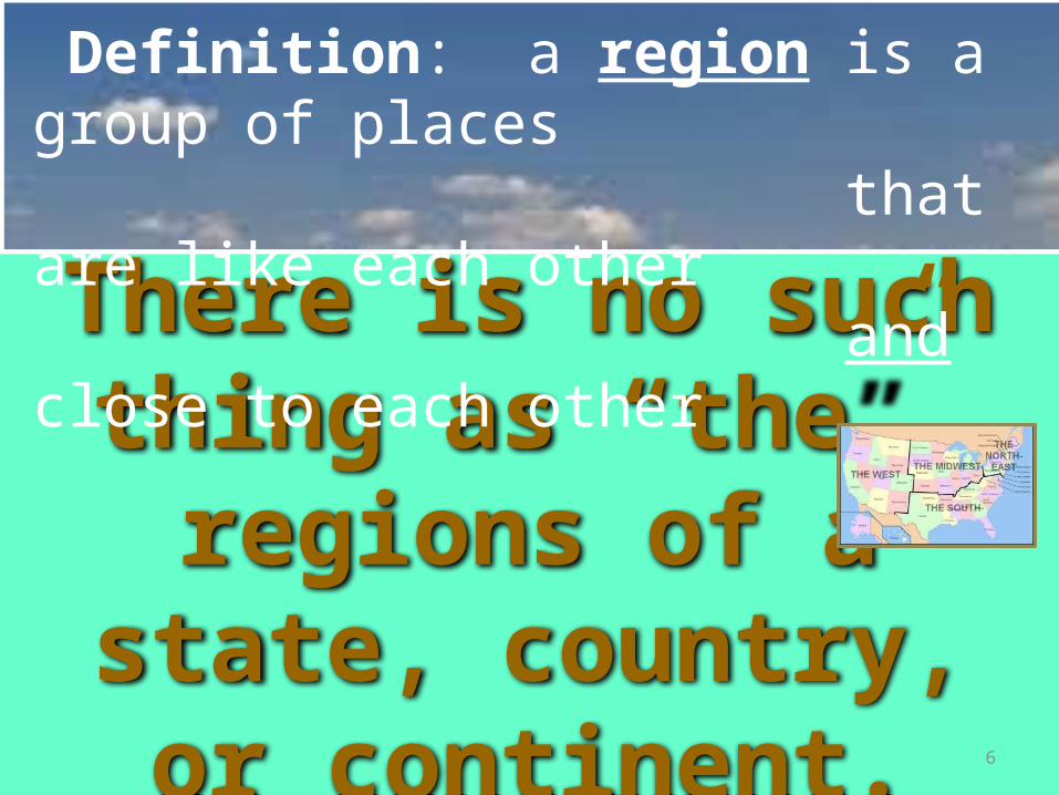
There is no such thing as “the”
regions of a state, country, or continent.
Definition: a region is a group of places that are like each other and close to each other
6

We will use natural characteristics to regionalize the US
Definition: a region is a group of places that are like each other and close to each other
7

Great Lakes
Atlantic Ocean
Pacific Ocean
Mexico
Canada
Gulf of Mexico8
Work Map

Definition: a region is a group of places that are like each other and close to each other
Natural characteristics can make it advantageous or disadvantageous to live in an area.
TERRAIN:Mountains
Plains WATER
BALANCE:Enough water to grow trees
GROWING SEASON:Number of
frost-free days9

Rocky
Mountains.
Sierra
Mountains.
Appalach
ian
Mounta
ins.
Great Plains
Terrain: Mountains, Plains
10

Growing Season: Number of frost-free days
11

Water balance: Enough water to grow trees
12
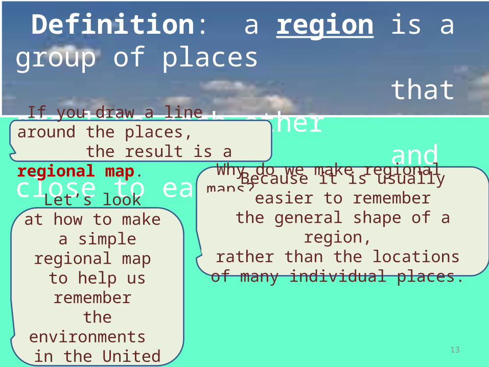
Definition: a region is a group of places that are like each other and close to each other If you draw a line around the places, the result is a regional map.
Why do we make regional maps?
Because it is usually easier to rememberthe general shape of a region,
rather than the locations of many individual places.
Let’s look at how to make
a simple regional map to help us remember
the environments in the United States.
13

The Western Region of high mountains and
deep valleys
The Eastern Region of worn-down mountains and
nearly flat plains
Terrain: Mountains, Plains
14

Terrain: Mountains, Plains
15

• Most of the land is more than a mile above sea level
• It is easier to build roads and railroads
• There are more big tunnels, steep slopes, and spectacular views
• Most valuable metal mines are here
• Most deposits of fossil fuels are here
• Most of the good food-producing land is here
• Most of the major earthquakes and all of the active volcanoes occur here
CONSEQUENCES OF THE TERRAIN
Western Region or Eastern Region?
16

More than a mile above sea level
Roads and Railroads
Tunnels, slopes, views
Valuable mines
Fossil fuels
Food producers
Earthquakes and volcanoes
Terrain: Mountains, Plains
17

Definition: a region is a group of places that are like each other and close to each other
Our first line was drawn based on
TERRAIN.
Now we’ll use the idea of GROWING SEASON
to divide the area into places with enough frost-free days
to grow crops. 18

Atlantic Ocean
Very few farms
Manyfarms
Growing Season: Number of frost-free days
19

Very few farms
Manyfarms
Growing Season: Number of frost-free days
20

Growing Season: Number of frost-free days
Very few farms
Manyfarms
21

Definition: a region is a group of places that are like each other and close to each other
Our first line was drawn based on TERRAIN
Our second line used
GROWING SEASON
Now we’ll use WATER BALANCE to show the line that separates places that have
more precipitation than trees needfrom places that have less 22

Water balance: Enough water to grow trees
Semi-arid
Great Plains
Rainy East
23

Water balance: Enough water to grow trees
Semi-arid
Great Plains
Rainy East
24

• People grow crops such as corn, soybeans, and vegetables. • People grow short grasses like wheat and barley.• People grow tree crops like apples, pears, cherries, and even
oranges and grapefruit.• People are more likely to need to irrigate, if they have a water
source.• There is always a danger of drought, which can kill the crops.• Surplus water can make rivers or lakes. • Rivers start in the mountains and actually get smaller as they
flow.• Rivers tend to get larger as they flow toward the ocean.
CONSEQUENCES OF WATER BALANCE
Semi-Arid or Rainy East?
25

Water balance: Enough water to grow trees
Corn, soybeans
short grasses
apples, pears
irrigate
drought
rivers or lakes
Rivers get
smaller
rivers get
larger
26

Definition: a region is a group of places that are like each other and close to each other
Our first line was drawn based on TERRAIN
Our second line used
GROWING SEASON
Now we’ll use GROWING SEASON again to show the line that separates places that have
more than 7 months of frost-free days.
Our third line used WATER
BALANCE
27

Growing Season: Number of frost-free days
28

Growing Season: Number of frost-free days
29

Terrain: Mountains, Plains
30

Terrain: Mountains, Plains
31

Growing Season: Number of frost-free days
4-7 Months
7+ months
32

CONSEQUENCES OF FROST-FREE MONTHS
• People spend more money for heating
• People spend more money for air-conditioning
• Dead leaves and roots decay slowly, making soil rich in
nutrients
• Dead leaves and roots decay quickly, making soil red or
orange in color, and unable to store water or fertilizer as well
• Trees grow faster, so there are many managed forests
• Glaciers left many scattered lakes and swamps33

Growing Season: Number of frost-free days
Scattered Lakes and swamps
Managed Forests
High Heating
Rich Soils
Soil can’t hold
water
Expensive Air Conditioning
34
Let’s Review - and name our
regions
Look at the lines on your map.
35

Can you remember the lines and what they mean?..
Western Mountain Region
36

Western Mountain Region
younger rocks, earthquakes, high mountains,dry lowlands, rainy slopes with forests, snow on the highest peaks, ski resorts,
metal mines, scattered cities, national parks
37

Can you remember the lines and what they mean?..
Western Mountain Region
Northern Cold Region
38

Northern cold region
older rocks, low hills or plains, many lakes,dense forests of slow-growing needleleaf trees ORtreeless tundra in places with really short summers,very few people, few roads, some mines, oil wells
39

Can you remember the lines and what they mean?..
Western Mountain Region
Northern Cold Region
Great Plains
Grassland Region
40

Great Plains Grassland Region
young rocks, flat plains or low hills, dry creeks,grassland, bison (buffalo), cattle ranches, some wheat fields, some irrigated areas,
scattered towns, oil wells, occasional tornadoes
41

Can you remember the lines and what they mean?..
Western Mountain Region
Northern Cold Region
Great Lakes Farm/Forest
Region
Great Plains
Grassland Region
42
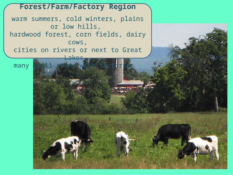
Great Lakes Forest/Farm/Factory Region
warm summers, cold winters, plains or low hills, hardwood forest, corn fields, dairy cows,cities on rivers or next to Great Lakes,
many small towns with factories
43

Can you remember the lines and what they mean?..
Western Mountain Region
Southern Plantation/Pine
Region
Northern Cold Region
Great Lakes Farm/Forest
Retion
Great Plains
Grassland Region
44

Southern Plantation / Pine Region
long summers, mild winters, fast-growing forest,red soil, cotton plantations, slavery, Civil War,
sharecroppers, boll weevil, planted pines,paper mills, some new factories (e.g., cars)
45

Using regions to explain human characteristics
Using maps of the physical characteristics
of our regions, can you explain why humans decided to use the land
for growing certain crops?
Would knowing about the physical characteristics of our regions help you describe some requirements
for growing cotton, corn or wheat?
46

Corn Production in the United States
47

REGIONS IN THE US
1. Outline the “region” of crop production in the United States.
REGIONS IN THE UNITED STATES
48

2. Describe the area you outlined by using some of the following words:
near, next to, inside,west, east, south, north, northeast, southeast, northwest, southwest
Also use some place names.
Bodies of Water
Countries
States
REGIONS IN THE UNITED STATES
49

REGIONS IN THE US
3. Describe terrain of your crop region.
4. Describe the water balance in your crop region.
5. Describe the growing season of your crop region.
REGIONS IN THE UNITED STATES
50

Rice Production in the United States
51

Wheat Production in the United States
52
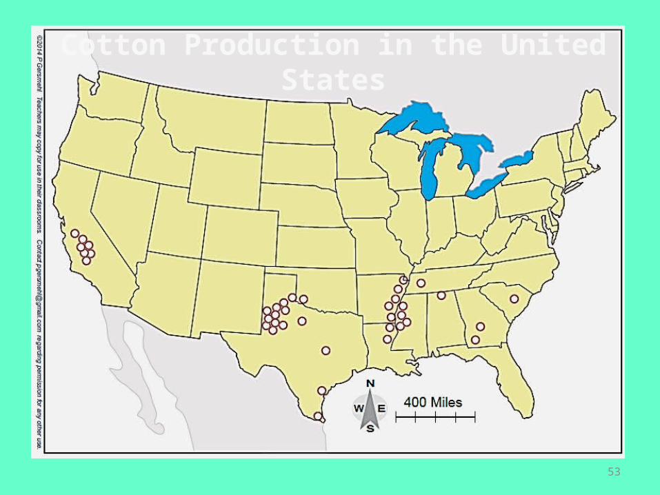
Cotton Production in the United States
53

Knowing the approximate location of these four lines can help us organize a lot of other knowledge about environments in North America….
So What?Putting it all together:
If we remember:
54

They are generalizations based on measurements and human choices about what criteria are important..
Regions can help us organize
knowledge…
Regional lines are not “real.”
55
BUT
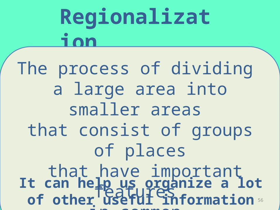
Regionalization
The process of dividing a large area into smaller
areas that consist of groups of
places that have important features
in common.It can help us organize a lot of other useful information about our country.56

Can you remember the lines and what they mean?..
Western Mountain Region
Southern Plantation/Pine
Region
Northern Cold Region
Great Lakes Farm/Forest
Retion
Great Plains
Grassland Region
57

REGIONS IN THE US
1. Choose at least one of the human characteristics on the following maps.
2. Write at least two questions relating your crop to a characteristic shown on these maps.
REGIONS IN THE UNITED STATES
58

Markets for food crops: Symbols show largest urban areas.
NewYork
LosAngeles
Chicago

Markets: Clusters of dots show large urban areas.
NewYork
LosAngeles
Chicago
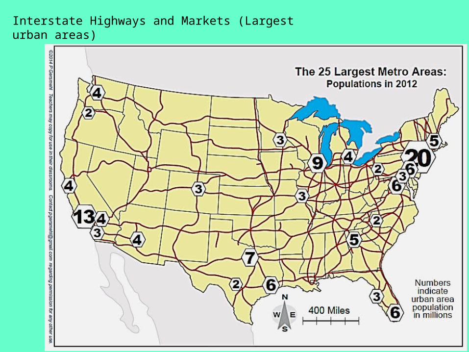
Interstate Highways and Markets (Largest urban areas)
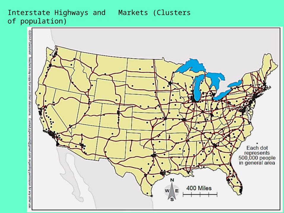
Interstate Highways and Markets (Clusters of population)