Wheatstone Project - NOPSEMA...stabilisation (this Plan) summarises the Wheatstone Project...
23
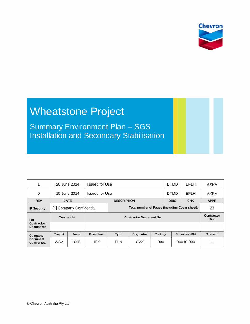
© Chevron Australia Pty Ltd 1 20 June 2014 Issued for Use DTMD EFLH AXPA 0 10 June 2014 Issued for Use DTMD EFLH AXPA REV DATE DESCRIPTION ORIG CHK APPR IP Security Company Confidential Total number of Pages (including Cover sheet): 23 For Contractor Documents Contract No Contractor Document No Contractor Rev. Company Document Control No. Project Area Discipline Type Originator Package Sequence-Sht Revision WS2 1665 HES PLN CVX 000 00010-000 1 Wheatstone Project Summary Environment Plan – SGS Installation and Secondary Stabilisation
Transcript of Wheatstone Project - NOPSEMA...stabilisation (this Plan) summarises the Wheatstone Project...
© Chevron Australia Pty Ltd
1 20 June 2014 Issued for Use DTMD EFLH AXPA
0 10 June 2014 Issued for Use DTMD EFLH AXPA
REV DATE DESCRIPTION ORIG CHK APPR
IP Security Company Confidential Total number of Pages (including Cover sheet): 23
For Contractor Documents
Contract No Contractor Document No Contractor
Rev.
Company Document Control No.
Project Area Discipline Type Originator Package Sequence-Sht Revision
WS2 1665 HES PLN CVX 000 00010-000 1
Wheatstone Project Summary Environment Plan – SGS Installation and Secondary Stabilisation

Wheatstone Project Document No: WS2-1665-HES-PLN-CVX-000-00010-000 Summary Environment Plan – SGS Installation and Secondary Stabilisation
Revision: 1 Revision Date: 20/6/2014
© Chevron Australia Pty Ltd Page 2
Printed Date: 20/6/2014 Uncontrolled when printed
Page left blank intentionally.
Wheatstone Project Document No: WS2-1665-HES-PLN-CVX-000-00010-000 Summary Environment Plan – SGS Installation and Secondary Stabilisation
Revision: 1 Revision Date: 20/6/2014
© Chevron Australia Pty Ltd Page 3
Printed Date: 20/6/2014 Uncontrolled when printed
TABLE OF CONTENTS
1.0 INTRODUCTION ............................................................................................................ 4
1.1 Location ................................................................................................................. 4 1.2 Timeframe ............................................................................................................. 4 1.3 Operator Details .................................................................................................... 4
2.0 ACTIVITY DESCRIPTION .............................................................................................. 6
2.1 Planned Activity Summary .................................................................................... 6 2.2 Pre-Installation Activities ....................................................................................... 6 2.3 SGS Installation ..................................................................................................... 7 2.4 Post SGS Installation Activities ............................................................................. 7
2.4.1 Bouyancy Tank Removal ......................................................................... 7 2.4.2 Scour Protection ...................................................................................... 7 2.4.3 SGS Clean Up ......................................................................................... 8
2.5 Secondary Stabilisation ......................................................................................... 8 2.6 Supporting Activities .............................................................................................. 8
2.6.1 Support Vessels ...................................................................................... 8 2.6.2 Helicopter Operations .............................................................................. 9
2.7 Emergency Condition Summary ............................................................................ 9
3.0 DESCRIPTION OF THE ENVIRONMENT ................................................................... 10
3.1 Physical Environment .......................................................................................... 10 3.2 Ecological and Socio-economic Environment ..................................................... 10
4.0 MAJOR ENVIRONMENTAL HAZARDS AND CONTROLS ........................................ 16
5.0 MANAGEMENT APPROACH ...................................................................................... 20
5.1 Roles and Responsibilities .................................................................................. 20 5.2 Training and Competency ................................................................................... 20 5.3 Monitoring and Reporting .................................................................................... 20 5.4 Compliance assurance ........................................................................................ 20 5.5 Documentation and Records ............................................................................... 20 5.6 Environment Plan Review ................................................................................... 21
6.0 CONSULTATION ......................................................................................................... 22
6.1 Stakeholder Identification and Analysis ............................................................... 22 6.2 Communication Engagement Plan ...................................................................... 22
7.0 CONTACT DETAILS .................................................................................................... 23
TABLES
Table 1: Areas of conservation significance and key ecological features which occur within the EMBA ................................................................................................ 11
Table 2: Summary of Major Hazards, Potential Environmental Impacts and Controls ......... 17
FIGURES
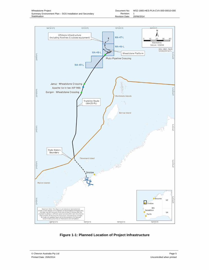
Figure 1-1: Planned Location of Project Infrastructure ............................................................ 5

Wheatstone Project Document No: WS2-1665-HES-PLN-CVX-000-00010-000 Summary Environment Plan – SGS Installation and Secondary Stabilisation
Revision: 1 Revision Date: 20/06/2014
© Chevron Australia Pty Ltd Page 4
Printed Date: 20/6/2014 Uncontrolled when printed
1.0 INTRODUCTION
The Summary Environment Plan – Steel Gravity Structure (SGS) installation and secondary stabilisation (this Plan) summarises the Wheatstone Project Installation Environment Plan – SGS Installation and Secondary Stabilisation (the EP) (Document Number WS2-1665-HES-PLN-CVX-000-00005-000). The EP was accepted by the National Offshore Petroleum Safety Environment Management Authority (NOPSEMA) on 3 June 2014. This Plan has been prepared in accordance with OPGGS(E)R, Division 2.2, Regulation 11(8).
1.1 Location
The activities will be performed at the location of the Wheatstone Platform (WP), as represented in Figure 1-1. The WP is located at Easting 330 860.000 m and Northing 795 520.000 m (UTM Zone 50). These coordinates are based on the Geodetic Datum of Australia (GDA94). The EP considers activities in Commonwealth waters only.
1.2 Timeframe
The SGS is currently expected to be towed to the installation site in Q3 2014 with installation activities expected to take up to 120 days.
Secondary stabilisation of the trunkline and flowlines is expected to take approximately 90 days and will be undertaken between Q3 2014 and Q1 2016.
The timing is indicative, and subject to potential delays caused by weather events, vessel availability and other unforeseen factors.
1.3 Operator Details
Chevron Australia Pty Ltd (Chevron) is the Operator of the Wheatstone Liquefied Natural Gas Project. The Joint Venture Participants in the Project are Australian subsidiaries of Chevron (64.14%), Apache Julimar Pty Ltd (13%), Kuwait Foreign Petroleum Exploration Company Australia (Julimar) Pty Ltd (KUFPEC, 7%), KUFPEC Australia (Wheatstone Iago) Pty Ltd (6.4%), Kyushu Electric Power Company (1.46%) and PE Wheatstone Pty Ltd (part owned by TEPCO, 8%).
Wheatstone Project Document No: WS2-1665-HES-PLN-CVX-000-00010-000 Summary Environment Plan – SGS Installation and Secondary Stabilisation
Revision: 1 Revision Date: 20/06/2014
© Chevron Australia Pty Ltd Page 5
Printed Date: 20/6/2014 Uncontrolled when printed
Figure 1-1: Planned Location of Project Infrastructure
Wheatstone Project Document No: WS2-1665-HES-PLN-CVX-000-00010-000 Summary Environment Plan – SGS Installation and Secondary Stabilisation
Revision: 1 Revision Date: 20/06/2014
© Chevron Australia Pty Ltd Page 6
Printed Date: 20/6/2014 Uncontrolled when printed
2.0 ACTIVITY DESCRIPTION
2.1 Planned Activity Summary
The following activities are addressed in this Plan,
Pre-installation activities
SGS installation
Post SGS Installation activities
Secondary Stabilisation
Supporting activities
The SGS will be towed to the site of the WP and set down using four anchor handling tugs (AHT), dead man anchors (DMAs) and a combination of passive, active and solid ballasting to sink the structure. Once solid ballasting is completed, a final clean up and scour protection of the SGS and rock blanket will be undertaken.
In addition to the AHTs, a Dynamically Positioned Fall Pipe (DPFP) vessel, heavy lift vessel, installation command vessel and supply vessels will be on location to support activities.
Following the installation of the trunkline and flowlines (detailed in separate Plans) secondary stabilisation works will be conducted to ensure the pipelines are appropriately stabilised prior to the introduction of hydrocarbons. Post trunkline installation rock berms are required at the existing pipeline crossings to prevent the trunkline from moving off the previously laid rock berms. Rock berms will also be installed on the trunkline to enable the future tie-in tee.
The operational area for the SGS installation and secondary stabilisation is defined as the petroleum license areas WA-46L, WA-47-L, WA-48-L around the WP, plus a 500 m buffer either side of the petroleum pipeline licence WA-25-PL.
2.2 Pre-Installation Activities
A seabed survey of the previously installed rock blanket (WS2-1665-HES-PLN-CVX-000-00001-000) will be undertaken by the Dynamically Positioned Fall Pipe (DPFP) vessel using survey equipment integrated within the fall pipe Remotely Operated Vehicle (ROV). Multi beam echo sounding (MBES) will be used together with visual aids to confirm the integrity of the rock blanket foundation approximately 14 days prior to the SGS arriving in the operational area. The DPFP will be used to undertake the survey and undertake rock placement to rectify any surface damage of the rock blanket if required.
The DMAs will be installed within the operational area prior to SGS installation at the following approximate locations (Table 2.1). Table 2.1: Approximate DMA Locations
Anchor Location
North anchor 330234 E
7790604 N
Wheatstone Project Document No: WS2-1665-HES-PLN-CVX-000-00010-000 Summary Environment Plan – SGS Installation and Secondary Stabilisation
Revision: 1 Revision Date: 20/06/2014
© Chevron Australia Pty Ltd Page 7
Printed Date: 20/6/2014 Uncontrolled when printed
East anchor 331932 E
7796139 N
West anchor 329837 E
7794938 N
South anchor 331486 E
7794436 N
DMAs will comprise of Stevshark or similar anchors each with approximate dimensions of 7 m x 10 m x 4 m, and will maintain tension to accurately position the SGS. Each anchor chain will be approximately 1.2 km in length with up to 700 m of chain sitting on the seabed per anchor. DMA installation is expected to occur approximately two weeks prior to commencement of SGS installation and last for approximately three days.
2.3 SGS Installation
The SGS is a steel construction with a dry weight of approximately 36 000 tonne (T) and is approximately 104 m long, 80 m wide and 94 m high. The SGS comprises four braced square column legs that are connected by a rectangular ring pontoon. Upon installation the SGS will extend approximately 16m above the sea level at the top deck and 24 m at the stab in point above the sea surface.
The SGS will be wet towed to the WP and placed on top of the rock blanket in a water depth of approximately 70 m. Four vessels will be used to tow and position the SGS. Three Anchor Handling Tugs (AHTs) comprising of two Assisting Tow Tugs (ATTs) and one Main Tow Tug (MTT) will be connected to the SGS by positioning bridles and will tow the SGS, fitted with buoyancy tanks, to the site of the WP.
A fourth vessel, Stand-by Tow Tug (STT), will be connected to the SGS to manage positioning. The SGS will be set down by flooding the pontoons, buoyancy tanks and a series of tanks within the SGS column legs (pods) with sea water through passive and active ballasting. Solid ballast, in the form of iron ore slurry, will be pumped into the four legs of the SGS to provide long term foundation stability.
2.4 Post SGS Installation Activities
2.4.1 Bouyancy Tank Removal
The two external buoyancy tanks will be removed on completion of the SGS installation. Each tank has an approximate diameter of 11 m and is 25 m in height with an approximate weight of 600 T (empty in air). The tanks will be released by ROV and lifted clear of the SGS using a heavy lift vessel or alternative which will then transport the tanks on the vessel to a nominated port for disposal.
2.4.2 Scour Protection
Following installation of the SGS, scour protection will be deployed in the form of a combination of rock placement and concrete mattresses to maintain the integrity of the SGS
Wheatstone Project Document No: WS2-1665-HES-PLN-CVX-000-00010-000 Summary Environment Plan – SGS Installation and Secondary Stabilisation
Revision: 1 Revision Date: 20/06/2014
© Chevron Australia Pty Ltd Page 8
Printed Date: 20/6/2014 Uncontrolled when printed
and rock blanket and prevent erosion. All scour protection, including rock and mattresses, will be positioned directly on top of the existing rock blanket.
2.4.3 SGS Clean Up
Upon completion of passive, active and solid ballasting operations, the active ballast system will be removed from the SGS as part of clean-up operations. An ROV from the DPFP will cut and crimp the hydraulic pipes at predetermined points and release the panels and bundle runs. Other installation aids such as ladders, walkways, rigging for towing and ballasting operations will also be removed by ROV and all equipment will be recovered to deck using a vessel crane. A final SGS clean up of any additional installation aids shall be undertaken after placement of scour protection at the end of all SGS installation activities to ensure the structure is ready to receive the topsides.
2.5 Secondary Stabilisation
Approximately 64 rock berms will be installed using the DPFP at the following locations during the secondary stabilisation activities:
Trunkline crossings and tie-in
WP approaches (trunkline and flowlines)
Drill centres and
Various locations on the flowlines.
In total there will be approximately 33 rock berms constructed on the flowlines for the purposes of lateral stability and walking restraint. Walking restraint refers to preventing the flowline from ‘walking’ following introduction of hydrocarbons. Along the trunkline, there will be approximately 31 rock berms at the trunkline crossing locations, future tie-in tee and platform approach. Each rock berm is expected to take approximately one to two days for installation.
The overall approximate footprint of the flowline and trunkline crossing rock berms is estimated to be approximately 7 ha. The seabed in these areas will have previously been disturbed during the installation of the flowlines and trunkline and during construction of initial rock berms at the crossing locations. The rock berms will be constructed at water depths ranging from approximately 120 m at the crossing locations along the trunkline to approximately 70 m around the WP.
2.6 Supporting Activities
Vessel and helicopter operations are required to support the SGS installation and secondary stabilisation activities. Vessels will also provide transfer of supplies and helicopters will enable transfer of personnel on an as required basis. Bunkering in Commonwealth Waters is not planned for the activities.
2.6.1 Support Vessels
The following support vessels are required during the SGS installation and secondary stabilisation activities (all vessels will exceed 400 T):
DPFP vessel
Heavy lift vessel
Tugs
Installation Command Vessel

Wheatstone Project Document No: WS2-1665-HES-PLN-CVX-000-00010-000 Summary Environment Plan – SGS Installation and Secondary Stabilisation
Revision: 1 Revision Date: 20/06/2014
© Chevron Australia Pty Ltd Page 9
Printed Date: 20/6/2014 Uncontrolled when printed
Supply vessels.
2.6.2 Helicopter Operations
Support operations for the SGS installation and secondary stabilisation activities will include helicopter transfer of personnel to project vessels on an as required basis during SGS installation activities. Helicopter transfer is expected to occur infrequently (approximately once per week) and is not expected to be used for regular crew transfer
2.7 Emergency Condition Summary
The credible hydrocarbon and chemical spill scenarios associated with the activity were identified and assessed and are as follows:
Hydraulic fluid and chemical spills due to single point failure Vessel collision resulting in rupture of a fuel tank and loss of fuel (heavy fuel oil (HFO)
or marine diesel oil (MDO)) to the marine environment.
Modelling of these scenarios determined the environment that may be affected (EMBA) in the event of an unplanned emergency condition.
Wheatstone Project Document No: WS2-1665-HES-PLN-CVX-000-00010-000 Summary Environment Plan – SGS Installation and Secondary Stabilisation
Revision: 1 Revision Date: 20/06/2014
© Chevron Australia Pty Ltd Page 10
Printed Date: 20/6/2014 Uncontrolled when printed
3.0 DESCRIPTION OF THE ENVIRONMENT
This section describes the environmental that may be affected by the activity (including in the event of an emergency).
3.1 Physical Environment
The region is largely characterised by an arid, subtropical climate. Daily temperatures range from 20°C to 34°C between the months of October and March in summer, and 15°C to 26°C between May and August in winter. The transitional season occurs in April and September. During summer, prevailing winds are from the north-west and south-west, typically varying between 10–13 ms-1. During winter months, north-easterly to south-easterly winds average between 6–8 ms-1 (Chevron, 2010d). The cyclone season runs from Mid-December to April, peaking in February and March (Bureau of Meteorology 2012).
Waters in the region show temporal and spatial variation in water temperature, with a mean sea surface temperature in open shelf waters around 29.3°C in March dropping to 24°C in August. Nearshore temperatures in semi-enclosed waters of the North West Shelf may fluctuate through a higher range from 19-30.4°C (Chevron, 2010). Tides in the region are semi-diurnal with a spring tide range of 1.9 m.
The large-scale currents predominantly flow southwest through the region influenced by the Indonesian Throughflow and Leeuwin Current (Buchan 1998). Below the surface currents, there are a number of subsurface currents, the most important of which are the Leeuwin Undercurrent and the West Australian Current. Surface currents on the North West Shelf are largely dominated by moderate to strong east-west surface current patterns from tidal variations.
Offshore waters are characterised by a relatively clear water column. In shallower, nearshore waters turbid conditions are usually the result of tidal, wave action or current- induced re-suspension of sediments and from episodic runoff of adjoining rivers. Turbidity levels >80 NTU have been recorded during cyclonic activity.
The cyclone season runs from Mid-December to April, peaking in February and March (Bureau of Meteorology 2012). Cyclonic events can deliver up to 300 mm of rainfall. On average about five tropical cyclones pass through the warm ocean waters off the north-west coast annually (Bureau of Meteorology 2012).
3.2 Ecological and Socio-economic Environment
Environment Protection and Biodiversity Conservation (EPBC) Act listed ‘threatened’ and ‘migratory’ fauna are known to occur within the EMBA including marine turtles, marine mammals, marine seabirds and migratory shorebirds. For the purposes of this document, regionally important ecological and socio-economic / heritage features within the EMBA have been summarised within Table 1.
Wheatstone Project Document No: WS2-1665-HES-PLN-CVX-000-00010-000
Summary Environment Plan – SGS Installation and Secondary Stabilisation Revision: 1
Revision Date: 20/06/2014
© Chevron Australia Pty Ltd Page 11
Printed Date: 20/6/2014 Uncontrolled when printed
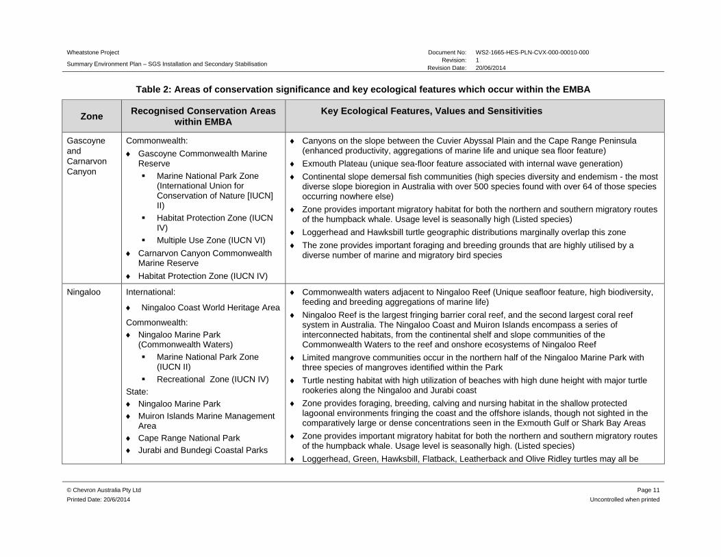
Table 2: Areas of conservation significance and key ecological features which occur within the EMBA
Zone Recognised Conservation Areas
within EMBA Key Ecological Features, Values and Sensitivities
Gascoyne and Carnarvon Canyon
Commonwealth:
Gascoyne Commonwealth Marine Reserve
Marine National Park Zone (International Union for Conservation of Nature [IUCN] II)
Habitat Protection Zone (IUCN IV)
Multiple Use Zone (IUCN VI)
Carnarvon Canyon Commonwealth Marine Reserve
Habitat Protection Zone (IUCN IV)
Canyons on the slope between the Cuvier Abyssal Plain and the Cape Range Peninsula (enhanced productivity, aggregations of marine life and unique sea floor feature)
Exmouth Plateau (unique sea-floor feature associated with internal wave generation)
Continental slope demersal fish communities (high species diversity and endemism - the most diverse slope bioregion in Australia with over 500 species found with over 64 of those species occurring nowhere else)
Zone provides important migratory habitat for both the northern and southern migratory routes of the humpback whale. Usage level is seasonally high (Listed species)
Loggerhead and Hawksbill turtle geographic distributions marginally overlap this zone
The zone provides important foraging and breeding grounds that are highly utilised by a diverse number of marine and migratory bird species
Ningaloo International:
Ningaloo Coast World Heritage Area
Commonwealth:
Ningaloo Marine Park (Commonwealth Waters)
Marine National Park Zone (IUCN II)
Recreational Zone (IUCN IV)
State:
Ningaloo Marine Park
Muiron Islands Marine Management Area
Cape Range National Park
Jurabi and Bundegi Coastal Parks
Commonwealth waters adjacent to Ningaloo Reef (Unique seafloor feature, high biodiversity, feeding and breeding aggregations of marine life)
Ningaloo Reef is the largest fringing barrier coral reef, and the second largest coral reef system in Australia. The Ningaloo Coast and Muiron Islands encompass a series of interconnected habitats, from the continental shelf and slope communities of the Commonwealth Waters to the reef and onshore ecosystems of Ningaloo Reef
Limited mangrove communities occur in the northern half of the Ningaloo Marine Park with three species of mangroves identified within the Park
Turtle nesting habitat with high utilization of beaches with high dune height with major turtle rookeries along the Ningaloo and Jurabi coast
Zone provides foraging, breeding, calving and nursing habitat in the shallow protected lagoonal environments fringing the coast and the offshore islands, though not sighted in the comparatively large or dense concentrations seen in the Exmouth Gulf or Shark Bay Areas
Zone provides important migratory habitat for both the northern and southern migratory routes of the humpback whale. Usage level is seasonally high. (Listed species)
Loggerhead, Green, Hawksbill, Flatback, Leatherback and Olive Ridley turtles may all be
Wheatstone Project Document No: WS2-1665-HES-PLN-CVX-000-00010-000
Summary Environment Plan – SGS Installation and Secondary Stabilisation Revision: 1
Revision Date: 20/06/2014
© Chevron Australia Pty Ltd Page 12
Printed Date: 20/6/2014 Uncontrolled when printed
Zone Recognised Conservation Areas
within EMBA Key Ecological Features, Values and Sensitivities
present in this zone
Whale sharks aggregate in the waters of the Ningaloo Marine Park, frequently close to the Ningaloo Reef front, both in the lagoon and outside it (Listed species)
The Muiron Islands are significant feeding areas for many species of seabirds and shorebirds, and are important nesting sites for the Wedge-tailed Shearwater. Migratory species that are most abundant in summer and autumn include the Wedge-tailed Shearwater and nine other migratory bird species that are protected under the China–Australia Migratory Bird Agreement (CAMBA) and Japan–Australia Migratory Bird Agreement (JAMBA)
Tourism and recreation is a major component of the local economy with Ningaloo Marine Park being a key tourist destination of local, state, national and international significance
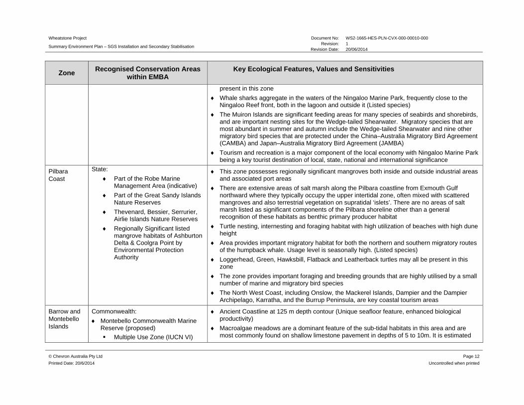
Pilbara Coast
State:
Part of the Robe Marine Management Area (indicative)
Part of the Great Sandy Islands Nature Reserves
Thevenard, Bessier, Serrurier, Airlie Islands Nature Reserves
Regionally Significant listed mangrove habitats of Ashburton Delta & Coolgra Point by Environmental Protection Authority
This zone possesses regionally significant mangroves both inside and outside industrial areas and associated port areas
There are extensive areas of salt marsh along the Pilbara coastline from Exmouth Gulf northward where they typically occupy the upper intertidal zone, often mixed with scattered mangroves and also terrestrial vegetation on supratidal ‘islets’. There are no areas of salt marsh listed as significant components of the Pilbara shoreline other than a general recognition of these habitats as benthic primary producer habitat
Turtle nesting, internesting and foraging habitat with high utilization of beaches with high dune height
Area provides important migratory habitat for both the northern and southern migratory routes of the humpback whale. Usage level is seasonally high. (Listed species)
Loggerhead, Green, Hawksbill, Flatback and Leatherback turtles may all be present in this zone
The zone provides important foraging and breeding grounds that are highly utilised by a small number of marine and migratory bird species
The North West Coast, including Onslow, the Mackerel Islands, Dampier and the Dampier Archipelago, Karratha, and the Burrup Peninsula, are key coastal tourism areas
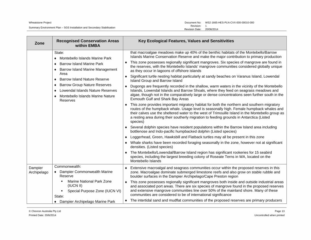
Barrow and Montebello Islands
Commonwealth:
Montebello Commonwealth Marine Reserve (proposed)
Multiple Use Zone (IUCN VI)
Ancient Coastline at 125 m depth contour (Unique seafloor feature, enhanced biological productivity)
Macroalgae meadows are a dominant feature of the sub-tidal habitats in this area and are most commonly found on shallow limestone pavement in depths of 5 to 10m. It is estimated
Wheatstone Project Document No: WS2-1665-HES-PLN-CVX-000-00010-000
Summary Environment Plan – SGS Installation and Secondary Stabilisation Revision: 1
Revision Date: 20/06/2014
© Chevron Australia Pty Ltd Page 13
Printed Date: 20/6/2014 Uncontrolled when printed
Zone Recognised Conservation Areas
within EMBA Key Ecological Features, Values and Sensitivities
State:
Montebello Islands Marine Park
Barrow Island Marine Park
Barrow Island Marine Management Area
Barrow Island Nature Reserve
Barrow Group Nature Reserves
Lowendal Islands Nature Reserves
Montebello Islands Marine Nature Reserves
that macroalgae meadows make up 40% of the benthic habitats of the Montebello/Barrow Islands Marine Conservation Reserve and make the major contribution to primary production
This zone possesses regionally significant mangroves. Six species of mangrove are found in the reserves, with the Montebello Islands’ mangrove communities considered globally unique as they occur in lagoons of offshore islands
Significant turtle nesting habitat particularly at sandy beaches on Varanus Island, Lowendal Island Group and Barrow Island
Dugongs are frequently recorded in the shallow, warm waters in the vicinity of the Montebello Islands, Lowendal Islands and Barrow Shoals, where they feed on seagrass meadows and algae, though not in the comparatively large or dense concentrations seen further south in the Exmouth Gulf and Shark Bay Areas
This zone provides important migratory habitat for both the northern and southern migratory routes of the humpback whale. Usage level is seasonally high. Female humpback whales and their calves use the sheltered water to the west of Trimouille Island in the Montebello group as a resting area during their southerly migration to feeding grounds in Antarctica (Listed species)
Several dolphin species have resident populations within the Barrow Island area including bottlenose and Indo-pacific humpbacked dolphin (Listed species)
Loggerhead, Green, Hawksbill and Flatback turtles may all be present in this zone
Whale sharks have been recorded foraging seasonally in the zone, however not at significant densities. (Listed species)
The Montebello/Lowendal/Barrow Island region has significant rookeries for 15 seabird species, including the largest breeding colony of Roseate Terns in WA, located on the Montebello Islands
Dampier Archipelago
Commonwealth:
Dampier Commonwealth Marine Reserve
Marine National Park Zone (IUCN II)
Special Purpose Zone (IUCN VI)
State:
Dampier Archipelago Marine Park
Extensive macroalgal and seagrass communities occur within the proposed reserves in this zone. Macroalgae dominate submerged limestone reefs and also grow on stable rubble and boulder surfaces in the Dampier Archipelago/Cape Preston region
This zone possesses regionally significant mangroves both inside and outside industrial areas and associated port areas. There are six species of mangrove found in the proposed reserves and extensive mangrove communities line over 50% of the mainland shore. Many of these communities are considered to be of international significance
The intertidal sand and mudflat communities of the proposed reserves are primary producers

Wheatstone Project Document No: WS2-1665-HES-PLN-CVX-000-00010-000
Summary Environment Plan – SGS Installation and Secondary Stabilisation Revision: 1
Revision Date: 20/06/2014
© Chevron Australia Pty Ltd Page 14
Printed Date: 20/6/2014 Uncontrolled when printed
Zone Recognised Conservation Areas
within EMBA Key Ecological Features, Values and Sensitivities
(proposed)
Dampier Archipelago Island Reserves
Part of the Greater Sandy Islands Nature Reserve
and have an abundance of invertebrate life, which provides a valuable food source for shorebirds
Low level numbers of dugongs have been recorded in the Dampier Archipelago / Cape Preston region. Particularly in the shallow, warm waters in bays and between islands, including at East Lewis Island, Cape Preston, Regnard Bay, Nickol Bay and west of Keast Island
The zone provides important migratory habitat for both the northern and southern migratory routes of the humpback whale. Usage level is seasonally high. Females occasionally give birth in the waters of the Dampier Archipelago, although the main calving area is further north. Adult humpback whales and their young also frequent the Archipelago on their southern migrations in early spring, and Mermaid Sound is a significant resting area for females with their calves (Listed species)
Loggerhead, Green, Hawksbill, Flatback and Leatherback turtles may all be present in this zone. Turtle nesting on beaches of the Dampier Archipelago, with particularly high nesting activities on Legendre and Huay Islands
The zone provides very important foraging and breeding habitat for a high diversity of birds, including a significant abundance of migratory and breeding seabirds. The small islands and islets such as Goodwyn Island, Keast Island and Nelson Rocks provide important undisturbed nesting and refuge sites and Keast Island provides one of the few nesting sites for pelicans in Western Australia
Offshore Not applicable - No marine or coastal conservation areas occur within this zone.
Glomar Shoals (Unique seafloor feature, high biodiversity and productivity, aggregations of marine life)
Ancient coastline at 125 m depth contour (Unique seafloor feature, enhanced biological productivity)
Continental slope demersal fish communities (Communities with high species diversity and endemism)
Canyons on the slope between the Cuvier Abyssal Plain and the Cape Range Peninsula (Unique sea floor feature, enhanced biological productivity, aggregations of marine life).
Exmouth Plateau (Unique sea-floor feature)
Zone provides important migratory habitat for both the northern and southern migratory routes of the humpback whale. Usage level is seasonally high (Listed species)
Loggerhead, Green, Hawksbill and Flatback turtles may all be present in this zone

Wheatstone Project Document No: WS2-1665-HES-PLN-CVX-000-00010-000
Summary Environment Plan – SGS Installation and Secondary Stabilisation Revision: 1
Revision Date: 20/06/2014
© Chevron Australia Pty Ltd Page 15
Printed Date: 20/6/2014 Uncontrolled when printed
Zone Recognised Conservation Areas
within EMBA Key Ecological Features, Values and Sensitivities
This zone overlaps a Biologically Important Area for Whaleshark foraging in deeper waters
The zone provides important foraging and breeding habitat that is highly utilised by various marine and migratory seabirds. Of particular note is the White-Tailed Tropic Bird which is only recorded in two locations in Western Australia
Argo- Rowley Terrace
Commonwealth:
Argo-Rowley Terrace Marine Reserve (proposed)
Marine National Park Zone (IUCN II)
Multiple Use Zone (IUCN VI)
Mermaid Reef Commonwealth Marine Reserve
IUCN 1a Strict Nature Reserve
State:
Rowley Shoals Marine Park
Canyons linking the Argo Abyssal Plain with the Scott Plateau (Unique seafloor, enhanced biological productivity, aggregations of marine life).
Mermaid Reef and the Commonwealth waters surrounding Rowley Shoals (enhanced productivity, aggregations of marine life, high biodiversity)
Continental slope demersal fish communities (Communities with high species diversity and endemism)
Intertidal coral reef communities are a major feature of the Rowley Shoals within this zone
Seagrasses and macroalgae are identified as key ecological values of the Rowley Shoals
Clerke and Imperieuse Reefs of the Rowley Shoals contain small calcareous sandy cays sourced from broken down coralline material and shell fragments, Bedwell Island and Cunningham Island, respectively. These islands are an important nesting site for the red-tailed tropic bird.
Zone provides migratory habitat for Pygmy Blue Whales. Usage level is seasonally high
Seasnakes are likely to be fairly common in the Rowley Shoals, particularly the olive seasnake
Loggerhead, Green and Hawksbill turtles may be present in this zone
Area provides important habitat for sharks, which are found in abundance around the Rowley Shoals relative to other areas in the region
A wide range of seabirds have been observed at the Rowley Shoals. Bedwell and Cunningham Islands are recognised as important resting places for northern migrants en route to and from Australia as large flocks of unidentified waders have been seen at the Rowley Shoals
Wheatstone Project Document No: WS2-1665-HES-PLN-CVX-000-000010-000 Summary Environment Plan – SGS Installation and Secondary Stabilisation
Revision: 1 Revision Date: 20/06/2014
© Chevron Australia Pty Ltd
Printed Date: 20/6/2014
4.0 MAJOR ENVIRONMENTAL HAZARDS AND CONTROLS
All aspects of the activity have been subjected to a comprehensive impact and risk assessment to understand the potential environmental risks associated with the activity and ensure risks are reduced to as low as reasonably practicable and are of an acceptable level. The risk assessment was undertaken in alignment with the processes outlined in Australian Standard/New Zealand Standard (AS/NZS) ISO 31000:2009 Risk Management and HB 203:2012 Managing Environment-Related Risk, using the Chevron Integrated Risk Prioritization Matrix.
The following environmental aspects were categorised for use in the risk assessment for this activity:
Physical presence
Benthic disturbance
Light emissions
Noise
Atmospheric emissions
Introduced marine pests (IMPs)
Hazardous and non-hazardous solid waste
Hazardous and non-hazardous liquid waste.
Hydrocarbon spills and leaks.
To ensure the potential environmental impacts identified through the risk assessment are managed appropriately, Chevron has developed a range of performance standards (controls) that will be implemented throughout the course of SGS installation and secondary stabilisation. A summary of the major environmental hazards and controls are detailed in Table 2.
Wheatstone Project Document No: WS2-0000-HES-PLN-CVX-000-00010-000
Summary Environment Plan – SGS Installation and Secondary Stabilisation Revision: 1
Revision Date: 20/06/2014
© Chevron Australia Pty Ltd Page 17
Printed Date: 20/6/2014 Uncontrolled when printed
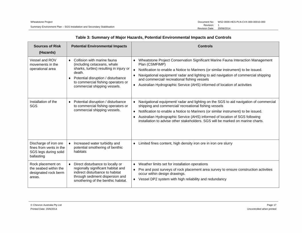
Table 3: Summary of Major Hazards, Potential Environmental Impacts and Controls
Sources of Risk
(Hazards)
Potential Environmental Impacts Controls
Vessel and ROV movements in the operational area
Collision with marine fauna (including cetaceans, whale sharks, turtles) resulting in injury or death.
Potential disruption / disturbance to commercial fishing operators or commercial shipping vessels.
Wheatstone Project Conservation Significant Marine Fauna Interaction Management Plan (CSMFIMP)
Notification to enable a Notice to Mariners (or similar instrument) to be issued.
Navigational equipment/ radar and lighting to aid navigation of commercial shipping and commercial/ recreational fishing vessels
Australian Hydrographic Service (AHS) informed of location of activities
Installation of the SGS
Potential disruption / disturbance to commercial fishing operators or commercial shipping vessels.
Navigational equipment/ radar and lighting on the SGS to aid navigation of commercial shipping and commercial/ recreational fishing vessels
Notification to enable a Notice to Mariners (or similar instrument) to be issued.
Australian Hydrographic Service (AHS) informed of location of SGS following installation to advise other stakeholders. SGS will be marked on marine charts.
Discharge of iron ore fines from vents in the SGS legs during solid ballasting
Increased water turbidity and potential smothering of benthic habitats
Limited fines content, high density iron ore in iron ore slurry
Rock placement on the seabed within the designated rock berm areas.
Direct disturbance to locally or regionally significant habitat and indirect disturbance to habitat through sediment dispersion and smothering of the benthic habitat.
Weather limits set for installation operations
Pre and post surveys of rock placement area survey to ensure construction activities occur within design drawings.
Vessel DP2 system with high reliability and redundancy

Wheatstone Project Document No: WS2-0000-HES-PLN-CVX-000-00010-000
Summary Environment Plan – SGS Installation and Secondary Stabilisation Revision: 1
Revision Date: 20/06/2014
© Chevron Australia Pty Ltd Page 18
Printed Date: 20/6/2014 Uncontrolled when printed
Sources of Risk
(Hazards)
Potential Environmental Impacts Controls
Unplanned rock placement on the seabed outside the designated rock berm areas.
Direct disturbance to locally or regionally significant habitat and indirect disturbance to habitat through sediment dispersion and smothering of the benthic habitat.
As above
Dropped object on seabed due to cable or lifting point failure
Temporary loss of localised of localised benthic habitat
Lifting procedures including recovery of dropped objects if required
Weather limits set for installation operations
Loss of iron ore ballast slurry during transfer due to failure of DP system or adverse weather conditions
Smothering of widespread benthic habitat resulting in impacts to sessile fauna
Vessel DP2 system with high reliability and redundancy
Manual shutdown of hoses
Weather limits set for installation operations
Vessel thrusters / engine operation / machinery / transponder from survey/ rock placement.
Physiological damage to marine fauna (physical and perceptual).
Disruption to behaviour patterns of marine fauna (including indirect impacts such as displacement or injury of prey species).
Maintenance of vessel engines, DP2 system and transponder
CSMFIMP
Ballast water exchange potentially harbouring IMP in the operational area
Introduction of IMP to the operational area.
All high risk non trading vessels will have Department of Agriculture clearance and ballast water exchange in accordance with Australian Ballast Water Requirements.
Wheatstone Introduced Marine Pest Risk Assessment Procedure (IMPRAP)
Vessels with biofouling potentially harbouring IMP in the operational area.
Introduction of IMP to the operational area.
All required vessels will have current anti-fouling certification.
Wheatstone IMPRAP
Accidental loss to the Temporary and localised reduction Appropriate segregation and containment of wastes, induction training in accordance
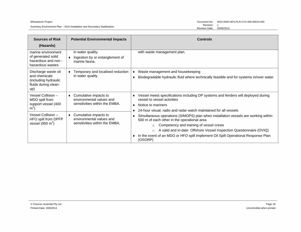
Wheatstone Project Document No: WS2-0000-HES-PLN-CVX-000-00010-000
Summary Environment Plan – SGS Installation and Secondary Stabilisation Revision: 1
Revision Date: 20/06/2014
© Chevron Australia Pty Ltd Page 19
Printed Date: 20/6/2014 Uncontrolled when printed
Sources of Risk
(Hazards)
Potential Environmental Impacts Controls
marine environment of generated solid hazardous and non -hazardous wastes
in water quality.
Ingestion by or entanglement of marine fauna.
with waste management plan.
Discharge waste oil and chemicals (including hydraulic fluids during clean-up)
Temporary and localised reduction in water quality
Waste management and housekeeping
Biodegradable hydraulic fluid where technically feasible and for systems in/over water
Vessel Collision – MDO spill from support vessel (400 m3)
Cumulative impacts to environmental values and sensitivities within the EMBA.
Vessel meets specifications including DP systems and fenders will deployed during vessel to vessel activities
Notice to mariners
24-hour visual, radio and radar watch maintained for all vessels
Simultaneous operations (SIMOPS) plan when installation vessels are working within 500 m of each other in the operational area
o Competency and training of vessel crews
o A valid and in-date Offshore Vessel Inspection Questionnaire (OVIQ)
In the event of an MDO or HFO spill Implement Oil Spill Operational Response Plan (OSORP)
Vessel Collision – HFO spill from DPFP vessel (950 m3)
Cumulative impacts to environmental values and sensitivities within the EMBA.
Wheatstone Project Document No: WS2-1665-HES-PLN-CVX-000-00010-000 Summary Environment Plan – SGS Installation and Secondary Stabilisation
Revision: 1 Revision Date: 20/06/2014
© Chevron Australia Pty Ltd Page 20
Printed Date: 20/6/2014 Uncontrolled when printed
5.0 MANAGEMENT APPROACH
The implementation strategy identifies the systems, practices and procedures to be used to ensure the environmental impacts and risks of the activities are reduced to ALARP and are acceptable, and the environmental performance objectives and standards are met. The implementation strategy is split between planned operational activities and unplanned event response, enabling roles and responsibilities to be clearly defined and to provide a clear chain of command for both.
The implementation strategy is to be enacted in accordance with Chevron Australia’s Operational Excellence Management System. Chevron’s Operational Excellence Management System is aligned to ISO 14001:2004 and key components of the management system are described in the subsections below.
5.1 Roles and Responsibilities
Accountabilities and responsibilities are defined for personnel involved in the projects implementation for both planned activities and emergency conditions.
5.2 Training and Competency
All personnel are required to attend environmental inductions and training relevant to their role for the activities. Training and induction programs facilitate the understanding personnel have of their environmental responsibilities, and increase their awareness of the management and protection measures required to reduce potential impacts on the environment. In addition to project training, personnel will also receive spill response training.
5.3 Monitoring and Reporting
The implementation strategy outlines the requirements for the following:
marine fauna observations oil spill monitoring plan emissions and discharges, and routine external reporting and non-routine reporting (including internal incident
reporting and investigations and external incident and near misses reporting).
5.4 Compliance assurance
A multi-tiered environmental compliance assurance program will be implemented for the duration of the activities described in the detailed Plan, including tools, processes and procedures to deliver and verify compliance with the EP. Assurance activities will include both Chevron-led and contractor-led audits and inspections. Chevron-led audits and inspections will be undertaken as required and in accordance with Chevron’s ABU Compliance Assurance Process and the Health, Environment and Safety Audit Schedule for the Project.
5.5 Documentation and Records
Chevron Australia’s ABU Operational Excellence Management System (OEMS) has dedicated information management tools and processes to ensure critical information is developed, accessible and maintained by the workforce. Wheatstone documentation shall be managed in accordance with this Process, and specifically via the Project’s Document Management System. Accordingly, all documentation and records demonstrating compliance against environmental performance objectives and standards will be effectively maintained and retained for the life of the Project and not less than five years.
Wheatstone Project Document No: WS2-1665-HES-PLN-CVX-000-00010-000 Summary Environment Plan – SGS Installation and Secondary Stabilisation
Revision: 1 Revision Date: 20/06/2014
© Chevron Australia Pty Ltd Page 21
Printed Date: 20/6/2014 Uncontrolled when printed
5.6 Environment Plan Review
Chevron’s Management of Change process will be followed to document and assess the impact of any changes to the activities described in the EP. These changes will be addressed to determine if there is potential for any new or increased environmental impact or risk not already provided for in the EP. Where required the EP will be re-submitted to NOPSEMA for approval in accordance with Regulation 17 of the Offshore Petroleum and Greenhouse Gas Storage (Environment) Regulations 2009 (OPGGS(E)R).
Wheatstone Project Document No: WS2-1665-HES-PLN-CVX-000-00010-000 Summary Environment Plan – SGS Installation and Secondary Stabilisation
Revision: 1 Revision Date: 20/06/2014
© Chevron Australia Pty Ltd Page 22
Printed Date: 20/6/2014 Uncontrolled when printed
6.0 CONSULTATION
Chevron prepared a Stakeholder Consultation Plan specific for this activity. The Stakeholder Consultation Plan describes:
stakeholder identification and analysis communication engagement plan, comprising the level and trigger of engagement,
type of engagement, and frequency stakeholder engagement log, including any issues raised and Chevron responses full text of consultation.
6.1 Stakeholder Identification and Analysis
Relevant stakeholders have been identified through a stakeholder analysis process to ensure persons or organisations that may potentially be affected by the overall Wheatstone Platform and associated activities including SGS installation and secondary stabilisation work have been consulted. Stakeholders were identified by reviewing:
social / commercial receptors within the EMBA historical consultation undertaken for Chevron applicable legislation to identify regulatory agencies and Relevant agencies or organizations which may be involved in the event of a spill.
6.2 Communication Engagement Plan
Once the stakeholder analysis was completed, a Communication Engagement Plan was developed to determine the following, for each stakeholder:
the level of engagement required the type of engagement required when engagement would be undertaken and the frequency of communication.
The Communication Engagement Plan covers both initial and ongoing stakeholder engagement for both planned activities and emergency conditions. Chevron will maintain communications with identified stakeholders as required ensuring they are informed of any aspects of the SGS installation and secondary stabilisation activity that may potentially affect their respective interests within the area.

Wheatstone Project Document No: WS2-1665-HES-PLN-CVX-000-00010-000 Summary Environment Plan – SGS Installation and Secondary Stabilisation
Revision: 1 Revision Date: 20/06/2014
© Chevron Australia Pty Ltd Page 23
Printed Date: 20/6/2014 Uncontrolled when printed
7.0 CONTACT DETAILS
Further information associated with the proposed activities may be obtained from:
Andy Turner
Wheatstone Upstream HES Manager
Phone: +61 8 9216 4952
Fax: +61 8 9413 6885
Email: [email protected]