What’s Changed? - National Weather Service€¦ · New York, NY Weather Forecast Office...
9
New York, NY Weather Forecast Office Presentation Created 1/3/2018 7:19 AM Follow us on Twitter Follow us on Facebook Heavy Snow/Wind Tonight into Thursday Decision Support Briefing #2 As of: 5am January 3, 2018 What’s Changed? • Suffolk County and much of S CT upgraded to Winter Storm Warning • Winter Storm Watch Issued for NYC metro, Nassau County, and SW CT • Gale and Storm warnings issued for nearshore waters
Transcript of What’s Changed? - National Weather Service€¦ · New York, NY Weather Forecast Office...

New York, NY Weather Forecast Office Presentation Created
1/3/2018 7:19 AM Follow us on Twitter Follow us on Facebook
Heavy
Snow/Wind
Tonight into
Thursday
Decision Support Briefing #2
As of: 5am January 3, 2018
What’s Changed?
• Suffolk County and much of S CT upgraded to Winter
Storm Warning
• Winter Storm Watch Issued for NYC metro, Nassau
County, and SW CT
• Gale and Storm warnings issued for nearshore waters

New York, NY Weather Forecast Office Presentation Created
1/3/2018 7:19 AM Follow us on Twitter Follow us on Facebook
Main Points
Hazard Impacts Location Timing
Snow
• 6-10” likely, with excess of 1’
possible.
• Snowfall rates 1 to 2” / hr likely
• Blizzard conditions possible
• Difficult travel
Suffolk, New London,
New Haven and
Middlesex Counties Late Tonight through
Thursday
• 3-6” of snow, with excess of 6”
possible
• Snowfall rates of 1”/hr possible
• Significant travel delays likely
NYC, NE NJ, W LI, SW
CT, and Much of the
Lower Hudson Valley
Late Tonight through
Thursday
Wind
• 25 - 40 MPH wind gusts
----------------------------------------------------
• 40 - 50 MPH wind gusts
----------------------------------------------------
• Blowing and drifting snow
• Potential for power outages
Entire Tri-State Area
----------------------------------
Long Island / SE CT
---------------------------------
Late Thu Morning into
Thursday Night
Cold • Wind Chills of -15 to -25 F
• Frostbite and Hypothermia threat
from prolonged exposure
Entire Tri-State,
Lowest wind chills
interior areas
Late Thu night / Fri AM
Late Fri night / Sat AM
Surge
• Minor to Locally Moderate Coastal
Flooding
• Locally 1 to 2 ft of inundation
along Western Great South Bay
Western LI Sound,
Southern and Eastern
Bays of Long Island &
NYC
Around the times of high
tide Thursday morning

New York, NY Weather Forecast Office Presentation Created
1/3/2018 7:19 AM Follow us on Twitter Follow us on Facebook
NYC Metro, Lower Hudson Valley and NE NJ
Remainder Long
Strong Winds: Entire Tri-State
Storm Surge: W LI Sound/NYC&W LI Back Bays
Suffolk County and most of CT
None Limited Elevated Significant Extreme
Summary of Greatest Impacts
None Limited Elevated Significant Extreme
None Limited Elevated Significant Extreme
None Limited Elevated Significant Extreme
Note: Hazard impact level definitions can be found on our Graphical Hazardous Weather Outlook http://www.weather.gov/okx/ehwo
Bitter to Dangerous Cold: Entire Tri-State
None Limited Elevated Significant Extreme

New York, NY Weather Forecast Office Presentation Created
1/3/2018 7:19 AM Follow us on Twitter Follow us on Facebook
Probabilistic Snowfall Forecasts
New York, NY Weather Forecast Office Presentation Created
1/3/2018 7:19 AM Follow us on Twitter Follow us on Facebook
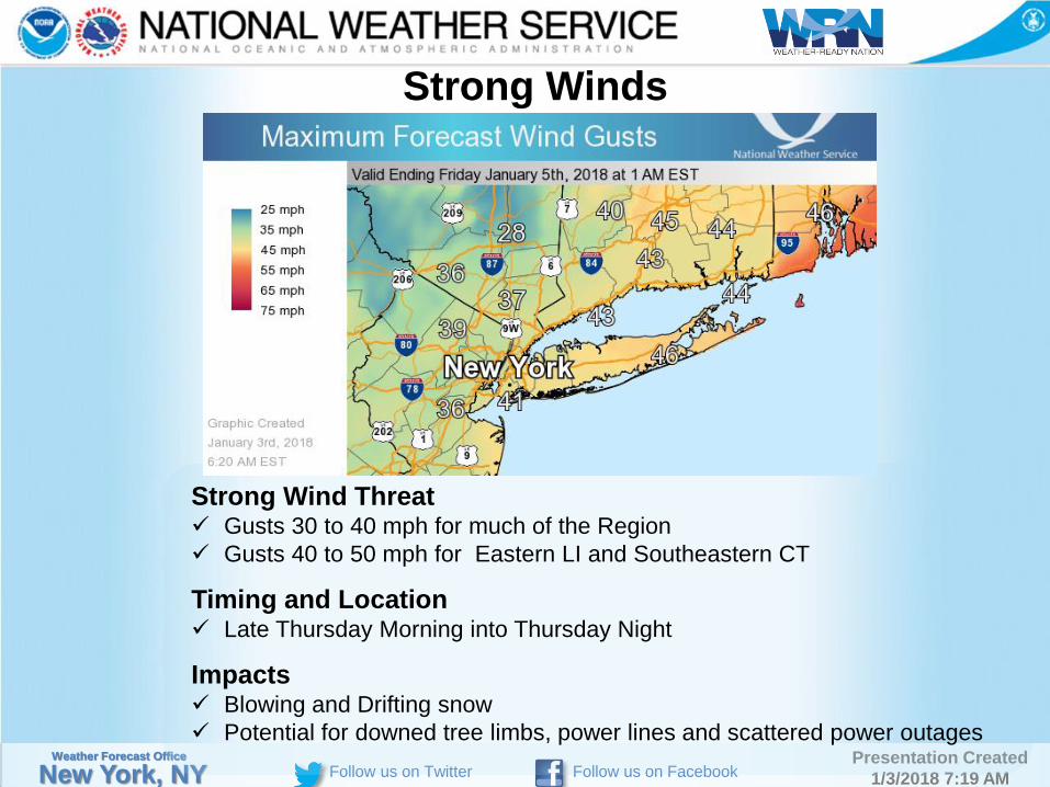
Strong Winds
Strong Wind Threat Gusts 30 to 40 mph for much of the Region
Gusts 40 to 50 mph for Eastern LI and Southeastern CT
Timing and Location Late Thursday Morning into Thursday Night
Impacts Blowing and Drifting snow
Potential for downed tree limbs, power lines and scattered power outages

New York, NY Weather Forecast Office Presentation Created
1/3/2018 7:19 AM Follow us on Twitter Follow us on Facebook
Dangerous Cold
Wind Chills -5 to -15 F Late Thursday Night into Friday Morning
-15 to -25 F Late Friday Night into Saturday Morning
Impacts Frostbite and Hypothermia threat from prolonged exposure
New York, NY Weather Forecast Office Presentation Created
1/3/2018 7:19 AM Follow us on Twitter Follow us on Facebook
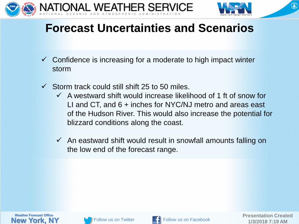
Forecast Uncertainties and Scenarios
Confidence is increasing for a moderate to high impact winter
storm
Storm track could still shift 25 to 50 miles.
A westward shift would increase likelihood of 1 ft of snow for
LI and CT, and 6 + inches for NYC/NJ metro and areas east
of the Hudson River. This would also increase the potential for
blizzard conditions along the coast.
An eastward shift would result in snowfall amounts falling on
the low end of the forecast range.
New York, NY Weather Forecast Office Presentation Created
1/3/2018 7:19 AM Follow us on Twitter Follow us on Facebook
Event Summary
6 to 10 inches of snow likely across Suffolk County and most of
Southern CT, with potential for 1 ft or more, late tonight through
Thursday.
Snowfall rates of 1 to 2 “/ hr likely
Blizzard Conditions possible
3 to 6 inches of snow likely for NYC metro, SW CT, and Nassau
County, with potential for 6” or more, late Tonight through Thursday
30 to 50 mph wind gusts late Thursday morning into Thursday Night
may down some tree limbs and powerlines, as well as cause blowing
and drifting of snow.
Gale to Storm Conditions on the nearshore waters Thursday through
Friday
Dangerously cold wind chills likely early Friday Morning and early
Saturday morning
New York, NY Weather Forecast Office Presentation Created
1/3/2018 7:19 AM Follow us on Twitter Follow us on Facebook
Web:
http://www.weather.gov/okx/
Phone (public):
631-924-0517
E-mail:
Facebook:
http://www.facebook.com/NWSNewYorkNY
Twitter:
http://www.twitter.com/NWSNewYorkNY
YouTube:
https://www.youtube.com/user/NWSNewYorkNY
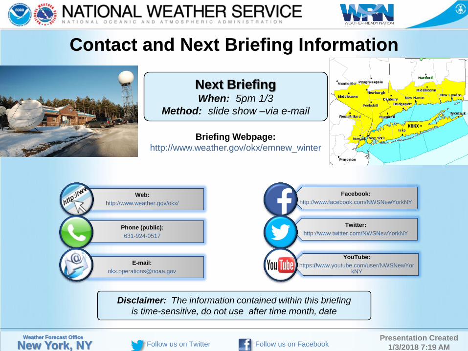
Contact and Next Briefing Information
Briefing Webpage:
http://www.weather.gov/okx/emnew_winter
Insert picture of office Insert image of
briefing domain
Next Briefing When: 5pm 1/3
Method: slide show –via e-mail
Disclaimer: The information contained within this briefing
is time-sensitive, do not use after time month, date