What is the topic of this pie chart?
16
Lesson: Map, Chart, and Graph Skills Lesson Topic: Charts and Graphs What is the topic of this pie chart? the specific dates each country launched spacecraft to space between 1957 and 1969 the number of spacecraft each country launched to space between 1957 and 1969 the change in the number of spacecraft launched to space through the years 1957 and 1969 the amount of money each country spent to launch spacecraft to space between 1957 and 1969 Question 1: Based on the information in the pie chart, which country sent the first spacecraft to space? Question 2:
Transcript of What is the topic of this pie chart?
Lesson: Map, Chart, and Graph Skills
Lesson Topic: Charts and Graphs
What is the topic of this pie chart?
the specific dates each country launched spacecraft to space between 1957 and 1969
the number of spacecraft each country launched to space between 1957 and 1969
the change in the number of spacecraft launched to space through the years 1957 and 1969
the amount of money each country spent to launch spacecraft to space between 1957 and 1969
Question 1:
Based on the information in the pie chart, which country sent the first spacecraft to space?
Question 2:

France
the United States
the Soviet Union
Great Britain
There is not enough information in the pie chart to answer the question.
Why might this pie chart include a slice for “other” expenses instead of having individual slices for each expense?
Question 3:
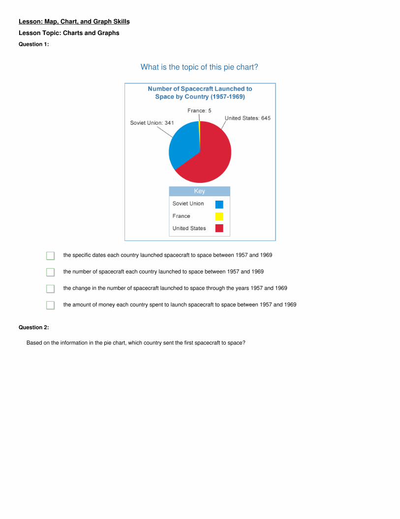
Describe the general trend of US imports, or things purchased from other countries, during the time period shown on the graph. Then, use the
bar graph to describe the trend of exports, or things sold to other countries.
Question 4:

The percentage of Americans who __________ increased the most during this sixty-year period. One trend seen in the graph is that the
percentage of Protestant Americans is generally __________.
are Protestant; decreasing
do not practice a religion; increasing
do not practice a religion; decreasing
are Jewish; decreasing
are Jewish; increasing
are Protestant; increasing
Question 5:

Lesson Topic: Map and Globe Skills
Where are the places shown on the inset map located?
They are located in the eastern part of the country.
They are located outside of the larger map.
They are located in South America.
They are located in the southern part of the country.
Question 1:
Which cities are within 480 kilometers of Montgomery?
(Hint: It may help to use a piece of paper to measure the length of the scale. You can then move the paper around on the map to estimate
distances.)
Nashville
Columbia
Question 2:

Jackson
Little Rock
Atlanta
Tallahassee
Use the correct map to determine the distance between Denver, Colorado, and Topeka, Kansas.
400 kilometers
600 kilometers
800 kilometers
1,200 kilometers
Question 3:
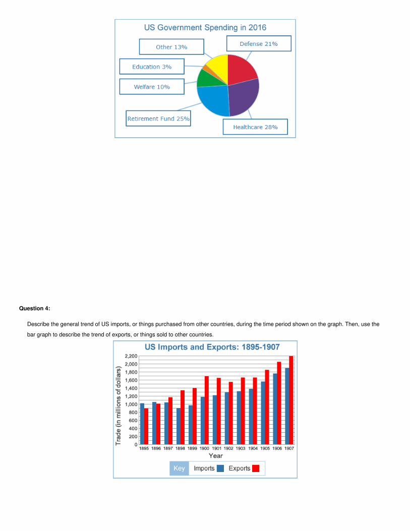
Select the list that shows the correct coordinates for the cities on the map.
Question 4:
Kimberly is in B-4; Port Elizabeth is in D-4; Cape town is in C-5.
Kimberly is in A-5; Port Elizabeth is in C-4; Cape town is in B-2.
Kimberly is in B-3; Port Elizabeth is in D-3; Cape town is in D-2.
Kimberly is in C-4; Port Elizabeth is in D-4; Cape town is in D-2.
Which continents are located fully in the Western Hemisphere?
Asia
North America
Africa
Australia
Question 5:

Europe
South America

Lesson Topic: Types of Maps, Part 1
A border is a political boundary that separates different areas. Political maps use borders to show the areas that different governments control.
Which of the following statements is most likely true?
A political map shows the laws that governments create.
A political map shows where governments can create and enforce laws.
A political map shows the different types of governments in a region.
A political map shows the populations of different governmental regions.
Question 1:
Which states does the Cumberland Plateau stretch across?
Georgia
Alabama
North Carolina
Ohio
Tennessee
Kentucky
South Carolina
Question 2:
Name two situations when someone might want to use a physical map.
Question 3:

Which statement is true?
Points A, B, and C all have different elevations.
Points A, B, and C all have the same elevations.
Points A and B have the same elevation, while point C has a different elevation.
Points B and C have the same elevation, while point A has a different elevation.
Question 4:
Question 5:

Which of the following shows the points in order from highest elevation to lowest elevation?
D, C, A, B
C, D, A, B
A, B, C, D
D, A, B, C

Lesson Topic: Types of Maps, Part 2
This cultural map shows the religions most commonly practiced in different parts of Indonesia. The main religion practiced on the island of
Sumatra is __________, and the main religion practiced on Java is __________.
Hinduism; Catholicism
Protestantism, Modernist Islam
Traditional Islam; Buddhism
Modernist Islam; Traditional Islam
Question 1:
Question 2:
What does this map suggest about South American culture?
It was influenced by people from Asia.
It was influenced by people native to South America.
It was influenced by people from Europe.
It has not been influenced by any other cultures.
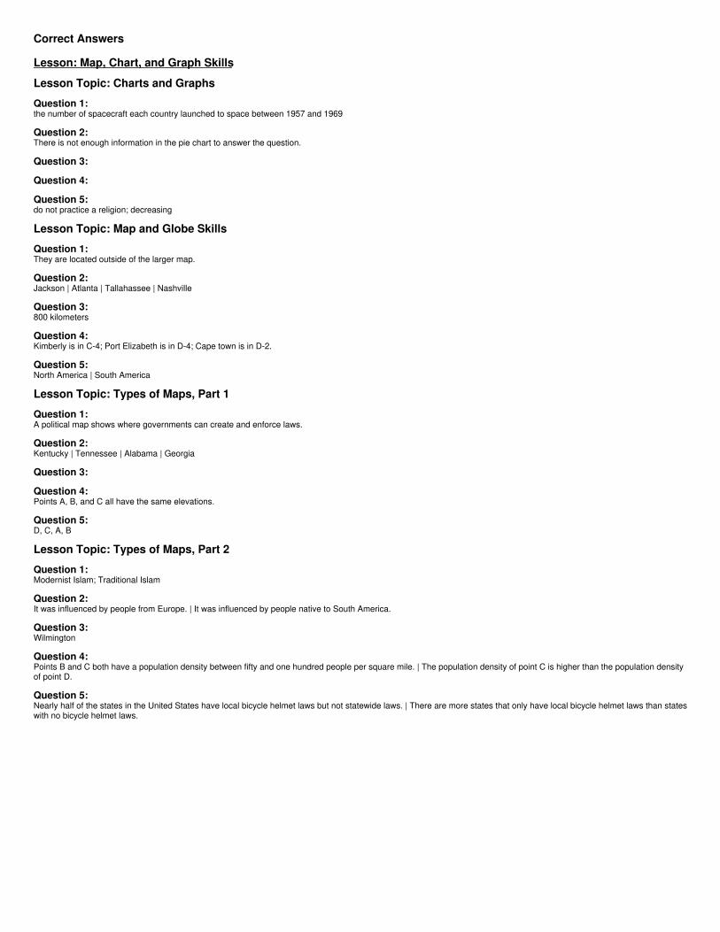
Lindsey owns a grocery store in the town of Bowers, which is in Kent County. She hopes to relocate to an area that is more densely populated
so she will have more customers. Which area would be the best place for Lindsey to relocate her store?
Townsend
Bridgeville
Wilmington
Leipsic
Question 3:
Question 4:

Which statements are NOT true?
The population density of point C is higher than the population density of point D.
Point B has the highest population density.
Points B and C both have a population density between fifty and one hundred people per square mile.
Point A has the lowest population density.
Question 5:

Based on the map, which of the following statements are true?
Most states in the Northeast have statewide bicycle helmet laws.
Most states in the United States have statewide bicycle helmet laws.
There are more states that only have local bicycle helmet laws than states with no bicycle helmet laws.
Nearly half of the states in the United States have local bicycle helmet laws but not statewide laws.
Correct Answers
Lesson: Map, Chart, and Graph Skills
Lesson Topic: Charts and Graphs
Question 1:the number of spacecraft each country launched to space between 1957 and 1969
Question 2:There is not enough information in the pie chart to answer the question.
Question 3:
Question 4:
Question 5:do not practice a religion; decreasing
Lesson Topic: Map and Globe Skills
Question 1:They are located outside of the larger map.
Question 2:Jackson | Atlanta | Tallahassee | Nashville
Question 3:800 kilometers
Question 4:Kimberly is in C-4; Port Elizabeth is in D-4; Cape town is in D-2.
Question 5:North America | South America
Lesson Topic: Types of Maps, Part 1
Question 1:A political map shows where governments can create and enforce laws.
Question 2:Kentucky | Tennessee | Alabama | Georgia
Question 3:
Question 4:Points A, B, and C all have the same elevations.
Question 5:D, C, A, B
Lesson Topic: Types of Maps, Part 2
Question 1:Modernist Islam; Traditional Islam
Question 2:It was influenced by people from Europe. | It was influenced by people native to South America.
Question 3:Wilmington
Question 4:Points B and C both have a population density between fifty and one hundred people per square mile. | The population density of point C is higher than the population densityof point D.
Question 5:Nearly half of the states in the United States have local bicycle helmet laws but not statewide laws. | There are more states that only have local bicycle helmet laws than stateswith no bicycle helmet laws.


