What Is ArcGIS whitepaper - dusk.geo.orst.edu
56
GIS by ESRI ™ What is ArcGIS ™ ?
Transcript of What Is ArcGIS whitepaper - dusk.geo.orst.edu
GIS by ESRI ™
What is ArcGIS™ ?

���������� ��� �������������������������������������������� ���!��
"������� ����!��������������!# �������$!�#������������������"���%��&������!��#�������������!������� ��%������� ����������� !������� ������ ��� !����������'���� �� ���%��& ��(� ������#!�������� ��� ����� ��� ��(���� ����)���!����!�� �!����!��) ��!�#��������!��������� ��!������)��(��������� ������������������������ )�$!�����$���������� �����%�����(�����������*#������#��(�����������+�����!�,������)����)-. '�%/��&����)��������)��0�-1-2.� )����
"������� ����!��������������!# �����#(3�!�!�����%���#���!��
���������������� ������ � ���� ����������%���)��!# ������)���4������������������#�������#(3�!����� �����5�!��������� ����������������������6����� ���!*#���������������"���"�745�,�"�7��68"���� ��� # )#��)�#���!����)�����!���#�� (� ������ 6����� �� �� �#(3�! � �����!���� �� �� ���� �� 9��:;����12�<�������� �) ��) ��� ���=>�'?�0.1@A9��:;����12�0=>�'�0.1@���4��9��:������4������=�� ��!���"�!���!��7��4�� �#�����%���@A���79���:�;����121 �;='BC�00;@="�!���!��7��@���4��79���:��1�1� �=�� �#�����%���@)�������!�(��������!��4,��#��!#���������)-. '�%/��&����)��������)��0�-1-2.� )����
����)��!C��%),��B(3�!�)��!�,�)���������(������������ ��&�������)�������������������������!���������!�#�����A������������������������#�������� #������!,��)��!����)��!�7�)��!�����)��!6��)��!������)��!���)��!"���(�$)��!�����)�,5)��!�!���)��!B(3�!�)��!"�')��!6���) -7������) ����,��)��!�$������)����#�)��!���)��!���)��!�!��)��!������)6��(�����)����!�,������������������������������ ��&����6��������'�%��&)%%%������!� )��!������������!� )%%%������������%��&�!� )�����6��������'�%��&������������!� ��&��
B���!� �������������#!� �������������������� ��&���������������� ��&������������!������� ��&�%�����
Attribution.p65 04/25/2002, 10:44 AM1
iii
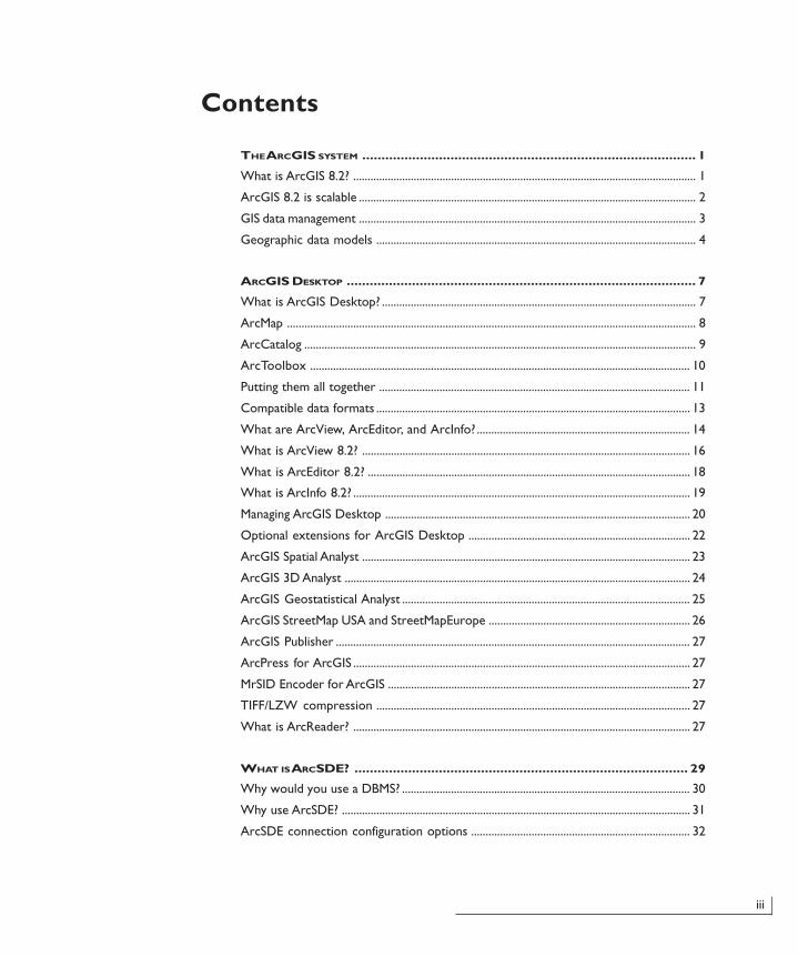
Contents
THE ARCGIS SYSTEM ....................................................................................... 1
What is ArcGIS 8.2? ....................................................................................................................... 1
ArcGIS 8.2 is scalable ..................................................................................................................... 2
GIS data management ..................................................................................................................... 3
Geographic data models ............................................................................................................... 4
ARCGIS DESKTOP ........................................................................................... 7
What is ArcGIS Desktop? ............................................................................................................. 7
ArcMap .............................................................................................................................................. 8
ArcCatalog ........................................................................................................................................ 9
ArcToolbox .................................................................................................................................... 10
Putting them all together ............................................................................................................ 11
Compatible data formats ............................................................................................................. 13
What are ArcView, ArcEditor, and ArcInfo? .......................................................................... 14
What is ArcView 8.2? .................................................................................................................. 16
What is ArcEditor 8.2? ................................................................................................................ 18
What is ArcInfo 8.2? ..................................................................................................................... 19
Managing ArcGIS Desktop .......................................................................................................... 20
Optional extensions for ArcGIS Desktop ............................................................................. 22
ArcGIS Spatial Analyst .................................................................................................................. 23
ArcGIS 3D Analyst ........................................................................................................................ 24
ArcGIS Geostatistical Analyst .................................................................................................... 25
ArcGIS StreetMap USA and StreetMapEurope ...................................................................... 26
ArcGIS Publisher ........................................................................................................................... 27
ArcPress for ArcGIS ..................................................................................................................... 27
MrSID Encoder for ArcGIS ......................................................................................................... 27
TIFF/LZW compression ............................................................................................................. 27
What is ArcReader? ..................................................................................................................... 27
WHAT IS ARCSDE? ....................................................................................... 29
Why would you use a DBMS? .................................................................................................... 30
Why use ArcSDE? ......................................................................................................................... 31
ArcSDE connection configuration options ............................................................................ 32
TOC.p65 04/25/2002, 10:44 AM3
What is ArcGIS? • iv
WHAT IS ARCIMS? ........................................................................................ 33
Why use ArcIMS? .......................................................................................................................... 33
The ArcIMS architecture ............................................................................................................. 34
ArcIMS services ............................................................................................................................. 35
ArcXML: the common language for ArcIMS ........................................................................... 37
Extending your ArcIMS application ........................................................................................... 37
Authoring and managing an ArcIMS Web site ......................................................................... 38
ArcIMS clients ................................................................................................................................ 39
NOTES TO EXISTING ARCVIEW GIS USERS ........................................................ 45
Comparing ArcView GIS 3 to ArcView 8.2 ............................................................................ 45
Organization of ArcView GIS 3 ................................................................................................. 46
Organization of ArcView 8.2 ..................................................................................................... 47
Comparison of key concepts ..................................................................................................... 48
ArcView extensions at 8.2 ......................................................................................................... 49
Importing ArcView GIS 3 projects and legends into ArcMap ............................................ 50
New features and functionality beyond ArcView GIS 3 ...................................................... 51
TOC.p65 04/25/2002, 10:44 AM4
The ArcGIS system • 1
THE ARCGIS SYSTEM
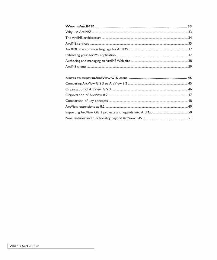
What is ArcGIS 8.2?The ArcGIS™ system is an integrated geographicinformation system (GIS) consisting of three keyparts:
• ArcGIS Desktop software, an integrated suite ofadvanced GIS applications
• ArcSDE™ gateway, an interface for managinggeodatabases in a database management system(DBMS)
• ArcIMS® software, Internet-based GIS for distributingdata and services
ArcGIS provides a framework for implementing GIS for asingle user or for many users. ArcGIS can be extendedwith additional software such as ArcPad™ forWindows® CE devices.
This short book is intended to help you understandthe various parts of ArcGIS and the role each partplays in a GIS. Whether you are new to ESRI® software orare already an experienced user, this book will help you tobegin to learn and understand the various parts of thisnew software system.
HTMLViewer
JavaViewer
ArcGIS System
Files
ArcIMS Server
ArcGIS Desktop ArcIMS
ArcSDE
ArcSDE Gateway
Database
ArcView ArcEditor ArcInfoFreeArcReader
MapObjects—Java Standard
Edition
Ch01.p65 04/25/2002, 11:04 AM1
2 • What is ArcGIS?
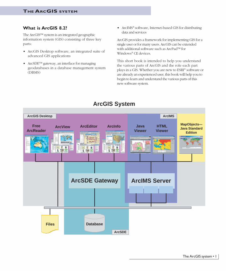
ArcGIS 8.2 is scalableArcGIS is a system of parts that can be deployed on asingle desktop or distributed on a heterogeneous computernetwork of workstations and servers. Users can deploy
various parts of this system to implement a GIS of anysize—from a single-user system to workgroups anddepartments, for large enterprises, and for societal GISsystems.
Ch01.p65 04/25/2002, 11:04 AM2

The ArcGIS system • 3
GIS data managementArcGIS uses intelligent GIS data models forrepresenting geography and provides all the tools
necessary for creating and working with the geographicdata. This includes tools for all GIS tasks: editing and dataautomation, mapping and map-based tasks, datamanagement, geographic analysis, metatdata management,and deploying data and applications on the Internet.
Geoprocessing
Mapping and cartography
Metadata management
Editing
Ch01.p65 04/25/2002, 11:04 AM3

4 • What is ArcGIS?
Geographic data modelsArcGIS has a high-level geographic data model forrepresenting spatial information as features, rasters,and other spatial data types. ArcGIS supports animplementation of the data model for both file systemsand DBMSs. The file-based models include GIS datasets,such as coverages, shapefiles, grids, images, andtriangulated irregular networks (TINs). The geodatabasemodel manages the same types of geographic informationin a DBMS, providing many of the data managementbenefits offered by a DBMS.
Both the file-based data models and the DBMS-based geodatabase model define a generic model forgeographic information. This generic model can beused to define and work with a wide variety ofdifferent user- or application-specific models. Bydefining and implementing the behavior of a genericgeographic data model, ArcGIS provides a robustplatform for any GIS application.
File-based models: coverages, shapefiles, andothers
ArcGIS 8.2 supports a file-based data model of coverages,shapefiles, and attribute tables. Grids and TINs provideadditional spatial support for raster data and surfaces. TheArcGIS Desktop products—ArcView®, ArcEditor™, and
ArcInfo™—include a complete set of tools for workingwith information in these file-based models. ArcMap™,the application for mapping and editing, works very wellwith all of your existing file-based data. ArcCatalog™ andArcToolbox™, applications for managing andgeoprocessing geographic datasets, also help you create andmanage these file-based datasets.
The geodatabase model
ArcGIS includes the geodatabase, which is a data modelfor representing geographic information using standardrelational database technology. The geodatabase—shorthandfor geographic database—supports the storage andmanagement of geographic information in standardrelational database management system tables. Forexample, a table can be used to store a feature class whereeach row in the table represents a feature. Each row in thetable has a shape column used to hold the geometry orshape of the feature. This fundamental relational storagemodel adheres to the Open GIS Consortium (OpenGIS®
or OGC) and the ISO simple features specification. Inaddition to vector features, all other spatial data types canbe managed and stored in the relational tables, allowingyou the opportunity to manage all your spatial data inone DBMS.
Two views in ArcCatalog of a feature class in the geodatabase. The first shows a geographic view, while the second shows the table or storageview. Each row in the table represents a feature.
Ch01.p65 04/25/2002, 11:04 AM4
The ArcGIS system • 5
Using the geodatabase, additional integrity rules andbehavior can be defined for your spatial data to modelimportant geographic objects, such as networks,topologies, terrains, and image catalogs. For example, youcan model the integrity rules for census geography:
• Census Blocks cannot overlap one another.
• Census Blocks must fully cover a Census Block Group.
• Census Blocks must be contained (nest) within andshare the boundaries of the Block Group.
Integrity rules and behavior are implemented on thefeature tables using what are referred to as controlling ormediator objects (i.e., software components that animatethe rules and behavior). The geodatabase is thus describedas an object-relational data model.
Users who are familiar with coverages, shapefiles, andimagery will readily understand the geodatabase. Thegeodatabase builds on the same spatial data concepts ascoverages, shapefiles, and grids but adds important newcapabilities. For example, the geodatabase extends thecoverage and shapefile models with support for advancedgeometry—3D coordinates, measures, and true curves—complex networks, relationships among feature classes,planar topology, and other object-oriented features. Rastertypes in the geodatabase provide one common unifiedmeans for managing all raster data formats, such asmultiband images, grids, and compressed raster formats.
An excellent book, Modeling Our World, comes withArcInfo and ArcEditor and is a great way to learn moreabout geodatabases.
Ch01.p65 04/25/2002, 11:04 AM5

Ch01.p65 04/25/2002, 11:04 AM6
The ArcGIS Desktop • 7
ARCGIS DESKTOP
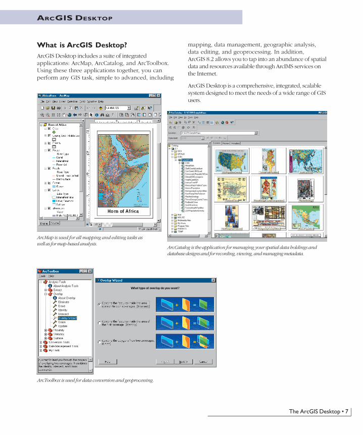
What is ArcGIS Desktop?ArcGIS Desktop includes a suite of integratedapplications: ArcMap, ArcCatalog, and ArcToolbox.Using these three applications together, you canperform any GIS task, simple to advanced, including
mapping, data management, geographic analysis,data editing, and geoprocessing. In addition,ArcGIS 8.2 allows you to tap into an abundance of spatialdata and resources available through ArcIMS services onthe Internet.
ArcGIS Desktop is a comprehensive, integrated, scalablesystem designed to meet the needs of a wide range of GISusers.
ArcMap is used for all mapping and editing tasks aswell as for map-based analysis.
ArcCatalog is the application for managing your spatial data holdings anddatabase designs and for recording, viewing, and managing metadata.
ArcToolbox is used for data conversion and geoprocessing.
ch02.p65 04/25/2002, 10:59 AM7
8 • What is ArcGIS?
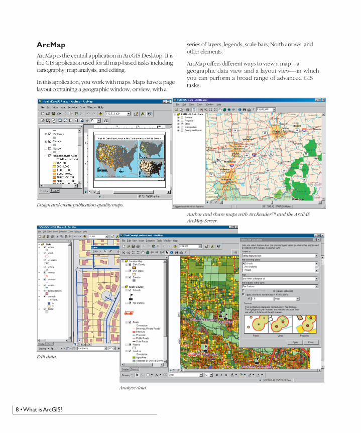
ArcMapArcMap is the central application in ArcGIS Desktop. It isthe GIS application used for all map-based tasks includingcartography, map analysis, and editing.
In this application, you work with maps. Maps have a pagelayout containing a geographic window, or view, with a
series of layers, legends, scale bars, North arrows, andother elements.
ArcMap offers different ways to view a map—ageographic data view and a layout view—in whichyou can perform a broad range of advanced GIStasks.
Design and create publication-quality maps.
Author and share maps with ArcReader™ and the ArcIMSArcMap Server.
Edit data.
Analyze data.
ch02.p65 04/25/2002, 10:59 AM8
The ArcGIS Desktop • 9
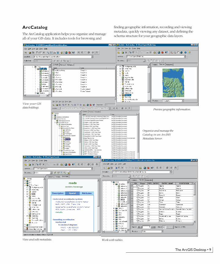
ArcCatalogThe ArcCatalog application helps you organize and manageall of your GIS data. It includes tools for browsing and
finding geographic information, recording and viewingmetadata, quickly viewing any dataset, and defining theschema structure for your geographic data layers.
Organize and manage theCatalog in an ArcIMSMetadata Server.
Work with tables.View and edit metadata.
Preview geographic information.
View your GISdata holdings.
ch02.p65 04/25/2002, 11:00 AM9
10 • What is ArcGIS?
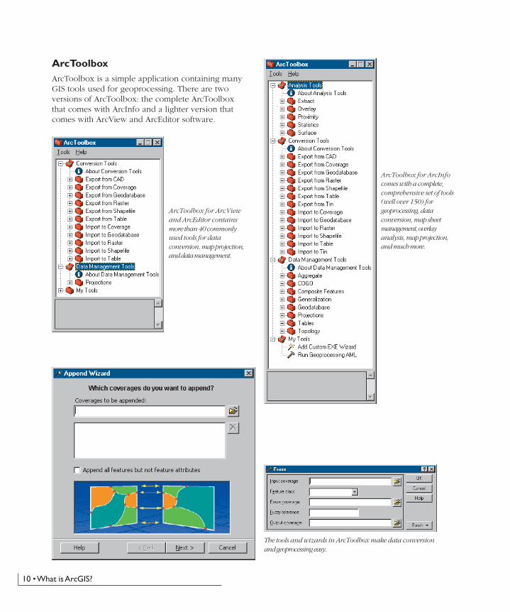
ArcToolboxArcToolbox is a simple application containing manyGIS tools used for geoprocessing. There are twoversions of ArcToolbox: the complete ArcToolboxthat comes with ArcInfo and a lighter version thatcomes with ArcView and ArcEditor software.
ArcToolbox for ArcViewand ArcEditor containsmore than 40 commonlyused tools for dataconversion, map projection,and data management.
ArcToolbox for ArcInfocomes with a complete,comprehensive set of tools(well over 150) forgeoprocessing, dataconversion, map sheetmanagement, overlayanalysis, map projection,and much more.
The tools and wizards in ArcToolbox make data conversionand geoprocessing easy.
ch02.p65 04/25/2002, 11:00 AM10
The ArcGIS Desktop • 11
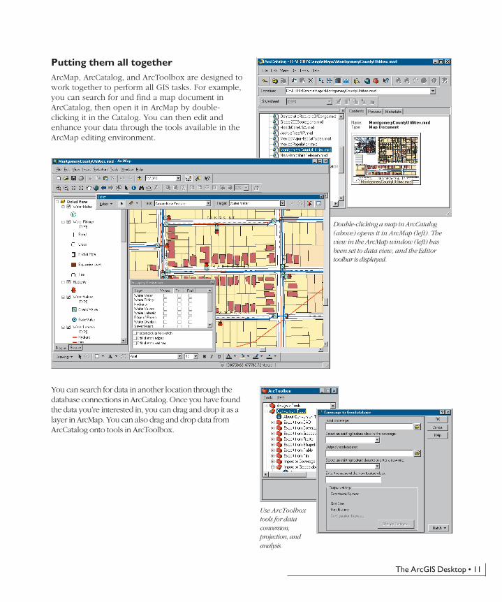
Putting them all togetherArcMap, ArcCatalog, and ArcToolbox are designed towork together to perform all GIS tasks. For example,you can search for and find a map document inArcCatalog, then open it in ArcMap by double-clicking it in the Catalog. You can then edit andenhance your data through the tools available in theArcMap editing environment.
You can search for data in another location through thedatabase connections in ArcCatalog. Once you have foundthe data you’re interested in, you can drag and drop it as alayer in ArcMap. You can also drag and drop data fromArcCatalog onto tools in ArcToolbox.
Double-clicking a map in ArcCatalog(above) opens it in ArcMap (left). Theview in the ArcMap window (left) hasbeen set to data view, and the Editortoolbar is displayed.
Use ArcToolboxtools for dataconversion,projection, andanalysis.
ch02.p65 04/25/2002, 11:00 AM11
12 • What is ArcGIS?
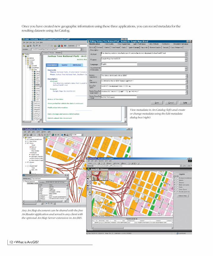
Once you have created new geographic information using these three applications, you can record metadata for theresulting datasets using ArcCatalog.
View metadata in ArcCatalog (left) and createor change metadata using the Edit metadatadialog box (right).
Any ArcMap document can be shared with the freeArcReader application and served to any client withthe optional ArcMap Server extension in ArcIMS.
ch02.p65 04/25/2002, 11:00 AM12
The ArcGIS Desktop • 13
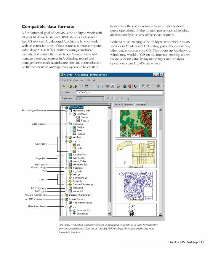
Compatible data formatsA fundamental goal of ArcGIS is the ability to work withall your file-based data and DBMS data as well as withArcIMS services. ArcMap and ArcCatalog let you workwith an extensive array of data sources, such as computer-aided design (CAD) files, numerous image and tableformats, and many other data types. You can view andmanage these data sources in ArcCatalog, record andmanage their metadata, and search for data sources basedon their content. In ArcMap, map layers can be created
from any of these data sources. You can also performquery operations, on-the-fly map projections, table joins,and map analysis on any of these data sources.
Perhaps most exciting is the ability to work with ArcIMSservices in ArcMap and ArcCatalog, just as you would anyother data source in your GIS. This opens up ArcMap to awhole new world of GIS on the Internet. ArcMap allowsyou to perform virtually any mapping or map analysisoperation on an ArcIMS data source.
Personal geodatabase
ArcView, ArcEditor, and ArcInfo can work with a wide range of data formats andconnect to relational databases (via ArcSDE) to ArcIMS services including newMetadata Services.
CAD dataset
Coverages
Shapefiles
DBF table
TIN
Layers
CAD drawingDAT table
ArcSDE Connection
ArcIMS Connection
Metadata Server
Raster image
ch02.p65 04/25/2002, 11:00 AM13

14 • What is ArcGIS?
What are ArcView, ArcEditor, andArcInfo?ArcGIS Desktop can be accessed using three softwareproducts, each providing a higher level of functionality.
ArcView provides comprehensive mapping and analysistools along with simple editing and geoprocessing tools.
ArcEditor includes advanced editing capabilities forcoverages and geodatabases in addition to the fullfunctionality of ArcView.
ArcInfo extends the functionality of both to includeadvanced geoprocessing. It also includes the legacyapplications for ArcInfo Workstation (Arc, ArcPlot™,ArcEdit™, and so on).
Geo-processing
Mapanalysis
Editing
GIS datamanagement
Datasupport
Cartography
Developertools
ArcInfo onlyArcEditor andArcInfo
ArcView, ArcEditor, andArcInfo
� Work with shapefiles, coverages,geodatabases, and ArcIMS services
� Work with the Geography NetworkSM
� Work with any DBMS� Work with many table formats� Read access to any geodatabase� Work with many raster formats
+
+
� Full read-write andtransactional accessto any geodatabase
� Load rasters intoDBMS with ArcSDE
� Advanced mapping and query� Map authoring� Map templates� Thousands of symbols and styles
� ArcPlot: command-based mappingapplication
� Advanced map analysis� Report writing� Charting and business graphics
� New ArcCatalog application for GIS datamanagement
� Schema management for shapefiles� Metadata creation and management
� Schema managementfor coverages andgeodatabases
� Version managementon any multiusergeodatabase (ArcSDErequired)
� Edit shapefiles and simple, personalgeodatabases
� ArcEdit: command-based editingapplication
� Edit coverages and allgeodatabases
� Versioning tools� Dimensions
� Simple geoprocessing and data conversion� Create shapefiles and simple, personal
geodatabases� Load shapefile data into simple, personal
geodatabases
� Create and loadadvancedgeodatabases
� Arc: command-basedapplication
� Full geoprocessing anddata conversion
� Vector overlay� Managing map sheets� Map projection and
coordinatemanagement
� Remote geoprocessingserver
� Customization with VBA� ArcObjects™ COM Library� GUI customization
� AML™ & ODE inArcInfo Workstation
+
+ +
+ +
+
ch02.p65 04/25/2002, 11:00 AM14

The ArcGIS Desktop • 15
Because ArcView, ArcEditor, and ArcInfo all share acommon architecture, users working with any of theseclients can share their work with other users. Maps, data,symbology, map layers, custom tools and interfaces,reports, metadata, and so on, can be accessedinterchangeably in all three products. This means that youget the benefit of using a single architecture, minimizingthe need to learn and deploy several differentarchitectures.
In addition, maps data, and metadata created withArcGIS Desktop can be shared with many users throughthe use of free ArcReader seats and advanced GIS Webservices using ArcIMS.
The capabilities of all three levels can be further extendedusing a series of optional add-on software extensions suchas ArcGIS Spatial Analyst and ArcPress™. For moreinformation on the extension software, see ‘Optionalextensions for ArcGIS Desktop’ later in this section.
ArcGIS Desktop is available in three options: ArcView, ArcEditor, and ArcInfo. All three share a common user interface anddeveloper tools and work with the same data.
ch02.p65 04/25/2002, 11:00 AM15
16 • What is ArcGIS?
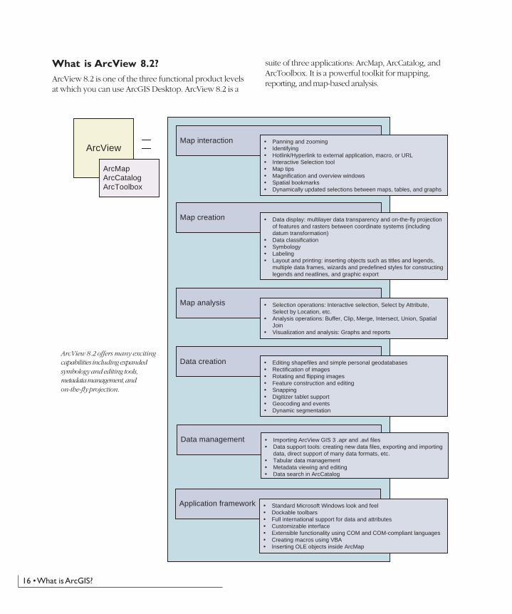
What is ArcView 8.2?ArcView 8.2 is one of the three functional product levelsat which you can use ArcGIS Desktop. ArcView 8.2 is a
suite of three applications: ArcMap, ArcCatalog, andArcToolbox. It is a powerful toolkit for mapping,reporting, and map-based analysis.
ArcView
Map analysis
Map interaction � Panning and zooming� Identifying� Hotlink/Hyperlink to external application, macro, or URL� Interactive Selection tool� Map tips� Magnification and overview windows� Spatial bookmarks� Dynamically updated selections between maps, tables, and graphs
Map creation � Data display: multilayer data transparency and on-the-fly projectionof features and rasters between coordinate systems (includingdatum transformation)
� Data classification� Symbology� Labeling� Layout and printing: inserting objects such as titles and legends,
multiple data frames, wizards and predefined styles for constructinglegends and neatlines, and graphic export
ArcMapArcCatalogArcToolbox
Data creation
Data management
Application framework
� Selection operations: Interactive selection, Select by Attribute,Select by Location, etc.
� Analysis operations: Buffer, Clip, Merge, Intersect, Union, SpatialJoin
� Visualization and analysis: Graphs and reports
� Editing shapefiles and simple personal geodatabases� Rectification of images� Rotating and flipping images� Feature construction and editing� Snapping� Digitizer tablet support� Geocoding and events� Dynamic segmentation
� Importing ArcView GIS 3 .apr and .avl files� Data support tools: creating new data files, exporting and importing
data, direct support of many data formats, etc.� Tabular data management� Metadata viewing and editing� Data search in ArcCatalog
� Standard Microsoft Windows look and feel� Dockable toolbars� Full international support for data and attributes� Customizable interface� Extensible functionality using COM and COM-compliant languages� Creating macros using VBA� Inserting OLE objects inside ArcMap
ArcView 8.2 offers many excitingcapabilities including expandedsymbology and editing tools,metadata management, andon-the-fly projection.
ch02.p65 04/25/2002, 11:00 AM16
The ArcGIS Desktop • 17
ArcView 8.2 is functionally equivalent toArcView GIS 3—tasks you performed withArcView GIS 3 can be done with ArcView 8.2.
In addition, many more exciting capabilities have beenadded in version 8.2. For example, both symbology andediting tools have been greatly expanded, and the standardWindows interface comes equipped with multiple wizardsto help you create, maintain, and update your data andmaps. Other additional capabilities include metadatamanagement and data searching with ArcCatalog, simplegeodatabase editing, annotation support, on-the-flyprojection of features and rasters between coordinatesystems, and the ability to connect to and use ArcIMSservices. ArcView 8.2 can also be customized using theindustry-standard Microsoft® Visual Basic® forApplications (VBA), which is included with ArcView 8.2.
ch02.p65 04/25/2002, 11:00 AM17
18 • What is ArcGIS?
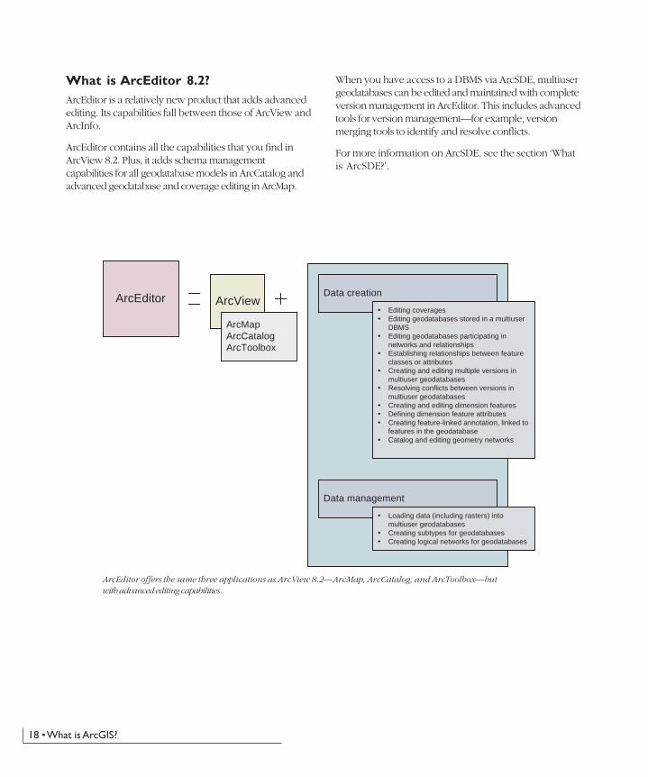
What is ArcEditor 8.2?ArcEditor is a relatively new product that adds advancedediting. Its capabilities fall between those of ArcView andArcInfo.
ArcEditor contains all the capabilities that you find inArcView 8.2. Plus, it adds schema managementcapabilities for all geodatabase models in ArcCatalog andadvanced geodatabase and coverage editing in ArcMap.
When you have access to a DBMS via ArcSDE, multiusergeodatabases can be edited and maintained with completeversion management in ArcEditor. This includes advancedtools for version management—for example, versionmerging tools to identify and resolve conflicts.
For more information on ArcSDE, see the section ‘Whatis ArcSDE?’.
ArcEditor offers the same three applications as ArcView 8.2—ArcMap, ArcCatalog, and ArcToolbox—butwith advanced editing capabilities.
ArcEditor ArcViewData creation
� Editing coverages� Editing geodatabases stored in a multiuser
DBMS� Editing geodatabases participating in
networks and relationships� Establishing relationships between feature
classes or attributes� Creating and editing multiple versions in
multiuser geodatabases� Resolving conflicts between versions in
multiuser geodatabases� Creating and editing dimension features� Defining dimension feature attributes� Creating feature-linked annotation, linked to
features in the geodatabase� Catalog and editing geometry networks
Data management
� Loading data (including rasters) into multiuser geodatabases
� Creating subtypes for geodatabases� Creating logical networks for geodatabases
ArcMapArcCatalogArcToolbox
ch02.p65 04/25/2002, 11:00 AM18
The ArcGIS Desktop • 19
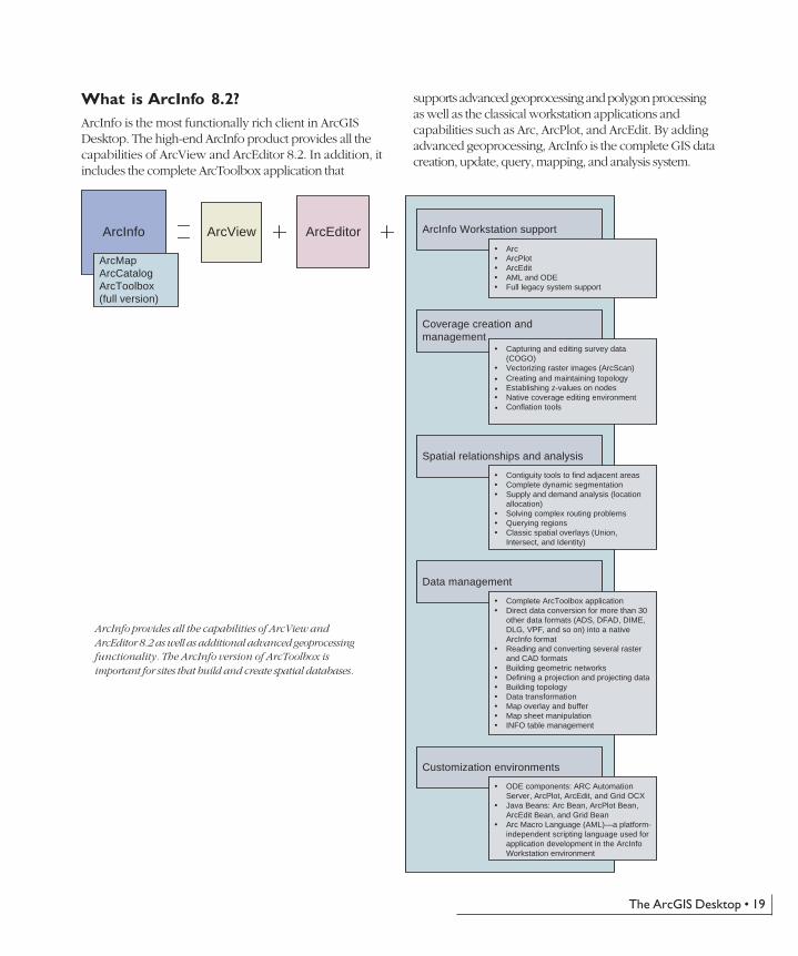
What is ArcInfo 8.2?ArcInfo is the most functionally rich client in ArcGISDesktop. The high-end ArcInfo product provides all thecapabilities of ArcView and ArcEditor 8.2. In addition, itincludes the complete ArcToolbox application that
supports advanced geoprocessing and polygon processingas well as the classical workstation applications andcapabilities such as Arc, ArcPlot, and ArcEdit. By addingadvanced geoprocessing, ArcInfo is the complete GIS datacreation, update, query, mapping, and analysis system.
ArcInfo ArcView
Data management
Coverage creation andmanagement
� Capturing and editing survey data(COGO)
� Vectorizing raster images (ArcScan)� Creating and maintaining topology� Establishing z-values on nodes� Native coverage editing environment� Conflation tools
Spatial relationships and analysis
� Contiguity tools to find adjacent areas� Complete dynamic segmentation� Supply and demand analysis (location
allocation)� Solving complex routing problems� Querying regions� Classic spatial overlays (Union,
Intersect, and Identity)
ArcEditor
Customization environments
� Complete ArcToolbox application� Direct data conversion for more than 30
other data formats (ADS, DFAD, DIME,DLG, VPF, and so on) into a nativeArcInfo format
� Reading and converting several rasterand CAD formats
� Building geometric networks� Defining a projection and projecting data� Building topology� Data transformation� Map overlay and buffer� Map sheet manipulation� INFO table management
� ODE components: ARC AutomationServer, ArcPlot, ArcEdit, and Grid OCX
� Java Beans: Arc Bean, ArcPlot Bean,ArcEdit Bean, and Grid Bean
� Arc Macro Language (AML)—a platform-independent scripting language used forapplication development in the ArcInfoWorkstation environment
ArcInfo Workstation support
� Arc� ArcPlot� ArcEdit� AML and ODE� Full legacy system support
ArcMapArcCatalogArcToolbox(full version)
ArcInfo provides all the capabilities of ArcView andArcEditor 8.2 as well as additional advanced geoprocessingfunctionality. The ArcInfo version of ArcToolbox isimportant for sites that build and create spatial databases.
ch02.p65 04/25/2002, 11:00 AM19
20 • What is ArcGIS?
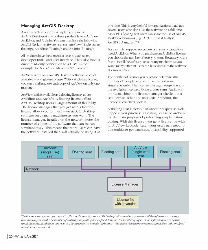
Managing ArcGIS DesktopAs explained earlier in this chapter, you can useArcGIS Desktop at any of three product levels: ArcView,ArcEditor, and ArcInfo. You can purchase the followingArcGIS Desktop software licenses: ArcView (single use orfloating), ArcEditor (floating), and ArcInfo (floating).
All products have the same data access, extensions,developer tools, and user interface. They also have adirect read-only connection to a DBMS—forexample, to Oracle® and Microsoft SQL Server™.
ArcView is the only ArcGIS Desktop software productavailable as a single-use license. With a single-use license,you can install and use each copy of ArcView on only onemachine.
ArcView is also available as a floating license, as areArcEditor and ArcInfo. A floating license offersArcGIS Desktop users a large amount of flexibility.The license manager that you get with a floatinglicense allows you to install your ArcGIS Desktopsoftware on as many machines as you want. Thelicense manager, installed on the network, notes thenumber of copies of the software that can be runsimultaneously. This means that more users can havethe software installed than will actually be using it at
one time. This is very helpful for organizations that haveseveral users who don’t use the software on a full-timebasis. Plus floating seat users can share the use of ArcGISDesktop extensions (e.g., ArcGIS Spatial Analyst,ArcGIS 3D Analyst™).
For example, suppose several users in your organizationneed ArcEditor. When you purchase an ArcEditor license,you choose the number of seats you want. Because you arefree to install the software on as many machines as youwant, many different users can have access to the softwareat various times.
The number of licenses you purchase determines thenumber of people who can use the softwaresimultaneously. The license manager keeps track ofthe available licenses. Once a user starts ArcEditoron his machine, the license manager checks out aseat license. When the user exits ArcEditor, thelicense is checked back in.
A floating seat is flexible in another respect as well.Suppose you purchase a floating license of ArcViewfor the main purpose of performing simple featureediting. With this license, you get a license file withan ArcView keycode. Later, your users may need toedit multiuser geodatabases, a capability supported
The license manager that you get with a floating license of your ArcGIS Desktop software allows you to install the software on as manymachines as you want. The number of seats in your floating license file determines the number of copies of the software that can be runsimultaneously. In addition, ArcView can be purchased in a single-use license—this means that each copy can be installed on only one fixedmachine on your network.
ch02.p65 04/25/2002, 11:00 AM20
The ArcGIS Desktop • 21
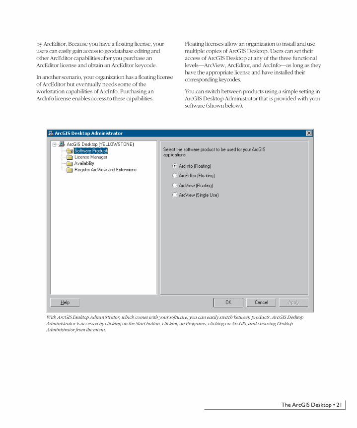
by ArcEditor. Because you have a floating license, yourusers can easily gain access to geodatabase editing andother ArcEditor capabilities after you purchase anArcEditor license and obtain an ArcEditor keycode.
In another scenario, your organization has a floating licenseof ArcEditor but eventually needs some of theworkstation capabilities of ArcInfo. Purchasing anArcInfo license enables access to these capabilities.
Floating licenses allow an organization to install and usemultiple copies of ArcGIS Desktop. Users can set theiraccess of ArcGIS Desktop at any of the three functionallevels—ArcView, ArcEditor, and ArcInfo—as long as theyhave the appropriate license and have installed theircorresponding keycodes.
You can switch between products using a simple setting inArcGIS Desktop Administrator that is provided with yoursoftware (shown below).
With ArcGIS Desktop Administrator, which comes with your software, you can easily switch between products. ArcGIS DesktopAdministrator is accessed by clicking on the Start button, clicking on Programs, clicking on ArcGIS, and choosing DesktopAdministrator from the menu.
ch02.p65 04/25/2002, 11:00 AM21
22 • What is ArcGIS?
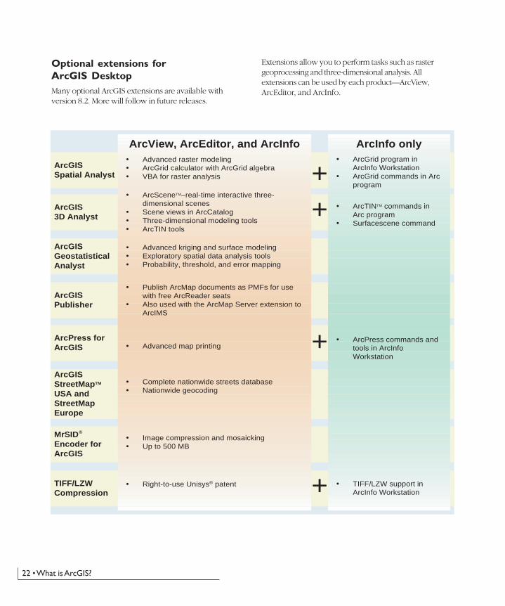
Optional extensions forArcGIS DesktopMany optional ArcGIS extensions are available withversion 8.2. More will follow in future releases.
Extensions allow you to perform tasks such as rastergeoprocessing and three-dimensional analysis. Allextensions can be used by each product—ArcView,ArcEditor, and ArcInfo.
ArcGISGeostatisticalAnalyst
ArcGISSpatial Analyst
ArcGIS3D Analyst
ArcPress forArcGIS
TIFF/LZWCompression
ArcGISStreetMapTM
USA andStreetMapEurope
MrSIDEncoder forArcGIS
ArcGISPublisher
ArcInfo onlyArcView, ArcEditor, and ArcInfo
Advanced kriging and surface modelingExploratory spatial data analysis toolsProbability, threshold, and error mapping
Advanced map printing
Complete nationwide streets databaseNationwide geocoding
Image compression and mosaickingUp to 500 MB
Right-to-use Unisys® patent
ArcSceneTM–real-time interactive three-dimensional scenesScene views in ArcCatalogThree-dimensional modeling toolsArcTIN tools
TIFF/LZW support inArcInfo Workstation
ArcPress commands andtools in ArcInfoWorkstation
ArcTINTM commands inArc programSurfacescene command
+
+
+
+
Publish ArcMap documents as PMFs for usewith free ArcReader seatsAlso used with the ArcMap Server extension toArcIMS
Advanced raster modelingArcGrid calculator with ArcGrid algebraVBA for raster analysis
ArcGrid program inArcInfo WorkstationArcGrid commands in Arcprogram
�
ch02.p65 04/25/2002, 11:00 AM22
The ArcGIS Desktop • 23
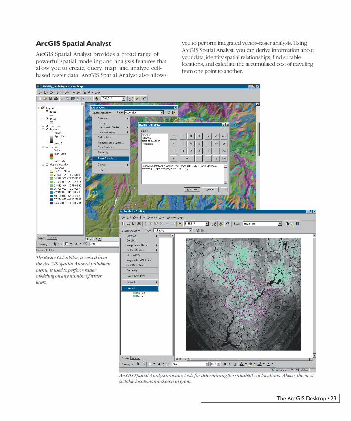
ArcGIS Spatial AnalystArcGIS Spatial Analyst provides a broad range ofpowerful spatial modeling and analysis features thatallow you to create, query, map, and analyze cell-based raster data. ArcGIS Spatial Analyst also allows
you to perform integrated vector–raster analysis. UsingArcGIS Spatial Analyst, you can derive information aboutyour data, identify spatial relationships, find suitablelocations, and calculate the accumulated cost of travelingfrom one point to another.
ArcGIS Spatial Analyst provides tools for determining the suitability of locations. Above, the mostsuitable locations are shown in green.
The Raster Calculator, accessed fromthe ArcGIS Spatial Analyst pulldownmenu, is used to perform rastermodeling on any number of rasterlayers.
ch02.p65 04/25/2002, 11:00 AM23
24 • What is ArcGIS?
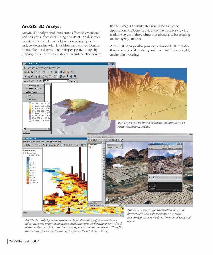
ArcGIS 3D AnalystArcGIS 3D Analyst enables users to effectively visualizeand analyze surface data. Using ArcGIS 3D Analyst, youcan view a surface from multiple viewpoints, query asurface, determine what is visible from a chosen locationon a surface, and create a realistic perspective image bydraping raster and vector data over a surface. The core of
the ArcGIS 3D Analyst extension is the ArcSceneapplication. ArcScene provides the interface for viewingmultiple layers of three-dimensional data and for creatingand analyzing surfaces.
ArcGIS 3D Analyst also provides advanced GIS tools forthree-dimensional modeling such as cut–fill, line of sight,and terrain modeling.
3D Analyst includes three-dimensional visualization andterrain modeling capabilities.
ArcGIS 3D Analyst provides effective tools for illustrating differences betweenadjoining areas or regions on a map. In this example, the third dimension of eachof the northeastern U.S. counties shown represents population density. The tallerthe column representing the county, the greater the population density.
ArcGIS 3D Analyst offers animation tools andfunctionality. This example shows a movie fileincluding animation of a three-dimensional scene andobjects.
ch02.p65 04/25/2002, 11:00 AM24
The ArcGIS Desktop • 25
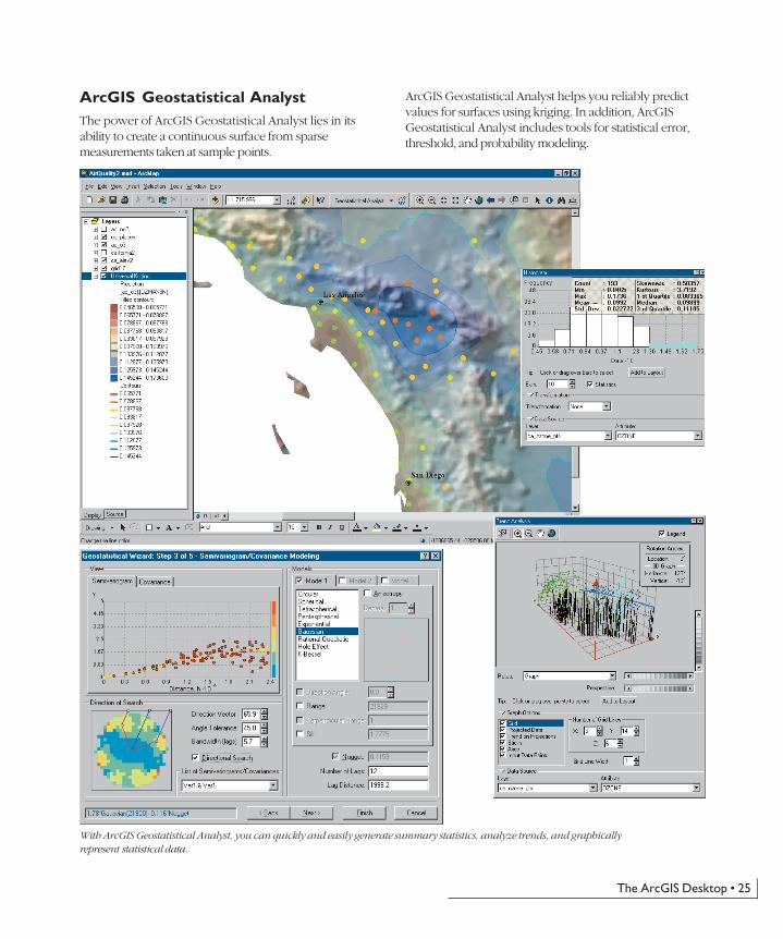
ArcGIS Geostatistical AnalystThe power of ArcGIS Geostatistical Analyst lies in itsability to create a continuous surface from sparsemeasurements taken at sample points.
ArcGIS Geostatistical Analyst helps you reliably predictvalues for surfaces using kriging. In addition, ArcGISGeostatistical Analyst includes tools for statistical error,threshold, and probability modeling.
With ArcGIS Geostatistical Analyst, you can quickly and easily generate summary statistics, analyze trends, and graphicallyrepresent statistical data.
ch02.p65 04/25/2002, 11:00 AM25

26 • What is ArcGIS?
StreetMap allows you to add a graphic to the map at a specified address. StreetMap data can be viewed at national, state, regional, and locallevels, with the symbology and visibility of map features changing with each level.
ArcGIS StreetMap USA andStreetMapEuropeThe ArcGIS StreetMap extensions provide street-levelmapping and address matching for entire countries.StreetMap layers automatically manage, label, and draw
features, such as local landmarks, streets, parks, waterbodies, and other features. StreetMap can find nearly anyaddress in each country by interactively matching a singleaddress or by batch matching from a file of addresses. Allthe data comes compressed on a small set of CD–ROMs.
StreetMap USA
StreetMap Europe
ch02.p65 04/25/2002, 11:00 AM26
The ArcGIS Desktop • 27
ArcGIS PublisherArcGIS Publisher enables the creation of a published mapfile format (PMF) for any ArcMap document. PMFs areused in the free ArcReader application and allow you toshare your ArcMap documents with any number of users.The PMF format can also be used to deploy your map overthe Web or Intranet through the ArcMap Server extensionfor ArcIMS.
Adding a copy of ArcGIS Publisher to your ArcGISDesktop allows you to open up access to your spatialinformation to many users. Use ArcMap to authorinteractive maps. Publish them with ArcGIS Publisher.And share them with many users via ArcReader and theArcMap Server extension for ArcIMS.
ArcPress for ArcGISArcPress is the map printing extension for ArcView,ArcEditor, and ArcInfo. As ESRI’s raster image processor(RIP), ArcPress renders standard graphics exchangeformats and native printer language print files for printingon industry-standard wide-format and desktop printers.
Large-format GIS maps may include vast data volumes,complex symbology, and extremely large images that areoften difficult or time consuming to print on off-the-shelfprinters. The role of ArcPress in a GIS environment is torender high-quality maps on a printer quickly, withoutrequiring the addition of extra onboard memory orhardware. Instead, ArcPress turns your computer into aprint processor, allowing your printer to printcontinuously without the need for expensive hardwareupgrades.
MrSID Encoder for ArcGISMrSID is a high-quality, high-performance compressionmethodology for reducing the size of very large images.The MrSID Encoder extension gives you the ability to useArcToolbox to compress and mosaic images from 50 to500 MB in size. Images smaller than 50 MB can beencoded without this extension. The raster file size limit isnot based on file storage size, but instead on the numberof pixels. The 500 MB size rule will be evaluated asfollows:
50 million < Image Width * Image Height * Number ofBands < 500 million
The MrSID Encoder is developed by LizardTech, Inc.Additional products are available from LizardTech thatallow you to compress images of a larger size.
TIFF/LZW compressionOne of the methods available for image compression is theTIFF/LZW compression mechanism, a patented processowned by Unisys Corporation. While reading TIFF/LZWcompression is included with ArcGIS, the process ofcreating these image types requires a right-to-use licensefrom Unisys. Any user wishing to create images in thisform must first purchase a right-to-use license fromUnisys. ESRI will provide the TIFF/LZW compressionkeycode as an optional extension to enable this capabilityin ArcGIS Desktop and ArcInfo Workstation.
What is ArcReader?ArcReader is a free application to view and use mapscreated with ArcMap and the optional ArcGIS Publisherextension. ArcReader works on maps in PMF format.
Because ArcReader is free, any user can install it on theirWindows computer and have access to maps you generatewith ArcGIS. ArcMap documents contain access to manydata types—shapefiles, coverages, geodatabases, CAD files,tables, imagery, ArcIMS services, and so on, and providesadvanced symbology and map behavior, such as scale-dependent themes and projection on the fly. Any ArcMapdocument can easily be converted to the PMF formatusing the ArcGIS Publisher extension and subsequentlyshared with ArcReader users.
ArcReader helps you deploy your GIS in new ways. Itopens up access to your GIS data, enables you to presentinformation in high-quality professional maps, andprovides ArcReader users the ability to interactively useand print maps.
ch02.p65 04/25/2002, 11:00 AM27

ch02.p65 04/25/2002, 11:00 AM28
What is ArcSDE? • 29
WHAT IS ARCSDE?
• Have multiple users edit and maintain thegeodatabase. ArcSDE provides long transaction andversion support for your DBMS.
• Serve multiple ArcGIS users anywhere on yournetwork. Centralizing your DBMS server significantlyenhances performance for large multiuser systems.
• Open your ArcGIS geodatabase to other users whouse MapObjects®, ArcView GIS 3, and CADapplications.
• Serve your data openly using ArcIMS Web services.
• Build Open GIS Consortium (OGC)-compliantapplications that work with features in yourgeodatabase.
• Build SQL applications that work with the tables androws in the geodatabase.
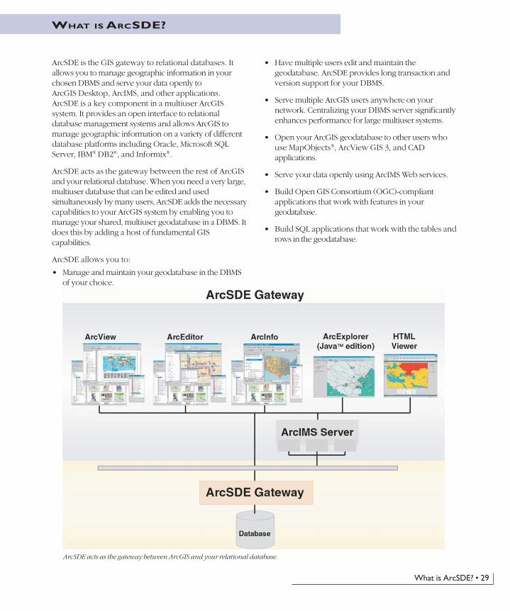
ArcSDE acts as the gateway between ArcGIS and your relational database.
ArcSDE is the GIS gateway to relational databases. Itallows you to manage geographic information in yourchosen DBMS and serve your data openly toArcGIS Desktop, ArcIMS, and other applications.ArcSDE is a key component in a multiuser ArcGISsystem. It provides an open interface to relationaldatabase management systems and allows ArcGIS tomanage geographic information on a variety of differentdatabase platforms including Oracle, Microsoft SQLServer, IBM® DB2®, and Informix®.
ArcSDE acts as the gateway between the rest of ArcGISand your relational database. When you need a very large,multiuser database that can be edited and usedsimultaneously by many users, ArcSDE adds the necessarycapabilities to your ArcGIS system by enabling you tomanage your shared, multiuser geodatabase in a DBMS. Itdoes this by adding a host of fundamental GIScapabilities.
ArcSDE allows you to:
• Manage and maintain your geodatabase in the DBMSof your choice.
Ch03.p65 04/25/2002, 11:08 AM29

30 • What is ArcGIS?
Why would you use a DBMS?Multiuser GIS requires DBMS and strong GIS tools towork with the geographic data. As your organizationevolves, your spatial database will grow in size and innumber of users. Using a DBMS is a practical means forsharing and protecting your data investments.
Admittedly, the use of DBMS in GIS today is notwidespread. For years file formats have been used tomanage and share information using coverages,shapefiles, grids, TINs, CAD drawings, and manyraster formats. There were some clear advantages todoing this. First, it was easy and inexpensive. Everyonecould edit and manage their file-based data.No DBMS investment was necessary. Plus, DBMSslacked the ability to manage the larger, more complexdata types and support for operations required by GIS(for example, to execute a single query to fetch a fewthousand features for display in a particular map extentor to edit features using a long transaction that canlast for many days and even weeks).
As DBMS has evolved into more powerful technologythat could support complex data objects, larger queries,and stronger transactional support, the use of DBMS forgeographic data management has become much morepractical. Most multiuser GIS systems today manage theirtabular data in a DBMS, and many are beginning themigration of their geographic information into a DBMS.
Like other information resources in an organization, GISdata can benefit from DBMS use. It makes good businesssense to manage your GIS information resource as part ofyour relational database. Some of the reasons to userelational databases are as valid for GIS as they are forother information:
• A single data store
• Concurrency management in a multiuser environment
• Standard data management practices such as backup,recovery, and replication
• Performance for any number of users
• The need for managed and organized data
• Scalable data volumes with no size limitations
• Centralized systemwide or companywide access to thedata
• Data maintenance over long time periods, spanningpersonnel changes and hardware/software upgrades
• System failure/recovery mechanisms
• Industry-standard client/server and Internetarchitectures (e.g., Web Services)
ArcSDE plays an important role in a multiuser GIS by providing these three fundamental capabilities.
ArcSDE fundamental capabilities
Ch03.p65 04/25/2002, 11:08 AM30

What is ArcSDE? • 31
Why use ArcSDE?If you need a DBMS and you have spatial data, then youalso need ArcSDE to:
• Gain all of the benefits of using a DBMS.
• Store all geographic information in the DBMS, notjust the attributes.
• Allow multiple, simultaneous editors.
• Manage a GIS database of unlimited size.
• Manage spatial data using standard DBMS tables(adhere to ISO and Open GIS Consortium spatialstandards).
• Have a continuous and seamless (that is, not tiled)database.
• Model complex features and behavior required byGIS.
• Manage long transactions and versions.
• Apply the powerful ArcGIS tools on data stored in aDBMS.
To fit GIS into a coherent IT strategy
Many GIS users require that their GIS fits into a coherentinformation technology (IT) strategy for theirorganization. Simply put, their GIS must adhere to ITstandards; the GIS data should be managed as an integral
Multiuser geodatabase
Personal geodatabase
DBMS
ComputerComputer
PersonalDBMS
Geodatabases can scale from small, single-user personaldatabases to very large enterprisewide multiuser
databases. ArcSDE enables DBMSs of any scale to be sharedby many users.
Computer
AnyArcGIS Client
ArcSDE Gateway
AnyArcGIS Client
Computer Computer
Ch03.p65 04/25/2002, 11:08 AM31

32 • What is ArcGIS?
part of the organization’s data holdings, and access tothis data must be open and easy. The main role ofArcSDE and the geodatabase is to manage the integrationbetween a GIS and a DBMS.
To grow your GIS
Geodatabases can scale from small, single-user databasesto very large enterprisewide multiuser databases. Theprimary role of ArcSDE is to enable your geodatabase tobe shared by many users across any network and to scaleits size to any level necessary to meet your requirements.
ArcSDE connection configurationoptionsWhen configuring ArcGIS for a workgroup, department,or enterprise, you will need to implement a centralmultiuser geodatabase. ArcGIS seats—ArcReader,ArcIMS clients, ArcView, ArcEditor, and ArcInfo—willbe distributed throughout your organization, and perhapsbeyond. ArcGIS users will access shared data managed ina central geodatabase through ArcSDE.
ArcSDE can be configured to connect client applicationsto a DBMS directly or to run as an application server nearthe DBMS. There are advantages to each configuration,depending on your needs.
Direct connection configuration
ArcSDE can be configured to use direct connections. Theclient applications connect directly to the DBMS withoutusing an application server. Each ArcGIS and ArcIMSclient has the ArcSDE direct connection capability builtin. For example, ArcEditor and ArcInfo will look for anArcSDE keycode to enable editing and manipulation ofthe central geodatabase.
The direct connection configuration is often easier toinstall and administer. There is no need for installing andadministering the ArcSDE application server. Thisconfiguration allows for increased scalability because itoffloads work from the server to each connected client.
Application server configuration
Currently, the most common ArcSDE configurationincludes an ArcSDE Application Server. The applicationserver allows you to serve geographic data from a large,central geodatabase on UNIX®, Linux®, and Windows
servers to many users across a standard network. TheArcSDE Application Server is typically located on thesame hardware platform as your DBMS. The applicationserver configuration can offer performance advantages;during editing, it may be faster due to the intelligentArcSDE client/server architecture.
ArcSDE has both a direct connection configuration and anapplication server configuration.
Any Client
DBMS
TCP/IP
Server Platform
Direct Configuration
Any Client
DBMS
TCP/IP
Server Platform
ArcSDE Application Server
Application Server Configuration
Ch03.p65 04/25/2002, 11:08 AM32
What is ArcIMS? • 33
WHAT IS ARCIMS?
ArcIMS is an Internet-based GIS that allows you tocentrally build and deliver a wide range of GIS maps,data, and applications to users in your organization as wellas outside of your organization on the World Wide Web.ArcIMS includes both client and server technology. Itextends a Web site by enabling it to serve GIS data andapplications. Free HTML and Java viewers are includedwith ArcIMS, but ArcIMS can also work with a widerange of clients such as ArcGIS Desktop, ArcPad, wirelessdevices, and the new MapObjects for Java clients.
Why use ArcIMS?Expand your GIS. Disseminating GIS data and serviceson the Internet allows you to meet the GIS needs of manyusers. ArcIMS includes a set of HTML and Java viewersthat may be freely distributed to your users. These viewersprovide significant GIS functionality.
ArcIMS also caters to advanced GIS users. ArcIMSsignificantly improves the GIS experience of usersworking with ArcReader, ArcView, ArcEditor, andArcInfo. With the exception of editing tools, virtually allArcMap tools can be used with ArcIMS feature layers.
Integrate data from multiple sources. ArcIMSmakes it possible for users to combine data from anynumber of ArcIMS Web sites. It also enables theintegration of local GIS data with ArcIMS layers.Users can access your data and services, thenquickly and simply integrate them with data frommany other Internet and local sources.
Scale your system to meet your needs. Whetheryour server receives 10 or 10,000 map requests anhour, ArcIMS can be scaled to fit your needs. Then,as your site grows and map requests increase,ArcIMS can be easily extended to meet newdemands.
Provide access to GIS data and LocationServices. ArcIMS allows you to determine how andto whom GIS data and services are delivered. Youcontrol whether your data holdings are accessiblepublicly on the Web, on a secure network, or within yourorganization on a local area network (LAN).
ArcIMS is well suited for delivering Location Services andis already used by many key businesses. For example,ArcIMS is used in Location Services to find nearby ATMsand restaurants, generate trip plans and driving directions,
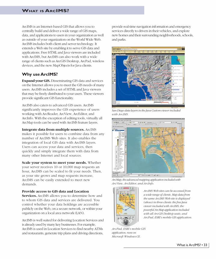
ArcMap, the advanced mapping application included withArcView, ArcEditor, and ArcInfo.
San Diego data layers in the Java Custom viewer includedwith ArcIMS.
ArcPad, ESRI’s mobile GISapplication, runs onMicrosoft Windows CE.
ArcIMS Web sites can be accessed froma wide range of clients. Map data fromthe same ArcIMS Web site is displayed(above) in three clients: the free Javaviewer included with ArcIMS; thepowerful ArcMap application includedwith all ArcGIS Desktop seats; andArcPad, ESRI’s mobile GIS application.
provide real-time navigation information and emergencyservices directly to drivers in their vehicles, and explorenew homes and their surrounding neighborhoods, schools,and parks.
Ch04.p65 04/25/2002, 11:13 AM33

34 • What is ArcGIS?
The ArcIMS architectureArcIMS runs in a distributed environment and consists ofboth client and server components. The ArcIMS servercomponents allow you to extend an Internet Web site byincluding GIS capabilities. Your ArcIMS Web site candeliver GIS data, maps, and applications.
With ArcIMS, you design and author a GIS Web site.Many types of client applications can connect to anduse your ArcIMS Web site over the Internet, rangingfrom the free HTML and Java viewers included withArcIMS to more advanced ArcGIS Desktop applications.
The ArcIMS architecture is highly scalable. Manyconcurrent users can access your Web site, andmany requests can be processed at one time. WithArcIMS, you can expand your server over time toaccommodate growth in demand. Because of itsscalable architecture, ArcIMS is as good a choice forsmall organizations serving dozens of maps a day asit is for large organizations serving hundreds ofthousands of maps a day.
The ArcIMS system consists of a series of clients (Java Viewer, HTML Viewer, and so on) that access GIS functionality and services provided by anArcIMS server. Client/Server connections are made over the Internet.
ArcExplorer(Java edition)
HTMLViewerJava
ArcIMS System
ArcIMS Server
Web Server
ArcView, ArcEditor,& ArcInfo Wireless
ApplicationsDataMaps
Ch04.p65 04/25/2002, 11:13 AM34
What is ArcIMS? • 35
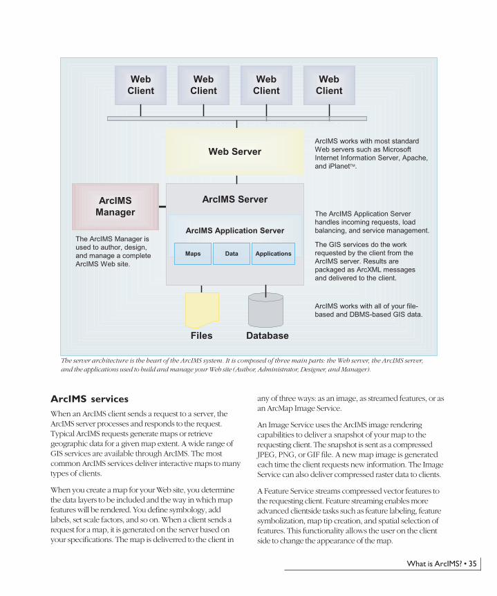
[[Insert ArcIMS server architecture graphic here.]]
ArcIMS servicesWhen an ArcIMS client sends a request to a server, theArcIMS server processes and responds to the request.Typical ArcIMS requests generate maps or retrievegeographic data for a given map extent. A wide range ofGIS services are available through ArcIMS. The mostcommon ArcIMS services deliver interactive maps to manytypes of clients.
When you create a map for your Web site, you determinethe data layers to be included and the way in which mapfeatures will be rendered. You define symbology, addlabels, set scale factors, and so on. When a client sends arequest for a map, it is generated on the server based onyour specifications. The map is deliverred to the client in
any of three ways: as an image, as streamed features, or asan ArcMap Image Service.
An Image Service uses the ArcIMS image renderingcapabilities to deliver a snapshot of your map to therequesting client. The snapshot is sent as a compressedJPEG, PNG, or GIF file. A new map image is generatedeach time the client requests new information. The ImageService can also deliver compressed raster data to clients.
A Feature Service streams compressed vector features tothe requesting client. Feature streaming enables moreadvanced clientside tasks such as feature labeling, featuresymbolization, map tip creation, and spatial selection offeatures. This functionality allows the user on the clientside to change the appearance of the map.
WebClient
WebClient
WebClient
WebClient
ArcIMSManager
ArcIMS Server
ArcIMS Application Server
Files Database
The ArcIMS Manager isused to author, design,and manage a completeArcIMS Web site.
ArcIMS works with most standardWeb servers such as MicrosoftInternet Information Server, Apache,and iPlanetTM.
The ArcIMS Application Serverhandles incoming requests, loadbalancing, and service management.
The GIS services do the workrequested by the client from theArcIMS server. Results arepackaged as ArcXML messagesand delivered to the client.
ArcIMS works with all of your file-based and DBMS-based GIS data.
Web Server
DataMaps Applications
The server architecture is the heart of the ArcIMS system. It is composed of three main parts: the Web server, the ArcIMS server,and the applications used to build and manage your Web site (Author, Administrator, Designer, and Manager).
Ch04.p65 04/25/2002, 11:13 AM35
36 • What is ArcGIS?
An ArcMap Image Service streams images from an ArcMapdocument to the requesting client. A new ArcIMSextension product—ArcMap Server—adds this capabilityto ArcIMS. This service enables you to deliver maps thatuse the advanced cartographic and open data accesscapabilities of ArcMap. Virtually any information andgraphic representations that you create in ArcMap can beserved using the ArcMap Server.
GIS capabilities in ArcIMS
Depending on your organization’s objectives and theaudience for whom you are building yourapplication, you may want to incorporate additionalGIS capabilities into your Web site. The following isa list of key GIS capabilities available with ArcIMS.
Image rendering. Image rendering takes a snapshotof the view that you created when you authoredyour map and delivers it to the client as acompressed JPEG, PNG, or GIF file. This capabilitycan also be used to serve raster datasets to yourusers.
Feature streaming. Feature streaming involvesstreaming vector features to clients, enabling anumber of clientside tasks: feature labeling, map tipcreation, spatial selection, and more. Feature streaming isonly available with thicker ArcIMS clients includingArcExplorer™, Java Edition, ArcMap, and the ArcIMSJava viewers. Streamed features from one ArcIMS site canbe integrated with streamed features from other ArcIMSsites as well as with local data and used together inanalysis.
Querying data. You can build new queries or runpredefined queries to derive specific information about thedata. The client submits the query to the server, and theserver returns query results to the client.
Data extraction. You can request real geographic datafrom the server. The server responds to a request for databy sending zipped shapefiles to the client. The user whoreceives the data is then able to extract the zippedshapefiles to a local hard drive.
Geocoding. Geocoding functionality allows you tosubmit a partial or complete address and view a mapshowing that location. Based on your input, the server
either returns an exact match to the address or a list ofcandidate matches.
Metadata catalog. A catalog that references your dataholdings and information sets can be created usingArcGIS, ArcIMS, and ArcSDE and published as a searchservice using ArcIMS. This allows you to provide an opensearch mechanism for users to find and access GISinformation at your Web site. You can create aclearinghouse and your users can participate in a SpatialData Infrastructure.
ArcMap Server (optional extension). This optionalextension to ArcIMS enables you to serve ArcMapdocuments openly as an ArcIMS service.
Author maps with ArcMap and serve them with ArcIMS.
Routing (optional extension). The optional ArcIMSRouteServer extension provides a countrywide navigationstreet database to support optimal routing and geocodingservices on the street data.
Ch04.p65 04/25/2002, 12:25 PM36
What is ArcIMS? • 37
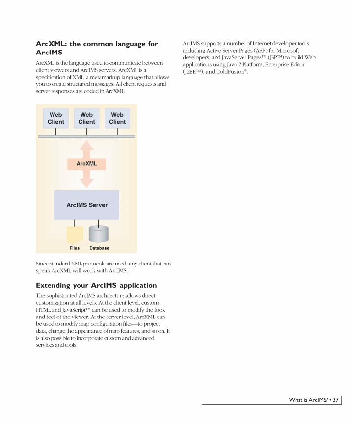
ArcXML: the common language forArcIMSArcXML is the language used to communicate betweenclient viewers and ArcIMS servers. ArcXML is aspecification of XML, a metamarkup language that allowsyou to create structured messages. All client requests andserver responses are coded in ArcXML.
Since standard XML protocols are used, any client that canspeak ArcXML will work with ArcIMS.
Extending your ArcIMS applicationThe sophisticated ArcIMS architecture allows directcustomization at all levels. At the client level, customHTML and JavaScript™ can be used to modify the lookand feel of the viewer. At the server level, ArcXML canbe used to modify map configuration files—to projectdata, change the appearance of map features, and so on. Itis also possible to incorporate custom and advancedservices and tools.
ArcIMS supports a number of Internet developer toolsincluding Active Server Pages (ASP) for Microsoftdevelopers, and JavaServer Pages™ (JSP™) to build Webapplications using Java 2 Platform, Enterprise Editor(J2EE™), and ColdFusion®.
Ch04.p65 04/25/2002, 12:25 PM37
38 • What is ArcGIS?
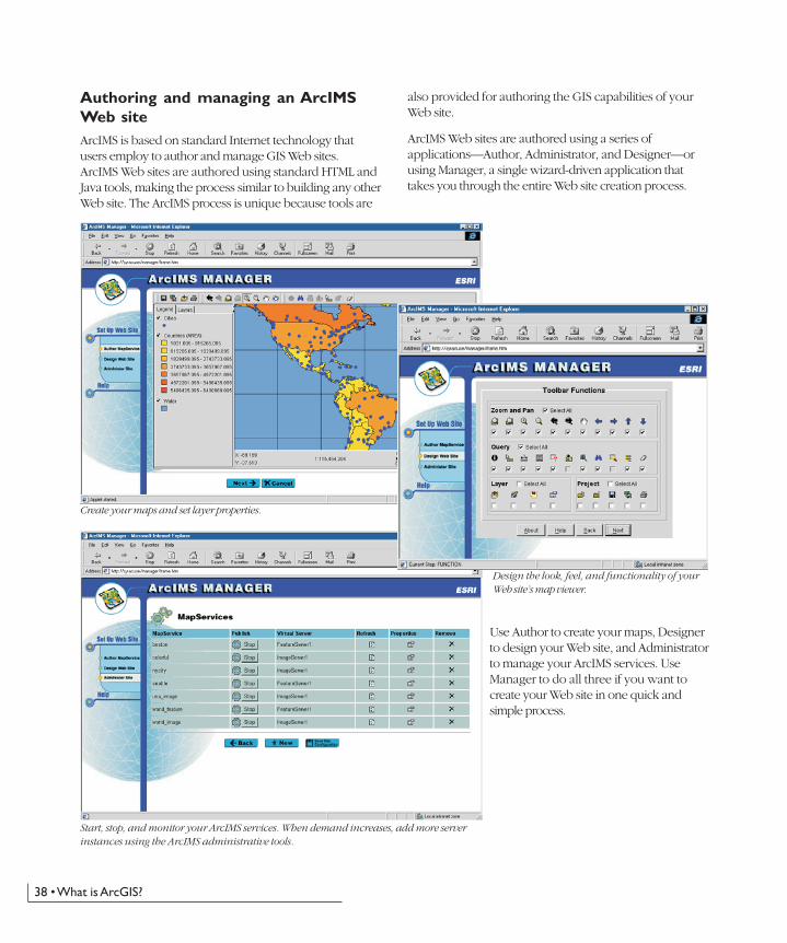
Authoring and managing an ArcIMSWeb siteArcIMS is based on standard Internet technology thatusers employ to author and manage GIS Web sites.ArcIMS Web sites are authored using standard HTML andJava tools, making the process similar to building any otherWeb site. The ArcIMS process is unique because tools are
also provided for authoring the GIS capabilities of yourWeb site.
ArcIMS Web sites are authored using a series ofapplications—Author, Administrator, and Designer—orusing Manager, a single wizard-driven application thattakes you through the entire Web site creation process.
Use Author to create your maps, Designerto design your Web site, and Administratorto manage your ArcIMS services. UseManager to do all three if you want tocreate your Web site in one quick andsimple process.
Create your maps and set layer properties.
Design the look, feel, and functionality of yourWeb site’s map viewer.
Start, stop, and monitor your ArcIMS services. When demand increases, add more serverinstances using the ArcIMS administrative tools.
Ch04.p65 04/25/2002, 12:25 PM38
What is ArcIMS? • 39
ArcIMS clientsA number of different clients can connect to and workwith ArcIMS services. Some clients are shipped withArcIMS, while others have the ability to connect to anduse ArcIMS Web sites. The set of possible ArcIMS clientsincludes:
• HTML and Java viewers delivered with ArcIMS
• ArcGIS Desktop: ArcView, ArcEditor, and ArcInfo
• ArcExplorer Java Edition
• Metadata Explorer
• MapObjects—Java Standard Edition (a new Javadeveloper kit to build applications for ArcIMS andArcGIS)
• ArcPad
• Wireless appliances such as cellular phones and personaldigital assistants (PDAs)
The HTML viewer
The HTML viewer is used for accessing image-based mapsand tabular data. It is a lightweight viewer—the simplestand fastest ArcIMS viewer to implement. You interactwith maps and attribute displays through a simple, yetpowerful, set of GIS tools. The HTML viewer can beembedded in any HTML Web site to create a dynamic,focused, interactive map for your users. This viewer givesthe site manager more control over what users can accessand do with GIS.
The HTML viewer does not support some GIS tools, nordoes it support data integration with local data. Despitebeing a lightweight client, however, the HTML viewer ishighly customizable and has the widest browser support.
The Java viewer
ArcIMS comes with two Java viewers. The Java Customviewer affords greater flexibility and functionality throughcustomization and is therefore very useful to an end userneeding substantial GIS power. The Java Standard vieweroffers a standard interface requiring no customization andwider browser support.
Both Java viewers are thicker clients containing rich setsof GIS tools. Both support feature streaming, whichenables a number of advanced GIS capabilities. For
example, simple editing notes and map notes can be addedby your users and collected by site administrators. Withthe Java viewers it is also possible to combine GIS datafrom many different local and Internet sites.
ArcIMS also contains a JavaServer Pages connector forJava 2 Platform, Enterprise Edition developers to buildserver applications.
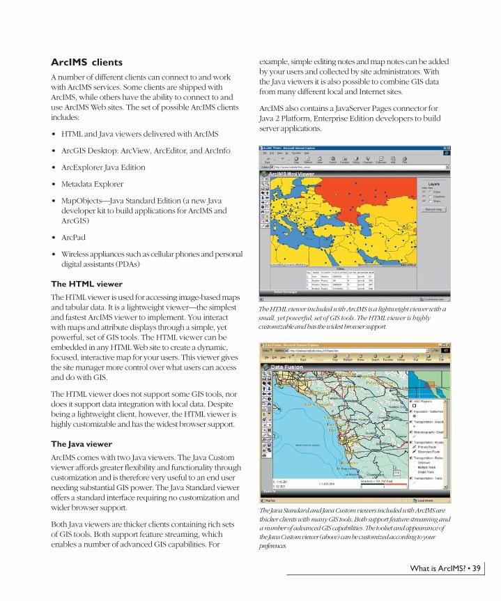
The HTML viewer included with ArcIMS is a lightweight viewer with asmall, yet powerful, set of GIS tools. The HTML viewer is highlycustomizable and has the widest browser support.
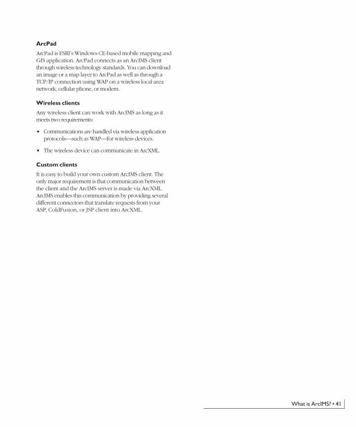
The Java Standard and Java Custom viewers included with ArcIMS arethicker clients with many GIS tools. Both support feature streaming anda number of advanced GIS capabilities. The toolset and appearance ofthe Java Custom viewer (above) can be customized according to yourpreferences.
Ch04.p65 04/25/2002, 12:25 PM39

40 • What is ArcGIS?
The Java edition of ArcExplorer can integrate ArcIMS layers with datafrom a variety of sources.
ArcMap (part of ArcGIS Desktop) works with ArcIMSlayers and can integrate data from multiple sources. Mostadvanced ArcMap tasks can be performed on ArcIMS layers.
ArcExplorer Java Edition
The Java edition of ArcExplorer has much in commonwith the Java viewers. What distinguishes it from the Javaviewers is the way it is implemented. ArcExplorer worksas an independent standalone application—not inside yourWeb browser. ArcExplorer can integrate layers from avariety of sources, both local and on the Internet.ArcExplorer can be freely downloaded from ESRI’sWeb site at www.esri.com.
Metadata Explorer
This ArcIMS client is a search tool that allows users toquery your metadata catalog and find and access GISinformation.
MapObjects—Java 2 Standard Edition
This rich software developer’s kit can be used with anyintegrated developer environment for Java to build Javaclients as well as server-based applications. MapObjects—Java contains a highly functional collection of developercomponents that can be used to build custom Java clientsthat run on any platform supporting Java.
ArcGIS Desktop
The best clients for working with ArcIMS are theArcGIS Desktop products: ArcReader, ArcView,ArcEditor, and ArcInfo. The ArcMap application withinArcGIS Desktop offers the fullest functionality of allpossible clients. In ArcMap, you can work equally wellwith shapefiles, coverages, geodatabases, and ArcIMSlayers. With the exception of editing, even the mostadvanced ArcMap tasks can be performed on ArcIMSlayers. The ability to integrate local data with geographicinformation from virtually anywhere in the world is amajor GIS breakthrough.
Any wireless client, such as ArcPad, canwork with ArcIMS as long ascommunications are in ArcXML and arehandled via WAP.
A custom Java application built with MapObjects—Java, the new JavaDeveloper Kit from ESRI
Ch04.p65 04/25/2002, 12:25 PM40
What is ArcIMS? • 41
ArcPad
ArcPad is ESRI’s Windows CE-based mobile mapping andGIS application. ArcPad connects as an ArcIMS clientthrough wireless technology standards. You can downloadan image or a map layer to ArcPad as well as through aTCP/IP connection using WAP on a wireless local areanetwork, cellular phone, or modem.
Wireless clients
Any wireless client can work with ArcIMS as long as itmeets two requirements:
• Communications are handled via wireless applicationprotocols—such as WAP—for wireless devices.
• The wireless device can communicate in ArcXML.
Custom clients
It is easy to build your own custom ArcIMS client. Theonly major requirement is that communication betweenthe client and the ArcIMS server is made via ArcXML.ArcIMS enables this communication by providing severaldifferent connectors that translate requests from yourASP, ColdFusion, or JSP client into ArcXML.
Ch04.p65 04/25/2002, 12:25 PM41
42 • What is ArcGIS?
What is G.net?
Background
There is widespread recognition that the data layers andtables in most GIS implementations come from multipleorganizations. A GIS organization will develop some, butnot all, of their data content. At least some of the layerswill be from external sources. Thus GIS data management,by its very nature, is distributed among many users.
Because GIS users are hungry for quality geographicinformation, there is a fundamental need for users to sharetheir data. Vast resources of information are available, butthe task of finding exactly what you need and knowingthe quality and currency of the information can bedaunting. GIS users need a mechanism to efficientlycatalog and search for available geospatial information.
The NSDI and GSDI vision
The NSDI, or National Spatial Data Infrastructure, is aconcept developed by the United States and othernational, state, and local governments. NSDI and GlobalSDI (GSDI) promote the vision of a framework for GISusers to openly share geographic information with oneanother.
The SDI concept describes requirements for computertechnologies, policies, and people necessary to promote thesharing of geospatial information throughout all levels ofgovernment, private industry, nongovernmentalorganizations, and the academic community. The SpatialData Infrastructure (SDI) interconnects GIS nodes acrossthe Internet—and, in many cases, over secure networks—to share information with one another openly (i.e., basedon standards).
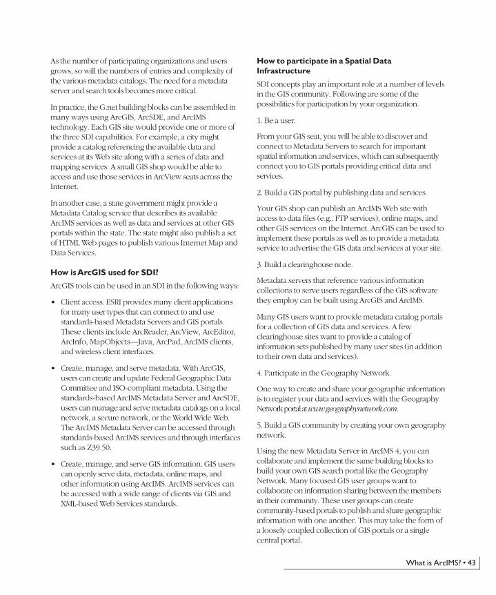
G.net: SDI building blocks from ESRI
G.net is how ESRI users participate in a Spatial DataInfrastructure with other users, regardless of their GIStechnology platform. G.net describes how ArcGIS,ArcIMS, ArcSDE, and other ESRI tools are used. AnyGIS organization wishing to participate will benefit fromusing these technologies.
A Spatial Data Infrastructure is built from threefundamental building blocks:
1. GIS users who search for useful geographic informationand connect to GIS portals for information access.
2. Metadata catalog servers that describe and referencegeographic information sets at various GIS portals.These are often referred to as clearinghouse nodes.
3. GIS portals that provide access to geographicinformation. The information can be delivered in manyforms such as FTP downloads, online maps, reports,Internet GIS services, data streaming services, andonline maps.
At its most basic level, a Spatial Data Infrastructure isrealized through catalogs holding metadata about availabledata and services. This is similar in function to the role ofthe card catalog in a library that references and organizesall library holdings.
�������������� ��������������
���� ������������������
�������������������������� �����������
��� �����!����"���
���������������������
���#��!�����������
���#��!��������
���#���������������
���$"���%�������"������
���&���������"���������
������������������&���
������������'������������������������������������'��
Ch04.p65 04/25/2002, 11:13 AM42
What is ArcIMS? • 43
As the number of participating organizations and usersgrows, so will the numbers of entries and complexity ofthe various metadata catalogs. The need for a metadataserver and search tools becomes more critical.
In practice, the G.net building blocks can be assembled inmany ways using ArcGIS, ArcSDE, and ArcIMStechnology. Each GIS site would provide one or more ofthe three SDI capabilities. For example, a city mightprovide a catalog referencing the available data andservices at its Web site along with a series of data andmapping services. A small GIS shop would be able toaccess and use those services in ArcView seats across theInternet.
In another case, a state government might provide aMetadata Catalog service that describes its availableArcIMS services as well as data and services at other GISportals within the state. The state might also publish a setof HTML Web pages to publish various Internet Map andData Services.
How is ArcGIS used for SDI?
ArcGIS tools can be used in an SDI in the following ways:
• Client access. ESRI provides many client applicationsfor many user types that can connect to and usestandards-based Metadata Servers and GIS portals.These clients include ArcReader, ArcView, ArcEditor,ArcInfo, MapObjects—Java, ArcPad, ArcIMS clients,and wireless client interfaces.
• Create, manage, and serve metadata. With ArcGIS,users can create and update Federal Geographic DataCommittee and ISO-compliant metadata. Using thestandards-based ArcIMS Metadata Server and ArcSDE,users can manage and serve metadata catalogs on a localnetwork, a secure network, or the World Wide Web.The ArcIMS Metadata Server can be accessed throughstandards-based ArcIMS services and through interfacessuch as Z39.50.
• Create, manage, and serve GIS information. GIS userscan openly serve data, metadata, online maps, andother information using ArcIMS. ArcIMS services canbe accessed with a wide range of clients via GIS andXML-based Web Services standards.
How to participate in a Spatial DataInfrastructure
SDI concepts play an important role at a number of levelsin the GIS community. Following are some of thepossibilities for participation by your organization.
1. Be a user.
From your GIS seat, you will be able to discover andconnect to Metadata Servers to search for importantspatial information and services, which can subsequentlyconnect you to GIS portals providing critical data andservices.
2. Build a GIS portal by publishing data and services.
Your GIS shop can publish an ArcIMS Web site withaccess to data files (e.g., FTP services), online maps, andother GIS services on the Internet. ArcGIS can be used toimplement these portals as well as to provide a metadataservice to advertise the GIS data and services at your site.
3. Build a clearinghouse node.
Metadata servers that reference various informationcollections to serve users regardless of the GIS softwarethey employ can be built using ArcGIS and ArcIMS.
Many GIS users want to provide metadata catalog portalsfor a collection of GIS data and services. A fewclearinghouse sites want to provide a catalog ofinformation sets published by many user sites (in additionto their own data and services).
4. Participate in the Geography Network.
One way to create and share your geographic informationis to register your data and services with the GeographyNetwork portal at www.geographynetwork.com.
5. Build a GIS community by creating your own geographynetwork.
Using the new Metadata Server in ArcIMS 4, you cancollaborate and implement the same building blocks tobuild your own GIS search portal like the GeographyNetwork. Many focused GIS user groups want tocollaborate on information sharing between the membersin their community. These user groups can createcommunity-based portals to publish and share geographicinformation with one another. This may take the form ofa loosely coupled collection of GIS portals or a singlecentral portal.
Ch04.p65 04/25/2002, 11:13 AM43

Ch04.p65 04/25/2002, 11:13 AM44
Notes to existing ArcView GIS users • 45
NOTES TO EXISTING ARCVIEW GIS USERS
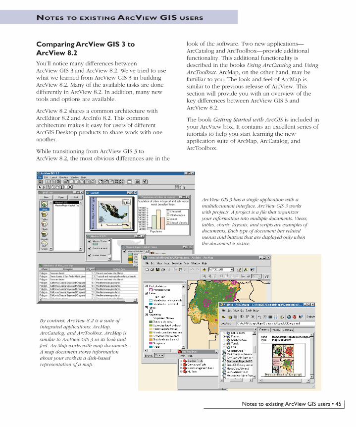
Comparing ArcView GIS 3 toArcView 8.2You’ll notice many differences betweenArcView GIS 3 and ArcView 8.2. We’ve tried to usewhat we learned from ArcView GIS 3 in buildingArcView 8.2. Many of the available tasks are donedifferently in ArcView 8.2. In addition, many newtools and options are available.
ArcView 8.2 shares a common architecture withArcEditor 8.2 and ArcInfo 8.2. This commonarchitecture makes it easy for users of differentArcGIS Desktop products to share work with oneanother.
While transitioning from ArcView GIS 3 toArcView 8.2, the most obvious differences are in the
look of the software. Two new applications—ArcCatalog and ArcToolbox—provide additionalfunctionality. This additional functionality isdescribed in the books Using ArcCatalog and UsingArcToolbox. ArcMap, on the other hand, may befamiliar to you. The look and feel of ArcMap issimilar to the previous release of ArcView. Thissection will provide you with an overview of thekey differences between ArcView GIS 3 andArcView 8.2.
The book Getting Started with ArcGIS is included inyour ArcView box. It contains an excellent series oftutorials to help you start learning the newapplication suite of ArcMap, ArcCatalog, andArcToolbox.
ArcView GIS 3 has a single application with amultidocument interface. ArcView GIS 3 workswith projects. A project is a file that organizesyour information into multiple documents. Views,tables, charts, layouts, and scripts are examples ofdocuments. Each type of document has relatedmenus and buttons that are displayed only whenthe document is active.
By contrast, ArcView 8.2 is a suite ofintegrated applications: ArcMap,ArcCatalog, and ArcToolbox. ArcMap issimilar to ArcView GIS 3 in its look andfeel. ArcMap works with map documents.A map document stores informationabout your work as a disk-basedrepresentation of a map.
Ch05.p65 04/25/2002, 11:19 AM45
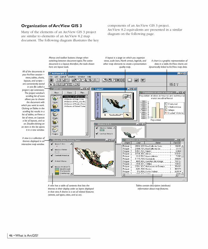
46 • What is ArcGIS?
Organization of ArcView GIS 3Many of the elements of an ArcView GIS 3 projectare similar to elements of an ArcView 8.2 mapdocument. The following diagram illustrates the key
All of the documents inyour ArcView session—
views, tables, charts,layouts, and scripts—
are conveniently storedin one file called a
project (.apr extension).The project window’sscrolling list of icons
allows you to choosethe document with
which you want to work.Clicking on Tables in thescrolling list results in alist of tables, on Views alist of views, on Layoutsa list of layouts, and soon. Double-clicking an
an item in the list opensit in a new window.
A view is a collection ofthemes displayed in an
interactive map window.
A view has a table of contents that lists thethemes in their display order as layers displayedin that view. A theme is a set of related features(streets, soil types, cities, and so on).
Tables contain descriptive (attribute)information about map features.
A layout is a page on which you organizeviews, scale bars, North arrows, legends, andother map elements to create a presentation-
quality map.
A chart is a graphic representation ofdata in a table. ArcView charts are
dynamically linked to ArcView map data.
Menus and toolbar buttons change whenswitching between document types. The activedocument is a layout; therefore, the tools shownhere are layout tools.
components of an ArcView GIS 3 project.ArcView 8.2 equivalents are presented in a similardiagram on the following page.
Ch05.p65 04/25/2002, 11:19 AM46
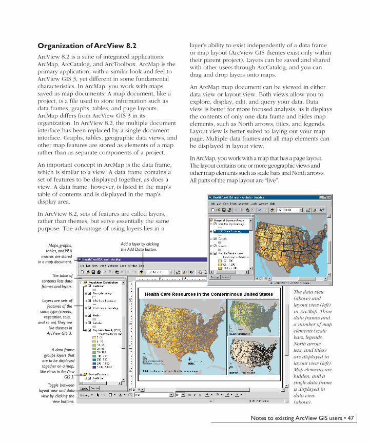
Notes to existing ArcView GIS users • 47
Organization of ArcView 8.2ArcView 8.2 is a suite of integrated applications:ArcMap, ArcCatalog, and ArcToolbox. ArcMap is theprimary application, with a similar look and feel toArcView GIS 3, yet different in some fundamentalcharacteristics. In ArcMap, you work with mapssaved as map documents. A map document, like aproject, is a file used to store information such asdata frames, graphs, tables, and page layouts.ArcMap differs from ArcView GIS 3 in itsorganization. In ArcView 8.2, the multiple documentinterface has been replaced by a single documentinterface. Graphs, tables, geographic data views, andother map features are stored as elements of a maprather than as separate components of a project.
An important concept in ArcMap is the data frame,which is similar to a view. A data frame contains aset of features to be displayed together, as does aview. A data frame, however, is listed in the map’stable of contents and is displayed in the map’sdisplay area.
In ArcView 8.2, sets of features are called layers,rather than themes, but serve essentially the samepurpose. The advantage of using layers lies in a
layer’s ability to exist independently of a data frameor map layout (ArcView GIS themes exist only withintheir parent project). Layers can be saved and sharedwith other users through ArcCatalog, and you candrag and drop layers onto maps.
An ArcMap map document can be viewed in eitherdata view or layout view. Both views allow you toexplore, display, edit, and query your data. Dataview is better for more focused analysis, as it displaysthe contents of only one data frame and hides mapelements, such as North arrows, titles, and legends.Layout view is better suited to laying out your mappage. Multiple data frames and all map elements canbe displayed in layout view.
In ArcMap, you work with a map that has a page layout.The layout contains one or more geographic views andother map elements such as scale bars and North arrows.All parts of the map layout are “live”.
Maps, graphs,tables, and VBA
macros are storedin a map document.
The table ofcontents lists dataframes and layers.
Layers are sets offeatures of the
same type (streets,vegetation, soils,
and so on). They arelike themes in
ArcView GIS 3.
A data framegroups layers that
are to be displayedtogether on a map,
like views in ArcViewGIS 3.
The data view(above) andlayout view (left)in ArcMap. Threedata frames anda number of mapelements (scalebars, legends,North arrow,text, and titles)are displayed inlayout view (left).Map elements arehidden, and asingle data frameis displayed indata view(above).
Add a layer by clickingthe Add Data button.
Toggle betweenlayout view and dataview by clicking the
view buttons.
Ch05.p65 04/25/2002, 11:19 AM47
48 • What is ArcGIS?
Tables and charts in ArcView 8.2 are similar to tablesand graphs in ArcView GIS 3, but with enhancedappearance and function.
Visual Basic for Applications has replaced Avenue™as the language used for customization and macrocreation. VBA provides a well-known standardinterface with a rich set of programming (coding anddebugging) tools.
Comparison of key conceptsMany of the terms have changed from ArcView GIS 3 toArcView 8.2. In most cases, however, equivalent featuresand functionality exist. Key concepts in ArcView GIS 3 arelisted in this section beside their equivalents inArcView 8.2. For a more extensive comparison ofconcepts, please see the online topic ‘ArcViewterminology’ in the ‘Transitioning from ArcView GIS 3to ArcView 8.2’ book of the ArcGIS Desktop Helpsystem.
Ch05.p65 04/25/2002, 11:19 AM48
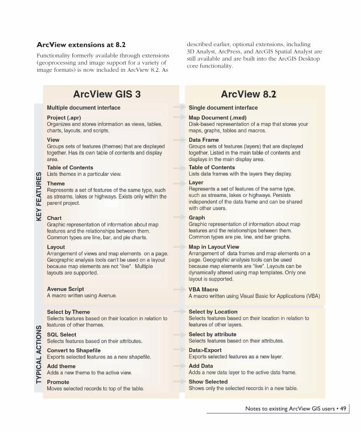
Notes to existing ArcView GIS users • 49
ArcView extensions at 8.2Functionality formerly available through extensions(geoprocessing and image support for a variety ofimage formats) is now included in ArcView 8.2. As
described earlier, optional extensions, including3D Analyst, ArcPress, and ArcGIS Spatial Analyst arestill available and are built into the ArcGIS Desktopcore functionality.
2
Ch05.p65 04/25/2002, 11:19 AM49
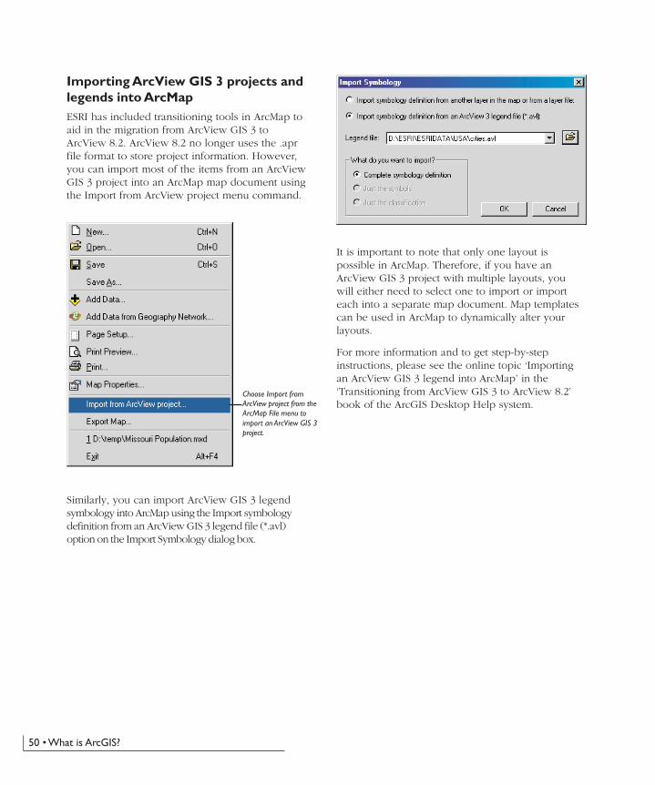
50 • What is ArcGIS?
Importing ArcView GIS 3 projects andlegends into ArcMapESRI has included transitioning tools in ArcMap toaid in the migration from ArcView GIS 3 toArcView 8.2. ArcView 8.2 no longer uses the .aprfile format to store project information. However,you can import most of the items from an ArcViewGIS 3 project into an ArcMap map document usingthe Import from ArcView project menu command.
Choose Import fromArcView project from theArcMap File menu toimport an ArcView GIS 3project.
It is important to note that only one layout ispossible in ArcMap. Therefore, if you have anArcView GIS 3 project with multiple layouts, youwill either need to select one to import or importeach into a separate map document. Map templatescan be used in ArcMap to dynamically alter yourlayouts.
For more information and to get step-by-stepinstructions, please see the online topic ‘Importingan ArcView GIS 3 legend into ArcMap’ in the‘Transitioning from ArcView GIS 3 to ArcView 8.2’book of the ArcGIS Desktop Help system.
Similarly, you can import ArcView GIS 3 legendsymbology into ArcMap using the Import symbologydefinition from an ArcView GIS 3 legend file (*.avl)option on the Import Symbology dialog box.
Ch05.p65 04/25/2002, 11:19 AM50
Notes to existing ArcView GIS users • 51
• Editing tools for constructing and editing features,creating features from existing features, and setting thesnapping environment
• Tools for importing coverages and shapefiles topersonal geodatabases or rasters to MrSID
• Tools for exporting vector layers to personalgeodatabases or rasters to TIFF, IMG, or GRID fileformat
• Tools for creating, editing, importing, and exportingmetadata as one of four metadata styles: ESRI WebStyle, FGDC FAQ Style, FGDC Report Style, and XMLData Style
• OLE containers for OLE objects inserted insideArcMap
• Industry-standard application development withVBA, VB, VC++, Delphi™, and other ActiveXlanguages
• Customization tools for extending the applicationand creating macros
• Tight integration with ArcEditor and ArcInfo
• Strong ArcIMS support
Only a few of the added features and functionality ofArcView 8.2 have been highlighted here. For a completelist of new features and functionality, please see the onlinetopic ‘New features and functionality beyondArcView GIS 3’ in the ‘Transitioning from ArcView GIS 3to ArcView 8.2’ book of the ArcGIS Desktop Helpsystem.
New features and functionality beyondArcView GIS 3Managing data with ArcCatalog and editing data with theArcMap editing tools are only two examples of the newfunctionality offered by ArcView 8.2. Improvements totools used in map interaction, map creation, dataclassification and symbolization, and map analysis are allpresented in a friendlier, Windows-based interface.
Highlights of the new features and functionality include:
• Map tips that pop up when you pause the mouse pointerover a feature, displaying an attribute of that feature
• Magnifier window that allows you to see a magnifiedview of a small area without changing the extent of yourview
• Overview window that allows you to see the full extentof the data
• Spatial bookmarks identifying particular geographiclocations at particular scales that can be saved andreferred to later
• Very rich core raster data display
• Raster georeferencing
• Advanced legend classification tools
• Multilayer data transparency that allows you to see layersunderneath transparent layers
• On-the-fly projection of features and rasters betweencoordinate systems
• Enhanced labeling capabilities including multifieldlabeling and splined labels
• Extensive collection of predefined styles forlegends, North arrows, scale bars, scale text,neatlines, and graticules
• Tool for exporting maps in a number of graphicformats (.emf, .jpg, and .pdf)
• Tool that allows you to verify SQL statementsbefore execution
Ch05.p65 04/25/2002, 11:19 AM51

Ch05.p65 04/25/2002, 11:19 AM52


![[Arcgis] Riset ArcGIS JS & Flex](https://static.fdocuments.net/doc/165x107/55cf96d7550346d0338e2017/arcgis-riset-arcgis-js-flex.jpg)


![ESRI Press, 380 New York Street, Redlands, California ...dusk.geo.orst.edu/djl/arcgis/ESRI_Press/0-front_matter.pdf · Contents Foreword Professor Jane Lubchenco [ vii] Preface [](https://static.fdocuments.net/doc/165x107/5b795d7a7f8b9a331e8da638/esri-press-380-new-york-street-redlands-california-duskgeoorstedudjlarcgisesripress0-front.jpg)