What is a traffic impact analysis? - AlexandriaVA.Gov
3
What is a traffic impact analysis? A traffic impact analysis is a study which assesses the adequacy of the existing or future transportation infrastructure to accommodate additional trips generated by a proposed development, redevelopment or land rezoning. These studies vary in their range of detail and complexity depending on the type, size and location of the development. They are important tools in assisting public agencies in making land use and planning decisions. These studies can be used to help evaluate whether the development is appropriate for a site and what type of transportation improvements may be necessary in order to maintain a satisfactory level of service. Traffic impact studies are conducted in order to: • Forecast additional traffic associated with new development • Determine the improvements that are necessary to accommodate the new development • Assist in land use decision making • Identify potential problems with the proposed development which may influence development decisions • Allow the community to assess impacts of a proposed development • Help to ensure safe and reasonable traffic conditions on streets after the development is complete • Reduce the negative impacts created by developments by helping to ensure that the transportation network can accommodate the development • Protect the substantial community investment in the street system • Recommend necessary geometric or operational improvements to the roadways In addition, large communities in particular will need to determine appropriate mixes of transportation modes, including public transit options. Community growth pat- terns and characteristics can be substantially affected by highway expansion or re- alignment decisions made at state or federal levels. Traffic impact analysis is focused on the effects of a particular set of developments, but may provide information relevant to these broader plans and decisions. Traffic impact studies should be used as one piece of several kinds of information to judge the suitability of development from a transportation standpoint. Additional information on Transportation Forecasting can be found at: http://en.wikipedia.org/wiki/Traffic_forecasting Study area of Potomac Yard Plan traffic impact analysis: City boundary to north Braddock Road to south Railway, intersection at Slaters and Wythe to the east Mt. Vernon/Commonwealth to west (see attached map for study area)
Transcript of What is a traffic impact analysis? - AlexandriaVA.Gov
What is a traffic impact analysis? A traffic impact analysis is a study which assesses the adequacy of the existing or future transportation infrastructure to accommodate additional trips generated by a proposed development, redevelopment or land rezoning. These studies vary in their range of detail and complexity depending on the type, size and location of the development. They are important tools in assisting public agencies in making land use and planning decisions. These studies can be used to help evaluate whether the development is appropriate for a site and what type of transportation improvements may be necessary in order to maintain a satisfactory level of service.
Traffic impact studies are conducted in order to:
• Forecast additional traffic associated with new development • Determine the improvements that are necessary to accommodate the new
development • Assist in land use decision making • Identify potential problems with the proposed development which may influence
development decisions • Allow the community to assess impacts of a proposed development • Help to ensure safe and reasonable traffic conditions on streets after the
development is complete • Reduce the negative impacts created by developments by helping to ensure that
the transportation network can accommodate the development • Protect the substantial community investment in the street system • Recommend necessary geometric or operational improvements to the roadways
In addition, large communities in particular will need to determine appropriate mixes of transportation modes, including public transit options. Community growth pat-terns and characteristics can be substantially affected by highway expansion or re-alignment decisions made at state or federal levels. Traffic impact analysis is focused on the effects of a particular set of developments, but may provide information relevant to these broader plans and decisions. Traffic impact studies should be used as one piece of several kinds of information to judge the suitability of development from a transportation standpoint.
Additional information on Transportation Forecasting can be found at: http://en.wikipedia.org/wiki/Traffic_forecasting
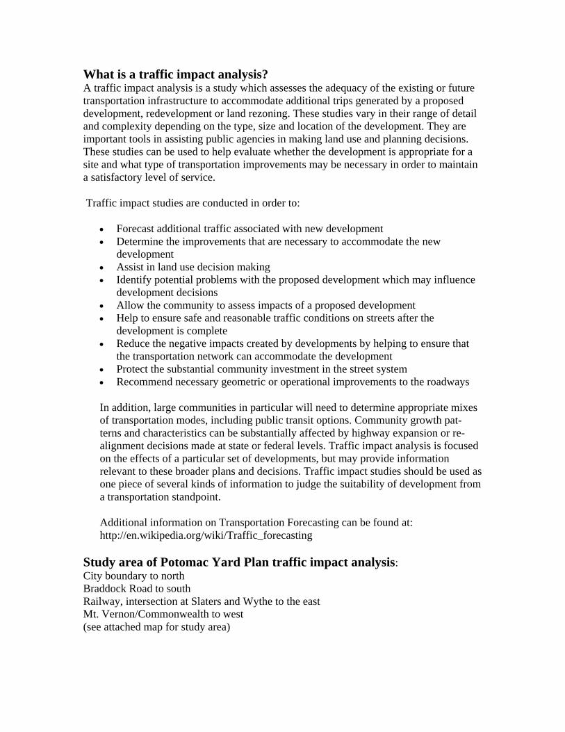
Study area of Potomac Yard Plan traffic impact analysis: City boundary to north Braddock Road to south Railway, intersection at Slaters and Wythe to the east Mt. Vernon/Commonwealth to west (see attached map for study area)

Questions to be answered by Potomac Yard traffic analysis: • How will congestion on major corridors (Route 1) compare to congestion
experienced today? • How will secondary routes (Glebe Road) handle the traffic associated with the PY
development? • How will surrounding neighborhoods be affected/protected? • What roadway improvements (in addition to BRT and Metro) will be necessary to
support proposed level of development? • How will roadway/transit improvements be phased in to support development at
each stage? • What if development occurs before BRT and Metro?/Scenarios

E. Howell Ave.E. Custis Ave.
E. Randolph Ave.
Main St. / Route 1
Commo
nweal
th Ave.
Mt. Vernon Ave.
E. Braddock Rd.
Main St. / Route 1
Monroe Ave.
Mt Ida Ave.
E. Clifford Ave.
E. Glebe Rd.
Transportation Analysis Study AreaPotomac Yard Planning Advisory Group 12.31.08
Route 1 / Driveways
Commonwealth /Mt. Vernon
Mt. Vernon / Mt. IdaMt. Vernon / Uhler
Mt. Vernon / Howell
Mt. Vernon / Monroe
Mt. Vernon / Braddock
Route 1/ E. Custis
Route 1/ Swann
Route 1/ E. Glebe / E. Clifford
Route 1/ Evans
Route 1/ Reed
Commonwealth / Glebe
Route 1/ E. Howell
Route 1/ E. Monroe
Braddock / Wythe / West
LegendStudy AreaSignalizedIntersection
Slaters / Rt. 1
Slaters / Powhatan