Wetlands and Deepwater Habitats of Saratoga County, New York
31
NATIONAL WETLANDS INVENTORY REPORT NORTHEAST REGION Wetlands and Deepwater Habitats of Saratoga County, New York: The Results of the National Wetlands Inventory March 2000
Transcript of Wetlands and Deepwater Habitats of Saratoga County, New York
NATIONAL WETLANDS INVENTORY REPORT
NORTHEAST REGION
Wetlands and Deepwater Habitats of Saratoga County, New York: The Results of the National
Wetlands Inventory
March 2000

NATIONAL WETLANDS INVENTORY REPORT
NORTHEAST REGION
Wetlands and Deepwater Habitats of Saratoga County, New York: The Results of the National
Wetlands Inventory
by
RW. Tiner, LK Huber, D.B. Foulis, T. Nuerminger, G.S. Smith, and MJ. Starr
Produced by:
u. S. Fish and Wildlife Service Ecological Services
Region 5 300 Westgate Center Drive
Hadley, MA 01035
Prepared for:
u. S. Environmental Protection Agency Region II, Water Programs
290 Broadway New York, NY 10007-1866
March 2000
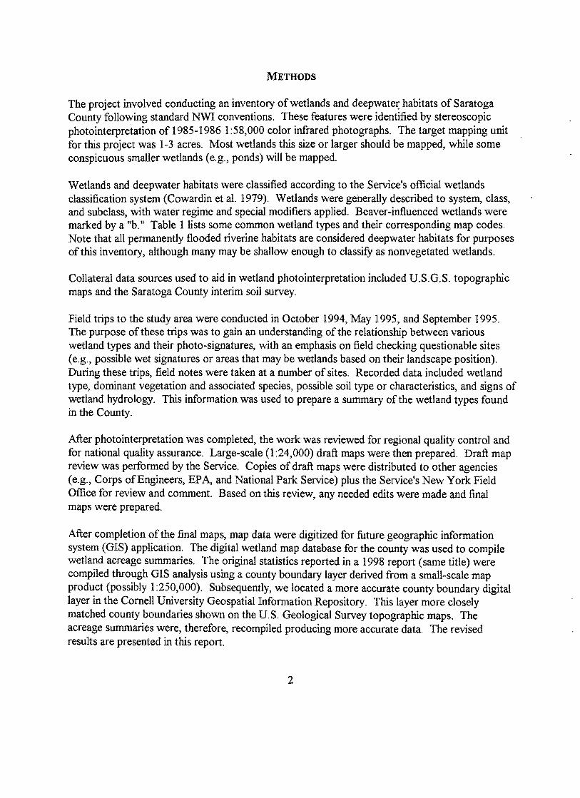
METHODS
The project involved conducting an inventory of wetlands and deepwate~ habitats of Saratoga County following standard NWI conventions. These features were identified by stereoscopic photointerpretation of 1985-1986 1 :58,000 color infrared photographs. The target mapping unit for this project was 1-3 acres. Most wetlands this size or larger should be mapped, while some conspicuous smaller wetlands (e.g., ponds) will be mapped.
Wetlands and deepwater habitats were classified according to the Service's official wetlands classification system (Cowardin et al. 1979). Wetlands were generally described to system, class, and subclass, with water regime and special modifiers applied. Beaver-influenced wetlands were marked by a lib. II Table 1 lists some common wetland types and their corresponding map codes. Note that all permanently flooded riverine habitats are considered deepwater habitats for purposes of this inventory, although many may be shallow enough to classifY as nonvegetated wetlands.
Collateral data sources used to aid in wetland photointerpretation included U.S.G.S. topographic maps and the Saratoga County interim soil survey.
Field trips to the study area were conducted in October 1994, May 1995, and September 1995. The purpose of these trips was to gain an understanding of the relationship between various wetland types and their photo-signatures, with an emphasis on field checking questionable sites (e.g., possible wet signatures or areas that may be wetlands based on their landscape position). During these trips, field notes were taken at a number of sites. Recorded data included wetland type, dominant vegetation and associated species, possible soil type or characteristics, and signs of wetland hydrology. This information was used to prepare a summary of the wetland types found in the County.
After photointerpretation was completed, the work was reviewed for regional quality control and for national quality assurance. Large-scale (1 :24,000) draft maps were then prepared. Draft map review was performed by the Service. Copies of draft maps were distributed to other agencies (e.g., Corps of Engineers, EPA, and National Park Service) plus the Service's New York Field Office for review and comment. Based on this review, any needed edits were made and final maps were prepared.
After completion of the final maps, map data were digitized for future geographic information system (GIS) application. The digital wetland map database for the county was used to compile wetland acreage summaries. The original statistics reported in a 1998 report ( same title) were compiled through GIS analysis using a county boundary layer derived from a small-scale map product (possibly 1:250,000). Subsequently, we located a more accurate county boundary digital layer in the Cornell University Geospatial Information Repository. This layer more closely matched county boundaries shown on the U. S. Geological Survey topographic maps. The acreage summaries were, therefore, recompiled producing more accurate data. The revised results are presented in this report.
2

TABLE 1. Common wetland and deepwater habitat types and their corresponding NWI map codes. Deepwater habitats are marked by an asterisk (*).
Map Code
PEMIA
PEMIC
PEMIE
PEMIF
PSSIA
PSSIC
PSSIE
PSSllEMIEb
PSS3Ba
PFOIE
PFOIC
PF02/1E
PF04E
PF05Fb
Wetland Type
Palustrine Emergent Wetland, Persistent, Temporarily Flooded
Palustrine Emergent Wetland, Persistent, Seasonally Flooded
Palustrine Emergent Wetland, Persistent, Seasonally Flooded/Saturated
Palustrine Emergent Wetland, Persistent, Semipermanently Flooded
Palustrine Scrub-Shrub Wetland, Broad-leaved Deciduous, Temporarily Flooded
Palustrine Scrub-Shrub Wetland, Broad-leaved Deciduous, Seasonally Flooded
Palustrine Scrub-Shrub Wetland, Broad-leaved Deciduous, Seasonally Flooded/Saturated
Palustrine Scrub-Shrub Wetland, Broad-leaved DeciduouslEmergent, Persistent, Seasonally Flooded/Saturated, Beaver-influenced
Palustrine Scrub-Shrub Wetland, Broad-leaved Evergreen, Saturated, Acidic
Palustrine Forested Wetland, Broad-leaved Deciduous, Seasonally Flooded/Saturated
. Palustrine Forested Wetland, Broad-leaved Deciduous, Seasonally Flooded
Palustrine Forested Wetland, Needle-leavedlBroad-leaved Deciduous, Seasonally Flooded/Saturated
Palustrine Forested Wetland, Needle-leaved Evergreen, Seasonally Flooded/Saturated
. Palustrine Forested Wetland, Dead, Semipermanently Flooded, Beaverinfluenced
3
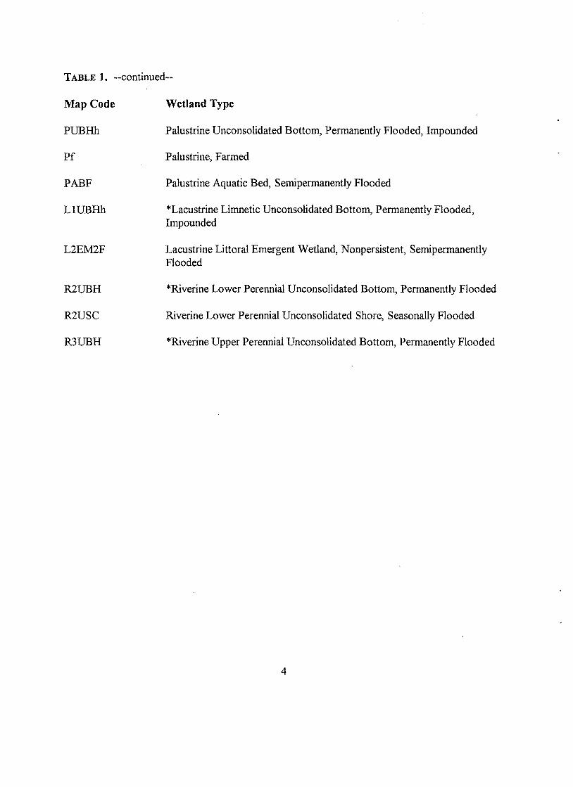
TABLE 1. --continued--
Map Code
PUBHh
Pf
PABF
LIUBHh
L2EM2F
R2UBH
R2USC
R3UBH
Wetland Type
Palustrine Unconsolidated Bottom, Permanently Flooded, Impounded
Palustrine, Farmed
Palustrine Aquatic Bed, Semipermanently Flooded
*Lacustrine Limnetic Unconsolidated Bottom, Permanently Flooded, Impounded
Lacustrine Littoral Emergent Wetland, Nonpersistent, Semipermanently Flooded
*Riverine Lower Perennial Unconsolidated Bottom, Permanently Flooded
Riverine Lower Perennial Unconsolidated Shore, Seasonally Flooded
*Riverine Upper Perennial Unconsolidated Bottom, Permanently Flooded
4
RESULTS
Wetland Plant Communities
The study area contained freshwater wetlands of varying types. Most of the wetlands were vegetated types represented by forested wetlands, scrub-shrub wetlands, emergent wetlands, and various mixtures of these types. Nonvegetated wetlands also were common. These wetlands were mostly comprised of farm ponds. Wetland plants can be identified by the specialized field guides, such as "Field Guide to Nontidal Wetland Identification" (Tiner 1988) and "In Search of Swampland: A Wetland Sourcebook and Field Guide" (Tiner 1998), or by more technical taxonomic manuals (e.g., Fernald 1950).
Common emergent wetland species included the following: tussock sedge (Carex stricta), purple loosestrife (Lythrum salicaria), broad-leaved cattail (Typha latifolia), big arrowhead (Sagittaria latifolia), eastern bur-reed (Sparganium americanum), reed canary grass ~halaris arundinacea), soft rush (Juncus effusus), sweet flag (Acorus calamus), and sensitive fern (Onoclea sensibilis). Other emergents observed were arrow arum ~eltandra virginica) and soft-stemmed bulrush (Scirpus validus).
Some aquatic bed species seen during the inventory were white water lily (Nymphaea odorata), water milfoil (Myriophyllum sp.), duckweed (Lemnacea), and water chestnut (Trapa natans). The latter species was observed on a state wildlife management area along the Mohawk River (Erie Canal) near Vischer Ferry.
Shrub wetlands were represented by the following species: speckled alder (Alnus rugosa), red osier dogwood (Comus stolonifera), common elderberry (Sambucus canadensis), northern arrowwood (Viburnum recognitum), broad-leaved meadowsweet (Spiraea latifolia), northern wild raisin (Yiburnum cassinoides), tartarian honeysuckle (Lonicera tartarica), silky dogwood (Comus amomum), and swamp rose (Rosa palustris). Saplings of several tree species were also found in shrub wetlands such as black willow (Salix nigra) and red maple (Acer rubrum).
Several species were dominant or common trees in forested wetlands in Saratoga County. Common deciduous species were red maple, green ash Q:raxinus pennsylvanica), black gum (Nyssa sylvatica), trembling aspen (Populus tremuloides), eastern cottonwood ~opulus deltoides), box elder (Acer negundo), black willow, American elm (Wmus americana), and swamp white oak (Quercus bicolor). Larch or tamarack (Larix laricina) also occurred and co-dominated some sites. Two evergreens were frequently observed eastern white pine ~inus strobus) and eastern hemlock (Tsuga canadensis). The former was often co-dominant with red maple in mixed forested wetlands. Balsam fir (Abies balsamea) was uncommon. Typical shrubs found in forested wetlands included speckled alder, broad-leaved meadowsweet, common winterberry alex verticillata), gray birch (Hetula populifolia), northern arrowwood, northern wild raisin, gray dogwood (Comus racemosa), tartarian honeysuckle, highbush blueberry (Vaccinium corymbosum), and silky dogwood. Emergent species included some ferns (cinnamon - Osmunda
5
cinnamomea, royal - O. regalis, sensitive, and marsh - Thelypteris thelypteroides), manna-grasses (Glyceria striata; G. canadensis), jewelweed (Impatiens capensis), skunk cabbage (Symplocarpus foetidus), marsh horsetail @quisetum fluviatile), mayflower (Maianthemum canadense), goldthread (Coptis groenlandica), and several sedges (including tussock, fringed - Carex crinit~ and bladder - C. intumescens). Examples of some forested wetland communities are given in Table 2.
6

TABLE 2. Examples of palustrine forested wetland (PFO) plant communities in Saratoga County, New York. [Codes: 1 - broad-leaved deciduous, 2 - needle-leaved deciduous, 4 - needle-leaved evergreen, B -saturated (seasonally), C - seasonally flooded, E - seasonally flooded/saturated, and h - impounded.]
Wetland Type Dominant Species (Map Code)
PFOIE Acer rubrumIFraxinus pennsylvanica
PFO IB Acer rubrum
PFOIC
PFOIA
PFOICh
PFOIA
Acer rubrum
Acer rubrumIFraxinus sp.
Populus deltoidesl Acer negundo
Acer rubrum
Associated Species
Alnus rugosa, Spiraea latifolia, Osmunda regalis, Onoclea sensibilis, Equisetum fluviatile, Thelypteris thelypteroides, Glyceria canadensis, Betula populifolia, Osmunda cinnamomea, Fragaria virginiana, Impatiens capensis, Galium sp., Carex crinita, Juncus effusus, Carex stricta, Eupatoriadelphus sp., Leersia sp.
Onoc1ea sensibilis, Osmunda cinnamomea, Sphagnum sp., Viburnum recognitum, Carex sp., Alnus rugosa, Tsuga canadensis, Viburnum cassinoides, Carex crinita, Geum sp., Galium sp., Osmunda regalis, Carpinus caroliniana, Ulmus americana
Nyssa sylvatica, Fraxinus pennsylvanica, Viburnum recognitum, Osmunda cinnamomea, Impatiens capensis, Vaccinium corymbosum, Pinus strobus, Corylus americana, Maianthemum canadensis, Symplocarpus foetidus, Viburnum cassinoides, Hex verticillata, Aralia nudicaulis, Arisaema atrorubens, Thelypteris noveboracensis, Quercus alba
Viburnum recognitum, Osmunda cinnamomea, Onoclea sensibilis, Populus tremuloides, Betula populifolia, Pinus strobus, Viburnum cassinoides, Alnus rugosa, Symplocarpus foetidus
Salix nigra, Ulmus americana, Onoc1ea sensibilis, Impatiens capensis, Solidago sp., Vitis sp., Cinna arundinacea, Urtica dioica
Onoclea sensibilis, Comus foemina, Osmunda cinnamomea, Ulmus americana, Betula populifolia, Populus tremuloides, Prunus serotina, Spiraea latifolia, Vitis sp.
7
TABLE 2. --continued--
Wetland Type Dominant Species
PFO IE Acer rubrum
PFO IE Acer rubrurnlFraxinus pennsylvanica
PFOIC Fraxinus pennsylvanica! Populus deltoides
PF0211 C Larix laricina!Salix nigra! Populus deltoides
PFO IE Fraxinus pennsylvanica
PFO 1I4B Acer rubrurnlPinus strobus
PF01l4B Acer rubrurnlPinus strobus
PF04E Pinus strobus/Tsuga canadensis
Associated Species
Ulmus americana, Quercus bicolor, Viburnum recognitum, Onoc1ea sensibilis, Osmunda cinnamomea, Pinus strobus
Ilex verticillata, Alnus rugosa, Osmunda regalis, Carex stricta, Thelypteris thelypteroides, Decodon verticillatus, Onoclea sensibilis, Osmunda cinnamomea, Lythrum salicaria, Peltandra virginica, Sagittaria latifolia, Utricularia sp.
Salix nigra, Equisetum fluviatile, Osmunda cinnamomea, Solidago sp., Onoclea sensibilis, Ulmus americana, Urtica diocia, Impatiens capensis, Apios sp., Galium sp., Parthenocissis quinquefolia, Echinocystis lobata, Comus amomum, Acer negundo
Comus foemina, Solidago sp., Onoc1ea sensibilis, Vitis sp., Acer rubrum, Aster sp., Crataegus sp., Fragaria virginiana, Phragmites australis, Asclepias sp., Glyceria striata
Salix nigra, Carex sp., Lonicera tartarica, Solidago sp., Lythrum salicaria
Osmunda cinnamomea, Onoc1ea sensibilis, Solidago sp., Vaccinium corymbosum, Fraxinus sp., Carex crinita, Salix sp.
Fraxinus sp., Viburnum recognitum, Osmunda cinnamomea, Onoclea sensibilis, Coptis groenlandica, Rubus hispidus, Viburnum cassinoides, Prunus serotina, Maianthemum canadense, Tsuga canadensis, Osmunda regalis, Hex verticillata, Populus tremuloides, Comus amomum, Carex intumescens, Alnus rugosa, Ulmus amencana
Viburnum cassinoides, Osmunda cinnamomea, Onoclea sensibilis, Acer rubrum, Sphagnum sp., Abies balsamea,
Fraxinus pennsylvanica, Alnus rugosa
8
Wetland Maps and Digital Geospatial Data
Twenty-seven 1:24,000 National Wetlands Inventory (NWI) maps were prepared using U.S. Geological Survey topographic maps as the base maps. These maps may be ordered by calling the NWI state map distribution center: Institute for Resource Information Systems (IRIS) at Cornell University, Ithaca, 607-255-4864.
All NWl maps have been digitized for GIS applications. Digital data are accessible through the Internet: http://www.nwi.fws.govlhomepage.
Wetland and Deepwater Habitat Acreage Summaries
County Totals
According to the NWl, Saratoga County possessed 42,801 acres of wetlands and 20,954 acres of deepwater habitats. Wetlands alone accounted for about 8 percent of the county, while deepwater habitats occupied about 4 percent of the County's land area. Most of Saratoga County was represented by uplands (88%).
Palustrine wetlands were the most abundant types, accounting for 42,680 acres (99.7 percent of the County's wetlands). Only 118 acres oflacustrine wetlands and 3 acres of riverine wetlands were inventoried. Table 3 summarizes wetland acreage for the County, while raw data are included as Appendix A.
Palustrine forested wetlands predominated, occupying over 30,800 acres and representing 72 percent of~Saratoga County's wetlands. Broad-leaved deciduous forested wetlands were the most abundant type (13,632 acres), with mixed forested and shrub wetlands (mostly deciduous) second-ranked in abundance (6091 acres). Emergent wetlands and scrub-shrub wetlands were present in nearly equal amounts (3,328 acres and 3,125 acres, respectively) and representing 8 and 7 percent of the County's wetlands, respectively. Mixtures of emergent-shrub wetlands comprised about 6 percent of the County total (or 2,579 acres). Eighty-nine acres offarmed wetlands were inventoried. Shallow water, mostly nonvegetated wetlands (riverine and lacustrine wetlands plus palustrine nonvegetated wetlands) accounted for 7 percent of the County's wetlands (or 2,852 acres).
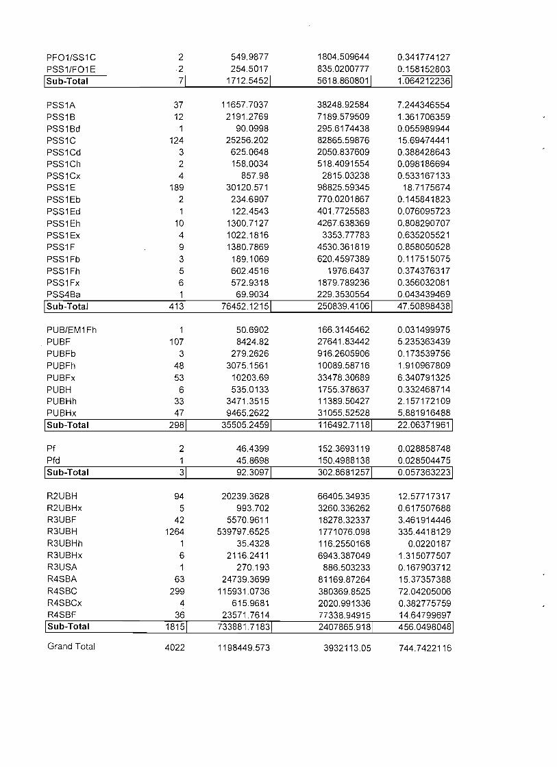
Statistics for linear wetlands (too small to map as polygons) were recorded in miles. Over 280 miles of these linear features were mapped: 1) 161 miles of linear palustrine forested wetlands; 2) 57 miles of linear emergent wetlands; 3) 48 miles oflinear palustrine scrub-shrub wetlands; and 4) 22 miles of linear ponds (including large ditches). Most of the vegetated linears followed narrow drainageways (e.g., hillside seeps and swales) (see Appendix B for raw data).
A total of20,954 acres of deepwater habitats were mapped in the County. Lakes and reservoirs predominated with 15,458 acres inventoried. These waterbodies represented 74 percent of the
9
County's deepwater habitats. The remaining 26 percent were riverine wetlands (5,496 acres mapped: 4,878 acres oflower perennial rivers and streams; 618 acres of upper perennial streams). In addition, over 450 miles oflinear riverine wetlands were mapped. Nearly three-quarters of these features were upper perennial streams (340 miles), while 103 miles of intermittent streambeds and 13 miles of linear lower perennial streams were also inventoried.-
Town Totals
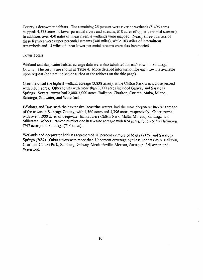
Wetland and deepwater habitat acreage data were also tabulated for each town in Saratoga County. The results are shown in Table 4. More detailed information for each town is available upon request (contact the senior author at the address on the title page).
Greenfield had the highest wetland acreage (3,838 acres), while Clifton Park was a close second with 3,811 acres. Other towns with more than 3,000 acres included Galway and Saratoga Springs. Several towns had 2,000-3,000 acres: Ballston, Charlton, Corinth, Malta, Milton, Saratoga, Stillwater, and Waterford.
Edinburg and Day, with their extensive lacustrine waters, had the most deepwater habitat acreage of the towns in Saratoga County, with 4,360 acres and 3,396 acres, respectively. Other towns with over 1,000 acres of deepwater habitat were Clifton Park, Malta, Moreau, Saratoga, and Stillwater. Moreau ranked number one in riverine acreage with 824 acres, followed by Halfinoon (747 acres) and Saratoga (714 acres).
Wetlands and deepwater habitats represented 20 percent or more of Malta (24%) and Saratoga Springs (20%). Other towns with more than 10 percent coverage by these habitats were Ballston, Charlton, Clifton Park, Edinburg, Galway, Mechanicville, Moreau, Saratoga, Stillwater, and Waterford.
10

, TABLE 3. Acreage summary of wetlands in Saratoga County, New York based on NWI mapping.
Palustrine Wetlands Emergent Mixed Emergent/Shrub Scrub-shrub
Broad-leaved Deciduous Broad-leaved Evergreen Needle-leaved Evergreen Mixed Subtotal
Forested Broad-leaved Deciduous Mixed Deciduous (Broad- and Needle-leaved)
Needle-leaved Evergreen Mixed DeciduouslEvergreen Mixed Forested/Shrub Mixed ForestedlEmergent Dead Subtotal
Unconsolidated Bottom Nonvegetated Mixed wlEmergent Mixed w/Shrub Mixed wlDead Trees Aquatic Bed Subtotal
Unconsolidated Shore Farmed
Subtotal Palustrine Wetlands
Riverine Wetlands Lacustrine Wetlands
Nonvegetated (Unconsolidated Bottom) Emergent Aquatic Bed Subtotal Lacustrine Wetlands
All Wetlands
11
Acreage 3,328.2 2,579.1
3,006.2 43.1 17.6 58.1
3,125.0
13,631.8
77.3 1,949.2 8,237.2 6,090.9
317.1 523.8
30,827.3.
1,948.8 338.4 234.0 175.6 13.3
2,710.1 21.2 89.0
42,679.9
3.4
42.5 26.9 48.1
117.5
42,800.8
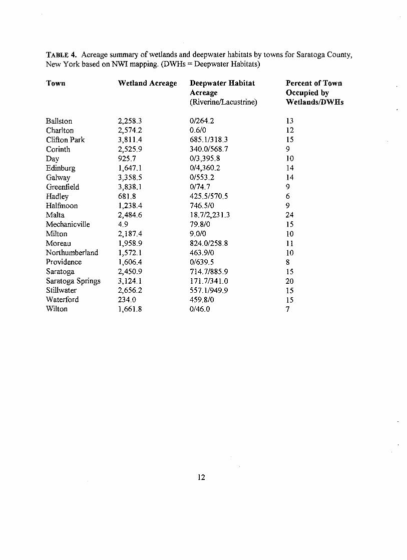
TABLE 4. Acreage summary of wetlands and deepwater habitats by towns for Saratoga County, New York based on NWI mapping. (DWHs = Deepwater Habitats)
Town Wetland Acreage Deepwater Habitat Percent of Town Acreage Occupied by (Riverine/Lacustrine) WetlandsIDWHs
Ballston 2,258.3 0/264.2 13 Charlton 2,574.2 0.6/0 12 Clifton Park 3,811.4 685.11318.3 15 Corinth 2,525.9 340.01568.7 9 Day 925.7 0/3,395.8 10 Edinburg 1,647.1 0/4,360.2 14 Galway 3,358.5 01553.2 14 Greenfield 3,838.1 0174.7 9 Hadley 681.8 425.51570.5 6 Halfmoon 1,238.4 746.510 9 Malta 2,484.6 18.7/2,231.3 24 Mechanicville 4.9 79.8/0 15 Milton 2,187.4 9.010 10 Moreau 1,958.9 824.0/258.8 11 Northumberland 1,572.1 463.9/0 10 Providence 1,606.4 0/639.5 8 Saratoga 2,450.9 714.7/885.9 15 Saratoga Springs 3,124.1 171.71341.0 20 Stillwater 2,656.2 557.11949.9 15 Waterford 234.0 459.8/0 15 Wilton 1,661.8 0/46.0 7
12
ACKNOWLEDGMENTS
The authors wish to express their thanks to several individuals for contributing to the completion of this project. First, this project would not have been possible without funding support from the U.S. Environmental Protection Agency and the National Park Service. Funding from these agencies were combined with Service funds to produce a complete inventory (maps, statistics, digital database, and report) for Saratoga County. The support of EPA was particularly noteworthy as it saw the need for this information to aid local planners in developing a wetland protection strategy for the county. The efforts of Dan Montella toward this end are gratefully acknowledged.
Photointerpretation for this project was performed by staff of the Natural Resources Assessment Group in the Department of Plant and Soil Sciences at the University of Massachusetts-Amherst. This Group is under the direction of De Peter Veneman whose support (technical and administrative), we greatly appreciate. Photointerpreters for this project included Irene Huber, David Foulis, and Todd Nuerminger, with Ms. Huber doing the bulk of the work.
Glenn Smith of the U. S. Fish and Wildlife Service performed quality control of the interpreted photos and assisted in field review of draft maps. Ralph Tiner, Regional Wetland Coordinator for the Service, managed the project for the Service, assisted in field data collection, and prepared the final report. The Service's NWI Office in St. Petersburg, Florida was responsible for wetland map production and digital database construction. Special thanks go to Becky Stanley ( data prep), Greg Pipkin (national quality control and map production), Kurt Snider (digital database construction), and Matthew Starr (data analysis).
Other individuals also assisted in various phases of this project. Tim Post (New York Department of Environmental Conservation) and Chris Martin and Jim Schaberl (National Park Service) assisted in the field review. Mark Silverman of the U.S.D.A. Natural Resources Conservation Service provided "Interim Soil Survey Report for Saratoga County" for our use.
13
REFERENCES
Cowardin, L.M., V. Carter, F.C. Golet, and E.T. LaRoe. 1979. Classification of Wetlands and Deepwater Habitats of the United States. US. Fish and Wildlife Service, Washington, DC. FWS/OBS-79/31.
Fernald, M.L. 1970. Gray's Manual of Botany. Van Nostrand Reinhold Company, New York, NY.
Tiner, RW. 1988. Field Guide to Nontidal Wetland Identification. US. Fish and Wildlife Service, Newton Comer, MA, and Maryland Dept. of Natural Resources, Annapolis, MD. Reprinted by the Institute for Wetland & Environmental Education & Research, P.O. Box 288, Leverett, MA 01054.
Tiner, RW. 1998. In Search of Swampland: A Wetland Sourcebook and Field Guide. Rutgers University Press, P.O. Box 5062, New Brunswick, Nr08903.
14

ApPENDIX A. Raw digital data summaries of wetland and deepwater habitat polygons appearing on NWI maps for Saratoga County, New York. .

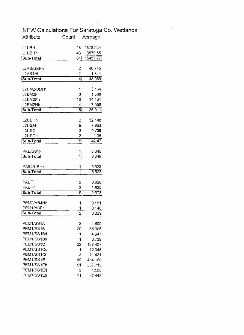
NEW Calculations For Saratoga Co. Wetlands Attribute Count Acreage
L 1UBH 18 1578.224 L 1 UBHh 43 13879.55
!Sub-Total 61! 15457.77!
L2AB/UBHh 2 46.745 L2AB4Hh 2 1.341
!Sub-Total 41 48.0861
L2EM2/UBFh 1 3.164 L2EM2F 3 1.588 L2EM2Fh 10 14.161 L2EM2Hh 4 7.998
1 Sub-Total 181 26.9111
L2UBHh 2 32.448 L2USAh 9 7.963 L2USC 2 0.709 L2USCh 2 1.35
ISub-Total 151 42.471
PAB/SS1 F 1 0.349 ISub-Total 11 0.3491
PAB5/UBHx 1 5.523 1 Sub-Total 11 5.5231
PABF 2 0.838 PABHh 3 1.835
1 Sub-Total 51 2.6731
PEM2/AB4Hh 1 0.181 PEM1/ABFh 1 0.148
1 Sub-Total 21 0.3291
PEM1/SS1A 2 4.609 PEM1/SS1B 20 66.306 PEM1/SS1 Bd 1 4.947 PEM1/SS1Bh 1 0.739 PEM1/SS1C 22 123.407 PEM1/SS1Cd 1 12.045 PEM1/SS1Ch 3 11.431 PEM1/SS1 E 99 434.188 PEM1/SS1Eb 51 337.713 PEM1/SS1Ed 3 12.05 PEM1/SS1 Eh 11 37.443
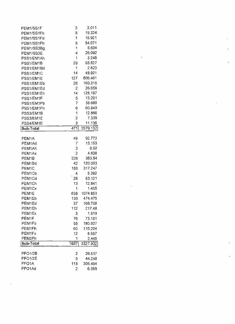
PEM1/SS1F 3 2.011
PEM1/SS1Fb 5 19.324
PEM1/SS1Fd 1 15.921
PEM1/SS1Fh 5 54.071
PEM1/SS3Bg 1 5.604
PEM1/SS3E 4 26.092
PSS1/EM1Ah 1 3.248
PSS1/EM1B 29 93.827
PSS1/EM1Bd 1 2.623
PSS1/EM1C 14 45.921
PSS1/EM1 E 127 806.461
PSS1/EM1Eb 26 160.215
PSS1/EM1Ed 2 26.659
PSS1/EM1Eh 14 128.197
PSS1/EM1F 5 13.201
PSS1/EM1Fb 7 38.689
PSS1/EM1Fh 6 60.849
PSS3/EM1B 1 12.866
PSS3/EIVI1 E 2 7.339
PSS4/EM1E 3 11.136
I Sub-Total 4711 2579.1321
PEM1A 49 92.773 PEM1Ad 7 13.153 PEM1Ah 3 0.92 PEM1Ax 2 4.838 PEM1B 226 363.54 PEM1Bd 42 120.003 PEM1C 188 317.247 PEM1Cb 4 5.392 PEM1Cd 28 83.121 PEM1Ch . 13 12.841 PEM1Cx 1 1.455 PEM1E 638 1074.853 PEM1Eb 130 474.475 PEM1Ed 37 168.708 PEM1Eh 112 217.48 PEM1Ex 3 1.819 PEM1F 76 73.181 PEM1Fb 55 180.927 PEM1 Fh 60 110.204 PEM1Fx 12 8.557 PEM2Fh 1 2.445
1 Sub-Total 16871 3327.9321
PF01/2B 2 26.517 PF01/2E 5 44.248 PF01A 118 305.494 PF01Ad 2 6.595

PF01Ah 15 54.116 PF01B 209 923.169 PF01Bb 2 2.912 PF01 Bd 15.453 PF01C 431 1859.336 PF01Cb 9 19.484 PF01Cd 4 36.507 PF01Ch 116 517.446 PF01E 1494 8905.412 PF01Eb 65 291.223 PF01Ed 15 114.156 PF01Eh 80 580.436 PF02/1E 2 6.564
1 Sub-Total 25701 13709.071
PF01/4A 5 30.021 PF01/4B 121 1572.887 PF01/4Bb 8.844 PF01/4C 21 171.353 PF01/4Cb 1 0.86 PF01/4Ch 3 5.75 PF01l4E 408 4814.422 PF01/4Eb 12 91.764 PF01/4Eh 1 2.287 PF01/5Eb 3 45.75 PF01/5Fb 2 3.222 PF04/1 B 23 256.358 PF04/1C 2 16.864 PF04/1 E 119 1114.095 PF04/1Eb 9 97.788 PF04/1Eh 1 1.144 PF04/5Eb 2 3.816
1 Sub-Total 7341 8237.2251
PF04A 2 13.334 PF04B 50 267.232 PF04Ba 2 14.836 PF04C 4 5.577 PF04Cb 3 8.32 PF04E 376 1378.656 PF04Eb 34 238.531 PF04Ed 1 11.243 PF04Eh 4 9.852 PF04Fb 1 1.579
ISub-Total 4771 1949.161
PF05/1Eb 1 19.198 PF05/1Fb 1 2.923
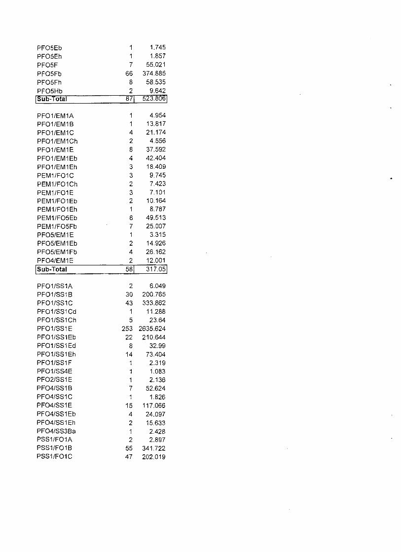
PF05Eb 1.745 PF05Eh 1 1.857
PF05F 7 55.021
PF05Fb 66 374.885 PF05Fh 8 58.535 PF05Hb 2 9.642 I Sub-Total 871 523.8061
PF01/EM1A 4.954 PF01/EM1B 1 13.817 PF01/EM1C 4 21.174 PF01/EM1Ch 2 4.556 PF01/EM1E 8 37.592 PF01/EM1Eb 4 42.404 .
PF01/EM1Eh 3 18.409 PEM1/F01C 3 9.745 PEM1/F01Ch 2 7.423 PEM1/F01E 3 7.101 PEM1/F01Eb 2 10.164 PEM1/F01Eh 1 8.787 PEM1/F05Eb 8 49.513 PEM1/F05Fb 7 25.007 PF05/EM1 E 1 3.315 PF05/EM'1 Eb 2 14.926 PF05/EM1Fb 4 26.162 PF04/EM1E 2 12.001
ISub-Total 581 317.051
PF01/SS1A 2 6.049 PF01/SS1B 30 200.765 PF01/SS1C 43 333.862 PF01/SS1Cd 1 11.288 PF01/SS1Ch 5 23.64 PF01/SS'i E 253 2635.624 PF01/SS1Eb 22 210.644 PF01/SS1Ed 8 32.99 PF01/SS1Eh 14 73.404 PF01/SS1F 1 2.319 PF01/SS4E 1 1.083 PF02/SS1 E 1 2.136 PF04/SS1B 7 52.624 PF04/SS1C 1 1.826 PF04/SS1E 15 117.066 PF04/SS1Eb 4 24.097 PF04/SS1Eh 2 15.633 PF04/SS3Ba 1 2.428 PSS1/F01A 2 2.897 PSS1/F01B 55 341.722 PSS1/F01C 47 202.019
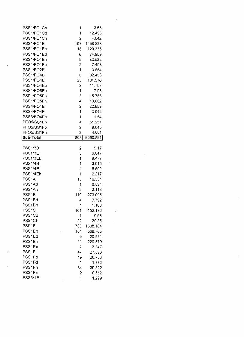
PSS1/F01Cb 3.68 PSS1/F01Cd 12.493 PSS1/F01Ch 2 4.042 PSS1/F01 E 197 1258.828 PSS1/F01 Eb 18 120.336 PSS1/FO'1 Ed 6 74.909 PSS1/F01Eh 9 33.522 PSS1/F01 Fb 2 7.403 PSS1/F02E 3.654 PSS1/F04B 8 32.453 PSS1/F04E 23 . 104.576 PSS1/F04Eb 2 11.702 PSS1/F05Eb 7.08 PSS1/F05Fb 3 15.783 PSS1/F05Fh 4 13.082 PSS4/FO'IE 2 22.653 PSS4/F04E 1 3.942 PSS3/F04Eb 1.54 PF05/SS1Eb 4 51.251 PF05/SS1Fb 2 9.845 PF05/SS1Fh 2 4.001
ISub-Total 8051 6090.8911
PSS1/3B 2 9.17 PSS1/3E 3 6.647 PSS1/3Eb 8.477 PSS1/4B 3.015 PSS1/4E 4 8.692 PSS1/4Eh 1 2.217 PSS1A 13 16.534 PSS1Ad 1 0.534 PSS1Ah 2 2.113 PSS'IB 110 273.095 PSS1Bd 4 7.792 PSS1Bh 1 1.103 PSS1C 101 152.176 PSS1Cd 1 0.68 PSS1Ch 22 20.35 PSS1E 738 1638.184 PSS1Eb 104 568.705 PSS1Ed 6 20.931 PSS1Eh 91 229.379 PSS'IEx 2 2.347 PSS1F 47 27.893 PSS1Fb 19 26.736 PSS1Fd 1 1.382 PSS1Fh 34 30.522 PSS1Fx 2 0.552 PSS3/1 E 1.299
PSS3/4Bg 1 0.963 PSS3B 1 0.424 PSS3Ba 10 35.526
PSS3E 2 0.739 PSS3Eh 0.537 PSS4/1E 1 6.017 PSS4/1Eb 1 2.6 PSS4B 1 0.307 PSS4E 8 12.61 PSS4Eb 1 4.718
\ Sub-Total 1339\ 3124.966\
PUB/ABFh 2 1.755 PUB/ABHh 4 2.767 PUB/ABHx 1 0.409
\ SUb-Total 7\ 4.9311
PUB/EM1Eb 1 2.593 PUB/EM1Eh 1 0.981 PUB/EM1 F 9 4.187 PUB/EM1Fb 21 81.149 PUB/EM1Fh 38 130.095 PUB/EM1Fx 3 0.623 PUB/EM1Hh 1 14.135 PUB/EM2Fh 4 32.062 PUB/EM2H 1 12.604 PLiB/EM2Hh 1.179 PEM2/UBFh 1 3.054 PEM2/UBHh 2 3.243 PEM/UBF 1 0.259 PEM1/UBF 5 2.229 PEM1/UBFb 8 24.962 PEM1/UBFh 12 24.779 PEM1/UBFx 2 0.284
\ Sub-Total 1111 338.418\
PUB/F01F 1 0.783 PUB/F05Fb 22 114.56 PUB/F05Fh 4 12.82 PUB/F05Hb 1 14.945 PUB/F05Hh 1 4.83 PF05/UBFb 7 24.4 PF05/UBFh 1 3.258 I SUb-Total 37\ 175.5961
PUB/SS'IF 12 20.57 PUB/SS1Fb 19 68.372 PUB/SS1Fh 21 41.051 PUB/SS1Fx 2 2.594

PSS1/UBF 8 21.87 PSS1/UBFb 6 59.646 PSS1/UBFh 9 19,894
1 Sub-Total 771 233.9971
PUBF 162 61.121 PUBFb 222 296.83 PUBFh 246 137.629 PUBFx 75 37.865 PUBH 82 232.432 PUBHb 8 57.981 PUBHh 1192 1032.499 PUBHx 142 89.226 PUBKh 1 0.894 PUBKx 6 2.42 PUSAh 2 4.572 PUSAx 8 8.095 PUSC 1 0.318 PUSCh 7 5.052 PUSCx 9 3.107
1 Sub-Total 21631 1970.0411
Pf 12 40.991 Pfd 5 32.086 Pfh 4 15.909 ISub~Total 211 88.9861
R2UBH 9 4878.197 R2USA 1 0,215 R2USC 2 2.935 R3UBH 12 618,172 R3USA 1 0.258
1 Sub-Total 251 5499.7771
Wetland Sub total 10776 63755.09
Upland 633 475897.4
Grand Total 11409 539652.5


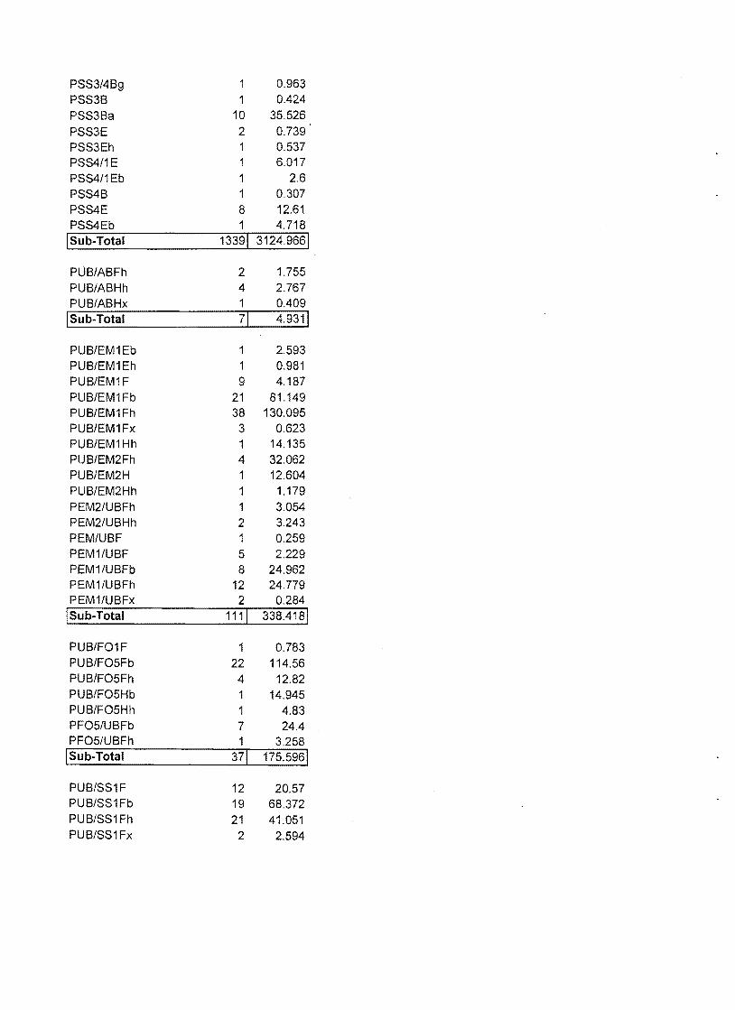
ApPENDIX B. Raw digital data summaries for linear wetlands based on NWI mapping for Saratoga County, New York. .

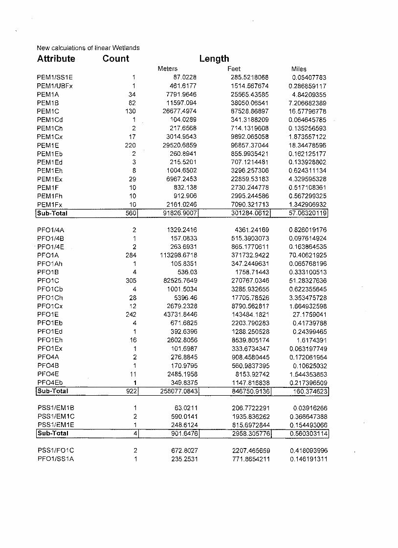
New calculations of linear Wetlands
Attribute Count Length Meters Feet Miles
PEM1/SS1E 1 87.0228 285.5218068 0.05407783 PEM1/UBFx 1 461.6177 1514.567674 0.286859117 PEM1A 34 7791.9646 25565.43585 4.84209355 PEM1B 82 11597.094 38050.06541 7.206682389 PEM1C 130 26677.4974 87528.86897 16.57796778 PEM1Cd 1 104.0289 341.3188209 0.064645785 PEM1Ch 2 217.6568 714.1319608 0.135256593 PEM1Cx 17 3014.9543 9892.065058 1.873557122 PEM1E 220 29520.6859 96857.37044 18.34478596 PEM1 Eb 2 260.8941 855.9935421 0.162125177 PEM1Ed 3 215.5201 707.1214481 0.133928802 PEM1Eh 8 1004.6502 3296.257306 0.624311134 PEM1Ex 29 6967.2453 22859.53183 4.329595328 PEM1F 10 832.138 2730.244778 0.517108361 PEM1Fh 10 912.906 2995.244586 0.567299325 PEM1Fx 10 2161.0246 7090.321713 1.342906932
1 Sub-Total 5601 91826.90071 301284.06121 57.063201191
PF01/4A 2 1329.2416 4361.24169 0.826019176 PF01/4B 1 157.0833 515.3903073 0.097614924
. PF01/4E 2 263.6931 865.1770611 0.163864535 PF01A 284 113298.6718 371732.9422 70.40621925 PF01Ah 1 105.8351 347.2449631 0.065768196 PF01B 4 536.03 1758.71443 0.333100513 PF01C 305 82525.7649 270767.0346 51.28327636 PF01Cb 4 1001.5034 3285.932655 0.622355645 PF01Ch 28 5396.46 17705.78526 3.353475728 PF01Cx 12 2679.2328 8790.562817 1.664932598 PF01E 242 43731.8446 143484.1821 27.1759041 PF01Eb 4 671.6825 2203.790283 0.41739788 PF01Ed 1 392.6396 1288.250528 0.24399465 PF01Eh 16 2602.8056 8539.805174 1.6174391 PF01 Ex 1 101.6987 333.6734347 0.063197749 PF04A 2 276.8845 908.4580445 0.172061954 PF04B 1 170.9795 560.9837395 0.10625032 PF04E 11 2485.1958 8153.92742 1.544353853 PF04Eb 1 349.8375 1147.816838 0.217396509
ISub-Total 9221 258077.08431 846750.91361 160.3746231
PSS1/EM1 B 1 63.0211 206.7722291 0.03916266 PSS1/EM1C 2 590.0141 1935.836262 0.366647388 PSS1/EM1E 1 248.6124 815.6972844 0.154493066
ISub-Total 41 901.64761 2958.3057761 0.5603031141
PSS1/F01C 2 672.8027 2207.465659 0.418093996 PF01/SS1A 1 235.2531 771.8654211 0.146191311
PF01/SS1C 2 549.9877 1804.509644 0.341774127 PSS1/F01 E 2 254.5017 835.0200777 0.158152803
ISub-Total 71 1712.54521 5618.8608011 1.0642122361
PSS1A 37 11657.7037 38248.92584 7.244346554 PSS1B 12 2191.2769 7189.579509 1.361706359 PSS1Bd 1 90.0998 295.6174438 0.055989944 PSS1C 124 25256.202 82865.59876 15.69474441 PSS1Cd 3 625.0648 2050.837609 0.388428643 PSS1Ch 2 158.0034 518.4091554 0.098186694 PSS1Cx 4 857.98 2815.03238 0.533167133 PSS1E 189 30120.571 98825.59345 18.7175674 PSS1Eb 2 234.6907 770.0201867 0.145841823 PSS1Ed 122.4543 401.7725583 0.076095723 PSS1Eh 10 1300.7127 4267.638369 0.808290707 PSS1Ex 4 1022.1816 3353.77783 0.635205521 PSS1F 9 1380.7869 4530.361819 0.858050528 PSS1Fb 3 189.1069 620.4597389 0.117515075 PSS1Fh 5 602.4516 1976.6437 0.374376317 PSS1 Fx 6 572.9318 1879.789236 0.356032081 PSS4Ba 1 69.9034 229.3530554 0.043439469
ISub-Total 4131 76452.12151 250839.41061 47.508984381
PUB/EM1 Fh 50.6902 166.3145462 0.031499975 PUBF 107 8424.82 27641.83442 5.235363439 PUBFb 3 279.2626 916.2605906 0.173539756 PUBFh 48 3075.1561 10089.58716 1.910967809 PUBFx 53 10203.69 33478.30689 6.340791325 PUBH 6 535.0133 1755.378637 0.332468714 PUBHh 33 3471.3515 11389.50427 2.157172109 PUBHx 47 9465.2622 31055.52528 5.881916488
1 Sub-Total 2981 35505.24591 116492.71181 22.063719611
Pf 2 46.4399 152.3693119 0.028858748 Pfd 1 45.8698 150.4988138 0.028504475
ISub-Total 31 92.30971 302.86812571 0.0573632231
R2UBH 94 20239.3628 66405.34935 12.57717317 R2UBHx 5 993.702 3260.336262 0.617507688 R3UBF 42 5570.9611 18278.32337 3.461914446 R3UBH 1264 539797.6525 1771076.098 335.4418129 R3UBHh 1 35.4328 116.2550168 0.0220187 R3UBHx 6 2116.2411 6943.387049 1.315077507 R3USA 1 270.193 886.503233 0.167903712 R4SBA 63 24739.3699 81169.87264 15.37357388 R4SBC 299 115931.0736 380369.8525 72.04205006 R4SBCx 4 615.9681 2020.991336 0.382775759 R4SBF 36 23571.7614 77338.94915 14.64799697
ISub-Total 1815 1 733881.7183 1 2407865. 918 1 456.04980481
Grand Total 4022 1198449.573 3932113.05 744.7422116