WETLAND IMPACT ASSESSMENT - ETC Africa
64
WETLAND IMPACT ASSESSMENT PROPOSED RESIDENTIAL DEVELOPMENT COMPRISING PORTION 1 OF 25, 1 OF 27 AND THE REMAINDER OF 27 IN AMANZIMTOTI, ETHEKWINI METROPOLITAN MUNICIPALITY, KWAZULU-NATAL January 2017 Malachite specialist Services (Pty) Ltd
Transcript of WETLAND IMPACT ASSESSMENT - ETC Africa

WETLAND IMPACT ASSESSMENT
PROPOSED RESIDENTIAL DEVELOPMENT COMPRISING PORTION 1 OF 25, 1
OF 27 AND THE REMAINDER OF 27 IN AMANZIMTOTI, ETHEKWINI
METROPOLITAN MUNICIPALITY, KWAZULU-NATAL
January 2017
Malachite specialist Services (Pty) Ltd

Malachite Specialist Services (Pty) Ltd:
Residential Development, Amanzimtoti: Wetland Impact Assessment i
WETLAND IMPACT ASSESSMENT:
Proposed Residential Development Comprising Portion 1 of 25, 1of 27 and
the Remainder of 27 in Amanzimtoti, eThekwini Metropolitan Municipality,
KwaZulu-Natal
Project Number 16-057
Version: 1
Version status: FINAL
Client: E S Morkot
Sure Focus Twenty Two CC
Tel: 082 679 2193
Email: [email protected]
Prepared by: Malachite Specialist Services (Pty) Ltd
Company Number: 2016/146293/07
Cell: 078 023 0532
Email: [email protected]
Author(s): Rowena Harrison
Dr. Craig Widdows
Citation:
Malachite Specialist Services (2016) Wetland Impact Assessment: Proposed
Residential Development Comprising Portion 1 of 25, 1of 27 and the
Remainder of 27 in Amanzimtoti, eThekwini Metropolitan Municipality,
KwaZulu-Natal. Malachite Specialist Services(Pty) Ltd, Durban

Malachite Specialist Services (Pty) Ltd:
Residential Development, Amanzimtoti: Wetland Impact Assessment ii
Declaration
I Rowena Harrison, declare that -
• I act as the independent wetland specialist in this matter;
• I do not have and will not have any vested interest (either business, financial,
personal or other) in the undertaking of the proposed activity, other than
remuneration for work performed in terms of the Environmental Impact Assessment
Regulations, 2014;
• I will perform the work relating to the application in an objective manner, even if
this results in views and findings that are not favourable to the applicant;
• I declare that there are no circumstances that may compromise my objectivity in
performing such work;
• I have expertise in conducting the specialist report relevant to this application,
including knowledge of the National Environmental Management Act (Act 107 of
1998) (NEMA), regulations and any guidelines that have relevance to the
proposed activity;
• I will comply with the NEMA Act, regulations and all other applicable legislation;
• As a registered member of the South African Council for Natural Scientific
Professions in terms of the Natural Scientific Professions Act, 2003 (Act No. 27 of
2003), I will undertake my professional duties in accordance with the Code of
Conduct of the Council, as well as any other societies of which I am a member;
• I undertake to disclose to the applicant and the competent authority all material
information in my possession that reasonably has or may have the potential of
influencing any decision to be taken with respect to the application by the
competent authority; and the objectivity of any report, plan or document to be
prepared by myself for submission to the competent authority; all the particulars
furnished by me in this report are true and correct; and
• I am aware that a person is guilty of an offence in terms of Regulation 48 (1) of the
EIA Regulations, 2014, if that person provides incorrect or misleading information. A
person who is convicted of an offence in terms of sub-regulation 48(1) (a)-(e) is
liable to the penalties as contemplated in section 49B-(1) of the National
Environmental Management Act, 1998 (Act 107 of 1998).
Signature of the specialist:
Date: 22/11/2017
Specialist: Malachite Specialist Services (Pty) Ltd
Qualification: MSc Soil Science (UKZN)
Telephone: 078 023 0532
E-mail: [email protected]
Professional
affiliation(s) (if any)
SACNASP Pr. Sci.Nat: 400715/15
IAIAsa (No. 2516)

Malachite Specialist Services (Pty) Ltd:
Residential Development, Amanzimtoti: Wetland Impact Assessment iii
Declaration
I Craig Widdows, declare that -
• I act as the independent specialist in this matter;
• I do not have and will not have any vested interest (either business, financial,
personal or other) in the undertaking of the proposed activity, other than
remuneration for work performed in terms of the Environmental Impact Assessment
Regulations, 2014;
• I will perform the work relating to the application in an objective manner, even if
this results in views and findings that are not favourable to the applicant;
• I declare that there are no circumstances that may compromise my objectivity in
performing such work;
• I have expertise in conducting the specialist report relevant to this application,
including knowledge of the National Environmental Management Act (Act 107 of
1998) (NEMA), regulations and any guidelines that have relevance to the
proposed activity;
• I will comply with the NEMA Act, regulations and all other applicable legislation;
• I undertake to disclose to the applicant and the competent authority all material
information in my possession that reasonably has or may have the potential of
influencing any decision to be taken with respect to the application by the
competent authority; and the objectivity of any report, plan or document to be
prepared by myself for submission to the competent authority; all the particulars
furnished by me in this report are true and correct; and
• I am aware that a person is guilty of an offence in terms of Regulation 48 (1) of the
EIA Regulations, 2014, if that person provides incorrect or misleading information. A
person who is convicted of an offence in terms of sub-regulation 48(1) (a)-(e) is
liable to the penalties as contemplated in section 49B-(1) of the National
Environmental Management Act, 1998 (Act 107 of 1998).
Signature of the specialist:
Date: 22/11/2017
Specialist: Malachite Specialist Services (Pty) Ltd
Qualification: PhD Ecology (UKZN)
Telephone: 083 781 8725
Email: [email protected]

Malachite Specialist Services (Pty) Ltd:
Residential Development, Amanzimtoti: Wetland Impact Assessment iv
EXECUTIVE SUMMARY
Malachite Specialist Services (Pty) Ltd was appointed by Sure Focus Twenty Two
CC to undertake a Wetland Impact Assessment for a proposed residential
development. The site is located within Amanzimtoti in the eThekwini
Metropolitan Municipality, KwaZulu-Natal.
The terms of reference for the current study were as follows:
• Identify and delineate any wetland areas and/or watercourses within a
500m boundary around the proposed housing development site
according to the Department of Water Affairs1 “Practical field
procedure for the identification and delineation of wetlands and
riparian areas”.
• Determine the Present Ecological Status (PES) and Functional Integrity of
identified wetlands using the WET-Health and Wet-EcoServices
approach.
• Determine the Ecological Importance and Sensitivity (EIS) of identified
wetlands using the latest applicable approach as supported by the
DWS.
• Identify possible impacts to wetlands or watercourses within the study
area as well as recommend mitigation measures and rehabilitation
measures for the proposed development.
The proposed development footprint is situated on two opposite sides of a
steep valley. A watercourse is situated at the base of this valley and is a
tributary of the Amanzimtoti River. A field investigation of the site revealed that
cut and fill platforms have been created along the south-eastern portion of the
proposed development area. This cut and fill activity has removed a large
quantity of soil within the site and exposed an underlying clay layer of the
original soil profile. This clay layer has formed an impermeable barrier to
surface water, creating a ponding effect. The seasonally saturated conditions
which occur after a rainfall event have facilitated the change in the chemical
composition of the soil matrix, giving rise to the gleyed conditions as well as the
formation of some mottling. Pioneer hydrophytic species have also taken
advantage of the seasonally saturated conditions and have encroached into
the south-eastern portion of the development site.
1 Department of Water Affairs (DWA) is now named the Department of Water and
Sanitation (DWS).

Malachite Specialist Services (Pty) Ltd:
Residential Development, Amanzimtoti: Wetland Impact Assessment v
As per the requirements of DWS, a health, functional integrity and ecological
importance and sensitivity assessment of the wetlands was undertaken to
determine their ability to contribute any ecological services within the larger
catchment. The current status of the wetland system was assessed using the
wetland health methodology and the wetlands were categorised as having
critical modifications (PES Category F). This score indicates that the artificial
wetlands do not have functioning ecosystem processes as there is no natural
habitat and biota. Ecosystem goods and services were calculated for the
artificial wetland. The scores obtained for this assessment were very low to low
as a result of the lack of functional integrity associated with these artificial
wetlands.
An Ecological Importance and Sensitivity (EIS) assessment was undertaken to
rank the water resource in terms of provision of goods and services or valuable
ecosystem functions which benefit people; biodiversity support and ecological
value; and reliance of subsistence users (especially basic human needs uses).
The Ecological Importance and Sensitivity of the wetland has been recorded
as being very low as a result of the lack of functional integrity and health
associated with these wetlands. The wetlands do not provide any ecological
support within the larger landscape, including the use of the wetlands as a
habitat, for feeding or protection.
Based on the findings of this assessment, the seasonally inundated artificial
wetlands provide no ecosystem goods and services to the larger catchment.
Further to this, these areas do not provide sufficient ecological opportunities for
indigenous floral and faunal species and can be considered to have a very
low ecological importance. The removal of the artificial wetlands for the
proposed development will not result in a net loss of wetlands within this
catchment and it is recommended that the development proceed.
Despite this, the proposed development will result in an increase in hardened
surfaces. Given that the development footprint is situated adjacent to steep
topography and a D’MOSS area, the proposed housing development is likely
to have a negative impact on the downstream water resources. This is
particularly so as the cumulative impact of continued development has
altered the dynamics of the catchment.

Malachite Specialist Services (Pty) Ltd:
Residential Development, Amanzimtoti: Wetland Impact Assessment vi
An impact assessment was therefore conducted to assess the significance of
the impacts caused by the proposed construction of the residential
development on the downstream watercourse within the valley bottom. The
following negative impacts were identified; (i) soil erosion and sedimentation;
(ii) pollution as a result of runoff from the development area entering into the
watercourse, and (iii) disturbance within the area thereby increasing the
encroachment of alien invasive species.
Several general and specific measures are proposed to mitigate these impacts
on the receiving environment. Stormwater management recommendations
have been considered as the continued conversion of the catchment to
impermeable surfaces will generate increased runoff and this has implications
on water resources situated below the development footprint.
The Risk Assessment for the proposed project as per the General Authorisation
in terms of Section 39 of the National Water Act, 1998 (Act No. 36 of 1998) for
Water Uses as defined in Section 21 (c) and (i) (Notice 509 of 2016) was
undertaken. As the artificial wetland delineated within the site provide no
ecological goods and services to the catchment and do not support any
habitat for floral or faunal species all potential impacts on these water
resources receive Low Risk Scores. Furthermore, due to the distance of the
watercourse within the valley bottom to the construction site all potential risks
to the resource quality of the water course received Low Risk scores. The
proposed development will therefore not result in the net loss of functional
wetlands within the catchment and is recommended to proceed.

Malachite Specialist Services (Pty) Ltd:
Residential Development, Amanzimtoti: Wetland Impact Assessment vii
TABLE OF CONTENTS
EXECUTIVE SUMMARY ............................................................................................................. IV
1. INTRODUCTION AND BACKGROUND .............................................................................. 1
1.1. PROJECT BACKGROUND AND LOCALITY ................................................................................ 1
1.2. RATIONALE FOR THIS WETLAND ASSESSMENT ............................................................................ 1
1.3. SCOPE OF THE ASSESSMENT ................................................................................................... 2
1.4. ASSUMPTIONS AND LIMITATIONS ............................................................................................ 2
1.5. LIST OF ABBREVIATIONS USED IN THIS ASSESSMENT ..................................................................... 4
2. METHODOLOGY ................................................................................................................ 7
2.1. ASSESSMENT TECHNIQUES AND TOOLS .................................................................................... 7
2.1.1. Baseline data ......................................................................................................7
2.1.2. Wetland Definition & Delineation Technique ..................................................7
2.1.3. Wetland Health and Functional Integrity Assessment Techniques ...............9
2.2. ASSESSMENT OF IMPACT SIGNIFICANCE.................................................................................. 9
3. BASELINE BIOPHYSICAL DESCRIPTION........................................................................... 11
3.1. CLIMATE ............................................................................................................................ 11
3.2 VEGETATION STRUCTURE AND COMPOSITION ........................................................................ 12
3.2. GEOLOGY AND TOPOGRAPHY ............................................................................................ 17
3.3. BIODIVERSITY ...................................................................................................................... 18
3.4. CATCHMENT CHARACTERISTICS AND WATERCOURSES ........................................................... 23
3.5. NFEPA .............................................................................................................................. 24
4. ASSESSMENT RESULTS ...................................................................................................... 26
4.1. SOIL WETNESS AND SOIL FORM INDICATOR .......................................................................... 26
4.2. VEGETATION INDICATOR ..................................................................................................... 28
4.3. TERRAIN INDICATOR ............................................................................................................ 28
4.4. INVESTIGATION INTO HISTORICAL AERIAL IMAGERY ................................................................. 29
4.5. PRESENT ECOLOGICAL STATE (PES) ..................................................................................... 33
4.6. FUNCTIONAL ASSESSMENT (ECOSYSTEM GOODS AND SERVICES) .......................................... 33
4.7. ECOLOGICAL IMPORTANCE AND SENSITIVITY (EIS)................................................................ 34
5. RECOMMENDATIONS FOR DEVELOPMENT .................................................................... 35
6. IMPACT DESCRIPTION, ASSESSMENT & MITIGATION .................................................... 36

Malachite Specialist Services (Pty) Ltd:
Residential Development, Amanzimtoti: Wetland Impact Assessment viii
6.1 SOIL EROSION, SEDIMENTATION AND DEGRADATION WITHIN THE DOWNSLOPE WATERCOURSE .. 36
6.2 POLLUTION OF WATER RESOURCES AND SOIL ......................................................................... 39
6.3 PROLIFERATION OF ALIEN INVASIVE SPECIES .......................................................................... 41
7. RISK ASSESSMENT ............................................................................................................ 42
8. CONCLUSION .................................................................................................................. 43
9. REFERENCES ..................................................................................................................... 46
10. APPENDICES .................................................................................................................... 48
APPENDIX A – WETLAND AND RIPARIAN ASSESSMENT METHODOLOGY........................... 48
APPENDIX B – RISK MATRIX ................................................................................................... 52
LIST OF FIGURES
Figure 1: Site locality of the proposed housing development .............................................. 5
Figure 2: Site description map for the proposed housing development............................ 6
Figure 3: Increasing soil wetness zones identified within various wetland systems ........... 8
Figure 4: Vegetation units associated with the study site .................................................... 14
Figure 5: Large scale residential development and patches of indigenous forest
surrounding the study site .......................................................................................................... 19
Figure 6: Sensitivity map of the study site ............................................................................... 22
Figure 7: Land use surrounding the study site including urban residential development,
rural settlements, industrial development and road networks. .......................................... 24
Figure 8: Freshwater Ecosystem Priority Area Wetlands identified within the study area
........................................................................................................................................................ 25
Figure 9: Aerial imagery from 2002 showing the cut and fill along the south eastern
portion of the site ......................................................................................................................... 30
Figure 10: All water resources identified within the 500m assessment buffer of the site 31
Figure 11: Series of artificial wetlands identified and delineated within the south-eastern
portion of the site ......................................................................................................................... 32
Figure 12: General WET-EcoServices results for the Seep .................................................... 34
Figure 13: Example of a level spreader to be used for erosion control. ........................... 38
LIST OF TABLES
Table 1: Direct and indirect benefits of wetland systems (Kotze et al. 2005) .................... 9
Table 2: Significance scoring used for each potential impact .......................................... 10

Malachite Specialist Services (Pty) Ltd:
Residential Development, Amanzimtoti: Wetland Impact Assessment ix
Table 3: Impact significance ratings ........................................................................................ 11
Table 4: Mean Annual Rainfall for the dominant BRU (Durban- Ya13) ............................. 11
Table 5: Temperatures and Evaporation for the area ......................................................... 11
Table 6: Vegetation composition associated with the Northern Coastal Forest
vegetation unit ............................................................................................................................ 13
Table 7: Summary of PES score ................................................................................................. 33
Table 8: Summary of scores received from the Functional Assessment ........................... 33
Table 9: Summary of the Ecological Importance and Sensitivity ....................................... 35
Table 10: Health categories used by WET-Health for describing the integrity of wetlands
........................................................................................................................................................ 50
LIST OF PHOTOGRAPHS
Photograph 1. General vegetation structure of the site ..................................................... 16
Photograph 2: Alien invasive species identified within the site including Ageratum
conyzoides and Solanum mauritianum .................................................................................. 17
Photograph 3. Large scale pumping of anthropogenic waste and soil matter ............ 20
Photograph 4: Examples of hydric characteristics used as indicators for wetland
conditions ...................................................................................................................................... 26
Photograph 5: Mispah soil form with soil and waste dumped on top of it in the north-
western portion of the development footprint. ..................................................................... 27
Photograph 6: Soil profile identified in the south-eastern portion of the site. Note the
sediment deposition on top of the clay layer (A and B) and Mottling (hydric
characteristics) identified within the soil samples taken in the south-eastern portion of
the site (C and D). ....................................................................................................................... 27
Photograph 7: The current height of the fill embankments in relation to the 1.2m soil
auger height. This shows the amount of soil removed from this site to form the cut and
fill platform, exposing the underlying clay layer of the original soil profile ...................... 30

Malachite Specialist Services (Pty) Ltd:
Residential Development, Amanzimtoti: Wetland Impact Assessment 1
1. INTRODUCTION AND BACKGROUND
1.1. Project Background and Locality
Malachite Specialist Services (Pty) Ltd was appointed by Sure Focus Twenty Two
CC to undertake a Wetland Impact Assessment for the proposed establishment
of a medium density housing development. The development entails the
construction of 92 houses and associated infrastructure. The proposed project
is located within the quarter degree square 3030BC and situated within the
eThekwini Metropolitan Municipality, KwaZulu-Natal (Figure 1). The eThekwini
Municipality covers an area of approximately 2297 km2 and has an estimated
population of over 3 million people.
The study site is situated within the town of Amanzimtoti, in an area that is
characterised by high density residential housing, industrial activities and a
large road network (Figure 2).
The primary aim of the study is to provide a description of the current ecological
integrity and impacts pertaining to any drainage lines and wetland systems
that may be impacted by the construction of the proposed development, as
well as providing appropriate management recommendations to mitigate the
impacts on the water resource systems.
1.2. Rationale for this wetland assessment
An ecosystem is a complex, self-sustaining natural system centred on the
interaction between the structural components of the system (biotic and
abiotic). Functional aspects of an ecosystem include productivity and energy
flow, cycling of nutrients and limiting factors. Effective conservation of
biodiversity is paramount for the provision of ecosystem services including
clean water, food and medicinal properties. South Africa is an extremely
biologically diverse country and provides important basis for economic growth
and development. Ecosystems are particularly susceptible to anthropogenic
activities such as urban and infrastructural developments. Due to their
susceptibility, a holistic approach is required in order to effectively integrate the
activity and the receiving environment in a sustainable and progressive way.
This includes the incorporation of the natural system into the layout and design
of the development. One of the aims of the eThekwini Municipality is to
conserve and restore the ecological systems in order to promote ecosystem
services and increased functioning.

Malachite Specialist Services (Pty) Ltd:
Residential Development, Amanzimtoti: Wetland Impact Assessment 2
The implementation of legal frameworks coupled with wetland functionality
and health assessments, facilitates the implementation of conservation
initiatives. Appropriate management recommendations to lower the
significance of the existing impacts to water resources will be provided in this
assessment. This is achieved through a detailed wetland delineation process
within the study site augmented by data and previous studies conducted
within the region.
1.3. Scope of the assessment
The terms of reference for the current study were as follows:
• Identify and delineate any wetland areas and/or watercourses within a
500m boundary around proposed housing development site according
to the Department of Water Affairs2 “Practical field procedure for the
identification and delineation of wetlands and riparian areas”.
• Determine the Present Ecological Status (PES) and Functional Integrity of
identified wetlands using the WET-Health and Wet-EcoServices
approach.
• Determine the Ecological Importance and Sensitivity (EIS) of identified
wetlands using the latest applicable approach as supported by the
DWS.
• Identify possible impacts to wetlands or watercourses within the study
area as well as recommend mitigation measures and rehabilitation
measures for the proposed development.
Typically, surface water attributed to wetland systems, rivers and riparian
habitats comprise an important component of natural landscapes. These
systems are often characterised by high levels of biodiversity and fulfil various
ecosystems functions. As a result, these systems are protected under various
legislation including the National Water Act, 1998 (Act No. 36 of 1998) and the
National Environmental Management Act, 1998 (Act No. 107 of 1998).
1.4. Assumptions and Limitations
It is difficult to apply pure scientific methods within a natural environment
without limitations or assumptions. The following apply to this study:
i. The findings, results, observations, conclusions and recommendations
provided in this report are based on the author’s best scientific and
2 Department of Water Affairs (DWA) is now named the Department of Water and
Sanitation (DWS).

Malachite Specialist Services (Pty) Ltd:
Residential Development, Amanzimtoti: Wetland Impact Assessment 3
professional knowledge as well as available information regarding the
perceived impacts on wetland and watercourse.
ii. Wetland boundaries are essentially based on GPS coordinate waypoints
taken onsite of wetland indicator features. The accuracy of the GPS
device therefore affects the accuracy of the maps produced. A hand-
held Garmin eTrex 30x was used to delineate the artificial wetland
boundaries and this has an accuracy of 3-6m.
iii. The assessment of the present ecological state (PES), the provision of
ecosystem goods and services, and the ecological importance and
sensitivity of the identified artificial wetland systems was based on a one-
day field investigation conducted on the 28th November 2016. Site visits
should ideally be conducted over differing seasons in order to better
understand the hydrological and geomorphologic processes driving the
characteristics of the water resource and the functional integrity of the
wetland system. Once-off assessments such as this may potentially miss
certain ecological information, thus limiting accuracy, detail and
confidence.
iv. The assessment of impacts and recommendation of mitigation
measures was informed by the site-specific ecological issues arising from
the field survey and based on the assessor’s working knowledge and
experience with similar development projects. No construction work
methodology was provided.

Malachite Specialist Services (Pty) Ltd:
Residential Development, Amanzimtoti: Wetland Impact Assessment 4
1.5. List of abbreviations used in this assessment
CARA Conservation of Agricultural Resources Act (Act. No 34 of 1983)
CBA Critical Biodiversity Areas
DAFF Department of Forestry and Fisheries
DWS Department of Water and Sanitation
EIA Environmental Impact Assessment
EIS Ecological Importance and Sensitivity
EMPr Environmental Management Programme
GIS Geographical Information Systems
GPS Global Positioning System
HGM Hydrogeomorphic Unit
IAPs Invasive Alien Plant species
IDP Integrated Development Plan
MAP Mean Annual Precipitation
NEMA National Environmental Management Act (Act No. 107 of 1998)
NFEPA National Freshwater Ecosystems Priority Areas
NWA National Water Act (Act 36 of 1998)
PES Present Ecological State
SANBI South African National Biodiversity Institute
SWMA Sub Water Management Area
VEGRAI Riparian Vegetation Response Assessment Index
WMA Water Management Area
WULA Water Use Licence Application

Malachite Specialist Services (Pty) Ltd
Residential Development, Amanzimtoti: Wetland Impact Assessment 5
Figure 1: Site locality of the proposed housing development

Malachite Specialist Services (Pty) Ltd
Residential Development, Amanzimtoti: Wetland Impact Assessment 6
Figure 2: Site description map for the proposed housing development

Malachite Specialist Services (Pty) Ltd
Residential Development, Amanzimtoti: Wetland Impact Assessment 7
2. METHODOLOGY
2.1. Assessment techniques and tools
The following techniques and tools were used in the assessment:
2.1.1. Baseline data
The desktop study conducted for the proposed development involved the
examination of aerial photography, GIS databases including the NFEPA and
South African National Wetland maps as well as literature reviews of the study
site, to determine the likelihood of wetland systems within the area. The study
made use of the following data sources:
• Google EarthTM satellite imagery was used at the desktop level.
• Relief dataset from the Surveyor General was used to calculate slope and
the desktop mapping of watercourses.
• The NFEPA dataset from (Driver, et al., 2011) was used in determining any
priority wetlands.
• Geology dataset was obtained from AGIS3 , the eThekwini Municipality
and the Geotechnical Investigation of the site by Geosure (2009).
• Vegetation type dataset from (Mucina & Rutherford, 2006) and (Scott-
Shaw & Escott, 2011) was used in determining the vegetation type of the
study area.
• Terrestrial and aquatic habitats were identified and analysed by making
use of the Terrestrial Systematic Conservation Plan for KwaZulu-Natal
(2010).
• In field data collection was taken on the 28th of November 2016.
2.1.2. Wetland Definition & Delineation Technique
For the purpose of this assessment, wetlands are considered as those
ecosystems defined by the National Water Act as:
“land which is transitional between terrestrial and aquatic
systems where the water table is usually at or near the surface,
or the land is periodically covered with shallow water, and
which land in normal circumstances supports or would support
vegetation typically adapted to life in saturated soil.”
3 Land type information was obtained from the Department of Agriculture’s Global Information
Service (AGIS) January 2014 – www.agis.agric.za

Malachite Specialist Services (Pty) Ltd
Residential Development, Amanzimtoti: Wetland Impact Assessment 8
These habitats are found where the topography and geological parameters
impede the flow of water through the catchment, resulting in the soil profiles of
these habitats becoming temporarily, seasonally or permanently wet. Further
to this, wetlands occur in areas where groundwater discharges to the surface
forming seeps and springs. Soil wetness and vegetation indicators change as
the gradient of wetness changes (Figure 3).
Figure 3: Increasing soil wetness zones identified within various wetland systems
Based on the definition of a wetland within the National Water Act, three vital
concepts govern the presence of a wetland namely:
i. Hydrology- Land inundated by water or which displays saturated soils
when these soils are biologically active (the growth season).
ii. Hydric soils- Soils that have been depleted of oxygen through reduction
resulting in the presence of redoximorphic features.
iii. Hydrophytic vegetation- Plant species that are adapted to growing in
saturated soils and subsequent anaerobic conditions (hydrophytes).
The conservation of wetland systems is vital as these habitats provide numerous
functions that benefit not only biodiversity but provide an array of ecosystem
services. These services are further divided into direct and indirect and are
detailed in Table 1.

Malachite Specialist Services (Pty) Ltd
Residential Development, Amanzimtoti: Wetland Impact Assessment 9
Table 1: Direct and indirect benefits of wetland systems (Kotze et al. 2005)
WETLAND GOODS AND SERVICES
DIRECT INDIRECT
Hydrological
Water purification
Flood reduction
Erosion control
Groundwater discharge
Socio-economic
Socio-cultural significance
Tourism and recreation
Education and Research
Biodiversity conservation Water supply
Chemical cycling Provision of harvestable resources
The study site was assessed with regards to the determination of the presence
of wetland areas according to the procedure described in ‘A Practical Field
Procedure for Identification and Delineation of Wetland and Riparian Areas –
Edition 1’ (DWAF, 2005).
2.1.3. Wetland Health and Functional Integrity Assessment Techniques
Despite the identification of artificial wetlands, a Level 2 Wet-Health Assessment
to determine the Present Ecological State (PES); a Level 2 Wet-EcoServices
Assessment, and an Ecological Importance and Sensitivity (EIS) assessment of
these wetlands was carried out. This was to understand if the artificial wetlands
provide any ecological goods and services and/or contribute to conservation
targets within the larger catchment.
Detailed methodology for the wetland delineation, health, provision of
ecosystem goods and services (functional integrity), ecological importance
and sensitivity is given in Appendix A.
2.2. Assessment of Impact Significance
Significance scoring both assesses and predicts the significance of
environmental impacts through evaluation of the following factors; probability
of the impact; duration of the impact; extent of the impact; and magnitude of
the impact. The significance of environmental impacts is then assessed taking
into account any proposed mitigations. The significance of the impact “without
mitigation” is the prime determinant of the nature and degree of mitigation

Malachite Specialist Services (Pty) Ltd
Residential Development, Amanzimtoti: Wetland Impact Assessment 10
required4. Each of the above impact factors have been used to assess each
potential impact using ranking scales.
Unknown parameters are given the highest score (5) as significance scoring
follows the Precautionary Principle. The Precautionary Principle is based on the
following statement:
‘When the information available to an evaluator is uncertain as to
whether or not the impact of a proposed development on the
environment will be adverse, the evaluator must accept as a
matter of precaution, that the impact will be detrimental. It is a test
to determine the acceptability of a proposed development. It
enables the evaluator to determine whether enough information is
available to ensure that a reliable decision can be made.’
Table 2: Significance scoring used for each potential impact
PROBABILITY DURATION
1 - very improbable
2 - improbable
3 - probable
4 - highly probable
5 - definite
1 - very short duration (0-1years)
2- short duration (2-5 years)
3 - medium term (5-15 years)
4 - long term (>15 years)
5 - permanent/unknown
EXTENT MAGNITUDE
1 - limited to the site
2 - limited to the local area
3 - limited to the region
4 - national
5 - international
2 – minor
4 – low
6 – moderate
8 – high
10 – very high
The following formula was used to calculate impact significance:
Impact Significance: (Magnitude + Duration + Extent) x Probability
The formula gives a maximum value of 100 points which are translated into 1 of 3
impact significance categories; Low, Moderate and High as per Table 3.
4 Impact scores given “with mitigation” are based on the assumption that the mitigation
measures recommended in this assessment are implemented correctly and rehabilitation of the
site is undertaken. Failure to implement mitigation measures during and after construction will
keep the impact at an unacceptably high level.

Malachite Specialist Services (Pty) Ltd
Residential Development, Amanzimtoti: Wetland Impact Assessment 11
Table 3: Impact significance ratings
SIGNIFICANCE POINTS SIGNIFICANCE RATING
0 - 30 points Low environmental significance
31 - 59 points Moderate environmental significance
60 -100 points High environmental significance
The impact assessment is discussed in more detail in Section 6.
3. BASELINE BIOPHYSICAL DESCRIPTION
3.1. Climate
The eThekwini area is characterised by a summer rainfall pattern with sporadic
rainfall events in the winter months. The mean annual precipitation is
approximately 973mm. Frost is infrequent and often occurring in valleys where
cold air is trapped. The wettest time of the year is February with an average of
127mm and the driest is July with 26mm (Table 4). The seasonality of
precipitation is a driving factor behind the hydrological cycles of rivers and
drainage lines within the area. Typically rivers and drainage lines have a higher
flow rate during the summer months.
Temperatures are also relatively high with maximum temperatures ranging from
22.90C in July to 28.40C in February. The region is coldest in July with minimum
temperatures of 9.80C on average (Table 5). The average altitude of the study
site is ≥ 62m ASL (Mucina and Rutherford, 2006; Climatological data; BRU Ya13,
Durban).
Table 4: Mean Annual Rainfall for the dominant BRU (Durban- Ya13)
Annual Jan Feb March April May June July Aug Sept Oct Nov Dec
Mean
annual
rainfall
973 126 127 114 70 55 33 26 42 68 91 111 110
Table 5: Temperatures and Evaporation for the area
Annual Jan Feb March April May June July Aug Sept Oct Nov Dec
Mean
Temp
(OC)
20.5 23.9 24.2 23.3 21.2 18.8 16.5 16.3 17.4 19.1 20.1 21.6 23.0

Malachite Specialist Services (Pty) Ltd
Residential Development, Amanzimtoti: Wetland Impact Assessment 12
Max
Temp
(OC)
25.5 28.0 28.4 27.7 26.2 24.7 23.1 22.9 23.4 24.2 24.7 25.9 27.3
Min
Temp
(OC)
15.4 19.8 20.0 18.9 16.2 12.9 9.9 9.8 11.4 14.1 15.6 17.3 18.8
3.2 Vegetation structure and composition
The study site is located within the Forest Bioregion. According to the National
Vegetation Map of Southern Africa, the surrounding vegetation associated
with the study site is comprised of the Northern Coastal Forest vegetation unit
(Figure 4). This vegetation unit is typically associated with undulating coastal
plains and rolling landscapes (Scott-Shaw and Escott, 2011).
This vegetation unit is distributed within the KwaZulu-Natal (primarily adjacent
to the seaboards of the Indian Ocean) and, to a lesser extent, Eastern Cape
Provinces, with a few patches of dune forest. This vegetation unit occurs at low
altitudes, between 10 and 150m ASL and this is a key characteristic of this unit.
Northern Coastal Forest is comprised of species-rich tall/medium height
subtropical coastal forests occurring on coastal plains and stabilised coastal
dune systems. The upper canopy is dominated by Drypetes natalensis, Albizia
adianthifolia and Diospyros inhacaensis. The understory is species rich and
comprises of a variety of subtropical low-tree and shrubby species. Understory
species are dominated by Dracaena altriformis, Strelitzia nicolai, Kraussia
floribunda and Gymnosporia nemorosa. Particularly on dune systems, the forest
is associated with a well-developed tree (Mimusops caffra, Sideroxylon inerme,
Dovyalis longispina and Psydrax obovate), shrub and herbaceous layer. Table
6 indicates the vegetation composition associated with this vegetation unit.

Malachite Specialist Services (Pty) Ltd
Residential Development, Amanzimtoti: Wetland Impact Assessment 13
Table 6: Vegetation composition associated with the Northern Coastal Forest
vegetation unit
TREES HERBS LOW SHRUBS
Albizia adianthifolia Asystasia gangetica
Chrysanthemoides
monilifera subsp.
rotundata
Diospyros inhacaensis Isoglossa woodii Isoglossa woodii
Drypetes natalensis Microsorum scolopendria GRAMINOIDS
Englerophytum natalense Zamioculcas zamiifolia Cyperus albostriatus
Mimusops caffra Oplismenus hirtellus Oplismenus hirtellus
Trichilia emetica MEGAHERBS
Brachylaena discolour
subsp. discolor Dracaena aletriformis
Eugenia capensis Strelitzia nicolai
Gymnosporia nemorosa GEOPHYTIC HERBS
Euclea natalensis Microsorum scolopendria
Northern Coastal Forest vegetation is considered Least Threatened but is under
threat on coastal dunes of KwaZulu-Natal due to mining. Approximately 68% is
statutorily conserved in the Manguzi, Greater St Lucia Wetland Park, uMhlanga
Lagoon and Keneth Stainbank Reserves, with the majority of the conserved
areas governed by Ezemvelo KZN Wildlife management. This vegetation type
has been transformed and diminished due to agriculture (sugarcane and fruit
gardens), urban sprawl and tourism-orientated development on the coast of
KZN. Continued threats to this ecosystem also include coastal development
and illegal clearing of forests for small scale agriculture. These systems are also
susceptible to colonisation and invasion of alien vegetation particularly
including Chromolaena odorata and Lantana camara.
KwaZulu-Natal Coastal Belt Grassland surround the Coastal Forest unit and
Subtropical Freshwater Wetlands are located to the north of the study site
(Figure 4).

Malachite Specialist Services (Pty) Ltd:
Residential Development, Amanzimtoti: Wetland Impact Assessment 14
Figure 4: Vegetation units associated with the study site

Malachite Specialist Services (Pty) Ltd:
Residential Development, Amanzimtoti: Wetland Impact Assessment 15
General vegetation associated with the study site
The study site is located within an area that has been previously disturbed and
the vegetation structure (Photograph 1) has been impacted due to the
colonisation of exotic and alien woody vegetation including Melia azedarach
(Syringa), Mangifera indica (Mango) and Eucalyptus spp. Stands of alien
invasive vegetation were noted on the edge of the study site adjacent to the
existing roads which form the boundary of the site. These have encroached
into the forest habitat within the larger study area. Dominant invasive species
identified included Bidens pilosa (Common Black Jack), Senna didymabotrya
(Peanut Butter Cassia), Tagetes minuta (Tall Khaki Weed), Solanum
mauritianum (Bugweed), Lantana camara (Tickberry), Ageratum conyzoides
(Invading Ageratum) and Melia azedarach (Syringa) (Photograph 2). Pioneer
weedy species were also noted within disturbed habitats including Sonchus
asper subsp. asper (Spiny Sowthistle), Hypochaeris spp., Cirsium vulgare (Spear
Thistle) and Taraxacum officinale (Common Dandelion). The altered nature of
various portions of the site has facilitated the establishment of these problem
species. The removal of alien invasive species and the rehabilitation of
degraded ecosystems are of paramount importance for the preservation of
ecosystem services and structure and this is an increasing priority within the
eThekwini Municipality. With this in mind, should the development proceed, a
detailed alien invasive control plan must be implemented to prevent the
further expansion of alien invasive species into the adjacent D’MOSS system. It
must be noted that the vegetation structure within the D’MOSS site, which forms
the central portion of the site has a higher richness and functionality than the
proposed development footprint.
The north-western portion of the site is comprised of an open area situated
amongst woody forest vegetation. This area is dominated by grasses and
sedges (Kyllinga brevifolia and Pycreus macranthus) with scattered
herbaceous species adjacent to the forest system. The south-eastern portion of
the site comprised of an open cut and fill platform and is dominated by the
graminoid species Melinis repens (Natal Red Top), Sporobolus africanus
(Ratstail Dropseed), Imperata cylindrica (Cotton Wool Grass), Paspalum spp.
Chloris gayana (Rhodes Grass), Panicum spp. and Setaria megaphylla (Ribbon
Grass).
Tree species identified within the Coastal Forest fringe included Dalbergia
obovata (Climbing Flat-bean), Albizia adianthifolia (Flat-crown Albizia),
Brachylaena discolor (Coastal Silver-Oak), Bridelia micrantha, Erythrina
lysistemon, Ficus natalensis, Phoenix reclinata. Herbaceous species identified
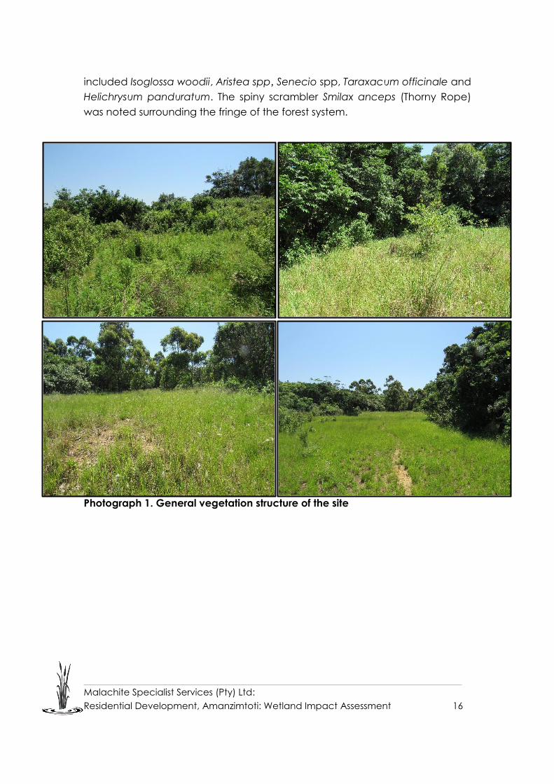
Malachite Specialist Services (Pty) Ltd:
Residential Development, Amanzimtoti: Wetland Impact Assessment 16
included Isoglossa woodii, Aristea spp, Senecio spp, Taraxacum officinale and
Helichrysum panduratum. The spiny scrambler Smilax anceps (Thorny Rope)
was noted surrounding the fringe of the forest system.
Photograph 1. General vegetation structure of the site

Malachite Specialist Services (Pty) Ltd:
Residential Development, Amanzimtoti: Wetland Impact Assessment 17
Photograph 2: Alien invasive species identified within the site including
Ageratum conyzoides and Solanum mauritianum
3.2. Geology and topography
The geology of the proposed study area is associated with the Dwyka Group,
dominated by fill and colluvial soils overlying weathered tillite bedrock. Residual
tillite soils are largely absent (Geosure, 2009). Common soil forms include
Glenrosa, Mispah and Oakleaf soils.
The main topographical unit within the proposed study area consists of
moderately undulating slopes and ridgelines. These topographical units often
give rise to wetlands and watercourse systems. The topography of the
proposed development site becomes increasingly steep on the central portion
of the site in an area associated with the valley bottom. It must also be noted
that various portions of the site, particularly within the south-eastern portion
comprise of cut platforms. Due to these historic construction activities, the soil
characteristics (such as depth and texture) vary significantly in relation to similar
areas on the sites boundary.

Malachite Specialist Services (Pty) Ltd:
Residential Development, Amanzimtoti: Wetland Impact Assessment 18
3.3. Biodiversity
The ecological integrity and connectivity of an area play a vital role in
determining the floral and faunal species composition. The biodiversity of a
particular area is focused on the interaction between living and non-living
organisms. The ability of a habitat to effectively regulate the ecosystem
processes will allow for the provision of important ecosystem services. These
include provision of clean water, climate regulation and carbon sequestration
(Driver et al. 2012). The eThekwini Metropolitan Municipality has a network of
protected areas and a high diversity of habitats. The Durban Metropolitan
Open Space System (D’MOSS) constitutes a network of open areas protected
through conservation zoning, conservation servitudes, land acquisitions and
nature reserve proclamation (eThekwini Municipality Integrated Development
Plan 2012/13 to 2016/17). Despite this, only 10% of D’MOSS is protected and 11%
managed for conservation. Future expansion of D’MOSS areas is required for
the continual preservation of natural habitats and subsequent ecosystems
services within the municipality (eThekwini Municipality Integrated
Development Plan 2012/13 to 2016/17). These areas support a variety of
sensitive faunal and botanical assemblages. Due to the high biodiversity within
the municipality, an efficient biodiversity management system is imperative to
the continue conservation of these sites and the ability of these sites to achieve
conservation targets.
Anthropogenic disturbance due to increased levels of infrastructural
development and the presence of alien invasive species have a negative
impact on biodiversity. Sensitivity of the area was therefore assessed through
the interrogation of biodiversity databases. This indicated that the study site is
situated in an area that is classified as Biodiversity Priority Area 15 (Figure 6). This
is due to the presence of Eastern Scarp Forest, KwaZulu-Natal Coastal Forests,
KwaZulu-Natal Dune Forests, South Coast grassland and the following taxa:
• Doratogonus rubipodus
• Doratogonus montanus
• Begonia rudatisi
• Gerrardanthus tomentosus
• Edouardia conculus
5 Biodiversity Priority Area 1 - Planning units which contain features that, if lost, EKZNW conservation targets cannot be met
in any other planning unit within the Province.

Malachite Specialist Services (Pty) Ltd:
Residential Development, Amanzimtoti: Wetland Impact Assessment 19
• Cochiltoma semidecussata
The area south of the site has been classified as a Biodiversity Priority Area 36
(Figure 6).
As the site falls within a high biodiversity priority area, care must be taken during
the construction phase and best practice methodology must be applied to all
construction activities. This is imperative to ensure that developments do not
impact the sites ability to maintain and achieve the desired conservation
targets. The most significant concerns from a biological functioning
perspective would be the further impact on water resources and probable
further water pollution.
This was confirmed during the site investigation as the large scale dumping of
anthropogenic waste and soil was noted within and surrounding the site. This
increase in waste products coupled with the steep topography of the site,
increases the likelihood of sedimentation of water resources and erosion of
these resources due to increased run off (Figure 5, Photograph 3).
Figure 5: Large scale residential development and patches of indigenous forest
surrounding the study site
6 Planning units which contain features that, if lost, EKZNW conservation targets may be met by alternative site options
available.

Malachite Specialist Services (Pty) Ltd:
Residential Development, Amanzimtoti: Wetland Impact Assessment 20
Photograph 3. Large scale pumping of anthropogenic waste and soil matter
Further impacts to biological functioning within the catchment include faunal
impacts, loss of protected vegetation composition and protected plant
species, encroachment of alien plant species into grassland biomes and lack
of habitat connectivity. The maintenance of landscape connectivity and
ecological corridors are of paramount importance for the persistence of
functioning ecological systems. Present impacts on biodiversity within the study
site include:
i. Portions of natural forests within the larger study area have been altered
and in most cases completely transformed due to anthropogenic
activities.
ii. Vegetation surrounding these transformed areas is dominated by alien
invasive vegetation and weedy pioneer species.
iii. Dumping of sand and building material was noted on the north-western
portion of the site. This has influenced the soil dynamics and facilitated
the encroachment of pioneer alien invasive species
The present impacts on biodiversity within the eThekwini Metropolitan
Municipality include:
i. Habitat loss due to urban sprawl and rural settlements.
ii. A recent survey of alien plant species in managed areas within the
eThekwini Metropolitan identified 130 invasive alien species of which 79
are formally listed under the Conservation of Agricultural Resources Act
No. 43 of 1983 (CARA) (eThekwini Municipality Integrated Development
Plan 2012/13 to 2016/17).
iii. Loss of endemic forbaceous and herbaceous species.

Malachite Specialist Services (Pty) Ltd:
Residential Development, Amanzimtoti: Wetland Impact Assessment 21
iv. Sites of Conservation Value are threatened by rural human settlements.
v. Loss of sensitive sites due to mismanagement/ lack of appropriate
protection.
vi. Aquatic ecosystems are in a poor state. During a bio-monitoring survey
conducted in 2010, 40% of the monitoring sites in the eThekwini Rivers
were considered to be in a poor condition, with only 3% considered near
natural. Impacts pertaining to the degradation of watercourses
included spills, illegal discharge, solid waste dumping, sand mining, flow
reduction through dams, removal of riparian flora and eutrophication.
vii. Poor compliance to environmental legislation lack of political support,
education and awareness campaigns to encourage people to
implement sustainable practices (eThekwini Municipality Integrated
Development Plan 2012/13 to 2016/17).
This combination of factors has resulted in habitat transformation and the
subsequent reduction in suitable habitats for floral and faunal species. As the
central portion of the study site is comprised of a classed D’MOSS area coupled
with the existing levels of habitat transformation and sloping gradient of the
site, it is imperative that mitigation measures are implemented to protect this
conservation site. The implementation of these mitigation measures will
increase the ability of the adjacent coastal forests potential to assist in the
maintenance of biodiversity and conservation targets within the eThekwini
Metropolitan Municipality.

Malachite Specialist Services (Pty) Ltd:
Residential Development, Amanzimtoti: Wetland Impact Assessment 22
Figure 6: Sensitivity map of the study site

Malachite Specialist Services (Pty) Ltd:
Residential Development, Amanzimtoti: Wetland Impact Assessment 23
3.4. Catchment characteristics and watercourses
The proposed development area falls within the quaternary catchment U70F
which is part of the Mgeni Sub Water Management Area (SWA) and the Mvoti
to Umzimkhulu Water Management Area. The major rivers within the Water
Management Area are the uMlazi, Mbokodweni, Lovu and Mkomazi Rivers.
These rivers experience significant levels of high water demand related stress,
particularly during drought seasons. Many of these surrounding communities
rely on fresh water from these rivers throughout the year (DWAF, 2004).
The U70F quaternary catchment is associated with a Moderate ecological
sensitivity status (www.dwa.gov.za/war/systems.html). The Amanzimtoti, Little
Amanzimtoti and Mbokodweni are the main watercourses within the larger
study area and are located approximately 200m south, 3.3km and 3.7km north
of the study site respectively.
Land use within the U70F quaternary catchment is generally associated with
transformation through urban sprawl, road networks, industrial, rural settlements
and livestock grazing. Increasingly large areas of hardened surfaces and a
subsequent lack of stormwater control are primary contributors to soil erosion
within the Mvoti to Umzimkhulu Water Management Area. This area is also
vulnerable to increased levels of water pollution attributed to the urban
expansion and commercial agricultural practices.
The dominant land use surrounding the development site is high density urban
residential and road infrastructure (Figure 7). Historic impacts experienced by
this catchment include the replacement of indigenous and riparian vegetation
with alien invasive species, conversion of coastal forests and the degradation
of wetland systems due to anthropogenic land conversion. The transformation
of biophysical characteristics exacerbates impacts such as erosion,
sedimentation and reduced water quality within the catchment.

Malachite Specialist Services (Pty) Ltd:
Residential Development, Amanzimtoti: Wetland Impact Assessment 24
Figure 7: Land use surrounding the study site including urban residential
development, rural settlements, industrial development and road networks.
3.5. NFEPA
The National Freshwater Ecosystem Priority Areas (NFEPA) is a project that was
developed to provide strategic spatial priorities for conserving South Africa’s
freshwater ecosystems and supporting sustainable use of water resources.
These strategic spatial priorities are known as Freshwater Ecosystem Priority
Areas, or FEPAs (Driver, et al., 2011).
One channelled valley bottom wetland was identified within the NFEPA
database and has been categorised as a FEPA wetland due to its natural
condition (Figure 8). Ground truthing of this wetland however revealed that it is
an alluvial floodplain associated with the Amanzimtoti River system and not a
channelled valley bottom wetland system.

Malachite Specialist Services (Pty) Ltd:
Residential Development, Amanzimtoti: Wetland Impact Assessment 25
Figure 8: Freshwater Ecosystem Priority Area Wetlands identified within the study area

Malachite Specialist Services (Pty) Ltd:
Residential Development, Amanzimtoti: Wetland Impact Assessment 26
4. ASSESSMENT RESULTS
4.1. Soil Wetness and Soil Form Indicator
Soil samples were taken within the development footprint and examined for the
presence of hydric (wetland) characteristics. Hydric soils are defined as those
that typically show characteristics (redoximorphic features) resulting from
prolonged and repeated saturation. Redoximorphic features include the
presence of mottling (i.e. bright insoluble iron compounds); a gleyed matrix;
and/or Mn/Fe concretions (Photograph 4). The presence of redoximorphic
features are the most important indicator of wetland occurrence, as these soil
wetness indicators remain in wetland soils, even if they are degraded or
desiccated (DWAF, 2005). It is important to note that the presence or absence
of redoximorphic features within the upper 500mm of the soil profile alone is
sufficient to identify the soil as being hydric, or non-hydric (Collins, 2005).
Photograph 4: Examples of hydric characteristics used as indicators for wetland
conditions
Soils identified within the site were predominantly shallow as a result of both the
topography of the area, particularly on the north-western portion of the site and
the creation of cut and fill platforms along the south-eastern portion of the site.
The shallow soils were classified as the Mispah soil form in the north-western
portion. However, it must be noted that soil material and refuse has been
dumped onto this soil (Photograph 5). Hydric properties within soil samples taken
along the south-eastern portion of the site were identified. These included a
gleyed matrix as well as mottling. Soil forms could not however be classified in
this area as the soil profile has been significantly altered due to the creation of
the cut and fill platforms. Sediment deposition was identified on the surface of
the soil profile (Photograph 6 and 7).
Mottling
Mn concretion
Gleyed matrix

Malachite Specialist Services (Pty) Ltd:
Residential Development, Amanzimtoti: Wetland Impact Assessment 27
Photograph 5: Mispah soil form with soil and waste dumped on top of it in the north-
western portion of the development footprint.
Photograph 6: Soil profile identified in the south-eastern portion of the site. Note the
sediment deposition on top of the clay layer (A and B) and Mottling (hydric
characteristics) identified within the soil samples taken in the south-eastern portion of
the site (C and D).
A B
C D

Malachite Specialist Services (Pty) Ltd:
Residential Development, Amanzimtoti: Wetland Impact Assessment 28
4.2. Vegetation Indicator
According to DWAF (2005), vegetation is regarded as a key component to be
used in the delineation procedure for wetlands. Vegetation also forms a central
part of the wetland definition in the National Water Act (Act 36 of 1998).
Hydrophytic vegetation are plant species that are adapted to being
permanently or temporarily water logged conditions (elevated water conditions
in wetland soils). These wetland “indicator” species assist in the identification of
wetland systems and associated boundaries.
However, using vegetation as a primary wetland indicator requires undisturbed
conditions (DWAF, 2005); vegetation within the proposed development
footprint has been disturbed as a result of anthropogenic disturbance
(construction and clearing activities) and this disturbance has led to the
encroachment of alien invasive species as well as weedy pioneer species. This
was evident with dense stands of Kyllinga brevifolia noted within the
waterlogged clay soils in the south-eastern portion of the site. K. brevifolia forms
dense stands in seasonally saturated wet areas.
Other species identified within the wetland areas included Imperata cylindrica
(Cotton Wool Grass), Setaria megaphylus, and Helichrysum panduratum.
Historic disturbances surrounding the wetland areas have resulted in the
encroachment of a variety of alien invasive species within the system. These
species included Lantana camara, Ageratum conyzoides, Tagetes minuta,
Bidens pilosa and Nephrolepis exaltata. The encroachment of these species will
continue to alter the functioning of the vegetation assemblages associated with
this ecotone.
4.3. Terrain Indicator
The topography of an area is generally a good practical indicator for identifying
those parts in the landscape where wetlands are likely to occur. Generally,
wetlands occur as a valley bottom unit however wetlands can also occur on
steep to mid slopes where groundwater discharge is taking place through seeps
(DWAF, 2005). In order to classify a wetland system, the localised landscape
setting must be taken into consideration through ground-truthing of the study
site after initial desktop investigations (Ollis et al., 2014).
The proposed development sits on either side of a valley, on the north-western
and south-eastern plateau. The site ranges in altitude from 59m to 75m above
sea level. The topography of the valley becomes progressively steeper toward

Malachite Specialist Services (Pty) Ltd:
Residential Development, Amanzimtoti: Wetland Impact Assessment 29
the valley bottom, where a tributary of the Amanzimtoti River flows in a southerly
direction through the central area of the valley. A second drainage channel,
which flows in a southerly direction is situated to the east of the proposed
development site and the Amanzimtoti River is situated toward the south of the
site and drains in an easterly direction toward the Indian Ocean. The
topographic position of the site however does not indicate wetland areas as it
becomes too steep within the valley to support seepage wetlands (Figure 10).
4.4. Investigation into historical aerial imagery
Despite the occurrence of hydric soils as well as pioneer hydrophytic vegetation
within the south-eastern portion of the proposed development site, the soil form
and topographical position of this area does not correlate with the occurrence
of a wetland system. An investigation into historic aerial imagery as well as
current conditions of this area revealed that the site has been levelled for the
creation of cut and fill platforms. Aerial imagery from 2002 shows the cut and fill
platforms clearly (Figure 9). Further to this, photographic evidence of the current
condition of the site, show the height of the fill embankments in comparison to
the current level of the site (Photograph 7). It is therefore evident that the
removal of soil to form the cut and fill platforms has exposed the underlying clay
layer associated with the original soil profiles within this area. This clay layer has
formed an impermeable barrier to surface water, creating a ponding effect.
The seasonally saturated conditions, which occur after a rainfall event, have
facilitated the change in the chemical composition of the soil matrix giving rise
to the gleyed conditions as well as the formation of some mottling. Pioneer
hydrophytic species have also taken advantage of the seasonally saturated
conditions and have flourished into the south-eastern portion of the
development site (Figure 11).
As per the requirements of DWS, a health, functional integrity and ecological
importance and sensitivity assessment of the wetlands was undertaken to
determine if they contribute to any ecological services within the larger
catchment.

Malachite Specialist Services (Pty) Ltd:
Residential Development, Amanzimtoti: Wetland Impact Assessment 30
Figure 9: Aerial imagery from 2002 showing the cut and fill along the south
eastern portion of the site
Photograph 7: The current height of the fill embankments in relation to the
1.2m soil auger height. This shows the amount of soil removed from this site to
form the cut and fill platform, exposing the underlying clay layer of the original
soil profile

Malachite Specialist Services (Pty) Ltd:
Residential Development, Amanzimtoti: Wetland Impact Assessment 31
Figure 10: All water resources identified within the 500m assessment buffer of the site

Malachite Specialist Services (Pty) Ltd:
Residential Development, Amanzimtoti: Wetland Impact Assessment 32
Figure 11: Series of artificial wetlands identified and delineated within the south-eastern portion of the site

Malachite Specialist Services (Pty) Ltd:
Residential Development, Amanzimtoti: Wetland Impact Assessment 33
4.5. Present Ecological State (PES)
The series of artificial wetlands were assessed in terms of their health and were
categorised as having critical modifications (PES Category F; Table 7). This score
indicates that the artificial wetlands do not have functioning ecosystem
processes as there is no natural habitat and biota.
Table 7: Summary of PES score
HYDROLOGY GEOMORPHOLOGY VEGETATION PES SCORE
(CATEGORY)
9.5 9.9 9.1 F
(9,50)
4.6. Functional Assessment (Ecosystem Goods and Services)
Ecosystem goods and services were calculated for the artificial wetland. The
scores obtained for this assessment were very low to low as a result of the lack
of functional integrity associated with these artificial wetlands (Table 8 and
Figure 12).
Table 8: Summary of scores received from the Functional Assessment
ECOSYSTEM GOODS AND
SERVICES
ARTIFICIAL
WETLAND
CATEGORY
Flood attenuation 1.1 Low
Streamflow regulation 1.2 Low
Sediment trapping 1.0 Low
Phosphate trapping 1.0 Low
Nitrate removal 1.2 Low
Toxicant removal 1.0 Low
Erosion control 1.0 Low
Carbon storage 1.0 Low
Maintenance of
biodiversity 0.3 Very Low
Water supply for human
use 0.9 Very Low

Malachite Specialist Services (Pty) Ltd:
Residential Development, Amanzimtoti: Wetland Impact Assessment 34
Natural resources 0.0 Very Low
Cultivated foods 0.0 Very Low
Cultural significance 0.0 Very Low
Tourism and recreation 0.1 Very Low
Education and research 0.0 Very Low
Figure 12: General WET-EcoServices results for the Seep
4.7. Ecological Importance and Sensitivity (EIS)
The Ecological Importance and Sensitivity of the wetland has been recorded as
being very low (Table 9), as a result of the lack of functional integrity and health
associated with these wetlands. The wetlands do not provide any ecological
support within the larger landscape, including the use of the wetlands as a
habitat for feeding or protection.

Malachite Specialist Services (Pty) Ltd:
Residential Development, Amanzimtoti: Wetland Impact Assessment 35
Table 9: Summary of the Ecological Importance and Sensitivity
HGM UNIT EIS SCORE
CONFIDENCE
CATEGORY
Seep
Ecological
Importance and
Sensitivity
0.07 2.78 Very Low
Hydrological
Functional
Importance
2.07 2.50 Very Low
Direct Human Benefits 0 3.00 None
5. RECOMMENDATIONS FOR DEVELOPMENT
Based on the findings of this assessment, the seasonally inundated artificial
wetlands provide no ecosystem goods and services to the larger catchment.
Further to this, these areas do not provide sufficient ecological opportunities for
indigenous floral and faunal species and can be considered to have a very low
ecological importance. The removal of the artificial wetlands for the proposed
development will not result in a net loss of wetlands within this catchment and it
is recommended that the development proceed.
Despite this, the proposed development will result in an increase in hardened
surfaces. Given that the development footprint is situated adjacent to steep
topography and a D’MOSS area, the proposed housing development is likely to
have a negative impact on the downstream water resources. This is particularly
so as the cumulative impact of continued development has changed the
dynamics of the catchment. It is therefore imperative that the mitigation
measures outlined below are implemented and best practice methods are
adhered to during construction and operational phases.

Malachite Specialist Services (Pty) Ltd:
Residential Development, Amanzimtoti: Wetland Impact Assessment 36
6. IMPACT DESCRIPTION, ASSESSMENT & MITIGATION
Any development activity in a natural system will have an impact on the
surrounding environment, usually in a negative way. The purpose of this phase
of the study was to identify and assess the significance of the impacts caused
by the proposed construction of the residential development on the
downstream watercourse within the valley bottom and to provide a description
of the mitigation required so as to limit the identified negative impacts on the
receiving environment.
The impact assessment identified the following negative impacts associated
with the proposed development; (i) soil erosion and sedimentation of the
watercourse system; (ii) pollution as a result of runoff from the construction area
entering into the watercourse, and (iii) disturbance thereby increasing the
encroachment of alien invasive species. Several general and specific measures
are proposed to mitigate these impacts on the wetland system.
6.1 Soil Erosion, sedimentation and degradation within the downslope
watercourse
Impacts associated with soil erosion and sedimentation
Future Impact
Probability Duration Extent Magnitude Significance
scoring
without
mitigation
Significance
scoring with
mitigation With
out With
With
out With
With
out With
With
out With
Construction Phase
Soil erosion
and
sedimentation
5 4 2 2 2 1 8 4 60
(high)
28
(low)
Operational Phase
Degradation
of
watercourse
3 2 5 5 2 1 8 6 45
(moderate)
24
(low)
Description of impact
Construction activities (i.e. excavations and vegetation clearing) expose soil to
environmental factors including rainfall and wind. The exposure to these factors
will result in the removal of topsoil and the deposition of this sediment in the
downslope watercourse system. This increased high-suspended particulate
matter within the watercourse can accumulate particularly during the summer

Malachite Specialist Services (Pty) Ltd:
Residential Development, Amanzimtoti: Wetland Impact Assessment 37
months leading to the sedimentation of this system. This poses a risk to the
geomorphological/functional integrity of the water resource system, reducing
its ecological integrity.
The risk and potential impact of soil erosion will be highest during the
construction (removal of vegetation and creation of excavations) phase. The
risk of this impact will be significantly lower during the operational phase,
particularly if disturbed areas are rehabilitated and vegetated.
Mitigation Options
• Attenuation of stormwater from the development site is important to reduce
the velocity of runoff into the downstream wetland area.
• Attenuation measures during construction include but are not limited to - the
use of sand bags, hessian sheets, silt fences, retention or replacement of
vegetation and geotextiles such as soil cells which must be used in the
protection of slopes.
• Long term attenuation measures are recommended in the design of the
development and can include permeable paving; infiltration trenches or
swales. Examples are shown below:
Example of permeable paving
• Indigenous landscaping in open areas needs to be incorporated in the
management plan.

Malachite Specialist Services (Pty) Ltd:
Residential Development, Amanzimtoti: Wetland Impact Assessment 38
• Do not allow surface water or storm water to be concentrated, or to flow
down cut or fill slopes without erosion protection measures being in place.
• Vegetation clearing must be undertaken only in the areas to be developed
and must not extend outside of the development footprint.
• The implementation of soft engineering7 measures, Sustainable Drainage
Systems (SuDs) and Level Spreaders are recommended to mitigate the
impacts associated with increased stormwater runoff.
o Level Spreaders are measures that reduce the erosive energy of
concentrated flows by distributing runoff as sheet flow to stabilised
vegetative surfaces. Further to this, they also promote the infiltration of
surface water thereby causing filtering and improving water quality
(Figure 13).
o It is also recommended that grassed swales be used with a few
depressions into which the stormwater can be discharged.
Figure 13: Example of a level spreader to be used for erosion control.
7 Ecologically based stormwater management principles integrated with soft
engineering design, by using natural features in combination with artificial materials.

Malachite Specialist Services (Pty) Ltd:
Residential Development, Amanzimtoti: Wetland Impact Assessment 39
Further to this mitigation measures which utilise Sustainable Drainage Systems as
well as the integration of green design elements can be implemented in the
design of the development. The principals behind the use of SuDs see the
traditional thinking behind drainage systems changing to the need to
encourage flood waters to infiltrate to groundwater as quickly as possible in the
immediate area rather than channelling it away. Consideration is given to water
quality as well as the amenity and biodiversity values of water, thereby
improving the hydrological
These include:
• waste recycling,
• green infrastructure,
• solar energy, and
• the implementation of indigenous landscaping.
These methods will assist in the control of surface runoff reducing erosion
potential and the maintenance of the biodiversity potential of the study area.
6.2 Pollution of water resources and soil
Impacts associated with the construction phase of the activities
Potential
impact
Probability Duration Extent Magnitude Significanc
e scoring
without
mitigation
Significanc
e scoring
with
mitigation
With
out With
With
out With
With
out With
With
out With
Construction Phase
Pollution of
water
resources
and soil
4 3 2 2 2 1 8 6 48
moderate)
27
(low)
Operational Phase
Pollution of
water
resources
and soil
3 2 5 5 2 1 6 4 39
(moderate)
20
(low)
Description of the impact
from a Sediment release construction site into the downstream aquatic
environment is one of the most common forms of waterborne pollution.
Furthermore, mismanagement of waste and pollutants including hydrocarbons,
construction waste and other hazardous chemicals will result in these
substances entering and polluting the sensitive natural downstream

Malachite Specialist Services (Pty) Ltd:
Residential Development, Amanzimtoti: Wetland Impact Assessment 40
environments either directly through surface runoff during rainfall events, or
subsurface water movement.
An increase in pollutants will lead to changes in the water quality of the
watercourse, affecting its ability to act as an ecological corridor in the larger
landscape.
Mitigation Options
• All waste generated during construction is to be disposed of as per an
Environmental Management Programme (EMPr) and washing of containers,
wheelbarrows, spades, picks or any other equipment that has been
contaminated with cement or chemicals in the identified watercourses must
be strictly prohibited.
• Proper management and disposal of construction waste must occur during
the construction of the development.
• Waste disposal during the operational phase must ensure no litter or other
contaminants on site are deposited in the downstream water resource
environment.
• No release of any substance i.e. cement or oil, that could be toxic to fauna
or faunal habitats within the watercourse.
• Spillages of fuels, oils and other potentially harmful chemicals must be
cleaned up immediately and contaminants properly drained and disposed
of using proper solid/hazardous waste facilities (not to be disposed of within
the natural environment). Any contaminated soil must be removed, and the
affected area rehabilitated immediately.

Malachite Specialist Services (Pty) Ltd:
Residential Development, Amanzimtoti: Wetland Impact Assessment 41
6.3 Proliferation of alien invasive species
Impacts associated with the proliferation of alien invasive species
Impact
Probability Duration Extent Magnitude Significance
scoring
without
mitigation
Significance
scoring with
mitigation With
out With
With
out With
With
out With
With
out With
Construction Phase
Spread of
alien
invasive
species
3 2 2 2 2 1 6 4 30
(moderate)
14
(low)
Operational Phase
Spread of
alien
invasive
species
4 3 5 5 2 1 6 4 52
(moderate)
30
(low-
moderate)
Description of the impact
Any disturbance of the area will have a further negative impact on the
vegetation community of the site making the larger area and adjacent D’MOSS
site more susceptible to encroachment by invasive alien species.
A significant number of alien invasive species were identified on site, these
species will continue to encroach into disturbed areas if no maintenance is
carried out. Alien species generally out-compete indigenous species for water,
light, space and nutrients as they are adaptable to changing conditions and
are able to easily invade a wide range of ecological niches (Bromilow, 2010).
Alien invader plant species pose an ecological threat as they alter habitat
structure, lower biodiversity (both number and “quality” of species), change
nutrient cycling and productivity, and modify food webs (Zedler, 2004).
Mitigation Options
• Ongoing alien plant control must be undertaken after the construction
phase and during the operational phase. An ongoing management plan
must be implemented for the clearing/eradication of alien species.
• It is recommended that indigenous species are planted in the
garden/landscaped areas to control the spread of alien species outside of
the development area.

Malachite Specialist Services (Pty) Ltd:
Residential Development, Amanzimtoti: Wetland Impact Assessment 42
7. RISK ASSESSMENT
The Risk Assessment for the proposed project as per the General Authorisation
in terms of Section 39 of the National Water Act, 1998 (Act No. 36 of 1998) for
Water Uses as defined in Section 21 (c) and (i) (Notice 509 of 2016) was
undertaken.
The risk assessment involves the analysis of the risk matrix provided in Appendix
1 of this Notice and involves the evaluation of the severity of impacts to the flow
regime, water quality, habitat, and biota of the water resource. Based on the
outcome of the Risk Assessment Matrix, Low risk activities will be generally
authorised with conditions, while Moderate to High risk activities will be required
to go through a Water Use Licence Application Process. Water use activities that
are authorised in terms of the General authorisations will still need to be
registered with the DWS.
It should be borne in mind that when assessing the impact significance following
the DWS Risk Assessment Matrix, determination of the significance of the impact
assumes that mitigation measures as listed within the present report are feasible
and will be implemented, and as such does not take into consideration
significance before implementation of mitigation measures. Accordingly,
should proposed mitigation measures not be deemed feasible, a re-evaluation
of the impact significance may be required.
The risk assessment is provided in Appendix B. As the artificial wetland
delineated within the site provide no ecological goods and services to the
catchment and do not support any habitat for floral or faunal species all
potential impacts on these water resources receive Low Risk Scores.
Furthermore, due to the distance of the watercourse within the valley bottom to
the construction site all potential risks to the resource quality of the water course
received Low Risk scores. The proposed development will therefore not result in
the net loss of functional wetlands within the catchment and is recommended
to proceed.

Malachite Specialist Services (Pty) Ltd:
Residential Development, Amanzimtoti: Wetland Impact Assessment 43
8. CONCLUSION
The proposed development footprint is situated on two opposite sides of a steep
valley. A watercourse is situated at the base of this valley and is a tributary of
the Amanzimtoti River. A field investigation of the site revealed that cut and fill
platforms have been created along the south-eastern portion of the proposed
development area. This cut and fill activity has removed a large quantity of soil
within the site and exposed an underlying clay layer of the original soil profile.
This clay layer has formed an impermeable barrier to surface water, creating a
ponding effect. The seasonally saturated conditions which occur after a rainfall
event have allowed for the change in the chemical composition of the soil
matrix giving rise to the gleyed conditions as well as the formation of some
mottling. Pioneer hydrophytic species have also taken advantage of the
seasonally saturated conditions and have encroach into the south-eastern
portion of the development site.
As per the requirements of DWS, a health, functional integrity and ecological
importance and sensitivity assessment of the wetlands was undertaken to
determine if they contribute to any ecological services within the larger
catchment. The current status of the wetland system was assessed using the
wetland health methodology and the wetlands were categorised as having
critical modifications (PES Category F). This score indicates that the artificial
wetlands do not have functioning ecosystem processes as there is no natural
habitat and biota. Ecosystem goods and services were calculated for the
artificial wetland. The scores obtained for this assessment were very low to low
as a result of the lack of functional integrity associated with these artificial
wetlands.
An Ecological Importance and Sensitivity (EIS) assessment was undertaken to
rank the water resource in terms of provision of goods and service or valuable
ecosystem functions which benefit people; biodiversity support and ecological
value; and reliance of subsistence users (especially basic human needs uses).
The Ecological Importance and Sensitivity of the wetland has been recorded as
being very low as a result of the lack of functional integrity and health
associated with these wetlands. The wetlands do not provide any ecological
support within the larger landscape, including the use of the wetlands as a
habitat, for feeding or protection.

Malachite Specialist Services (Pty) Ltd:
Residential Development, Amanzimtoti: Wetland Impact Assessment 44
Based on the findings of this assessment, the seasonally inundated artificial
wetlands provide no ecosystem goods and services to the larger catchment.
Further to this, these areas do not provide sufficient ecological opportunities for
indigenous floral and faunal species and can be considered to have a very low
ecological importance. The removal of the artificial wetlands for the proposed
development will not result in a net loss of wetlands within this catchment and it
is recommended that the development proceed.
Despite this, the proposed development will result in an increase in hardened
surfaces. Given that the development footprint is situated adjacent to steep
topography and a D’MOSS area, the proposed housing development is likely to
have a negative impact on the downstream water resources. This is particularly
so as the cumulative impact of continued development has changed the
dynamics of the catchment.
An impact assessment was therefore conducted to assess the significance of
the impacts caused by the proposed construction of the residential
development on the downstream watercourse within the valley bottom. The
following negative impacts were identified; (i) soil erosion and sedimentation;
(ii) pollution as a result of runoff from the development area entering into the
watercourse, and (iii) disturbance within the area thereby increasing the
encroachment of alien invasive species.
Several general and specific measures are proposed to mitigate these impacts
on the receiving environment. Stormwater management recommendations
have been considered as the continued conversion of the catchment to
impermeable surfaces will generate increased runoff and this has implications
on water resources situated below the development footprint.
Based on the findings of this assessment, the seasonally inundated artificial
wetlands provide no ecosystem goods and services to the larger catchment.
Further to this, these areas do not provide sufficient ecological opportunities for
indigenous floral and faunal species and can be considered to have a very low
ecological importance. The removal of the artificial wetlands for the proposed
development will not result in a net loss of wetlands within this catchment and it
is recommended that the development proceed provided stormwater
management is undertaken as per the Environmental Management
Programme.

Malachite Specialist Services (Pty) Ltd:
Residential Development, Amanzimtoti: Wetland Impact Assessment 45
The Risk Assessment for the proposed project as per the General Authorisation
in terms of Section 39 of the National Water Act, 1998 (Act No. 36 of 1998) for
Water Uses as defined in Section 21 (c) and (i) (Notice 509 of 2016) was
undertaken. As the artificial wetland delineated within the site provide no
ecological goods and services to the catchment and do not support any
habitat for floral or faunal species all potential impacts on these water resources
receive Low Risk Scores. Furthermore, due to the distance of the watercourse
within the valley bottom to the construction site all potential risks to the resource
quality of the water course received Low Risk scores. The proposed
development will therefore not result in the net loss of functional wetlands within
the catchment and is recommended to proceed.

Malachite Specialist Services (Pty) Ltd:
Residential Development, Amanzimtoti: Wetland Impact Assessment 46
9. REFERENCES
Boon R. 2010. Pooley’s Trees of Eastern South Africa: A complete guide. Flora and Fauna
Publications Trust, Durban
Collins, N.B. (2005). Wetlands: The basics and some more. Free State Department of
Tourism, Environment and Economic Affairs.
Driver, A., Nel, J., Snaddon, K., Murray, K., Roux, D., Hill, L., & Swartz, E. (2011).
Implementation Manual for Freshwater Ecosystem Priority Areas. WRC Report No.
1801/1/11. Pretoria: Water Research Commission.
DWAF, D. O. (2005). A Practical Field Procudure for Identification and Delineation of
Wetlands and Riparian Areas - Edition 1.
Kotze, D., et al, Marneweck, G., Batchelor, A., Lindley, D., & Collins, N. (2007). WET-
EcoServices: A technique for rapidly assessing ecosystem services supplied by
wetlands. WRC Report No TT 339/08. Pretoria: Water Research Commission.
Fey, M. (2010). Soils of South Africa. Their distribution, properties, classification, genesis,
use and environmental significance. Cambridge University Press. Cape Town
Geosure (2009). Report to Sure Focus Twenty Two cc on the Results of a Geotechnical
Investigation for the Proposed Residential Development Comprising Portion 1 of
25, 1 of 27 and the Remainder of 27 in Amanzimtoti, KwaZulu-Natal
Macfarlane, D., Kotze, D., Ellery, W., Walters, D., Koopman, V., Goodman, P., & Goge,
C. (2007). WET-Health: A Technique for rapidly assessing wetland health. WRC
Report No TT 340/08. Pretoria: Water Reseach Commision.
Macfarlane, D.M., Bredin, I.P., Adams, J.B., Zungu, M.M., Bate, G.C. and Dickens, C.W.S.
2015. Preliminary guideline for the determination of buffer zones for rivers,
wetlands and estuaries. Final Consolidated Report. WRC Report No TT 610/14,
Water Research Commission, Pretoria.
Mucina, L., Rutherford, M.C. & Powrie, L.W. (eds). (2006). Vegetation Map of South
Africa, Lesotho and Swaziland, edn 2, 1:1 000 000 scale sheet maps. South
African National Biodiversity Institute, Pretoria. ISBN 978-1-919976-42-6.

Malachite Specialist Services (Pty) Ltd:
Residential Development, Amanzimtoti: Wetland Impact Assessment 47
Ollis, D., Snaddon, K., Job, N., & Mbona, N. (2013). Classification Systems for Wetlands
and other Aquatic Ecosystems in South Africa. User Manual: Inland Systems.
SANBI Biodiversity Series 22. Pretoria: South African National Biodiversity Institute.
Pooley E. 1998. A field guide to the wild flowers of KwaZulu-Natal and the Eastern Region.
Natal Flora Publications Trust, Durban.
Scott-Shaw, R., & Escott, B. (2012). KwaZulu-Natal Provincial Pre-transformation
Vegetation Type. Pietermaritzburg: Ezemvelo KZN Wildlife.
Soil Classification Working Group, (1991). Soil Classification: A Taxonomic System for
South Africa. Department of Agriculture
Van Oudtshoorn F. 1992. Guide to grasses of South Africa. Briza Publications, Arcadia.
Van Wyk B & van Wyk P. 2007. Field guide to trees of South Africa. Struik Publishers. Cape
Town.
Water Resource Commission. 2011. Easy Identification of some South African Wetland
Plants. WRC Report No TT 479/10.

Malachite Specialist Services (Pty) Ltd:
Residential Development, Amanzimtoti: Wetland Impact Assessment 48
10. APPENDICES
APPENDIX A – WETLAND AND RIPARIAN ASSESSMENT METHODOLOGY
Wetland Delineation Technique
For the purpose of this assessment, wetlands are considered as those
ecosystems defined by the National Water Act as:
“land which is transitional between terrestrial and aquatic
systems where the water table is usually at or near the surface,
or the land is periodically covered with shallow water, and
which land in normal circumstances supports or would support
vegetation typically adapted to life in saturated soil.”
The study site was assessed with regards to the determination of the presence
of wetland areas according to the procedure described in ‘A Practical Field
Procedure for Identification and Delineation of Wetland and Riparian Areas –
Edition 1’(DWAF, 2005). This methodology requires the delineator to give
consideration to the following four indicators in order to identify wetland areas;
to find the outer edge of the wetland zone; and identify the different zones of
saturation within the wetland systems identified:
i. Terrain Unit Indicator: helps to identify those parts of the landscape where
wetlands are more likely to occur.
ii. Soil Form Indicator: identifies the soil forms, as defined by the Soil
Classification Working Group (1991), which are associated with
prolonged and frequent saturation.
iii. Soil Wetness Indicator: identifies the morphological "signatures"
developed in the soil profile as a result of prolonged and frequent
saturation. Signs of wetness are characterised by a variety of aspects
including marked variations in the colour of various soil components,
known as mottling; a gleyed soil matrix; or the presence of Fe/Mn
concretions. It should be noted that the presence of signs of wetness
within a soil profile is sufficient to classify an area as a wetland area
despite the lack of other indicators.
iv. Vegetation Indicator: identifies hydrophilic vegetation associated with
frequently saturated soils.
In assessing whether an area is a wetland, the boundary of a wetland should be
considered as the point where the above indicators are no longer present. An

Malachite Specialist Services (Pty) Ltd:
Residential Development, Amanzimtoti: Wetland Impact Assessment 49
understanding of the hydrological processes active within the area is also
considered important when undertaking a wetland assessment. Indicators
should be 'combined' to determine whether an area is a wetland, to delineate
the boundary of that wetland and to assess its level of functionality and health.
Assessment of the Wetland’s Functional Integrity
Wetlands within the study area serve to improve habitat within and potentially
downstream of the study area through the provision of various ecosystem
services. These ecosystem services relate to:
• Flood attenuation;
• Streamflow regulation;
• Water purification (including sediment trapping and the assimilation of
phosphates, nitrates and toxicants);
• Carbon storage;
• Maintenance of biodiversity;
• Provision of water for human and agricultural use;
• Cultural benefits (including tourism, recreation and cultural heritage).
Wetlands therefore affect the quantity and quality of water within a catchment
(Mitsch and Gosselink, 1993). The importance of wetland conservation and
sustainable management is directly related to the value of the functions
provided by a wetland (Smathkin and Batchelor, 2005); An indication of the
functions and ecosystem services provided by wetlands is assessed through the
WET-EcoServices manual (Kotze et al., 2008) and is based on a number of
characteristics that are relevant to the particular benefit provided by the
wetland. The tool uses biophysical characteristics of the wetland and the level
of disturbance within the wetland and its catchment to estimate the level of
supply of ecosystem goods and services. A Level 2 WET-EcoServices assessment
was undertaken for the wetlands identified. A Level 2 assessment is the highest
WET-EcoServices assessment that can be undertaken and involves an on-site
assessment as well as desktop work.
Assessment of the Wetland’s Present Ecological State (PES)
The Present Ecological State (PES) for wetlands which is defined as ‘a measure
of the extent to which human impacts have caused the wetland to differ from
the natural reference condition’ is also an indication of each wetland’s ability
to contribute to ecosystem services within the study area. This was assessed
according to the methods contained in the Level 2 WET-Health: A technique for
rapidly assessing wetland health (Macfarlane, et al., 2009)

Malachite Specialist Services (Pty) Ltd:
Residential Development, Amanzimtoti: Wetland Impact Assessment 50
This document assesses the health status of a wetland through evaluation of
three main factors -
❖ Hydrology: defined as the distribution and movement of water through a
wetland and its soils.
❖ Geomorphology: defined as the distribution and retention patterns of
sediment within the wetland.
❖ Vegetation: defined as the vegetation structural and compositional
state.
The WET-Health tool evaluates the extent to which anthropogenic changes
have impacted upon the functional integrity or health of a wetland through
assessment of the above-mentioned three factors. The deviation from the
natural condition is given a rating based on a score of 0-10 with 0 indicating no
impact and 10 indicating modifications have reached a critical level. Since
hydrology, geomorphology and vegetation are interlinked their scores are then
aggregated to obtain an overall PES health score These scores are then used to
place the wetland into one of six health classes (A – F; with A representing
completely unmodified/natural and F representing severe/complete deviation
from natural as depicted in Table 10.
Table 10: Health categories used by WET-Health for describing the integrity of
wetlands
DESCRIPTION IMPACT
SCORE
HEALTH
CATEGORY
Unmodified, natural. 0 - 1.0 A
Largely natural with few modifications. A slight change in
ecosystem processes is discernible and a small loss of natural
habitats and biota may have taken place.
1.1 - 2.0 B
Moderately modified. A moderate change in ecosystem
processes and loss of natural habitats has taken place but the
natural habitat remains predominantly intact
2.1 - 4.0 C
Largely modified. A large change in ecosystem processes and
loss of natural habitat and biota and has occurred. 4.1 - 6.0 D
The change in ecosystem processes and loss of natural habitat
and biota is great but some remaining natural habitat features
are still recognizable.
6.1 - 8.0 E
Modifications have reached a critical level and the ecosystem
processes have been modified completely with an almost
complete loss of natural habitat and biota.
8.1 - 10.0 F

Malachite Specialist Services (Pty) Ltd:
Residential Development, Amanzimtoti: Wetland Impact Assessment 51
Due to differences in the pattern of water flow through various hydro-
geomorphic (HGM) types, the tool requires that the wetland is divided into
distinct HGM units at the outset. Ecosystem services for each HGM unit are then
assessed separately.
Assessment of Ecological Importance and Sensitivity (EIS)
The Ecological Importance and Sensitivity (EIS) assessment was determined by
utilising a rapid scoring system. The system has been developed to assess the
‘Ecological Importance and Sensitivity’ of the wetland within the larger
landscape; the ‘Hydrological Functional Importance’ of the wetland; and the
‘Direct Human Benefits’ obtained from the wetland through either subsistence
or cultural practices. The scoring assessments for these three aspects of wetland
importance and sensitivity have been based on the requirements of the NWA,
the original Ecological Importance and Sensitivity assessments developed for
riverine assessments (DWAF, 1999), and the work conducted by Kotze et al
(2008) on the assessment of wetland ecological goods and services from the
WET-EcoServices tool. The scores obtained were placed into a category of very
low; low; medium; high; and very high as shown:
• Very low: 0 – 1.0
• Low: 1.1 – 2.0
• Medium: 2.1 – 3.0
• High: 3.1 – 4.0
• Very High 4.1 – 5.0

Malachite Specialist Services (Pty) Ltd:
Residential Development, Amanzimtoti: Wetland Impact Assessment 52
APPENDIX B – RISK MATRIX
RISK MATRIX (Based on DWS 2015 publication: Section 21 c and I water use Risk Assessment Protocol)
NAME and REGISTRATION No of SACNASP Professional member: Rowena Harrison Reg no. 400715/15
Risk to be scored for construction and operational phases of the project. MUST BE COMPLETED BY SACNASP PROFESSIONAL MEMBER REGISTERED IN AN APPROPRIATE FIELD OF EXPERTISE.
Se
ve
rity
Se
ve
rity
Sp
atia
l sc
ale
Du
ratio
n
Co
nse
qu
en
ce
Fre
qu
en
cy
of
ac
tivity
Fre
qu
en
cy
of
imp
ac
t
Leg
al Is
sue
s
De
tec
tio
n
Lik
elih
oo
d
Sig
nific
an
ce
Ris
k R
atin
g
Co
nfid
en
ce
le
ve
l
Co
ntr
ol M
ea
sure
s
Bo
rde
rlin
e L
OW
MO
DER
ATE
Ra
tin
g C
lass
es
PES A
ND
EIS
OF
WA
TER
CO
UR
SE
N
o. Phases Activity Aspect Impact
Flo
w
Re
gim
e
Ph
ysi
co
&
Ch
em
ica
l
(Wa
ter
Qu
ality
)
Ha
bita
t
(Ge
om
orp
h
+
Ve
ge
tatio
n
Bio
ta
1 Construction
Phase Loss of wetland areas
Removal of
hydric soils
identified on site
during the
construction of
the
development
1 1 1 1 1 1 1 3 4 1 5 1 11 33 L 80
As per
Section
6 of the
Wetlan
d
Impact
Assess
ment
report
3
artifici
al
wetlan
ds, PES
F and
EIS
very
low.
These
are
non-
functi
onal
artifici
al
wetlan
ds
2 Construction
Phase
Soil erosion and sediment
deposition within the valley
bottom watercourse
Disturbance to
vegetation,
compaction of
soil, erosion,
sediment
deposition
downslope of
the construction
site
2 2 1 1 1.5 1 1 3.5 4 1 5 1 11 38.5 L 80
As per
Section
5 of the
Wetlan
d
Impact
Assess
ment
report
3
artifici
al
wetlan
ds, PES
F and
EIS
very
low.
These
are
non-

Malachite Specialist Services (Pty) Ltd:
Residential Development, Amanzimtoti: Wetland Impact Assessment 53
functi
onal
artifici
al
wetlan
ds
3 Construction
Phase
Pollution of watercourse
and soil
Sediment
release
construction site
into the
downstream
aquatic
environment.
Mismanagement
of waste and
pollutants
including
hydrocarbons,
construction
waste and other
hazardous
chemicals
1 2 1 1 1.25 1 1 3.25 4 1 5 1 11 35.75 L 80
As per
Section
6 of the
Wetlan
d
Impact
Assess
ment
report
3
artifici
al
wetlan
ds, PES
F and
EIS
very
low.
These
are
non-
functi
onal
artifici
al
wetlan
ds
4 Construction
Phase
Proliferation of alien
invasive species
Disturbance
leading to the
colonisation of
alien invasive
species
1 1 1 1 1 1 1 3 4 1 5 1 11 33 L 80
As per
Section
6 of the
Wetlan
d
Impact
Assess
ment
report
3
artifici
al
wetlan
ds, PES
F and
EIS
very
low.
These
are
non-
functi
onal
artifici
al
wetlan
ds
5 Operational
Phase
Soil erosion and
sedimentation of
watercourse in valley
bottom
Hardened
surfaces from the
development
leading to an
increase in your
1 1 1 1 1 1 1 3 1 1 5 1 8 24
L
70
As per
Section
6 of the
Wetlan
d
Impact
3
artifici
al
wetlan
ds, PES
F and

Malachite Specialist Services (Pty) Ltd:
Residential Development, Amanzimtoti: Wetland Impact Assessment 54
Assess
ment
report
EIS
very
low.
These
are
non-
functi
onal
artifici
al
wetlan
ds
6 Operational
Phase
Pollution of soil and
downstream watercourse
Pollution of soil
and downstream
watercourse
from hardened
surfaces and
urban
environment
1 1 1 1 1 1 1 3 1 1 5 1 8 24 L 70
As per
Section
6 of the
Wetlan
d
Impact
Assess
ment
report
3
artifici
al
wetlan
ds, PES
F and
EIS
very
low.
These
are
non-
functi
onal
artifici
al
wetlan
ds
7 Operational
Phase
Encroachment of alien
invasive species
Disturbance
leading to the
colonisation of
alien invasive
species
1 1 2 1 1.25 2 1 4.25 1 1 5 1 8 34 L 70
As per
Section
6 of the
Wetlan
d
Impact
Assess
ment
report
3
artifici
al
wetlan
ds, PES
F and
EIS
very
low.
These
are
non-
functi
onal
artifici
al
wetlan
ds