Western Sydney Infrastructure Plan – 1 July 2016 – … · 2 Western Sydney Infrastructure Plan...
36
Western Sydney Infrastructure Plan 1 July 2016 – 30 June 2017 Report Card
Transcript of Western Sydney Infrastructure Plan – 1 July 2016 – … · 2 Western Sydney Infrastructure Plan...
Western Sydney Infrastructure Plan 1 July 2016 – 30 June 2017 Report Card
Western Sydney Infrastructure Plan | 1 July 2016 – 30 June 2017 Report Card
Contents
Front cover: The Bringelly Road upgrade at intersection of Camden Valley Way, Bringelly Road and Cowpasture Road, Leppington
Western Sydney Infrastructure Plan overview 3
Progress 4Employment 5
Supporting Local Business 5
Providing Employment Opportunities 5
Expenditure 6
Milestones 7
Environment 8
Work, Health and Safety 9
Consultation 10
Werrington Arterial Road 11
Bringelly Road upgrade 13Bringelly Road upgrade – Stage 1 14
Bringelly Road upgrade – Stage 2 16
The Northern Road upgrade 18The Northern Road upgrade, The Old Northern Road to Peter Brock Drive 19
The Northern Road upgrade, Peter Brock Drive to Mersey Road 21
The Northern Road upgrade, Mersey Road to Glenmore Parkway 23
The Northern Road upgrade, Glenmore Parkway to Jamison Road 25
M12 Motorway 27
Glenbrook Intersection upgrade 29
Local Roads Package 30
1
The flagship Western Sydney Infrastructure Plan (WSIP) has achieved major milestones over the last 12 months.
A significant achievement was the opening to traffic of the new Werrington Arterial Road between the Great Western Highway and M4 Motorway. The new east facing ramps are helping to ease congestion on other M4 Motorway ramps, particularly those at The Northern Road and Mamre Road.
With the opening of the Werrington Arterial Road, as of 30 June 2017, two kilometres of WSIP road construction are complete and 29.6 kilometres are under construction. This includes work on two more sections of The Northern Road, between Peter Brock Drive, Oran Park and Mersey Road, Bringelly and between Glenmore Parkway, Glenmore Park and Jamison Road, South Penrith. The second stage of the Bringelly Road upgrade between King Street, Rossmore and The Northern Road, Bringelly is also now under contract.
This $3.6 billion plan will ensure that road connections are ready before the airport opens and will support future housing development and economic precincts.
In November 2016, we selected the preferred corridor route for the M12 Motorway which will form the new east‑west connection between the M7 Motorway, Cecil Hills and The Northern Road, Luddenham and provide direct access to the new Western Sydney Airport. The preliminary road design is now being developed and work on this new motorway is expected to start in the early 2020s.
Western Sydney businesses are already experiencing benefits from WSIP projects and as of 30 June 2017, around $108 million worth of contracts had been awarded to businesses based in western Sydney from the projects that were in construction during the year.
We have also made significant progress with job creation in western Sydney. As of 30 June 2017, around 910 full time equivalent jobs have been created as part of WSIP projects. This is almost a quarter of the forecast 4000 direct and indirect jobs expected to be created over the 10 year program.
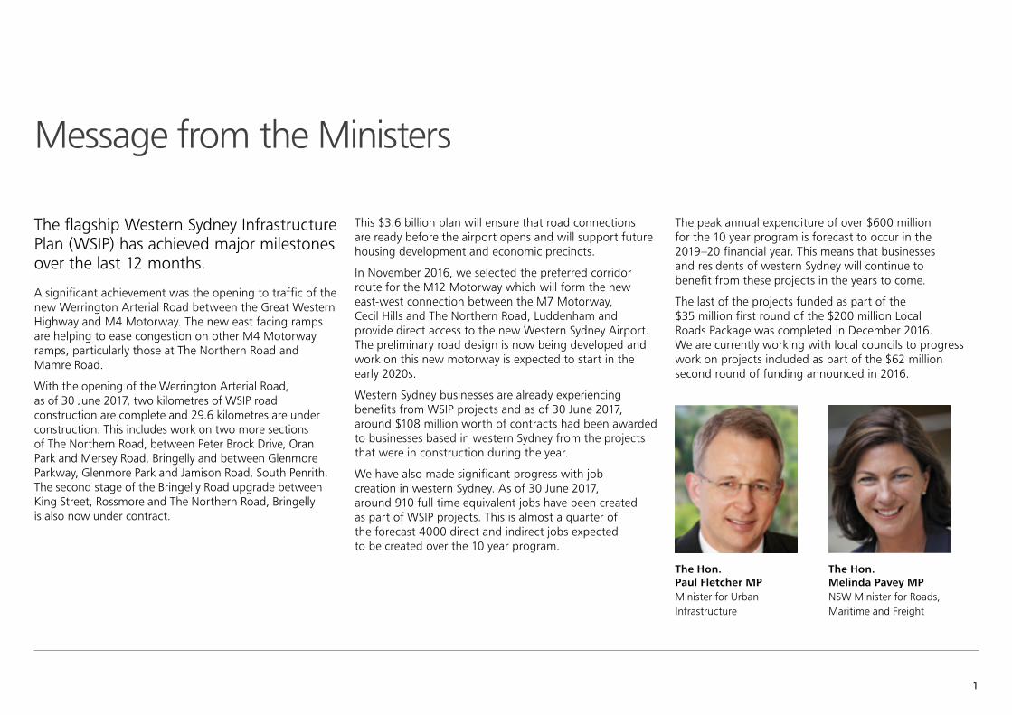
Message from the Ministers
The Hon. Paul Fletcher MPMinister for Urban Infrastructure
The Hon. Melinda Pavey MP NSW Minister for Roads, Maritime and Freight
The peak annual expenditure of over $600 million for the 10 year program is forecast to occur in the 2019–20 financial year. This means that businesses and residents of western Sydney will continue to benefit from these projects in the years to come.
The last of the projects funded as part of the $35 million first round of the $200 million Local Roads Package was completed in December 2016. We are currently working with local councils to progress work on projects included as part of the $62 million second round of funding announced in 2016.
2 Western Sydney Infrastructure Plan | 1 July 2016 – 30 June 2017 Report Card
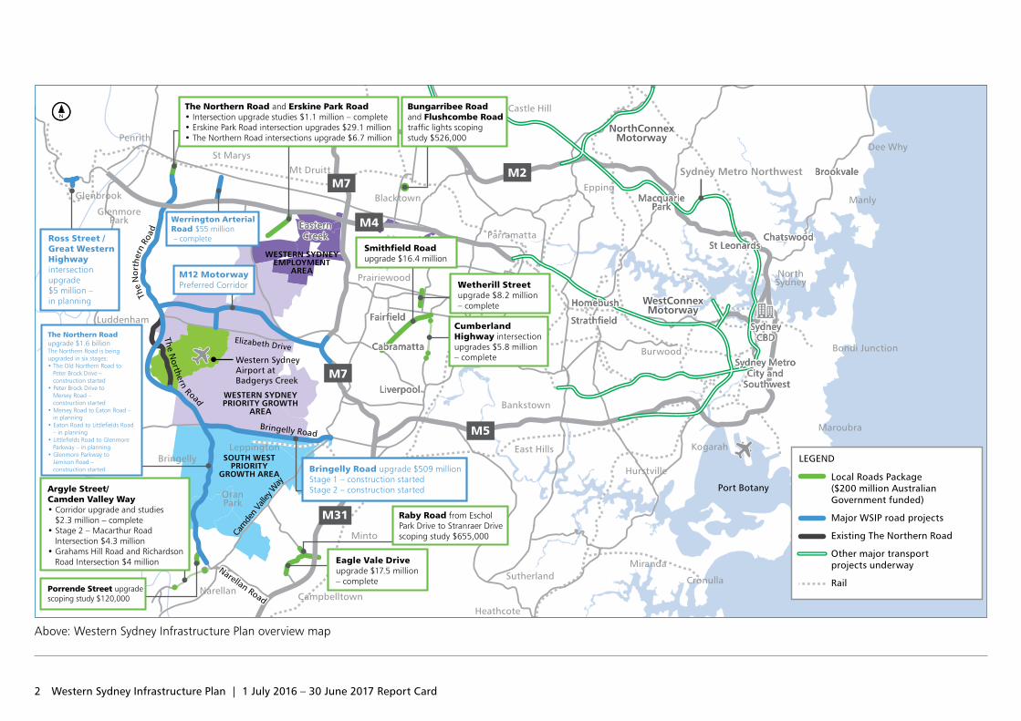
Above: Western Sydney Infrastructure Plan overview map
Port Botany
NorthConnexMotorway
NorthConnexMotorway
WestConnexMotorway
WestConnexMotorway
NarellanCampbelltown
Heathcote
SutherlandMiranda
Cronulla
East Hills
Bankstown
LiverpoolLiverpool
CabramattaCabramatta
FairfieldFairfield
Prairiewood
Parramatta
Blacktown
Castle Hill
Mt Druitt
St Marys
Penrith
GlenmorePark
Glenbrook
Luddenham
BringellyLeppington
OranPark
EppingMacquarie
ParkMacquarie
Park
StrathfieldStrathfield
HomebushHomebush
EasternCreek
EasternCreek
Burwood
Hurstville
Kogarah
Maroubra
Bondi Junction
SydneyCBD
SydneyCBD
Sydney Metro City and
Southwest
Sydney Metro City and
Southwest
NorthSydney
St LeonardsSt LeonardsChatswoodChatswood
Manly
BrookvaleBrookvale
Dee Why
Chullora
Minto
Sydney Metro NorthwestSydney Metro Northwest
The Northern Road upgrade $1.6 billionThe Northern Road is being upgraded in six stages:• The Old Northern Road to Peter Brock Drive – construction started• Peter Brock Drive to Mersey Road – construction started• Mersey Road to Eaton Road – in planning• Eaton Road to Littlefields Road – in planning• Littlefields Road to Glenmore Parkway – in planning• Glenmore Parkway to Jamison Road – construction started
M12 MotorwayPreferred Corridor
Elizabeth Drive
Bringelly Road
Narellan Road
Cam
den
Valle
y Way
The Northern R oad
The
Nor
ther
n Ro
ad
Werrington Arterial Road $55 million – completeRoss Street /
Great Western Highway intersection upgrade $5 million – in planning
Bringelly Road upgrade $509 millionStage 1 – construction started Stage 2 – construction started
M31
M5
M7
M7M2
M4
Western Sydney Airport at Badgerys Creek
WESTERN SYDNEYEMPLOYMENT
AREA
WESTERN SYDNEYPRIORITY GROWTH
AREA
SOUTH WESTPRIORITY
GROWTH AREA
Wetherill Street upgrade $8.2 million– complete
Eagle Vale Drive upgrade $17.5 million – complete
Cumberland Highway intersection upgrades $5.8 million– complete
Smithfield Road upgrade $16.4 million
Argyle Street/Camden Valley Way • Corridor upgrade and studies $2.3 million – complete• Stage 2 – Macarthur Road Intersection $4.3 million• Grahams Hill Road and Richardson Road Intersection $4 million
Raby Road from Eschol Park Drive to Stranraer Drive scoping study $655,000
The Northern Road and Erskine Park Road • Intersection upgrade studies $1.1 million – complete• Erskine Park Road intersection upgrades $29.1 million• The Northern Road intersections upgrade $6.7 million
Bungarribee Road and Flushcombe Road traffic lights scoping study $526,000
Porrende Street upgrade scoping study $120,000
Local Roads Package ($200 million Australian Government funded)
Major WSIP road projects
Existing The Northern Road
Other major transport projects underway
Rail
LEGEND
3
The Australian and NSW governments announced in April 2014 they are jointly funding the 10 year, $3.6 billion road investment program for western Sydney.
The Western Sydney Infrastructure Plan (WSIP) is delivering major road infrastructure upgrades to support an integrated transport solution for the region and capitalise on the economic benefits from developing the Western Sydney Airport at Badgerys Creek.
The Australian Government is investing $200 million in a Local Roads Package as part of WSIP, allowing western Sydney councils to deliver improved road connections that support the Western Sydney Infrastructure Plan.
These high quality road improvements will deliver significant, ongoing safety and congestion‑relieving benefits for customers.
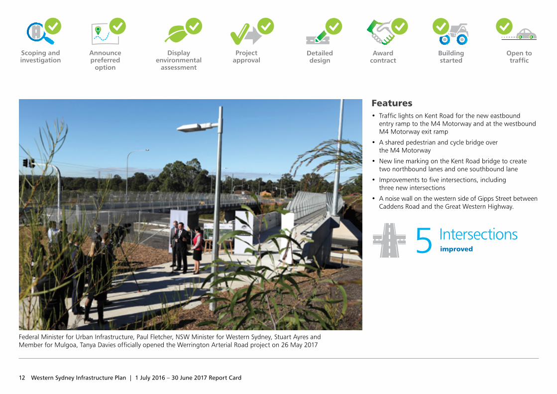
The Werrington Arterial Road upgrade opened to traffic in May 2017. This is the first major project to be completed as part of WSIP, providing road users better and safer access between the M4 Motorway and the Great Western Highway.
The 10 kilometre Bringelly Road upgrade is being delivered in two stages between Camden Valley Way at Leppington and The Northern Road at Bringelly.
• Stage 1 is a 5.7 kilometre section between Camden Valley Way, Leppington and King Street, Rossmore and is currently being built.
• Stage 2 is a 4.3 kilometre section between King Street, Rossmore and The Northern Road, Bringelly. A sod‑turning event was held in June 2017 to mark award of this contract.
The upgrade will generally provide a four lane divided road with six lanes between Eastwood Road to Cowpasture Road (south), through the future Leppington Town Centre.
The Northern Road upgrade will see around 35 kilometres of road upgraded between The Old Northern Road at Narellan and Jamison Road at South Penrith. The overall upgrade is being delivered in six sections between:
• The Old Northern Road, Narellan and Peter Brock Drive, Oran Park (3.3 kilometres) – construction started in early 2016
• Peter Brock Drive, Oran Park and Mersey Road, Bringelly (11.3 kilometres) – A sod‑turning event was held in June 2017 to mark award of this contract.
• Mersey Road, Bringelly and Eaton Road, Luddenham (5.5 kilometres) – EIS and concept design was on public display until 2 August 2017
• Eaton Road, Luddenham and Littlefields Road, Luddenham (4.5 kilometres) – EIS and concept design was on public display until 2 August 2017
• Littlefields Road, Luddenham and Glenmore Parkway, Glenmore Park (six kilometres) – EIS and concept design was on public display until 2 August 2017
• Glenmore Parkway, Glenmore Park and Jamison Road, South Penrith (four kilometres) – A sod turning event was held in June 2017 to mark award of this contract.
The Northern Road upgrade will cater for future traffic from planned residential and commercial developments.
The new M12 Motorway will provide direct access to the Western Sydney Airport at Badgerys Creek and connect to Sydney’s motorway network.
The Glenbrook Intersection upgrade will improve safety and access at the intersection of Ross Street and the Great Western Highway, Glenbrook.
Western Sydney Infrastructure Plan overview
4 Western Sydney Infrastructure Plan | 1 July 2016 – 30 June 2017 Report Card
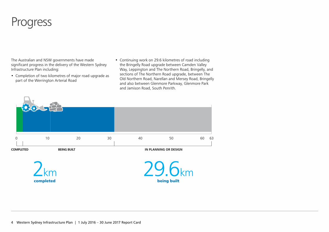
The Australian and NSW governments have made significant progress in the delivery of the Western Sydney Infrastructure Plan including:
• Completion of two kilometres of major road upgrade as part of the Werrington Arterial Road
• Continuing work on 29.6 kilometres of road including the Bringelly Road upgrade between Camden Valley Way, Leppington and The Northern Road, Bringelly, and sections of The Northern Road upgrade, between The Old Northern Road, Narellan and Mersey Road, Bringelly and also between Glenmore Parkway, Glenmore Park and Jamison Road, South Penrith.
2kmcompleted
29.6kmbeing built
9kmRoads being built
BEING BUILTCOMPLETED IN PLANNING OR DESIGN
0 10 20 30 40 50 60 63
Progress
5
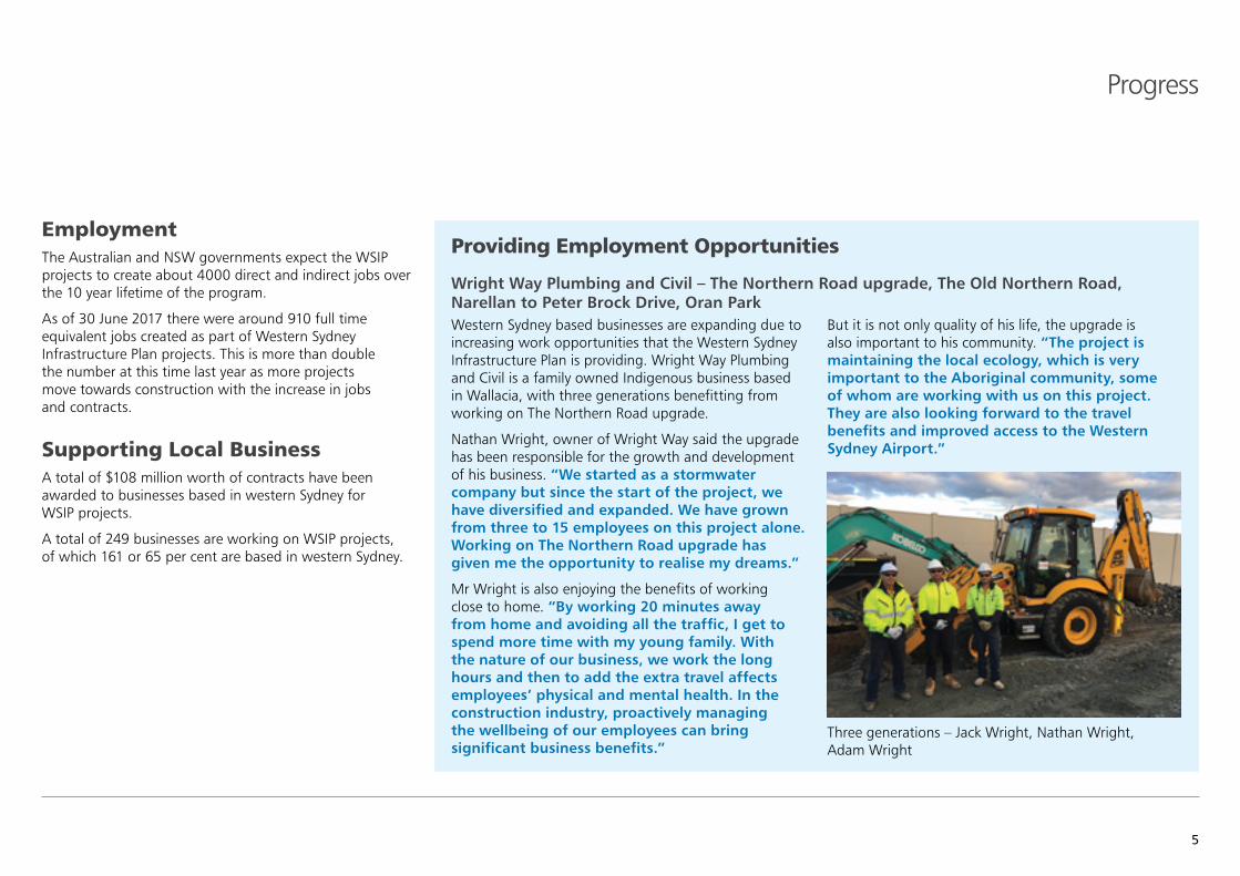
Providing Employment Opportunities
Wright Way Plumbing and Civil – The Northern Road upgrade, The Old Northern Road, Narellan to Peter Brock Drive, Oran ParkWestern Sydney based businesses are expanding due to increasing work opportunities that the Western Sydney Infrastructure Plan is providing. Wright Way Plumbing and Civil is a family owned Indigenous business based in Wallacia, with three generations benefitting from working on The Northern Road upgrade.
Nathan Wright, owner of Wright Way said the upgrade has been responsible for the growth and development of his business. “We started as a stormwater company but since the start of the project, we have diversified and expanded. We have grown from three to 15 employees on this project alone. Working on The Northern Road upgrade has given me the opportunity to realise my dreams.”
Mr Wright is also enjoying the benefits of working close to home. “By working 20 minutes away from home and avoiding all the traffic, I get to spend more time with my young family. With the nature of our business, we work the long hours and then to add the extra travel affects employees’ physical and mental health. In the construction industry, proactively managing the wellbeing of our employees can bring significant business benefits.”
But it is not only quality of his life, the upgrade is also important to his community. “The project is maintaining the local ecology, which is very important to the Aboriginal community, some of whom are working with us on this project. They are also looking forward to the travel benefits and improved access to the Western Sydney Airport.”
Employment The Australian and NSW governments expect the WSIP projects to create about 4000 direct and indirect jobs over the 10 year lifetime of the program.
As of 30 June 2017 there were around 910 full time equivalent jobs created as part of Western Sydney Infrastructure Plan projects. This is more than double the number at this time last year as more projects move towards construction with the increase in jobs and contracts.
Supporting Local Business A total of $108 million worth of contracts have been awarded to businesses based in western Sydney for WSIP projects.
A total of 249 businesses are working on WSIP projects, of which 161 or 65 per cent are based in western Sydney.
Progress
Three generations – Jack Wright, Nathan Wright, Adam Wright
6 Western Sydney Infrastructure Plan | 1 July 2016 – 30 June 2017 Report Card
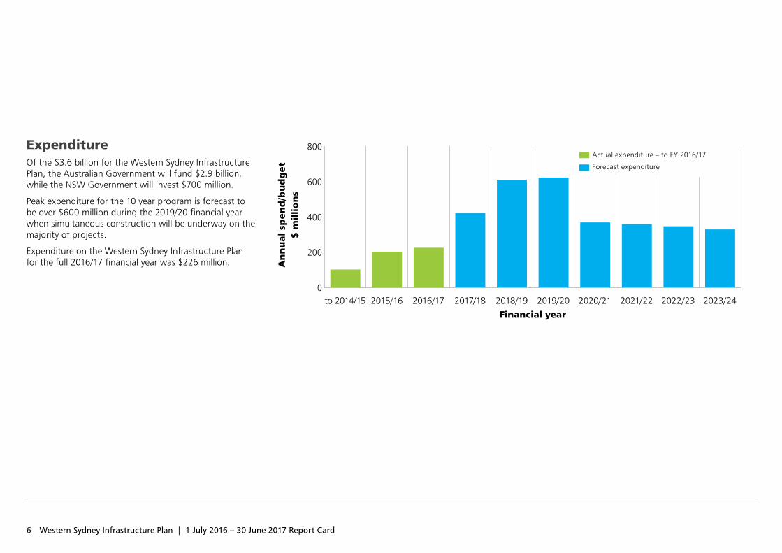
ExpenditureOf the $3.6 billion for the Western Sydney Infrastructure Plan, the Australian Government will fund $2.9 billion, while the NSW Government will invest $700 million.
Peak expenditure for the 10 year program is forecast to be over $600 million during the 2019/20 financial year when simultaneous construction will be underway on the majority of projects.
Expenditure on the Western Sydney Infrastructure Plan for the full 2016/17 financial year was $226 million.
$ m
illi
on
sA
nn
ual
sp
end
/bu
dg
et
to 2014/15 2015/16 2016/17 2017/18 2018/19 2019/20 2020/21 2021/22 2022/23 2023/24Financial year
0
200
400
600
800 Actual expenditure – to FY 2016/17
Forecast expenditure
7
Progress
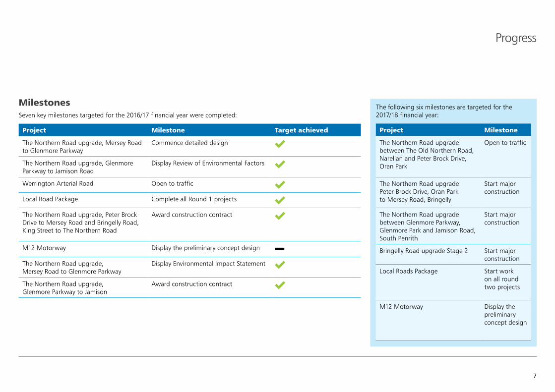
MilestonesSeven key milestones targeted for the 2016/17 financial year were completed:
Project Milestone Target achieved
The Northern Road upgrade, Mersey Road to Glenmore Parkway
Commence detailed design
The Northern Road upgrade, Glenmore Parkway to Jamison Road
Display Review of Environmental Factors
Werrington Arterial Road Open to traffic
Local Road Package Complete all Round 1 projects
The Northern Road upgrade, Peter Brock Drive to Mersey Road and Bringelly Road, King Street to The Northern Road
Award construction contract
M12 Motorway Display the preliminary concept design
The Northern Road upgrade, Mersey Road to Glenmore Parkway
Display Environmental Impact Statement
The Northern Road upgrade, Glenmore Parkway to Jamison
Award construction contract
The following six milestones are targeted for the 2017/18 financial year:
Project Milestone
The Northern Road upgrade between The Old Northern Road, Narellan and Peter Brock Drive, Oran Park
Open to traffic
The Northern Road upgrade Peter Brock Drive, Oran Park to Mersey Road, Bringelly
Start major construction
The Northern Road upgrade between Glenmore Parkway, Glenmore Park and Jamison Road, South Penrith
Start major construction
Bringelly Road upgrade Stage 2 Start major construction
Local Roads Package Start work on all round two projects
M12 Motorway Display the preliminary concept design
8 Western Sydney Infrastructure Plan | 1 July 2016 – 30 June 2017 Report Card
Environment Roads and Maritime is committed to the delivery of efficient and effective environmental outcomes throughout the planning and construction of projects within the Western Sydney Infrastructure Plan. This includes providing advice on the planning process, monitoring construction activities to mitigate the impact on the environment, and liaising with government and community stakeholders to address concerns.
Performance of construction contractors is monitored via fortnightly site inspections and scheduled management system audits. Contractors are assessed against best environmental management practices and encouraged to look for innovation to achieve the outcomes.
During February and March 2017, prolonged periods of heavy rainfall were experienced with over 330mm of rainfall received on the Bringelly Road and The Northern Road upgrades. Pre‑rainfall preparation carried out by the project teams resulted in no major environmental incidents despite the extreme weather event.
A number of environmental impact assessments have been carried out for projects in both development and construction. Assessments have included an addendum Review of Environmental Factors (REF) for The Northern Road upgrade (between The Old Northern Road and Peter Brock Drive) and for Bringelly Road upgrade stage 1. An Environmental Impact Statement (EIS) was prepared for The Northern Road upgrade between Mersey Road and Glenmore Parkway (designated as Critical State Significant Infrastructure).
Construction Environmental Management Plans for two new projects as part of The Northern Road upgrade and for the second stage of the Bringelly Road upgrade, were reviewed and approved prior to early site work starting in June 2017.
The purchase of biodiversity offset credits for WSIP under the NSW BioBanking scheme is ongoing. The purpose of this is to discharge future offset liabilities for WSIP projects.
A biodiversity offset strategy has been prepared for WSIP projects to offset the impact from loss of vegetation and habitat.
One measure is purchasing biodiversity offset credits through The NSW BioBanking scheme. These credits compensate for the lost vegetation by protecting and managing biodiversity in one area in exchange for the impact created by a project.
BioBanking allows ‘biodiversity credits’ to be generated by landowners and developers who agree to enhance and protect biodiversity values on their land through a BioBanking agreement. These credits can then be sold, generating funds for the management of the site.
Biodiversity offsets help achieve long‑term conservation outcomes.
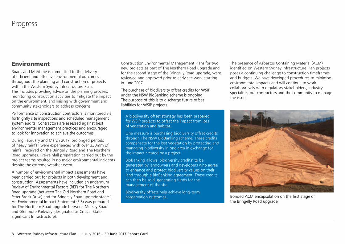
The presence of Asbestos Containing Material (ACM) identified on Western Sydney Infrastructure Plan projects poses a continuing challenge to construction timeframes and budgets. We have developed procedures to minimise environmental impacts and will continue to work collaboratively with regulatory stakeholders, industry specialists, our contractors and the community to manage the issue.
Progress
Bonded ACM encapsulation on the first stage of the Bringelly Road upgrade
9
Work, Health and Safety Roads and Maritime is working collaboratively with our industry partners to ensure the health and well‑being of workers and the public during construction of Western Sydney Infrastructure Plan projects.
Industry Partner ForumThe Western Sydney Project Office held an Industry Partner Forum in November 2016 with 100 attendees, including representatives from all construction industry partners engaged on Western Sydney Infrastructure Plan projects. During the forum, industry partners and Roads and Maritime shared experiences and solutions for preventing and managing the most high priority and frequent incident types. These incidents were related to utility strikes, working near mobile plant and working adjacent to live traffic.
Our staff and industry partners have taken part in training and education programs throughout the year. This included Psychology of Safety leadership training and an education session on mental health carried out jointly with an industry partner, Heavy Vehicle Chain of Responsibility Training, and a pilot course for Active Safety Leadership.
WHS Site Visits The Roads and Maritime leadership team have continued their program of site inspections and hazard identification activities at all active Western Sydney Infrastructure Plan sites. The activities focused on during inspections included Heavy Vehicle Chain of Responsibility, Critical Control Audit and assurance activities for controls relating to working adjacent to live traffic, working near mobile plant and working close to services and utilities. There is a continuing focus on public safety. Recommendations of improvement are shared and discussed with industry partners as improvement opportunities.
WHS WorkshopsProject workshops integrate hazard identification and risk assessment methods early in the project design process and assist in eliminating or minimising the risk of injury to staff, contractors and ultimately the road users.
The following workshops were held between July 2016 and June 2017:
• The Northern Road upgrade between Mersey Road andEaton Road – value engineering, risk, constructability,health and safety in design workshop
• The Northern Road upgrade between Eaton Roadand Littlefields Road – value engineering, risk andconstructability workshop
• The Northern Road upgrade between GlenmoreParkway and Jamison Road – design review, risk,health and safety in design workshop.
Progress
10 Western Sydney Infrastructure Plan | 1 July 2016 – 30 June 2017 Report Card
Projectupdateproject update newsletters,
letters and notifications sent from July 2016 to June 2017
193,369
Progress
Consultation Roads and Maritime is committed to transparent and inclusive consultation across development projects. We work collaboratively with residents, stakeholders, interest groups, community representatives and councils to gain feedback and suggestions. This assists decision making and planning to, where possible, achieve negotiated outcomes.
These opportunities occur at specific project milestones such as selecting new road corridor alignments or during the display of environmental assessments.
We encourage the community to have a say at important milestones during project development through:
• one‑on‑one meetings
• community information sessions
• information displays
• postal submissions
• Roads and Maritime and other NSW Government websites.
Information on Western Sydney Infrastructure Plan projects is provided through:
• project update newsletters
• regular website updates
• social media
• letters to land owners and residents
• staff visiting affected land owners and residents
• electronic message signs targeting road users.
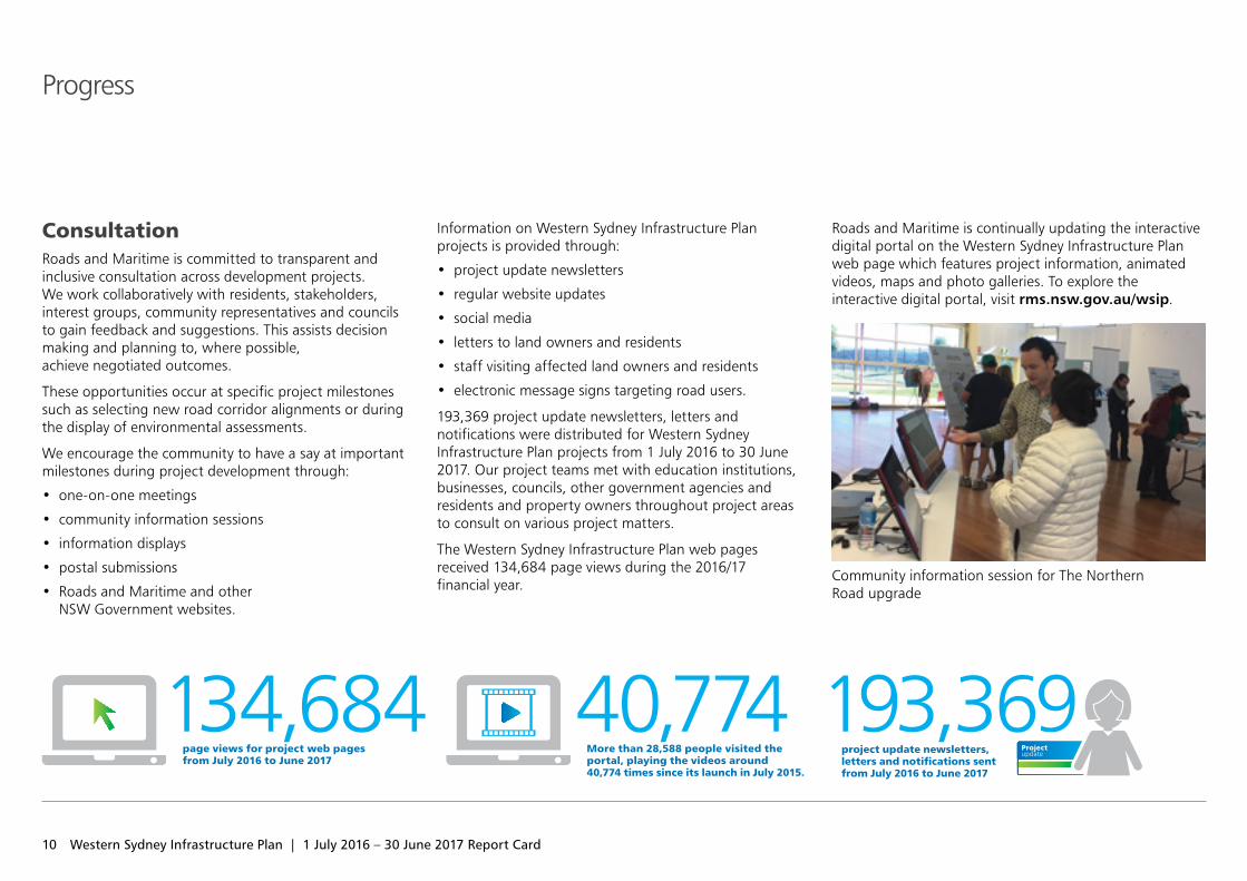
193,369 project update newsletters, letters and notifications were distributed for Western Sydney Infrastructure Plan projects from 1 July 2016 to 30 June 2017. Our project teams met with education institutions, businesses, councils, other government agencies and residents and property owners throughout project areas to consult on various project matters.
The Western Sydney Infrastructure Plan web pages received 134,684 page views during the 2016/17 financial year.
Roads and Maritime is continually updating the interactive digital portal on the Western Sydney Infrastructure Plan web page which features project information, animated videos, maps and photo galleries. To explore the interactive digital portal, visit rms.nsw.gov.au/wsip.
Community information session for The Northern Road upgrade
page views for project web pages from July 2016 to June 2017
134,684More than 28,588 people visited the portal, playing the videos around 40,774 times since its launch in July 2015.
40,774
M4 Motorway to the Great Western Highway, Claremont MeadowsThe upgrade of Gipps Street and Kent Road to form the Werrington Arterial Road is now complete. The new east facing ramps to the M4 Motorway opened to traffic in May 2017.
The upgrade included widening a two‑kilometre section of the Kent Road and Gipps Street corridor to four lanes as well as two new east facing ramps to the M4 Motorway. This has increased capacity, improving travel times for road users.
Benefits• Better access and network connections for motorists
and road freight by providing new east facing ramps on and off the M4 Motorway
• Reduced congestion and more reliable travel times, especially on The Northern Road and Mamre Road
• Enhanced safety at intersections with traffic lights, pedestrian crossings, separate turning lanes, and a separate shared path.
Project value: $55 million
Construction contractor: Burton Contractors Pty Ltd
Construction started: March 2015
Open to traffic: May 2017
Australian Government contribution: 50 per cent
Budget Saving: $15 million
NSW Government contribution: 50 per cent
Werrington Arterial Road Castle Hill
Epping
Blacktown
Mt Druitt
Chullora
Parramatta
MacquariePark
Strathfield
Hurstville
Prairiewood
Leppington
OranPark
Burwood
LiverpoolBankstown
St Marys
Cabramatta
Penrith
Sutherland Cronulla
Campbelltown
Miranda
Narellan
Camden
Heathcote
East HillsPrestons
M4
M4
M7
M5
M2
M31
Elizabeth Drive
Great Western Highway
King Georges Road
Bringelly Road
Narellan Road
Cam
den
Valle
y Way
The N
orthern Road
M7
WerringtonArterial Road
The
Nor
ther
n Ro
ad
Open to traffic
11
12 Western Sydney Infrastructure Plan | 1 July 2016 – 30 June 2017 Report Card
Features • Traffic lights on Kent Road for the new eastbound
entry ramp to the M4 Motorway and at the westbound M4 Motorway exit ramp
• A shared pedestrian and cycle bridge over the M4 Motorway
• New line marking on the Kent Road bridge to create two northbound lanes and one southbound lane
• Improvements to five intersections, including three new intersections
• A noise wall on the western side of Gipps Street between Caddens Road and the Great Western Highway.
Federal Minister for Urban Infrastructure, Paul Fletcher, NSW Minister for Western Sydney, Stuart Ayres and Member for Mulgoa, Tanya Davies officially opened the Werrington Arterial Road project on 26 May 2017
Scoping and investigation
Announce preferred
option
Display environmental
assessment
Project approval
Open to traffic
Detailed design
Award contract
Building started
improved5 Intersections
13
Bringelly Road upgradeThe $509 million Bringelly Road upgrade is being delivered in two stages to support the development of growth centres, employment and the new Western Sydney Airport at Badgerys Creek.
This 10 kilometre project includes upgrading Bringelly Road from two lanes to a six lane divided road between the Upper Canal bridge and Eastwood Road, through the future Leppington Town Centre.
The rest of Bringelly Road will be upgraded from two lanes to a four lane divided road with a central median, allowing for widening to six lanes, when required.
Key benefits:• Improved access to the Western Sydney Airport site at Badgerys Creek, Leppington Railway
Station, the new Leppington Town Centre and the M5 and M7 motorways
• Increased road capacity
• Improved safety for motorists
• Better bus priority and facilities
• More reliable travel times
• Improved access and safety for pedestrians and cyclists through an off‑road shared path.
to be improved9 Intersections
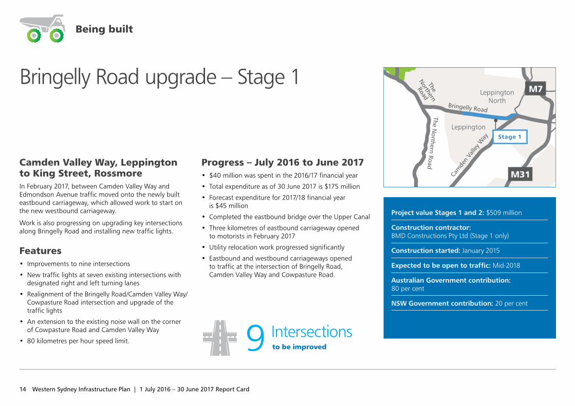
Camden Valley Way, Leppington to King Street, Rossmore In February 2017, between Camden Valley Way and Edmondson Avenue traffic moved onto the newly built eastbound carriageway, which allowed work to start on the new westbound carriageway.
Work is also progressing on upgrading key intersections along Bringelly Road and installing new traffic lights.
Features • Improvements to nine intersections
• New traffic lights at seven existing intersections with designated right and left turning lanes
• Realignment of the Bringelly Road/Camden Valley Way/Cowpasture Road intersection and upgrade of the traffic lights
• An extension to the existing noise wall on the corner of Cowpasture Road and Camden Valley Way
• 80 kilometres per hour speed limit.
Progress – July 2016 to June 2017 • $40 million was spent in the 2016/17 financial year
• Total expenditure as of 30 June 2017 is $175 million
• Forecast expenditure for 2017/18 financial year is $45 million
• Completed the eastbound bridge over the Upper Canal
• Three kilometres of eastbound carriageway opened to motorists in February 2017
• Utility relocation work progressed significantly
• Eastbound and westbound carriageways opened to traffic at the intersection of Bringelly Road, Camden Valley Way and Cowpasture Road.
Project value Stages 1 and 2: $509 million
Construction contractor: BMD Constructions Pty Ltd (Stage 1 only)
Construction started: January 2015
Expected to be open to traffic: Mid‑2018
Australian Government contribution: 80 per cent
NSW Government contribution: 20 per cent
Bringelly Road upgrade – Stage 1
Castle Hill
Epping
Blacktown
Mt Druitt
Chullora
Parramatta
MacquariePark
Strathfield
Hurstville
Prairiewood
Leppington
Burwood
LiverpoolBankstown
St Marys
Cabramatta
Penrith
Sutherland Cronulla
Campbelltown
Miranda
Narellan
Camden
Heathcote
East HillsPrestons
LeppingtonNorth
M4
M4
M7
M5
M2
M31
Elizabeth Drive
Great Western Highway
King Georges Road
Bringelly Road
Narellan Road
Cam
den
Valle
y Way
M7
WerringtonArterial Road
The
Nor
ther
n Ro
ad
The
Northern
Road
The Northern Road
Stage 1
Being built
14 Western Sydney Infrastructure Plan | 1 July 2016 – 30 June 2017 Report Card
15
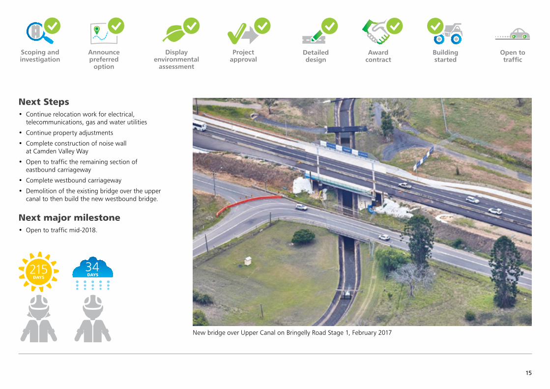
Next Steps • Continue relocation work for electrical,
telecommunications, gas and water utilities
• Continue property adjustments
• Complete construction of noise wall at Camden Valley Way
• Open to traffic the remaining section of eastbound carriageway
• Complete westbound carriageway
• Demolition of the existing bridge over the upper canal to then build the new westbound bridge.
Next major milestone • Open to traffic mid‑2018.
Scoping and investigation
Announce preferred
option
Display environmental
assessment
Project approval
Open to traffic
New bridge over Upper Canal on Bringelly Road Stage 1, February 2017
Detailed design
Award contract
Building started
34DAYS
215DAYS
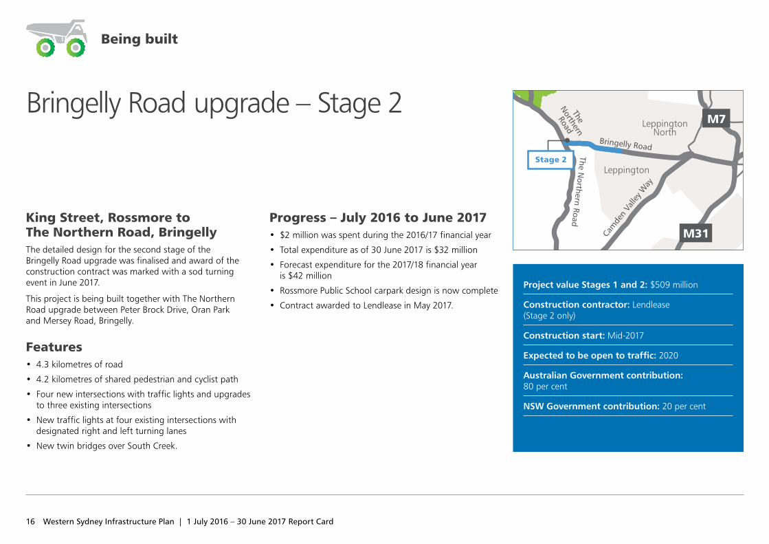
King Street, Rossmore to The Northern Road, BringellyThe detailed design for the second stage of the Bringelly Road upgrade was finalised and award of the construction contract was marked with a sod turning event in June 2017.
This project is being built together with The Northern Road upgrade between Peter Brock Drive, Oran Park and Mersey Road, Bringelly.
Features • 4.3 kilometres of road
• 4.2 kilometres of shared pedestrian and cyclist path
• Four new intersections with traffic lights and upgrades to three existing intersections
• New traffic lights at four existing intersections with designated right and left turning lanes
• New twin bridges over South Creek.
Progress – July 2016 to June 2017 • $2 million was spent during the 2016/17 financial year
• Total expenditure as of 30 June 2017 is $32 million
• Forecast expenditure for the 2017/18 financial year is $42 million
• Rossmore Public School carpark design is now complete
• Contract awarded to Lendlease in May 2017.
Project value Stages 1 and 2: $509 million
Construction contractor: Lendlease (Stage 2 only)
Construction start: Mid‑2017
Expected to be open to traffic: 2020
Australian Government contribution: 80 per cent
NSW Government contribution: 20 per cent
Bringelly Road upgrade – Stage 2
Castle Hill
Epping
Blacktown
Mt Druitt
Chullora
Parramatta
MacquariePark
Strathfield
Hurstville
Prairiewood
Leppington
Burwood
LiverpoolBankstown
St Marys
Cabramatta
Penrith
Sutherland Cronulla
Campbelltown
Miranda
Narellan
Camden
Heathcote
East HillsPrestons
LeppingtonNorth
M4
M4
M7
M5
M2
M31
Elizabeth Drive
Great Western Highway
King Georges Road
Bringelly Road
Narellan Road
Cam
den
Valle
y Way
M7
WerringtonArterial Road
The
Nor
ther
n Ro
ad
The
Northern
Road
The Northern Road
Stage 2
Being built
16 Western Sydney Infrastructure Plan | 1 July 2016 – 30 June 2017 Report Card
17
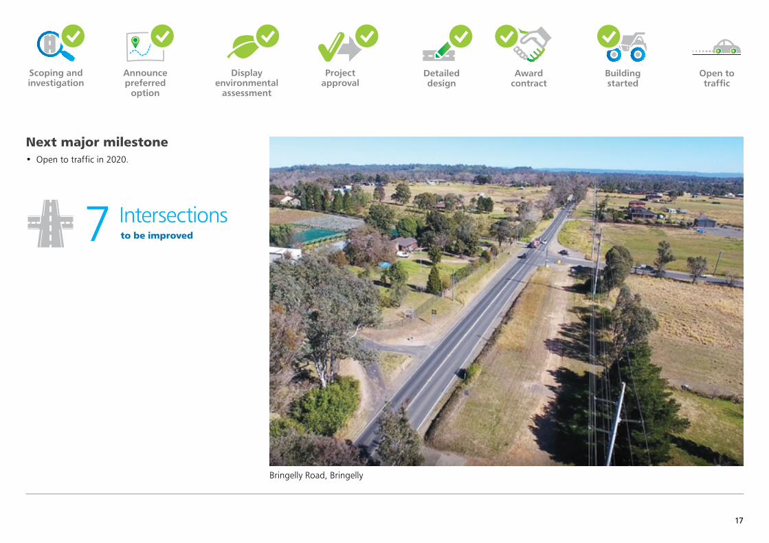
Next major milestone• Open to traffic in 2020.
Award contract
Scoping and investigation
Announce preferred
option
Display environmental
assessment
Project approval
Open to traffic
Detailed design
to be improved7 Intersections
Bringelly Road, Bringelly
Building started
18 Western Sydney Infrastructure Plan | 1 July 2016 – 30 June 2017 Report Card
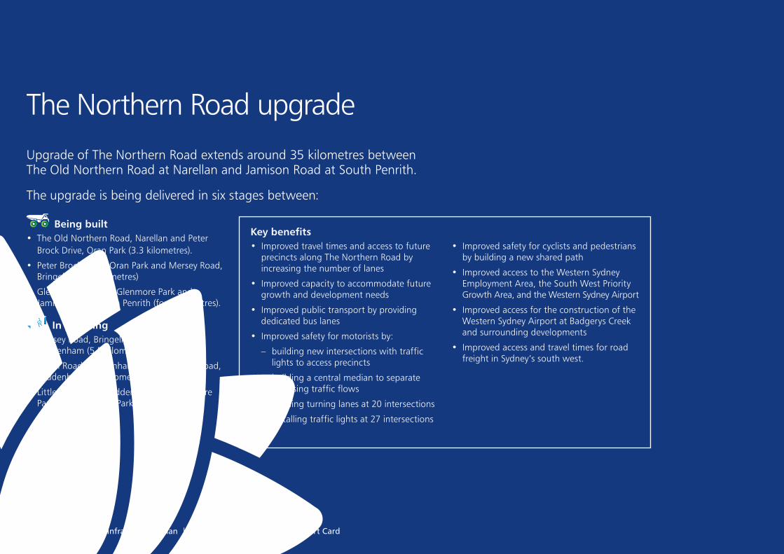
The Northern Road upgradeUpgrade of The Northern Road extends around 35 kilometres between The Old Northern Road at Narellan and Jamison Road at South Penrith.
The upgrade is being delivered in six stages between:
Being built• The Old Northern Road, Narellan and Peter
Brock Drive, Oran Park (3.3 kilometres).
• Peter Brock Drive, Oran Park and Mersey Road, Bringelly (11.3 kilometres)
• Glenmore Parkway, Glenmore Park and Jamison Road, South Penrith (four kilometres).
In planning • Mersey Road, Bringelly and Eaton Road,
Luddenham (5.5 kilometres)
• Eaton Road, Luddenham and Littlefields Road, Luddenham (4.5 kilometres)
• Littlefields Road, Luddenham and Glenmore Parkway, Glenmore Park (six kilometres).
Key benefits • Improved travel times and access to future
precincts along The Northern Road by increasing the number of lanes
• Improved capacity to accommodate future growth and development needs
• Improved public transport by providing dedicated bus lanes
• Improved safety for motorists by:
– building new intersections with traffic lights to access precincts
– building a central median to separate opposing traffic flows
– building turning lanes at 20 intersections
– installing traffic lights at 27 intersections
• Improved safety for cyclists and pedestrians by building a new shared path
• Improved access to the Western Sydney Employment Area, the South West Priority Growth Area, and the Western Sydney Airport
• Improved access for the construction of the Western Sydney Airport at Badgerys Creek and surrounding developments
• Improved access and travel times for road freight in Sydney’s south west.
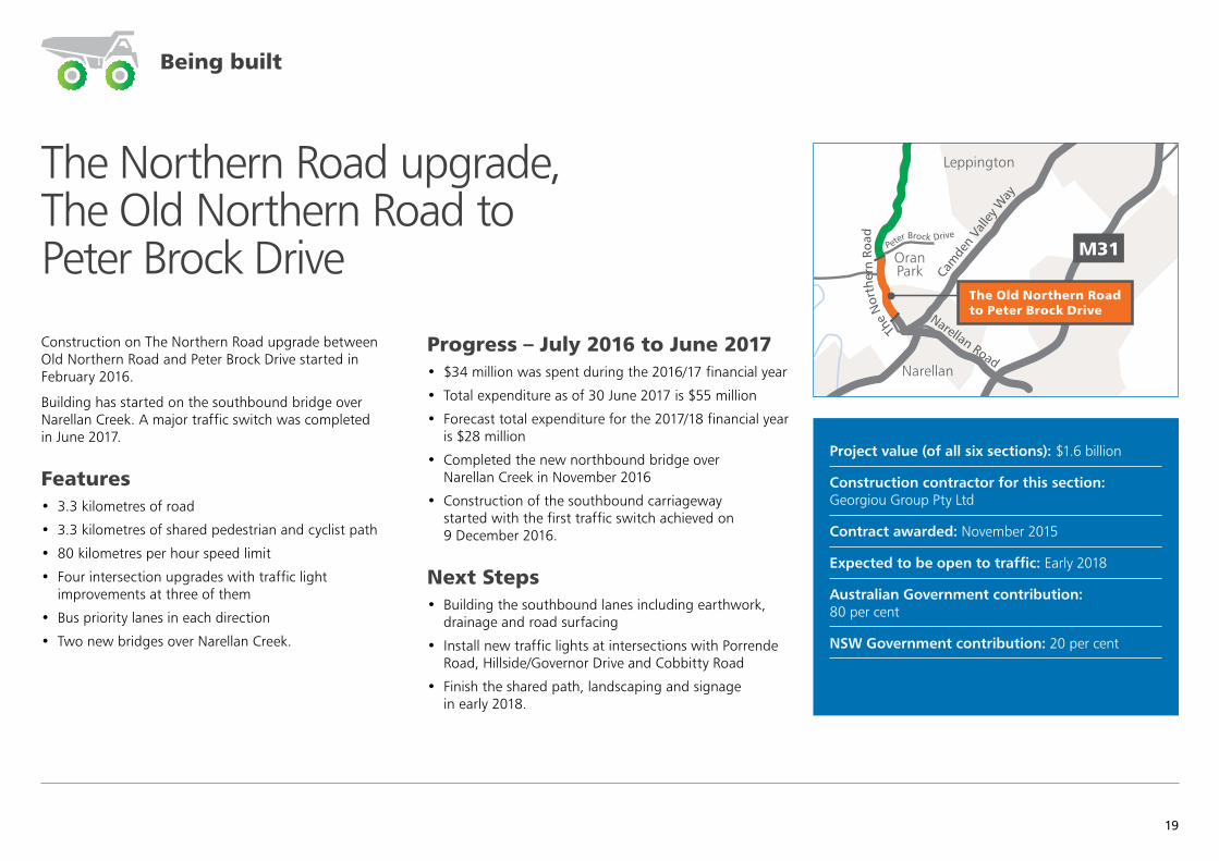
Construction on The Northern Road upgrade between Old Northern Road and Peter Brock Drive started in February 2016.
Building has started on the southbound bridge over Narellan Creek. A major traffic switch was completed in June 2017.
Features • 3.3 kilometres of road
• 3.3 kilometres of shared pedestrian and cyclist path
• 80 kilometres per hour speed limit
• Four intersection upgrades with traffic light improvements at three of them
• Bus priority lanes in each direction
• Two new bridges over Narellan Creek.
Progress – July 2016 to June 2017 • $34 million was spent during the 2016/17 financial year
• Total expenditure as of 30 June 2017 is $55 million
• Forecast total expenditure for the 2017/18 financial year is $28 million
• Completed the new northbound bridge over Narellan Creek in November 2016
• Construction of the southbound carriageway started with the first traffic switch achieved on 9 December 2016.
Next Steps • Building the southbound lanes including earthwork,
drainage and road surfacing
• Install new traffic lights at intersections with Porrende Road, Hillside/Governor Drive and Cobbitty Road
• Finish the shared path, landscaping and signage in early 2018.
Project value (of all six sections): $1.6 billion
Construction contractor for this section: Georgiou Group Pty Ltd
Contract awarded: November 2015
Expected to be open to traffic: Early 2018
Australian Government contribution: 80 per cent
NSW Government contribution: 20 per cent
The Northern Road upgrade, The Old Northern Road to Peter Brock Drive
Castle Hill
Epping
Blacktown
Mt Druitt
Chullora
Parramatta
MacquariePark
Strathfield
Hurstville
Prairiewood
Leppington
Burwood
LiverpoolBankstown
St Marys
Cabramatta
Penrith
Sutherland Cronulla
Campbelltown
Miranda
Narellan
Camden
Heathcote
East HillsPrestons
OranPark
M4
M4
M7
M5
M2
M31
Elizabeth Drive
Great Western Highway
King Georges Road
Bringelly Road
Narellan Road
Cam
den
Valle
y Way
The N
orthern Road
The
Nor
ther
n Ro
ad
M7
WerringtonArterial Road
The
Nor
ther
n Ro
ad
The Old Northern Road to Peter Brock Drive
Peter Brock Drive
Being built
19
20 Western Sydney Infrastructure Plan | 1 July 2016 – 30 June 2017 Report Card
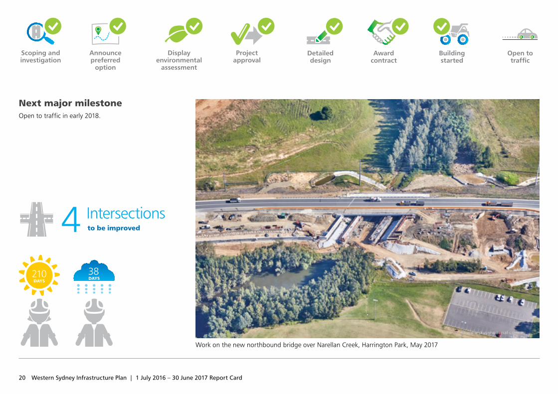
Next major milestoneOpen to traffic in early 2018.
Scoping and investigation
Announce preferred
option
Display environmental
assessment
Project approval
Open to traffic
Detailed design
Work on the new northbound bridge over Narellan Creek, Harrington Park, May 2017
Award contract
Building started
to be improved4 Intersections
38DAYS
210DAYS
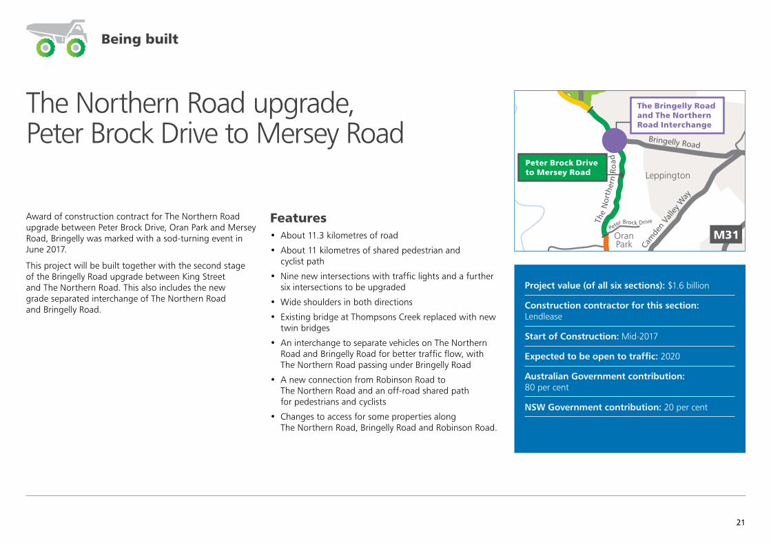
The Northern Road upgrade, Peter Brock Drive to Mersey Road
Award of construction contract for The Northern Road upgrade between Peter Brock Drive, Oran Park and Mersey Road, Bringelly was marked with a sod‑turning event in June 2017.
This project will be built together with the second stage of the Bringelly Road upgrade between King Street and The Northern Road. This also includes the new grade separated interchange of The Northern Road and Bringelly Road.
Features • About 11.3 kilometres of road
• About 11 kilometres of shared pedestrian and cyclist path
• Nine new intersections with traffic lights and a further six intersections to be upgraded
• Wide shoulders in both directions
• Existing bridge at Thompsons Creek replaced with new twin bridges
• An interchange to separate vehicles on The Northern Road and Bringelly Road for better traffic flow, with The Northern Road passing under Bringelly Road
• A new connection from Robinson Road to The Northern Road and an off‑road shared path for pedestrians and cyclists
• Changes to access for some properties along The Northern Road, Bringelly Road and Robinson Road.
Project value (of all six sections): $1.6 billion
Construction contractor for this section: Lendlease
Start of Construction: Mid‑2017
Expected to be open to traffic: 2020
Australian Government contribution: 80 per cent
NSW Government contribution: 20 per cent
Castle Hill
Epping
Blacktown
Mt Druitt
Chullora
Parramatta
MacquariePark
Strathfield
Hurstville
Prairiewood
Leppington
Burwood
LiverpoolBankstown
St Marys
Cabramatta
Penrith
Sutherland Cronulla
Campbelltown
Miranda
Narellan
Camden
Heathcote
East HillsPrestons
OranPark
M4
M4
M7
M5
M2
M31
Elizabeth Drive
Great Western Highway
King Georges Road
Bringelly Road
Narellan Road
Cam
den
Valle
y Way
M7
WerringtonArterial Road
The
Nor
ther
n Ro
ad
Peter Brock Drive to Mersey Road
The Bringelly Road and The Northern Road Interchange
Peter Brock DriveThe
Nor
ther
n R
oad
Being built
21
22 Western Sydney Infrastructure Plan | 1 July 2016 – 30 June 2017 Report Card
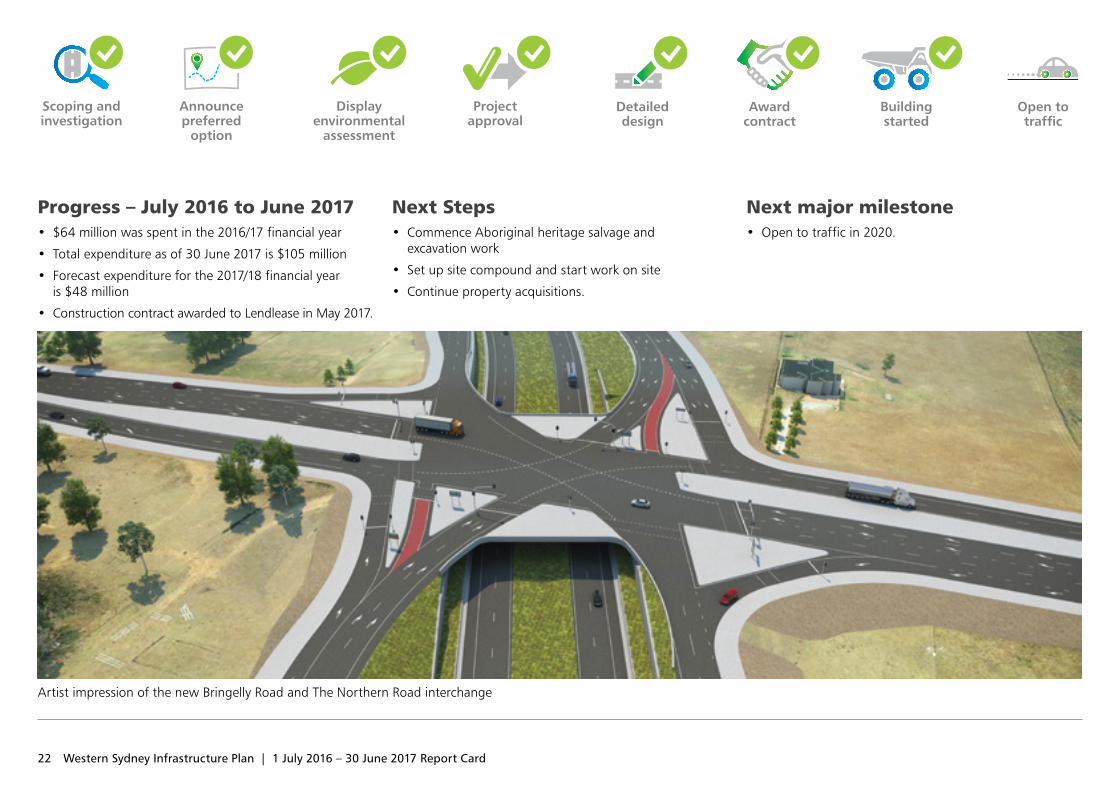
Progress – July 2016 to June 2017 • $64 million was spent in the 2016/17 financial year
• Total expenditure as of 30 June 2017 is $105 million
• Forecast expenditure for the 2017/18 financial year is $48 million
• Construction contract awarded to Lendlease in May 2017.
Next Steps • Commence Aboriginal heritage salvage and
excavation work
• Set up site compound and start work on site
• Continue property acquisitions.
Next major milestone • Open to traffic in 2020.
Building started
Scoping and investigation
Announce preferred
option
Display environmental
assessment
Project approval
Open to traffic
Detailed design
Artist impression of the new Bringelly Road and The Northern Road interchange
Award contract
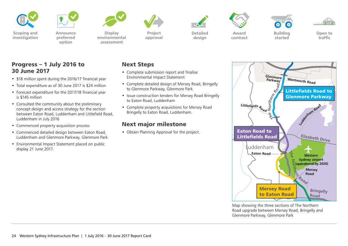
In February and July 2016, a preliminary design and access strategy was released for the proposed upgrade between Mersey Road, Bringelly and Glenmore Parkway, Glenmore Park for community and stakeholder feedback.
In consideration of stakeholder and community feedback and after further refinement of the road design, the concept design and Environmental Impact Statement have been developed for this section of The Northern Road upgrade.
The community was invited to provide their feedback between 21 June and 2 August 2017.
Features• Widened from two lanes to a six lane divided road
(two general traffic lanes and a kerbside bus lane in each direction), with a wide median to allow for an additional lane in each direction if required in the future
• Re‑alignment of the parts of the road that currently run through the Western Sydney Airport site and to bypass the Luddenham town centre
• Kerbside bus lanes, bus priority lanes at traffic lights and indented bus bays, where required
• Improving seven intersections, including installing new traffic lights and turning lanes at some intersections
• A new shared path for pedestrians and cyclists on the western side of the road and a new footpath on the eastern side of the road, where required.
The scope will be updated as the design progresses.
Project value (of all six sections): $1.6 billion
Design consultant: Jacobs Pty Ltd for the section between Mersey Road and Eaton Road
Design consultant: Mott MacDonald Pty Ltd for the section between Eaton Road and Littlefields Road
Design consultant: GHD Pty Ltd for the section between Littlefields Road and Glenmore Parkway
Expected start of construction: Mid‑2018 (in stages)
Expected to be open to traffic: 2020 (in stages)
Australian Government contribution: 80 per cent
NSW Government contribution: 20 per cent
The Northern Road upgrade, Mersey Road to Glenmore Parkway
Display environmental assessment
23
24 Western Sydney Infrastructure Plan | 1 July 2016 – 30 June 2017 Report Card
Progress – 1 July 2016 to 30 June 2017 • $18 million spent during the 2016/17 financial year
• Total expenditure as of 30 June 2017 is $24 million
• Forecast expenditure for the 2017/18 financial year is $145 million
• Consulted the community about the preliminary concept design and access strategy for the section between Eaton Road, Luddenham and Littlefield Road, Luddenham in July 2016
• Commenced property acquisition process
• Commenced detailed design between Eaton Road, Luddenham and Glenmore Parkway, Glenmore Park
• Environmental Impact Statement placed on public display 21 June 2017.
Next Steps • Complete submission report and finalise
Environmental Impact Statement
• Complete detailed design of Mersey Road, Bringelly to Glenmore Parkway, Glenmore Park
• Issue construction tenders for Mersey Road Bringelly to Eaton Road, Luddenham
• Complete property acquisitions for Mersey Road Bringelly to Eaton Road, Luddenham.
Next major milestone • Obtain Planning Approval for the project.
Map showing the three sections of The Northern Road upgrade between Mersey Road, Bringelly and Glenmore Parkway, Glenmore Park
Detailed design
Award contract
Building started
Scoping and investigation
Project approval
Open to traffic
Announce preferred
option
Display environmental
assessment
Wentworth Road
Mam
re Road
Eaton Road
Mersey Road
The OldNorthern Road
Peter Brock Drive
Ludd
en
ham Road
Blacktown
Mt Druitt
Mount Vernon
Leppington
Kemps Creek
Bringelly
Luddenham
OranPark
St Marys
Penrith
Narellan
Prestons
M4
M7
M31
Elizabeth Drive
Bringelly Road
Narellan Road
Cam
den
Valle
y W
ay
The
No
rth
ern
Roa
d
M7
The No
rthern Road
The
Nor
ther
n Ro
ad
Great Western Highway
Mersey Road to Eaton Road
Eaton Road to Littlefields Road
Peter Brock Drive to Mersey Road
The Old Northern Road to Peter Brock Drive
Littlefields Road to Glenmore Parkway
Western Sydney Parklands
Western Sydney airport
(operational by 2026)
Jamison Road
Littlefields Road
GlenmoreParkway
South West Priority Land Release Area
Western Sydney Employment Area
The Northern Road upgrade, Glenmore Parkway to Jamison Road
Castle Hill
Epping
Blacktown
Mt Druitt
Chullora
Parramatta
MacquariePark
Strathfield
Hurstville
Prairiewood
Leppington
Burwood
LiverpoolBankstown
St Marys
Cabramatta
Penrith
Sutherland Cronulla
Campbelltown
Miranda
Narellan
Camden
Heathcote
East HillsPrestons
OranPark
M4
M4
M5
M2
M31
Elizabeth Drive
Great Western Highway
King Georges Road
Bringelly Road
Narellan Road
Cam
den
Valle
y Way
The N
orthern Road
The
Nor
ther
n Ro
ad
M7
The
Nor
ther
n Ro
ad Glenmore Parkway to Jamison Road
Peter Brock Drive
M12 Motorway study area
JamisonRoad
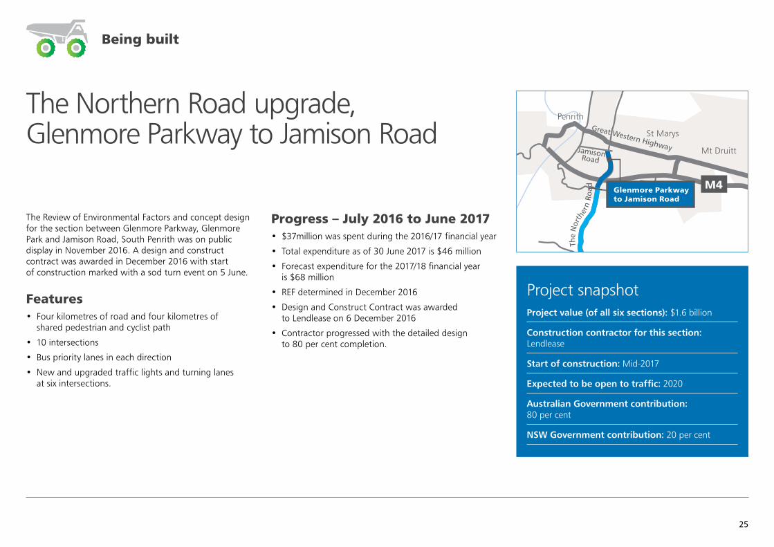
The Review of Environmental Factors and concept design for the section between Glenmore Parkway, Glenmore Park and Jamison Road, South Penrith was on public display in November 2016. A design and construct contract was awarded in December 2016 with start of construction marked with a sod turn event on 5 June.
Features • Four kilometres of road and four kilometres of
shared pedestrian and cyclist path
• 10 intersections
• Bus priority lanes in each direction
• New and upgraded traffic lights and turning lanes at six intersections.
Progress – July 2016 to June 2017 • $37million was spent during the 2016/17 financial year
• Total expenditure as of 30 June 2017 is $46 million
• Forecast expenditure for the 2017/18 financial year is $68 million
• REF determined in December 2016
• Design and Construct Contract was awarded to Lendlease on 6 December 2016
• Contractor progressed with the detailed design to 80 per cent completion.
Project snapshotProject value (of all six sections): $1.6 billion
Construction contractor for this section: Lendlease
Start of construction: Mid‑2017
Expected to be open to traffic: 2020
Australian Government contribution: 80 per cent
NSW Government contribution: 20 per cent
Being built
25
26 Western Sydney Infrastructure Plan | 1 July 2016 – 30 June 2017 Report Card
Scoping and investigation
Open to traffic
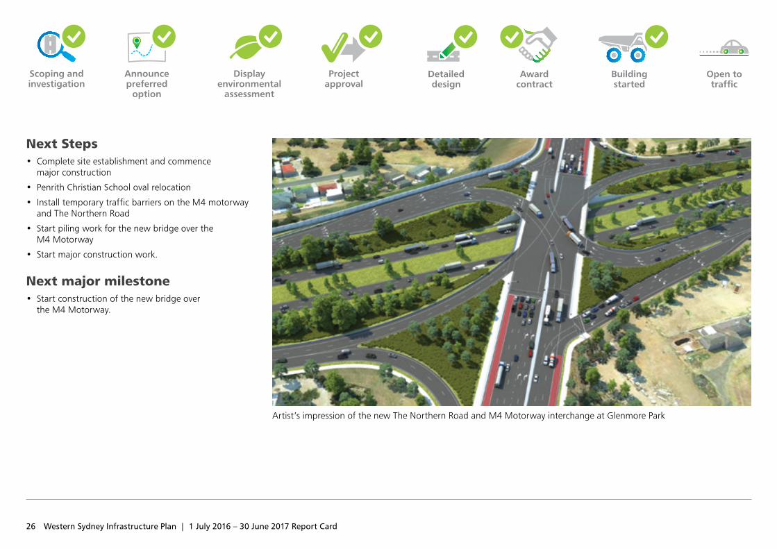
Next Steps • Complete site establishment and commence
major construction
• Penrith Christian School oval relocation
• Install temporary traffic barriers on the M4 motorway and The Northern Road
• Start piling work for the new bridge over the M4 Motorway
• Start major construction work.
Next major milestone • Start construction of the new bridge over
the M4 Motorway.
Artist’s impression of the new The Northern Road and M4 Motorway interchange at Glenmore Park
Award contract
Announce preferred
option
Display environmental
assessment
Project approval
Detailed design
Building started
27
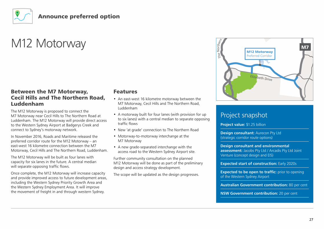
Between the M7 Motorway, Cecil Hills and The Northern Road, LuddenhamThe M12 Motorway is proposed to connect the M7 Motorway near Cecil Hills to The Northern Road at Luddenham. The M12 Motorway will provide direct access to the Western Sydney Airport at Badgerys Creek and connect to Sydney’s motorway network.
In November 2016, Roads and Maritime released the preferred corridor route for the M12 Motorway – an east‑west 16 kilometre connection between the M7 Motorway, Cecil Hills and The Northern Road, Luddenham.
The M12 Motorway will be built as four lanes with capacity for six lanes in the future. A central median will separate opposing traffic flows.
Once complete, the M12 Motorway will increase capacity and provide improved access to future development areas, including the Western Sydney Priority Growth Area and the Western Sydney Employment Area. It will improve the movement of freight in and through western Sydney.
Features• An east‑west 16 kilometre motorway between the
M7 Motorway, Cecil Hills and The Northern Road, Luddenham
• A motorway built for four lanes (with provision for up to six lanes) with a central median to separate opposing traffic flows
• New ‘at grade’ connection to The Northern Road
• Motorway‑to‑motorway interchange at the M7 Motorway
• A new grade‑separated interchange with the access road to the Western Sydney Airport site.
Further community consultation on the planned M12 Motorway will be done as part of the preliminary design and access strategy development.
The scope will be updated as the design progresses.
Project snapshotProject value: $1.25 billion
Design consultant: Aurecon Pty Ltd (strategic corridor route options)
Design consultant and environmental assessment: Jacobs Pty Ltd / Arcadis Pty Ltd Joint Venture (concept design and EIS)
Expected start of construction: Early 2020s
Expected to be open to traffic: prior to opening of the Western Sydney Airport
Australian Government contribution: 80 per cent
NSW Government contribution: 20 per cent
M12 Motorway
Castle Hill
Epping
Blacktown
Mt Druitt
Chullora
Parramatta
MacquariePark
Strathfield
Hurstville
Prairiewood
Leppington
Burwood
LiverpoolBankstown
St Marys
Cabramatta
Penrith
Sutherland Cronulla
Campbelltown
Miranda
Narellan
Camden
Heathcote
East HillsPrestons
OranPark
M4
M4
M5
M2
M31
Elizabeth Drive
Great Western Highway
King Georges Road
Bringelly Road
Narellan Road
Cam
den
Valle
y Way
The
Nor
ther
n R
oad
M7
The
Nor
ther
n Ro
ad
M12 Motorway Preferred Corridor
Announce preferred option
28 Western Sydney Infrastructure Plan | 1 July 2016 – 30 June 2017 Report Card
Detailed design
Award contract
Building started
Scoping and investigation
Announce preferred
option
Display environmental
assessment
Project approval
Open to traffic
Progress – 1 July 2016 to 30 June 2017 • $4.1 million was spent during the 2016/17 financial year
• Total expenditure as of 30 June 2017 is $8.3 million
• Forecast expenditure for the 2017/18 financial year is $21 million
• Announced the preferred corridor route in November 2016
• Engaged a consultant for the concept design and environmental assessment in February 2017
• Commenced field investigations for concept design and environmental assessment in May 2017
• Commenced additional investigations to refine the project scope and inform the preliminary design and access strategy.
Next Steps • Complete additional investigations to refine the
project scope and inform the preliminary design and access strategy
• Submit application for environmental assessment requirements
• Consult on the preliminary design and access strategy
• Complete field investigations for concept design and environment assessment.
Next major milestone • Announce the preliminary design and access strategy.
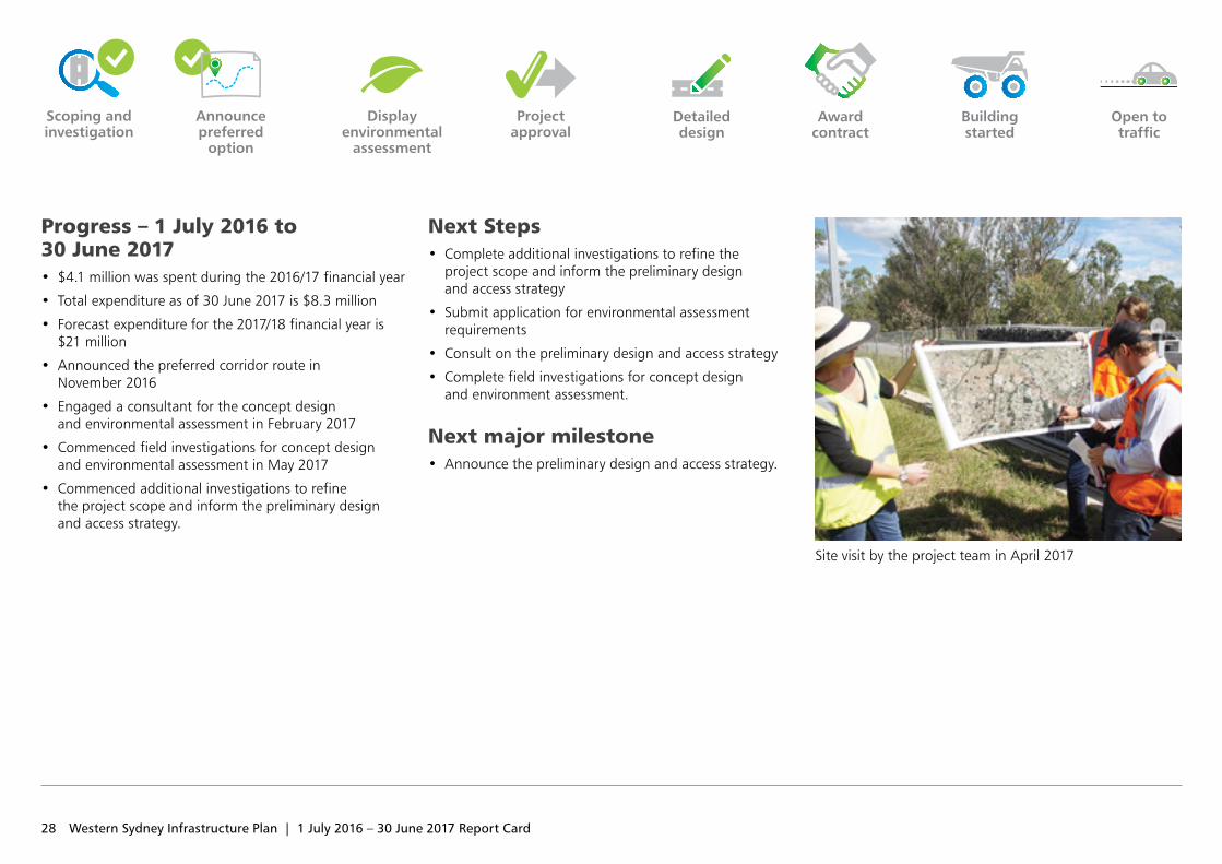
Site visit by the project team in April 2017
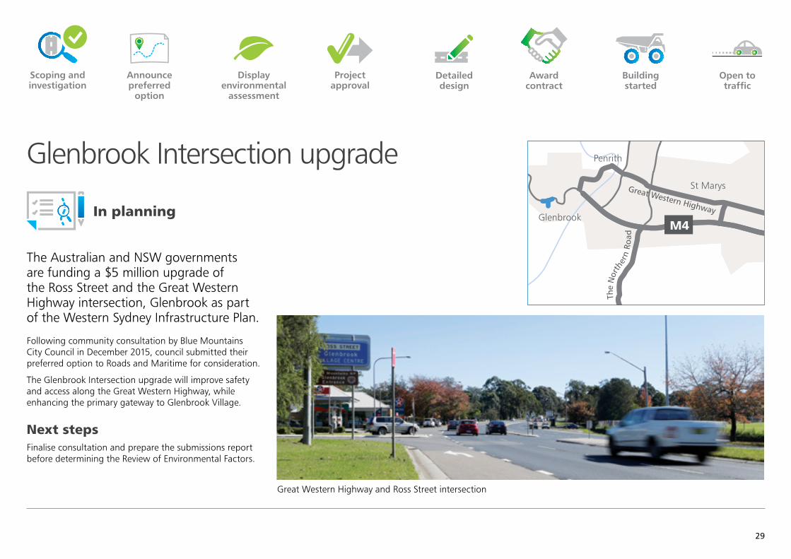
The Australian and NSW governments are funding a $5 million upgrade of the Ross Street and the Great Western Highway intersection, Glenbrook as part of the Western Sydney Infrastructure Plan.
Following community consultation by Blue Mountains City Council in December 2015, council submitted their preferred option to Roads and Maritime for consideration.
The Glenbrook Intersection upgrade will improve safety and access along the Great Western Highway, while enhancing the primary gateway to Glenbrook Village.
Next stepsFinalise consultation and prepare the submissions report before determining the Review of Environmental Factors.
Glenbrook Intersection upgradeCastle Hill
Epping
Blacktown
Mt Druitt
Chullora
Parramatta
MacquariePark
Strathfield
Hurstville
Prairiewood
Leppington
OranPark
Burwood
LiverpoolBankstown
St Marys
Cabramatta
Penrith
Sutherland Cronulla
Campbelltown
Miranda
Narellan
Camden
Heathcote
East HillsPrestons
GlenbrookM4
M7
M5
M2
M31
Elizabeth Drive
Great Western Highway
The
Nor
ther
n Ro
ad
King Georges Road
Bringelly Road
Narellan Road
Cam
den
Valle
y Way
The N
orthern Road
M7
Detailed design
Award contract
Building started
Scoping and investigation
Announce preferred
option
Display environmental
assessment
Project approval
Open to traffic
Great Western Highway and Ross Street intersection
In planning
29
30 Western Sydney Infrastructure Plan | 1 July 2016 – 30 June 2017 Report Card
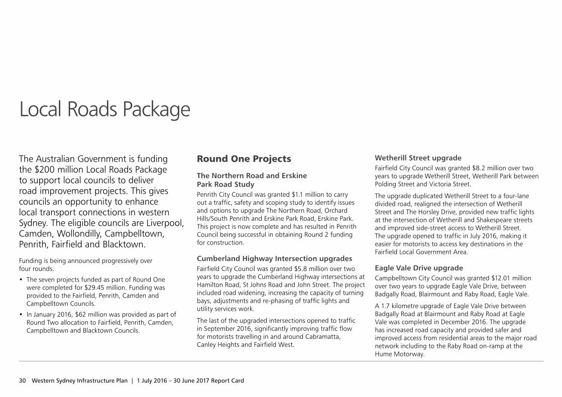
The Australian Government is funding the $200 million Local Roads Package to support local councils to deliver road improvement projects. This gives councils an opportunity to enhance local transport connections in western Sydney. The eligible councils are Liverpool, Camden, Wollondilly, Campbelltown, Penrith, Fairfield and Blacktown.
Funding is being announced progressively over four rounds.
• The seven projects funded as part of Round One were completed for $29.45 million. Funding was provided to the Fairfield, Penrith, Camden and Campbelltown Councils.
• In January 2016, $62 million was provided as part of Round Two allocation to Fairfield, Penrith, Camden, Campbelltown and Blacktown Councils.
Round One Projects
The Northern Road and Erskine Park Road Study Penrith City Council was granted $1.1 million to carry out a traffic, safety and scoping study to identify issues and options to upgrade The Northern Road, Orchard Hills/South Penrith and Erskine Park Road, Erskine Park. This project is now complete and has resulted in Penrith Council being successful in obtaining Round 2 funding for construction.
Cumberland Highway Intersection upgradesFairfield City Council was granted $5.8 million over two years to upgrade the Cumberland Highway intersections at Hamilton Road, St Johns Road and John Street. The project included road widening, increasing the capacity of turning bays, adjustments and re‑phasing of traffic lights and utility services work.
The last of the upgraded intersections opened to traffic in September 2016, significantly improving traffic flow for motorists travelling in and around Cabramatta, Canley Heights and Fairfield West.
Wetherill Street upgrade Fairfield City Council was granted $8.2 million over two years to upgrade Wetherill Street, Wetherill Park between Polding Street and Victoria Street.
The upgrade duplicated Wetherill Street to a four‑lane divided road, realigned the intersection of Wetherill Street and The Horsley Drive, provided new traffic lights at the intersection of Wetherill and Shakespeare streets and improved side‑street access to Wetherill Street. The upgrade opened to traffic in July 2016, making it easier for motorists to access key destinations in the Fairfield Local Government Area.
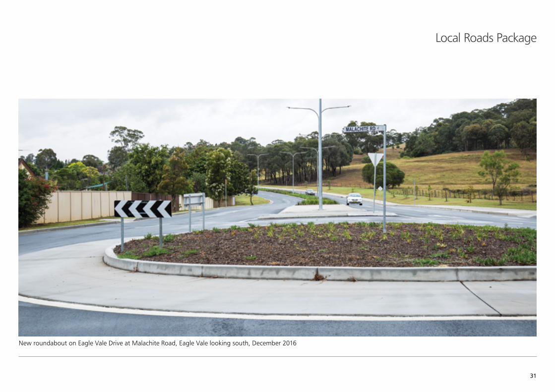
Eagle Vale Drive upgrade Campbelltown City Council was granted $12.01 million over two years to upgrade Eagle Vale Drive, between Badgally Road, Blairmount and Raby Road, Eagle Vale.
A 1.7 kilometre upgrade of Eagle Vale Drive between Badgally Road at Blairmount and Raby Road at Eagle Vale was completed in December 2016. The upgrade has increased road capacity and provided safer and improved access from residential areas to the major road network including to the Raby Road on‑ramp at the Hume Motorway.
Local Roads Package
31
Local Roads Package
New roundabout on Eagle Vale Drive at Malachite Road, Eagle Vale looking south, December 2016
32 Western Sydney Infrastructure Plan | 1 July 2016 – 30 June 2017 Report Card
Local Roads Package
Argyle Street/Camden Valley Way Corridor upgrade – Stage 1 Camden Council was granted $2.14 million over two years to construct new traffic lights at the intersection of Argyle Street and Oxley Street, Camden. The upgrade also included replacing a marked pedestrian crossing with pedestrian activated traffic lights on Argyle Street west of Hill Street, Camden. The project was completed in August 2016 and has improved safety and access, through the Camden town centre.
Argyle Street/Camden Valley Way upgrade study – Stage 2 Camden Council was granted $150,000 for a study to identify future road improvements along Camden Valley Way between the Camden Town Centre and The Northern Road. This project is complete and has resulted in Camden Council being successful in obtaining Round 2 funding for the upgrade of Grahams Hill Road and Camden Valley Way.
Argyle Street/Camden Valley Way/Macarthur Road Intersection Study Camden Council was granted $50,000 to do option testing and complete a concept design to improve safety and efficiency at this intersection. This work was completed in July 2015 and has resulted in Camden Council being successful in obtaining Round 2 funding for construction.
Round Two Projects
Smithfield Road upgrade Fairfield City Council was granted $16.4 million to upgrade Smithfield Road to a continuous two‑lane two‑way road. The project includes a number of intersection upgrades and realignment of Richards Road at Smithfield Road.
The detailed design is currently progressing. Construction is scheduled to start in late 2017 with completion expected in mid‑2019.
Erskine Park Road and Peppertree Drive Intersection upgrade Penrith City Council was granted $11.3 million to upgrade the existing intersection at Erskine Park Road and Peppertree Drive to a seagull intersection. The upgrade will significantly improve road safety and traffic efficiency. The detailed design is currently progressing and construction is scheduled to start in early 2018 and finish in mid‑2019.
Erskine Park Road and Bennett Road upgradePenrith City Council was granted $7.5 million to upgrade the intersection at Bennett Road and Erskine Park Road and install traffic lights. The upgrade will improve road safety and traffic efficiency. Construction is scheduled to start in early 2018 and finish in mid‑2019.
Erskine Park Road and Coonawarra Drive Intersection upgrade Penrith City Council was granted $6.9 million to upgrade the intersection at Coonawarra Drive and Erskine Park Road to a seagull intersection. The upgrade will improve road safety and traffic efficiency. The detailed design is currently progressing and construction is scheduled to start in early 2018 and finish in mid‑2019.
Erskine Park Road and Explorers Way Intersection upgrade Penrith City Council was granted $3.4 million to upgrade the intersection at Explorers Way and Erskine Park Road and install traffic lights. The upgrade will improve road safety and traffic efficiency.
At the completion of the Erskine Park Road intersection upgrades, Erskine Park Road will have been widened to four lanes between Bennett Road and Explorers Way to join the existing four lane section north of this location. Construction is scheduled to start in early 2018 and finish in mid‑2019.
33
The Northern Road Intersections upgrade Penrith City Council was granted $6.7 million to upgrade intersections on The Northern Road at the Great Western Highway and at Derby Street. A roundabout will also be built at the Bringelly Road/Caddens Road intersection.
The intersections form a part of the A9 corridor connecting Windsor to Campbelltown via Penrith. The upgrade of these intersections will significantly improve road safety and traffic efficiency.
The Bringelly Road/Caddens Road intersection was completed at the end of June 2017. Work is scheduled to commence in February 2018 and be completed in late 2018, for the other two intersection upgrades.
Camden Valley Way/Argyle Street – Stage 2 – Macarthur Road Intersection Camden Council was granted $4.3 million to realign Macarthur Road on the approach to Camden Valley Way and install new traffic lights at the Camden Valley Way and Macarthur Road intersection at Elderslie. Work is scheduled to start in late 2017 and be completed by late 2018.
Camden Valley Way/Argyle Street – Grahams Hill Road and Richardson Road Intersection Camden Council was granted $4.0 million to upgrade the intersection to include right turn bays on Camden Valley Way into Grahams Hill Road. The project also includes traffic light adjustments and a new shared path on the southern side of Camden Valley Way. The work on the intersection of Camden Valley Way and Richardson Road is scheduled to start in late 2017 and be completed in mid‑2018.
Raby Road from Eschol Park Drive to Stranraer Drive scoping study Campbelltown City Council was granted $655,000 to carry out traffic, safety and scoping studies to identify issues and options to upgrade Raby Road from Eschol Park Drive to Stranraer Drive. The study was completed in March 2017 and Council is now progressing concept designs at two intersections, Raby Road/Eagle Vale Drive and Raby Road/Spitfire Drive Council is proposing to seek construction funding as part of its Round Three project proposals.
Bungarribee Road and Flushcombe Road signalisation scoping Blacktown City Council was granted $526,000 to develop options and complete preliminary investigations for safety and efficiency improvement at this intersection.
The detailed design of the selected option is currently underway and scheduled for completion by November 2017.
Porrende Street upgrade scoping Camden Council was granted $120,000 to develop options and complete a concept design for Porrende Street between The Northern Road intersection and Grahams Hill Road. The concept design was completed in August 2017 and Council will be seeking construction funding as part of its Round Three project proposals.
Local Roads Package
For further information about the Western Sydney Infrastructure Plan visit the interactive digital portal
rms.nsw.gov.au/WSIP [email protected] Roads and Maritime Services PO Box 973 Parramatta NSW 2124
Western Sydney Infrastructure Plan 1 July 2016 – 30 June 2017 Report Card RMS 17.623 ISBN: 978‑1‑925737‑20‑2
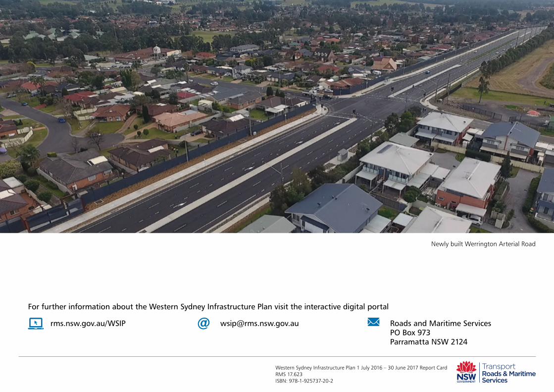
Newly built Werrington Arterial Road